Menalon Trail
How would you rate Menalon Trail?
Tap a star to share your experience and help other hikers.
Menalon Trail: A Complete Hiking Guide
HikeList Score
Menalon Trail scored 87/100 on HikeList's trail-quality metrics.
See score breakdownHide breakdown
- Ideal length 85
- Balanced challenge 100
- Scenery & wildness 98
- Varied terrain 94
- Accommodation 74
- Food & support 74
- Path quality 80
- Season flexibility 76
Computed from length, challenge, scenery & wildness, terrain variety, accommodation, food & support, path quality and season flexibility.
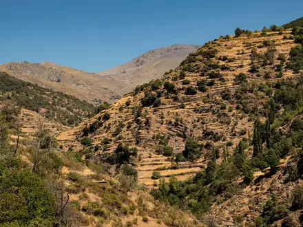
The Menalon Trail is a 75 km point-to-point hike through Arcadia in the central Peloponnese, Greece, usually walked from Stemnitsa to Lagkadia in 4-6 days. It is a moderate route, edging towards hard as a full traverse: well waymarked and non-technical, but with steep climbs, descents and roughly 700 m of ascent on an average day. It suits hikers who want a village-to-village mountain walk with guesthouses, stone settlements, forest paths, river gorges and historic monasteries.
Route Overview
The trail runs north and north-west across the Gortynia region, starting in Stemnitsa, a mountain village at about 1,000 m, and finishing in Lagkadia at a similar high elevation. It is divided into 8 official waymarked sections linking 9 villages in order: Stemnitsa, Dimitsana, Zygovisti, Elati, Vytina, Nymfasia, Magouliana, Valtesiniko and Lagkadia. Waymarking uses the standard yellow/black ERA blazes, and the route was the first in Greece to gain European Ramblers' Association certification. Plan accommodation village by village. For longer Greek waymarked walks, compare the E4 Greek section, E6 Greek section or the island-based Andros Route.
Old Mule Paths, Monasteries and Water Power
The Menalon Trail follows ancient mule paths that once connected the mountain villages and monasteries of Gortynia. Its early stages pass through the Lousios Gorge, where cliff-side monasteries form part of the region's religious landscape. Dimitsana also has major historical interest: it was a centre of gunpowder production, and its watermills supplied the 1821 Greek War of Independence. The Open-Air Water Power Museum near the village preserves this water-powered heritage.
Notable highlights
Lousios Gorge: A deep, forested river canyon between Stemnitsa and Dimitsana. It is one of the trail's most dramatic sections, with river scenery and monasteries built into the cliffs.
Prodromos Monastery (Moni Timiou Prodromou): A 16th-century active monastery wedged into a sheer cliff above the Lousios. It is a striking cultural stop on the gorge section.
Philosophou Monastery: The Old Philosophou Monastery was founded in the 10th century and is partly hidden in the rock. It is one of the oldest monastic sites in the area.
Open-Air Water Power Museum, Dimitsana: Restored watermills, a tannery and a gunpowder mill explain how Dimitsana's water power supported the 1821 revolution.
Tzavarena Bridge: A historic stone arch bridge from 1868 over the Mylaon River, adding a classic Peloponnese mountain feature to the route.
Magouliana: At about 1,360 m, this is the highest village in the Peloponnese and gives wide views over the Mainalo range.
Challenges to expect
Expect several thousand metres of cumulative climbing across the full trail, with about 700 m of ascent on an average day. The walking is non-technical and well marked, but the surface includes rocky paths, old stone-paved mule tracks, steep forest descents, riverbank sections and exposed higher ground. Avoid high summer heat and winter snow on the higher sections. Accommodation is village-based, so book ahead in smaller places.
HikeList Score
Menalon Trail scored 87/100 on HikeList's trail-quality metrics.
See score breakdownHide breakdown
- Ideal length 85
- Balanced challenge 100
- Scenery & wildness 98
- Varied terrain 94
- Accommodation 74
- Food & support 74
- Path quality 80
- Season flexibility 76
Computed from length, challenge, scenery & wildness, terrain variety, accommodation, food & support, path quality and season flexibility.
Show more data Show less
- Mountainous
- Forest
- Gorge
- River
- Rocky
- Dirt
- Paved
- Guesthouses
- Hotels
- Pet Friendly
- Water Sources
- Campsites
Download Our Full Guide to Menalon Trail FREE!
Get our comprehensive guide to this hike for free. Save it for later reading or print out at home.

In these collections
Photos from hikers
Taken on the trail by people who've reviewed Menalon Trail.
Menalon Trail: The Complete Guide
 i
Image by TETYANA
i
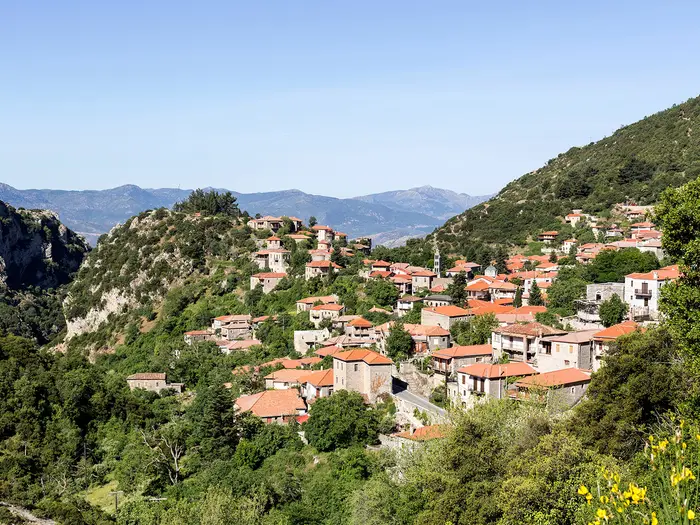
Image by TETYANA The Menalon Trail is a compact but rewarding mountain traverse across Arcadia in the central Peloponnese, linking Stemnitsa (Στεμνίτσα) with Lagkadia (Λαγκάδια) over 75 km of waymarked paths. It suits hikers who want a village-to-village Greek mountain walk without technical terrain, but with enough climbing, stone paths and rough ground to feel like a proper multi-day route.
The opening section drops into the Lousios gorge (Λούσιος), where forest, river, steep rock and cliff-side monasteries make an immediate impression. From there the trail climbs through Dimitsana (Δημητσάνα), the fir forests of Mt Mainalo (Μαίναλο), the Mylaon river (Μυλάων) valley and a chain of high Arcadian villages.
This is not a hut trek: nights are in guesthouses and small hotels in places such as Dimitsana, Vytina (Βυτίνα), Magouliana (Μαγουλιάνα), Valtesiniko (Βαλτεσινίκο) and Lagkadia. That village structure is one of the trail’s strengths, but it also means accommodation and local transport need more planning than the distance suggests.
The walking is consistently waymarked with yellow/black ERA blazes and is non-technical, yet the full route is still a moderate mountain journey. Expect steep stone-paved climbs and descents, a low gorge section around 420 m, higher ground reaching about 1,550 m, and roughly 3,200 m of cumulative ascent across the traverse.
This guide covers stages, days, accommodation, food, transport, terrain and common mistakes.
Stage-by-Stage Guide
The notes below follow the eight official Menalon Trail sections and their official distances. They are planning notes rather than turn-by-turn instructions: the trail is waymarked with yellow/black blazes, but a map or offline GPS track is still sensible, especially in forest, gorge and poor-weather conditions.
Stage 1: Stemnitsa (Στεμνίτσα) to Dimitsana (Δημητσάνα) — 12.5 km
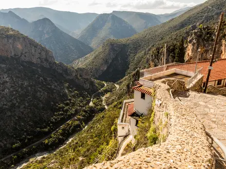
This is the most dramatic opening stage of the route, dropping from the mountain village of Stemnitsa into the Lousios gorge (Λούσιος) before climbing towards Dimitsana. It includes the lowest part of the whole trail, around 420 m, and feels more rugged than the distance suggests.
The walking is on old stone-paved mule paths, rocky footpaths and shaded gorge-side tracks. Expect steep descents and climbs, with some uneven stone underfoot, especially where the path enters and leaves the gorge.
The key landmarks are the cliff-side Prodromou Monastery (Μονή Τιμίου Προδρόμου) and the Philosophou Monastery (Μονή Φιλοσόφου), including the older monastic site partly hidden in the rock. These make this stage one of the cultural and scenic highlights of the entire trail.
Food and water: start with enough water and food for the full stage rather than relying on the gorge. Stemnitsa and Dimitsana are both larger trail villages, but opening hours and seasonal availability should be checked before travelling.
Accommodation: Dimitsana is one of the principal overnight stops on the Menalon Trail, with village guesthouses and small hotels. It is a sensible place to book early, especially in popular spring and autumn periods.
Access and transport: both Stemnitsa and Dimitsana are reached by road via Tripoli, with limited local KTEL Arcadia bus options and taxis or transfers often used by walkers. Current bus timetables should be checked before travelling.
Navigation and warnings: the gorge section needs more care than a simple village path. The route is waymarked, but side paths around monasteries and steep stone sections make concentration important. In hot weather, the climb out of the gorge can feel strenuous; after rain, stone paving and rock can be slippery.
Stage 2: Dimitsana (Δημητσάνα) to Zygovisti (Ζυγοβίστι) — 4.2 km
This is the shortest official section, often used as a half-day or combined with another stage by fit walkers. It still belongs to the same mountain walking route, so it should not be treated as an urban transfer.
As the route leaves Dimitsana it passes the Open-Air Water Power Museum (Υπαίθριο Μουσείο Υδροκίνησης), which explains the restored watermills, tannery and gunpowder mill linked to Dimitsana’s role in the 1821 Greek War of Independence. Beyond the village edge, expect the usual Menalon mix of old paths, stone paving, dirt and rocky surfaces.
Zygovisti is a smaller settlement than Dimitsana. This makes the stage logistically simple on paper but important to plan carefully if sleeping there.
Food and water: Dimitsana is the best place to organise food and water before starting. Do not assume reliable food supplies at Zygovisti without checking ahead.
Accommodation: Zygovisti has fewer and less reliable overnight options than the larger villages. Accommodation should be booked in advance, and a fallback plan is sensible if walking outside the main season.
Access and transport: Dimitsana has road access and is one of the easier trail villages to use as a starting or joining point. Zygovisti also has road access, but public transport should not be assumed; taxis or pre-arranged transfers may be needed. This should be checked before travelling.
Navigation and warnings: despite the short distance, keep following the official yellow/black Menalon Trail markings rather than assuming all paths out of Dimitsana lead towards Zygovisti. This stage is useful for adjusting the itinerary, but combining it with Stage 3 creates a much longer day.
Stage 3: Zygovisti (Ζυγοβίστι) to Elati (Ελάτη) — 14.9 km
This is one of the longer official sections and a proper mountain day across the western slopes of Mt Mainalo (Μαίναλο). The character changes from gorge-and-village walking to deeper Arcadian highland terrain, with extensive fir forest and quieter paths.
The surface is a mixture of rocky footpath, dirt track, old stone-paved route and forest walking. The central Menalon stages include some of the higher ground on the route, so conditions can feel cooler and more exposed than the lower villages suggest.
The main highlight is the Mt Mainalo fir forest itself. Views may open from higher ground and pasture sections, but much of the experience is shaded, enclosed mountain woodland.
Food and water: carry food and enough water for the full stage. Zygovisti and Elati are smaller villages, and intermediate services should not be relied on.
Accommodation: Elati has fewer and less reliable accommodation options than Stemnitsa, Dimitsana, Vytina or Lagkadia. Book ahead and confirm that the accommodation is open on the required date.
Access and transport: both villages are road-accessible, but this section should be planned as a walking stage rather than something easy to leave by public transport. Local buses in the wider area are sparse; taxis or booked transfers are more realistic if needing to start or finish here. This should be checked before travelling.
Navigation and warnings: forest sections can make distance and direction harder to judge, even on a marked trail. Keep an offline map available and pay attention at track junctions. In winter or early spring, higher ground may be affected by cold conditions or snow; high-summer heat can still be an issue on open sections.
Stage 4: Elati (Ελάτη) to Vytina (Βυτίνα) — 8.5 km
This is a shorter forest stage leading into Vytina, one of the most useful overnight and resupply bases on the trail. It works well as a moderate day after the longer Zygovisti–Elati section.
The terrain remains typical of the Mainalo forest stages: fir woodland, old tracks, rocky path and patches of stone-paved mule route. The walking is non-technical, but the surface is uneven enough to justify proper hiking footwear.
Vytina is a well-known Arcadian mountain resort village set in fir forest and is a practical halfway base for many itineraries. It is one of the more comfortable places on the route to pause, reorganise kit or adjust the schedule.
Food and water: leave Elati with enough water for the stage. Vytina is a more dependable place than the smaller villages for food and general trail services, but seasonal opening should still be checked.
Accommodation: Vytina has a better range of village-based accommodation than the smaller settlements. Advance booking is still recommended in spring and autumn, and especially if arriving at a weekend or during local holiday periods.
Access and transport: Vytina has road access and is one of the more logical places to join, leave or break the trail by taxi or transfer. Public transport in the Gortynia highlands remains limited, so current KTEL Arcadia options should be checked before planning around buses.
Navigation and warnings: the stage is generally straightforward by Menalon standards, but forest junctions still require attention to the blazes. Wet stone and leaf-covered rock can be slippery after rain.
Stage 5: Vytina (Βυτίνα) to Nymfasia (Νυμφασία) — 5.6 km
This is a short but rewarding section on the Old Vytina footpath, moving from the village towards the Mylaon river (Μυλάων). It is a good example of how the Menalon Trail links villages through historic local paths rather than simply following roads.
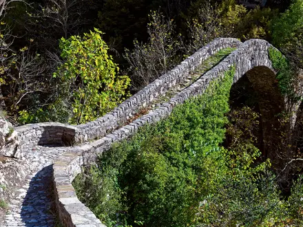
The stage includes river-side walking and passes the Mavra Litharia limestone boulders in the riverbed before reaching the Tzavarena Bridge (Γεφύρι της Τζαβαρένας), a single-arch stone bridge dating from 1868. The Mylaon valley gives the stage a more intimate, watercourse feel after the forested Mainalo sections.
Because the distance is short, many walkers combine it with the following stage. That is practical for fit walkers, but the next section continues into higher ground towards Magouliana.
Food and water: Vytina is the best place to organise food and water before starting. Nymfasia is smaller, so do not depend on finding open services there without checking in advance.
Accommodation: Nymfasia has fewer and less reliable accommodation options than Vytina. Booking ahead is important if ending the day here.
Access and transport: Vytina is a practical road-access point; Nymfasia is also reached by road, but public transport should not be assumed. This should be checked before travelling.
Navigation and warnings: pay attention where the path follows or approaches the Mylaon river corridor, especially after rain when rock, mud and river-side surfaces can be slick. No river crossing should be improvised if conditions look unsafe; stay on the marked trail.
Stage 6: Nymfasia (Νυμφασία) to Magouliana (Μαγουλιάνα) — 8.9 km
This stage climbs into the north-eastern Gortynian mountain country and finishes at Magouliana, at about 1,360 m the highest village on the Menalon Trail and one of the highest in the Peloponnese. It is a shorter official section than the longest days, but the high finish makes it feel like a real mountain stage.
Expect a mixture of rocky path, dirt, old mule routes, forest and more open highland terrain. As the route rises, weather exposure becomes more relevant than in the lower river valleys.
The main reward is the arrival at Magouliana, with wide views over the Mainalo range. This is one of the best places on the trail to feel the elevation of the Arcadian highlands.
Food and water: carry sufficient food and water from Nymfasia. Magouliana is a small high village, so food availability and opening times should be checked before travelling.
Accommodation: Magouliana has fewer and less reliable beds than the larger trail villages. Book accommodation before committing to this as an overnight stop.
Access and transport: road access exists, but this is not a section to plan around spontaneous public transport. Pre-arranged taxi or transfer options may be needed. This should be checked before travelling.
Navigation and warnings: higher sections can be exposed to sun, wind and cold depending on season. Avoid high-summer heat and do not treat winter snow on the higher parts of the Menalon Trail casually. Carry a warm layer even in otherwise mild walking seasons.
Stage 7: Magouliana (Μαγουλιάνα) to Valtesiniko (Βαλτεσινίκο) — 6.6 km
This is a short official section between two highland villages. The modest distance can be useful for itinerary spacing, but the terrain remains mountainous rather than lowland easy walking.
The route continues through the Gortynian uplands on the Menalon Trail’s usual mix of rocky footpaths, dirt tracks and old stone-paved ways. Expect changes between wooded and more open ground, with the feel of a high village-to-village crossing.
The stage is less defined by a single landmark than by its setting: high Arcadian villages, mountain air and the transition westwards towards the final approach to Lagkadia.
Food and water: carry water and food for the full section. Both Magouliana and Valtesiniko are smaller villages, so do not rely on finding open food services without checking ahead.
Accommodation: Valtesiniko has fewer and less reliable accommodation options than the larger route villages. Advance booking is strongly advised if sleeping there.
Access and transport: both ends are road-accessible, but local public transport is limited in this part of Arcadia. Any plan to join, leave or skip this section by road should be arranged in advance. This should be checked before travelling.
Navigation and warnings: the short distance makes this stage easy to underestimate, particularly if it follows a long previous day or is combined with the final stage. Keep to the marked route and allow for slower progress on rough stone or rocky ground.
Stage 8: Valtesiniko (Βαλτεσινίκο) to Lagkadia (Λαγκάδια) — 13.9 km
The final official section is a substantial last day to Lagkadia, the amphitheatrically built stone village that marks the western end of the Menalon Trail. It should be treated as a full walking day, not simply a short approach to the finish.
The terrain remains consistent with the wider route: old mule paths, stone-paved sections, rocky footpath, dirt and mountain village approaches. The walking is non-technical but still demanding after several days of accumulated ascent and descent.
The key highlight is the finish in Lagkadia, a western Gortynia stone village traditionally associated with master stonemasons. Its steep, amphitheatrical setting makes it a memorable end point for the traverse.
Food and water: leave Valtesiniko with enough food and water for the full stage. Lagkadia is one of the larger accommodation villages on the route, but onward travel and services should be checked before arrival.
Accommodation: Lagkadia has village-based guesthouses and small hotels and is the natural overnight stop at the end of the trail. Booking ahead is still sensible, particularly if onward transport is limited the same day.
Access and transport: leaving Lagkadia usually means travelling by road to Tripoli and then onward by KTEL coach, or using a pre-booked taxi or transfer. Local buses are limited and do not run as frequently as intercity services from Tripoli. Current KTEL Arcadia timetables should be checked before travelling.
Navigation and warnings: fatigue is the main practical issue on the last stage, especially if stages have been combined earlier in the walk. Keep enough daylight for the full 13.9 km, continue following the yellow/black blazes into Lagkadia, and avoid assuming that the final day will be easy simply because the route is near its end.
Recommended Itinerary
All distances below use the official Menalon Trail section figures. Where two or more official sections are combined, the distance is the sum of those sections.
Standard itinerary: 6 days
This is the most practical balance for reasonably fit walkers: it keeps the Lousios gorge as its own day, uses Vytina (Βυτίνα) as a strong halfway base, and avoids turning every short official section into a separate overnight. The trade-off is a long second day from Dimitsana (Δημητσάνα) to Elati (Ελάτη), so book Elati accommodation before committing to this plan.
| Day | From | To | Approx. distance | Why this stage makes sense | Services/accommodation notes |
|---|---|---|---|---|---|
| 1 | Stemnitsa (Στεμνίτσα) | Dimitsana (Δημητσάνα) | 12.5 km | Keeps the dramatic Lousios gorge section together, with time for the cliff-side Prodromou and Philosophou monasteries before climbing to Dimitsana. | Dimitsana is one of the main accommodation villages on the trail, with guesthouses and small hotels. Book ahead, especially outside the main walking season when openings can be less predictable. |
| 2 | Dimitsana (Δημητσάνα) | Elati (Ελάτη), via Zygovisti (Ζυγοβίστι) | 19.1 km | Combines the very short Dimitsana–Zygovisti section with the longer forest stage to Elati, avoiding a 4.2 km walking day. This is the longest day in the standard plan. | Elati is a smaller settlement, so accommodation should be arranged in advance. If this day feels too long, split it at Zygovisti. |
| 3 | Elati (Ελάτη) | Vytina (Βυτίνα) | 8.5 km | A shorter day after the long Mainalo forest stage, finishing in one of the best-served villages on the route. | Vytina is a popular Arcadian mountain resort and a useful halfway base with a better choice of places to stay than the smaller villages. |
| 4 | Vytina (Βυτίνα) | Magouliana (Μαγουλιάνα), via Nymfasia (Νυμφασία) | 14.5 km | Combines the short Vytina–Nymfasia section with the climb towards Magouliana, the highest village on the trail. | Magouliana has fewer and less reliable accommodation options than Vytina, Dimitsana or Lagkadia. Book this night before setting out. |
| 5 | Magouliana (Μαγουλιάνα) | Valtesiniko (Βαλτεσινίκο) | 6.6 km | A deliberately short mountain-village day, useful for recovering before the longer final stage to Lagkadia. | Valtesiniko is a smaller overnight stop; do not rely on finding a room on arrival. |
| 6 | Valtesiniko (Βαλτεσινίκο) | Lagkadia (Λαγκάδια) | 13.9 km | Finishes with the full official final section into Lagkadia, the western end of the trail. | Lagkadia is one of the larger villages on the route and the logical final overnight before onward road transport. Check onward KTEL or taxi arrangements before travelling. |
Slower variant: 8 official sections
The 8-day version follows the trail exactly as divided into its official daily sections. It suits walkers who want shorter days, more time in villages, and a lower-risk schedule in warm weather or with a heavier pack.
| Day | From | To | Approx. distance | Why this stage makes sense | Services/accommodation notes |
|---|---|---|---|---|---|
| 1 | Stemnitsa (Στεμνίτσα) | Dimitsana (Δημητσάνα) | 12.5 km | The full Lousios gorge day, with the main monasteries and the lowest part of the route. | Dimitsana has one of the better accommodation selections on the trail. |
| 2 | Dimitsana (Δημητσάνα) | Zygovisti (Ζυγοβίστι) | 4.2 km | A very short day, useful if you want time for Dimitsana and the Open-Air Water Power Museum as the route leaves town. | Zygovisti is a small village; pre-book accommodation or adjust the itinerary. |
| 3 | Zygovisti (Ζυγοβίστι) | Elati (Ελάτη) | 14.9 km | Puts the longer Mainalo forest stage on a fresh day rather than adding it to the walk out of Dimitsana. | Elati has fewer accommodation options than the larger villages. Book ahead. |
| 4 | Elati (Ελάτη) | Vytina (Βυτίνα) | 8.5 km | A moderate day into a well-served midpoint village. | Vytina is a useful place for a more comfortable overnight and any resupply available locally. |
| 5 | Vytina (Βυτίνα) | Nymfasia (Νυμφασία) | 5.6 km | A short stage on the Old Vytina footpath, including the Mylaon river area and Tzavarena Bridge. | Nymfasia is a smaller settlement; accommodation availability should be checked before travelling. |
| 6 | Nymfasia (Νυμφασία) | Magouliana (Μαγουλιάνα) | 8.9 km | A manageable climb to the highest village on the route, with no need to rush the higher ground. | Magouliana is high and small; book in advance. |
| 7 | Magouliana (Μαγουλιάνα) | Valtesiniko (Βαλτεσινίκο) | 6.6 km | Another short day, keeping the final approach to Lagkadia for its own stage. | Valtesiniko has limited accommodation; confirm the overnight before relying on this split. |
| 8 | Valtesiniko (Βαλτεσινίκο) | Lagkadia (Λαγκάδια) | 13.9 km | Completes the official final section into the stone-built endpoint village. | Lagkadia is the end of the route; arrange onward transport to Tripoli or elsewhere in advance. |
Faster variant: 5 days
A 5-day itinerary suits fit hikers carrying light packs who are comfortable with long mountain days and pre-booked accommodation. It keeps overnight stops in the more useful larger villages where possible, but Day 4 is long and should not be underestimated.
| Day | From | To | Approx. distance | Why this stage makes sense | Services/accommodation notes |
|---|---|---|---|---|---|
| 1 | Stemnitsa (Στεμνίτσα) | Dimitsana (Δημητσάνα) | 12.5 km | Keeps the gorge, monasteries and climb to Dimitsana as a self-contained first day. | Dimitsana is a practical first overnight with better accommodation choice. |
| 2 | Dimitsana (Δημητσάνα) | Elati (Ελάτη), via Zygovisti (Ζυγοβίστι) | 19.1 km | Combines the short second official section with the longer forest stage, making meaningful progress across Mt Mainalo. | Elati is small; this night must be booked ahead. |
| 3 | Elati (Ελάτη) | Vytina (Βυτίνα) | 8.5 km | A shorter recovery day into a well-served halfway village before the longest combined day. | Vytina is the best place on this fast schedule for a more secure overnight and local services. |
| 4 | Vytina (Βυτίνα) | Valtesiniko (Βαλτεσινίκο), via Nymfasia (Νυμφασία) and Magouliana (Μαγουλιάνα) | 21.1 km | Combines three shorter official sections into one demanding day over the north-eastern part of the route. | Valtesiniko accommodation is limited; do not attempt this stage without a confirmed bed or onward plan. |
| 5 | Valtesiniko (Βαλτεσινίκο) | Lagkadia (Λαγκάδια) | 13.9 km | Leaves the final official section intact and finishes in Lagkadia. | Lagkadia is the endpoint. Check current KTEL Arcadia timetables or pre-book a taxi/transfer before relying on public transport. |
A 4-day traverse is possible only for very strong walkers prepared to combine several mountain sections back to back. For most independent hikers, the 6-day plan is the better default, with the 8-day version the safest choice if accommodation in smaller villages lines up cleanly.
Planning the Route
The Menalon Trail is easiest to plan as a village-to-village walk, not as a wilderness trek. The route is divided into 8 official sections between 9 settlements, and those villages largely dictate where nights can sensibly be spent.
Most independent walkers should allow 5–6 days. A 4-day crossing is possible for fit hikers who are comfortable combining sections, but it leaves less margin for heat, transport delays, short-service villages and the steeper gorge and forest climbs. The full 8-section schedule is relaxed in places because two official sections are short, but it gives the most time for the Lousios gorge, Dimitsana and the Mainalo forest stages.
Choosing a pace
The trail can be walked quickly, but it generally suits a measured pace. The scenery and logistics both favour allowing time: the Lousios gorge comes early, accommodation is village-based, and local transport at either end is limited enough that missed connections can be awkward.
| Pace | Who it suits | Planning implications |
|---|---|---|
| 8 official sections | Walkers who want short days and maximum village time | Follows the trail structure exactly, but requires accommodation in smaller villages where options can be fewer. Book ahead. |
| 5–6 days | Most reasonably fit walkers | Combines some shorter sections while keeping daily distances manageable. This is usually the best balance of walking time and logistics. |
| 4 days | Strong walkers with light packs and firm bookings | Requires long combined days and leaves little spare time. Transport and accommodation should be fixed before arrival. |
| 3 days | Very fit fastpackers only | Possible only by combining multiple official sections per day. It is not the most forgiving way to experience the route. |
The official stages vary a lot in length. Dimitsana (Δημητσάνα) to Zygovisti (Ζυγοβίστι) is only 4.2 km, and Vytina (Βυτίνα) to Nymfasia (Νυμφασία) is 5.6 km, so these are the natural sections to combine with adjacent days if reducing the itinerary.
Official section structure
These are the official village-to-village sections to use when building an itinerary:
| Section | Route | Official distance | Planning note |
|---|---|---|---|
| 1 | Stemnitsa (Στεμνίτσα) to Dimitsana (Δημητσάνα) | 12.5 km | The Lousios gorge section, with steep descent and ascent and the lowest part of the route. Do not treat it as a simple warm-up. |
| 2 | Dimitsana to Zygovisti (Ζυγοβίστι) | 4.2 km | A short section often combined with Section 3 by faster walkers. |
| 3 | Zygovisti to Elati (Ελάτη) | 14.9 km | One of the longer central mountain stages through the Mainalo area. |
| 4 | Elati to Vytina (Βυτίνα) | 8.5 km | Ends in one of the larger and more practical overnight stops. |
| 5 | Vytina to Nymfasia (Νυμφασία) | 5.6 km | Short, and commonly paired with either the previous or next section. |
| 6 | Nymfasia to Magouliana (Μαγουλιάνα) | 8.9 km | Climbs towards the highest village on the trail. |
| 7 | Magouliana to Valtesiniko (Βαλτεσινίκο) | 6.6 km | Another shorter section, but still in highland terrain. |
| 8 | Valtesiniko to Lagkadia (Λαγκάδια) | 13.9 km | The final point-to-point day into western Gortynia. |
Sensible itinerary shapes
A 6-day itinerary gives a good balance if beds are available in the smaller villages. It normally means combining some of the short middle sections while still avoiding very long days.
A 5-day itinerary is the most efficient plan for many fit walkers. A common pattern is to combine Dimitsana–Zygovisti with Zygovisti–Elati, combine Elati–Vytina with Vytina–Nymfasia, and combine Nymfasia–Magouliana with Magouliana–Valtesiniko. This creates fuller days without straying from the official route.
A 4-day itinerary needs careful thought because the route is not just a distance problem. The steep stone-paved climbs and descents, the Lousios gorge, the high ground around Mt Mainalo (Μαίναλο) and possible heat all make long days more demanding than the kilometre figures suggest.
Accommodation drives the plan
There is no mountain-hut system on the Menalon Trail. Nights are planned around guesthouses and small hotels in the villages, with the most reliable choice generally in Stemnitsa, Dimitsana, Vytina and Lagkadia.
Smaller settlements such as Zygovisti, Elati, Nymfasia, Magouliana and Valtesiniko have fewer and less reliable options. If an itinerary depends on one of these overnight stops, accommodation should be booked before committing to that day structure, especially outside the main walking season.
Do not assume that every village will have flexible same-day availability. The trail works best when each night is fixed in advance, then transport is arranged around those bookings.
Food and water planning
This is a village-based trail, so food planning is different from a hut-to-hut route. Carry enough food for the walking day, especially when linking smaller villages or combining sections.
Services in the smaller settlements should not be assumed, particularly out of season. Evening meals, packed lunches and breakfast arrangements are best checked with accommodation before arrival.
No reliable water strategy should depend on finding water between villages unless current local information is available. Start each day with enough water for the whole stage, and carry extra in warm weather, on exposed higher ground and when walking the longer combined days.
Navigation and route-finding
The Menalon Trail is consistently waymarked with yellow-and-black ERA blazes, and the signing is one of its strengths. Even so, an offline map or GPX track is sensible because the route uses old mule paths, stone-paved tracks, forest paths, river sections and village lanes.
Do not rely only on phone signal. The forested Mainalo sections and the Lousios gorge are exactly the places where a pre-downloaded map is most useful.
Transport affects both ends of the walk
Transport is one of the main planning constraints. The trail is reached by road via Tripoli (Τρίπολη), with onward travel to Stemnitsa or Dimitsana by limited local KTEL Arcadia bus or taxi.
Local buses beyond Tripoli run only on certain weekdays, with no service on some days. Leaving Lagkadia is similar: either use a limited local bus back towards Tripoli or arrange a pre-booked transfer or taxi. Current KTEL timetables should be checked before travelling.
Because there is no railway serving the trail, it is safer to plan the first and last travel days before booking accommodation. A late arrival in Tripoli may make a taxi the practical option for reaching the start.
Shortening, extending and section hiking
The route can be shortened by walking selected village-to-village sections, but public transport makes casual section hiking awkward. In practice, section walking usually needs taxis, pre-arranged transfers or careful alignment with the limited local bus timetable.
Dimitsana and Vytina are the most practical places to build a shorter trip around because they are among the larger villages on the route. However, any plan that skips sections or starts mid-trail should be built around confirmed transport, not just the map.
Extending the walk is mainly a matter of adding rest days in villages rather than adding official trail mileage. Dimitsana is the obvious place to slow down if time allows, while Vytina is a practical halfway stop before the north-eastern Gortynian stages.
Weather and seasonal planning
Spring and autumn are the best planning windows. High summer heat can make the exposed climbs and gorge sections unpleasant, while winter conditions can affect the higher parts of the route, which reach about 1,550 m.
Daily plans should leave margin for heat, storms or poor visibility in the forest and high pasture sections. Starting early is sensible in warm conditions, especially on longer combined stages.
Permits are not the main planning issue on this trail; beds, water, transport and weather matter more. Any current access requirements or local restrictions should be checked before travelling.
Towns, Villages and Overnight Stops
The Menalon Trail is a village-to-village walk, not a hut trek. Overnight planning revolves around the nine settlements on the official route: larger bases such as Stemnitsa, Dimitsana, Vytina and Lagkadia are generally the most practical, while Zygovisti, Elati, Nymfasia, Magouliana and Valtesiniko need more careful advance booking.
Do not assume that every small village will have available beds, evening food or an open shop on arrival, especially outside the main walking seasons. Contact accommodation directly before committing to an itinerary, and check meal options at the same time.
| Place | Route position | Practical role for hikers |
|---|---|---|
| Stemnitsa (Στεμνίτσα) | Official start | Best starting base before the Lousios gorge stage |
| Dimitsana (Δημητσάνα) | End Section 1 / start Section 2 | Principal trail town; strong overnight and logistics base |
| Zygovisti (Ζυγοβίστι) | End Section 2 / start Section 3 | Small stop after a short stage; book carefully |
| Elati (Ελάτη) | End Section 3 / start Section 4 | Useful forest-stage overnight; limited services |
| Vytina (Βυτίνα) | End Section 4 / start Section 5 | Popular halfway base with better services |
| Nymfasia (Νυμφασία) | End Section 5 / start Section 6 | Small overnight stop; confirm beds and food |
| Magouliana (Μαγουλιάνα) | End Section 6 / start Section 7 | High village stop at about 1,360 m |
| Valtesiniko (Βαλτεσινίκο) | End Section 7 / start Section 8 | Practical final-night stop before Lagkadia |
| Lagkadia (Λαγκάδια) | Official finish | End-of-trail base; arrange onward transport in advance |
Stemnitsa (Στεμνίτσα)
Stemnitsa is the official trailhead and the start of Section 1 to Dimitsana. It sits at roughly 1,000 m on the western slope above the Lousios (Λούσιος) gorge, so it is a sensible place to arrive the day before walking rather than trying to combine travel and the first stage.
Accommodation is village-based, with family-run guesthouses and small hotels among the more reliable options on the trail. Book ahead in spring and autumn, and also out of season when some places may not be operating normally.
Food and basic supplies should be sorted before setting off into the gorge, as Section 1 descends into one of the more committing parts of the route. Check with the guesthouse whether breakfast, packed food or an early start is possible.
Access is by road via Tripoli (Τρίπολη). Local KTEL Arcadia buses towards Stemnitsa are infrequent and do not run every weekday, so current timetables should be checked before travelling; a taxi or pre-booked transfer from Tripoli is often the simpler option.
Dimitsana (Δημητσάνα)
Dimitsana is the end of Section 1 from Stemnitsa and the start of the short Section 2 to Zygovisti. It is the principal town on the Menalon Trail and one of the most useful places for accommodation, food and itinerary flexibility.
This is one of the best overnight stops on the route. It has a stronger choice of guesthouses and small hotels than the smaller trail villages, making it a good place to recover after the Lousios gorge stage or to build in a slower first two days.
The Open-Air Water Power Museum lies on the route as Section 2 leaves Dimitsana, so walkers with time may prefer not to rush straight through. Dimitsana also works well as a practical access point if starting with a shortened itinerary, as road access from Tripoli is part of the normal approach to the area.
Local public transport remains limited. Buses between Tripoli and the mountain villages run only on certain days, and taxi or transfer arrangements should be made in advance if relying on a fixed schedule.
Zygovisti (Ζυγοβίστι)
Zygovisti is reached after the short official Section 2 from Dimitsana, about 4.2 km. It marks the start of the longer Section 3 to Elati, which heads into the Mt Mainalo (Μαίναλο) forest country.
As a small settlement, Zygovisti has fewer and less reliable accommodation options than Dimitsana or Vytina. Treat it as a booked overnight stop, not a place to arrive speculatively and look for a room.
Because the approach from Dimitsana is short, some fit walkers combine Section 2 with another stage. That can make sense logistically if accommodation or food in Zygovisti is not available, but it creates a longer mountain day and should be planned with the next section’s distance and ascent in mind.
Food, café and shop availability should be checked directly with the accommodation before travelling. Do not rely on local buses for a quick exit from Zygovisti without checking current services.
Elati (Ελάτη)
Elati is the end of Section 3 from Zygovisti, after about 14.9 km, and the start of Section 4 to Vytina. It is a useful stop for keeping to the official eight-section structure, particularly after the longer central forest stage.
Accommodation is more limited here than in the larger villages. Booking ahead is strongly advised, and walkers should also ask whether an evening meal and breakfast are available.
Elati’s value is mainly logistical: it breaks the high, wooded Mainalo part of the trail into manageable sections. Skipping it normally means creating a much longer day across the central part of the route.
Road access exists, but public transport details for the smaller villages are not dependable enough to assume. This should be checked before travelling.
Vytina (Βυτίνα)
Vytina is reached at the end of Section 4 from Elati and is a popular halfway base on the Menalon Trail. It is a well-known Arcadian mountain resort village set in fir forest, and it is one of the easier places on the route for accommodation and services.
This is a good place to plan a slightly more comfortable overnight, a rest, or a resupply check before continuing into the Mylaon (Μυλάων) river valley stages. Guesthouses and small hotels are generally more available here than in the smaller settlements, though advance booking is still sensible.
Section 5 from Vytina to Nymfasia is short, about 5.6 km, following the Old Vytina footpath and passing the Mavra Litharia limestone boulders and Tzavarena Bridge. Because the next official stage is short, some walkers use Vytina to adjust the itinerary, either by taking an easier day or combining stages if accommodation in Nymfasia is not practical.
Transport is by road only. Any bus connection should be checked before travelling, and a taxi or pre-arranged transfer may be needed if joining or leaving the route here.
Nymfasia (Νυμφασία)
Nymfasia is the end of the short Section 5 from Vytina and the start of Section 6 to Magouliana. It is a small overnight stop rather than a major logistics base.
Accommodation and food options are fewer and less reliable than in Vytina. Book the night in advance and confirm whether dinner, breakfast and any packed food can be provided.
Nymfasia is useful if following the official sections, as it keeps the climb towards Magouliana to a separate day. If beds or meals are not available, combining Vytina–Nymfasia with the onward stage to Magouliana may be considered by fit walkers, but that creates a much longer day.
Do not rely on spontaneous public transport from Nymfasia. This should be checked before travelling.
Magouliana (Μαγουλιάνα)
Magouliana is the end of Section 6 from Nymfasia and sits at about 1,360 m, making it the highest village on the Menalon Trail and one of the highest in the Peloponnese. It is a memorable stop, but a small one.
Accommodation should be arranged before arrival. As with the other smaller settlements, confirm food availability directly with the place where you are staying, particularly outside the main spring and autumn walking periods.
Its height makes it a practical weather checkpoint. Conditions can feel very different here from the lower Lousios gorge, and the higher sections of the trail should be treated seriously in poor weather or any risk of winter snow.
Section 7 from Magouliana to Valtesiniko is about 6.6 km, so staying here gives a relatively short onward day. Transport options should not be assumed without checking current local arrangements.
Valtesiniko (Βαλτεσινίκο)
Valtesiniko is the end of Section 7 from Magouliana and the start of the final Section 8 to Lagkadia. It is the key final-night stop if walking the trail as the official eight-section itinerary.
Accommodation is more limited than in the main trail towns, so pre-booking is important. Confirm evening food and breakfast before arrival, as the final stage to Lagkadia is about 13.9 km and should not start with uncertain supplies.
Valtesiniko is especially useful for keeping the last day manageable. Skipping it means changing the balance of the final part of the route and may create an unnecessarily long day through the north-western Gortynian mountains.
Local transport should be treated as limited. This should be checked before travelling.
Lagkadia (Λαγκάδια / Langadia)
Lagkadia is the official finish of Section 8 and the end of the Menalon Trail. It is an amphitheatrically built stone village in western Gortynia, traditionally associated with master stonemasons, and it sits at a similar high elevation to the start at Stemnitsa.
As one of the larger settlements on the route, Lagkadia is a practical place to spend the final night rather than trying to leave immediately after finishing. This is particularly sensible because onward transport is limited and may not line up neatly with walking times.
Accommodation is generally more reliable here than in the smaller intermediate villages, but booking ahead is still recommended. Confirm meal times if arriving late after the final stage from Valtesiniko.
Leaving Lagkadia is by road. Local buses to Tripoli are limited, with onward KTEL coaches from Tripoli to Athens, or you can arrange a taxi or pre-booked transfer; there is no railway serving the trail. Current KTEL Arcadia timetables should be checked before relying on buses.
Getting to the Start
The Menalon Trail starts in Stemnitsa (Στεμνίτσα), a mountain village above the Lousios gorge. Access is by road, normally via Tripoli (Τρίπολη), the regional transport hub for Arcadia.
Public transport beyond Tripoli is limited, so the main planning decision is whether to rely on the infrequent local KTEL Arcadia bus or book a taxi/transfer for the final leg to Stemnitsa.
By train
There is no railway serving Stemnitsa, Lagkadia or the Menalon Trail villages. Rail is not a practical way to reach the start.
Plan the journey by coach, car or taxi via Tripoli instead. This should be checked before travelling if using any wider Greek rail connection as part of a longer trip, but it will not remove the need for road transport into Gortynia.
By bus
The usual public-transport route is:
| Leg | Transport | Notes |
|---|---|---|
| Athens or Athens airport to Tripoli | KTEL coach | Frequent coaches; journey time is about 2–2.5 hours. |
| Tripoli to Stemnitsa or Dimitsana | Local KTEL Arcadia bus | Infrequent; services run only a few days per week and there is no service on some weekdays. |
| Tripoli to Stemnitsa by taxi | Taxi or pre-booked transfer | About 40 minutes from Tripoli to Stemnitsa. Useful when bus timings do not fit. |
KTEL timetables should be checked before travelling, especially for the Tripoli–Stemnitsa/Dimitsana leg. Do not assume there will be a same-day connection from Athens to the trailhead.
If a bus only works as far as Dimitsana (Δημητσάνα), arrange onward transport to Stemnitsa rather than starting the trail in the wrong village. Section 1 officially runs from Stemnitsa to Dimitsana through the Lousios gorge, so skipping Stemnitsa means missing the first official stage.
By car
Driving gives the simplest access to Stemnitsa and avoids the weak local bus timetable. The practical approach is to drive to the Arcadian highlands via Tripoli, then continue by road to Stemnitsa.
The drawback is that the Menalon Trail is point-to-point, finishing in Lagkadia (Λαγκάδια), not back at Stemnitsa. If leaving a vehicle at the start, plan the return from Lagkadia to Stemnitsa in advance by taxi, transfer or local bus via Tripoli where available.
Long-stay parking arrangements in Stemnitsa should be agreed with your accommodation or checked locally before leaving a vehicle for several days. This should be checked before travelling.
From the nearest airport
For most international hikers, Athens airport is the practical arrival point. From there, travel by KTEL coach to Tripoli, then continue to Stemnitsa by local KTEL Arcadia bus if the timetable works, or by taxi/transfer.
Allow margin in the schedule if landing the same day. The long-distance coach leg to Tripoli is straightforward, but the final rural connection into Gortynia is the weak link and may not run every day.
Where to stay before starting
Stemnitsa is the best place to stay before beginning the trail. It is the official trailhead and lets you start Section 1 directly, without needing a morning transfer.
Accommodation is village-based, with family-run guesthouses and small hotels in the larger trail villages including Stemnitsa, Dimitsana, Vytina and Lagkadia. Book ahead, particularly out of season, because the Menalon Trail has no mountain-hut network and beds in smaller villages are more limited.
If arriving late or if onward transport from Tripoli does not align, build in an extra night rather than forcing a tight connection to the trailhead. The first stage descends into the Lousios gorge and is not a section to start tired, late or without enough daylight.
Getting Home from the Finish
The Menalon Trail finishes in Lagkadia (Λαγκάδια / Langadia), a mountain village in western Gortynia. Leaving the finish is a road-only logistics problem: there is no railway at the trail end, local buses are limited, and most onward journeys route via Tripoli (Τρίπολη).
If using public transport, do not assume there will be a same-day connection after finishing Section 8 from Valtesiniko (Βαλτεσινίκο). Current KTEL Arcadia timetables should be checked before travelling, and a pre-booked taxi or an overnight stay in Lagkadia is the safer plan if arriving late.
By train
There is no railway serving Lagkadia or the Menalon Trail. Train-based plans are not practical for leaving the finish.
Use road transport instead: local KTEL bus or taxi/transfer from Lagkadia to Tripoli, then onward KTEL coach connections towards Athens or other Peloponnese destinations. Any rail connection would require a separate road journey first, so it should not be treated as part of the core trail logistics.
By bus
The usual public-transport route out is:
| Leg | Practical notes |
|---|---|
| Lagkadia (Λαγκάδια) to Tripoli (Τρίπολη) | Limited local KTEL Arcadia bus service; services run only on certain days and may not suit a late finish. This should be checked before travelling. |
| Tripoli to Athens | Frequent KTEL coach service, typically around 2–2.5 hours. Check current departure points and times before booking onward travel. |
Local buses beyond Tripoli are sparse compared with the main Athens–Tripoli coach corridor. Build the finishing day around the Lagkadia–Tripoli connection, not the other way round.
If a bus is available early the next morning, staying in Lagkadia after finishing is often simpler than trying to rush Section 8 and make an uncertain same-day departure. This also gives a buffer if the final day takes longer than expected.
By car/taxi
A pre-booked taxi or private transfer is the most reliable way to leave Lagkadia, especially outside the limited bus timetable. The practical destination is usually Tripoli, where there are onward KTEL coach links.
Arrange the pickup before starting the final stage from Valtesiniko, or ask accommodation in Lagkadia to help book a local taxi. Do not rely on finding an immediate taxi at the trail end without notice, particularly out of season.
For groups, a taxi/transfer can be a straightforward alternative to waiting for an infrequent bus. Confirm the fare in euros before booking.
From the nearest airport
The main practical airport for international travel is Athens Airport. From Lagkadia, the normal route is by road to Tripoli, then onward by KTEL coach towards Athens and the airport.
Because the first leg from Lagkadia to Tripoli is the weak point in the chain, avoid booking a tight same-day flight after finishing the trail. If flying out, either finish early, pre-book a transfer, or spend the night in Lagkadia or Tripoli and travel onward the next day.
KTEL times, airport connections and coach departure points can change, so these should be checked before travelling.
Where to stay at the finish
Lagkadia has village-based accommodation, including guesthouses and small hotels, and is one of the better places on the route to end with an overnight stop. Booking ahead is still sensible, especially outside the main walking seasons or if arriving on a weekend.
Staying in Lagkadia is recommended if:
- the final stage from Valtesiniko is being walked in the afternoon;
- there is no convenient same-day bus to Tripoli;
- a taxi or transfer has not been pre-arranged;
- onward travel involves a flight or a long coach journey the next day.
For a tighter schedule, consider arranging accommodation or onward transport before leaving Valtesiniko. Mobile signal and local availability should not be the deciding factors once the final stage is already under way.
Which Direction Should You Walk?
The Menalon Trail is best planned in its official direction: Stemnitsa (Στεμνίτσα) to Lagkadia (Λαγκάδια). This follows the numbered sequence of the 8 official sections, starts at the recognised trailhead, and matches the natural way most route notes, stage plans and accommodation sequences are organised.
Walking in reverse is perfectly possible in practical terms, but it adds a little friction. You will be working against the official stage order, and transport and accommodation still need just as much planning.
Standard direction: Stemnitsa to Lagkadia
This is the cleanest direction for most hikers. You begin with the most dramatic lowland feature of the trail, the Lousios gorge (Λούσιος), including the cliff-side monasteries near the Stemnitsa–Dimitsana section, then continue through Dimitsana, the Mainalo fir forests, Vytina and the higher Gortynian villages before finishing in Lagkadia.
It also gives a good accommodation rhythm. The first night is typically in Dimitsana (Δημητσάνα), one of the principal villages on the route, and Vytina (Βυτίνα) makes a useful mid-route base. The smaller places — Zygovisti, Elati, Nymfasia, Magouliana and Valtesiniko — still need booking ahead, especially out of season.
The finish at Lagkadia works well psychologically. It is a substantial stone village and a natural end point after the final Valtesiniko–Lagkadia section, rather than simply stopping because the waymarked line runs out.
Reverse direction: Lagkadia to Stemnitsa
Reverse walking can make sense if accommodation or a private transfer lines up better that way. It also saves the Lousios gorge for the end, which some walkers may prefer if they want the trail’s most famous section as a finale.
There is no major difficulty advantage in reversing the route. The start and finish villages sit at broadly similar high elevations, while the route still drops to about 420 m in the Lousios gorge and reaches about 1,550 m on the higher Mainalo sections. Whichever way you walk, expect steep stone-paved climbs and descents, with around 3,200 m of total ascent across the full trail.
The main drawback is logistical clarity. The trail’s 8 official sections are set out from Stemnitsa to Lagkadia, so reverse walkers need to be more careful when reading stage information, checking village order and timing accommodation.
Transport considerations
Transport does not strongly favour either direction. Both Stemnitsa and Lagkadia are reached by road via Tripoli (Τρίπολη), with onward travel by limited local KTEL Arcadia buses or by taxi/private transfer. There is no railway serving the trail.
Because local buses beyond Tripoli are infrequent and may not run every weekday, the practical decision often comes down to which end has the workable transfer on the dates required. Current KTEL timetables and taxi arrangements should be checked before travelling.
Recommendation
For a first full traverse, walk Stemnitsa to Lagkadia. It follows the official direction, gives the simplest stage planning, places strong accommodation villages at useful points, and finishes naturally in Lagkadia.
Walk in reverse only if it solves a specific booking or transport problem, or if saving the Lousios gorge for the final day is more important than following the official section order.
Accommodation Along the Route
The Menalon Trail is a village-to-village walk rather than a hut trek. Accommodation is based on family-run guesthouses and small hotels, with the best choice in Stemnitsa (Στεμνίτσα), Dimitsana (Δημητσάνα), Vytina (Βυτίνα) and Lagkadia (Λαγκάδια).
There is no mountain-hut network on the route, so each overnight stop needs to be planned as a booking, not as a turn-up-and-find-a-bed arrangement. This is especially important in the smaller intermediate villages, where accommodation is more limited and opening patterns can be less reliable outside the main walking periods.
| Place | Accommodation level | Best for | Notes |
|---|---|---|---|
| Stemnitsa (Στεμνίτσα) | Good | Night before starting the trail | One of the stronger accommodation villages. A practical place to arrive the day before Section 1, as onward public transport from Tripoli is limited. |
| Dimitsana (Δημητσάνα) | Good | First major overnight; buffer or shorter itinerary planning | The principal town on the trail and one of the best places for choice. Useful if adjusting plans around the short Dimitsana–Zygovisti section. |
| Zygovisti (Ζυγοβίστι) | Limited | Official Section 2 stop | A small village with fewer options. Because Dimitsana–Zygovisti is only 4.2 km, many fit walkers may choose to continue beyond Zygovisti if accommodation is awkward. |
| Elati (Ελάτη) | Limited | Overnight after the long Zygovisti–Elati forest section | Book before committing to an itinerary that stops here. If beds are unavailable, a taxi transfer or a revised stage plan may be needed. |
| Vytina (Βυτίνα) | Good | Mid-route base; rest or schedule reset | A lively Arcadian mountain resort village and one of the strongest accommodation points on the route. A good place to absorb delays or split/merge stages. |
| Nymfasia (Νυμφασία) | Limited | Official Section 5 stop | Accommodation is more limited. As Vytina–Nymfasia is only 5.6 km, some walkers combine this with the onward stage to Magouliana if fitness and bookings allow. |
| Magouliana (Μαγουλιάνα) | Limited | High-village overnight between Nymfasia and Valtesiniko | A small high-elevation village, so beds should be secured in advance. Do not assume last-minute availability. |
| Valtesiniko (Βαλτεσινίκο) | Limited | Last overnight before Lagkadia | Important to book ahead, as the final Valtesiniko–Lagkadia section is 13.9 km and there is no hut alternative en route. |
| Lagkadia (Λαγκάδια) | Good | Finish night and onward travel planning | One of the larger accommodation stops. Staying overnight can make onward travel easier, as local buses are limited and taxis/transfers should be arranged in advance. |
Where booking ahead matters most
Book the smaller villages first: Zygovisti, Elati, Nymfasia, Magouliana and Valtesiniko. These are the places most likely to shape the itinerary, because a full or closed guesthouse can force a longer walking day or a road transfer.
Stemnitsa, Dimitsana, Vytina and Lagkadia have a stronger accommodation base, but booking ahead is still sensible. Vytina is a well-known mountain resort village, and weekend or holiday availability may be tighter than on quiet weekdays. This should be checked before travelling.
Out of season, do not assume every guesthouse, taverna or small village service is operating daily. Confirm arrival time, meal availability and whether packed food can be arranged before setting off for the next stage.
Using stage combinations to solve awkward gaps
The official trail is divided into 8 sections, but the accommodation pattern does not always require 8 overnight stops. Several short sections can be combined by fit walkers, which is useful when beds are limited in the smaller villages.
Practical combinations include:
- Dimitsana to Elati via Zygovisti — combines the short 4.2 km Dimitsana–Zygovisti section with the 14.9 km Zygovisti–Elati stage, making a much longer day.
- Vytina to Magouliana via Nymfasia — combines the 5.6 km Vytina–Nymfasia section with the 8.9 km Nymfasia–Magouliana stage.
- Magouliana to Lagkadia via Valtesiniko — possible only for strong walkers comfortable with a long final mountain day, as this combines 6.6 km and 13.9 km sections.
These combinations should be judged against the trail’s cumulative ascent, steep stone-paved climbs and descents, and weather. A short distance on paper can still feel demanding on the Menalon Trail.
Taxis, transfers and luggage
Taxi or private transfer arrangements can help when accommodation is unavailable in a small village. A common solution is to sleep in a larger village and arrange transport back to the trail the next morning, but this should not be left to chance in the highlands of Gortynia. This should be checked before travelling.
There is no built-in hut-to-hut luggage system on the trail. If luggage transfer is required, arrange it directly through accommodation providers or local taxi/transfer contacts before the trip, and confirm each move in advance.
For most independent walkers, the simplest arrangement is to carry a light overnight pack and stay in village accommodation each night. The absence of huts means there is no need for camping gear if every bed is booked, but the itinerary depends on those bookings holding.
Camping and Wild Camping
The Menalon Trail is not a campsite-to-campsite route. It is designed and most sensibly walked as a village-to-village trail, using guesthouses and small hotels in Stemnitsa (Στεμνίτσα), Dimitsana (Δημητσάνα), Vytina (Βυτίνα), Lagkadia (Λαγκάδια) and, where available, the smaller intermediate villages.
There is no mountain-hut network on the route, and formal campsite provision should not be assumed in the trail villages. If camping is central to the plan, check current local options before travelling rather than arriving with the expectation of a pitch.
Wild camping
Wild-camping rules and any local restrictions in Gortynia should be checked before travelling and again locally. Do not pitch without permission on private land, cultivated ground, village edges, monastery land or near working religious sites such as Prodromou Monastery and Philosophou Monastery in the Lousios gorge.
The Lousios gorge section between Stemnitsa and Dimitsana is a poor choice for camping. It is steep, enclosed, culturally sensitive around the monasteries, and contains some of the most constrained terrain on the trail.
The higher forest and pasture sections around Mt Mainalo (Μαίναλο), particularly between Zygovisti (Ζυγοβίστι), Elati (Ελάτη), Vytina (Βυτίνα), Nymfasia (Νυμφασία), Magouliana (Μαγουλιάνα) and Valtesiniko (Βαλτεσινίκο), are more plausible for an emergency bivvy than the gorge or village approaches. That does not remove the need for local permission and a discreet, low-impact camp.
Does the route suit camping?
For most walkers, camping is more trouble than it is worth on the Menalon Trail. The official sections are built around village stops, several days are relatively short, and carrying a tent, sleeping system and extra food adds weight on a route with steep stone-paved climbs and descents.
Camping may make sense only for hikers who are deliberately travelling self-sufficiently, are comfortable with uncertain legal and practical arrangements, and have checked local rules in advance. Even then, keep a village accommodation back-up plan, especially outside the main walking seasons when smaller settlements can have fewer reliable services.
Water and cooking
Do not rely on river water as ready-to-drink water. The trail follows or crosses watercourses including the Lousios (Λούσιος) and Mylaon (Μυλάων), but any natural water used for drinking should be treated, and availability away from rivers and villages should not be assumed.
Refill in villages whenever possible. Carry enough water for hot, exposed sections, particularly outside spring and autumn conditions.
Open fires are inappropriate on this route. The trail passes through fir and oak forest, dry mountain terrain and settled village landscapes, so use a stove only where it is safe and permitted, and check local fire restrictions before relying on any cooking plan.
Low-impact camping rules
If an emergency or locally permitted wild camp is used, keep it simple:
- Arrive late and leave early.
- Camp well away from houses, chapels, monasteries, paths, watercourses and livestock areas.
- Leave no litter, food waste or toilet paper.
- Do not light fires.
- Avoid damaging stone terraces, old mule paths, walls or cultivated land.
- Pack out all non-biodegradable waste.
- Move on immediately if asked by a landowner, resident or local authority.
The safest planning assumption is to book beds village by village and treat a shelter or bivvy bag as emergency equipment, not as the main accommodation strategy.
Food, Water and Resupply
Resupply strategy
The Menalon Trail is a village-to-village walk, but it should not be treated as a route with guaranteed daytime food stops. Food is easiest to organise in the larger villages — Stemnitsa (Στεμνίτσα), Dimitsana (Δημητσάνα), Vytina (Βυτίνα) and Lagkadia (Λαγκάδια) — while the smaller overnight stops can be much less reliable.
Plan each walking day around breakfast and dinner at accommodation or in the village, then carry lunch and snacks from the previous evening or morning. This matters most on the longer and more rural sections: Zygovisti (Ζυγοβίστι) to Elati (Ελάτη), and Valtesiniko (Βαλτεσινίκο) to Lagkadia.
Do not assume that every village has an open shop, café or restaurant when you arrive. Rural opening hours can be short, seasonal and affected by Sundays or local holidays. This should be checked before travelling, especially if walking outside the main spring and autumn hiking periods.
There is no mountain-hut network on the trail, and no reliable reason to plan on petrol stations or supermarket-style resupply between stages. If staying in smaller villages such as Zygovisti, Elati, Nymfasia (Νυμφασία), Magouliana (Μαγουλιάνα) or Valtesiniko, ask the accommodation in advance about dinner, breakfast and whether a packed lunch can be arranged.
Water planning
Start each stage with enough water to complete the day without depending on an en-route refill. The trail passes rivers — most notably the Lousios (Λούσιος) gorge on Section 1 and the Mylaon (Μυλάων) river valley on Section 5 — but natural water should be treated before drinking.
For most walkers, carrying around 2 litres is a sensible baseline in mild conditions, with more needed in hot weather, on exposed climbs and on the higher Mt Mainalo (Μαίναλο) sections. High-summer heat is a poor fit for this route, and water needs rise quickly on the steep stone-paved climbs and descents.
Refill at accommodation whenever possible and ask locally about the next dependable drinking-water point. Village fountains, taps or springs may exist in mountain settlements, but availability and potability should not be assumed without local advice.
Stage-by-stage food and water notes
| Section | Food availability | Water availability | Notes |
|---|---|---|---|
| 1. Stemnitsa (Στεμνίτσα) to Dimitsana (Δημητσάνα) | Food is best arranged before leaving Stemnitsa or on arrival in Dimitsana. Do not expect dependable food purchase inside the Lousios gorge. | Start full. The route follows the Lousios gorge, but river water should be filtered or treated if used. | A dramatic but committing first stage with steep gorge walking. Carry lunch and snacks from the start. |
| 2. Dimitsana (Δημητσάνα) to Zygovisti (Ζυγοβίστι) | Dimitsana is one of the easiest places on the trail to organise food. Zygovisti is smaller, so evening food should be checked with accommodation. | Fill in Dimitsana before leaving. The section is short, but do not rely on finding water en route. | Useful stage for restocking snacks before the more rural central sections. |
| 3. Zygovisti (Ζυγοβίστι) to Elati (Ελάτη) | Limited at both ends compared with Dimitsana and Vytina. Carry a full day’s food. | Start with enough water for the whole section unless local accommodation gives reliable current advice. | One of the longer official sections, crossing forested Mt Mainalo country. Treat this as a self-sufficient day. |
| 4. Elati (Ελάτη) to Vytina (Βυτίνα) | Elati is a smaller stop; Vytina is a much better resupply base and halfway village. | Refill before leaving Elati and again in Vytina. | A good place to reset supplies, laundry and onward meal planning if using Vytina as a midpoint base. |
| 5. Vytina (Βυτίνα) to Nymfasia (Νυμφασία) | Food is easiest to organise in Vytina before departure. Nymfasia is smaller and should be planned in advance. | Start full. The route meets the Mylaon river area near the Tzavarena bridge, but natural water should be treated. | Short stage, but still carry snacks and water rather than relying on services after leaving Vytina. |
| 6. Nymfasia (Νυμφασία) to Magouliana (Μαγουλιάνα) | Limited village services should be expected. Arrange dinner and breakfast with accommodation where possible. | Carry enough water from Nymfasia unless local advice identifies a dependable drinking-water point. | Magouliana is the highest village on the route, so conditions can feel cooler, but water still needs planning. |
| 7. Magouliana (Μαγουλιάνα) to Valtesiniko (Βαλτεσινίκο) | Both villages are smaller stops. Carry lunch and confirm evening food before arrival. | Refill before leaving Magouliana; do not depend on unplanned refills. | A shorter section, but not one to start with empty bottles or no snacks. |
| 8. Valtesiniko (Βαλτεσινίκο) to Lagkadia (Λαγκάδια) | Limited at the start; Lagkadia is a larger end-of-trail village with better prospects for food than the smaller mountain settlements. | Start with full bottles and enough capacity for a long final day. | One of the longer official sections. Carry lunch, snacks and a proper water reserve from Valtesiniko. |
Terrain, Conditions and Difficulty in Practice
The Menalon Trail is a mountain walk rather than a technically difficult trek. Its challenge comes from repeated ascent and descent, uneven old surfaces, the deep Lousios (Λούσιος) gorge early in the route, and the fact that you are linking high Arcadian villages day after day rather than following a flat valley path.
The route is well waymarked with yellow/black Menalon Trail blazes, but it still needs proper mountain-walking judgement. Carry a map or offline GPS, especially in forest, in poor visibility or when leaving villages where several tracks and lanes can meet.
Underfoot: stone, rock, dirt and forest paths
Much of the route follows old mule paths, including stone-paved kalderimia. These are atmospheric but not always easy walking: stone paving can be uneven, polished, loose-edged or slippery when wet, particularly on descents.
Expect a mix of rocky footpath, dirt track, shaded fir and oak forest paths, riverbank walking and higher open pasture or ridge. This variety is one of the route’s strengths, but it also means pace can vary sharply from section to section. A short distance on rough stone or steep forest path can take longer than the same distance on a smooth track.
The trail is not described as a boggy route. Mud is still possible after rain in shaded forest, on dirt sections and beside the Lousios and Mylaon (Μυλάων) rivers, but prolonged wet ground is not the main terrain issue.
Climbs, descents and daily effort
The official elevation range is about 420 m to 1,550 m, with roughly 3,200 m of cumulative ascent across the route. On a full traverse, the climbing is steady enough to matter even though no single day is alpine in scale.
The hardest walking is usually where steep gradients combine with stone or rocky surfaces. Descents into the Lousios gorge and climbs out of it demand care, especially with a multi-day pack. Trekking poles are useful for saving knees and improving grip on old paving and loose ground.
The trail’s moderate rating can feel harder if sections are combined. Fit walkers often shorten the itinerary, but doing so turns a village-to-village walk into a more sustained mountain traverse, with less recovery time between climbs.
Gorge, forest and high-ground conditions
Section 1 from Stemnitsa (Στεμνίτσα) to Dimitsana (Δημητσάνα) is the most dramatic terrain change, dropping into the Lousios gorge and passing the cliff-side Prodromou and Philosophou monasteries. The gorge is shaded and enclosed, with steep-sided terrain and rocky or stone-built paths; take extra care after rain.
The central part of the trail, especially through the western slopes of Mt Mainalo (Μαίναλο) between Zygovisti (Ζυγοβίστι), Elati (Ελάτη) and Vytina (Βυτίνα), is dominated by fir forest. Forest walking is generally sheltered from sun and wind, but shade can keep paths damp and visibility can be reduced in mist or bad weather.
Higher open pasture and ridge sections are more exposed. Around the upper parts of the route, including the approach to Magouliana (Μαγουλιάνα) and the high ground of Mainalo, expect stronger sun, wind and colder conditions than in the villages or gorge.
Stage-by-stage difficulty pattern
| Section | Terrain and difficulty in practice |
|---|---|
| Stemnitsa – Dimitsana | The most rugged-feeling early stage, with the descent into the Lousios gorge, monastery paths and a significant climb back towards Dimitsana. Rocky and stone-paved sections can be slow. |
| Dimitsana – Zygovisti | Short in distance, but still uphill enough to count as a walking day if linked with another section. Often combined, but do not treat it as flat recovery mileage. |
| Zygovisti – Elati | One of the longer official sections, through higher forest and mountain terrain on Mt Mainalo. The distance plus sustained ascent/descent makes it more demanding than the number alone suggests. |
| Elati – Vytina | Shorter and generally more manageable, still on mountain paths and forest terrain rather than easy urban walking. |
| Vytina – Nymfasia | A short section following the old Vytina footpath area towards the Mylaon river, including the Tzavarena bridge. Riverbed and shaded sections may be slippery after rain. |
| Nymfasia – Magouliana | Climbing towards Magouliana, the highest village on the route at about 1,360 m. Expect the altitude and exposure to make weather more noticeable. |
| Magouliana – Valtesiniko | A shorter highland stage, but still on mountain terrain. Wind, sun and cold can matter more here than in the lower gorge. |
| Valtesiniko – Lagkadia | A longer final section to Lagkadia (Λαγκάδια). Fatigue from previous days can make the last stage feel tougher than its technical difficulty suggests. |
Road walking, villages and built surfaces
The defining terrain is not road walking; the Menalon Trail is built around old mule paths, footpaths, forest tracks, gorge paths and village-to-village links. Expect some hard surfaces in and around villages, including stone streets and local lanes, but the main physical difficulty comes from mountain path gradients and uneven ground.
Village approaches can be deceptively tiring at the end of a day because many settlements are built on slopes. Lagkadia in particular is amphitheatrically built, so the finish can still involve steep built-up walking rather than a flat roll-in.
Seasonal conditions
Spring and autumn are the best practical seasons for most hikers. Temperatures are more manageable, the villages are usable as overnight bases, and the route avoids the most punishing heat of the Peloponnese summer.
High summer should be treated with caution. The higher open ground is exposed, shade is not continuous, and steep stone climbs become much harder in heat. Carry more water than would be needed on a cool day, and start early if walking in warm conditions.
Winter changes the character of the route. Snow or ice on the higher Mainalo sections can turn a non-technical path into a serious mountain outing, especially on stone paving and shaded forest descents. Avoid any winter snow unless equipped and experienced for those conditions.
What makes it easier or harder
The trail is easier than many mountain traverses because it is waymarked, non-technical and village-based, with no need to carry camping gear if accommodation is booked. The official eight-section structure also keeps several walking days relatively short.
It becomes harder when accommodation constraints force long combined days, when heat slows the climbs, or when rain makes stone paving and rocky gorge paths slippery. A heavy pack, late starts and underestimating the ascent are the most common ways to make the route feel harder than its “moderate” label suggests.
Good footwear matters more than technical equipment. Choose shoes or boots with reliable grip on rock and stone, and avoid smooth-soled travel footwear. The route is suitable for reasonably fit hikers, but it is still a real mountain walk across the Gortynia highlands, not a casual village stroll.
Weather and Best Time to Walk
The Menalon Trail is best planned for spring or autumn. These seasons avoid the two main problems on the route: high-summer heat and winter snow or cold on the higher Mainalo sections.
This is a mountain route, not a lowland village stroll. The trail ranges from about 420 m in the Lousios gorge to around 1,550 m on Mt Mainalo (Μαίναλο), with high overnight villages such as Magouliana (Μαγουλιάνα) at about 1,360 m. Conditions can therefore change noticeably between the gorge, the fir forests and the higher open pasture.
Seasonal planning
| Season | Suitability | What matters on the trail |
|---|---|---|
| Spring | Best | Good walking window, but expect changeable mountain weather. Stone-paved paths and forest sections can be slippery after rain. |
| High summer | Poor to marginal | Heat is the main issue, especially on climbs, exposed higher ground and lower sections around the Lousios gorge. Early starts, extra water and sun protection become essential. |
| Autumn | Best | Another strong walking window, usually better than summer for long climbing days. Allow for shorter daylight later in the season and wet, slippery surfaces after rain. |
| Winter | Not ideal | The route is realistic only with current local conditions checked carefully. Snow or ice can affect the higher Mainalo sections, and daylight is short. |
Heat and sun
Avoid treating this as a casual summer hike. Although much of the trail passes through fir and oak forest, there are exposed higher sections and repeated steep climbs and descents. High temperatures will make a 4–6 day itinerary feel significantly harder, particularly where stages are combined.
Carry proper sun protection and enough water between villages. The Menalon Trail is village-based rather than hut-based, so do not assume regular staffed stops between section endpoints.
Rain, mud and slippery stone paths
The trail uses old mule paths and stone-paved tracks, as well as rocky footpaths and forest paths. After rain, the stone paving, gorge descents and shaded forest sections can become slick underfoot.
Good footwear matters more than the route’s non-technical grading might suggest. Poles are useful on wet descents into and out of the Lousios gorge and on steeper forest stages.
Cold, snow and winter conditions
Winter is the most uncertain season for an end-to-end walk. The route reaches about 1,550 m and crosses high Arcadian mountain terrain, so snow, ice or cold wind can make the higher sections unsuitable for ordinary trekking plans.
Do not rely on the waymarking alone if snow is present, as blazes and the path line may be obscured. Current conditions should be checked before travelling, especially for the Zygovisti–Elati–Vytina and Magouliana–Valtesiniko parts of the route.
Fog, storms and visibility
Mountain fog or low cloud can make navigation slower, even on a well-waymarked trail. The yellow/black ERA blazes are a major help, but a map or offline GPS route is still sensible, particularly through forest junctions and higher open ground.
If storms are forecast, avoid being committed to exposed high sections late in the day. Start early enough to finish before afternoon weather deteriorates, especially when combining official sections.
Daylight and itinerary length
In spring and autumn, the standard 5–6 day pace is usually easier to manage than a compressed itinerary. Fit walkers do combine sections, but shorter daylight in late autumn or winter leaves less margin for delays, wrong turns, long lunches or wet descents.
The longer official stages — especially Zygovisti (Ζυγοβίστι) to Elati (Ελάτη) and Valtesiniko (Βαλτεσινίκο) to Lagkadia (Λαγκάδια) — deserve early starts in poor weather or shorter-day seasons.
Accommodation and out-of-season walking
There is no mountain-hut network on the Menalon Trail. Accommodation is in villages, with better choice in Stemnitsa (Στεμνίτσα), Dimitsana (Δημητσάνα), Vytina (Βυτίνα) and Lagkadia (Λαγκάδια), and fewer options in smaller stops such as Zygovisti, Elati, Nymfasia (Νυμφασία), Magouliana and Valtesiniko.
Out of season, beds in the smaller villages can be less reliable, so accommodation should be booked village by village before committing to a walking schedule. This is especially important if poor weather could force a shorter day or if winter conditions make a high section impractical.
Insects and seasonal closures
Insects and ticks are not a defining planning issue for this route, but normal precautions after walking through grass, pasture and forest are sensible.
No hut-opening season shapes the route, because there are no mountain huts. Any seasonal limitation is more likely to come from weather, snow on higher ground, local accommodation availability and transport frequency; these should be checked before travelling.
Safety Notes
Emergency and communications
For emergencies in Greece, dial 112. Mobile signal should not be treated as continuous, especially in the Lousios gorge (Λούσιος), the fir forests of Mt Mainalo (Μαίναλο) and the quieter highland sections between villages.
Carry an offline map, a charged phone and a power bank. Tell your accommodation where you are heading each day, particularly on longer or quieter stages such as Zygovisti (Ζυγοβίστι) to Elati (Ελάτη) and Valtesiniko (Βαλτεσινίκο) to Lagkadia (Λαγκάδια).
Terrain hazards
The Menalon Trail is waymarked and non-technical, but it is still a mountain route with around 3,200 m of total ascent. Expect steep stone-paved climbs and descents, rocky footpaths, dirt tracks and forest paths that can be slow underfoot.
Take extra care on the descent into and climb out of the Lousios gorge on Section 1 between Stemnitsa (Στεμνίτσα) and Dimitsana (Δημητσάνα). Wet stone, loose rock and shaded gorge paths can make footing less secure than the distance suggests.
Higher sections reach about 1,550 m and include open pasture and exposed ground. In poor visibility, strong wind or sudden weather changes, navigation and temperature management become more important even though the route is waymarked.
Heat, cold and weather exposure
The best walking seasons are spring and autumn. High summer heat should be avoided, especially on steep climbs, exposed sections and any day with limited shade or long gaps between villages.
Cold is also a real consideration on the higher Arcadian sections, particularly around Magouliana (Μαγουλιάνα), which sits at about 1,360 m. Carry a warm layer and waterproof even if the day starts clear in the village.
Winter snow can affect the higher parts of Mt Mainalo and should be avoided unless conditions, equipment and experience are appropriate. This should be checked before travelling.
Water and rivers
Do not rely on the Lousios or Mylaon (Μυλάων) rivers as drinking-water sources unless water is properly treated. The safer plan is to start each stage with enough water and refill in villages where possible.
Water availability between villages should be checked locally each evening, especially on warmer days and on longer stages. Guesthouses are the best place to ask about current conditions before setting out.
The river and gorge sections are part of the appeal of the route, but there is no need to take risks near steep banks, wet rock or fast water after rain. Stay on the waymarked path.
Roads, villages and livestock
The route is mainly on old mule paths, rocky tracks, forest paths and village approaches rather than a road-walking trail. Where the trail enters or leaves villages, watch for local traffic on narrow roads and bends.
On open pasture sections, give livestock plenty of space and keep moving calmly. If dogs are present near animals or isolated properties, avoid sudden movements, do not run, and pass with a wide margin where possible.
Solo hiking
Solo hiking is realistic for a fit, well-prepared walker because the trail is village-based and waymarked. The main risk is not technical difficulty, but a simple injury or heat problem on a quiet section with limited immediate help.
Solo walkers should be conservative with start times, carry enough water and layers, and avoid pushing on late in the day. Pre-booking accommodation matters because there is no mountain-hut network and smaller villages have fewer beds.
Check before setting off each day
Before leaving each village, check:
- the day’s route, distance and expected ascent;
- the latest local weather forecast, especially heat, storms, wind or cold on higher ground;
- water availability before the next village;
- phone battery, offline map and power bank;
- accommodation for the night;
- any practical exit option, noting that local KTEL buses are limited and do not run daily on some routes.
If relying on public transport at the start or end of the hike, verify current KTEL Arcadia timetables before travelling. A missed bus can become a safety issue if it leaves you stranded at the end of a long walking day.
Gear Recommendations
The Menalon Trail is a village-to-village mountain walk, not a wilderness backpacking route. Gear should be chosen for steep stone-paved mule tracks, rocky descents into the Lousios gorge, shaded fir forest, exposed higher ground on Mt Mainalo and changeable mountain weather between roughly 420 m and 1,550 m.
A lighter pack makes a noticeable difference on the climbs and descents. Most hikers staying in guesthouses should aim for a compact day-pack or small multi-day pack rather than carrying camping equipment.
Footwear
Wear proper hiking shoes or lightweight boots with good grip. The route uses old kalderimia, rocky paths, dirt tracks and stone paving, which can be hard underfoot and slippery when wet, especially on the steeper gorge and village approaches.
Trail runners can work for experienced walkers carrying a light pack in dry conditions, but they should still have a firm sole and reliable traction. Soft road-running shoes are a poor choice for the stone-paved descents and loose rocky sections.
If hiking in spring or after rain, waterproof footwear is useful for wet vegetation, muddy forest paths and damp river-valley sections. In dry autumn conditions, breathable footwear may be more comfortable, provided the sole is robust enough.
Clothing and weather protection
Carry layers rather than relying on one warm item. The route moves between a low gorge, shaded forest, high villages such as Magouliana (Μαγουλιάνα) and exposed ground near the upper parts of Mt Mainalo, so temperatures can vary sharply during the day.
A practical clothing system is:
- breathable hiking shirt or base layer
- light fleece or insulated mid-layer
- waterproof jacket
- spare warm layer for high villages, early starts and cool evenings
- hiking trousers or shorts depending on season
- hat and gloves outside the warmest months
A waterproof jacket belongs in the pack even in the main walking seasons. Waterproof trousers are sensible in unsettled spring or autumn weather, particularly if walking longer stages where there is little benefit in waiting out rain.
Sun, heat and insects
Sun protection is essential, even though parts of the trail are shaded by fir and oak forest. Carry a sun hat, sunglasses and high-factor sunscreen, especially for exposed pasture, ridge and road-edge sections.
High summer heat should be avoided for this route. If walking in warmer shoulder-season conditions, start early, carry more water than usual and expect the stone surfaces and open sections to feel hotter than shaded forest.
Insect repellent is worth packing for riverbank, gorge and woodland sections beside the Lousios (Λούσιος) and Mylaon (Μυλάων) rivers, particularly in warmer weather.
Water capacity
Carry enough water to be self-sufficient between villages. The trail passes a chain of settlements, but services are not evenly spaced and smaller villages may have fewer reliable options, especially out of season.
A capacity of around 2 litres is a sensible baseline for most walkers in spring or autumn. In hot conditions, on longer combined stages, or if starting late, carry more. Do not assume every spring, tap, café or shop will be available when needed; this should be checked locally before setting out each day.
A water filter or purification tablets can be useful as a backup, but should not replace carrying adequate water from the start of the stage.
Food carry
Plan food around the villages rather than expecting regular trail facilities. Stemnitsa (Στεμνίτσα), Dimitsana (Δημητσάνα), Vytina (Βυτίνα) and Lagkadia (Λαγκάδια) are the more obvious places to organise meals and supplies, while smaller settlements such as Zygovisti (Ζυγοβίστι), Elati (Ελάτη), Nymfasia (Νυμφασία), Magouliana and Valtesiniko (Βαλτεσινίκο) require more care.
Carry lunch and snacks for the full walking day, particularly on the longer Zygovisti–Elati and Valtesiniko–Lagkadia sections or when combining official stages. If accommodation is booked in a smaller village, check in advance whether dinner and breakfast are available.
Navigation
The Menalon Trail is consistently waymarked with yellow/black ERA blazes, but independent navigation is still important. Carry an offline map or GPS track on a phone, plus a paper map or backup navigation method if available.
A phone should not be the only weak point in the plan. Keep the route downloaded for offline use, carry a power bank, and protect electronics from rain. This is especially important on a point-to-point route where transport options are limited and missing a village can create a difficult logistical problem.
Trekking poles
Trekking poles are strongly recommended for many hikers. They help on the steep stone-paved climbs and descents, reduce knee strain on the Lousios gorge section and add stability on loose or uneven forest paths.
Poles are particularly useful if carrying a multi-day pack, walking after rain, or descending towards villages on hard stone surfaces late in the day.
Gear for inn-to-inn hikers
For the standard guesthouse-based traverse, keep the pack light and practical. There is no mountain-hut system, so accommodation planning matters more than carrying heavy camping gear.
Useful kit includes:
- 25–35 litre pack, depending on how much clothing is carried
- waterproof jacket and pack liner or dry bags
- warm layer for high villages and evenings
- 2 litres or more of water capacity
- lunch and emergency snacks
- offline navigation and power bank
- small first-aid kit, blister treatment and any personal medication
- head torch for early starts, late finishes or walking through villages after dark
- cash and payment cards, as smaller village services may be limited
Keep a clean layer for guesthouses and evenings, but avoid overpacking. The daily ascent and stone descents make unnecessary weight a real penalty.
Gear for campers
The Menalon Trail is best treated as an inn-to-inn route. It passes through villages and has no mountain-hut network; camping arrangements, permitted locations and any restrictions should be checked before travelling.
Campers need to be more self-contained with shelter, sleep system, stove arrangements if appropriate, food and water capacity, but this adds weight on a route with frequent steep climbs. Do not rely on discreet camping in or near villages, monasteries, river gorge areas or private land without permission.
If camping is planned, choose a light mountain-ready setup and make sure the itinerary still works around water, food resupply and legal overnight options. This should be checked before travelling.
Gear for fast hikers and section hikers
Fit walkers often combine official sections, but a fast approach should not mean carrying too little. The route is non-technical, yet the combination of stone paving, heat exposure, forested navigation and limited local transport makes a missed turn, injury or late finish more consequential than on a short village walk.
Fast and section hikers should still carry:
- reliable footwear with proper tread
- waterproof shell and warm layer
- enough water for the full planned distance
- food for delays
- offline map or GPS track
- power bank
- head torch
- basic first-aid and blister kit
For single-day sections, plan transport carefully before reducing kit. Local buses beyond Tripoli are limited, and taxis or transfers may need to be arranged in advance.
Seasonal extras
Spring and autumn are the main walking seasons. In spring, expect a greater need for waterproofs, warmer layers and footwear that can handle damp paths. In autumn, sun protection and water planning can still be important, while evenings in the higher villages may be cool.
Winter conditions can affect the higher sections around Mt Mainalo and the villages near the top of the route. If snow or ice is possible, the walk becomes a different proposition and normal three-season hiking kit may not be enough. Conditions should be checked before travelling.
High summer is not recommended because of heat. If walking during an unusually hot spell in any season, carry extra water, protect against sun exposure and avoid long combined stages in the hottest part of the day.
Budget and Costs
The Menalon Trail is a village-to-village walk, so the budget is driven mainly by accommodation, meals and road transfers rather than permits, hut fees or specialist equipment. All costs should be planned in euros (€).
There is no reliable single daily figure for this route because prices vary by season, room type, village and how much road transport is needed. Confirm current accommodation rates, KTEL bus fares and taxi quotes before booking.
Main cost drivers
| Cost item | What to budget for | Practical notes |
|---|---|---|
| Accommodation | Guesthouses and small hotels | The largest predictable cost. Stemnitsa, Dimitsana, Vytina and Lagkadia have the most reliable choice; Zygovisti, Elati, Nymfasia, Magouliana and Valtesiniko have fewer options, so prices and availability can be less flexible. |
| Food | Breakfasts, packed lunches, evening meals and snacks | Budget more carefully for the smaller villages, where choice may be limited. Check with each guesthouse whether breakfast or packed food is available. |
| Transport to/from the trail | KTEL coach to Tripoli, then local bus or taxi/transfer to the trailhead; similar from Lagkadia at the end | Public transport is the cheapest approach, but local KTEL Arcadia services beyond Tripoli are infrequent and do not run every day. If the timetable does not fit, a taxi or pre-booked transfer may be necessary. |
| Local taxis | Tripoli–Stemnitsa or Tripoli–Dimitsana, Lagkadia–Tripoli, or occasional stage adjustments | Taxi costs can become a major part of the budget if used at both ends of the trail or to bypass sections. Agree the fare in advance. |
| Luggage transfer | Optional, if arranged locally | There is no hut network or standard built-in baggage system. Some walkers may arrange luggage movement through accommodation providers or local taxis, but availability and price should be checked before travelling. |
| Guided or self-guided packages | Optional route support, accommodation booking, transfers and sometimes luggage movement | Not necessary for navigation on the waymarked trail, but useful if limited accommodation or transport logistics are a concern. Compare exactly what is included before paying. |
| Campsites | Not a normal budgeting basis for this trail | The route is planned around villages and guesthouses rather than campsites or mountain huts. Do not rely on camping as the main budget strategy unless current legalities and practical options have been checked locally. |
Budget approach
The lowest-cost version of the Menalon Trail uses KTEL coaches and local buses wherever possible, avoids private transfers, keeps the itinerary compact and books simple rooms early. Combining shorter official sections can reduce the number of overnight stays, but only if fitness, daylight and accommodation locations still work.
This approach needs the most timetable discipline. Local buses between Tripoli and the trail villages are sparse, so a cheap plan can quickly become more expensive if a missed connection forces a taxi.
Mid-range approach
Most independent hikers should budget for guesthouse accommodation each night, simple evening meals, packed lunches or village food, and at least one taxi or pre-booked transfer if public transport does not align. This is usually the most realistic balance for a 4–6 day traverse.
Booking ahead is particularly important in the smaller overnight villages: Zygovisti, Elati, Nymfasia, Magouliana and Valtesiniko. Staying in the larger villages where possible, especially Dimitsana and Vytina, can give more choice for rooms and food.
Comfortable approach
A more comfortable budget allows private transfers at the start and end, carefully chosen accommodation in the larger villages, luggage movement where it can be arranged, and a slower 5–6 day schedule. This reduces the pressure created by limited buses and gives more flexibility around the shorter sections.
Comfort on this route is mainly logistical rather than luxurious. Paying more is most useful where it solves transport gaps, secures rooms in villages with limited beds, or avoids carrying a full multi-day pack.
Extra costs to allow for
Allow a small margin for museum visits, monastery donations, snacks, coffee stops, emergency taxi use and an unplanned overnight if transport connections fail. The Open-Air Water Power Museum in Dimitsana and the monasteries in the Lousios gorge are natural places where walkers may spend extra money, but current entry fees or donation expectations should be checked locally.
The most common budgeting mistake is assuming the trail will price like a hut-to-hut route with standardised overnight costs. It does not: each village stay, meal arrangement and transfer needs to be costed separately before the final itinerary is fixed.
Luggage Transfer, Guided Tours and Support Services
The Menalon Trail is a village-to-village walk rather than a hut trek, so support is arranged through guesthouses, local taxis, transfers and walking-holiday operators rather than a single trail-wide hut or baggage system. This makes the route flexible, but it also means services should be organised before arrival, especially in the smaller villages.
Luggage transfer
There is no mountain-hut network and no single guaranteed luggage-transfer system built into the trail. Bag movement is normally arranged privately: through your accommodation, a local taxi driver, a pre-booked transfer, or as part of a self-guided walking package.
This is straightforwardest in the larger bases — Stemnitsa (Στεμνίτσα), Dimitsana (Δημητσάνα), Vytina (Βυτίνα) and Lagkadia (Λαγκάδια) — where there are more guesthouses and road services. It needs more care in Zygovisti (Ζυγοβίστι), Elati (Ελάτη), Nymfasia (Νυμφασία), Magouliana (Μαγουλιάνα) and Valtesiniko (Βαλτεσινίκο), where accommodation and local transport options are fewer.
If luggage transfer is important, ask each overnight stay before booking whether it can help move bags to the next village. Do not assume that every guesthouse can do this at short notice. Prices and availability vary by season, driver and itinerary, so confirm current details when booking.
Luggage transfer is most useful if walking the full route in 4–6 days with a heavier travel bag, or if you want to reduce load on the steeper sections into and out of the Lousios gorge and over the higher Mt Mainalo terrain. It is less necessary for experienced walkers using guesthouses throughout, as there is no need to carry camping equipment if all nights are booked.
Self-guided walking packages
Self-guided packages can be a good option for hikers who want to walk independently but avoid piecing together accommodation, luggage movement and transfers village by village. These trips typically include pre-booked guesthouses, daily route notes or GPS information, luggage transfer where available, and road transfers to or from the trailhead.
This style suits walkers with limited time, anyone arriving without Greek language confidence, and hikers who want a fixed itinerary through the official sections. It is also useful out of season, when smaller-village accommodation and local buses can be less dependable.
Before booking, check exactly which villages are used overnight. Some itineraries may combine shorter official sections or use road transfers to simplify accommodation logistics. Make sure the package matches the pace wanted: the official trail has 8 sections, but many walkers complete it in 4–6 days by combining stages.
Guided options
A guided Menalon Trail trip is not essential for navigation: the route is waymarked with yellow/black ERA blazes and is designed as an independent walking trail. A guide can still add value for walkers who prefer a structured group, want local interpretation, or do not want to manage daily logistics in rural Arcadia.
Guided trips are particularly useful if the itinerary includes cultural stops around the Lousios gorge, Dimitsana’s water-power heritage, or the historic villages, as well as for groups that need transport coordination at the start and finish. They also reduce the risk of logistical problems where public transport is sparse.
Check group size, included transfers, luggage arrangements, accommodation standard and whether the route follows the full Stemnitsa–Lagkadia traverse or a shortened selection of sections. Dates, prices and inclusions change by operator and season, so current details should be checked before booking.
Taxis and private transfers
Road transport is the most practical support service on this route. Access is via Tripoli (Τρίπολη), with onward local KTEL buses to Stemnitsa or Dimitsana running infrequently and only on certain days. A taxi or pre-booked transfer from Tripoli to the start is often the simplest way to begin the walk.
The same applies at the finish in Lagkadia (Λαγκάδια). Limited local buses may connect back towards Tripoli, but a pre-arranged taxi or transfer is safer if there is an onward coach, flight or fixed hotel booking to meet. There is no railway serving the trail.
Taxis can also be useful for shortening the walk, recovering from a missed accommodation booking, or skipping a stage in poor weather or extreme heat. Arrange this in advance where possible; do not rely on finding an available driver at short notice in the smaller villages.
What to book ahead
| Service | Book ahead? | Practical advice |
|---|---|---|
| Accommodation | Yes | Essential in smaller villages and advisable throughout, especially outside the main walking seasons. |
| Luggage transfer | Yes | Ask guesthouses or a package operator before committing to the itinerary. Availability is not automatic. |
| Tripoli–trailhead transfer | Yes | Useful because local buses beyond Tripoli are limited. |
| Lagkadia–Tripoli transfer | Yes | Recommended if you have onward travel the same day. |
| Guided or self-guided package | Yes | Check itinerary, included transfers, luggage arrangements and whether all 8 official sections are covered. |
For fit independent hikers carrying a light overnight pack, the Menalon Trail can be walked without formal support. The key is to have accommodation fixed village by village and a realistic plan for reaching Stemnitsa and leaving Lagkadia. For anyone wanting lighter walking days or less logistical uncertainty, luggage transfer and pre-booked road support are the services that make the biggest difference.
Shorter Hikes and Best Sections
Short Menalon Trail itineraries work best when they follow the official section villages, because the waymarking, road access and accommodation pattern are built around those stops. The main constraint is transport: local KTEL buses beyond Tripoli are infrequent and may not run every weekday, so any bus-based plan should be checked before travelling. Otherwise, allow for a pre-booked taxi or transfer at one end of the walk.
| Best for | Start → end | Approx. distance | Why choose it | Transport notes |
|---|---|---|---|---|
| Best single day walk | Stemnitsa (Στεμνίτσα) → Dimitsana (Δημητσάνα) | 12.5 km | The classic Menalon sample: Lousios Gorge, the route’s lowest point, steep gorge walking, Prodromou Monastery and Philosophou Monastery, finishing in one of the main trail villages. | This is the most practical day section if using a village base, especially from Dimitsana. Reach Stemnitsa or Dimitsana via Tripoli by limited local KTEL bus or taxi; a one-way taxi/transfer may be needed. |
| Easier short day / beginner taster | Vytina (Βυτίνα) → Nymfasia (Νυμφασία) | 5.6 km | A shorter official section with the Old Vytina footpath, the Mylaon river, Mavra Litharia limestone boulders and Tzavarena Bridge. It gives a good taste of the trail without committing to a long mountain day. | Best treated as a short walk from a Vytina stay, with return or onward transport arranged in advance from Nymfasia. This should be checked before travelling. |
| Best weekend section | Dimitsana (Δημητσάνα) → Vytina (Βυτίνα), via Zygovisti (Ζυγοβίστι) and Elati (Ελάτη) | 27.6 km | A strong two- to three-day cross-section of the route: Dimitsana’s water-power heritage, the climb towards Zygovisti, Mt Mainalo fir forest, and a finish in the lively mountain village of Vytina. | Overnight options in Zygovisti and Elati are fewer than in Dimitsana or Vytina, so book ahead. Public transport is not straightforward; arrange access and exit via Tripoli with current KTEL times or a taxi/transfer. |
| Best 3–5 day section | Stemnitsa (Στεμνίτσα) → Vytina (Βυτίνα) | 40.1 km | The best partial traverse for walkers who cannot complete the full trail. It includes the Lousios Gorge, the monasteries, Dimitsana, the Open-Air Water Power Museum section, higher Mt Mainalo woodland and a natural finish in Vytina. | Start access is via Tripoli to Stemnitsa or Dimitsana by limited bus or taxi. For the exit from Vytina, confirm current local bus options or pre-book a road transfer. |
| Best gorge and monastery scenery | Stemnitsa (Στεμνίτσα) → Dimitsana (Δημητσάνα) | 12.5 km | The most dramatic scenery on the trail: steep forested gorge slopes, the Lousios river and cliff-side monastic sites. Choose this if time allows only one Menalon section. | Same as the best day walk: easiest with a Dimitsana overnight and a taxi/transfer to the start, unless bus times line up. |
| Best high-forest section | Zygovisti (Ζυγοβίστι) → Elati (Ελάτη) | 14.9 km | The strongest choice for walkers who want the Mt Mainalo fir-forest feel and a longer mountain day away from the larger villages. | Both ends are smaller settlements with fewer services and less reliable accommodation availability. Book beds and road transfers before committing to this section. |
| Best for villages and accommodation | Stemnitsa (Στεμνίτσα) → Dimitsana (Δημητσάνα) → Vytina (Βυτίνα) | 40.1 km if walked through to Vytina | This links three of the better accommodation villages on or near the first half of the route, while still passing through smaller trail settlements. It is the most comfortable shorter itinerary for walkers who want guesthouses rather than remote logistics. | Stemnitsa, Dimitsana and Vytina have more accommodation than the smaller villages, but Zygovisti and Elati still need advance booking if used as overnight stops. Transport remains road-only via Tripoli. |
| Best for public transport | Stemnitsa (Στεμνίτσα) → Dimitsana (Δημητσάνα) | 12.5 km | If bus times work, this is the most realistic public-transport-based short hike because both villages are named access points from Tripoli and the section is worthwhile as a standalone walk. | Do not assume daily buses. Check current KTEL Arcadia timetables before relying on this, and have a taxi fallback. |
| Camping | Not recommended as a planning basis | — | The Menalon Trail is designed as a village-to-village walk with guesthouses and small hotels, not a hut or camping route. Wild-camping rules and practical sites are not part of the standard trail logistics. | Plan shorter hikes around villages instead. Any camping arrangement should be checked locally before travelling. |
Highlights and Points of Interest
The Menalon Trail is strongest where natural and cultural interest sit directly on the walking line: the Lousios gorge and monasteries, Dimitsana’s water-power heritage, the fir forests of Mt Mainalo, and the high stone villages of Gortynia. If adding buffer time, the most rewarding places to slow down are Stemnitsa, Dimitsana, Vytina, Magouliana and Lagkadia, with Dimitsana especially useful for both sightseeing and services.
Lousios Gorge and the cliff monasteries
The Lousios Gorge (Φαράγγι του Λούσιου), between Stemnitsa (Στεμνίτσα) and Dimitsana (Δημητσάνα), is the most dramatic opening section of the trail. The path drops into a deep, forested river canyon, reaching the route’s lowest point at around 420 m, before climbing back towards Dimitsana.
This section is also one of the main historic highlights of the whole route. Prodromou Monastery (Μονή Τιμίου Προδρόμου / Monastery of St John the Baptist) is a working monastery built into a sheer cliff above the gorge, while Philosophou Monastery (Μονή Φιλοσόφου) includes the older rock-hidden site and a newer monastery nearby.
Allow unhurried time on Section 1 if planning to visit the monasteries rather than simply walk past them. Opening arrangements and visitor expectations at working monasteries can change, so this should be checked before travelling.
Dimitsana and the Open-Air Water Power Museum
Dimitsana (Δημητσάνα) is the principal town on the route and one of the best places to build in extra time. It is a handsome stone hill village with strong links to gunpowder production during the 1821 Greek War of Independence, giving the stop more substance than a simple overnight halt.
The Open-Air Water Power Museum (Υπαίθριο Μουσείο Υδροκίνησης) lies on the route as Section 2 leaves Dimitsana. It has restored watermills, a tannery and a gunpowder mill, explaining how local water power supported Dimitsana’s historic industries and the 1821 revolution.
Dimitsana is a sensible place to pause if walking the trail at a relaxed pace. It combines accommodation, food options and one of the most worthwhile cultural stops on the Menalon Trail.
Mt Mainalo fir forests
The central sections from Zygovisti (Ζυγοβίστι) through Elati (Ελάτη) towards Vytina (Βυτίνα) move into the fir forests of Mt Mainalo (Μαίναλο). This is the heart of the mountain-walking character of the trail: shaded Greek fir woodland, old tracks, rocky paths and higher open ground.
The trail reaches about 1,550 m on these higher forest and pasture sections. Conditions here can feel very different from the gorge, with more exposure on higher ground and cooler, more mountainous walking outside the hottest parts of the day.
This is not a museum-and-monuments section; the appeal is the sustained woodland walking and the sense of crossing the Mainalo highlands between small villages. It is a good part of the route for walkers who value quieter forest stages over village sightseeing.
Vytina and the Mylaon valley
Vytina (Βυτίνα) is a lively Arcadian mountain resort village set in fir forest and a popular halfway base on the trail. It is one of the better places to stop longer, especially for walkers wanting a more comfortable break between the central forest stages and the western Gortynian villages.
Section 5, from Vytina to Nymfasia (Νυμφασία), follows the Old Vytina footpath towards the Mylaon (Μυλάων) river. The route passes the Mavra Litharia limestone boulders in the riverbed and reaches the Tzavarena Bridge (Γεφύρι της Τζαβαρένας), a single-arch stone bridge built in 1868.
This is a shorter official section, so it can suit a slower morning in Vytina or a more relaxed day on the trail. If accommodation in Nymfasia is limited, booking ahead is particularly important.
Magouliana and the high Gortynia villages
Magouliana (Μαγουλιάνα), at about 1,360 m, is the highest village on the Menalon Trail and one of the highest in the Peloponnese. It makes a memorable end to Section 6, with broad views over the Mainalo range.
The route then continues through Valtesiniko (Βαλτεσινίκο) and on towards Lagkadia (Λαγκάδια), passing through the north-eastern and western Gortynian mountain landscape. These later stages are less about single major monuments and more about high village-to-village walking, stone architecture and the changing mountain setting.
Because accommodation is less reliable in the smaller villages than in Stemnitsa, Dimitsana, Vytina and Lagkadia, these stops need practical planning as well as sightseeing time. Beds should be booked village by village rather than assumed on arrival.
Lagkadia: stone village finish
Lagkadia (Λαγκάδια / Langadia) is the trail’s western endpoint, built amphitheatrically into the hillside at high elevation. It is traditionally associated with master stonemasons, which makes it a fitting finish for a route that repeatedly follows stone-paved kalderimia and links old Arcadian mountain settlements.
It is worth allowing time at the end of the walk rather than planning an immediate departure if transport allows. Onward travel is by road, with limited local bus options to Tripoli and no railway serving the trail, so onward connections should be checked before travelling.
Common Mistakes and Planning Tips
The Menalon Trail is well waymarked and village-based, but it is still a mountain traverse through small Arcadian settlements. Most planning problems come from treating it like a fully serviced lowland walk rather than a point-to-point route with steep terrain, limited transport and uneven village facilities.
| Common mistake | Better plan |
|---|---|
| Leaving guesthouses until the last minute | Book village by village before committing to dates, especially in Zygovisti (Ζυγοβίστι), Elati (Ελάτη), Nymfasia (Νυμφασία), Magouliana (Μαγουλιάνα) and Valtesiniko (Βαλτεσινίκο). |
| Assuming buses will neatly fit the start and finish | Build the itinerary around current KTEL Arcadia timetables, or pre-book taxis/transfers via Tripoli (Τρίπολη). |
| Underestimating the climbs because the daily distances look short | Plan by ascent, descent and terrain, not just kilometres. The full route has about 3,200 m of ascent and averages roughly 700 m of climbing per day. |
| Treating every village as a full resupply point | Carry snacks and enough water between villages, and check meal options with accommodation hosts before arrival. |
| Relying only on waymarks | Use the yellow/black blazes, but also carry an offline map or GPX and know the next village in the official order. |
| Compressing the route too aggressively | Combining sections is possible for fit walkers, but the Lousios gorge, Mt Mainalo forest stages and stone-paved climbs make some short-looking days slower than expected. |
Not booking the smaller villages early enough
The trail has no mountain-hut network, so accommodation is part of the route plan rather than an optional extra. Stemnitsa (Στεμνίτσα), Dimitsana (Δημητσάνα), Vytina (Βυτίνα) and Lagkadia (Λαγκάδια) generally offer the strongest base options, while the smaller overnight villages can be more limited.
The safest approach is to secure every night before booking flights or long-distance transport. If a village has no suitable room on the chosen date, adjust the walking schedule rather than assuming it will be easy to sort out on arrival.
Misjudging access to Stemnitsa and exit from Lagkadia
This is not a trail served by a railway. Access is by road via Tripoli, with frequent KTEL coaches between Athens and Tripoli, then much less frequent local onward transport to Stemnitsa or Dimitsana.
Lagkadia (Λαγκάδια) has the same issue at the end: local buses to Tripoli are limited, and onward travel depends on the current timetable or a pre-booked taxi/transfer. KTEL Arcadia times should be checked before travelling, especially if arrival or departure depends on a same-day connection.
Planning stages by distance alone
Several official sections look short on paper: Dimitsana to Zygovisti is about 4.2 km, Vytina to Nymfasia about 5.6 km, and Magouliana to Valtesiniko about 6.6 km. These can be useful half-days, rest-buffer days or combinations with adjoining sections, but the overall route is still a sustained mountain walk.
The Lousios gorge drops to around 420 m before the route climbs again, and later stages reach higher forest and pasture on Mt Mainalo (Μαίναλο), with the trail high point around 1,550 m. Stone-paved mule paths, rocky tracks and steep descents all affect pace more than the distance suggests.
Over-combining the official sections
The Menalon Trail is organised into eight official sections, but many walkers finish in 4–6 days by combining shorter days. That works best when accommodation and daylight allow it, not simply because the total distance is 75.2 km.
Be cautious about creating very long days across Zygovisti–Elati or Valtesiniko–Lagkadia, as these include more sustained mountain walking than a village-to-village map line may imply. If combining sections, keep at least one flexible buffer for weather, transport disruption or a slower-than-expected gorge or forest day.
Assuming every village has reliable food and supplies
The route passes nine villages, but they are not all equivalent service stops. Larger places such as Dimitsana and Vytina are better for meals and supplies; smaller settlements may have limited or seasonal options.
Do not arrive late in a small village depending on a shop or taverna being open. Carry enough food for the day, check dinner and breakfast arrangements with the guesthouse, and buy any essential snacks before leaving larger villages.
Carrying too little water in warm weather
Spring and autumn are the best seasons, but warm, exposed sections can still make water planning important. The route includes shaded gorge and fir forest, but also higher open pasture and ridge walking.
Start each stage with enough water to reach the next dependable village stop. Fountains, cafés and seasonal facilities should not be treated as guaranteed unless checked locally the day before.
Underestimating the Lousios gorge on the first day
The Stemnitsa to Dimitsana stage is one of the most memorable parts of the trail, passing the Lousios gorge and the Prodromou and Philosophou monasteries. It is also a steep, committing start, with a major descent into the gorge and a climb out towards Dimitsana.
Do not schedule this day as a casual late-afternoon start after travelling from Athens. Arrive in Stemnitsa with enough daylight, food and water to enjoy the gorge safely rather than rushing the most rugged early section.
Ignoring heat, snow and mountain weather
The trail is best planned for spring or autumn. High-summer heat can make steep climbs, stone paving and exposed higher ground much harder than the grade suggests.
Winter conditions can also affect the higher sections around Mt Mainalo and Magouliana, which sits at about 1,360 m. Forecasts for the high villages and exposed sections should be checked before setting out, and any winter snow risk should be avoided unless properly equipped and experienced.
Trusting one distance figure too precisely
The official route length is 75.2 km, divided into eight waymarked sections. GPS recordings and guide summaries can give slightly different figures, especially on the later stages.
Use the official section order and waymarking as the planning backbone: Stemnitsa, Dimitsana, Zygovisti, Elati, Vytina, Nymfasia, Magouliana, Valtesiniko and Lagkadia. Treat minor distance variations as normal, but do not let them replace practical decisions about daylight, ascent and accommodation.
Walking with no offline navigation backup
The Menalon Trail is consistently marked with yellow/black ERA blazes, but waymarks are not a substitute for basic navigation. Forest tracks, village exits and bad-weather visibility can still cause confusion.
Carry an offline map or GPX, keep the phone charged, and know the next settlement and official section number before leaving each village. This is particularly useful through the fir forests between Zygovisti, Elati and Vytina, where route choices can feel less obvious than in the open villages.
Forgetting that it is a point-to-point route
Stemnitsa and Lagkadia are not interchangeable bases for a simple circular walk. Once the route is finished in Lagkadia, transport must be arranged back towards Tripoli or onwards by road.
Book the exit plan before starting, or at least confirm it from a larger village such as Dimitsana or Vytina rather than leaving it until the final afternoon. This is especially important when onward travel depends on a flight, ferry elsewhere in Greece, or a fixed hotel booking in Athens.
Final Advice
The Menalon Trail is best suited to hikers who want a well-waymarked, village-to-village mountain walk without the logistics of camping or mountain huts. It is a good first multi-day route in Greece for fit walkers, but it should not be underestimated: the Lousios gorge, stone-paved climbs and descents, and repeated daily ascent make it more demanding than the modest 75 km distance suggests.
The main planning task is not navigation, but accommodation and transport. Book guesthouses village by village, especially in smaller stops such as Zygovisti (Ζυγοβίστι), Elati (Ελάτη), Nymfasia (Νυμφασία), Magouliana (Μαγουλιάνα) and Valtesiniko (Βαλτεσινίκο), where options are fewer than in Stemnitsa (Στεμνίτσα), Dimitsana (Δημητσάνα), Vytina (Βυτίνα) and Lagkadia (Λαγκάδια). Public transport beyond Tripoli (Τρίπολη) is limited, so current KTEL Arcadia timetables and any taxi or transfer arrangements should be checked before travelling.
For most independent hikers, the trail works best as a full 4–6 day traverse from Stemnitsa to Lagkadia. The official 8-section structure also makes section-hiking straightforward, particularly for walkers based in the larger villages, but moving between trailheads by public transport is not always simple and may require taxis.
The strongest sections are the dramatic opening through the Lousios gorge, with Prodromou and Philosophou monasteries, and the central fir-forest stages across the Mainalo highlands towards Vytina. These are also the sections where weather, footing and daily ascent matter most, so carry proper footwear, sun protection, enough water for the day, and a map or offline route file even though the yellow/black waymarking is a major strength of the trail.
Avoid treating the Menalon Trail as a casual village stroll. In spring and autumn it offers the best balance of temperature, scenery and walking conditions; high-summer heat and any winter snow on the higher ground can change the difficulty significantly. With accommodation booked, transport checked, and daily stages chosen honestly, it is one of the most practical and rewarding hut-free mountain walks in the Peloponnese.
The route starts in the traditional village of Stemnitsa, descending into the lush valley of the Lousios River. Hikers will pass through dense forest, follow historic cobbled mule paths, and marvel at cliffside views. En route, you’ll visit the Prodromos and Philosophou Monasteries, both perched dramatically on the gorge walls, before ascending through oak woodlands to reach the stone-built village of Dimitsana.
Leaving Dimitsana, the trail passes through the impressive Open-Air Water Power Museum and follows forested tracks and panoramic ridge paths towards Zygovisti. Along the way, hikers encounter historic chapels and old stone bridges, all while ascending to higher altitudes and enjoying broad views of central Arcadia.
From Zygovisti, the route heads deeper into the forested slopes of Mt. Menalon. Expect a mix of steep ascents and shaded paths, with plenty of natural beauty and the occasional view over neighboring villages. The day concludes in the tranquil fir-clad village of Elati.
This stage journeys out of Elati on gentle forest tracks, crossing the lush Mylaon River valley. The path winds along wooded slopes and passes through the beautiful Nymphasia settlement before reaching Vytina, a lively village known for its local food and hospitality.
Leaving Vytina, hikers traverse ancient pathways lined with old stone walls and cross the Mylaon River once again. This relatively short section passes through pine forests and meadows, gradually descending toward the peaceful hamlet of Nymfasia.
Today’s segment rises through the cool shade of fir forests, heading past ancient monasteries and the ruins of old settlements. The trail offers a serene atmosphere and panoramic vistas as you move steadily higher until reaching Magouliana, one of the highest villages in the Peloponnese.
Ascending from Magouliana, the hike follows ridgeline paths, offering far-reaching views and exposure to high-altitude terrain. The section follows high pastures and forest tracks before descending through dense woodland to the characterful stonemason village of Valtesiniko.
The journey’s final stage traverses rolling hills and open meadows, with sections of rocky trail and exceptional views toward the final destination. Crossing through conifer and oak woodland, hikers approach the amphitheatrically built village of Lagkadia, marking the end of the Menalon Trail.
Reviews
How would you rate Menalon Trail?
Tap a star to start your review — you could be the first.