Limestone Way
How would you rate Limestone Way?
Tap a star to share your experience and help other hikers.
Limestone Way: A White Peak Long-Distance Walk
HikeList Score
Limestone Way scored 85/100 on HikeList's trail-quality metrics.
See score breakdownHide breakdown
- Ideal length 74
- Balanced challenge 100
- Scenery & wildness 78
- Varied terrain 71
- Accommodation 100
- Food & support 81
- Path quality 98
- Season flexibility 89
Computed from length, challenge, scenery & wildness, terrain variety, accommodation, food & support, path quality and season flexibility.
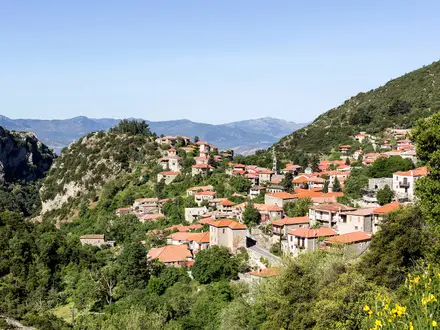
The Limestone Way is a 74 km waymarked footpath through the White Peak of the Peak District National Park in England. It runs from Castleton in Derbyshire to Rocester in Staffordshire and usually takes 3-4 days. This is a moderate point-to-point walk: expect limestone dales, rolling pasture, dry-stone walls, stiles, green lanes and some steep dale climbs, but no scrambling or mountain terrain. It suits walkers who want a village-based multi-day route with classic southern Peak District scenery.
Route Overview
The route is conventionally walked north to south, starting in Castleton in the Hope Valley and finishing at Rocester in the Dove valley. From Castleton it climbs steeply through Cave Dale beneath Peveril Castle, then crosses Bradwell Moor towards Peak Forest, Hay Dale and Peter Dale. Further south it passes Miller's Dale on the River Wye, Flagg, Monyash, Youlgreave, Harthill Moor, Elton, Winster, Bonsall, Grangemill, Parwich, Tissington, Thorpe and Lower Ellastone before Rocester. It also crosses or meets the High Peak Trail, Tissington Trail and, near Miller's Dale, the Monsal Trail. As a point-to-point walk, plan end-to-end transport rather than a loop.
History of the Limestone Way
The Limestone Way was devised by Brian Spencer of Matlock Rotary Club and developed and opened in 1986 by West Derbyshire District Council. The original route ran from Matlock; in 1992 it was extended south to Rocester to connect with the Staffordshire Way. That created the present 46-mile / 74 km route from Castleton to Rocester through the White Peak. The route is now maintained and promoted by Derbyshire Dales District Council, which publishes the official Walker's Guide.
Notable highlights
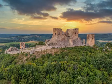
Cave Dale and Peveril Castle: The walk starts with a steep climb from Castleton up Cave Dale, a dry limestone gorge below the ruins of Norman Peveril Castle. It gives early views back over the Hope Valley.
Lathkill Dale: Near Monyash, the path clips the head of Lathkill Dale, part of the Derbyshire Dales National Nature Reserve. Hikers come here for clear water, limestone crags and spring wildflowers.
Robin Hood's Stride and Cratcliffe Rocks: On Harthill Moor, the route passes the gritstone outcrop of Robin Hood's Stride and nearby Cratcliffe Rocks. The area is linked by the ancient Portway trackway and includes a medieval hermit's cave.
Nine Ladies Stone Circle: A short step off-route on Stanton Moor, this Bronze Age stone circle is tied to the legend of nine women turned to stone for dancing on the Sabbath. The lone King Stone stands nearby.
Tissington and well dressing: Tissington is an estate village known for its hall, stone cottages and well-dressing tradition. In season, its wells are decorated with pictures made from flower petals.
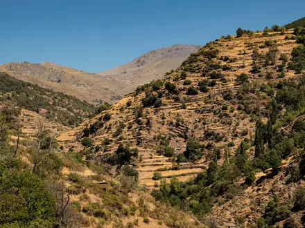
White Peak limestone dales: Hay Dale, Peter Dale and Miller's Dale show the route's classic White Peak character: pale dry-stone walls, hay meadows, river valleys and fossil-rich limestone country.
Challenges to expect
The Limestone Way is moderate rather than technical, but the cumulative ascent is 1,794 m and there are many stiles, dry-stone walls and short steep climbs and descents, including the Cave Dale start. Field paths and limestone dales can be muddy and slippery in wet weather. Waymarking is present, but carry OS Explorer OL1, OL24 and 259 or equivalent mapping. For different English walking options, compare the Amber Valley Route, Ashby Canal Trail or hillier Beacons Way.
HikeList Score
Limestone Way scored 85/100 on HikeList's trail-quality metrics.
See score breakdownHide breakdown
- Ideal length 74
- Balanced challenge 100
- Scenery & wildness 78
- Varied terrain 71
- Accommodation 100
- Food & support 81
- Path quality 98
- Season flexibility 89
Computed from length, challenge, scenery & wildness, terrain variety, accommodation, food & support, path quality and season flexibility.
Show more data Show less
- Grassland
- Hills
- Dirt
- Rocky
- Grass
- Guesthouses
- Hotels
- Hostels
- Campsites
- Family Friendly
- Dog Friendly On Leash
- Established Campsites
- Picnic Areas
- Public Transport Access Points
Photos from hikers
Taken on the trail by people who've reviewed Limestone Way.
Reviews
How would you rate Limestone Way?
Tap a star to start your review — you could be the first.