GR65 (Le Puy Camino)
How would you rate GR65 (Le Puy Camino)?
Tap a star to share your experience and help other hikers.
GR65 (Le Puy Camino): A Practical Hiking Guide
HikeList Score
GR65 (Le Puy Camino) scored 87/100 on HikeList's trail-quality metrics.
See score breakdownHide breakdown
- Ideal length 56
- Balanced challenge 100
- Scenery & wildness 88
- Varied terrain 100
- Accommodation 100
- Food & support 88
- Path quality 84
- Season flexibility 89
Computed from length, challenge, scenery & wildness, terrain variety, accommodation, food & support, path quality and season flexibility.
The GR65, or Le Puy Camino / Via Podiensis, is a 735 km waymarked pilgrimage route across southern France, from Le Puy-en-Velay to Saint-Jean-Pied-de-Port. Most walkers take 28-32 days. It is a moderate point-to-point trek: non-technical, but long enough to demand steady fitness and repeated full walking days. Expect Auvergne hills, the exposed Aubrac plateau, Lot valley towns, Quercy causses, Gascon farmland and the Basque foothills before the Pyrenees.
Route Overview
The route starts in Le Puy-en-Velay in Haute-Loire and runs west and south-west to Saint-Jean-Pied-de-Port in the Basque Country, where it links with the Camino Frances into Spain. Main places on the line include Saint-Privat-d'Allier, Saugues, Aumont-Aubrac, Nasbinals, Saint-Chely-d'Aubrac, Espalion, Estaing, Conques, Figeac, Cahors, Lauzerte, Moissac, Auvillar, Lectoure, Condom, Eauze, Aire-sur-l'Adour and Navarrenx. It is a linear GR trail, marked with red-and-white balisage and Camino scallop shells. Official variants include the GR651 down the Cele valley and the GR652 via Rocamadour. For gentler French walking, compare the Canal du Midi Towpath or Burgundy Canal Towpath; for a Pyrenean contrast, see the Cirque de Gavarnie Trails.
History of the Le Puy Camino
Le Puy-en-Velay is central to French Camino history: in 950 or 951, Godescalc, bishop of Le Puy, made one of the first recorded non-Iberian pilgrimages to Santiago de Compostela. The 12th-century Codex Calixtinus described four great French routes to Santiago, including the Via Podiensis through Conques, Cahors and Moissac. Revived in the 20th century as the GR65, the route and associated monuments were inscribed in 1998 as part of the UNESCO World Heritage “Routes of Santiago de Compostela in France”.
Notable highlights
- Le Puy-en-Velay: The traditional starting point, with the Cathedral of Notre-Dame and a dawn pilgrim blessing. The town is known for volcanic pinnacles topped by Saint-Michel d'Aiguilhe chapel and Notre-Dame de France.
- The Aubrac plateau: The wildest and most exposed section, crossing open high ground, granite outcrops, drystone walls and grazing country. It includes the trail’s highest ground, around 1368 m.
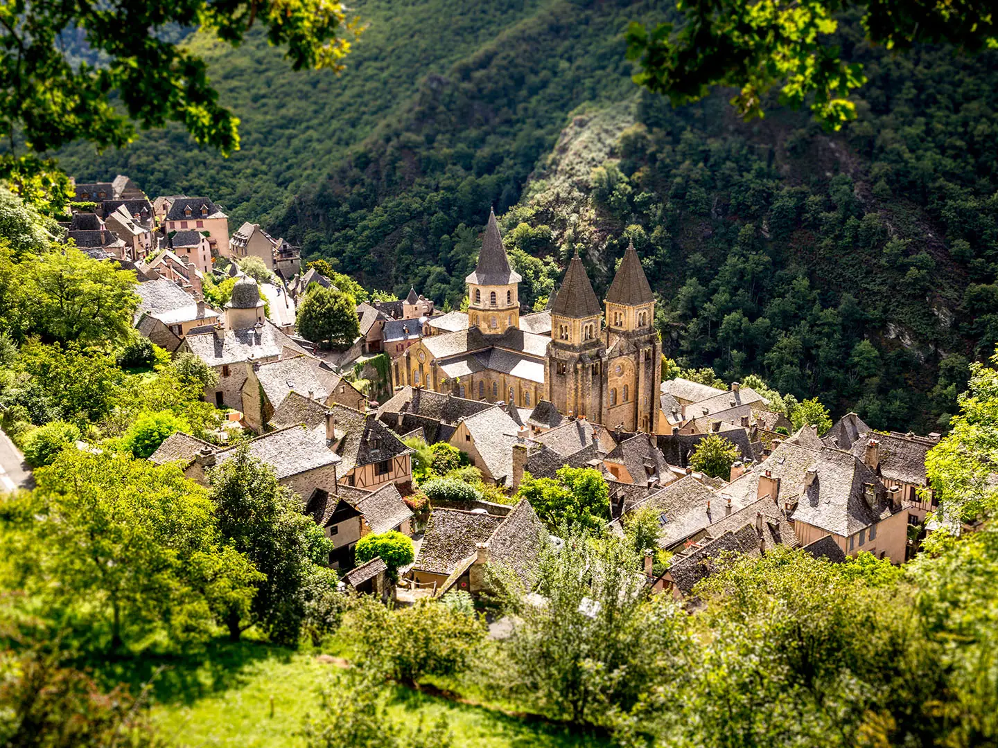
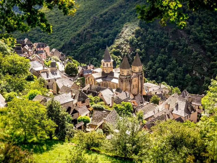
- Conques: A medieval village in a steep wooded gorge, centred on the Romanesque Abbey of Sainte-Foy. It is one of the major pilgrimage stops on the GR65.
- Cahors and the Pont Valentre: Cahors is reached by the fortified Pont Valentre, a 14th-century bridge with three towers and part of the UNESCO Camino inscription.
- Moissac: The Abbey of Saint-Pierre is noted for its Romanesque cloister and sculpted south portal. After Moissac, the route briefly follows the Garonne canal towpath.
- Gascony and the Gers: The western stages cross rolling farmland, vineyards, bastide towns and Armagnac country, including Condom and Larressingle.
Challenges to expect
The GR65 is not technical, but the scale is the challenge: nearly a month of continuous walking on mixed dirt, gravel, stony and paved surfaces. The Aubrac plateau can be cold, wet, foggy and exposed even in summer, while the Quercy causses can be hot and shadeless. Navigation is generally straightforward thanks to GR balisage, but note the GR651 and GR652 variants. Services are best relied on in the April-October walking season.
HikeList Score
GR65 (Le Puy Camino) scored 87/100 on HikeList's trail-quality metrics.
See score breakdownHide breakdown
- Ideal length 56
- Balanced challenge 100
- Scenery & wildness 88
- Varied terrain 100
- Accommodation 100
- Food & support 88
- Path quality 84
- Season flexibility 89
Computed from length, challenge, scenery & wildness, terrain variety, accommodation, food & support, path quality and season flexibility.
 France
Show more data Show less
- Plateau
- Hilly
- Forest
- River Valley
- Dirt
- Gravel
- Rocky
- Paved
- Hotels
- Hostels
- Lodges
- Campsites
- Family Friendly
- Pet Friendly
- Restrooms
- Water Sources
- Campsites
- Shelters
- Picnic Areas
Download Our Full Guide to GR65 (Le Puy Camino) FREE!
Get our comprehensive guide to this hike for free. Save it for later reading or print out at home.
Articles related to this hike
In these collections
Photos from hikers
Taken on the trail by people who've reviewed GR65 (Le Puy Camino).
GR65 (Le Puy Camino): The Complete Guide
 i
Image by kevin_guillois
i
Image by kevin_guillois The GR65 from Le Puy-en-Velay to Saint-Jean-Pied-de-Port is France’s great month-long Camino: 735 km of waymarked walking from the volcanic hills of the Massif Central to the Basque foothills. It suits reasonably fit walkers who want a long, social, well-serviced pilgrimage route without technical mountain terrain.
The route changes character often. It leaves Le Puy past scallop shells and red-and-white GR balisage, crosses the Margeride and the exposed Aubrac plateau, then drops into the Lot valley through places such as Saint-Côme-d’Olt, Espalion, Estaing and Conques.
Further west, the walking becomes drier and warmer across the Quercy causses towards Cahors, then softer through Gascony, the Gers and Béarn. The finish at Saint-Jean-Pied-de-Port feels like a real threshold, with the Camino continuing over the Pyrenees into Spain.
This is a moderate route, but not a casual one. The challenge is the accumulation of full walking days, the need to book beds in busy periods, and the contrast between cold, wet exposure on the Aubrac and hot, shadeless stretches on the causses.
This guide covers stages, days, accommodation, food, transport, terrain and the common mistakes to avoid.
Stage-by-Stage Guide
Distances are approximate and services change seasonally. On every stage, gîte, hostel, shop, café, baggage-transfer and local transport details should be checked before travelling, especially outside April-October and during the May-September peak.
Stage 1: Le Puy-en-Velay to Saint-Privat-d'Allier — 23 km
This opening stage leaves the upper town of Le Puy-en-Velay from the Cathédrale Notre-Dame du Puy, where the GR balisage and scallop-shell markers lead out onto the Voie du Puy. The walking moves quickly from the built-up start into the volcanic Velay hills on a mix of lanes, tracks and paths.
Le Puy is the best place to stock up before departure, with accommodation and transport connections including the railway station reached via Saint-Étienne. Saint-Privat-d'Allier has pilgrim accommodation and local road access, but onward public transport should be checked before relying on it.
Navigation is straightforward if the red-and-white GR marks are followed carefully out of town; early urban exits are where missed turns most often happen. Expect some paved sections and do not underestimate the first day simply because the route is well waymarked.
Stage 2: Saint-Privat-d'Allier to Saugues — 19 km
This is one of the first genuinely testing days, with the route dropping into the wooded Allier gorge at Monistrol-d'Allier and then climbing back out towards Saugues. The stage is shorter than many later days, but the descent and re-ascent make it feel more demanding than the distance suggests.
Monistrol-d'Allier is the key intermediate place on the stage; check opening times before depending on food or drink there. Saugues is an established pilgrim stop with gîtes, chambres d'hôtes and other accommodation options.
Take care on stony or steep ground in the gorge, particularly after rain. The waymarks are generally reliable, but keep an eye on junctions around Monistrol-d'Allier where walkers may be distracted by the change from descent to climb.
Stage 3: Saugues to Le Sauvage — 18 km
The route now enters the Margeride, a quieter highland section of rolling forest, moorland and open country. Underfoot is typically a mixture of dirt track, gravel, stony path and minor lane.
Le Sauvage is a remote and memorable stop associated with the former pilgrim commandery. Because it is not a large service town, accommodation and evening meals should be booked ahead rather than left to chance.
Carry enough food and water from Saugues for the day unless intermediate services have been checked in advance. Navigation is not difficult in clear weather, but open highland sections can feel exposed in poor visibility, so keep the GR balisage in sight.
Stage 4: Le Sauvage to Aumont-Aubrac — 28 km
This is a longer day across the Margeride highlands, with sustained rural walking before reaching Aumont-Aubrac. The terrain remains non-technical, but the length makes steady pacing important.
Aumont-Aubrac is a useful trail town with pilgrim accommodation and services, and it is a natural point to regroup before the Aubrac plateau. Between Le Sauvage and Aumont-Aubrac, food and drink availability should not be assumed without checking current opening times.
The walking is exposed in places and can be cold or wet in poor weather, even outside winter. Plan this stage with a proper waterproof layer accessible rather than buried in the pack.
Stage 5: Aumont-Aubrac to Nasbinals — 27 km
This stage reaches the open Aubrac plateau, one of the defining landscapes of the GR65. Expect high grazing country, granite outcrops, drystone walls and old drovers' roads, with the route crossing its highest ground at around 1,368 m between Aumont-Aubrac and Nasbinals.
Nasbinals is the overnight stop, with pilgrim accommodation available in season. Carry food and water from Aumont-Aubrac unless current intermediate services have been checked.
The Aubrac is the most exposed part of the route: fog, wind, rain and cold are realistic concerns even in summer. Livestock are part of this grazing landscape, so give cattle space, close gates where present and avoid taking shortcuts across pasture.
Stage 6: Nasbinals to Saint-Chély-d'Aubrac — 17 km
A shorter stage, but an important one, crossing the last of the high Aubrac country via the tiny stone village of Aubrac before descending towards Saint-Chély-d'Aubrac. The terrain mixes open plateau tracks with rougher stony sections and descent.
Aubrac is the main place passed on the stage and is a natural break point, though services should still be checked before depending on them. Saint-Chély-d'Aubrac has pilgrim accommodation at the end of the day.
Do not treat the lower distance as a rest day in bad weather: the first part of the stage remains high and exposed. In mist, follow the GR markings carefully and avoid drifting onto farm tracks or minor paths.
Stage 7: Saint-Chély-d'Aubrac to Saint-Côme-d'Olt — 22 km
This stage completes the move from the Aubrac towards the Lot valley. The walking becomes greener and more settled, with a mixture of tracks, lanes and paths leading towards Saint-Côme-d'Olt.
Saint-Côme-d'Olt is one of the notable villages of the route, known for its distinctive twisted church spire. Accommodation is available in and around the village, but it remains sensible to book ahead during the busier Le Puy to Conques section.
The change in terrain can mean more hard surfaces and village approaches after the open plateau. Navigation is generally clear, but watch for waymarks through settlements where streets and local paths intersect.
Stage 8: Saint-Côme-d'Olt to Espalion — 9 km
This is a short Lot valley stage and one of the easiest opportunities to reduce fatigue after the Aubrac. It is suitable as a lighter walking day, a late start, or a practical half-day for laundry, rest and resupply.
Both Saint-Côme-d'Olt and Espalion are established route settlements with pilgrim services, though accommodation should still be reserved in the peak season. Food and drink options are more dependable here than on the remote highland stages, but opening days and hours still vary.
Expect more valley walking, lanes and surfaced sections than on the plateau. Because the stage is short, it is tempting to push on, but the following days to Conques and beyond are worth planning around available beds rather than distance alone.
Stage 9: Espalion to Estaing — 12 km
Another short stage follows the Lot valley westwards to Estaing. The day is not technically difficult and gives time to enjoy Estaing, with its château forming one of the notable sights of this part of the route.
Espalion and Estaing both have pilgrim accommodation and services in season. If walking without reservations, this popular stretch still deserves a phone call ahead, particularly from May to September.
The terrain is a mix of lanes, tracks and valley paths, with some hard surfaces. Keep following the GR65 waymarks through built-up areas, where local walking routes and village streets can make the way less obvious than it is in open country.
Stage 10: Estaing to Golinhac — 16 km
The route leaves the immediate ease of the Lot valley and moves towards quieter hill and woodland country on the approach to the Conques section. The distance is moderate, but the day should be treated as a proper walking stage rather than a short valley stroll.
Golinhac is a smaller overnight stop, so accommodation and evening meals should be arranged in advance. Carry enough food and water from Estaing unless current services on the route have been checked.
Underfoot, expect the usual GR65 mix of paths, tracks, stony ground and minor roads. Wet weather can make wooded or shaded sections slippery, and navigation deserves attention at rural junctions.
Stage 11: Golinhac to Conques — 21 km
This stage leads into the steep wooded setting of Conques, one of the great pilgrimage stops on the Voie du Puy. The arrival is a major highlight, with the medieval village clustered around the Romanesque Abbey-church of Sainte-Foy and its carved Last Judgement tympanum.
Conques is popular and accommodation demand can be high, especially on the busy Le Puy to Conques section. Book ahead rather than assuming a bed will be available on arrival.
The approach includes wooded and hilly terrain, with possible slippery sections after rain. The final descent and village approach require more care than the distance alone suggests, particularly late in the day or with a heavy pack.
Stage 12: Conques to Decazeville — 20 km
Leaving Conques means leaving one of the route's most atmospheric stops and returning to a more workmanlike day of tracks, lanes and rural paths. The stage is moderate in distance, but the terrain remains undulating enough to keep the day physical.
Decazeville is the end point and has accommodation options for walkers. Food and water should be carried from Conques unless current intermediate services have been checked.
Navigation is generally by GR red-and-white balisage and scallop markers, but take care on the departure from Conques where steep wooded ground and local paths can complicate the start. Road sections and village approaches require normal traffic awareness.
Stage 13: Decazeville to Figeac — 28 km
This is a longer stage ending in Figeac, a well-preserved medieval town of stone houses and squares and the birthplace of Jean-François Champollion. The day is more about covering distance than dramatic terrain, with mixed paths, tracks, lanes and paved sections.
Figeac is a major trail stop with accommodation and services, making it a useful place for resupply and recovery. Because the stage is 28 km, start with enough food and water rather than relying on unplanned stops.
The main warning is cumulative fatigue after the Conques section. Keep navigation disciplined late in the day, as tired walkers are more likely to miss GR marks on road crossings and town approaches.
Stage 14: Figeac to Cajarc — 31 km
This is one of the longer days and begins the transition towards the limestone country of the Quercy causses. Expect a mixture of tracks, stony paths, lanes and harder surfaces, with fewer easy rest opportunities than in the larger valley towns.
Cajarc is the end point and has pilgrim accommodation in season. Food and water availability between Figeac and Cajarc should be checked before travelling; otherwise carry enough for a full day.
The length is the key issue. In warm weather, start early and manage water carefully, as the Quercy sections can be hot and relatively shadeless.
Stage 15: Cajarc to Limogne-en-Quercy — 18 km
This shorter stage crosses classic Quercy causse country: dry limestone plateau, drystone walls, juniper and stone shepherds' huts known as cazelles or gariottes. Underfoot can be stony and hard, even when the gradients are not severe.
Limogne-en-Quercy is the overnight stop, with pilgrim accommodation available in season. Carry water from Cajarc and do not assume reliable refills away from settlements without checking current services.
Heat is the main concern on this stage in summer, along with foot fatigue from stony ground. Good sun protection and an early start are more useful here than heavy mountain equipment.
Stage 16: Limogne-en-Quercy to Cahors — 30 km
A long Quercy stage leads to Cahors and the Pont Valentré, the fortified 14th-century bridge over the Lot and one of the great monuments of the route. The walking remains a mix of limestone paths, tracks, lanes and paved approaches into the city.
Cahors is a major service point with a wide range of accommodation compared with smaller stage villages. Stock up in Limogne-en-Quercy before leaving and carry enough water for a hot, exposed day unless intermediate stops have been checked.
This stage can feel demanding in high temperatures because of the dry causse terrain and the 30 km distance. Pay close attention on the approach into Cahors, where urban navigation and road crossings replace the simpler rural waymarking.
Stage 17: Cahors to Lascabanes — 23 km
The route leaves Cahors and continues through the Quercy landscape towards Lascabanes. After the city start, the day returns to rural paths, lanes and tracks, with the usual mix of stony and paved surfaces.
Lascabanes is a smaller pilgrim stop, so accommodation and meals should be arranged ahead. Cahors is the best place to resupply before this stage.
Navigation out of Cahors needs attention, especially around streets, bridge approaches and road junctions. In hot weather, treat this as another exposed Quercy day and carry more water than would be needed on the greener Lot valley stages.
Stage 18: Lascabanes to Lauzerte — 23 km
This stage moves west through rolling rural country towards Lauzerte. The walking is moderate in distance and generally non-technical, with a practical mix of tracks, minor roads, paths and occasional stony ground.
Lauzerte has pilgrim accommodation and services in season. Between Lascabanes and Lauzerte, food and drink availability should be checked in advance rather than assumed.
The main planning issue is accommodation spacing: do not arrive in smaller stage towns late in the day without a bed arranged during peak months. Navigation remains by GR balisage, but take care at rural junctions where farm tracks and lanes meet.
Stage 19: Lauzerte to Moissac — 24 km
The route continues to Moissac, a major cultural and pilgrim stop known for the Abbey of Saint-Pierre, its Romanesque cloister and sculpted south portal. The day is a moderate-length transition from rural walking into a busy stage town.
Moissac has a strong accommodation and service base, but it is also one of the places where booking ahead is advisable in the busy season. Carry daytime food and water from Lauzerte unless intermediate services have been checked.
Expect a mixture of paths, lanes and road approaches. The final kilometres into larger towns often require more attention than open-country sections because waymarks compete with traffic, signs and street layouts.
Stage 20: Moissac to Auvillar — 21 km
Beyond Moissac the GR65 briefly follows the Canal de Garonne towpath, giving this stage a different character from the hill and causse walking earlier on the route. The terrain is generally straightforward, with towpath, lanes, tracks and surfaced sections.
Auvillar is the end point and has pilgrim accommodation in season. Moissac is the best place to stock up before leaving; check any intermediate services before relying on them.
Towpath and paved walking can be easy to follow but hard on feet over distance, so do not ignore footwear and blister management. Navigation is simple where the route follows the canal, but still requires care when leaving it and entering settlements.
Stage 21: Auvillar to Lectoure — 33 km
This is one of the longest stages and enters the rolling farmland, vineyards and bastide-town country associated with Gascony and the Gers. The walking is not technical, but the distance and potential exposure make it a serious day.
Lectoure is a cathedral town and a significant overnight stop with pilgrim accommodation and services. Carry a full day's food and water unless current intermediate options have been checked.
Heat and sun can be more wearing here than gradients, particularly across open agricultural country. Start early in summer and keep a margin of energy for navigation into Lectoure at the end of a long day.
Stage 22: Lectoure to Condom — 20 km
This stage continues through rolling Armagnac country towards Condom, another cathedral town on the route. It is a more moderate day after the long walk to Lectoure, with mixed tracks, paths and minor roads.
Both Lectoure and Condom have pilgrim services, making this a practical section for laundry, resupply or easing the pace. Accommodation in Condom should still be booked ahead in the main season.
The terrain is generally straightforward, but road walking and lane crossings require normal care. In wet weather, agricultural tracks can become muddy, particularly on the western half of the route where conditions are generally wetter than the causses.
Stage 23: Condom to Montréal-du-Gers — 17 km
A shorter Gascony stage leads from Condom towards Montréal-du-Gers, passing the fortified village of Larressingle, one of the route's most distinctive historic stops. The walking is a manageable mix of rural tracks, paths and lanes.
Montréal-du-Gers has pilgrim accommodation in season, and the shorter distance makes this a useful recovery day. Check food and drink options in Larressingle and along the stage before relying on them.
Navigation is usually uncomplicated, but make sure to return to the GR65 if taking time in Larressingle or other village streets. In hot weather, open farmland can still feel exposed despite the modest distance.
Stage 24: Montréal-du-Gers to Éauze — 17 km
This is another shorter stage through the rolling Gers and Armagnac country. Expect rural lanes, tracks, farmland and vineyard landscapes rather than difficult mountain terrain.
Éauze is the overnight stop and has pilgrim accommodation and services in season. Because the stage is not long, it can be tempting to start late, but check opening hours for shops and gîtes before assuming late arrival will be straightforward.
The main concerns are heat, hard surfaces and muddy tracks after rain. Follow the GR marks carefully through agricultural junctions where several tracks may leave the same lane.
Stage 25: Éauze to Nogaro — 20 km
The route continues west across Gascony towards Nogaro. The walking remains moderate and non-technical, with the typical GR65 combination of tracks, lanes, paths and some paved sections.
Nogaro is the stage end, with accommodation for walkers in season. Carry food and water from Éauze unless current services along the route have been checked.
This is a good stage for managing accumulated fatigue: the ground is not severe, but repeated days on hard lanes and tracks can affect feet and knees. Maintain attention at road sections and do not assume every local waymark is part of the GR65.
Stage 26: Nogaro to Aire-sur-l'Adour — 27 km
A longer day leads to Aire-sur-l'Adour, continuing through rolling farmland before the route moves towards Béarn and the Basque foothills. The terrain is varied but not technical, with tracks, lanes and road sections.
Aire-sur-l'Adour is a useful service town and overnight stop. Food and water should be carried from Nogaro unless intermediate services have been checked before departure.
The 27 km distance makes pacing important, especially in warm weather or after rain on muddy tracks. Road walking and road crossings require care, particularly near larger settlements.
Stage 27: Aire-sur-l'Adour to Arzacq-Arraziguet — 34 km
This is one of the longest stages on the itinerary and should be treated as a full, early-start walking day. The route continues west into wetter, greener country as it approaches Béarn, with rolling rural terrain underfoot.
Arzacq-Arraziguet is the end point, with pilgrim accommodation in season. Do not depend on finding food and drink en route without checking current services; carry enough from Aire-sur-l'Adour for a long day.
The main warning is simple: 34 km is a long distance with a pack, even on non-technical ground. In wet conditions, mud can slow progress, so avoid planning tight onward transport or a late unbooked arrival.
Stage 28: Arzacq-Arraziguet to Navarrenx — 29 km
This stage continues through Béarn, passing Arthez-de-Béarn on the way to Navarrenx. The walking is sustained rather than difficult, with lanes, tracks, rural paths and potentially wetter ground than on the Quercy or Gers sections.
Navarrenx is the overnight stop and has pilgrim accommodation in season. Arthez-de-Béarn is the key named place on the stage, but food, water and opening times should be checked before relying on it.
Expect changeable weather as the route nears the Basque foothills. Navigation remains waymarked, but road junctions and village exits deserve attention, especially when tired near the end of a 29 km stage.
Stage 29: Navarrenx to Saint-Jean-Pied-de-Port — 34 km
The final walking stage is long and moves through Aroue and Ostabat-Asme before reaching Saint-Jean-Pied-de-Port, the fortified Basque town at the foot of the Pyrenees. The landscape becomes wetter and more folded as the route approaches the Basque foothills.
Saint-Jean-Pied-de-Port has pilgrim services and onward transport on the SNCF TER branch line to Bayonne, with connections beyond; train and bus times should be checked before travelling. Accommodation at the finish is usually plentiful in season, but it is still wise to book ahead because many walkers continue onto the Camino Francés.
Carry sufficient food and water from Navarrenx unless current services in Aroue, Ostabat-Asme or elsewhere on the stage have been checked. The GR65 ends at Saint-Jean-Pied-de-Port; any onward walk over the Roncesvalles/Roncevaux pass into Spain is a separate mountain stage and should be planned separately.
Recommended Itinerary
Standard itinerary: 29 walking days
This is a practical month-long schedule using the stage distances in the route brief. It keeps the classic Le Puy-en-Velay to Saint-Jean-Pied-de-Port line intact, with shorter recovery days through parts of the Lot valley and several longer days across Quercy, Gascony, Béarn and the Basque foothills.
Book ahead in the May–September peak, especially from Le Puy-en-Velay to Conques and around Cahors and Moissac. Many gîtes and pilgrim hostels are seasonal, with closures common outside the April–October walking season; this should be checked before travelling.
| Day | From | To | Approx. distance | Why this stage makes sense | Services/accommodation notes |
|---|---|---|---|---|---|
| 1 | Le Puy-en-Velay | Saint-Privat-d'Allier | 23 km | A full but sensible first day out of Le Puy-en-Velay, allowing the route to leave the volcanic Velay hills without over-stretching the start. | Saint-Privat-d'Allier is a standard first-night stop. Book ahead if starting with the main pilgrim flow from Le Puy. |
| 2 | Saint-Privat-d'Allier | Saugues | 19 km | A shorter day, but not an easy one: the Allier gorge and Monistrol-d'Allier make this one of the first real tests of the route. | Saugues is an established stage town on the GR65 accommodation chain. Reserve in busy periods. |
| 3 | Saugues | Le Sauvage | 18 km | A controlled day into the Margeride highlands, useful before the longer crossing to Aumont-Aubrac. | Le Sauvage is a remote former pilgrim commandery with lodging. Availability is limited compared with larger towns, so book early. |
| 4 | Le Sauvage | Aumont-Aubrac | 28 km | A longer upland day across forest and moorland, finishing in a useful stop before the Aubrac plateau. | Aumont-Aubrac is a key staging point before the exposed Aubrac section. Confirm accommodation and evening meal arrangements. |
| 5 | Aumont-Aubrac | Nasbinals | 27 km | A demanding but logical Aubrac day, crossing open high country and reaching the route’s highest ground at around 1,368 m. | Nasbinals is the natural overnight stop after the plateau crossing. Weather can be cold, wet and exposed even in summer. |
| 6 | Nasbinals | Saint-Chély-d'Aubrac | 17 km | A shorter day after the high plateau, passing through the tiny stone village of Aubrac before dropping towards Saint-Chély-d'Aubrac. | A good recovery stage after the Aubrac. Book ahead as bed numbers in smaller villages can be tight. |
| 7 | Saint-Chély-d'Aubrac | Saint-Côme-d'Olt | 22 km | A steady transition from Aubrac towards the Lot valley, ending in one of the route’s notable villages. | Saint-Côme-d'Olt is a recognised overnight halt. Reserve in advance during peak Camino weeks. |
| 8 | Saint-Côme-d'Olt | Espalion | 9 km | A deliberately short day, useful for recovery, laundry, food shopping and giving tired legs a break after the upland opening week. | Espalion is a convenient Lot valley stop. Faster walkers commonly combine this with an adjacent short stage. |
| 9 | Espalion | Estaing | 12 km | Another short Lot valley stage, keeping the itinerary gentle before the climb towards Golinhac and Conques. | Estaing is a popular pilgrim stop with high demand in season. Book ahead. |
| 10 | Estaing | Golinhac | 16 km | A moderate stage that positions you well for the following day’s approach to Conques. | Golinhac is a smaller stage stop; confirm opening dates and meal availability before relying on a bed. |
| 11 | Golinhac | Conques | 21 km | A classic arrival day into Conques, long enough to feel substantial but short enough to leave time for the abbey village. | Conques is one of the busiest and most atmospheric stops on the GR65. Accommodation should be booked well ahead in peak months. |
| 12 | Conques | Decazeville | 20 km | A manageable restart after Conques, leaving the wooded gorge and continuing towards the Lot and Célé country. | Decazeville is a practical overnight stop after leaving Conques. Check current gîte and hotel availability. |
| 13 | Decazeville | Figeac | 28 km | A longer stage into Figeac, but it keeps momentum and reaches a major medieval town with good onward staging. | Figeac is a useful larger halt for rest, supplies and accommodation. Book ahead if planning a rest night. |
| 14 | Figeac | Cajarc | 31 km | One of the longer days, moving decisively into the Quercy section and setting up a shorter following day. | Cajarc is the logical stop before the causse stages towards Limogne-en-Quercy and Cahors. Start early in hot weather. |
| 15 | Cajarc | Limogne-en-Quercy | 18 km | A shorter day across Quercy terrain, useful after the 31 km stage from Figeac. | Limogne-en-Quercy is a standard stage settlement. The causses can be hot and exposed, so plan food and water carefully. |
| 16 | Limogne-en-Quercy | Cahors | 30 km | A long day to reach Cahors and the Pont Valentré, with enough distance to clear the dry limestone plateau in one push. | Cahors is a major stop and a sensible place for a rest night. Accommodation demand is high in season. |
| 17 | Cahors | Lascabanes | 23 km | A steady post-Cahors stage that restarts the route without immediately forcing another 30 km day. | Lascabanes is a smaller pilgrim stop; confirm current accommodation opening before booking the day around it. |
| 18 | Lascabanes | Lauzerte | 23 km | A balanced day through the transition towards Tarn-et-Garonne, ending in a notable hilltop stop. | Lauzerte is a popular overnight halt. Reserve ahead in the main walking season. |
| 19 | Lauzerte | Moissac | 24 km | A practical distance into Moissac, allowing time for the Abbey of Saint-Pierre and its cloister. | Moissac is a major Camino stop, so book ahead. It is also a sensible rest-day candidate. |
| 20 | Moissac | Auvillar | 21 km | A moderate day after Moissac, including the easier rhythm of the route beyond town and the brief Canal de Garonne towpath section. | Auvillar is a regular overnight stop. Check accommodation opening if walking outside the core season. |
| 21 | Auvillar | Lectoure | 33 km | A long Gascony day, best suited to walkers who are now trail-fit after nearly three weeks on the GR65. | Lectoure is an important stage town. Because this is a long day, secure a bed before setting out. |
| 22 | Lectoure | Condom | 20 km | A shorter recovery stage after the 33 km to Lectoure, finishing in a cathedral town on the Gers section. | Condom has a range of pilgrim-oriented accommodation. Book ahead in summer. |
| 23 | Condom | Montréal-du-Gers | 17 km | A short but worthwhile day through Armagnac country, with Larressingle on the route before Montréal-du-Gers. | Montréal-du-Gers works well as a lighter overnight stop. Faster walkers may combine this with the next stage. |
| 24 | Montréal-du-Gers | Éauze | 17 km | Another short Gascony stage, useful for recovery and for keeping the itinerary comfortable before the final western push. | Éauze is a standard halt before Nogaro. Reserve ahead if walking during peak holiday weeks. |
| 25 | Éauze | Nogaro | 20 km | A moderate day that keeps progress steady without overloading the legs before two longer stages. | Nogaro is a practical overnight stop. Confirm gîte or chambre d'hôte availability before relying on same-day booking. |
| 26 | Nogaro | Aire-sur-l'Adour | 27 km | A longer but manageable stage into Aire-sur-l'Adour, maintaining momentum across the western farmland. | Aire-sur-l'Adour is a useful service and accommodation stop before the 34 km stage to Arzacq-Arraziguet. |
| 27 | Aire-sur-l'Adour | Arzacq-Arraziguet | 34 km | One of the longest days on this itinerary. Start early, especially in hot weather, and avoid assuming easy late accommodation. | Book Arzacq-Arraziguet in advance. Slower walkers should consider splitting this day where accommodation allows; check official mapping before booking. |
| 28 | Arzacq-Arraziguet | Navarrenx | 29 km | A substantial day into Béarn, long but shorter than the previous stage and a sensible final staging point before Saint-Jean-Pied-de-Port. | Navarrenx is a key stop before the Basque approach. Reserve ahead, particularly if arriving with a wave of pilgrims. |
| 29 | Navarrenx | Saint-Jean-Pied-de-Port | 34 km | A long final stage to the fortified Basque town that marks the end of the GR65 and the gateway to the Camino Francés. | This is a long finish as listed. Aroue and Ostabat-Asme are on-route intermediate places if the final approach needs splitting; check official mapping before booking. |
Slower variant: 31–34 walking days plus rest days
This suits walkers carrying a full pack, anyone new to month-long walking, and those who want more time in Conques, Figeac, Cahors, Moissac or Saint-Jean-Pied-de-Port. The easiest way to slow the route is not to shorten every day, but to add rest days and split the longest stages.
Good places to consider adding time are Conques, Figeac, Cahors and Moissac, all of which are major stops on the route. The longest listed days — Figeac to Cajarc, Limogne-en-Quercy to Cahors, Auvillar to Lectoure, Aire-sur-l'Adour to Arzacq-Arraziguet and Navarrenx to Saint-Jean-Pied-de-Port — are the first candidates for splitting where accommodation is available. Exact intermediate distances should be checked on official mapping before booking.
Faster variant: 26–28 walking days
This suits fit walkers who are comfortable with repeated 25–35 km days and who are not relying on long sightseeing stops. It is most realistic once the body has adapted after the first week, rather than by forcing bigger days immediately out of Le Puy-en-Velay.
The most obvious compression is in the shorter Lot and Gascony stages. For example, Saint-Côme-d'Olt to Estaing is roughly 21 km if the Espalion night is skipped, and Condom to Éauze is roughly 34 km if Montréal-du-Gers is skipped. Any faster plan should still protect the exposed Aubrac crossing and the hot Quercy causses; long stages there are more serious than the map distance alone suggests.
Practical booking approach
For the standard itinerary, reserve at least the first week from Le Puy-en-Velay through the Aubrac and towards Conques during peak season. After that, many walkers book a few days ahead, but Cahors, Moissac and the busier western stages still reward early reservations.
If walking outside April–October, do not assume gîtes, pilgrim hostels or demi-pension meals will be operating. Opening dates, prices and meal arrangements should be checked before travelling.
Planning the Route
How many days to allow
Most walkers should plan on about 4–6 weeks for the full Le Puy-en-Velay to Saint-Jean-Pied-de-Port route. A strong walker can follow a 28-stage schedule, but many independent hikers are better served by 28–32 walking days plus any rest days.
The route is not technically difficult, but it is long enough that rushing it often creates problems: sore feet, missed accommodation windows, and too little margin for bad weather on the Aubrac or heat on the Quercy causses. A slightly slower plan is usually more reliable than trying to bank repeated 30 km-plus days.
A practical full-route plan is to build around the established stage towns, then add slack where the itinerary becomes exposed, hot or culturally worth lingering over. Conques, Figeac, Cahors, Moissac and Saint-Jean-Pied-de-Port are all natural places to pause if time allows.
Are the stages flexible?
Daily stages are strongly shaped by the chain of gîtes d'étape, chambres d'hôtes, pilgrim hostels, hotels and campsites along the GR65. This makes the route much easier to organise than a remote mountain trek, but it also means accommodation can dictate the day’s distance.
The standard stages vary widely. Some days are short, such as Saint-Côme-d'Olt to Espalion and Espalion to Estaing, while other sections include long days of around 30 km or more, notably Figeac to Cajarc, Limogne-en-Quercy to Cahors, Auvillar to Lectoure, Aire-sur-l'Adour to Arzacq-Arraziguet and Navarrenx to Saint-Jean-Pied-de-Port.
Those longer days can often be made more manageable by booking intermediate accommodation, but this should not be assumed at short notice. In the May–September peak, and especially on the busy Le Puy to Conques section and around Cahors and Moissac, book ahead rather than relying on turning up.
Fast, standard or slower itineraries
| Approach | Best for | Planning notes |
|---|---|---|
| Fast itinerary | Fit walkers used to repeated long days | Works best if accommodation is booked in advance and pack weight is kept low. Little margin for heat, rain, injury or closed services. |
| Standard itinerary | Most experienced long-distance walkers | Follow the main stage-town rhythm, with a few long days balanced by shorter ones. Allow 28–32 walking days. |
| Slower itinerary | First-time month-long hikers, pilgrims prioritising comfort, or anyone walking in hotter weather | Split the longest stages where possible and add rest days. This is the safest way to protect feet and avoid cumulative fatigue. |
The GR65 is better suited to a steady rhythm than to aggressive mileage. The terrain changes repeatedly — Velay hills, Margeride, Aubrac, Lot valley, Quercy causses, Gascony, Béarn and Basque foothills — so daily effort is affected by more than distance alone.
Section hiking the GR65
Section hiking is practical. The route passes through a long chain of recognised stage towns, and both ends have rail access: Le Puy-en-Velay by train via Saint-Étienne, and Saint-Jean-Pied-de-Port on the TER branch from Bayonne.
There is no direct rail link between the two endpoints, so anyone walking a section rather than the full route should plan transport town by town. SNCF train and bus times, including any TER bus replacement, should be checked before travelling.
Common section breaks are naturally created by the route’s major towns and pilgrimage stops, including Conques, Figeac, Cahors and Moissac. Exact access options vary, so transport should be checked for the chosen start and finish before accommodation is booked.
Shortening, extending and variants
The simplest way to shorten the walk is to complete a named section rather than the whole route: for example, Le Puy-en-Velay to Conques, a central section through Figeac and Cahors, or a western section through the Gers and into Saint-Jean-Pied-de-Port. Avoid planning a shortened walk around an arbitrary map point unless transport and accommodation are already clear.
The route can also be extended naturally from Saint-Jean-Pied-de-Port by continuing over the Roncesvalles/Roncevaux pass into Spain on the Camino Francés. That is a separate onward route and should be planned with its own accommodation, weather and stage information.
Two official waymarked variants exist: the GR651 down the Célé valley and the GR652 via Rocamadour. If using either variant, recalculate distance, stages, accommodation and transport rather than assuming the standard GR65 schedule still applies.
What to book first
Accommodation is the main planning constraint. The GR65 has a dense network of pilgrim-friendly places to stay, but demand is high in the main April–October walking season and especially from May to September.
Many gîtes and hostels close outside the main season, particularly from November to March. Opening dates, meal availability and current booking conditions should be checked before travelling.
The créanciale is also worth arranging before departure. It is commonly needed for pilgrim hostel access and is the document used for collecting stamps towards the Compostela.
Food and water planning
Many walkers use gîtes offering demi-pension half-board, which reduces the amount of food that needs to be carried. Still, do not assume that every small village has a shop, café or evening meal available.
Carry enough food for the day unless the next resupply is certain. This matters most on the more exposed or sparsely settled-feeling sections, including the Aubrac plateau and the dry Quercy causses.
Water planning should be conservative in hot weather. The causses can be very hot and shadeless, so start with enough water for the full stage unless reliable refill points have been checked locally.
Navigation and route information
The GR65 is well waymarked with red-and-white GR balisage and Camino scallop-shell markers, so navigation is usually straightforward. Even so, carry proper route information rather than relying only on signs.
The standard French topo-guide is the FFRandonnée GR65 guide, and the Miam-Miam-Dodo accommodation guide is widely used on this route. These are particularly useful for matching stage distances to places to sleep and eat.
Seasonal diversions and local route changes can affect a day’s plan. These should be checked before travelling, especially if walking outside the busiest part of the season.
Weather and timing considerations
The key weather planning is not snow or technical terrain, but exposure and heat. The Aubrac plateau can be cold, wet, foggy and windy even in summer, so carry layers and waterproofs rather than treating the route as a lowland Camino.
Later in the walk, the limestone causses of Quercy can be hot and shadeless. In warm weather, plan early starts, carry extra water and avoid making the longest stages harder than necessary.
April to October is the most dependable season for services. Outside that window, the walking may still be possible, but accommodation and food planning become much less forgiving and should be checked carefully before committing.
Towns, Villages and Overnight Stops
The GR65 has one of the best accommodation networks of any long-distance route in France, with gîtes d'étape, chambres d'hôtes, pilgrim accueils, hotels, B&Bs and campsites in many stage towns. The practical issue is not usually finding a type of lodging somewhere on the route, but matching availability to your stage plan: book ahead in the May-September peak, especially from Le Puy-en-Velay to Conques and around Cahors and Moissac.
Many smaller stops rely heavily on gîte meals, often as demi-pension. Do not assume that every village has a shop, restaurant or late-opening café; if a place is small or remote, arrange dinner and breakfast with the accommodation and carry food from the previous larger town.
Transport links are strongest at the two ends of the route. Le Puy-en-Velay is reached by train via Saint-Étienne, with onward connections from Lyon, while Saint-Jean-Pied-de-Port is on the SNCF TER branch from Bayonne. For intermediate towns and villages, local train, bus and taxi options vary and should be checked before travelling.
Le Puy-en-Velay
Le Puy-en-Velay is the traditional starting point of the GR65 and the best place to organise the first night, buy any missing kit and settle accommodation bookings for the opening stages. Pilgrims gather at the Cathédrale Notre-Dame du Puy, where a pilgrim mass and blessing are held each morning at 7am from 1 April to 31 October, and the red-and-white GR balisage and scallop-shell waymarks lead out from the upper town.
Accommodation choice is broader here than in the early villages, but it is still worth booking before arrival in the main walking season. Le Puy-en-Velay has a railway station reached via Saint-Étienne, with connections from Lyon; Lyon is also the nearest major airport.
Saint-Privat-d'Allier
Saint-Privat-d'Allier is the first standard overnight stop, about 23 km from Le Puy-en-Velay. It works well as a controlled first day before the route drops towards the Allier gorge.
Treat it as a small-stage stop rather than a resupply hub. Book a bed and evening meal in advance in busy periods, and do not arrive relying on late food or extensive shops.
Monistrol-d'Allier
Monistrol-d'Allier sits in the Allier gorge between Saint-Privat-d'Allier and Saugues. It is useful for walkers who want to break up the early descent and climb, or who prefer not to take the standard Saint-Privat-d'Allier to Saugues stage in one push.
It is not one of the main HikeList overnight stage ends, so accommodation and food should be checked before travelling. The surrounding gorge terrain makes it a practical place to pause, refill where available, and assess conditions before the climb out towards Saugues.
Saugues
Saugues is the second main stage town and a sensible overnight stop after the Allier gorge section. It is also the place to prepare for the quieter Margeride country ahead.
Accommodation is part of the normal GR65 pilgrim network, but demand can be high on the Le Puy-en-Velay to Conques stretch. Use Saugues for food planning before continuing towards Le Sauvage, where services are more limited.
Le Sauvage
Le Sauvage is a remote overnight stop in the Margeride, associated with the former pilgrim commandery or domaine of Le Sauvage. It is one of the more isolated lodgings on the early GR65 and should be treated differently from a village or town stop.
Book ahead and carry any snacks or specific supplies needed for the following day. Do not rely on shops here; the value of the stop is its position in the high country between Saugues and Aumont-Aubrac.
Saint-Alban-sur-Limagnole
Saint-Alban-sur-Limagnole lies between Le Sauvage and Aumont-Aubrac and can be useful for walkers adapting the long Margeride stage. It is not used as a main overnight endpoint in the listed itinerary, but it can help if the 28 km Le Sauvage to Aumont-Aubrac day feels too long.
Accommodation, food and transport should be checked before travelling. It is most useful as a flexible planning point rather than a fixed stop for everyone.
Aumont-Aubrac
Aumont-Aubrac is a key stage town before the Aubrac plateau. It is a good place to overnight, eat properly and prepare for colder, wetter and more exposed conditions on the high ground ahead.
The next standard stage to Nasbinals is around 27 km and crosses open country, so leave with food, water and weatherproof layers organised. Accommodation should be booked in peak season, especially if walking the standard stage pattern.
Nasbinals
Nasbinals is the main overnight stop on the Aubrac plateau after the stage from Aumont-Aubrac. The GR65 crosses its highest ground in this area, around 1,368 m, so this is one of the more weather-sensitive places on the route.
It is a practical stop before the shorter stage through Aubrac to Saint-Chély-d'Aubrac. Book ahead and check the forecast carefully, as fog, wind and cold rain can affect the Aubrac even outside winter.
Aubrac
Aubrac is a tiny stone village on the high plateau between Nasbinals and Saint-Chély-d'Aubrac. It is a memorable place to pause and can be useful for walkers wanting to shorten or slow the Aubrac crossing.
Because it is small and exposed, treat accommodation and meals as something to arrange in advance rather than a fallback. It is not a place to rely on for broad resupply.
Saint-Chély-d'Aubrac
Saint-Chély-d'Aubrac is the normal overnight stop after descending from the Aubrac plateau. It gives a clear break between the exposed high country and the descent towards the Lot valley.
Accommodation is part of the regular pilgrim infrastructure, but booking remains sensible. Use this stop to dry kit, recover from bad weather if necessary, and prepare for the next stage towards Saint-Côme-d'Olt.
Saint-Côme-d'Olt
Saint-Côme-d'Olt is a good overnight stop in the Lot valley section and is known for its distinctive twisted church spire. In the listed itinerary it comes before a short 9 km stage to Espalion, so it is also a useful place for adjusting pace.
Walkers short on time may choose to combine or reshape the Saint-Côme-d'Olt, Espalion and Estaing stages, but accommodation bookings need to match the revised plan. Check food and lodging availability before assuming flexibility in the busiest months.
Espalion
Espalion is a practical overnight and resupply stop on the Lot valley stretch. The previous stage from Saint-Côme-d'Olt is short, which makes Espalion useful for a lighter day, laundry, admin or recovering tired legs.
It is followed by another short stage to Estaing, so this section offers more flexibility than the long Aubrac and Quercy days. Any onward public transport from here should be checked before travelling.
Estaing
Estaing is a stage stop on the Lot valley route and is noted for its château. It is a good overnight choice for walkers keeping to the standard rhythm between Espalion and Golinhac.
Accommodation can be in demand because this is still within the busier eastern half of the GR65. As with other smaller historic stops, arrange dinner with your lodging if arriving late or walking outside the core April-October season.
Golinhac
Golinhac is the overnight stop between Estaing and Conques. It is a useful staging point before one of the route's great pilgrim destinations, but it should be treated as a small village stop.
Book accommodation and meals ahead, particularly if walking in May, June, July, August or September. Carry enough food to avoid depending on village shop opening hours.
Conques
Conques is one of the major pilgrim stops on the GR65, clustered around the Abbey-church of Sainte-Foy in a steep wooded gorge. It is a highly desirable overnight stop and a place where many walkers slow down, spend extra time, or build in a rest period.
Despite its fame, it is still a village, so demand can exceed supply in peak periods. Book early, especially on the Le Puy-en-Velay to Conques section, and avoid assuming last-minute beds will be available.
Decazeville
Decazeville is the standard stop after Conques in the listed itinerary. It is a practical overnight rather than one of the headline pilgrimage sights, and it helps reset the route before the long 28 km stage to Figeac.
Use it for accommodation, food and basic logistics if available. Transport and service details should be checked before travelling, especially if planning to start or leave the GR65 here.
Figeac
Figeac is a substantial and attractive stage town, known for its medieval streets and its link with Jean-François Champollion. It is one of the better places on the central route to pause, take a rest day or reorganise accommodation for the Quercy stages ahead.
The next listed stage to Cajarc is long at around 31 km, so leave with food, water and a clear lodging plan. Any rail or bus use from Figeac should be checked before travelling.
Cajarc
Cajarc is the overnight stop after the long stage from Figeac. It marks the approach into the drier limestone causse country of Quercy, where heat and exposed walking can become a bigger issue.
It is a practical place to recover and prepare for the next stage to Limogne-en-Quercy. Book ahead in the walking season and do not under-plan water and food for the causse sections.
Limogne-en-Quercy
Limogne-en-Quercy is a key stop on the Quercy causses between Cajarc and Cahors. The next stage to Cahors is listed at around 30 km, and the causses can be hot and shadeless.
This is a place to be disciplined about logistics: sort out breakfast, carry sufficient food and start with enough water. Accommodation should be booked, as there are fewer easy alternatives if the day ahead needs changing at short notice.
Cahors
Cahors is one of the most important town stops on the GR65, reached after the Quercy causses and entered via the Pont Valentré over the Lot. It is a strong place for a rest day, resupply, laundry and wider accommodation choice.
Demand is high around Cahors in the main season, so book ahead rather than assuming a town automatically means easy beds. If using public transport from Cahors, current train and bus times should be checked before travelling.
Lascabanes
Lascabanes is the standard overnight stop after Cahors. It is useful because it breaks the route into manageable stages between Cahors and Lauzerte, but it should be planned as a small pilgrim stop.
Confirm accommodation, demi-pension and breakfast in advance. Do not treat it as a major resupply point unless current local services have been checked.
Lauzerte
Lauzerte is the overnight stop between Lascabanes and Moissac. It sits in the rolling country beyond Cahors and is a practical base before the stage into Moissac.
Accommodation should be reserved in the main season, especially as Moissac is another high-demand area. Check food arrangements with the lodging if arriving late.
Moissac
Moissac is a major GR65 stop, known for the Abbey of Saint-Pierre, its Romanesque cloister and sculpted south portal. It is a strong choice for an overnight or rest day, and a useful place to reset before continuing west.
The route beyond Moissac briefly follows the Canal de Garonne towpath. Beds can be in high demand around Moissac, so book early in the May-September period and confirm any transport plans before relying on them.
Auvillar
Auvillar is the standard overnight stop after Moissac and before the long stage to Lectoure. It is well placed for keeping the itinerary balanced, as the following day is listed at around 33 km.
Book accommodation and meals ahead if walking the standard stage pattern. If 33 km to Lectoure is too long, investigate alternatives before fixing the booking sequence; this should be checked before travelling.
Lectoure
Lectoure is a cathedral town in the Gers and a useful overnight after the long approach from Auvillar. It is one of the better places in the Gascony section for a fuller stop, especially if feet, laundry or booking admin need attention.
The next listed stage to Condom is shorter at around 20 km, which can help recover from the previous longer day. Check current transport options before planning to join or leave the route here.
Condom
Condom is another cathedral town and a regular overnight stop on the Gascony section. It is a practical place to stay before the shorter stage towards Montréal-du-Gers, with Larressingle lying on the way.
Accommodation should still be booked in the main season. Use Condom to arrange food and water for the next day rather than assuming every smaller place ahead will have open services.
Larressingle
Larressingle lies between Condom and Montréal-du-Gers and is noted as a remarkably preserved fortified village. It is more of a worthwhile pause or short-stage option than a standard overnight endpoint in the listed itinerary.
If using Larressingle to split the stage, accommodation and meals should be checked before travelling. Do not rely on it as a general resupply stop without confirming current services.
Montréal-du-Gers
Montréal-du-Gers is the stage stop between Condom and Éauze. It sits in the rolling Armagnac country of the Gers, where the walking is generally less mountainous but still accumulates day after day.
It is a sensible overnight for keeping daily distances moderate. Book ahead and confirm dinner arrangements, especially outside the main April-October walking season.
Éauze
Éauze is the standard overnight stop after Montréal-du-Gers and before Nogaro. It is a practical Gascony stage town where walkers can keep the westward rhythm without a very long day.
Use it to check the next accommodation sequence through Nogaro and Aire-sur-l'Adour. Local transport and service details should be checked before travelling.
Nogaro
Nogaro is the overnight stop between Éauze and Aire-sur-l'Adour. It is useful because the following stage is longer, at around 27 km, and the route is now approaching the wetter Béarn and Basque foothills.
Book a bed and plan food before leaving town. If using Nogaro as a joining or exit point, check transport before making fixed plans.
Aire-sur-l'Adour
Aire-sur-l'Adour is an important practical stop before one of the longer listed stages, around 34 km to Arzacq-Arraziguet. It is a good place to restock, organise an early start and decide whether the next day needs splitting.
Accommodation should be booked in advance in the main season. If 34 km is too much, investigate intermediate lodging before arrival; this should be checked before travelling.
Arzacq-Arraziguet
Arzacq-Arraziguet is the standard overnight after the long stage from Aire-sur-l'Adour. It is useful for recovery before the next substantial day towards Navarrenx.
Book ahead, especially if arriving tired and late after a long stage. Food arrangements should be confirmed rather than left to chance.
Arthez-de-Béarn
Arthez-de-Béarn lies between Arzacq-Arraziguet and Navarrenx and is useful for walkers adjusting the long western stages. It can help avoid forcing the full listed distance in one day if the booking pattern allows.
Accommodation, food and onward transport should be checked before travelling. Treat it as a stage-planning option rather than assuming it will always fit a fixed itinerary.
Navarrenx
Navarrenx is the final major overnight stop in the listed itinerary before Saint-Jean-Pied-de-Port. The next listed stage is around 34 km, so many walkers will want to think carefully about whether to do it in one day or split it.
It is a practical place to organise the final approach through Aroue and Ostabat-Asme. Book accommodation and confirm the next night before leaving, particularly in peak season or if continuing straight onto the Camino Francés.
Aroue
Aroue lies on the approach between Navarrenx and Ostabat-Asme. It is useful mainly as an intermediate stop or planning point for walkers who do not want to make the full Navarrenx to Saint-Jean-Pied-de-Port distance in one stage.
Accommodation and meals should be checked before travelling. Carry enough food and water to avoid relying on uncertain small-place services.
Ostabat-Asme
Ostabat-Asme is one of the final villages before Saint-Jean-Pied-de-Port, in the Basque foothills. It is a logical place to consider if splitting the final long stage and arriving at Saint-Jean-Pied-de-Port with more time in hand.
Book ahead and confirm food arrangements. The final approach is popular with pilgrims, so do not assume short-notice availability in the main season.
Saint-Jean-Pied-de-Port
Saint-Jean-Pied-de-Port is the end of the GR65 and the gateway to the Camino Francés over the Roncesvalles/Roncevaux pass into Spain. It is a sensible place to book at least one night, especially if finishing the GR65, meeting transport, or preparing to continue over the Pyrenees.
The town sits at the end of the SNCF TER branch line from Bayonne, with the journey taking about 1 hr 5 min. Bayonne and Biarritz provide onward train and air connections; times and any bus replacements should be checked before travelling.
Getting to the Start
The GR65 starts in Le Puy-en-Velay in Haute-Loire. Most walkers arrive the day before starting, sleep in town, then walk up to the Cathédrale Notre-Dame du Puy for the traditional departure point and the waymarked exit from the upper town.
By train
Le Puy-en-Velay has a railway station, making rail the simplest way to reach the start. The usual approach is by train via Saint-Étienne, with onward connections from Lyon.
Train and replacement-bus arrangements on regional French routes can change, so the full journey to Le Puy-en-Velay should be checked on current SNCF timetables before booking accommodation. This is especially important if arriving late in the day, as onward local options may be limited.
Allow enough margin between connections. Starting the GR65 tired after a late arrival is a poor trade-off: the first day out of Le Puy is a proper walking day, not just a gentle town-to-town transfer.
By bus
Bus travel can be useful where regional rail services are replaced by coach, or where local connections do not line up cleanly. Specific bus routes and seasonal timetables should be checked before travelling.
If a bus replacement is part of an SNCF itinerary, check whether bicycles, large bags or late arrivals affect the journey. For most GR65 walkers with a normal rucksack this is unlikely to be complicated, but missed connections can be awkward in smaller towns.
By car
Driving to Le Puy-en-Velay is possible, but it is usually less convenient than rail for a one-way month-long walk. The route finishes far away in Saint-Jean-Pied-de-Port, and there is no direct rail link between the two endpoints.
Anyone leaving a vehicle in Le Puy-en-Velay needs to arrange suitable long-stay parking before setting off. Parking duration, security, payment and local restrictions should be checked before travelling.
For walkers being dropped off, the practical target is Le Puy-en-Velay town centre or accommodation nearby. On the morning of departure, the route is most naturally joined from the cathedral area, where the GR balisage and scallop-shell waymarks lead out of town.
From the nearest airport
The nearest major airport for the start is Lyon. From Lyon, continue by rail towards Saint-Étienne and then on to Le Puy-en-Velay.
Flight arrivals should be matched carefully with train times, especially if landing later in the day. If the connection to Le Puy-en-Velay is tight, it may be more sensible to overnight en route or in Lyon rather than risk arriving too late to sort accommodation and provisions.
Where to stay before starting
Stay in Le Puy-en-Velay the night before departure. The town has the right pre-walk services and puts you close to the traditional start at the Cathédrale Notre-Dame du Puy.
Accommodation can include gîtes d'étape, pilgrim-style lodging, chambres d'hôtes and hotels. The GR65 is very popular from Le Puy, particularly in the main April–October walking season and especially from May to September, so booking ahead is sensible.
From 1 April to 31 October, a pilgrim mass and blessing are given at the cathedral each morning at 7am. Walkers planning to attend should stay within easy walking distance of the upper town, or allow time for the climb through Le Puy before the service.
Use the evening before starting to sort food for the first stage, fill water bottles, check weather for the exposed early high-country sections ahead, and confirm the first few nights’ accommodation. Many gîtes close outside the main season, particularly from November to March, so opening dates should be checked before travelling.
Getting Home from the Finish
Saint-Jean-Pied-de-Port is a good place to finish logistically, but it is still a small mountain-edge town, not a major transport hub. The key onward move is usually to Bayonne, then onward by train or air from the Bayonne/Biarritz area.
If you finish late in the day, plan to stay in Saint-Jean-Pied-de-Port rather than relying on a same-evening connection. Timetables, replacement buses and seasonal service patterns should be checked before travelling.
By train
Saint-Jean-Pied-de-Port is at the end of the SNCF TER branch line from Bayonne. The journey to Bayonne takes about 1 hr 5 min when the rail service is operating normally.
Bayonne is the main onward rail hub for the finish. From there, continue by train towards Biarritz and other French rail connections as required.
There is no direct rail link between Saint-Jean-Pied-de-Port and Le Puy-en-Velay. If returning to the start, expect a multi-leg journey: first back to Bayonne, then across the French rail network, with Le Puy-en-Velay reached by train via Saint-Étienne. Check SNCF schedules carefully before booking accommodation or flights around the journey.
TER services on rural French lines can be limited, and some services may be bus-replaced. Build in margin if connecting to a long-distance train or flight.
By bus
Bus arrangements from Saint-Jean-Pied-de-Port are timetable-dependent and may change by season. This should be checked before travelling.
If the Bayonne branch train is replaced by a bus, allow more time than the nominal rail journey and check the exact departure point in Saint-Jean-Pied-de-Port. Rural replacement services do not always match walking-day arrival times conveniently.
By car/taxi
A taxi can be useful for short local transfers, missed connections or an early departure when public transport times do not work. Pre-booking is sensible, especially in the evening, on Sundays or outside the main April-October walking season.
Using a taxi for the full onward journey to a larger transport hub will be expensive compared with the TER connection to Bayonne, so it is best treated as a fallback rather than the default plan.
From the nearest airport
For flights after the walk, use the Bayonne/Biarritz area as the practical air gateway from Saint-Jean-Pied-de-Port. The usual sequence is TER from Saint-Jean-Pied-de-Port to Bayonne, then onward to the airport connection you have booked.
Do not plan a tight same-day flight unless the train/bus timetable gives a comfortable margin. Finishing a 735 km walk with a fixed flight the same evening leaves little room for slow walking, a late arrival, accommodation checkout constraints or transport disruption.
Where to stay at the finish
Saint-Jean-Pied-de-Port is a popular Camino town with pilgrim and visitor accommodation, and it is usually worth spending the night there after finishing the GR65. This gives time to collect yourself, dry kit, arrange onward transport and avoid rushing for the last connection of the day.
Book ahead in the May-September peak, as the town is both the end of the Via Podiensis and the starting point for many walkers continuing over the Pyrenees on the Camino Francés. Outside the main season, check opening dates directly, as many gîtes and pilgrim lodgings on this route reduce hours or close in winter.
Which Direction Should You Walk?
Standard direction: Le Puy-en-Velay to Saint-Jean-Pied-de-Port
The normal and strongly recommended direction is westwards from Le Puy-en-Velay to Saint-Jean-Pied-de-Port. This follows the historic pilgrim flow of the Via Podiensis towards Santiago de Compostela, starts at the Cathédrale Notre-Dame du Puy, and ends at the foot of the Pyrenees where the Camino Francés continues into Spain.
This is also the direction most accommodation, guidebooks and social rhythm are built around. On a busy route with gîtes d'étape, chambres d'hôtes and pilgrim hostels, walking with the main flow makes it easier to share information about the next stages, openings, meal times and bed availability.
The waymarking is designed for walkers on the GR65, and the route is well marked in both directions in practice, but the Camino culture and the day-to-day expectations on this route are overwhelmingly Le Puy westwards. If using stage notes, accommodation guides or baggage-transfer services, check that they match the direction being walked.
Transport logistics
Starting in Le Puy-en-Velay is straightforward for most walkers arriving by public transport. The town has a railway station reached via Saint-Étienne, with onward connections from Lyon; Lyon is also the nearest major airport option noted for the route.
Finishing in Saint-Jean-Pied-de-Port is also practical, but it is a terminus rather than a major transport hub. The town sits at the end of the SNCF TER branch line from Bayonne, taking about 1 hour 5 minutes, with onward rail and air connections via Bayonne/Biarritz. There is no direct rail link between the two endpoints, so end-to-end transfers should be planned carefully and current SNCF train or replacement bus times should be checked before travelling.
In reverse, the logistics are not impossible, but they are less natural for most itineraries: you would first need to reach Saint-Jean-Pied-de-Port via Bayonne, then finish in Le Puy-en-Velay and leave via Saint-Étienne. For walkers continuing into Spain, the standard direction is clearly better because Saint-Jean-Pied-de-Port is the gateway to the Camino Francés.
Terrain and scenery progression
Westbound, the route builds a satisfying geographical journey across southern France: volcanic Velay hills, the wooded Margeride, the exposed Aubrac plateau, the Lot valley, the dry Quercy causses, Gascony and the Gers, then the Béarn and Basque foothills before Saint-Jean-Pied-de-Port.
This progression works especially well on foot. The early stages out of Le Puy include the Allier gorge and the high country towards Saugues, so the route feels serious from the start without being technically difficult. The Aubrac then arrives early enough to feel like a major milestone, before the walk drops into gentler valley and village stages.
Eastbound, the scenery is still excellent, but the narrative is less intuitive: the Pyrenean foothills come first, and the traditional pilgrimage landmarks of Le Puy become the finish rather than the departure. That may appeal to a few section-hikers, but it is not the usual way the route is experienced.
Climbs, descents and daily difficulty
There is no decisive climbing advantage in either direction. The GR65 is a long rolling traverse with roughly 12,000 m of cumulative ascent, so whichever way it is walked, there will be repeated climbs and descents rather than one simple uphill or downhill trend.
Direction does change the feel of certain sections. Westbound walkers meet the Allier gorge and the Aubrac within the first week, while reverse walkers leave the Aubrac and Margeride for the end. If fitness is a concern, the standard direction still works well because the route’s accommodation network allows stages to be shortened, but the first week should not be treated as a gentle warm-up.
The Aubrac plateau is exposed and can be cold, foggy and wet even in summer; the Quercy causses can be hot and shadeless. These conditions matter more than direction. There is no reliable direction-based weather advantage that should determine the itinerary.
Accommodation flow and services
The Le Puy to Conques section is one of the busiest parts of the route, and demand is high in the May–September peak. Walking in the standard direction means moving with the main pilgrim flow, so booking ahead is particularly important in the early stages and again around busy western sections such as Cahors and Moissac.
In reverse, accommodation may still be available, but the daily pattern can be less convenient if gîtes, communal meals and luggage services are organised around the majority of westbound walkers. Any reverse itinerary should be booked more carefully, with each night’s opening, meal arrangements and baggage-transfer availability checked before relying on them.
Psychological finish
Saint-Jean-Pied-de-Port is a strong natural finish: a fortified Basque town at the foot of the Pyrenees and the point where the GR65 hands over to the Camino Francés. For walkers stopping there, it feels like a clear endpoint; for those continuing, it is the obvious launch point for the crossing towards Roncesvalles/Roncevaux and Spain.
Finishing in Le Puy-en-Velay has its own appeal, especially with the cathedral and upper town, but it reverses the route’s traditional momentum. Most walkers will find Saint-Jean-Pied-de-Port the more satisfying end point.
Recommendation
Walk the GR65 from Le Puy-en-Velay to Saint-Jean-Pied-de-Port unless there is a specific personal or transport reason to do otherwise. It is the traditional direction, the most common direction, the best fit for accommodation and guidebook logistics, and the most satisfying progression towards the Pyrenees.
Reverse walking is feasible for experienced planners, but it offers no clear terrain or weather advantage and requires more care with accommodation, services and onward transport.
Accommodation Along the Route
The GR65 is well suited to bed-to-bed walking. Accommodation is one of the route’s strengths: most stage towns have a mix of gîtes d'étape, chambres d'hôtes, pilgrim hostels, hotels, B&Bs and, in many places, campsites.
Most walkers use gîtes d'étape as the backbone of the trip, often with demi-pension where available. Chambres d'hôtes and hotels work well for walkers who want more privacy, but a hotel-only itinerary is less flexible in the smaller villages and on the more rural stages.
Booking strategy
Book ahead in the May–September peak. This is especially important from Le Puy-en-Velay to Conques, where many walkers start, and around the popular stops of Cahors and Moissac. The western stages can also be busy, so do not assume that demand drops away after the Lot valley.
Outside the main April–October walking season, accommodation is less reliable. Many gîtes close from November to March, and seasonal opening should be checked before travelling.
A pilgrim credential, or créanciale, is useful and sometimes needed for pilgrim accommodation. Carrying the current Miam-Miam-Dodo accommodation guide is strongly recommended on this route, as it is widely used for gîtes, hostels and practical stage planning.
Where accommodation is easiest — and where it tightens
The strongest choice is in the larger towns and major pilgrimage stops, including Le Puy-en-Velay, Aumont-Aubrac, Espalion, Conques, Figeac, Cahors, Moissac, Lectoure, Condom, Aire-sur-l'Adour, Navarrenx and Saint-Jean-Pied-de-Port.
The tighter points are the smaller villages, remote plateau stops and short-stage hamlets, including Le Sauvage, Aubrac, Golinhac, Lascabanes, Aroue and Ostabat-Asme. These are not places to leave until late in high season.
Longer walking days also need attention. Stages such as Auvillar to Lectoure, Aire-sur-l'Adour to Arzacq-Arraziguet and Navarrenx to Saint-Jean-Pied-de-Port are over 30 km in the standard itinerary, so walkers wanting shorter days should plan intermediate accommodation, taxi support or luggage-transfer logistics early. Availability should be checked before travelling.
Accommodation table
| Place | Accommodation level | Best for | Notes |
|---|---|---|---|
| Le Puy-en-Velay | Good | Start-night accommodation and final kit checks | Book before arrival in peak season; many walkers begin here. |
| Saint-Privat-d'Allier | Limited | First-night stop from Le Puy-en-Velay | High demand because it is a natural first stage. Book ahead. |
| Monistrol-d'Allier | Limited | Splitting the early Allier gorge section | Useful if shortening the first two days, but check availability. |
| Saugues | Good | Standard overnight after the Allier gorge | A practical stop before the higher Margeride section. |
| Le Sauvage | Limited | Remote highland overnight | Former pilgrim commandery lodging in an isolated setting; book well ahead. |
| Saint-Alban-sur-Limagnole | Good | Alternative or staging stop before Aumont-Aubrac | Useful for adjusting pace through the Margeride. |
| Aumont-Aubrac | Good | Aubrac approach and restocking | One of the stronger accommodation stops before the exposed plateau. |
| Nasbinals | Good | Aubrac plateau overnight | Key high-country stop; book ahead in busy periods and poor-weather windows. |
| Aubrac | Limited | Short-stage option on the plateau | Tiny, exposed and popular; do not rely on last-minute beds. |
| Saint-Chély-d'Aubrac | Limited | Descent from the Aubrac | A useful stop after the plateau, but capacity is more limited than in larger towns. |
| Saint-Côme-d'Olt | Good | Lot valley staging | Works well before the short onward walk to Espalion. |
| Espalion | Good | Comfortable Lot valley stop | One of the easier places to build in a shorter day or recovery night. |
| Estaing | Good | Short-stage Lot valley overnight | Popular village stop; book ahead in the main season. |
| Golinhac | Limited | Pre-Conques staging | Small stop before one of the route’s busiest pilgrimage villages. |
| Conques | Good | Major pilgrimage overnight | Very popular; book early, especially from May to September. |
| Decazeville | Good | Practical post-Conques stop | Useful for resetting after the Conques section. |
| Figeac | Good | Larger-town services and rest day | One of the best places on the route for a more comfortable overnight. |
| Cajarc | Good | Lot-side staging after Figeac | A normal stage town with established walker accommodation. |
| Limogne-en-Quercy | Good | Quercy causse overnight | Practical stop before the longer approach to Cahors. |
| Cahors | Good | Rest day, hotel night or resupply | Busy and popular; book ahead around peak walking periods. |
| Lascabanes | Limited | Rural stop after Cahors | Important if not pushing on to larger settlements; reserve early. |
| Lauzerte | Good | Hilltop bastide overnight | A useful staged stop before Moissac. |
| Moissac | Good | Major abbey town and rest stop | Popular with walkers; book ahead in the busy season. |
| Auvillar | Limited | Post-Moissac overnight | Good for keeping stages manageable before the longer walk to Lectoure. |
| Lectoure | Good | Larger Gascony stop | Stronger choice than smaller villages either side. |
| Condom | Good | Cathedral-town overnight | Practical for walkers wanting private rooms or a town stop. |
| Larressingle | Limited | Sightseeing stop or short-stage adjustment | Small fortified village; check accommodation before planning to sleep here. |
| Montréal-du-Gers | Limited | Shorter Gascony stage | Useful for measured pacing through the Gers. |
| Éauze | Good | Armagnac-country stage town | A practical overnight before Nogaro. |
| Nogaro | Good | Standard western-stage stop | Useful before the longer walk to Aire-sur-l'Adour. |
| Aire-sur-l'Adour | Good | Larger stop before Béarn | Plan ahead if the next stage to Arzacq-Arraziguet feels too long. |
| Arzacq-Arraziguet | Good | End of a long stage from Aire-sur-l'Adour | Book ahead if walking the standard long day. |
| Arthez-de-Béarn | Limited | Stage-splitting before Navarrenx | Useful for reducing distance, but availability should be checked. |
| Navarrenx | Good | Béarn stop and possible rest night | A strong accommodation point before the final approach to the Basque Country. |
| Aroue | Limited | Breaking up the final western section | Small stop; important to reserve if using it to shorten the last stages. |
| Ostabat-Asme | Limited | Pre-Saint-Jean-Pied-de-Port staging | Useful before the finish, but beds should be arranged in advance. |
| Saint-Jean-Pied-de-Port | Good | Finish night or onward Camino planning | Very popular with pilgrims continuing towards Spain; book ahead in season. |
| Between stage towns | None | Not a reliable accommodation strategy | Beds are concentrated in villages and towns; do not plan to improvise in remote sections. |
Luggage transfer, taxis and inn-to-inn walking
The route works well for inn-to-inn walkers, provided the itinerary accepts a mix of gîtes, chambres d'hôtes and hotels. Walkers wanting private rooms every night should book earlier and may need to adjust stages around the larger towns.
Luggage transfer or taxi support can help where accommodation gaps make a stage too long, but availability varies by place and season. This should be checked before travelling, especially outside the main walking season or when staying in smaller villages.
Camping and Wild Camping
Camping is possible on the GR65, but it is not the default way most walkers complete the Le Puy Camino. The route is built around a dense network of gîtes d'étape, pilgrim hostels, chambres d'hôtes, hotels and B&Bs, with campsites in many stage towns, so a tent is optional rather than necessary.
A camping approach can work well for hikers who want more independence, but it adds weight for a 735 km walk with around 12,000 m of cumulative ascent. It also requires more planning than on a remote mountain trail, because much of the route passes through farmland, grazing country, villages, vineyards and cultivated land where informal pitching is often impractical or inappropriate.
Campsites on or near the route
There are campsites in many of the stage towns and larger villages along the GR65, especially in the main walking season. Do not assume every overnight stop has a campsite directly on the trail, and do not rely on turning up late without checking, particularly in May–September when the route is busiest.
Opening periods can be seasonal, and services are most reliable from April to October. Campsite availability, reception hours and whether small backpacking tents are accepted should be checked before travelling.
A sensible camping strategy is to plan around the established stage towns rather than trying to improvise daily. Places such as Le Puy-en-Velay, Aumont-Aubrac, Nasbinals, Espalion, Estaing, Conques, Figeac, Cahors, Moissac, Lectoure, Condom, Aire-sur-l'Adour, Navarrenx and Saint-Jean-Pied-de-Port are the kinds of larger stops where walkers should look first for formal accommodation and services, but current campsite details must be checked locally or in an up-to-date accommodation guide.
The Miam-Miam-Dodo guide is widely used on this route and is useful for identifying accommodation, including lower-cost pilgrim options. For campers, it should be used alongside current local information rather than treated as a guarantee that a pitch is available.
Wild camping and bivouacking
Do not plan the GR65 around unrestricted wild camping. The route crosses a long chain of lived-in rural landscapes, including grazing land on the Aubrac, dry causse country in Quercy, vineyards and farmland in Gascony and the Gers, and villages where land ownership and local rules matter.
The practical rule is simple: use official campsites where available, and ask permission before pitching on private land. If considering a discreet bivouac, local restrictions, protected-area rules, municipal bylaws and any fire bans must be checked locally before relying on it.
French terms such as camping sauvage and bivouac may be used locally, but the details are not something to guess on a long-distance route. A mairie, tourist office, campsite, gîte owner or local accommodation host is the right place to ask what is acceptable in that commune.
Sections where camping is easier or harder
| Section | Camping considerations |
|---|---|
| Le Puy-en-Velay to Conques | This is one of the busiest parts of the route. Book or check campsites ahead in peak season rather than assuming space will be available. |
| Margeride and Aubrac | The Aubrac is the wildest and most exposed part of the GR65, with cold, wet, foggy conditions possible even in summer. It is scenic but not a forgiving place to be under-equipped in a tent. |
| Lot valley and Quercy causses | The causses can be hot, dry and shadeless. Campsite planning and water carrying become more important here. |
| Cahors to Moissac and the Gers | The route passes through rolling farmland, vineyards and bastide towns. Informal camping is often constrained by private land, crops and villages, so use formal sites or ask permission. |
| Béarn and Basque foothills to Saint-Jean-Pied-de-Port | Wetter conditions are more likely towards the western end. A tent needs to cope with sustained rain, damp ground and limited drying opportunities. |
Water and cooking
Water planning matters more for campers because evening cooking, breakfast and washing add to normal walking needs. Refill in towns, villages, accommodation, cafés and official facilities whenever possible, especially before the Aubrac plateau and the hot, shadeless Quercy causses.
Do not rely on streams, livestock troughs or agricultural water without treatment. In grazing country and farming areas, untreated water can be unsafe even when it looks clear.
A stove is useful if camping, but fire safety is a serious issue on dry summer stages. Do not light open fires, and use a stove only where it is permitted and safe to do so; local fire restrictions should be checked during hot or windy periods.
Leave No Trace on the GR65
Camp only where it is allowed, arrive late and leave early if using an authorised bivouac, and keep well away from homes, chapels, farms, livestock, crops and water points. The GR65 is a pilgrimage route through working communities, not a wilderness corridor.
Pack out all rubbish, including food scraps and hygiene waste. Use toilets in campsites, villages and accommodation wherever possible; if no facility is available, follow accepted backcountry sanitation practice well away from paths, water and buildings.
Keep noise low, avoid blocking tracks or gates, and never damage drystone walls, fences, shelters or farm infrastructure. Good camping behaviour helps keep the route welcoming for the next walkers.
Food, Water and Resupply
The GR65 is not a wilderness route, but it does cross several rural, thinly serviced areas where you should not assume food will be available exactly when needed. The safest approach is to book accommodation with dinner where possible, carry the next day’s lunch and snacks, and check each village’s current shop and café opening before relying on it.
Many walkers use gîtes d'étape, chambres d'hôtes and pilgrim accommodation on a demi-pension basis, with breakfast and evening meal included or available by reservation. When booking, ask whether dinner is served, whether breakfast is early enough for your start, and whether a packed lunch can be arranged.
Food availability
Le Puy-en-Velay, Aumont-Aubrac, Espalion, Conques, Decazeville, Figeac, Cahors, Moissac, Lectoure, Condom, Éauze, Aire-sur-l'Adour, Navarrenx and Saint-Jean-Pied-de-Port are the most obvious places to plan proper resupply, because they are larger stage towns on the route. Smaller villages may have a bar, bakery, small grocery or restaurant, but opening can be seasonal and limited.
Do not plan around continuous daytime cafés. On some stages, especially across the Margeride, the Aubrac plateau, the Quercy causses and parts of Gascony, there may be long gaps between reliable services. A stage can be only moderate in distance but still awkward if you leave without lunch.
Sunday afternoons, Mondays, public holidays and the midday closure period can all affect rural shops and bakeries in France. This matters most when walking stage-to-stage through small villages rather than larger towns. This should be checked before travelling, and again locally the evening before a long or rural stage.
Water availability
The most reliable water points are accommodation, cafés, restaurants, official public taps where present, and larger villages. Refill fully before leaving each overnight stop rather than assuming the next hamlet will have an accessible tap.
Natural water is not a primary resupply strategy on the GR65. The route passes rivers, valleys and rural grazing country, but untreated water from streams, rivers, troughs or springs should not be drunk unless it has been filtered or otherwise treated. This is especially important on the Aubrac, through agricultural areas, and anywhere livestock is present.
For normal conditions, most walkers should start each day with enough water for the full stage between reliable services. Carry more on hot, exposed sections, particularly the Quercy causses between Cajarc, Limogne-en-Quercy and Cahors, and on long western stages such as Auvillar to Lectoure, Aire-sur-l'Adour to Arzacq-Arraziguet, and Navarrenx to Saint-Jean-Pied-de-Port.
Section-by-section resupply planning
| Section | Food availability | Water availability | Notes |
|---|---|---|---|
| Le Puy-en-Velay to Saugues | Good at the start in Le Puy-en-Velay; more limited once on the road through Saint-Privat-d'Allier and Monistrol-d'Allier. Saugues is the next key resupply point. | Refill before leaving Le Puy-en-Velay and at overnight accommodation. Do not rely on the Allier or other natural sources without treatment. | The early stages are not remote in a wilderness sense, but the terrain around the Allier gorge makes poor food planning inconvenient. Carry lunch and snacks. |
| Saugues to Aumont-Aubrac via Le Sauvage | Limited and rural. Le Sauvage is a lodging stop rather than a major resupply town; Aumont-Aubrac is the next more useful place to restock. | Start with a full carry from Saugues or your accommodation. Refill at booked lodging where possible. | This is one of the sections where demi-pension and an arranged lunch are especially useful. Confirm meals when booking. |
| Aumont-Aubrac to Saint-Chély-d'Aubrac via Nasbinals and Aubrac | Resupply improves at Aumont-Aubrac and Nasbinals, but the open Aubrac crossing itself should be treated as a carry-your-own-food section. | Refill fully before leaving each overnight stop. Natural water on grazing land should be treated if used. | The Aubrac can be cold, wet, foggy and exposed even in summer. Carry extra snacks and do not depend on finding open services on the plateau. |
| Saint-Chély-d'Aubrac to Conques via Saint-Côme-d'Olt, Espalion, Estaing and Golinhac | Generally easier, with several named stage villages and towns in the Lot valley. Espalion and Estaing are useful food stops; Conques is a major pilgrim stop. | More frequent settlements make refilling easier, but still start each day full. Rivers are not a substitute for treated drinking water. | This section is less problematic for food than the Aubrac, though rural opening times still apply. |
| Conques to Figeac and Cajarc | Conques, Decazeville and Figeac are important resupply points. The Figeac to Cajarc stage is long, so leave Figeac with the day’s food. | Refill at accommodation and towns. Carry enough water for the full Figeac to Cajarc stage unless current services have been checked. | The route begins to feel drier and more spread out as it approaches the causse country. |
| Cajarc to Cahors via Limogne-en-Quercy | Food can be limited between the main settlements. Cajarc, Limogne-en-Quercy and Cahors are the key places to plan around. | Carry more water than usual in warm weather. Do not rely on finding frequent shade or frequent taps on the causses. | The Quercy causses are one of the most important water-planning sections of the GR65: dry limestone terrain, heat and exposure can make a moderate stage feel harder. |
| Cahors to Moissac via Lascabanes and Lauzerte | Cahors and Moissac are major resupply points. Between them, plan more carefully around village services and accommodation meals. | Refill in Cahors, at overnight stops and in villages where available. | Check shop and meal availability for Lascabanes and Lauzerte before arrival, especially outside the main April-October season. |
| Moissac to Condom via Auvillar and Lectoure | Moissac, Lectoure and Condom are useful resupply towns. The Auvillar to Lectoure stage is long, so carry lunch and extra snacks. | Start long stages with a full water carry. The Canal de Garonne and rivers are not drinking-water sources without treatment. | Beyond Moissac the route includes a canal towpath section, but food and water still need to be planned around settlements, not the canal. |
| Condom to Aire-sur-l'Adour via Montréal-du-Gers, Éauze and Nogaro | Regular stage towns make resupply manageable, but services remain rural and can have restricted hours. | Refill daily at accommodation and in towns. Carry enough for warm, open farmland sections. | Gascony and the Gers are not technically difficult, but heat, sun and distance between services can add up. |
| Aire-sur-l'Adour to Saint-Jean-Pied-de-Port via Arzacq-Arraziguet, Navarrenx, Aroue and Ostabat-Asme | Aire-sur-l'Adour, Arzacq-Arraziguet, Navarrenx and Saint-Jean-Pied-de-Port are key stops. Smaller intermediate places should not be assumed to have open shops. | Carry enough water for the long stages, especially Aire-sur-l'Adour to Arzacq-Arraziguet and Navarrenx to Saint-Jean-Pied-de-Port. | The final approach through Béarn and the Basque foothills still includes long walking days. Book meals and check resupply before leaving each overnight stop. |
How much to carry
For most stages, carry breakfast if it is not included, a full lunch, high-energy snacks and enough water to reach the next reliable refill point. On shorter valley stages this may be straightforward; on 30 km-plus days it becomes a core part of the day’s planning.
As a practical minimum, leave each morning with the food needed to finish the stage even if every café or shop is closed. Increase water capacity for hot weather, shadeless causse sections and any stage above 30 km. If using a hydration bladder, carry a separate bottle as well so water can be monitored and refilled more easily.
Outside the main April-October walking season, be more conservative. Many gîtes and pilgrim services close in winter or reduce availability, and a village that works well in May or June may be a poor resupply point in November. Confirm current opening, meals and any packed-lunch options before booking the next stage.
Terrain, Conditions and Difficulty in Practice
The GR65 is a moderate long-distance walk in technical terms, but it is not a casual stroll. Its difficulty comes from repeated full walking days, mixed surfaces, exposed upland weather on the Aubrac, heat on the Quercy causses, and the cumulative effect of around 12,000 m of ascent over the full route.
There is no scrambling, glacier travel, high-altitude pass crossing or difficult navigation in normal conditions. Most reasonably fit walkers find the route manageable if daily distances are paced sensibly and footwear, rain protection and sun protection are chosen for a month of varied walking rather than for a short Camino-style town-to-town path.
Underfoot: tracks, lanes, stony paths and towpath
Expect a varied surface rather than a continuous soft trail. The GR65 uses dirt and gravel tracks, stony causse paths, country lanes, old drovers’ roads, some paved sections and a short canal towpath beyond Moissac.
The stonier sections are most noticeable on the limestone causses of Quercy, especially around Cajarc, Limogne-en-Quercy and Cahors. These are not technical, but hard, uneven limestone underfoot can be tiring over long days and can punish lightweight footwear if soles are too thin.
Country lanes and paved sections are part of the walk. They make navigation and progress easier, but they add impact on feet and joints, particularly late in the route when fatigue has accumulated. Good cushioning matters as much as grip.
After rain, dirt tracks, wooded paths and farm sections can become muddy or slippery. This is especially relevant in the higher, wetter and more exposed parts of the route, including the Margeride, Aubrac, Béarn and the Basque foothills.
Climbs, descents and day-to-day effort
The route is rarely steep for very long, but it is constantly undulating. The total ascent of about 12,000 m is spread across the whole journey, so the real challenge is recovery: legs need to be ready to climb again the next morning.
The early route gives walkers a quick test. The descent into the Allier gorge at Monistrol-d’Allier and the climb back out towards Saugues are among the first sections where distance alone does not tell the full story.
The Aubrac section between Aumont-Aubrac, Nasbinals, Aubrac and Saint-Chély-d’Aubrac is higher, more open and more exposed than most of the route. The GR65’s own high point is around 1,368 m on this plateau; the Signal de Mailhebiau is higher but lies off the GR65 and is not crossed by the trail.
Further west, the Lot valley, Conques area, Quercy, Gascony and the approach to the Basque Country bring repeated climbs out of valleys and over rolling farmland. These are usually straightforward walking gradients, but long days such as Figeac to Cajarc, Limogne-en-Quercy to Cahors, Auvillar to Lectoure, Aire-sur-l’Adour to Arzacq-Arraziguet, and Navarrenx to Saint-Jean-Pied-de-Port can feel much harder in heat or with a heavy pack.
Terrain character by section
| Section | Terrain and conditions in practice | Main difficulty |
|---|---|---|
| Le Puy-en-Velay to Saugues | Volcanic Velay hills, lanes and tracks, with the steep wooded Allier gorge around Monistrol-d’Allier | Early climbing and descending before trail fitness has built up |
| Saugues to Aumont-Aubrac | Margeride highlands, forest, moorland and more remote country around Le Sauvage | Longer, quieter stages and changeable upland weather |
| Aumont-Aubrac to Saint-Chély-d’Aubrac | Open Aubrac plateau, granite outcrops, drystone walls, grazing country and old drovers’ roads | Exposure, cold wind, fog, rain and the route’s highest ground |
| Saint-Chély-d’Aubrac to Conques | Descent into the greener Lot valley, then valley villages and wooded approaches to Conques | Repeated ups and downs; descents can be tiring on knees |
| Conques to Cahors | Mixed country through Decazeville, Figeac, Cajarc and the Quercy causses | Stony limestone paths, harder surfaces and some longer stages |
| Cahors to Moissac | Quercy and Tarn-et-Garonne country, with lanes, tracks and rolling terrain | Heat, exposed sections and cumulative fatigue |
| Moissac to Aire-sur-l’Adour | Canal towpath after Moissac, then Gascony and Gers farmland, vineyards and bastide towns | Long rolling days, road sections and limited shade in warm weather |
| Aire-sur-l’Adour to Saint-Jean-Pied-de-Port | Béarn and Basque foothills, wetter country and more pronounced undulation before the Pyrenees | Late-route fatigue, wetter conditions and longer final stages |
Exposure, heat and weather
The Aubrac is the most weather-sensitive part of the GR65. It is open, high and windswept, and can be cold, foggy and wet even in summer. Waterproofs, an insulating layer and reliable navigation habits are necessary here, even if the forecast for the lower valleys looks benign.
The Quercy causses create the opposite problem. These dry limestone plateaux can be hot and shadeless, especially between Cajarc, Limogne-en-Quercy and Cahors. Carry enough water for the day’s gaps between services, start early in hot weather, and avoid relying on shade as a safety margin.
Spring and autumn can offer better walking temperatures, but services are less dependable outside the main April–October season. Many gîtes close from November to March, so accommodation and food availability should be checked before travelling.
Livestock, farmland and boundaries
The GR65 crosses grazing country on the Aubrac and extensive farmland through Gascony, the Gers, Béarn and the Basque foothills. Expect ordinary rural walking: farm tracks, field edges, drystone walls, occasional livestock areas and waymarked transitions between private land, lanes and village approaches.
Where gates or farm boundaries are encountered, leave them as found and keep to the marked line. Around livestock, especially in grazing areas, move calmly, give animals space and avoid creating pressure around calves or herds.
Navigation and waymarking
The route is well waymarked with GR red-and-white balisage and Camino scallop-shell markers. In clear weather and normal conditions, navigation is usually straightforward for walkers used to following marked European long-distance trails.
Waymarking does not remove the need for attention. Fog on the Aubrac, town exits, variants, road junctions and farm tracks can all cause mistakes if walkers follow other pilgrims uncritically. Carry a current guidebook or mapping app, and check for seasonal diversions before relying on an older route description.
What makes it harder than the rating suggests
The GR65 becomes harder when daily stages are treated as isolated walks rather than as a month-long physical load. A 20–25 km day may feel easy in week one, but foot soreness, road impact, heat, wet gear and imperfect sleep can accumulate quickly.
Pack weight has a major effect on comfort. The route has plentiful accommodation in the main season, so there is rarely a need to carry expedition-level kit. A lighter pack is especially helpful on the Allier gorge, the Aubrac descents, the stony causses and the longer western stages.
Footwear should suit mixed surfaces rather than one extreme. Trail shoes or lightweight walking boots both work for many walkers, provided they are comfortable on tarmac and protective enough for stony limestone. New, stiff footwear is a poor choice for a route of this length.
The most practical difficulty management is simple: book realistic stages, protect feet early, start hot days early, carry wet-weather kit for the Aubrac, and allow rest or shorter days before fatigue turns a moderate trail into a hard one.
Weather and Best Time to Walk
The practical walking season for the GR65 is April to October, when services and gîtes are most reliable. Outside this window, the route becomes much harder to plan because many gîtes close from November to March, and the higher early sections can be cold, exposed and weather-affected.
For most walkers, the best balance is late spring or early autumn: enough services are open, temperatures are generally more manageable, and the route avoids the worst combination of peak crowds and summer heat. May to September is the busiest period, especially from Le Puy-en-Velay to Conques and on popular western sections around Cahors and Moissac, so accommodation should be booked ahead.
Seasonal planning
| Season | What to expect | Planning advice |
|---|---|---|
| April | Start of the main walking season, but weather can still be cold and unsettled, especially on the higher ground before and across the Aubrac. | Check gîte opening dates before relying on them. Carry proper waterproofs and warm layers. |
| May–June | Often the most practical period: services are running, daylight is useful, and the causses are usually more manageable than in high summer. | Book ahead on the busier Le Puy–Conques stretch. Be ready for wet days and exposed wind on the Aubrac. |
| July–August | Peak summer brings the greatest heat risk, particularly on the Quercy causses, where shade can be limited. Accommodation demand is high. | Start early, carry more water than usual between services, and avoid pushing long stages through the hottest part of the day. Book beds well in advance. |
| September | A strong month for the full route: services are still generally available and heat is usually less of a problem than in midsummer. | Still book ahead in popular towns and on longer stages. Shortening daylight makes early starts useful. |
| October | Possible, but more marginal: shorter days, cooler conditions, and more uncertainty around accommodation as the season winds down. | Confirm current gîte opening before booking a full itinerary. Long 30 km-plus stages need realistic daylight planning. |
| November–March | Not the normal season for this route. Many gîtes are closed, weather is colder, and the exposed Aubrac is a serious planning constraint. | A winter thru-walk is not recommended for most walkers. This should be checked before travelling. |
Key weather hazards by section
The Aubrac plateau, between Aumont-Aubrac, Nasbinals, Aubrac and Saint-Chély-d'Aubrac, is the main cold-weather concern. The GR65 reaches its highest ground here, around 1,368 m, and the plateau is open, windy and exposed. Fog, rain and cold conditions can make navigation and comfort harder even in summer, despite the waymarking.
The Quercy causses, especially between Cajarc, Limogne-en-Quercy and Cahors, create the opposite problem. These dry limestone plateaux can be very hot and shadeless in summer. Plan water carefully, start early, and do not assume there will be frequent shade or services between settlements.
The later sections through Gascony, the Gers, Béarn and the Basque foothills are lower and more settled in walking terms, but long stages still make heat, rain and fatigue important. The approach to Saint-Jean-Pied-de-Port is in wetter western country, so waterproofs should stay accessible right to the finish.
Rain, surface conditions and footwear
The GR65 uses a mix of dirt tracks, gravel, stony paths, country lanes, drovers’ roads, paved sections and some towpath. After rain, dirt and stony sections can become muddy or slippery, particularly in wooded country and on steeper descents such as the early Allier gorge section.
In hot, dry weather, the harder tracks, lanes and causses can be tiring underfoot. Lightweight trail shoes suit many walkers in settled conditions, but footwear still needs enough cushioning and grip for repeated full days on mixed surfaces.
Daylight and daily timing
Several stages are long, with some days around 30 km or more, so daylight matters in the shoulder seasons. In April and October, build in earlier starts and avoid planning late arrivals at gîtes, especially where dinner is included or access arrangements are fixed.
In July and August, daylight is less of a constraint, but heat becomes the limiter. The safest rhythm is usually an early start, a longer break through the hottest part of the day where possible, and a conservative pace on exposed causse sections.
Winter realism
The GR65 is a waymarked walking route rather than a technical mountain route, but winter changes the risk profile. The main issues are not difficulty of terrain; they are closed accommodation, fewer services, short days, cold rain, fog, wind and possible winter conditions on the higher Aubrac ground.
A winter section walk may be possible for well-prepared walkers using open accommodation and current local information. A full winter thru-walk should not be planned casually; gîte opening, weather forecasts and any seasonal trail issues should be checked before travelling.
Safety Notes
The GR65 is a non-technical, well-waymarked long-distance walk, but its length, changing weather and repeated full walking days make basic safety planning important. The main risks are exposure on the Aubrac plateau, heat on the Quercy causses, fatigue over successive stages, occasional road walking, and being caught without food, water or accommodation in smaller places.
Emergency help
In France, call 112 for emergency assistance. Keep a charged phone accessible, not buried in a pack, and carry a power bank if using the phone for navigation, bookings and translation.
Mobile coverage is generally better around towns and villages than on open high ground or in wooded and rural sections. Do not assume signal will be available on the Aubrac, in the Margeride, or on quieter farmland stages; download mapping and key accommodation details before setting out each morning.
Weather and exposure
The Aubrac plateau, between Aumont-Aubrac, Nasbinals, Aubrac and Saint-Chély-d'Aubrac, is the most exposed part of the GR65. It reaches the route’s highest ground at around 1,368 m and can be cold, wet, windy and foggy even in summer.
Carry waterproofs and a warm layer through this section, even in settled weather. In fog or heavy rain, follow the GR balisage carefully and avoid pushing on late in the day if visibility is poor.
The Quercy causses between Cajarc, Limogne-en-Quercy and Cahors present the opposite problem: dry limestone country with exposed, shadeless walking. In hot weather, start early, carry enough water for the full stage, and avoid assuming there will be reliable water between villages.
Heat, cold and hydration
The GR65 crosses very different climates over 735 km. A single kit list needs to cover cool highland mornings, wet weather, hot open plateaux and humid valley walking.
In summer, heat management matters most on long stages such as Figeac to Cajarc, Limogne-en-Quercy to Cahors, Auvillar to Lectoure, Aire-sur-l'Adour to Arzacq-Arraziguet, and Navarrenx to Saint-Jean-Pied-de-Port. Carry more water than usual on these days, especially where the route crosses farmland or open causse rather than a chain of service villages.
Do not rely on streams, rivers, canals or livestock troughs as drinking-water sources. Use potable taps, cafés, accommodation and shops where available, and refill whenever there is a clear opportunity.
Remote-feeling sections and long stages
The GR65 is popular and has regular gîtes d'étape, but some stages still feel remote once you leave the overnight village. The Margeride, Le Sauvage area, Aubrac plateau and parts of the Gers can involve long rural stretches with few immediate services.
On longer days, check the distance, ascent, likely heat, opening hours and food availability before leaving. If accommodation is booked ahead, tell the host if arrival will be late; many gîtes work around shared evening meals and fixed check-in routines.
Road walking and lanes
The route uses a mix of dirt tracks, stony paths, country lanes, drovers’ roads, towpath and some paved sections. Treat road and lane walking as a real hazard, particularly when tired or walking in poor visibility.
Walk facing traffic where appropriate, stay alert on bends, and make yourself visible in rain, fog or low light. Poles should not be allowed to swing into the carriageway or startle passing cyclists and drivers.
Livestock and working countryside
The GR65 crosses grazing country, farmland and vineyards, including open cattle country on the Aubrac. Give livestock plenty of space, move calmly, and do not walk between cows and calves.
Close gates where required, keep to the marked line through fields, and avoid entering farmyards or private tracks unless the waymarks clearly direct the route that way. Dogs should be controlled wherever livestock or farm activity is present.
Rivers, canal towpath and wet ground
The route passes through the Allier gorge, follows the Lot valley in places, and briefly uses the Garonne canal towpath beyond Moissac. These are not technical water hazards in normal conditions, but wet paths, stone steps, mud and towpath edges can become slippery.
Take extra care after rain, on steep descents such as the early Allier gorge section around Monistrol-d'Allier, and on paved village approaches where worn stone can be slick. Do not shortcut down steep banks to rivers or canals.
Solo hiking
Solo walking is common on the GR65, and the route’s pilgrim infrastructure makes it practical for independent hikers. The key safety discipline is not isolation but routine: know the day’s distance, carry essentials, and make sure accommodation and food are realistic before leaving the previous village.
Share the day’s destination with someone if walking alone, especially on quieter stages or outside the main April–October season. If fatigue, blisters or heat illness start to build, shorten the day rather than turning a manageable problem into a multi-day injury.
Check before setting off each day
Before leaving your accommodation, check:
- the day’s total distance and whether it is one of the longer 27–34 km stages;
- weather for the next high or exposed section, especially on the Aubrac;
- heat risk and water-carrying needs on the causses and open farmland stages;
- whether shops, cafés or gîtes on the route are open that day;
- that the next night’s accommodation is booked or realistically available;
- phone battery, offline maps and key contact details;
- any local diversions affecting the GR65. This should be checked before travelling and again locally where notices are posted.
The safest approach is to treat the GR65 as a long mountain-and-countryside journey rather than a village-to-village stroll. Most problems are avoided by starting early, carrying proper wet-weather and sun protection, refilling water whenever possible, and not underestimating the cumulative fatigue of walking for a month.
Gear Recommendations
The GR65 is not a technical mountain route, but it is a long walk with repeated full days on mixed surfaces: dirt and gravel tracks, stony causse paths, country lanes, drovers’ roads, road sections and some canal towpath. Gear should prioritise foot comfort, weather protection and the ability to handle both the cold, exposed Aubrac plateau and the hot, shadeless Quercy causses.
Most walkers use gîtes d'étape, chambres d'hôtes, pilgrim hostels and small hotels, so a heavy expedition pack is unnecessary unless camping. The main aim is to carry enough to stay safe between villages without making a month-long walk harder than it needs to be.
Footwear
Choose footwear that is already broken in and comfortable for repeated 20–30 km days. The route has enough stony ground, lanes and hard tracks that cushioning matters as much as grip.
Lightweight walking shoes or trail shoes suit many hikers in dry conditions, especially those staying in gîtes. Mid-height boots can be useful if you prefer ankle support or expect wet spring/autumn conditions on the Aubrac, in the Margeride or later in Béarn and the Basque foothills.
Whatever style you choose, bring a blister kit and enough spare socks to rotate properly. Long hard-surface days, especially through Quercy, Gascony and the later western stages, can be tougher on feet than the route’s moderate grading suggests.
Waterproofs and Warm Layers
A reliable waterproof jacket is essential. The Aubrac plateau is open, high and exposed, with cold, foggy and wet conditions possible even in summer, and the final approach through Béarn and the Basque foothills is generally wetter than the dry central sections.
Pack at least one warm layer that works when damp, plus a lightweight hat or buff for the Aubrac. Gloves are worth carrying in spring and autumn, and can still be useful during a cold spell on the plateau.
Waterproof trousers are a judgement call for summer inn-to-inn hikers, but they are sensible in spring, autumn or for anyone walking long stages regardless of weather. A pack cover or dry bags are strongly recommended, especially if carrying electronics, a sleeping liner or spare clothing.
Sun, Heat and Water
The causses of Quercy can be hot and shadeless, particularly between Cajarc, Limogne-en-Quercy and Cahors. Carry a sun hat, sunglasses and high-factor sun cream, and start early on hot days.
Water capacity should be flexible rather than minimal. Villages and accommodation are frequent by long-distance standards, but some stages are long and exposed, including 30 km-plus days in the itinerary such as Figeac to Cajarc, Limogne-en-Quercy to Cahors, Auvillar to Lectoure, Aire-sur-l'Adour to Arzacq-Arraziguet and Navarrenx to Saint-Jean-Pied-de-Port.
A simple two-bottle system or a hydration bladder plus a spare bottle works well, as it lets you increase capacity for hot causse and Gascony stages without carrying unnecessary weight every day. Refill opportunities and opening hours should be checked locally each evening, particularly outside the main April–October walking season.
Navigation and Trail Information
The GR65 is well waymarked with red-and-white GR balisage and Camino scallop-shell markers, but navigation should not rely on waymarks alone. Carry a route guide, offline mapping or a downloaded GPX track, and keep enough battery to use it when visibility is poor.
The FFRandonnée GR65 topo-guide is the standard French guidebook, while Miam-Miam-Dodo is widely used for accommodation planning on this route. A paper backup is useful on the Aubrac in fog and for checking services in smaller stage villages.
A phone is sufficient for many walkers if the mapping is available offline. Do not assume continuous signal on the more remote highland and rural sections.
Food Carry
This is not a wilderness route, and most walkers do not need to carry multiple days of food. The dense network of gîtes, chambres d'hôtes, hostels, hotels and villages makes a light daily food carry realistic.
Carry lunch or snack food for each stage unless the next day’s services are clear. This is especially important on longer days, on Sundays or public holidays, and outside the busiest season when some shops, cafés and gîtes may be closed.
Many walkers use demi-pension at gîtes, which reduces the need to carry evening meals. Availability and opening dates should be checked before relying on this, especially from November to March when many gîtes close.
Trekking Poles
Trekking poles are useful but not mandatory. They help on the early descent into the Allier gorge and the climb back out towards Saugues, on the long rolling days over the Margeride and Aubrac, and during repeated descents into and out of valleys such as around Conques.
Poles also reduce strain during consecutive long stages on hard surfaces. If travelling by air, check airline rules before packing them in hand luggage.
Sleeping Gear for Gîtes and Hostels
For inn-to-inn hikers, a sleeping liner is normally the key item rather than a sleeping bag. Many pilgrim hostels and gîtes expect walkers to bring their own liner, and it is more practical than carrying full camping sleep gear when staying indoors.
Earplugs are highly recommended for dormitory accommodation. A small towel, lightweight sandals or hut shoes, and a compact wash kit are useful in shared gîtes and accueils pèlerins.
Carry the pilgrim credential, or créanciale, with your documents. It is part of the practical Camino kit on this route and may be needed for access to some pilgrim accommodation.
Camping Gear
Camping is possible on parts of the GR65, with campsites in many stage towns, but the route is best set up for gîtes and chambres d'hôtes rather than a fully self-sufficient camping expedition. Campers should still plan around official accommodation points and village services rather than assuming informal options.
A lightweight tent, warm sleeping bag, mat and stove will add significant load over 735 km. If camping, keep the system compact and weather-resistant enough for the Aubrac, where exposure and wet conditions matter more than the route’s modest altitude suggests.
Campsite opening dates vary seasonally. This should be checked before travelling, particularly outside the April–October walking season.
Power and Electronics
Carry a power bank if using a phone for navigation, accommodation booking, translation, photos and train information. Charging is usually possible in accommodation, but shared dormitories can mean limited sockets and competition for charging space.
A short charging cable, European plug adaptor if needed, and offline copies of booking details are practical. Keep electronics protected from rain with a dry bag or waterproof pouch.
Seasonal Extras
For spring and autumn, add warmer layers, gloves, a hat and more robust rain protection. The Aubrac can feel much colder than the valleys, and fog can make navigation slower even on a waymarked trail.
For summer, prioritise sun protection, water capacity and breathable clothing. The Quercy causses and parts of Gascony can be very hot, with limited shade on some sections.
Insect protection can be useful in warm weather, particularly around farmland, wooded areas and evenings in rural accommodation. It does not need to dominate the kit list, but a small repellent is sensible.
Best Set-Up by Hiker Type
| Hiker type | Recommended approach |
|---|---|
| Inn-to-inn pilgrims | Keep the pack light: walking shoes or light boots, waterproof jacket, warm layer, sleeping liner, compact towel, blister kit, guide/offline maps, daily snacks and flexible water capacity. This is the standard set-up for the GR65. |
| Campers | Add tent, sleeping bag, mat and cooking kit only if the extra weight is acceptable for a month-long walk. Plan campsite and service availability in advance, especially outside peak season. |
| Fast or section hikers | Use the same safety kit as full-route walkers but minimise spare clothing and non-essentials. Do not cut waterproofs, warm layer, navigation or water capacity, particularly for the Aubrac and hot causse stages. |
Budget and Costs
The GR65 is not a wilderness expedition, but its length makes budgeting important. A 28–32 day walk means accommodation and food costs compound quickly, especially if private rooms, restaurant meals, luggage transfer or taxis are used often.
All costs are in euros. Current prices vary by season, town, room type and whether meals are included, so confirm current prices before booking.
Main cost drivers
| Cost area | What to expect on the GR65 | Budget note |
|---|---|---|
| Accommodation | Gîtes d'étape, pilgrim hostels, chambres d'hôtes, hotels, B&Bs and campsites are widely used along the route. | Dorm beds and simple pilgrim accommodation are the lowest-cost indoor option; private rooms raise the budget sharply. |
| Meals | Many gîtes offer demi-pension, usually covering the bed, evening meal and breakfast. | Demi-pension is often the simplest way to control costs, but lunch, drinks and snacks still need adding. |
| Transport | Most walkers reach Le Puy-en-Velay by train via Saint-Étienne, with connections from Lyon. From Saint-Jean-Pied-de-Port, the TER branch runs to Bayonne, with onward train and air links via Bayonne/Biarritz. | Check current SNCF train/bus times and fares before booking; some TER services may be bus-replaced. |
| Taxis and short transfers | Useful for missed accommodation, injury, rest-day shortcuts or reaching off-route lodging. | Treat taxis as contingency spending rather than part of a tight daily budget. Availability in smaller villages should be checked locally. |
| Camping | Campsites are available in many stage towns, but not every stop will suit a camping itinerary. | Camping can reduce nightly accommodation costs, but adds pack weight and requires careful stage planning. |
| Luggage transfer | Commonly used by walkers wanting to carry a daypack only. | Prices and coverage vary by section and provider; this should be checked before travelling. |
| Guided or self-guided packages | Commercial Chemin du Puy packages are available for walkers who want accommodation and logistics arranged. | These are normally more expensive than booking gîtes directly, but may include services such as reservations, luggage transfer or emergency support. Compare inclusions carefully. |
Budget approach
A low-cost GR65 relies on dormitory beds in gîtes d'étape, pilgrim hostels, donativo or monastic accommodation where available, campsites where practical, and simple food bought from shops. This approach needs flexibility, early booking in busy periods and a willingness to accept shared rooms and basic facilities.
The cheapest beds are not guaranteed, particularly from Le Puy-en-Velay to Conques and around Cahors and Moissac in the May–September peak. Booking ahead reduces the risk of being pushed into a more expensive private room or taxi transfer.
For food, the budget approach works best when lunch supplies are bought whenever shops are available. Do not assume that every small overnight stop will have a full range of groceries, especially on more exposed or sparsely serviced sections such as the Aubrac plateau and the Quercy causses.
Mid-range approach
The standard independent pilgrim budget is based on reserved gîtes d'étape, often with demi-pension. This is usually the most practical balance on the GR65: one booking covers the bed, dinner and breakfast, and the route's gîte network is designed around walkers moving stage by stage.
Lunches, snacks, drinks, laundry and occasional café or restaurant stops should still be budgeted separately. Over a month-long route, these small daily extras become a meaningful part of the total cost.
This approach is also less stressful in peak season. Accommodation should still be booked ahead, but there is less dependence on finding the absolute cheapest bed each night.
Comfortable approach
A comfortable GR65 budget uses chambres d'hôtes, hotels or private rooms where available, regular restaurant meals, occasional rest days in larger towns, and possibly luggage transfer. This is the least austere way to walk the route, but it is also the most exposed to availability problems in popular stops.
Private accommodation should be booked well ahead in the May–September peak. The route has plentiful lodging overall, but the best-value private rooms can fill early in the busiest sections.
Luggage transfer can make the long daily stages easier, particularly on consecutive 25–34 km days, but it adds a recurring daily cost. Confirm coverage, baggage limits, pick-up times and delivery arrangements before committing to a walking schedule.
Transport budget
Budget for travel to Le Puy-en-Velay and home from Saint-Jean-Pied-de-Port as separate items from the walking budget. Le Puy-en-Velay is reached by rail via Saint-Étienne, with connections from Lyon; the nearest airport is Lyon.
At the finish, Saint-Jean-Pied-de-Port is on the SNCF TER branch from Bayonne, taking about 1 hr 5 min. Bayonne and Biarritz provide onward rail and air connections. There is no direct rail link between Le Puy-en-Velay and Saint-Jean-Pied-de-Port, so end-to-end transport needs planning rather than treating it as a simple shuttle.
SNCF timings, fares and any bus substitutions should be checked before travelling.
Extra costs to allow for
Allow a margin for rest days, laundry, pharmacy supplies, replacement socks, cafés, church or monument visits, and occasional transport. The GR65 passes through historic towns such as Conques, Figeac, Cahors, Moissac, Lectoure, Condom and Saint-Jean-Pied-de-Port, where walkers often spend more than on a normal trail day.
A contingency fund is sensible. Over 735 km, common extra costs include a taxi to an off-route bed, a short transfer after injury or fatigue, an unplanned hotel night when gîtes are full, or a rest day after bad weather on the Aubrac plateau or heat on the Quercy causses.
Luggage Transfer, Guided Tours and Support Services
Luggage transfer on the GR65
Commercial luggage transfer is a practical option on the GR65, especially for walkers covering the full Le Puy-en-Velay to Saint-Jean-Pied-de-Port route over four to six weeks. It suits anyone who wants to walk with a light daypack while sending a main bag ahead between pre-booked gîtes d'étape, chambres d'hôtes or hotels.
The service is most useful on the longer or more exposed sections, particularly the early high-country stages through the Margeride and Aubrac, and on hot stages across the Quercy causses and Gascony. It is less necessary for fit walkers carrying a compact pilgrim-style pack, as the route has frequent accommodation and food stops compared with more remote mountain treks.
Book baggage transfer before starting, or at least several stages ahead in the busier May–September period. Accommodation also needs to know that a bag is being delivered, as smaller gîtes and pilgrim haltes may have limited reception hours or different arrangements for luggage drop-off.
Practical rules:
- Use a robust, clearly labelled soft bag rather than a fragile suitcase.
- Keep valuables, passport, medication, waterproofs, food and water with you during the day.
- Confirm the daily collection point and delivery address each evening.
- Do not assume every accommodation type accepts luggage delivery; check when booking.
- Outside the main April–October walking season, baggage-transfer availability should be checked before travelling.
Prices, weight limits, booking deadlines and cancellation terms vary by operator and section. Confirm current details before booking.
Self-guided walking packages
Self-guided packages are a good fit for walkers who want the independence of walking without a guide, but do not want to arrange every night, bag transfer and logistical detail themselves. Companies such as CaminoWays offer Chemin du Puy / GR65 itineraries, with package inclusions varying by route section and trip length.
A typical self-guided arrangement may include pre-booked accommodation, luggage transfer, route notes or navigation material, and a support contact during the trip. Check exactly what is included before paying: meals, pilgrim-style gîte accommodation, private rooms, rest days, transfers and single supplements can all change the cost and character of the walk.
This option is particularly useful if walking in peak season, when the Le Puy to Conques section and popular stops around Cahors and Moissac can book up. It can also suit walkers doing the GR65 in sections rather than in one continuous month-long journey.
Guided tours
The GR65 does not require a guide for navigation or technical safety in normal conditions. The route is waymarked with GR red-and-white balisage and Camino scallop-shell markers, and most walkers complete it independently using a guidebook, accommodation guide and sensible daily planning.
Guided trips may still suit walkers who prefer a fixed group, arranged accommodation, luggage support and a leader handling day-to-day decisions. They can also work well for shorter highlight sections, such as Le Puy-en-Velay to Conques, rather than the full 735 km route.
If booking a guided departure, check the exact stage list, daily distances, accommodation standard, luggage arrangements and whether rest days are included. A guided itinerary with long stages still requires the same steady walking fitness as an independent trip.
Taxis, local transfers and fallback support
Local taxis are useful support on the GR65 for missed stages, injury, severe weather, reaching off-route accommodation, or shortening very long days. They are not a substitute for proper planning, particularly in smaller villages where availability can be limited and advance booking may be needed.
Accommodation hosts are often the best first contact for arranging a local taxi or short transfer. For planned transfers, book ahead rather than assuming a vehicle will be available on the morning of departure.
This is especially important where the day’s walk ends in a smaller place rather than a larger service town. Taxi availability, opening seasons and local transport links should be checked before travelling.
Shorter Hikes and Best Sections
The GR65 works well as a sectional walk, but transport is the main constraint. Le Puy-en-Velay has rail access via Saint-Étienne, and Saint-Jean-Pied-de-Port has the TER branch line to Bayonne; away from those endpoints, do not assume simple connections between rural stage towns. This should be checked before travelling.
| Best for | Section | Approx. distance | Why choose it | Transport notes |
|---|---|---|---|---|
| Best day walk | Saint-Côme-d'Olt → Espalion | 9 km | A short, manageable sample of the Lot valley, starting in one of the route’s most attractive villages and avoiding the commitment of a full GR65 stage. | One-way walk; local return options should be checked before travelling. |
| Longer day walk | Espalion → Estaing | 12 km | Another compact Lot valley section, finishing at Estaing with its château. Good if 9 km feels too short. | One-way walk; check local bus or taxi options before relying on them. |
| Best weekend | Le Puy-en-Velay → Saugues | 42 km over 2 days | The classic opening of the Voie du Puy: the departure from Le Puy, Saint-Privat-d'Allier, the Allier gorge and the climb onwards to Saugues. | Le Puy-en-Velay is the easiest rail-access start. Transport out of Saugues should be checked before travelling. |
| Best 3–5 day section | Le Puy-en-Velay → Aumont-Aubrac | 88 km over 4 days | A strong short version of the early GR65, moving from the volcanic Velay hills into the Margeride, via Saugues and Le Sauvage. | Start by rail at Le Puy-en-Velay. Exit transport from Aumont-Aubrac should be checked before travelling. |
| Best for scenery | Aumont-Aubrac → Saint-Chély-d'Aubrac | 44 km over 2 days | The most distinctive wild-country section of the GR65, crossing the open Aubrac plateau, granite outcrops, drystone walls and high grazing country around the route’s highest ground. | Access and exit are more rural than at Le Puy; check current transport before booking. Carry proper wet-weather and cold-weather kit even in summer. |
| Best for beginners | Saint-Côme-d'Olt → Conques | 58 km over 4 stages | Short-to-moderate days through the Lot valley and into one of the great pilgrimage stops at Conques, with stage towns at Espalion, Estaing and Golinhac. | A good first multi-day section, but getting to and from the endpoints should be checked before travelling. Book accommodation ahead in peak season. |
| Best for public transport access | Le Puy-en-Velay → Saint-Privat-d'Allier or Saugues | 23 km or 42 km | The simplest short section to start because Le Puy-en-Velay has a railway station. Choose Saint-Privat-d'Allier for a one-night taste or Saugues for a full weekend. | Arrival at Le Puy is straightforward by train via Saint-Étienne. Return transport from Saint-Privat-d'Allier or Saugues should be checked before travelling. |
| Best for villages and accommodation | Le Puy-en-Velay → Conques | 212 km over 11 stages | The best-known and busiest section of the GR65, with a dense pilgrim infrastructure and many of the route’s signature places: Le Puy, the Allier gorge, Le Sauvage, the Aubrac, the Lot valley and Conques. | Rail access to Le Puy-en-Velay is useful; onward travel from Conques should be checked before travelling. Accommodation demand is high from May to September. |
| Best short camping-friendly choice | Saint-Côme-d'Olt → Conques | 58 km over 4 stages | A better short camping candidate than the exposed Aubrac because the section is organised around regular stage towns. Campsites exist in many GR65 towns, but do not plan purely from assumptions. | Campsite opening dates and exact locations should be checked before travelling, especially outside the April–October walking season. |
For a first taste of the GR65, the opening from Le Puy to Saugues is the most logical choice because it has the strongest sense of pilgrimage departure and the easiest known access at the start. It is not the easiest underfoot, though: the Allier gorge gives an early test, so arrive with hill-walking fitness rather than treating it as a flat Camino stroll.
For the most memorable landscape in the shortest time, choose the Aubrac. Aumont-Aubrac to Saint-Chély-d'Aubrac gives two concentrated days across the route’s wildest high ground; extending to Saint-Côme-d'Olt makes it a three-day section with the descent from plateau to valley. This is also the section where weather matters most, with cold, fog and exposure possible even in summer.
For a gentler first multi-day itinerary, the Lot valley approach to Conques is a better fit. Saint-Côme-d'Olt to Conques gives shorter days, recognised villages and a major pilgrimage finish without committing to the remote feel of the Margeride or Aubrac.
For camping, the GR65 is generally more practical as a gîte-and-chambre d'hôte route, with campsites available in many stage towns rather than everywhere. Avoid building a camping plan around exposed high sections unless current campsites, weather and bail-out options have all been checked before travelling.
Highlights and Points of Interest
The GR65 has a strong sequence of cultural stops, but the best sections are not only the famous towns. The route changes character several times: volcanic Velay, wooded Margeride, the exposed Aubrac, the Lot valley, limestone Quercy, Gascony and the Basque foothills.
Le Puy-en-Velay
Le Puy-en-Velay is the traditional departure point and is worth time before the first walking day rather than treating it only as a transport stop. The upper town is dominated by the Cathédrale Notre-Dame du Puy, a UNESCO-listed pilgrimage church where pilgrims gather for the morning blessing at 7am from 1 April to 31 October.
The town’s other key landmarks are the chapel of Saint-Michel d'Aiguilhe, perched on a volcanic needle, and the statue of Notre-Dame de France above the town. If arriving late in the day, staying an extra night before starting makes the first morning far less rushed.
The Allier gorge and Monistrol-d'Allier
Early in the walk, the route drops steeply into the wooded gorge of the Allier around Monistrol-d'Allier, then climbs back out towards Saugues. This is one of the first places where the GR65 feels like a proper hill walk rather than a gentle pilgrim path.
It is also an early reminder not to underestimate the route: the GR65 is non-technical, but the cumulative climbing starts immediately. Take time through this section rather than pushing too hard in the first few days.
The Margeride and Le Sauvage
Beyond Saugues, the GR65 crosses the high country of the Margeride, with rolling forest, moorland and more remote walking than the busy departure from Le Puy might suggest. Le Sauvage is a notable stop here: a former pilgrim commandery, now associated with remote lodging on the route.
This section is best appreciated by keeping the day simple and allowing enough time between accommodation stops. Services are not as dense as in the larger valley towns, so it is a landscape highlight rather than a place for long sightseeing stops.
The Aubrac plateau
The Aubrac is the wildest and most exposed landscape on the GR65. The trail crosses open high grazing country, granite outcrops, drystone walls and old drovers’ roads, reaching its highest ground at around 1,368 m between Aumont-Aubrac and Nasbinals.
The tiny stone village of Aubrac is one of the route’s most atmospheric stops, especially after the open plateau crossing. Weather can change quickly here: fog, cold wind and rain are realistic even outside winter, so this is a section to enjoy with proper layers rather than as a casual countryside stroll.
Do not confuse the GR65 high point with the Signal de Mailhebiau. That summit is the highest point of the Aubrac massif, but it lies off the GR65 and is not crossed by the trail.
Saint-Côme-d'Olt and the Lot valley
After the Aubrac, the descent into the Lot valley gives a marked change in scenery: greener, lower and more settled. Saint-Côme-d'Olt is one of the most attractive villages on this part of the route, known for its distinctive twisted church spire.
The valley continues through Espalion and Estaing, with Estaing notable for its château. These shorter, village-to-village stages are good places to slow the pace after the higher Aubrac crossing.
Conques and the Abbey-church of Sainte-Foy
Conques is one of the great set-piece stops on the Via Podiensis. The medieval village sits in a steep wooded gorge around the Romanesque Abbey-church of Sainte-Foy, famed for its carved Last Judgement tympanum and included in the UNESCO Camino inscription.
This is one of the best places on the whole GR65 to plan extra time. Arriving early enough to see the village after the day walkers have thinned out is far better than reaching it exhausted at closing time.
Figeac
Figeac is a substantial medieval town and a useful cultural break after the Conques and Decazeville section. Its stone houses and squares make it one of the most rewarding town stops on the middle part of the route.
It is also the birthplace of Jean-François Champollion, decipherer of the Rosetta Stone. For many walkers, Figeac is a sensible place to schedule a lighter day or rest stop before continuing towards Cajarc and the Quercy causses.
The causses of Quercy
Between Cajarc, Limogne-en-Quercy and Cahors, the GR65 crosses the dry limestone plateaux of Quercy. Expect a very different feel from the Aubrac: stony paths, drystone walls, juniper and small stone shepherds’ huts known as cazelles or gariottes.
This is one of the route’s most exposed hot-weather sections. The interest here is in the spare limestone landscape rather than large monuments, so it rewards an early start and unhurried walking rather than a long midday stop.
Cahors and the Pont Valentré
Cahors is one of the major towns on the GR65 and a natural place to pause. The key landmark is the Pont Valentré, a fortified 14th-century bridge with three towers spanning the Lot and forming part of the UNESCO Camino inscription.
Because Cahors sits between the Quercy causses and the next westward stages, it works well as a practical resupply and rest point as well as a sightseeing stop. Accommodation demand can be high in the walking season, so do not rely on finding a last-minute bed here in peak months.
Moissac and the Canal de Garonne
Moissac is another major pilgrimage and architectural highlight. The Abbey of Saint-Pierre is celebrated for its Romanesque cloister and sculpted south portal, and is also part of the UNESCO-listed Camino heritage in France.
After Moissac, the GR65 briefly follows the Canal de Garonne towpath. This gives a flat, easy contrast to the hillier sections before and after, and is one of the clearest changes of walking rhythm on the route.
Gascony, the Gers and Larressingle
West of Moissac, the route moves into rolling Gascony and the Gers: Armagnac country, vineyards, sunflowers and bastide towns. The walking is generally less dramatic than the Aubrac or the gorges, but culturally it is one of the most distinctive parts of the GR65.
Lectoure and Condom are the main cathedral towns on this stretch, while Larressingle is a standout fortified village. This is a good part of the route for walkers who enjoy smaller towns, food culture and historic streets as much as mountain scenery.
Saint-Jean-Pied-de-Port
Saint-Jean-Pied-de-Port is the end of the GR65 and a memorable finish in its own right. The cobbled, ramparted Basque town sits at the foot of the Pyrenees, where the way onward becomes the Camino Francés over the Roncesvalles/Roncevaux pass into Spain.
It is worth allowing time here before onward travel, especially if continuing into Spain the next day. The change in atmosphere is clear: this is both the end of the Via Podiensis and the threshold of a much busier Camino corridor.
Best places to spend extra time
| Place | Why pause here |
|---|---|
| Le Puy-en-Velay | Best taken slowly before departure: cathedral, pilgrim blessing, volcanic landmarks and the formal start of the GR65. |
| Aubrac / Nasbinals area | The most exposed high-country section, with the route’s highest ground and the strongest sense of remoteness. |
| Conques | One of the finest historic stops on the route, centred on the Abbey-church of Sainte-Foy and its steep medieval setting. |
| Figeac | A substantial medieval town and a practical mid-route place to slow down. |
| Cahors | Pont Valentré, old town access, resupply and a useful break after the Quercy causses. |
| Moissac | Abbey of Saint-Pierre, Romanesque cloister and a natural pause before the route turns deeper into Gascony. |
| Saint-Jean-Pied-de-Port | Strong finish point, Basque character and the gateway to the Pyrenees and Camino Francés. |
Common Mistakes and Planning Tips
| Common mistake | Why it matters on the GR65 | Better plan |
|---|---|---|
| Leaving accommodation too late in peak season | The GR65 has a dense network of gîtes d'étape, chambres d'hôtes, pilgrim hostels, hotels and campsites, but demand is high from May to September. The Le Puy-en-Velay to Conques section is especially busy, with pressure also around Cahors and Moissac. | Book ahead in summer, especially for the first week out of Le Puy-en-Velay and the busier western stages. If walking outside the main April–October season, check opening dates carefully, as many gîtes close from November to March. |
| Assuming the 28–32 day schedule will suit every walker | The route is non-technical, but the repeated full days are the real difficulty. Several stages are around 30 km or more, including Figeac to Cajarc, Limogne-en-Quercy to Cahors, Auvillar to Lectoure, Aire-sur-l'Adour to Arzacq-Arraziguet and Navarrenx to Saint-Jean-Pied-de-Port. | Build a schedule around sustainable daily distance, not just the published stage list. Add rest or shorter days where possible, particularly after long sections or before exposed/hot terrain. Most walkers should allow 4–6 weeks rather than planning every day at the upper end of the range. |
| Underestimating the Aubrac plateau | The Aubrac is the highest and most exposed part of the GR65, with the trail reaching around 1,368 m between Aumont-Aubrac and Nasbinals. It can be cold, wet, foggy and windswept even in summer. | Carry proper waterproofs, warm layers and navigation backup for the Aumont-Aubrac–Nasbinals–Aubrac–Saint-Chély-d'Aubrac section. Check the forecast before committing to the day, and avoid treating the Aubrac like a low-level village-to-village stroll. |
| Preparing only for cold and rain, then being caught by heat | After the uplands, the route crosses the dry limestone causses of Quercy, where shade can be limited and hot days feel harder than the profile suggests. | Start early on hot days, carry enough water for the next reliable stop and protect against sun exposure. Do not assume a moderate distance across the causses will feel moderate in summer heat. |
| Treating every village name as a full resupply point | The GR65 passes many small rural settlements, but not every stop should be treated as a guaranteed shop, pharmacy or restaurant stop. Seasonal and weekly opening patterns can affect services. | Check food and meal options when booking accommodation, especially if relying on demi-pension. Carry a simple reserve meal or snacks on quieter stretches, and confirm current opening times before travelling where a shop or restaurant is essential to the day’s plan. |
| Relying only on the waymarks | The GR65 is well marked with red-and-white GR balisage and Camino scallop-shell markers, but fatigue, town exits, road sections and junctions with variants can still cause mistakes. | Carry a current guidebook, map or offline GPX as backup. The FFRandonnée GR65 topo-guide and the Miam-Miam-Dodo accommodation guide are standard planning tools for this route. |
| Accidentally following a variant route | Two official waymarked variants exist: the GR651 down the Célé valley and the GR652 via Rocamadour. Both are legitimate options, but they are not the same as staying on the main GR65 line to Saint-Jean-Pied-de-Port. | Decide before departure whether to follow the main GR65 or take a variant. At junctions, check the place names and route number rather than following any shell or GR marking automatically. |
| Using outdated GPX files or old accommodation information | Seasonal diversions, service changes and gîte opening periods can affect a long itinerary more than a short walk. A month-long route leaves little room for repeated planning errors. | Use current route and accommodation information, and check for seasonal trail diversions before relying on a GPX file. Gîte and hostel opening should be checked before travelling, particularly outside April–October. |
| Misplanning transport at the finish | Saint-Jean-Pied-de-Port is not directly linked by rail to Le Puy-en-Velay. The finish sits on the SNCF TER branch line to Bayonne, while Le Puy-en-Velay is reached by rail via Saint-Étienne, with onward connections from Lyon. | Plan the end-to-end transport as part of the trip, not after arrival in Saint-Jean-Pied-de-Port. Check current SNCF train and bus times before booking accommodation or flights, as some TER services may be bus-replaced. |
| Forgetting the pilgrim credential | The GR65 is both a GR trail and a Camino route. The créanciale is useful for pilgrim accommodation and is needed by walkers continuing towards Santiago who want to qualify for the Compostela. | Arrange a pilgrim credential before or at the start of the walk, then keep it accessible for stamps at accommodation and pilgrim stops. Do not leave it packed away at the bottom of the rucksack. |
| Overpacking because the route is long | A 735 km walk encourages some hikers to carry too much “just in case”. The cumulative ascent, paved sections, stony tracks and repeated long days make excess pack weight noticeable. | Pack for the actual conditions: reliable rain gear and warmth for the Aubrac, sun and water capacity for Quercy, and comfortable footwear for mixed dirt, gravel, stony and paved surfaces. Avoid carrying duplicate items that can be replaced or managed in stage towns. |
| Confusing the Aubrac massif high point with the GR65 high point | The Signal de Mailhebiau reaches 1,469 m, but it lies off the GR65. The route itself tops out at about 1,368 m on the Aubrac plateau. | Use the GR65’s own height profile when planning weather, effort and timing. Do not add an off-route summit into the schedule unless it is a deliberate separate objective. |
Final Advice
The GR65 is best suited to walkers who want a long, structured journey with strong waymarking, regular villages and a well-established pilgrim infrastructure. It is a good first month-long hike for a reasonably fit walker, but it should not be treated as an easy stroll: 735 km, repeated full walking days and around 12,000 m of cumulative ascent make fatigue management part of the challenge.
The main thing to plan carefully is accommodation. Gîtes d'étape, chambres d'hôtes, pilgrim hostels, hotels and campsites make the route very manageable, but demand is high in the May–September peak, especially from Le Puy-en-Velay to Conques and around Cahors and Moissac. Book ahead in busy periods, and check seasonal opening if walking outside the main April–October season, as many places close from November to March.
The most rewarding sections are often those where the landscape changes decisively: the exposed Aubrac plateau, the descent into the Lot valley, the medieval stops at Conques, Figeac, Cahors and Moissac, then the long westward progression through Gascony towards the Basque foothills. The route’s appeal is cumulative rather than concentrated in one short section, which is why steady pacing matters more than fast daily distances.
A full thru-hike from Le Puy-en-Velay to Saint-Jean-Pied-de-Port gives the GR65 its proper rhythm and is the best choice for walkers seeking the classic Via Podiensis experience. Section hiking also works well, particularly for those with limited time; Le Puy to Conques is the obvious first section, while later stretches through the Lot, Quercy, Gers and Béarn offer quieter walking with a different character.
Carry a pilgrim credential if using pilgrim accommodation or continuing towards Santiago, keep a current accommodation guide such as Miam-Miam-Dodo to hand, and check SNCF train or bus times before committing to arrival and departure plans. Weather and exposure deserve respect: the Aubrac can be cold, wet and foggy even in summer, while the Quercy causses can be hot and shadeless. Pack for both, start early in hot weather, and avoid building an itinerary so tight that one difficult day disrupts the whole walk.
Your journey begins with a gradual ascent out of Le Puy-en-Velay, offering views over the city and its volcanic spires. The trail winds through open countryside and small hamlets, passing chapels and fields before the final climb to Saint-Privat-d’Allier, a hilltop village surrounded by dramatic scenery.
Descend into the deep Allier Gorge before a steep ascent to Monistrol-d’Allier. The path then climbs through forests and rural villages, testing your legs early in the pilgrimage. Saugues welcomes hikers with its towered skyline and reputation as a classic GR65 stop.
Continue through the rolling Margeride hills, with forest tracks, moorlands, and passing the small village of La Clauze, noted for its watchtower. The day ends at Le Sauvage, a former commandery providing lodging for pilgrims amidst remote highland scenery.
Today’s walk takes you through forests and open fields, emerging into the high pastures near Saint-Alban-sur-Limagnole. After crossing picturesque villages and rural landscapes, you arrive in Aumont-Aubrac, gateway to the famous Aubrac Plateau.
Enter the legendary Aubrac Plateau, an expanse of sweeping grasslands dotted with granite outcrops and mountain flora. The route follows ancient drover’s roads, passing through the tranquil hamlets of Rieutort-d’Aubrac and finishing in the stone village of Nasbinals.
Today’s stage continues across the windswept heights of the Aubrac Plateau, often with panoramic views. Descend gradually into lush woodland and farmland before reaching the scenic village of Saint-Chély-d’Aubrac, situated in a green valley.
A steady descent from the Aubrac region into the Lot Valley reveals changing scenery. You pass through quiet hamlets, agricultural valleys, and riverside meadows before arriving at Saint-Côme-d’Olt, one of France’s most beautiful villages with its unusual twisted church spire.
This shorter day follows the Lot River valley, passing pastoral farmland and river crossings. Arrive in Espalion, a lively town known for its picturesque bridges, red sandstone houses, and the prominent church of Perse.
Depart Espalion, continuing down the Lot Valley, crossing rivers, stone bridges, and passing by Château de Calmont d’Olt. The path weaves through rural hamlets and gently rolling terrain, eventually reaching the historic village of Estaing and its fairytale château.
Leave Estaing with a climb from the riverbank, traversing forests and pastures. Views widen as you reach the plateau, and the trail takes you through a series of quiet, rural settlements before descending into Golinhac, a tranquil village perched above the valley.
Rolling hills, woodlands, and peaceful farmland mark the journey before a memorable descent into Conques. The medieval gem of Conques, set amidst steep forested slopes, is renowned for its Sainte-Foy Abbey, a highlight of the Camino.
Climb steeply out of Conques and cross rolling green hills towards Decazeville, a former mining town. Pass through small villages and woodland, with occasional views over the Lot Valley.
Traverse gently undulating terrain, crossing rivers and rural landscapes. The day’s end brings you to Figeac, a medieval town famed for its town squares, old stone buildings, and links to Champollion, the decipherer of the Rosetta Stone.
A varied stage with forest tracks, quiet villages, and small river valleys. Walkers encounter stretches of limestone plateau before descending to Cajarc, an attractive riverside town surrounded by cliffs and countryside.
The route leaves the Lot River valley and traverses the wild causse landscapes of Quercy, a region of sparse stone walls, rocky outcrops, and juniper forests. Limogne-en-Quercy is a village known for its markets and peaceful streets.
Heading deeper into the Quercy region, pass through a series of rural hamlets and wooded sections before approaching Cahors. The city, dominated by the famous Valentré Bridge and its medieval core, marks a lively stage finish.
Leave Cahors by crossing the Lot River and climbing into the hills. Woodland paths and isolated farms shape the route, leading to the peaceful hamlet of Lascabanes, popular with pilgrims seeking quiet surroundings.
Travel through gently rolling countryside, past orchards and open fields. The walled hilltop town of Lauzerte, renowned for its medieval square and panoramic views, provides a memorable overnight destination.
Cross broad agricultural plains, vineyards, and sunflower fields en route to Moissac, renowned for the abbey and its stunning Romanesque cloister. The Tarn River valley adds to the day’s scenic appeal.
Follow the Garonne Canal towpath and cross the fertile Garonne valley. Quiet country lanes lead to Auvillar, a picturesque village perched above the river, famed for its circular market hall and stone arcades.
Wind through hilly farmland, vineyards, and rural lanes, passing through small villages en route to Lectoure. This town boasts ancient ramparts, a cathedral, and sweeping countryside vistas.
Today’s path meanders through fields, forests, and riverside tracks. The approach to Condom, a cathedral city in the heart of Armagnac, marks your entry into Gascony’s rich culinary and cultural region.
Navigate gentle hills and vineyards, passing through historic hamlets such as Larressingle, a perfectly preserved fortified village. Conclude the day in Montréal-du-Gers with its arcaded square and medieval walls.
Continue through rolling countryside and vineyards amid the gentle hills of Gers. Eauze, a town with Roman origins and a lively market, is your destination, offering insight into regional history and culture.
A day traversing farms, vineyards, and patches of woodland. Arrive in Nogaro, a town known for its historic church and local hospitality.
Journey through quiet villages, farmland, and small forests before entering Aire-sur-l’Adour, a riverside town with an impressive cathedral and Roman remains.
Walk past lakes, through fertile farmland, and cross streams as you leave the Gers for the lands of Béarn. The destination, Arzacq-Arraziguet, is a bastide town with covered arcades and a central square.
Travel along undulating rural lanes, through sunflower and maize fields, and pass historic churches. The day concludes in Navarrenx, a fortified town on the Gave d’Oloron River and a highlight of the western stages.
Descend from the hills of Béarn into picturesque Basque country, passing through small villages with distinct Basque charm. The path approaches the Pyrenees, finally reaching Saint-Jean-Pied-de-Port, the traditional gateway for Camino pilgrims heading on to Spain.
Spend time exploring the cobbled streets, ancient ramparts, and historic sites of Saint-Jean-Pied-de-Port. Enjoy local Basque culture, provisions, and prepare for the next phase if you’re continuing to Santiago de Compostela.
Reviews
How would you rate GR65 (Le Puy Camino)?
Tap a star to start your review — you could be the first.