Camino de Santiago (Camino Francés)
How would you rate Camino de Santiago (Camino Francés)?
Tap a star to share your experience and help other hikers.
Camino de Santiago (Camino Francés): A Complete Hiking Guide
HikeList Score
Camino de Santiago (Camino Francés) scored 80/100 on HikeList's trail-quality metrics.
See score breakdownHide breakdown
- Ideal length 52
- Balanced challenge 100
- Scenery & wildness 66
- Varied terrain 100
- Accommodation 84
- Food & support 88
- Path quality 92
- Season flexibility 76
Computed from length, challenge, scenery & wildness, terrain variety, accommodation, food & support, path quality and season flexibility.
The Camino Francés is the classic Camino de Santiago pilgrimage across northern Spain: about 780 km from Saint-Jean-Pied-de-Port in the French Pyrenees to Santiago de Compostela, usually walked in 33-35 days. It is a moderate, non-technical point-to-point thru-hike, signed with yellow arrows and scallop shells, and suits walkers with time and steady endurance rather than alpine skills. It is the best-supported Camino; for other long Camino options, compare the Camino del Norte or Camino Primitivo.
Route Overview
Walk east to west from Saint-Jean-Pied-de-Port to the Praza do Obradoiro and the Cathedral of Santiago de Compostela. The route crosses Navarre, La Rioja, Castile and Leon, and Galicia, linking Roncesvalles, Pamplona, Puente la Reina, Estella, Logrono, Burgos, Leon, Astorga, Foncebadon/Cruz de Ferro, Ponferrada, O Cebreiro, Sarria and Arzua. It is a point-to-point route, so plan access to the start and onward travel from Santiago separately. Many pilgrims continue about 90 km to Finisterre or Muxia. If you only want the wine-country section, see the Camino Francés Rioja Segment.
History of the Camino Francés
The Camino Francés grew from medieval pilgrimage to the shrine of St James the Apostle, whose remains were said to have been discovered at Compostela in the 9th century. By the 11th-12th centuries it was one of the great pilgrimages of Christendom, supported by bridges, hospitals and monasteries. The 12th-century Codex Calixtinus is often described as an early Camino guidebook. After centuries of decline, the route revived from the late 20th century and is now part of a UNESCO World Heritage Site.
Notable highlights
- Crossing the Pyrenees via the Route de Napoleon: The opening stage from Saint-Jean-Pied-de-Port to Roncesvalles is the toughest day, with a long, steep and exposed mountain crossing into Spain.
- Pamplona: The Camino passes through the medieval old town of the Navarrese capital, known for San Fermin and its cathedral.
- Burgos Cathedral: This Spanish Gothic cathedral is a UNESCO World Heritage site and a major landmark before the high Meseta plains.
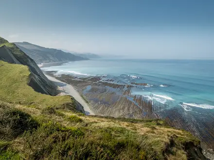
- The Meseta: The long, flat tableland between Burgos and Leon is exposed, quiet and mentally demanding, with big skies and little shade.
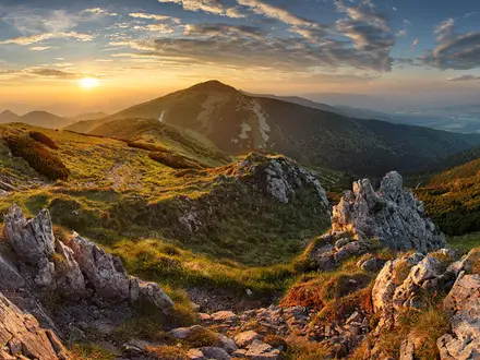
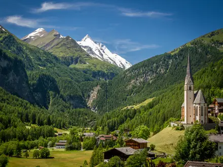
- Cruz de Ferro: Near Foncebadon, this iron cross and stone cairn marks the symbolic high point of the route at about 1,505 m.
- O Cebreiro and Santiago de Compostela: O Cebreiro is the steep entry into Galicia; the journey ends at the Cathedral of Santiago de Compostela in the Praza do Obradoiro.
Challenges to expect
The Camino Francés is well marked and well supplied, but the distance is the real test: 33-35 days of repeated 23-25 km walking. The first Pyrenees stage to Roncesvalles is the hardest, and the climb to O Cebreiro is another strenuous day. The Meseta is flat but exposed, hot in summer and mentally tiring. Winter can bring snow on the Pyrenees and O Cebreiro, with some albergues closed.
HikeList Score
Camino de Santiago (Camino Francés) scored 80/100 on HikeList's trail-quality metrics.
See score breakdownHide breakdown
- Ideal length 52
- Balanced challenge 100
- Scenery & wildness 66
- Varied terrain 100
- Accommodation 84
- Food & support 88
- Path quality 92
- Season flexibility 76
Computed from length, challenge, scenery & wildness, terrain variety, accommodation, food & support, path quality and season flexibility.
Show more data Show less
- Mountainous
- Farmland
- Vineyards
- Plains
- Hilly
- Mountain Footpaths
- Dirt Tracks
- Gravel Tracks
- Roman Roads
- Cobbled Streets
- Paved Roads
- Senda
- Albergues
- Hostales
- Pensiones
- Hotels
- Family Friendly
- Pet Friendly
- Water Sources
- Campsites
- Shelters
- Restrooms
Download Our Full Guide to Camino de Santiago (Camino Francés) FREE!
Get our comprehensive guide to this hike for free. Save it for later reading or print out at home.
Articles related to this hike
In these collections
Photos from hikers
Taken on the trail by people who've reviewed Camino de Santiago (Camino Francés).
Camino de Santiago (Camino Francés): The Complete Guide
Recommended Itinerary
The most practical full Camino Francés schedule is a 34-walking-day itinerary from Saint-Jean-Pied-de-Port (Donibane Garazi) to Santiago de Compostela. It keeps most days in the 20–25 km range, but there are several longer stages where the spacing of traditional pilgrim stops makes a neat split less straightforward.
Most walkers should add rest or short days rather than trying to compress the route. Pamplona (Iruña), Burgos, León and possibly Logroño or Astorga are the most obvious places to pause because they sit naturally on the line of the route and have wider accommodation options.
Standard itinerary: 34 walking days
| Day | From | To | Approx. distance | Why this stage makes sense | Services/accommodation notes |
|---|---|---|---|---|---|
| 1 | Saint-Jean-Pied-de-Port | Roncesvalles | 25 km | The classic opening crossing of the Pyrenees, traditionally via the Route Napoléon in suitable conditions. It is one of the hardest days of the whole Camino, so start early and avoid treating it as a gentle warm-up. | Roncesvalles (Orreaga) is the natural first overnight stop in Spain. The high Route Napoléon is officially closed roughly 1 November–31 March, when the Valcarlos route is used; this should be checked before travelling. |
| 2 | Roncesvalles | Zubiri | 22 km | A useful second day through the Navarrese foothills, allowing legs to adapt after the Pyrenees without pushing all the way to Pamplona. | Burguete (Auritz) and Espinal (Aurizberri) break up the early part of the day. Zubiri is a standard pilgrim stop; check albergue openings outside the main season. |
| 3 | Zubiri | Pamplona | 21 km | A moderate approach into Pamplona, with the route passing Larrasoaña and Trinidad de Arre before reaching the city. | Pamplona (Iruña) has the widest range of services so far and is a good first place for a rest night if needed. Book ahead in busy periods. |
| 4 | Pamplona | Puente la Reina | 24 km | This stage crosses the Alto del Perdón, one of the first major landmarks after Pamplona, before descending towards the joining point of the Navarrese and Aragonese Caminos. | Cizur Menor is an early waypoint after Pamplona. Puente la Reina (Gares) is a major Camino town with established pilgrim accommodation. |
| 5 | Puente la Reina | Estella | 22 km | A steady Navarra stage through historic Camino country, with Cirauqui as a notable intermediate village. | Estella (Lizarra) is a useful resupply and overnight town before the vineyards and smaller stops beyond. |
| 6 | Estella | Los Arcos | 21 km | A manageable day that passes the Monasterio de Irache and the Fuente del Vino before continuing west towards Los Arcos. | Los Arcos is a traditional overnight stop. Services become more spread out than in the larger towns, so check the next day’s options before leaving. |
| 7 | Los Arcos | Logroño | 28 km | A longer day through Sansol and Torres del Río before entering La Rioja and reaching Logroño. It is a logical push because Logroño is the next major city. | Logroño has extensive accommodation and food options and is a sensible place to recover after the first week. |
| 8 | Logroño | Nájera | 29 km | Another longer stage through La Rioja, passing Navarrete and continuing through vineyard country to Nájera. | Nájera is a standard Camino overnight. If walking in heat, this is a day to start early because the distance is close to 30 km. |
| 9 | Nájera | Santo Domingo de la Calzada | 21 km | A shorter recovery day after the two longer stages into and out of Logroño, with Azofra on the route. | Santo Domingo de la Calzada is a well-established pilgrim town with a range of services. |
| 10 | Santo Domingo de la Calzada | Belorado | 22 km | A balanced stage through Grañón towards Belorado, continuing the gradual transition towards Castilla y León. | Belorado is the natural overnight stop before the Montes de Oca section. Check seasonal accommodation opening if walking outside spring to autumn. |
| 11 | Belorado | San Juan de Ortega | 24 km | This positions the walker close to Burgos while keeping the day manageable, passing Villafranca Montes de Oca before San Juan de Ortega. | San Juan de Ortega is a smaller pilgrim stop than Burgos; if accommodation is tight, nearby Agés and Atapuerca are also on the route sequence. |
| 12 | San Juan de Ortega | Burgos | 27 km | A longer approach into one of the route’s major cities, passing Agés and Atapuerca before the final entry to Burgos. | Burgos has extensive accommodation, transport and resupply options. It is one of the best places for a rest day before the Meseta. |
| 13 | Burgos | Hornillos del Camino | 20 km | A sensible first Meseta day after Burgos, short enough to ease into the exposed tableland section. | Hornillos del Camino is a traditional pilgrim stop. On the Meseta, do not rely on frequent shade; carry enough water for the day’s conditions. |
| 14 | Hornillos del Camino | Castrojeriz | 20 km | Another controlled Meseta stage, with Hontanas providing a key intermediate village before Castrojeriz. | Castrojeriz is a standard overnight before the next day towards Frómista. Accommodation is available on the Camino network, but openings should be checked in winter. |
| 15 | Castrojeriz | Frómista | 25 km | A longer but logical Meseta stage through Itero de la Vega and Boadilla del Camino to Frómista. | Frómista is an established pilgrim town. This is a day where heat and exposure can matter more than technical difficulty. |
| 16 | Frómista | Carrión de los Condes | 19 km | A shorter day that keeps the body fresh before one of the more sparsely spaced Meseta stretches. | Villalcázar de Sirga lies before Carrión de los Condes. Carrión is an important place to resupply and plan the following day carefully. |
| 17 | Carrión de los Condes | Calzadilla de la Cueza | 17 km | A short but useful stage across the open Meseta, often valued because the spacing of stops makes alternatives less convenient. | Calzadilla de la Cueza is a smaller overnight stop. Confirm accommodation availability before committing, especially outside the main season. |
| 18 | Calzadilla de la Cueza | Sahagún | 22 km | A moderate stage that completes another section of the Meseta and reaches Sahagún, a larger service point. | Sahagún has better services than the smaller villages before it and is a practical resupply stop. |
| 19 | Sahagún | El Burgo Ranero | 18 km | A deliberately moderate day after Sahagún, keeping the Meseta crossing sustainable rather than forcing a long push. | Bercianos del Real Camino is on this section. El Burgo Ranero is a standard Camino overnight, but check openings in quieter months. |
| 20 | El Burgo Ranero | Mansilla de las Mulas | 19 km | A straightforward stage through Reliegos to Mansilla de las Mulas, setting up a short approach to León. | Mansilla de las Mulas is the natural stop before León. Staying here allows an easier next morning into the city. |
| 21 | Mansilla de las Mulas | León | 18 km | A shorter day into León, allowing time for accommodation, laundry, resupply and recovery on arrival. | León is one of the best rest-day points on the Camino Francés, with extensive services and onward transport connections. |
| 22 | León | Villar de Mazarife | 21 km | A measured restart after León, avoiding an overlong first day out of the city. | Villar de Mazarife is a recognised Camino stop. Check current accommodation options before booking, as smaller-stage choices can vary by season. |
| 23 | Villar de Mazarife | Astorga | 31 km | A long but commonly used stage that passes Hospital de Órbigo and reaches Astorga, a major town before the Montes de León. | Astorga has a wide range of services and is a strong place to resupply before the climb towards Rabanal del Camino and Cruz de Ferro. |
| 24 | Astorga | Rabanal del Camino | 20 km | A shorter climbing day into the Montes de León, positioning the walker well for the high ground around Cruz de Ferro. | Rabanal del Camino is a standard pilgrim overnight before the high section. Weather should be checked before continuing towards Cruz de Ferro. |
| 25 | Rabanal del Camino | Ponferrada | 32 km | One of the toughest standard days: it crosses the symbolic high point at Cruz de Ferro near Foncebadón and Manjarín, then descends through El Acebo and Molinaseca to Ponferrada. | This is a long mountain-and-descent stage. Ponferrada has extensive accommodation and services; consider splitting this day if conditions, knees or pack weight make the descent too much. |
| 26 | Ponferrada | Villafranca del Bierzo | 24 km | A manageable day through the El Bierzo valley, passing Cacabelos before Villafranca del Bierzo. | Villafranca del Bierzo is the key overnight before the demanding approach to O Cebreiro. Resupply here and check the weather for the climb into Galicia. |
| 27 | Villafranca del Bierzo | O Cebreiro | 28 km | A hard but important mountain stage, climbing via Trabadelo and La Faba to the Galician gateway of O Cebreiro. | O Cebreiro is a smaller high-level stop and can be affected by poor weather. Accommodation should be checked ahead in winter and shoulder seasons. |
| 28 | O Cebreiro | Triacastela | 21 km | A shorter day after the climb, crossing Alto do Poio before descending towards Triacastela. | Triacastela is a standard Galician overnight. Expect damper, greener conditions than on the Meseta. |
| 29 | Triacastela | Sarria | 18 km | A short stage into Sarria, allowing an easier day before the busier final 100 km section begins. | Sarria is the main starting point for pilgrims walking the minimum final 100 km for the Compostela. From here to Santiago, expect more competition for beds in peak periods. |
| 30 | Sarria | Portomarín | 22 km | A classic first stage of the final 100 km, passing Barbadelo before reaching Portomarín above the Miño reservoir. | Portomarín is a major final-week stop. Book ahead in July–August or if arriving late in the day. |
| 31 | Portomarín | Palas de Rei | 25 km | A steady Galician hill stage, long enough to keep the final week on schedule without becoming excessive. | Palas de Rei is a standard overnight with pilgrim infrastructure. The route is busier here than earlier on the Camino. |
| 32 | Palas de Rei | Arzúa | 29 km | A longer final-week stage through Melide to Arzúa, joining one of the busiest corridors of the route. | Melide is a key intermediate town. Arzúa has many pilgrim services, but advance planning is sensible in peak summer. |
| 33 | Arzúa | O Pedrouzo | 20 km | A controlled penultimate day that keeps the final walk into Santiago to a comfortable distance. | O Pedrouzo (Arca / O Pino) is the standard last overnight stop before Santiago. It can be busy, so booking is useful in peak periods. |
| 34 | O Pedrouzo | Santiago de Compostela | 20 km | The final stage passes Monte do Gozo before descending into Santiago and the Praza do Obradoiro at the Catedral de Santiago de Compostela. | Santiago has extensive accommodation, rail, bus and airport links. Allow time for the Pilgrims’ Reception Office if collecting the Compostela. |
Slower itinerary: who it suits
A slower schedule suits first-time long-distance walkers, anyone carrying a full pack, summer walkers on the Meseta, and pilgrims who want rest days in the major cities. Plan for at least 38–42 days overall by inserting rest days and splitting the hardest long stages.
The most sensible places to slow down are:
- Day 1 over the Pyrenees: consider breaking the Saint-Jean-Pied-de-Port to Roncesvalles stage at Orisson if accommodation is available. This should be booked and checked before travelling.
- Logroño to Nájera and Los Arcos to Logroño: both are close to 30 km in the standard itinerary, so tired walkers may prefer shorter intermediate stops where accommodation is available.
- Villar de Mazarife to Astorga: the standard day is 31 km; Hospital de Órbigo is on the route and can make a more comfortable split.
- Rabanal del Camino to Ponferrada: the standard day is 32 km and includes the high ground around Cruz de Ferro plus a long descent. Splitting around Foncebadón, El Acebo or Molinaseca can make the stage more forgiving, depending on current accommodation availability.
- Villafranca del Bierzo to O Cebreiro: the climb into Galicia is demanding. Trabadelo and La Faba are on the route and can help create a shorter approach before the final climb.
- Palas de Rei to Arzúa: at 29 km, this is a long day in the busy final section. Melide is the main intermediate town.
For a slower itinerary, do not assume every smaller place has year-round beds. Albergue opening seasons vary, particularly in winter and shoulder months, so each split should be checked before travelling.
Faster itinerary: who it suits
A faster schedule is only sensible for fit, experienced walkers who already know they can repeat 25–35 km days for several weeks. The Camino Francés is non-technical, but compressing it increases the risk of blisters, tendon problems and fatigue, especially on the Meseta and on the long descents after Cruz de Ferro.
Faster walkers usually save time by combining selected shorter days rather than rushing the mountain stages. The easiest candidates are the more moderate Meseta stages between Burgos and León, and some of the shorter days such as Frómista to Carrión de los Condes, Carrión de los Condes to Calzadilla de la Cueza, Sahagún to El Burgo Ranero, El Burgo Ranero to Mansilla de las Mulas, and Mansilla de las Mulas to León.
Exact combined distances depend on the chosen overnight stops and variants, so official mapping should be checked before booking. Even on a faster plan, keep contingency time for the Route Napoléon closure or bad weather, heavy heat on the Meseta, and accommodation pressure from Sarria to Santiago.
Planning the Route
How many days to allow
Most walkers should plan on at least four to five weeks from Saint-Jean-Pied-de-Port (Donibane Garazi) to Santiago de Compostela. The classic schedule uses roughly 33 walking stages, with daily distances commonly around 20–25 km, though several days are longer.
A practical plan is to allow 33–35 days in total, then add rest or buffer days if time allows. Burgos, León, Logroño, Astorga and Santiago de Compostela are natural places to pause because they have more services and transport options than the smaller Camino villages.
Walking the Camino Francés too fast usually creates more problems than it solves. The route is not technically difficult, but repeated long days on hard tracks, tarmac, cobbles and roadside senda can quickly cause foot, knee and tendon issues. A steadier pace is usually more sustainable than trying to gain time early.
Using the standard stages
The standard stage pattern exists because accommodation, food and services are spaced around historic pilgrim towns and villages. For many walkers, it is simplest to follow the established stages at first, then adapt after Pamplona or Logroño once the body has settled into a rhythm.
Several stages are naturally more demanding and deserve extra attention when planning:
| Section | Planning issue |
|---|---|
| Saint-Jean-Pied-de-Port to Roncesvalles | A hard, exposed Pyrenees crossing on the Route Napoléon; use the Valcarlos alternative in bad weather or when the high route is closed in winter. |
| Los Arcos to Logroño and Logroño to Nájera | Longer days in the La Rioja section; start early in hot weather. |
| Burgos to León | The Meseta is flat but exposed, with long, mentally demanding days and limited shade. |
| Rabanal del Camino to Ponferrada | High ground around Cruz de Ferro, followed by a long descent towards El Acebo, Molinaseca and Ponferrada. |
| Villafranca del Bierzo to O Cebreiro | One of the key climbing days, with the steep ascent into Galicia. |
| Sarria to Santiago | Busier from Sarria onwards because it is the minimum walking distance commonly used by pilgrims seeking the Compostela. |
The published stages are not compulsory. In the better-served sections, especially before and after the large cities, it is usually possible to stop earlier or continue to the next village. In thinner stretches, particularly parts of the Meseta and the mountain approaches, daily options are more dictated by where albergues and food are available.
Fast, slow or flexible pacing
A fast Camino Francés suits fit walkers who are already used to consecutive 25–30 km days with a loaded pack. Even then, the first week should not be treated as a warm-up sprint: the Pyrenees, the descent to Zubiri and the climb over Alto del Perdón all come before most bodies have adapted to daily walking.
A slower schedule is often the better choice for a first long-distance pilgrimage. Shorter days make it easier to manage blisters, wash and dry kit, arrive before the albergue rush and still have time for food shopping or a proper meal.
A flexible itinerary works best if accommodation has not all been pre-booked. Build in the ability to stop short after hard weather, extend an easy day when the legs are strong, or take an unplanned rest day in a city.
Accommodation planning
The Camino Francés has the densest pilgrim infrastructure of any Camino route, but accommodation still needs active planning. Options include municipal, parish or donativo albergues, private albergues, pensiones, hostales, casas rurales and hotels in larger towns.
Municipal albergues are usually the cheapest and simplest pilgrim option, typically costing a few euros to around €10–15, but prices and opening arrangements change. Confirm current prices before booking or relying on a specific albergue.
In high season, beds can fill in popular stopping places. This is especially relevant from Sarria to Santiago, where many more walkers join for the final stretch. Booking ahead is sensible if arriving late, walking in a group, needing a private room, or travelling during the busiest periods.
Winter and shoulder-season walkers need a different strategy. Some albergues close outside the main season, especially on the Pyrenees and in Galicia, so each night’s stop should be checked before travelling.
Food and water planning
Food planning is generally straightforward compared with more remote long-distance trails. The route passes frequent villages and towns, many with cafés, shops, pilgrim menus and basic resupply.
Do not assume every small village has open services all day. Carry enough food for the day’s walking, particularly across the Meseta, on longer stages, and when starting early before cafés open.
Water is normally managed stage by stage rather than as a wilderness problem, but the exposed Meseta and hot summer conditions make carrying extra capacity sensible. Long, shadeless sections are harder than the map profile suggests.
Navigation and route finding
Navigation is one of the easier parts of planning the Camino Francés. The French section follows the GR 65, and the Spanish route is marked with yellow arrows and scallop-shell markers.
Even so, carry an offline map or guide information for each day. Waymarks can be missed in towns, at road junctions or when leaving large cities such as Pamplona, Burgos and León, and a phone map is useful for finding accommodation away from the main line of the route.
Weather and seasonal planning
Season choice affects the itinerary more than the navigation. Spring and autumn usually offer the best balance of walking conditions and services, while July and August can be very hot on the Meseta and busier overall.
The Route Napoléon over the Pyrenees is officially closed roughly 1 November to 31 March. During that period, and whenever conditions are poor, walkers should use the lower Valcarlos route instead. This should be checked before travelling.
Winter is possible but needs more planning. Snow can affect the Pyrenees and the O Cebreiro area, daylight is shorter, and accommodation openings are less reliable.
Credencial, stamps and the Compostela
The Camino Francés does not require a hiking permit, but pilgrims who want the Compostela certificate in Santiago need a credencial and must collect stamps, or sellos, along the way. The credencial can be obtained before travelling or at the start in Saint-Jean-Pied-de-Port.
To qualify for the Compostela when walking, the final 100 km on foot must be completed; on the Camino Francés this is why Sarria is such a common starting point. Current Compostela and credencial requirements should be checked with the Pilgrims’ Reception Office before travelling.
Shortening, extending and section hiking
The Camino Francés is very practical to section-hike. Major towns and cities such as Pamplona, Logroño, Burgos, León, Ponferrada, Sarria and Santiago de Compostela make useful access or exit points, though exact transport connections should be checked before booking.
Common shorter plans include walking from Sarria to Santiago for the final 100 km, starting in a Spanish city such as Pamplona or León, or dividing the full route into two or three trips. This works well because waymarking and pilgrim services continue throughout the route rather than being concentrated only at the start and finish.
Extending beyond Santiago is a separate trip rather than part of the Camino Francés itself. If extra time is available, it is usually better to protect the main itinerary first with a rest or buffer day than to plan the core route too tightly.
Towns, Villages and Overnight Stops
The Camino Francés is one of Europe’s best-supported long-distance walks, with pilgrim albergues, cafés and basic services appearing regularly along most of the route. Standard stage ends almost always have some form of pilgrim accommodation, while the larger towns add pensiones, hostales, hotels, pharmacies, supermarkets and better transport options.
Accommodation availability changes sharply by season. Some albergues close in winter and shoulder-season walkers should check opening dates before committing to a stage; in July and August, and especially from Sarria onwards, bed competition can be significant. Municipal albergues are usually the cheapest option, commonly a few euros to around €10–15, while private albergues and rooms cost more; current prices should be checked before booking.
Most pilgrims use the credencial at overnight stops to collect sellos. From Sarria to Santiago, this becomes especially important because walkers need proof of completing at least the final 100 km on foot to qualify for the Compostela.
Saint-Jean-Pied-de-Port (Donibane Garazi)
Saint-Jean-Pied-de-Port is the traditional starting town at the foot of the Pyrenees, where most walkers collect the credencial and begin from the Porte Saint-Jacques / rue de la Citadelle. It is a practical place to arrive at least the afternoon before starting, as the first stage over the Pyrenees is long, steep and exposed.
There is pilgrim accommodation and other lodgings in town, plus the services needed for final preparation: food, basic resupply and last checks before crossing into Spain. Saint-Jean is reached by SNCF/TER train from Bayonne, with Bayonne linked onwards to airports including Biarritz, Pau and Bordeaux; current rail and shuttle arrangements should be checked before travelling.
Orisson
Orisson sits on the Route Napoléon between Saint-Jean-Pied-de-Port and Roncesvalles. It is mainly important because it allows the demanding first Pyrenees crossing to be split, reducing the risk of starting the Camino with an over-hard day.
Accommodation is limited compared with the larger stage towns, so it should not be treated as a flexible, turn-up-and-see stop in busy periods. If planning to stop here, book ahead and confirm opening dates, especially outside the main walking season.
Roncesvalles (Orreaga)
Roncesvalles is the first standard overnight stop in Spain after the Pyrenees crossing. For many walkers it is a sensible end point after the Route Napoléon, rather than pushing on tired after the hardest opening day.
The village is centred on its historic monastery and pilgrim facilities. Food and services are more limited than in a town, so it is better treated as a recovery stop than a resupply hub. In poor weather or winter, walkers may arrive via the lower Valcarlos alternative rather than the high route.
Burguete (Auritz) and Espinal (Aurizberri)
Burguete and Espinal lie shortly after Roncesvalles on the descent towards Zubiri. They are useful early-route villages for spacing the second stage more gently, particularly for walkers who split the first day or want a shorter start to the Spanish section.
Accommodation and food options should be checked before relying on either village as an overnight stop. They are more practical as small Camino service points than as major resupply locations.
Zubiri
Zubiri is the usual stage end after Roncesvalles and a natural second overnight stop on the standard itinerary. It sits before the approach to Pamplona, making the following day into the city manageable.
Pilgrim accommodation is normally available, with basic food services geared to walkers. As with all smaller stage towns, winter opening dates should be checked in advance.
Larrasoaña and Trinidad de Arre
Larrasoaña and Trinidad de Arre sit between Zubiri and Pamplona. They are useful for shortening or adjusting the Zubiri–Pamplona stage, especially if beds in Zubiri are tight or if the first few days have taken a toll.
These are not major towns, so expect fewer choices than in Pamplona. Check accommodation and food availability if planning to stop rather than pass through.
Pamplona (Iruña)
Pamplona is the first major city on the Camino Francés and one of the best places for an early rest, gear adjustment or medical stop. It comes after the initial Pyrenees and Navarra stages, when many walkers are still refining pack weight, footwear and daily rhythm.
Accommodation choice is much broader than in the villages, from pilgrim beds to private rooms and hotels. Food, shops, pharmacies and other city services are readily available, making it a strong resupply point before continuing towards Alto del Perdón and Puente la Reina.
Cizur Menor and Alto del Perdón
Cizur Menor sits on the way out of Pamplona and can be used to shorten the climb towards Alto del Perdón. The ridge itself is a landmark rather than an overnight stop, known for its pilgrim sculpture and wind turbines.
Plan food and water around this section rather than assuming substantial services on the ridge. Most walkers continue to Puente la Reina, but Cizur Menor can be useful for those leaving Pamplona late or easing back into walking after a rest day.
Puente la Reina (Gares)
Puente la Reina is a key Camino town where the Navarrese and Aragonese routes meet. It is a strong overnight stop, with established pilgrim infrastructure and the Romanesque bridge over the Río Arga marking one of the classic points of the route.
Accommodation and food are generally geared to pilgrims. It is also a sensible place to reassess pacing after the first four walking days, as the route continues through smaller settlements towards Estella.
Cirauqui
Cirauqui lies between Puente la Reina and Estella. It is mainly useful as an intermediate service point or as a way to break the stage if needed.
Do not assume the range of facilities found in larger stage towns. If planning an overnight here, confirm accommodation and food before committing to the day’s mileage.
Estella (Lizarra)
Estella is a substantial and useful overnight stop before the route passes the Monasterio de Irache and the Fuente del Vino. It is well placed for resupply and for dealing with practical needs before the quieter stretch to Los Arcos.
Pilgrims will usually find more choice here than in the surrounding villages, including albergues and private accommodation. It is a sensible place to buy food for the next day if walking early, as services can be more spread out after leaving town.
Monasterio de Irache and Los Arcos
The Monasterio de Irache is passed soon after Estella and is best known for the Fuente del Vino run by Bodegas Irache. It is a landmark rather than a standard overnight base for most walkers.
Los Arcos is the usual stage end after Estella and is the practical overnight stop on this section. Expect pilgrim accommodation and basic food services, but check opening dates outside the main season.
Sansol and Torres del Río
Sansol and Torres del Río sit between Los Arcos and Logroño. They are useful for splitting the long Los Arcos–Logroño stage, which is one of the longer days in the standard itinerary.
Facilities are more limited than in Logroño, but these villages can be valuable if heat, fatigue or bed availability make the full stage unattractive. Confirm accommodation before relying on them as overnight stops.
Logroño
Logroño is the main city of La Rioja and one of the best resupply and rest options before the route continues through vineyard country. It sits after the long stage from Los Arcos and gives access to a much wider range of accommodation and food than the nearby villages.
The city is known for Calle Laurel, a useful concentration of tapas bars for walkers wanting a proper meal after several rural stages. It is also a practical place for pharmacies, gear replacement and rest before continuing towards Navarrete and Nájera.
Navarrete
Navarrete lies between Logroño and Nájera and can be used to shorten what is otherwise a long stage. It is a sensible intermediate stop for walkers who prefer consistent 20–25 km days or who leave Logroño late.
Accommodation and services are more limited than in Logroño or Nájera, so availability should be checked if planning to sleep here. It is also a useful food or rest stop when passing through.
Nájera
Nájera is the standard overnight after Logroño on the classic itinerary. It provides a practical stage end before the route continues towards Azofra and Santo Domingo de la Calzada.
Pilgrim accommodation and food services are normally part of the Camino infrastructure here. It is a reasonable place to resupply before heading into the next sequence of smaller Rioja and Castilla y León towns.
Azofra
Azofra lies between Nájera and Santo Domingo de la Calzada. It is useful as a shorter-stage option, particularly for walkers managing blisters, heat or fatigue.
Treat it as a small Camino stop rather than a full-service town. Accommodation and food availability should be checked before travelling, especially outside peak season.
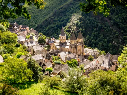
Santo Domingo de la Calzada
Santo Domingo de la Calzada is a major stage town on the route through La Rioja. It is a practical overnight stop with better services than the smaller villages before and after it.
This is a good place for food, accommodation and routine resupply before continuing towards Grañón and Belorado. Walkers wanting to adjust the standard schedule can use it as a reliable anchor point.
Grañón
Grañón sits between Santo Domingo de la Calzada and Belorado. It is a useful stop for splitting the day, particularly for walkers who prefer village overnights to larger towns.
Facilities are limited compared with Santo Domingo or Belorado. Check bed and food availability before planning the stage around it.
Belorado
Belorado is the usual overnight stop after Santo Domingo de la Calzada. It marks a practical staging point before the route rises towards Villafranca Montes de Oca and San Juan de Ortega.
Accommodation and food options are normally available for pilgrims. It is a sensible place to prepare for the following day, which moves into a less urban section before Burgos.
Villafranca Montes de Oca, San Juan de Ortega, Agés and Atapuerca
This chain of settlements lies between Belorado and Burgos. San Juan de Ortega is the standard stage end on the classic itinerary, while Villafranca Montes de Oca, Agés and Atapuerca can help vary the day length.
Facilities are more limited than in Burgos or Belorado, so this is a section where checking accommodation ahead is wise. San Juan de Ortega is useful for keeping the standard stages balanced, but walkers wanting more choice may continue or stop differently depending on bed availability.
Burgos
Burgos is one of the major cities of the Camino Francés and an obvious rest or resupply point. It comes immediately before the long Meseta section, so it is a good place to sort footwear, pack issues, laundry, pharmacy needs and food before the more exposed walking begins.
Accommodation ranges well beyond pilgrim albergues, with private rooms and hotels available in the city. The Catedral de Burgos is a major landmark, but from a planning perspective the city’s main value is its services and its position before several quieter stages.
Tardajos and Hornillos del Camino
Tardajos sits soon after Burgos, while Hornillos del Camino is the standard first Meseta overnight on the classic itinerary. This is where the route begins to feel more open and exposed, with longer stretches between larger service centres.
Hornillos is a useful stop, but it is small compared with Burgos. In hot weather or peak season, do not assume unlimited beds or flexible food options; check ahead and carry what is needed for the day.
Hontanas and Castrojeriz
Hontanas is an important small village in the Meseta section and can be used to split the stage between Hornillos del Camino and Castrojeriz. Castrojeriz is the standard overnight stop and a stronger base for services.
Both are useful in managing Meseta pacing, especially in summer when early starts and shorter afternoons can be preferable. Accommodation should be checked in busy or off-season periods, as options are more concentrated than in the cities.
Itero de la Vega, Boadilla del Camino and Frómista
These settlements sit between Castrojeriz and Frómista. Itero de la Vega and Boadilla del Camino can be used to break up the day, while Frómista is the standard stage end.
Frómista is the more practical overnight base, with established pilgrim services and better onward staging towards Carrión de los Condes. The smaller villages are useful, but bed and food availability should be checked if planning to stop.
Villalcázar de Sirga and Carrión de los Condes
Villalcázar de Sirga sits before Carrión de los Condes and can be useful for a pause or a shorter day. Carrión de los Condes is the standard overnight and an important planning point on the Meseta.
This is a sensible place to resupply before the next stage to Calzadilla de la Cueza. Services become more spaced out on parts of the Meseta, so walkers should leave Carrión with enough food and water for the day rather than relying on frequent shops.
Calzadilla de la Cueza
Calzadilla de la Cueza is the classic stage end after Carrión de los Condes. It is a small but strategically important overnight stop because it breaks the exposed Meseta walking into manageable sections.
Facilities are limited, so it is not the place to expect wide choice. Check accommodation opening and carry adequate supplies from Carrión, particularly in hot weather or outside the main season.
Sahagún
Sahagún is a larger and more useful stop after Calzadilla de la Cueza. It works well for resupply and recovery before continuing across the remaining Meseta stages towards León.
Pilgrim accommodation and food services are normally available, with more choice than in the smaller villages around it. It is a good point to review pacing before the sequence through Bercianos del Real Camino, El Burgo Ranero and Mansilla de las Mulas.
Bercianos del Real Camino and El Burgo Ranero
Bercianos del Real Camino and El Burgo Ranero sit between Sahagún and Mansilla de las Mulas. El Burgo Ranero is the standard stage end, while Bercianos can be useful for adjusting distance.
This is still Meseta walking, with limited shade and a quiet, spread-out feel. Check accommodation and food before relying on either village in winter or shoulder season.
Reliegos and Mansilla de las Mulas
Reliegos lies before Mansilla de las Mulas and is useful as an intermediate stop or break. Mansilla de las Mulas is the standard overnight before the approach to León.
Mansilla is the more practical base, with pilgrim accommodation and food services. It is a sensible place to stop before the final walk into León rather than arriving in the city late and tired.
León
León is one of the most important service stops on the Camino Francés. It comes after the long Meseta crossing and is an obvious place for a rest day, medical check, proper laundry, gear replacement and a change of pace.
Accommodation choice is broad, from pilgrim options to hotels. Food and city services are extensive, and the Catedral de León is a major landmark, but walkers should primarily use León to prepare for the hillier stages ahead towards Astorga, the Montes de León and Cruz de Ferro.
Villar de Mazarife and Hospital de Órbigo
Villar de Mazarife is the standard overnight after León on the listed itinerary. Hospital de Órbigo lies before Astorga and is another useful staging point, especially for walkers adjusting the long León–Astorga section.
The stage to Astorga can be long if walked in one push from Villar de Mazarife, so accommodation planning matters here. Check beds and food availability if changing from the standard stage pattern.
Astorga
Astorga is a major and very practical stop before the climb into the Montes de León. It has more services than the villages ahead, making it a good place to resupply, rest and prepare for cooler, higher ground.
Accommodation options are broader than in the mountain villages, and food services are well suited to pilgrims. The town’s cathedral, Roman walls and Gaudí’s Palacio Episcopal are landmarks, but its main planning value is as the last substantial town before Rabanal del Camino, Foncebadón and Cruz de Ferro.
Rabanal del Camino
Rabanal del Camino is the standard overnight after Astorga and a strategic stop before the high point area around Cruz de Ferro. It is a sensible place to finish the day rather than pushing too far into the higher settlements late in poor weather.
Pilgrim accommodation is part of the route infrastructure, but availability should be checked outside the main season. Weather can feel more mountain-like from here onwards, so use the stop to reassess layers, food and timing.
Foncebadón, Cruz de Ferro and Manjarín
Foncebadón sits before Cruz de Ferro and can be used as an alternative overnight to Rabanal del Camino. Cruz de Ferro itself is a symbolic high point rather than an overnight stop, while Manjarín lies just beyond the crest area.
This is one of the most exposed and elevated parts of the Camino Francés, so accommodation and weather checks matter more than they do on the lower Meseta. Do not plan around finding full services at Cruz de Ferro; it is a landmark on the walking day, not a town stop.
El Acebo and Molinaseca
El Acebo and Molinaseca lie on the descent from the Cruz de Ferro area towards Ponferrada. They are useful for splitting the long Rabanal del Camino–Ponferrada stage, which is one of the longest in the standard itinerary.
Both can help make the mountain descent more manageable, particularly in poor weather or if knees and feet are suffering. Check accommodation if planning to stop, as many walkers use these villages to avoid an overlong day into Ponferrada.
Ponferrada
Ponferrada is a major overnight stop at the entrance to the El Bierzo valley. It is a strong resupply and recovery point after the Montes de León and before the route heads towards Villafranca del Bierzo and the climb to O Cebreiro.
Accommodation choice is better than in the surrounding villages, and food and practical services are readily available. The Castillo de los Templarios is the main landmark, but the town’s value for walkers is its ability to reset before the next mountain approach.
Cacabelos and Villafranca del Bierzo
Cacabelos lies between Ponferrada and Villafranca del Bierzo and is useful for shortening or adjusting the day. Villafranca del Bierzo is the standard overnight and the key staging point before the climb towards O Cebreiro.
Villafranca is an important place to check weather, food and accommodation for the following day. The next stage is demanding, so it is better to leave with a clear plan rather than assuming the climb can be improvised late in the day.
Trabadelo and La Faba
Trabadelo and La Faba lie on the approach to O Cebreiro. They are strategically useful for splitting the hard Villafranca del Bierzo–O Cebreiro stage, especially for walkers who want to tackle the steepest climbing earlier in the day.
Facilities are more limited than in Villafranca or the larger Galician towns. Accommodation should be checked carefully if planning to stop, particularly outside the main season or in unsettled weather.
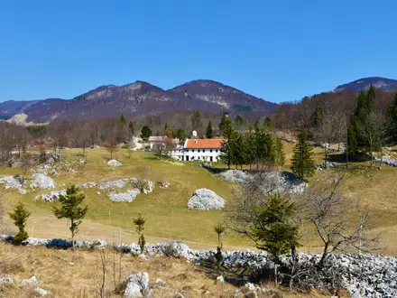
O Cebreiro
O Cebreiro is the mountain gateway into Galicia and one of the most important overnight stops on the Camino Francés. It follows a steep climb and sits high enough for weather to be a serious planning factor, especially in winter when snow risk can affect this section.
Pilgrim accommodation is available, but demand can be high because of the village’s location and significance. Check openings and conditions before relying on it in winter or shoulder season. Its pallozas and the church of Santa María la Real make it memorable, but practical planning should focus on warmth, food and an early enough arrival.
Alto do Poio and Triacastela
Alto do Poio lies after O Cebreiro, while Triacastela is the standard overnight stop on the descent through Galicia. This section can feel very different from the Meseta, with greener, damper hill country and more changeable weather.
Triacastela is the practical base for the night and the point where walkers choose how to continue towards Sarria, including the route through Samos. Check accommodation if walking outside the main season, as some Galician albergues close in winter.
Samos
Samos lies on the route option between Triacastela and Sarria. It is useful for walkers who want to vary the standard stage and include the monastery town rather than taking the most direct line.
Treat it as an alternative staging choice rather than a compulsory stop. Accommodation and food availability should be checked before choosing the variant, especially if timing the walk to meet bookings farther along the route.
Sarria
Sarria is the main starting point for pilgrims walking the final 100 km to Santiago. From here onwards the Camino becomes noticeably busier, especially in peak summer, because walkers starting here can qualify for the Compostela by completing the remaining distance on foot and collecting the required sellos.
Accommodation is plentiful overall, but competition for beds is also much stronger than earlier on the route. Booking private accommodation or starting early can reduce stress in busy periods. Sarria is also a major practical resupply point before the final Galician stages.
Barbadelo and Portomarín
Barbadelo sits shortly after Sarria and can be used to shorten the first day out of town. Portomarín is the standard overnight and one of the key stops on the final 100 km.
Portomarín has established pilgrim services and is a logical place to stop after the busy Sarria stage. Its Romanesque church of San Nicolás, moved stone by stone when the town was rebuilt above the Miño reservoir, is the main landmark, but walkers should mainly plan around bed pressure from this point onward.
Palas de Rei
Palas de Rei is the standard overnight after Portomarín. It is a practical service town on the final stretch, with pilgrim accommodation and food options serving the high volume of walkers from Sarria.
This is a good place to check onward beds, especially if walking in July or August. From here the route continues towards Melide and Arzúa, both of which see heavy pilgrim traffic.
Melide
Melide lies between Palas de Rei and Arzúa and is an important intermediate town on one of the longer final stages. Many walkers use it to split the Palas de Rei–Arzúa day, particularly if avoiding a near-30 km stage.
Accommodation and food services are generally geared to pilgrims, but demand can be high in peak season. It is one of the most useful places on the final 100 km for adjusting the schedule without leaving the Camino corridor.
Arzúa
Arzúa is the standard overnight after Palas de Rei on the listed itinerary, though some walkers shorten the day by stopping in Melide. It is a key final-stage town, with a high volume of pilgrims converging before the last two days into Santiago.
Accommodation is plentiful overall but can fill quickly in busy periods. Plan the next night in O Pedrouzo carefully, as many walkers follow the same stage pattern from here.
O Pedrouzo (Arca / O Pino)
O Pedrouzo is the usual final overnight before Santiago de Compostela. It is a functional pilgrim stop rather than a place to linger, valued because it leaves a manageable final walk to the Praza do Obradoiro.
Bed demand can be intense because so many pilgrims aim for the same last-night staging point. Booking ahead or choosing an adjusted final-stage plan can reduce pressure, particularly in peak summer.
Monte do Gozo
Monte do Gozo sits just outside Santiago and is traditionally where pilgrims first glimpse the city. It can be used as a very short final-night stop, but most walkers continue into Santiago if timing and accommodation allow.
It is best understood as a landmark and staging option rather than a necessary overnight. If planning to stop here, check current accommodation availability before relying on it.
Santiago de Compostela
Santiago de Compostela is the finish of the Camino Francés, with the route ending at the Praza do Obradoiro beside the Catedral de Santiago de Compostela. Most walkers stay at least one night to collect the Compostela, attend to onward travel and recover after the final stage.
The city has the broadest accommodation choice on the route, but it is still worth booking in busy periods. The Pilgrims’ Reception Office handles Compostela arrangements, and walkers should have the credencial with the required sellos ready. Santiago has its own airport, Santiago–Rosalía de Castro, about 11 km from the city with a shuttle bus, plus Renfe rail and Alsa long-distance bus links to Madrid and the rest of Spain; current timetables should be checked before travelling.
Getting to the Start
The Camino Francés traditionally starts in Saint-Jean-Pied-de-Port (Donibane Garazi) in the French Basque Country. Most walkers begin from the old town around the Porte Saint-Jacques / rue de la Citadelle after collecting or stamping the credencial.
Do not plan to arrive and cross the Pyrenees the same day. The first stage to Roncesvalles (Orreaga) is long, steep and exposed, and transport delays into Saint-Jean-Pied-de-Port are common enough that an overnight stop before starting is the sensible option.
By train
Saint-Jean-Pied-de-Port is reached by SNCF/TER train from Bayonne. Bayonne is the key rail gateway for the start of the Camino Francés, with onward access from places including Biarritz, Pau and Bordeaux.
Check the Bayonne–Saint-Jean-Pied-de-Port timetable carefully before booking flights or long-distance trains, as local services may not line up with late arrivals. This should be checked before travelling.
Once in Saint-Jean-Pied-de-Port, the start area is in the historic centre rather than at a remote trailhead. Allow time to walk from the station, find accommodation and visit the pilgrim office or your accommodation provider for the credencial stamp.
By bus
Seasonal shuttle services also run to Saint-Jean-Pied-de-Port, and these can be useful when train times are awkward. Availability, operating dates and booking requirements change by season, so this should be checked before travelling.
If arriving outside the main walking season, do not assume a late bus or shuttle will be available. In winter and shoulder months, build the plan around the confirmed train timetable or arrange a private transfer.
By car
Driving to Saint-Jean-Pied-de-Port is possible, but it is rarely the simplest option for a full Camino. This is a long point-to-point walk ending in Santiago de Compostela, so leaving a car at the start creates a difficult return journey across northern Spain and back into France.
If a car is being used for drop-off, the best arrangement is usually for a non-walking driver to leave after departure. If parking is needed in or near Saint-Jean-Pied-de-Port, long-stay arrangements should be checked locally before travelling; do not rely on turning up and finding suitable multi-week parking.
From the nearest airport
Biarritz is the nearest airport for Saint-Jean-Pied-de-Port. From there, most walkers route via Bayonne, then take the SNCF/TER train to Saint-Jean-Pied-de-Port.
Pau and Bordeaux are also practical airport gateways because they connect into the wider rail network towards Bayonne. Bilbao and Pamplona can also work for some itineraries, but onward connections to Saint-Jean-Pied-de-Port need more care and should be checked before booking.
For awkward flight times, taxis or private transfers from Biarritz, Bayonne or nearby towns may be an option. Prices, availability and whether the service crosses the required route should be confirmed in advance.
Where to stay before starting
Stay in Saint-Jean-Pied-de-Port the night before walking. It gives enough time to collect or stamp the credencial, buy food for the first day, check the weather and choose between the Route Napoléon and the lower Valcarlos alternative if conditions require it.
Accommodation in Saint-Jean-Pied-de-Port includes pilgrim-focused options and small town lodging, but it can fill quickly at popular start times in spring, summer and early autumn. Book ahead if arriving late in the day or travelling in peak season.
The Route Napoléon over the Pyrenees is officially closed in winter, roughly from 1 November to 31 March, when the Valcarlos route is used instead. Even outside those dates, poor weather can make the high route unsuitable, so check local advice in Saint-Jean-Pied-de-Port before setting off.
Getting Home from the Finish
Santiago de Compostela is one of the easiest Camino finish points to leave from, with rail, long-distance coach and airport connections from the city. Do not plan an onward connection too tightly on the same afternoon: the final walk-in, reaching the Catedral de Santiago de Compostela, collecting the Compostela if eligible, showering and repacking usually take longer than expected.
If arriving late in the day, staying overnight in Santiago is the safest plan. It gives time to finish properly at the Praza do Obradoiro, visit the Pilgrims' Reception Office, sort onward tickets and avoid rushing for a train, bus or flight.
By train
Santiago de Compostela is served by Renfe rail services, with onward connections towards Madrid and other parts of Spain. The railway station is in the city rather than at the cathedral, so allow time to walk, take a local bus or use a taxi from the old town with luggage.
Rail times, fares and seat availability are timetable-dependent, especially around weekends, holidays and peak Camino periods. Long-distance trains should be booked in advance where possible, and current schedules should be checked before travelling.
By bus
Alsa operates long-distance bus services from Santiago de Compostela to Madrid and onward across Spain. Buses are often useful if train times do not fit, if travelling with flexible plans, or if connecting to another Spanish city before flying home.
The main practical issue is timing: late finishes into Santiago can make same-day onward buses stressful, particularly if there is a queue at the Pilgrims' Reception Office or accommodation check-in takes time. Current bus times, departure points and luggage rules should be checked before travelling.
By car/taxi
A taxi is the simplest way to move from the cathedral area to Santiago's railway station, long-distance bus departure point or the airport, particularly with a backpack after several weeks on foot. Taxis are also useful for early flights or late arrivals when local public transport is less convenient.
For private transfers, airport runs or travel to other Galician cities, book ahead rather than relying on availability at the last minute. Prices and journey times vary with destination and time of day, so confirm the fare before booking.
From the nearest airport
The nearest airport is Santiago–Rosalía de Castro Airport, about 11 km from the city. A city shuttle bus links Santiago with the airport, and taxis are the straightforward alternative for early departures, late flights or groups sharing the cost.
Santiago airport is the natural departure point for most walkers finishing the Camino Francés. A Coruña, Vigo and Porto airports are further alternatives if flight times, prices or onward travel plans work better, but they require an additional overland connection from Santiago.
For international travel, build in a buffer night in Santiago unless the flight is late the following day. Camino finish dates often move because of rest days, injury, weather or slower stages in Galicia, so booking a flight too close to the planned arrival can create unnecessary pressure.
Where to stay at the finish
Santiago de Compostela has the broadest range of accommodation at the end of the route, from pilgrim albergues to pensiones, hostales and hotels. Booking ahead is sensible in busy periods, especially as many pilgrims arrive from the shorter Sarria section as well as the full Camino Francés.
Staying close to the old town is convenient for the cathedral, the Praza do Obradoiro and the Pilgrims' Reception Office. Staying nearer the railway or bus connections can be practical for an early departure, but most walkers will prefer one final night within easy reach of the cathedral before travelling home.
Which Direction Should You Walk?
Standard direction: Saint-Jean-Pied-de-Port to Santiago
The Camino Francés is best walked in the traditional direction: Saint-Jean-Pied-de-Port (Donibane Garazi) to Santiago de Compostela. This is the direction of the pilgrimage, the normal flow of walkers, the standard stage planning, and the direction in which the yellow arrows and scallop-shell markers are intended to lead you.
It also matches the practical requirements for pilgrims seeking the Compostela certificate: you need to walk at least the final 100 km into Santiago, with stamps in your credencial. For most walkers, that means the Sarria to Santiago section forms the final approach rather than the opening week.
Reverse direction: Santiago to Saint-Jean-Pied-de-Port
Walking in reverse is possible in a physical sense, but it is not the natural way to plan this route. You would be walking against the main pilgrim flow and reading the waymarking backwards, which makes navigation less straightforward than simply following the arrows towards Santiago.
The accommodation network is dense in both directions, but the usual rhythm of albergues, guidebook stages and pilgrim services is built around westbound progress towards Santiago. In busy periods, especially from Sarria onwards, reversing the route does not remove the need to check bed availability or book private accommodation where appropriate.
| Factor | Saint-Jean to Santiago | Santiago to Saint-Jean |
|---|---|---|
| Tradition | The classic pilgrimage direction | Non-standard |
| Waymarking | Follows the arrows and shells naturally towards Santiago | Requires more attention, as signs are not primarily set for reverse walking |
| Compostela | Fits the final 100 km requirement into Santiago | Poor fit if the aim is to finish with the Compostela pilgrimage arrival |
| Transport | Start via Bayonne to Saint-Jean; finish in Santiago with airport, rail and long-distance buses | Easy to reach Santiago, but the finish leaves you needing onward travel from Saint-Jean via Bayonne |
| Terrain | Hard Pyrenees day comes first; O Cebreiro climb comes late | Mountains are still unavoidable, but the Pyrenees come at the end |
| Psychological finish | Builds towards Praza do Obradoiro and the cathedral | Ends away from the traditional goal |
Terrain and weather considerations
Direction does not make the Camino Francés an easy route. The same cumulative distance, exposed Meseta sections, mountain crossings and long road-side or gravel stretches remain whichever way you walk.
In the standard direction, the demanding Pyrenean crossing comes immediately after Saint-Jean-Pied-de-Port, with the Route Napoléon used only when open and suitable; in winter the Valcarlos route is used instead. Later, the route still has the significant climb into O Cebreiro before entering Galicia.
Wind and exposure should be treated as day-by-day issues rather than a reason to reverse the walk. The Meseta is open and shade can be limited, while ridges such as Alto del Perdón can be exposed, but there is no practical route-wide advantage that makes the reverse direction preferable.
Recommendation
Walk the Camino Francés westbound from Saint-Jean-Pied-de-Port to Santiago de Compostela unless there is a specific personal reason to do otherwise. It gives the easiest navigation, the most natural accommodation flow, the clearest transport finish, and the strongest sense of arrival at the cathedral in Santiago.
Accommodation Along the Route
Accommodation is one of the Camino Francés’ main strengths. Most walkers use the pilgrim albergue network: municipal, parish or donativo hostels, and private albergues, usually in dormitory style and geared specifically to Camino walkers.
These are supplemented by pensiones, hostales, casas rurales and hotels, especially in larger towns such as Pamplona (Iruña), Logroño, Burgos, León, Astorga, Ponferrada, Sarria and Santiago de Compostela. A full private-room, inn-to-inn version is possible, but it needs more booking discipline than an albergue-based Camino.
How the accommodation works
Albergues are the budget backbone of the route. Municipal albergues are typically only a few euros to around €10–15, while private albergues, pensiones and hotels cost more and vary widely by town, season and room type. Current prices should be checked before booking.
Carry the credencial, the pilgrim passport used for stamps along the route. It is central to the Camino system and is especially important for anyone intending to claim the Compostela in Santiago de Compostela.
Most stage towns have enough pilgrim infrastructure for a normal-season walker who is flexible. The risk is not the whole route being under-served, but arriving at small villages, mountain stops or the final Sarria-to-Santiago section when beds are already taken.
Where choice is strongest
The best places for a wider choice of accommodation, private rooms, rest days and resupply are the larger towns and cities: Saint-Jean-Pied-de-Port (Donibane Garazi), Pamplona (Iruña), Logroño, Burgos, León, Astorga, Ponferrada, Sarria and Santiago de Compostela.
These are the easiest places to book a hotel or pensión, take a rest day, do laundry properly, replace kit or recover from injury. They are also the best overnight targets for walkers who dislike dormitories.
Medium-sized Camino towns such as Puente la Reina (Gares), Estella (Lizarra), Nájera, Santo Domingo de la Calzada, Belorado, Frómista, Carrión de los Condes, Sahagún, Portomarín, Palas de Rei, Melide, Arzúa and O Pedrouzo also work well as overnight stops, though the balance is often more pilgrim-focused than hotel-focused.
Where accommodation is more limited
The opening Pyrenees section needs care. Between Saint-Jean-Pied-de-Port and Roncesvalles (Orreaga), intermediate options are limited, and anyone hoping to split the climb around Orisson should check availability before committing to that plan.
Small villages on the Meseta can also be restrictive. Places such as Hornillos del Camino, Hontanas, Calzadilla de la Cueza, Bercianos del Real Camino, El Burgo Ranero and Reliegos are useful Camino stops, but they do not offer the same flexibility as Burgos, León or the larger service towns.
Mountain and high-level sections deserve the same caution. Around Rabanal del Camino, Foncebadón, Manjarín, O Cebreiro and Alto do Poio, openings can be more seasonal, and winter or shoulder-season walkers should check accommodation before setting out each day.
Galicia is generally well supplied, but it is also where numbers increase sharply because Sarria is the common starting point for the final 100 km on foot. In peak summer, especially from Sarria through Portomarín, Palas de Rei, Melide, Arzúa and O Pedrouzo, competition for beds can be real.
Booking strategy
For an albergue-based Camino in spring or autumn, many walkers can stay flexible, but it is still sensible to book or at least check ahead for the first night in Saint-Jean-Pied-de-Port, the Pyrenees crossing, small mountain villages and the final approach from Sarria.
In July and August, booking ahead becomes more important, particularly from Sarria to Santiago de Compostela. Weekends, public holidays and popular arrival dates can also tighten availability in major towns and on the last 100 km.
Winter is a different proposition. Some albergues close, notably on the Pyrenees and in Galicia, and the Route Napoléon high crossing is seasonally closed in winter, with walkers using the Valcarlos alternative. Winter walkers should check openings before travelling and again locally as conditions change.
Private rooms should be booked earlier than dormitory beds where possible. This matters most for couples, groups, light sleepers and anyone planning an inn-to-inn itinerary rather than a traditional albergue Camino.
Luggage transfer, taxis and awkward gaps
The Camino Francés is well supported enough that luggage transfer and taxi services can help walkers reduce pack weight or avoid overlong stages, but availability, coverage and prices vary by area and season. This should be checked before travelling.
Do not build a stage plan around an unconfirmed transfer, especially in winter, on the Pyrenees, across quieter Meseta villages or in the mountain sections around Cruz de Ferro and O Cebreiro. If accommodation is full in a small village, the next practical bed may involve walking on or arranging local transport.
Accommodation planning table
| Place | Accommodation level | Best for | Notes |
|---|---|---|---|
| Saint-Jean-Pied-de-Port (Donibane Garazi) | Good | Start night, credencial, pre-Pyrenees organisation | Book ahead if arriving late, starting in peak season or wanting a private room. |
| Orisson / Pyrenees crossing | Limited | Splitting the opening climb | Intermediate accommodation is limited. Availability should be checked before planning to stop here. |
| Roncesvalles (Orreaga) | Limited | First Spanish overnight after the Pyrenees | A key pilgrim stop rather than a large service town. Winter and shoulder-season openings should be checked. |
| Zubiri / Larrasoaña | Limited | Breaking the walk before Pamplona | Useful Camino villages with less flexibility than the city ahead. |
| Pamplona (Iruña) | Good | Rest day, private rooms, city services | One of the easiest early places to recover, resupply and book a hotel or pensión. |
| Puente la Reina (Gares) / Estella (Lizarra) | Good | Standard Navarra overnights | Good Camino infrastructure and logical stage spacing after Pamplona. |
| Los Arcos / Torres del Río | Limited | Smaller Navarra stops before Logroño | Plan ahead in busy periods, especially if relying on private rooms. |
| Logroño | Good | City stop, private rooms, rest and resupply | Stronger choice than the smaller villages on either side. |
| Nájera / Santo Domingo de la Calzada / Belorado | Good | La Rioja and early Castilla stages | Practical overnight towns with established pilgrim services. |
| San Juan de Ortega / Agés / Atapuerca | Limited | Final approach to Burgos | Smaller stops; useful for stage spacing but less flexible than Burgos. |
| Burgos | Good | Rest day, private rooms, major resupply | A strong place to pause before the Meseta. |
| Hornillos del Camino / Hontanas | Limited | Early Meseta overnights | Small villages where bed pressure matters more than in the cities. |
| Castrojeriz | Good | Meseta stage base | More practical as a planned overnight than the smallest Meseta villages. |
| Frómista / Carrión de los Condes | Good | Meseta service towns | Good places to reset, resupply and shorten or adjust stages. |
| Calzadilla de la Cueza | Limited | Breaking the long Meseta stretch after Carrión | Check options before relying on a late arrival. |
| Sahagún | Good | Larger Meseta stop | Useful for accommodation choice after the quieter central Meseta stages. |
| Bercianos del Real Camino / El Burgo Ranero / Reliegos | Limited | Quiet Meseta village stops | Flexible albergue walkers cope best; private-room walkers should plan carefully. |
| Mansilla de las Mulas | Good | Last overnight before León | Practical staging point before entering the city. |
| León | Good | Rest day, private rooms, major resupply | One of the best places on the route for a proper pause. |
| Villar de Mazarife / Hospital de Órbigo | Limited | Breaking the walk between León and Astorga | Useful Camino stops, but with less choice than León or Astorga. |
| Astorga | Good | Rest, resupply and private rooms | Strong overnight base before the climb towards Rabanal and Cruz de Ferro. |
| Rabanal del Camino / Foncebadón / Manjarín | Limited | Approach to Cruz de Ferro | Mountain-area stops; check seasonal openings and weather-sensitive plans. |
| Cruz de Ferro | None | Landmark only | Do not treat the cross itself as an accommodation stop; use nearby villages before or after. |
| El Acebo / Molinaseca | Limited | Descent from the Montes de León | Useful overnight options before Ponferrada, but smaller than the city. |
| Ponferrada | Good | Private rooms, services, route reset | Strong choice after the mountain descent. |
| Cacabelos / Villafranca del Bierzo | Good | El Bierzo overnights | Practical bases before the climb towards O Cebreiro. |
| Trabadelo / La Faba | Limited | Breaking the O Cebreiro approach | Helpful for shortening the climb, but check beds before relying on them. |
| O Cebreiro / Alto do Poio | Limited | Mountain gateway into Galicia | Small, high-level stops where winter conditions and closures matter. |
| Triacastela / Samos | Limited | First Galician stages after O Cebreiro | Useful stage stops, but not as flexible as Sarria. |
| Sarria | Good | Start of the final 100 km, private rooms, resupply | Very well used and busy; book ahead in peak summer. |
| Portomarín / Palas de Rei | Good | Final-100-km stage towns | Good infrastructure, but bed competition increases from this point. |
| Melide / Arzúa | Good | Final approach staging | Popular overnight towns where advance booking helps in busy periods. |
| O Pedrouzo (Arca / O Pino) | Good | Last night before Santiago | A common final overnight; book ahead in peak periods. |
| Monte do Gozo | Limited | Short final approach to Santiago | Useful only if it fits the final-day plan; check current accommodation before relying on it. |
| Santiago de Compostela | Good | Finish, recovery, onward travel | Book ahead if arriving in peak season, at weekends or around major Camino periods. |
Camping and Wild Camping
Camping is not the normal way to walk the Camino Francés. The route is built around pilgrim albergues, pensiones, hostales and other indoor accommodation, with villages and towns spaced closely enough for most walkers to avoid carrying a tent.
A camping-based Camino is possible only with careful local checking, and it is usually less practical than it looks on a map. A tent, mat and cooking kit add significant weight over roughly 780 km, while many stages already have inexpensive pilgrim accommodation.
Campsites and formal pitches
Formal campsites may exist on or near parts of the route, but they are not as continuous or central to the Camino infrastructure as albergues. Do not plan the whole Camino Francés on the assumption that there will be a campsite at each stage end.
If camping is important, build the itinerary around known, currently open campsites rather than the standard albergue stages. Opening dates, pitch availability and whether walkers are accepted without advance booking should be checked before travelling.
Some walkers carry a very light shelter as an emergency backup, particularly outside the busiest season, but it should not replace proper accommodation planning. In winter and shoulder seasons, the bigger issue is often albergue closures, especially on the Pyrenees and in Galicia, so openings need checking in advance.
Wild camping and bivouacking
Wild camping should not be treated as a standard option on the Camino Francés. The route crosses two countries and several Spanish regions, and local rules can vary by municipality, land ownership and protected or managed areas. This should be checked locally before pitching anywhere.
Much of the route passes through farmland, vineyards, village edges, roadside pilgrim paths, wooded tracks and mountain approaches. Even where the landscape looks open, it may be private land or actively worked land. Permission should be obtained from the landowner where relevant, and a tent should never be pitched in crops, vineyards, church grounds, albergue gardens or public spaces without clear permission.
The Pyrenees crossing from Saint-Jean-Pied-de-Port to Roncesvalles (Orreaga) is a particularly poor place to rely on wild camping: it is exposed, weather-sensitive and the high Route Napoléon is closed in winter, when the Valcarlos alternative is used. The O Cebreiro approach is also not a place to gamble on an informal camp in bad weather.
Sections where camping is most and least practical
There is no section of the Camino Francés where wild camping should be planned as the default. If using formal campsites, the most practical approach is to treat camping as occasional rather than nightly, filling gaps with albergues or other accommodation.
The Meseta between Burgos and León can look tempting for camping because of its open space, but in practice it is exposed, often hot, with little shade and long stretches through agricultural land. It is better planned around village accommodation, early starts and reliable water stops.
Galicia is greener and more wooded, but it is also damp and busy from Sarria onwards, where many pilgrims join for the final 100 km. Expect more pressure on accommodation in peak periods, but do not solve this by assuming informal camping will be accepted.
Water, cooking and fire safety
Water planning matters more than camping on this route. Fill up in settlements and at known safe water points rather than relying on streams or untreated sources. On hot stages, especially across the Meseta, carry enough water for exposed walking with limited shade.
Open fires are inappropriate on the Camino Francés and should be avoided entirely. If using a stove, use it only where permitted and safe, and never on dry grass, crop margins, woodland litter or near buildings. Local fire restrictions can change quickly in hot or dry weather, so this should be checked locally.
Leave No Trace expectations
If camping with permission, keep the footprint small: arrive late, leave early, stay out of sight of houses and paths, and remove every item of rubbish. Human waste should be dealt with responsibly and well away from water sources, paths, fields and buildings.
Do not wash with soap in fountains, streams or troughs, and do not use pilgrim water points as washing stations. The Camino Francés is heavily used, so small impacts are multiplied quickly; camping discreetly and legally is essential if carrying a shelter at all.
Food, Water and Resupply
The Camino Francés is one of Europe’s easiest long-distance trails to resupply on, but it is not a continuous line of cafés. Most days pass through villages or towns with bars, bakeries, shops or pilgrim-oriented meal options, while the larger centres are the best places for supermarket resupply and any specialist food needs.
Carry a simple walking-day supply rather than several days of food: breakfast or an early snack, lunch, emergency snacks and enough water to reach the next reliable settlement. The main exceptions are exposed mountain or Meseta stages, Sundays and public holidays, winter or shoulder-season days when services may be closed, and any stage where the planned stopping point is a small village rather than a town.
Where food is easiest
Food is easiest in the main towns and cities: Pamplona (Iruña), Logroño, Burgos, León, Astorga, Ponferrada, Sarria and Santiago de Compostela. These are the best places to restock properly, replace snacks, buy toiletries and deal with dietary requirements.
On much of the route, village bars and pilgrim accommodation provide simple meals, often including a menú del peregrino. Availability is much less predictable in very small places, out of season, and late in the day. In rural Spain, shops and bars may keep shorter hours, close in the afternoon, close on Sundays, or shut seasonally; this should be checked before travelling, especially outside the main spring and autumn seasons.
From Sarria onwards, the route is busier and generally better served because it covers the final 100 km used by many short Camino walkers. Expect more frequent pilgrim-focused cafés and food stops, but also more pressure on services in peak summer.
Where food and water require more planning
The opening stage from Saint-Jean-Pied-de-Port (Donibane Garazi) to Roncesvalles (Orreaga) is the first major test. It is long, steep and exposed, and anyone taking the Route Napoléon should start with enough food and water for the full mountain crossing. In bad weather or winter, the Valcarlos alternative is used, but food and water planning should still be conservative.
The Meseta between Burgos and León is the other section where walkers most often get caught short. The terrain is broad, open and exposed, shade is limited, and villages can feel far apart even when the daily distances look moderate. Leave Burgos, Hornillos del Camino, Castrojeriz, Frómista, Carrión de los Condes, Sahagún and El Burgo Ranero with water already filled and food for the walking day.
Carrión de los Condes to Calzadilla de la Cueza is a particularly good stage for an early food and water check, as the itinerary gives only a 17 km day but little margin if services are closed at either end. The longer days such as Los Arcos to Logroño, Logroño to Nájera, Villar de Mazarife to Astorga, Rabanal del Camino to Ponferrada, Villafranca del Bierzo to O Cebreiro and Palas de Rei to Arzúa also deserve a full bottle-and-snack start.
The climb to O Cebreiro is demanding and should not be approached under-fuelled. Villafranca del Bierzo, Trabadelo and La Faba are the key named places before the high village of O Cebreiro; check what is open before committing to a late start.
Water strategy
Refill from accommodation, cafés, bars, shops and potable village fountains where available. Do not plan the Camino Francés around natural water sources: rivers, streams and reservoirs along the way are not a dependable drinking-water strategy. If water ever has to be taken from an untreated source, it should be filtered or treated.
For most stages, starting with 1.5–2 litres is sensible. In hot weather, on the Meseta, on the Route Napoléon, and on the climb to O Cebreiro, carry more and refill whenever there is a reliable opportunity. July and August can be especially hot on the Meseta, so an early start and extra water capacity are more important than carrying extra food weight.
The Fuente del Vino at the Monasterio de Irache near Estella (Lizarra) is a memorable Camino stop, but it is a wine fountain run by Bodegas Irache, not a water-resupply plan. Treat it as a novelty, not hydration.
| Section | Food availability | Water availability | Notes |
|---|---|---|---|
| Saint-Jean-Pied-de-Port to Roncesvalles | Limited once committed to the mountain day; carry food from the start | Carry enough from Saint-Jean-Pied-de-Port; refill options should not be assumed | Long, steep and exposed. The Route Napoléon is seasonally closed in winter, when the Valcarlos route is used. |
| Roncesvalles to Pamplona | Generally good through villages such as Burguete, Espinal, Zubiri, Larrasoaña and Trinidad de Arre | Refill in settlements and accommodation | A good section for settling into a light daily resupply rhythm. |
| Pamplona to Logroño | Good in main stops including Puente la Reina, Estella and Los Arcos | Usually manageable via towns and villages | Check food before the longer Los Arcos to Logroño stage. The Fuente del Vino is not a water stop. |
| Logroño to Burgos | Good in larger towns such as Nájera, Santo Domingo de la Calzada and Belorado; thinner around smaller villages | Refill in villages and overnight stops | Plan ahead for Belorado to San Juan de Ortega and San Juan de Ortega to Burgos, especially out of season. |
| Burgos to León across the Meseta | More limited and more variable; resupply in Burgos, Castrojeriz, Frómista, Carrión de los Condes, Sahagún and León | Carry more water than usual on exposed days | Little shade and long, open walking. Do not rely on finding food between every village. |
| León to Ponferrada | Good in León, Astorga and Ponferrada; variable in mountain villages around Rabanal, Foncebadón, Manjarín and El Acebo | Refill before the high ground around Cruz de Ferro | Rabanal del Camino to Ponferrada is a long mountain-to-valley stage; start with food and water. |
| Ponferrada to O Cebreiro | Good in Ponferrada and Villafranca del Bierzo; more limited on the climb via Trabadelo and La Faba | Fill before the climb and top up where services are open | The ascent to O Cebreiro is one of the hardest sections of the Camino Francés. |
| O Cebreiro to Sarria | Moderate, with named stops including Alto do Poio, Triacastela, Samos and Sarria | Refill in settlements | Galicia is greener and damper, but that does not remove the need to carry treated drinking water. |
| Sarria to Santiago de Compostela | Generally the best-served part of the route, especially through Portomarín, Palas de Rei, Melide, Arzúa and O Pedrouzo | Frequent opportunities in towns, villages and pilgrim services | Busy in peak season; cafés and shops may be crowded, and beds/services can come under pressure. |
Practical resupply habits
Buy the next day’s breakfast or walking snacks the evening before if starting early. Many pilgrims leave before cafés open, particularly in hot weather, and a missed breakfast can become a poor start on a 20–30 km day.
Do a proper supermarket resupply in the larger towns rather than depending on tiny village shops. This is especially important for dietary restrictions, preferred snacks, electrolyte tablets or any food that must be carried reliably.
Keep an emergency snack in the pack at all times. A compact reserve is useful when a bar is closed, a village has no shop open, or the day takes longer than expected.
In winter and the shoulder seasons, food planning is more important because some albergues and pilgrim services close. Before walking into a small overnight stop, check that food is available there or carry dinner from the previous larger town.
Terrain, Conditions and Difficulty in Practice
The Camino Francés is a non-technical walk, but it is not an easy one. Its difficulty comes from repetition: walking day after day for four to five weeks, often on hard surfaces, with several long stages and a few genuinely demanding climbs.
Navigation is generally straightforward thanks to GR 65 waymarking in France and yellow arrows and scallop-shell markers in Spain. Fitness, foot care, heat management and sensible pacing matter more than map-and-compass skill.
Underfoot: what you actually walk on
Expect constant variation rather than a single trail surface. The route uses mountain footpaths, dirt and gravel farm tracks, purpose-built gravel pilgrim paths beside roads, old Roman roads, cobbled town streets and stretches of tarmac.
The easier walking is often on broad tracks and well-made senda, but these can still be tiring because they are firm and repetitive underfoot. Long days on gravel, tarmac and cobbles are a common cause of sore feet, shin pain and blisters, especially for walkers carrying too much weight.
There is no sustained scrambling or technical mountain ground on the standard Camino Francés. Walking poles are useful less for technical security than for taking strain off knees on long descents and reducing fatigue over repeated 20–30 km days.
The main terrain zones
| Section | Terrain in practice | Main difficulties |
|---|---|---|
| Saint-Jean-Pied-de-Port to Roncesvalles | Steep, exposed Pyrenean mountain crossing on the Route Napoléon, with the lower Valcarlos alternative used in bad weather and during winter closure | The hardest opening day: ascent, exposure, weather and carrying a full pack before the body has adapted |
| Navarra and La Rioja | Rolling hills, tracks, vineyards, old lanes, towns and villages; includes the climb to Alto del Perdón | Repeated undulations, occasional exposed ridges, stony or hard surfaces, and longer days into Logroño and Nájera |
| Burgos to León across the Meseta | Vast, flat, open tableland with gravel tracks, road-side pilgrim paths and little shade | Heat, wind, monotony, sun exposure and the mental challenge of long straight walking |
| León to Ponferrada via the Montes de León | Hills return after the Meseta, climbing through Rabanal del Camino, Foncebadón and Cruz de Ferro before descending towards El Acebo, Molinaseca and Ponferrada | More ascent and descent, colder or rougher weather at height, and a long 32 km stage in the standard itinerary |
| Villafranca del Bierzo to O Cebreiro and Galicia | A steep climb into O Cebreiro, then green, wooded and damp Galician hills with repeated short rises and falls | The O Cebreiro climb is one of the hardest single efforts after the Pyrenees; Galicia can feel surprisingly tiring because it is never completely flat |
Climbs and descents that matter
The first major test is immediate: Saint-Jean-Pied-de-Port to Roncesvalles. The classic Route Napoléon is long, steep and exposed, and should be treated as a mountain day rather than a warm-up walk. In poor weather, or when the high route is closed in winter, the Valcarlos route is the appropriate alternative; current status should be checked before travelling.
Alto del Perdón, above Pamplona, is a shorter but memorable climb and descent. It is not technical, but the ridge is exposed and the descent can be wearing on tired legs.
The next major mountain feel comes in the Montes de León, around Rabanal del Camino, Foncebadón, Cruz de Ferro and Manjarín. Cruz de Ferro sits at about 1,505 m, with the waymarked path cresting slightly higher beyond it, so weather can feel very different here from the lower towns.
The climb to O Cebreiro from the Bierzo side is the other key effort. It comes late in the route, when many walkers already have accumulated fatigue, so pacing and an early start are more important than raw climbing ability.
Road walking, senda and hard surfaces
The Camino Francés is not a wilderness footpath. It regularly enters towns and villages, uses lanes and tarmac, and in places follows purpose-built gravel senda beside roads.
These sections are usually simple to follow, but they are hard on feet. Footwear should be chosen for long-distance comfort on mixed hard surfaces, not just for mountain grip. Many walkers prefer lightweight walking shoes or trail shoes in dry seasons, while boots may suit those wanting more ankle support or winter protection.
Cobbled streets in historic towns can also be surprisingly punishing at the end of a long day. This is most noticeable when arriving with tired feet and a full pack.
Exposure, shade and weather
Exposure is a bigger issue than technical terrain. The Pyrenees stage is exposed to mountain weather, the Alto del Perdón ridge can be windy, and the Meseta is open, flat and often shade-poor.
In July and August, the Meseta can be very hot. Early starts, carrying enough water between villages and avoiding unnecessary afternoon walking are practical necessities, not luxuries.
Galicia is greener, wooded and damper. Paths here can be wetter underfoot after rain, and repeated short climbs and descents can feel more tiring than the stage profiles suggest.
Mud, wet ground and winter conditions
The route is not known as a boggy trail, and much of it is on made tracks, gravel or tarmac. Mud is most likely after rain on rural tracks and in the damper Galician stages rather than across the route as a whole.
Winter changes the character of the walk. Snow risk affects the Pyrenees and O Cebreiro, and the Route Napoléon is officially closed roughly from 1 November to 31 March, when the Valcarlos route is used. Winter and shoulder-season walkers should also check albergue openings before committing to a stage plan.
Why the Camino feels harder than its grade
The “moderate” grade is accurate for the technical difficulty: there is no scrambling, no glacier travel, no remote navigation problem and no need for alpine climbing skills. The route is also exceptionally well supported by pilgrim infrastructure.
In practice, the challenge is cumulative load. Stages of roughly 20–25 km are manageable in isolation, but over 33–35 days they expose weak footwear choices, heavy packs, poor recovery and small injuries.
The standard itinerary includes several longer days, including Los Arcos to Logroño, Logroño to Nájera, León to Astorga, Rabanal del Camino to Ponferrada, Villafranca del Bierzo to O Cebreiro and Palas de Rei to Arzúa. These are not technical, but they are long enough to punish late starts, heat exposure and overpacked rucksacks.
Practical difficulty rating
For a fit walker with broken-in footwear, a sensibly light pack and time to build into the distance, the Camino Francés is a moderate long-distance hike. For an underprepared walker trying to force the standard stages from day one, it can quickly become a foot-and-fatigue problem.
The most effective strategy is to respect the first Pyrenees day, avoid racing the Meseta, treat O Cebreiro as a serious climb, and plan rest or shorter days where the body needs them. The trail itself is straightforward; completing it comfortably depends on managing repetition, weather and recovery.
Weather and Best Time to Walk
Best months
Spring and autumn are the most practical seasons for walking the full Camino Francés. They avoid the worst of the Meseta heat, usually give more comfortable walking days, and keep the Pyrenees, Montes de León and Galicia within a more manageable weather window than winter.
For most independent walkers, the strongest choices are the shoulder seasons: late spring or early autumn. These periods still require proper waterproofs and warm layers, especially for the first day over the Pyrenees, Cruz de Ferro and O Cebreiro, but they are better suited to a five-week walk than high summer or midwinter.
Seasonal overview
| Season | Practical implications for walkers |
|---|---|
| Spring | A good time for the full route, but conditions can still be cold or unsettled on the Pyrenees and higher Galician sections. Some accommodation may have seasonal opening patterns, so early-season walkers should check albergue availability before fixing stages. |
| Summer | Walkable, but July and August can be hot on the Meseta, where shade is limited and stages feel mentally and physically exposed. The route is also very busy, especially from Sarria to Santiago, where competition for beds can be stronger. |
| Autumn | One of the best periods for the full Camino Francés: generally more comfortable than summer and less severe than winter. Later autumn brings shorter days and a higher need to check which albergues remain open. |
| Winter | Possible, but significantly harder. Snow risk affects the Pyrenees and O Cebreiro, the Route Napoléon is officially closed roughly 1 November–31 March, and many albergues close for the season. Winter walkers should use the Valcarlos route when required and check accommodation before travelling. |
Weather hazards by part of the route
The first day from Saint-Jean-Pied-de-Port (Donibane Garazi) to Roncesvalles (Orreaga) is the most weather-sensitive stage of the whole Camino Francés. The Route Napoléon is long, steep and exposed, and should not be treated as an ordinary lowland path in poor visibility, high wind, snow or stormy weather. When the high route is closed in winter, or when conditions are bad, the lower Valcarlos alternative is used.
Across Navarra and La Rioja, conditions are generally less mountainous but still exposed in places. Alto del Perdón, above Pamplona (Iruña), is a windy ridge rather than a sheltering pass, so carry layers that can be adjusted quickly rather than relying on a single warm garment.
The Meseta between Burgos and León is the main heat-management section. It is vast, flat, open and often short of shade, so summer walkers should expect early starts, regular water planning and careful sun protection. Long, straight stages here can feel much harder in heat than their gradients suggest.
The Montes de León and the approach to Cruz de Ferro bring height back into the walk. Around Foncebadón, Manjarín and the descent towards El Acebo and Molinaseca, poor weather can make an otherwise straightforward waymarked path feel much more serious.
The climb into O Cebreiro is another key weather point. It is steep, exposed in places and vulnerable to cold, snow or fog in winter and shoulder-season conditions. After O Cebreiro, Galicia is greener, wooded and damp compared with the Meseta, so waterproofs and dry spare layers remain important even late in the walk.
Daylight and daily timing
The Camino Francés is a long-stage walking route rather than a technical mountain trek, but daylight still matters. Standard stages are commonly around 20–25 km, with several longer days, so short winter days leave less margin for slow starts, bad weather, navigation pauses or accommodation problems.
In hot weather, the opposite issue applies: starting early is often the best way to cross exposed sections before the strongest heat. This is particularly important on the Meseta and on longer stages such as León to Astorga, Rabanal del Camino to Ponferrada, and Palas de Rei to Arzúa if walked as listed.
Trail surface by season
Underfoot conditions vary from mountain footpaths and dirt tracks to gravel pilgrim paths, old roads, cobbles and tarmac. After wet weather, expect mud and slippery stone or cobbles, particularly in villages, wooded Galician lanes and higher sections.
In dry summer conditions, the issue is often dust, hard surfaces and heat reflected from tarmac or pale gravel. Lightweight trail shoes can work for many walkers, but footwear still needs enough cushioning and grip for five weeks of mixed surfaces.
Accommodation and crowding by season
The Camino Francés has the densest pilgrim infrastructure of any Camino, but season still affects planning. In winter and the shoulder seasons, some albergues close, notably on the Pyrenees and in Galicia, so stage plans should not rely on every listed bed being available.
In peak summer, the problem can be the opposite. From Sarria, where many pilgrims join for the final 100 km to qualify for the Compostela, the route becomes especially busy and beds can be in higher demand. Booking private rooms or planning shorter days can reduce pressure, but current openings and booking policies should be checked before travelling.
Is the Camino Francés realistic in winter?
Yes, but it is not the easiest way to experience the route. Winter means the Route Napoléon closure, snow risk on the Pyrenees and O Cebreiro, shorter daylight, colder high sections and a reduced accommodation network.
A winter Camino is best approached as a flexible hostel-to-hostel journey with conservative stages, reliable waterproofs, warm layers and daily checks on weather and open accommodation. Walkers wanting the classic full Saint-Jean-Pied-de-Port to Santiago experience with fewer complications are usually better served by spring or autumn.
Safety Notes
The Camino Francés is a well-waymarked, well-supported long-distance walk, but it is still a five-week journey across mountains, open agricultural country, cities and rural roads. Most safety issues come from weather exposure, cumulative fatigue, foot problems, heat, cold and occasional road-side walking rather than technical terrain.
Emergency help and phone coverage
The emergency number in both France and Spain is 112. Save it before starting, and be ready to describe your location by the nearest village, pass, road crossing or recognised Camino landmark.
Mobile coverage should be treated as useful but not guaranteed, especially on the Pyrenean crossing, the more open rural sections of the Meseta, and the hill country around the Montes de León and O Cebreiro. Carry a charged phone, a power bank and an offline map or guide notes rather than relying only on live data.
Weather exposure
The first day from Saint-Jean-Pied-de-Port (Donibane Garazi) to Roncesvalles (Orreaga) is the most serious weather day of the route. The Route Napoléon is long, steep and exposed; in bad weather the lower Valcarlos alternative is used, and the high route is officially closed in winter, roughly from 1 November to 31 March. This should be checked before travelling and again locally before setting off.
The Meseta between Burgos and León is not technically difficult, but it is open, flat and exposed, with little shade. In hot weather, start early, carry more water than usual and avoid underestimating the strain of long, shadeless kilometres on gravel, farm tracks and road-side senda.
Winter and early-season walkers need to take the mountain sections seriously. Snow and cold conditions can affect the Pyrenees and the climb into O Cebreiro, and some albergues close outside the main season, reducing easy escape options at the end of the day.
Galicia brings greener, damper walking. Wet cobbles, woodland paths and tarmac can become slippery, particularly on tired legs near the end of the route.
Road walking and traffic
The Camino Francés includes stretches of tarmac, road-side senda and village streets as well as footpaths and farm tracks. Stay alert at road crossings, on narrow verges and on the approaches to larger towns such as Pamplona (Iruña), Burgos, León, Ponferrada and Santiago de Compostela.
A small reflective item or bright pack cover is useful for early starts, poor light and mist. Do not assume drivers have seen pilgrims, especially where the waymarked path briefly shares or parallels a road.
Water, food and heat management
Services are frequent overall, but that does not remove the need to plan each day. Before leaving in the morning, check where the next reliable café, shop, fountain or village is likely to be, especially on longer stages and on the Meseta.
Do not rely on every fountain being available or every bar being open. Carry enough water to reach the next known service point with a margin, and increase that margin in July and August, when the Meseta can be very hot.
Alcohol is part of the social Camino culture in towns and wine regions such as La Rioja, but it should be treated cautiously during walking days. Dehydration, sun and long distances are a poor combination.
Fatigue, feet and overuse injuries
The main risk on the Camino Francés is cumulative strain. A route of roughly 780 km rewards consistency more than speed, and many injuries come from pushing through blisters, tendon pain or exhaustion because accommodation has been booked too far ahead.
Deal with hot spots early, keep socks dry where possible, and adjust daily distances if pain changes the way you walk. The long stages into Astorga, Ponferrada, O Cebreiro and through parts of Galicia are much harder if small problems have been ignored for days.
Solo walking
Solo walking is common on the Camino Francés, and the route’s waymarking and pilgrim infrastructure make it one of the more straightforward long-distance trails to walk independently. Even so, tell someone where you expect to finish each day, particularly before the Pyrenees, the Meseta and the O Cebreiro approach.
If walking very early or late, keep extra attention on road sections, navigation at junctions and personal security in towns. Most walkers will be around other pilgrims for much of the route in the main season, but that should not replace basic self-reliance.
Livestock and rural sections
This is not primarily a livestock-management route, but the Camino crosses rural tracks, farmland and small villages for much of its length. Give animals space, close any gates where applicable, and do not approach working dogs or livestock for photographs.
Daily checks before setting off
Before leaving each morning, check:
- the local weather forecast, especially before the Pyrenees, Cruz de Ferro and O Cebreiro;
- whether the Route Napoléon is open if starting from Saint-Jean-Pied-de-Port in the colder months or in unsettled weather;
- the distance to the next realistic food and water stop;
- accommodation availability and seasonal opening, particularly in winter, shoulder season and the busy final section from Sarria;
- daylight, especially if planning one of the longer stages;
- the condition of feet, knees and shoulders before committing to another full day with a loaded pack.
Gear Recommendations
The Camino Francés is a long supported walk, not a wilderness trek. Gear should be light, durable and comfortable for repeated 20–30 km days on gravel tracks, tarmac, cobbles, farm roads and mountain paths. The main risks are cumulative foot damage, heat and exposure on the Meseta, wet weather in Galicia, and colder mountain conditions over the Pyrenees, Cruz de Ferro and O Cebreiro.
Footwear
Choose footwear for five weeks of daily mileage rather than for technical mountain terrain. Lightweight walking shoes, trail shoes or flexible boots all work, provided they are already broken in and comfortable on hard surfaces.
The route includes long stretches of tarmac, cobbled town streets and compacted gravel senda beside roads, so overly stiff mountain boots can become tiring. Good cushioning, a secure heel fit and reliable grip for wet stone and muddy Galician lanes matter more than heavy ankle support for most walkers.
Pack several pairs of walking socks and have a blister system ready from day one. The opening Saint-Jean-Pied-de-Port to Roncesvalles stage, the long Meseta days and the climbs around Foncebadón, Cruz de Ferro and O Cebreiro are all poor places to discover that footwear is marginal.
Waterproofs and Warm Layers
A proper waterproof jacket is essential even outside winter. The Route Napoléon over the Pyrenees is exposed, Galicia is often damp, and weather can deteriorate quickly on higher sections such as Cruz de Ferro and O Cebreiro.
A lightweight waterproof overtrouser or rain skirt is worth carrying for spring, autumn and winter, and for anyone who dislikes walking wet for hours. In summer, many pilgrims still carry a light waterproof shell rather than relying on a poncho alone.
Use a simple layering system: walking top, light fleece or insulated mid-layer, waterproof shell, and a dry layer for evenings. Early starts, high ground and albergue evenings can feel cold even when the day becomes hot.
Sun, Heat and Exposure
The Meseta between Burgos and León is flat, open and often short on shade. In summer, and particularly in July and August, sun protection is not optional: take a brimmed hat or cap, sunglasses, high-factor sun cream and clothing that covers well without overheating.
A buff or lightweight neck cover is useful for sun, wind and dust. Lip balm with sun protection is also worth carrying on the exposed tableland and higher ridges.
Insect protection is not one of the defining gear issues of the Camino Francés, but a small repellent can be useful in warmer months, especially if prone to bites.
Water Capacity and Food Carry
The Camino Francés is well supported overall, with frequent towns, villages and albergue settlements, but it should not be treated as a continuous café-to-café walk. Carry enough water for a full walking stage, and increase capacity for hot days, the Meseta and longer stages such as Los Arcos to Logroño, Logroño to Nájera, Villar de Mazarife to Astorga, Rabanal del Camino to Ponferrada, Villafranca del Bierzo to O Cebreiro, and Palas de Rei to Arzúa.
A bottle system that is easy to refill and drink from while walking is better than a complicated setup. In summer, start early with full bottles before exposed sections.
Food carry can stay modest because the route passes through many settlements, but always keep emergency snacks and a simple lunch option in the pack. Shops, bars and albergue kitchens vary by season and village, and winter or shoulder-season walkers should be more self-sufficient. This should be checked before travelling.
Navigation and Electronics
The French section follows the GR 65, and the Spanish route is famously waymarked with yellow arrows and scallop-shell markers. Even so, carry offline maps or a reliable Camino app, especially for city exits, variants, bad weather and early-morning starts in the dark.
A small power bank is strongly recommended. Phones are used for navigation, accommodation booking, translation, weather checks, transport and credentials or travel documents, and shared albergue sockets can be busy.
Keep charging kit compact: phone cable, plug adaptor if needed, and a lightweight power bank are usually enough. Protect electronics from rain in Galicia and from sweat or dust on the Meseta.
Trekking Poles
Trekking poles are useful but not mandatory. They help on the long first day over the Pyrenees, on climbs and descents around Cruz de Ferro and O Cebreiro, and during long flat stages when legs become tired after several weeks.
Use rubber tips where appropriate on tarmac and cobbled streets. Poles should be collapsible if they need to be packed for flights, trains or buses.
Sleeping and Albergue Gear
Most Camino Francés walkers sleep in albergues, pensiones, hostales, casas rurales or hotels, so a tent and full camping setup are unnecessary for the standard walk. A lightweight sleeping layer suitable for hostel-style accommodation is usually more practical than a bulky sleeping bag, but what is provided varies by albergue and season. This should be checked before travelling.
Earplugs, an eye mask and a small headtorch are valuable in shared dormitories. A compact towel and simple wash kit are more useful than extra clothing, because laundry opportunities are frequent enough along the route in normal seasons.
Seasonal Extras
For spring and autumn, carry warmer layers and waterproof protection that can cope with cold rain on exposed ground. Conditions can change substantially between the French Basque Pyrenees, Castilla y León and Galicia.
For winter, the route becomes a more serious undertaking. Snow risk affects the Pyrenees and O Cebreiro, many albergues close, and the Route Napoléon is officially closed roughly from 1 November to 31 March, when the Valcarlos route is used. Winter walkers should carry clothing and footwear suitable for cold, wet and potentially snowy conditions, and should check openings and route conditions before travelling.
For July and August, prioritise heat management: sun hat, breathable clothing, sun cream, higher water capacity and a very early-start routine. The route is also busier in peak summer, especially from Sarria, so keep essential sleeping and hygiene items ready for whichever accommodation is available.
Inn-to-Inn / Albergue Hikers
This is the normal Camino Francés setup. Aim for a compact pack with walking clothes, evening clothes, waterproofs, warm layer, wash kit, electronics, first-aid/blister kit, water and snacks.
Do not overpack for every possible condition. The route passes through major towns and cities including Pamplona (Iruña), Logroño, Burgos, León, Astorga, Ponferrada and Santiago de Compostela, where worn-out or missing items can usually be replaced.
Campers
Camping gear is not needed for the standard Camino Francés and will make the long daily mileage harder. The route’s strength is its dense network of pilgrim accommodation, and most walkers are better served by using albergues and other lodgings.
Anyone intending to camp should check current local rules, available campsites and seasonal opening before travelling. Do not assume that wild camping is permitted or practical along the route.
Fast and Section Hikers
Fast walkers and section hikers can go lighter, but should not strip out weather protection. A short section may still include exposed mountain ground, long tarmac mileage or wet Galician conditions.
For a Sarria-to-Santiago section, the terrain is lower and well supported, but waterproofs, comfortable footwear, blister care and a power bank still matter. For Saint-Jean-Pied-de-Port to Pamplona, Astorga to Ponferrada, or Villafranca del Bierzo to O Cebreiro, pack more like a mountain-and-hill walker, with warm layers and robust rain protection.
Budget and Costs
All costs on the Camino Francés should be planned in euros (€). The route is unusually flexible for a long-distance walk: it can be done cheaply using pilgrim albergues and simple food, or much more comfortably using private rooms, hotels, luggage transfer and rest days in the larger towns.
Prices change by season, town and accommodation type, so current rates should be checked before booking — especially for private rooms, transport and any package services.
Accommodation costs
Accommodation is the biggest controllable cost. Municipal and parish/donativo albergues are the cheapest option; typical municipal albergues are a few euros to about €10–15 per night. Using €10–15 as a planning figure, 33–35 nights in basic albergues comes to roughly €330–€525 for beds alone, before any rest days or upgrades.
Private albergues, pensiones, hostales, casas rurales and hotels increase the budget but give more certainty, privacy and comfort. They are especially useful in larger towns such as Pamplona (Iruña), Logroño, Burgos, León, Ponferrada and Santiago de Compostela, or when recovering from fatigue.
Winter and shoulder-season walkers should not assume every albergue is open. Peak summer walkers, especially from Sarria to Santiago de Compostela, should also budget for the possibility of taking a private bed or room if the cheapest albergues are full.
Food and drink
Food costs vary more than bed costs. The cheapest approach is to buy breakfast, snacks and simple lunches from shops, then use albergue kitchens where available. Many pilgrims also rely on the menú del peregrino, but current meal prices should be checked locally.
Because the Camino Francés passes frequent towns and villages, there is usually no need to carry several days of food. That keeps pack weight and wasted spending down, although exposed sections such as the Meseta still require enough water and food for the day’s walk.
Cities and larger towns are where spending tends to rise: cafés, restaurants, cathedral visits, rest days and replacement kit can all add up quickly.
Transport to and from the route
This is a point-to-point walk, so transport must be budgeted at both ends. Saint-Jean-Pied-de-Port is normally reached by train from Bayonne, with Biarritz, Pau and Bordeaux among the practical airport approaches; seasonal shuttle services may also operate. Santiago de Compostela has its own airport, plus Renfe rail and Alsa long-distance bus links to Madrid and elsewhere in Spain.
Exact fares depend on booking date, route and season. Flights, trains, buses and any airport transfers should be checked before travelling and booked early if walking in the busiest months.
Taxis, luggage transfer and packages
A continuous Camino does not require daily taxis, but a contingency fund is sensible for injury, bad weather, missed transport or an unplanned shorter stage. This is particularly relevant around the Pyrenees crossing, the climb to O Cebreiro and any winter or shoulder-season itinerary where accommodation openings may affect the day’s plan.
Luggage transfer, if used, should be treated as an optional extra rather than part of the basic budget. Prices and availability should be checked before booking.
Self-guided and guided Camino packages are also available through companies such as CaminoWays. These usually suit walkers who want pre-booked accommodation and support, but they cost substantially more than walking independently with albergues; compare the package price against the cost of booking beds, meals and transport separately.
Camping
Camping is not the normal budgeting model for the Camino Francés. The route is built around pilgrim albergues and village services, so most walkers should plan accommodation costs around beds rather than campsites. If intending to camp, site availability and local rules should be checked before travelling.
Budget styles
| Style | Typical approach | Cost notes |
|---|---|---|
| Budget | Municipal, parish and donativo albergues; shop-bought breakfasts and lunches; limited rest days; no luggage transfer | Cheapest realistic option. Plan albergue beds at about €10–15 per night where municipal rates apply, with extra allowance for donations, food and occasional private beds. |
| Mid-range | Mix of albergues and occasional private rooms; pilgrim menus and café stops; rest nights in larger towns | More comfortable and more resilient in busy sections. Costs depend heavily on private-room prices, so check rates before booking. |
| Comfortable | Pensiones, hostales, casas rurales or hotels most nights; regular restaurant meals; possible luggage transfer or package booking | Highest-cost independent style. Best for walkers prioritising privacy and recovery over minimum spend; current room and package prices should be checked carefully. |
Luggage Transfer, Guided Tours and Support Services
Luggage transfer
The Camino Francés is the best-supported Camino route, so daily luggage transfer is a realistic option for walkers who do not want to carry a full pack for 33–35 days. It is most useful for walkers managing injuries, those carrying medical equipment, older pilgrims, or anyone booking private rooms rather than relying on a flexible albergue-by-albergue approach.
Bag transfer works best when every overnight stop is fixed in advance. A courier needs a named destination each day, so this is less compatible with turning up at municipal, parish or donativo albergues without a booking. If using luggage transfer, confirm that each night’s accommodation accepts delivered bags before committing to the itinerary.
Pay particular attention to the first stage from Saint-Jean-Pied-de-Port to Roncesvalles, the climb to O Cebreiro, and the busy Sarria to Santiago section. The Route Napoléon over the Pyrenees is seasonally closed roughly from 1 November to 31 March, when the Valcarlos route is used, so any bag arrangement at the start should match the route actually being walked. This should be checked before travelling.
Luggage transfer is not necessary for most independent walkers who are happy to carry a simple pilgrim pack. The dense accommodation network, frequent settlements and non-technical terrain make the Camino Francés one of the easier long-distance routes to walk without baggage support, provided kit is kept light.
Costs, baggage limits and collection times vary by operator and section. Confirm current prices, bag rules and delivery arrangements when booking.
Self-guided walking packages
Self-guided packages are common on the Camino Francés. Companies such as CaminoWays offer Camino Francés itineraries, generally aimed at walkers who want the route organised without joining a fully guided group.
A self-guided package typically suits walkers who want accommodation booked in advance, a fixed stage plan, luggage transfer and some form of local support if plans change. It is especially useful for a first Camino, for walkers with limited holiday time, or for anyone wanting more certainty on the busy final stretch from Sarria to Santiago de Compostela.
The trade-off is reduced flexibility. A full Saint-Jean-Pied-de-Port to Santiago booking locks you into a long sequence of daily stages, so it is worth building in rest days or shorter days if the package allows, particularly around major towns such as Pamplona, Logroño, Burgos, León or Astorga.
Independent pilgrims who are comfortable arranging beds as they go may not need a package. The Camino Francés has a dense network of albergues, pensiones, hostales, casas rurales and hotels, although winter and shoulder-season walkers should still check which albergues are open.
Guided options
Guided walking is optional rather than essential on this route. The Camino Francés is well waymarked, with the French section following the GR 65 and the Spanish section marked by yellow arrows and scallop shells, so navigation does not normally require a guide.
A guided trip can still make sense for walkers who want a structured group, cultural context, fixed accommodation and someone else handling daily logistics. Guided options are often most practical for shorter sections, such as the final approach from Sarria to Santiago, rather than for the full 780 km route.
Before booking, check what is included: accommodation standard, luggage transfer, meals, airport or station transfers, rest days, group size and what happens if a walker needs to miss a stage. Dates, prices and inclusions vary, so confirm current details before booking.
Taxi transfers and on-route support
Taxis are useful as contingency support rather than as part of the normal walking plan. They can help with injury, illness, reaching accommodation away from the trail, or shortening an over-long day if a walker has misjudged distance or weather.
For anyone seeking the Compostela, the final 100 km on foot must be walked, normally from Sarria to Santiago de Compostela. Using a taxi to skip part of that final section would undermine the walking requirement, so any support between Sarria, Portomarín, Palas de Rei, Melide, Arzúa, O Pedrouzo and Santiago should be planned carefully.
Do not assume instant taxi availability in small villages, particularly outside the main season. If a transfer is needed for a fixed appointment, off-route accommodation or a difficult stage, arrange it in advance through the accommodation or a local operator. This should be checked before travelling.
Shorter Hikes and Best Sections
You do not need five weeks to get a strong Camino Francés experience. The route works well in sections because the standard stages are built around towns and pilgrim villages, with albergues, pensiones and food stops spread along much of the way.
For any shorter itinerary, choose start and finish points with transport in mind. Santiago de Compostela is the easiest finish to organise, with Santiago–Rosalía de Castro airport, a city shuttle bus, Renfe rail and Alsa long-distance buses; smaller Camino villages require more checking before travel.
| Best for | Suggested section | Approx. distance | Typical time | Why this section works | Transport notes |
|---|---|---|---|---|---|
| Best day walk | O Pedrouzo (Arca / O Pino) to Santiago de Compostela | 20 km | 1 day | A practical final-day sample of the Camino, including Monte do Gozo and the arrival at the Praza do Obradoiro. | Access to O Pedrouzo should be checked before travelling. Finishing in Santiago gives the strongest onward transport options. |
| Best weekend section | Astorga to Ponferrada via Rabanal del Camino and Cruz de Ferro | 52 km | 2 days | A demanding but memorable mountain weekend: Astorga, the climb towards Foncebadón, Cruz de Ferro, El Acebo, Molinaseca and Ponferrada’s Templar castle. | Astorga and Ponferrada are more practical endpoints than the smaller villages between them, but current rail/bus links should be checked before booking. |
| Best 3–5 day section | Sarria to Santiago de Compostela | 116 km | 5 days | The classic minimum section for walkers seeking the Compostela, as the final 100 km must be walked on foot. It is well supported but busy, especially in peak summer. | Access to Sarria should be checked before travelling. Departures from Santiago are straightforward compared with most intermediate trail towns. |
| Best scenery | Saint-Jean-Pied-de-Port (Donibane Garazi) to Pamplona (Iruña) | 68 km | 3 days | The strongest short section for mountain and hill scenery: the Pyrenees crossing, Roncesvalles (Orreaga), wooded Navarrese valleys and the approach to Pamplona. | Saint-Jean-Pied-de-Port is reached by SNCF/TER train from Bayonne. The Route Napoléon is closed in winter, when the Valcarlos route is used; conditions should be checked before travelling. |
| Best for beginners | Sarria to Santiago de Compostela | 116 km | 5 days | The easiest shorter Camino to plan because services, waymarking and pilgrim infrastructure are dense. The walking is still a proper multi-day hike, but it avoids the Pyrenees and the longer Meseta crossing. | Book ahead in busy periods, particularly from Sarria. Some albergues close in winter, so openings should be checked before travelling. |
| Best for public transport | O Pedrouzo to Santiago, or Sarria to Santiago for a full qualifying section | 20 km / 116 km | 1 day / 5 days | Ending in Santiago simplifies onward logistics and avoids being dependent on a small rural endpoint. | Santiago has airport, rail and long-distance bus options. Access to O Pedrouzo or Sarria should be checked before travelling. |
| Best for villages and pilgrim atmosphere | Pamplona (Iruña) to Logroño | 95 km | 4 days | A varied, social section with Alto del Perdón, Puente la Reina (Gares), Estella (Lizarra), the Fuente del Vino at the Monasterio de Irache, Los Arcos and the approach into La Rioja. | Pamplona and Logroño are better endpoints than small villages for onward travel, but current connections should be checked before booking. |
Best day walk: O Pedrouzo to Santiago de Compostela
This is the most practical one-day Camino Francés sample because it ends at the actual finish. The walk is around 20 km and includes Monte do Gozo before the final approach to the Catedral de Santiago de Compostela and the Praza do Obradoiro.
It is not the wildest or quietest part of the route, but it gives the full emotional shape of a Camino arrival. A single day is not enough to qualify for the Compostela; walkers seeking the certificate need to walk at least the final 100 km on foot, normally from Sarria.
Best weekend section: Astorga to Ponferrada
Astorga to Ponferrada is one of the strongest two-day sections for fit walkers. The standard breakdown is Astorga to Rabanal del Camino, then Rabanal del Camino to Ponferrada, making about 52 km in total.
The second day is long at roughly 32 km, but it includes some of the most memorable places on the Camino Francés: Foncebadón, Cruz de Ferro, Manjarín, El Acebo, Molinaseca and the descent into Ponferrada. This is not the best weekend choice for a first-ever long walk, but it is excellent for hikers who want mountains, symbolism and a proper physical challenge.
Best 3–5 day section: Sarria to Santiago de Compostela
Sarria to Santiago is the standard shorter Camino because it covers the final qualifying distance for the Compostela. The usual five walking days are Sarria to Portomarín, Portomarín to Palas de Rei, Palas de Rei to Arzúa, Arzúa to O Pedrouzo, and O Pedrouzo to Santiago.
This section is highly practical: frequent accommodation, regular food stops and simple waymarking. The trade-off is popularity, especially in July and August, when competition for beds from Sarria can be strong.
Best scenic section: Saint-Jean-Pied-de-Port to Pamplona
For scenery, the opening three days are hard to beat. Saint-Jean-Pied-de-Port to Roncesvalles crosses the Pyrenees, then the route continues through Burguete, Espinal, Zubiri and Larrasoaña before reaching Pamplona.
The first day is steep, exposed and weather-dependent. The Route Napoléon high route is closed in winter, with the Valcarlos alternative used instead, so conditions and route status should be checked before travelling.
Camping and bivvying
Camping is not the natural way to plan the Camino Francés. The route is built around pilgrim albergues, hostales, pensiones and village accommodation, and there is enough built infrastructure that most walkers do not need a tent.
No camping-specific section is recommended here. Wild camping rules and campsite availability vary by area and should be checked before travelling.
Highlights and Points of Interest
The Camino Francés is at its best when planned as more than a sequence of beds. Some places are quick trail-side stops; others are worth protecting an afternoon or rest day for, especially the larger historic cities and the major mountain or cultural landmarks.
Pyrenees and Navarra
Route Napoléon over the Pyrenees is the classic opening challenge from Saint-Jean-Pied-de-Port (Donibane Garazi) to Roncesvalles (Orreaga). It is long, steep and exposed, so it is more a serious mountain stage than a casual scenic prelude. In bad weather, and when the high route is closed in winter, walkers use the lower Valcarlos alternative instead; this should be checked before travelling.
Roncesvalles (Orreaga) is the first major Spanish stop and one of the most atmospheric historic places on the route. The monastery-village is closely associated with the legend of Roland and the Song of Roland, making it a natural place to slow down after the Pyrenean crossing rather than rushing straight on.
Alto del Perdón, above Pamplona (Iruña), is one of the Camino’s most recognisable viewpoints. The ridge is marked by wind turbines and a wrought-iron sculpture of pilgrims and animals leaning into the wind, with the path then continuing west towards Puente la Reina (Gares).
Puente la Reina (Gares) is worth time for its medieval Romanesque bridge over the Río Arga. It is also an important meeting point on the pilgrimage network, where the Navarrese and Aragonese Caminos join.
Estella, Irache and La Rioja
Estella (Lizarra) is the main town before one of the route’s best-known pilgrim curiosities: the Fuente del Vino at the Monasterio de Irache. The wine fountain is run by Bodegas Irache and dispenses wine to passing pilgrims, making it a brief but memorable stop rather than a reason to alter a whole day’s plan.
Beyond Navarra, the route enters the La Rioja vineyards, one of the most distinctive landscape changes on the Camino Francés. Logroño is the key city here and is known for Calle Laurel, its tapas street, so it is a sensible place to plan an unhurried evening if the itinerary allows.
Burgos and the Meseta
Catedral de Burgos is one of the great architectural highlights of the route. The Spanish Gothic cathedral is a UNESCO World Heritage Site and is reached just before the route enters the long, exposed Meseta.
The Meseta between Burgos and León is not a single monument but one of the defining experiences of the Camino Francés. Expect vast, flat tableland, big skies, long sightlines, little shade and a quieter, more repetitive rhythm than the hillier sections. It is not the most conventionally dramatic scenery, but many walkers find it one of the most memorable parts of the route precisely because of its scale and simplicity.
Useful Meseta stopping points include Castrojeriz, Frómista, Carrión de los Condes, Sahagún and Mansilla de las Mulas, depending on the stage pattern being followed. The main practical point is to treat this section with respect in hot weather, as shade can be limited and the mental monotony can be as demanding as the walking.
León, Astorga and the Montes de León
Catedral de León is renowned for its vast expanse of medieval stained glass and is one of the strongest reasons to schedule extra time in León. As a major city on the route, León is also a natural place for a rest day before the route turns towards the higher ground of the Montes de León.
Astorga is another excellent place to slow down. The town has Roman walls, its cathedral and the Palacio Episcopal, designed by Antoni Gaudí, all close enough to fit into a shorter walking day or a planned stopover.
The climb through Rabanal del Camino and Foncebadón leads to Cruz de Ferro, the iron cross set on a great mound of pilgrims’ stones. At about 1,505 m, it is the symbolic high point of the Camino Francés, and many pilgrims traditionally leave a stone here.
After Cruz de Ferro, the route passes Manjarín, then descends through places such as El Acebo and Molinaseca towards Ponferrada. Ponferrada’s major landmark is the Castillo de los Templarios, the Templar castle guarding the entrance to the El Bierzo valley.
El Bierzo, O Cebreiro and Galicia
The approach from Villafranca del Bierzo towards O Cebreiro is one of the hardest and most memorable later sections of the Camino Francés. O Cebreiro is the steep mountain gateway into Galicia, known for its round thatched stone pallozas and the early church of Santa María la Real.
From O Cebreiro, the route continues through the green, wooded and often damp hills of Galicia. The landscape feels very different from the Meseta: smaller fields, more enclosed paths and a more intimate rural rhythm as the Camino moves towards Sarria and the final 100 km.
Portomarín is one of the most interesting Galician stops. The present town was rebuilt above the Miño reservoir when the valley was flooded, and its Romanesque church of San Nicolás was moved stone by stone to higher ground.
The approach to Santiago
Monte do Gozo, the “Mount of Joy”, stands just outside Santiago de Compostela and is traditionally the point from which pilgrims first see the city. It is not a high mountain viewpoint in the dramatic sense, but it has strong symbolic importance after weeks of walking.
The route ends in the Praza do Obradoiro at the Catedral de Santiago de Compostela, the shrine of St James. For most walkers this is the emotional centre of the whole journey, especially if arriving in time for the Pilgrim’s Mass and the cathedral’s Botafumeiro incense burner.
Best places to spend extra time
| Place | Why it is worth extra time |
|---|---|
| Roncesvalles (Orreaga) | Historic monastery-village immediately after the Pyrenees crossing. |
| Logroño | La Rioja city with Calle Laurel, a good evening stop in wine country. |
| Burgos | UNESCO-listed Gothic cathedral and a natural pause before the Meseta. |
| León | Major cathedral city, especially strong for stained glass and a rest before the later hills. |
| Astorga | Roman walls, cathedral and Gaudí’s Palacio Episcopal. |
| Ponferrada | Templar castle and a useful stop before the approach to Galicia. |
| O Cebreiro | Mountain village atmosphere, pallozas and Santa María la Real. |
| Santiago de Compostela | The cathedral, Praza do Obradoiro and completion of the pilgrimage. |
Common Mistakes and Planning Tips
Treating the Camino Francés as easy because it is non-technical
The route is well waymarked and highly supported, but it is still a roughly 780 km point-to-point walk with about 13,000 m of cumulative ascent. The main challenge is not navigation or scrambling; it is repeating 20–30 km days for four to five weeks.
Fix: arrive with enough walking fitness for consecutive days, not just one long day. Keep the pack simple, use worn-in footwear, and build an itinerary with recovery time rather than assuming the standard stage list will suit every walker.
Underestimating the first day over the Pyrenees
The classic Route Napoléon from Saint-Jean-Pied-de-Port (Donibane Garazi) to Roncesvalles (Orreaga) is long, steep and exposed. It is a poor place to discover that the pack is too heavy or that the forecast has been ignored.
Fix: start rested, check the weather and current route status before leaving Saint-Jean-Pied-de-Port, and use the Valcarlos alternative in bad weather or when the high route is closed. The Route Napoléon is officially closed roughly from 1 November to 31 March; this should be checked before travelling.
Planning the whole walk around the standard stages without adjustment
The standard itinerary is useful, but some days are noticeably longer or harder than the average. Examples include Los Arcos to Logroño, Logroño to Nájera, Villar de Mazarife to Astorga, Rabanal del Camino to Ponferrada, Villafranca del Bierzo to O Cebreiro, and Palas de Rei to Arzúa.
Fix: treat the stage list as a framework, not a rule. Shorten or split longer days where accommodation allows, especially if carrying a full pack, walking in heat, or recovering from blisters or fatigue.
Forgetting that bed pressure changes after Sarria
The final section from Sarria is much busier because it covers the minimum final 100 km required on foot for the Compostela. In peak summer, competition for beds is stronger from Sarria through Portomarín, Palas de Rei, Melide, Arzúa and O Pedrouzo.
Fix: book private accommodation ahead where certainty matters, or start early and keep realistic alternative stopping points in mind. Shoulder-season and winter walkers have the opposite problem: some albergues close, particularly in winter and in Galicia, so openings should be checked before travelling.
Assuming every village will solve food and water planning
The Camino Francés has excellent pilgrim infrastructure overall, but small villages are not a guarantee of open shops, cafés or meals at the exact time needed. This matters most on longer exposed sections, including the Meseta between Burgos and León.
Fix: check the next day’s services each evening, carry enough water and food between planned stops, and do not leave town with an empty bottle simply because a village appears on the map. On hot Meseta days, an early start and sun protection are more useful than trying to push through the middle of the day.
Misjudging the Meseta
The Meseta is not technically difficult, but it is flat, exposed and mentally demanding. Heat, wind, long sightlines and limited shade can make these stages harder than the profile suggests.
Fix: plan Meseta days around exposure rather than elevation. Carry water, use a hat and sun protection, and be prepared for the psychological challenge of repetitive open country between Burgos and León.
Treating O Cebreiro as just another hill
The climb into O Cebreiro is one of the defining physical tests of the later Camino. It comes after several weeks of walking, when fatigue and minor injuries are often already present.
Fix: avoid overloading the day from Villafranca del Bierzo to O Cebreiro, check the forecast, and keep waterproof and warm layers accessible. In winter there is a snow risk on O Cebreiro, so route and accommodation conditions should be checked before travelling.
Ignoring the credencial until too late
The credencial is the pilgrim passport used for stamps, and it is needed for the Compostela certificate in Santiago de Compostela. Walkers seeking the Compostela must walk at least the final 100 km on foot, normally from Sarria.
Fix: obtain the credencial before starting or at Saint-Jean-Pied-de-Port, then collect sellos consistently along the route. Current requirements should be checked with the Oficina de Acogida al Peregrino before travelling, especially if starting part-way along the Camino.
Relying only on yellow arrows
The Spanish Camino Francés is generally very well signed with yellow arrows and scallop-shell markers, but mistakes still happen at town exits, road-side senda sections and route variants. Waymarks can also be missed in poor light or bad weather.
Fix: carry a current map, guidebook or offline navigation app, and know the next main place name before leaving each stop. This is particularly useful when exiting large towns such as Pamplona (Iruña), Burgos and León.
Not respecting the hard-surface mileage
The Camino is not all soft trail. Expect cobbled town streets, gravel farm tracks, road-side pilgrim paths, old Roman roads and stretches of tarmac.
Fix: choose footwear for repeated hard-surface walking, not just mountain paths. Break shoes in before the trip, manage hot spots early, and keep blister treatment accessible during the day rather than buried at the bottom of the pack.
Assuming summer and winter are just quieter or busier versions of the same walk
July and August can be hot on the Meseta and very busy, especially from Sarria. Winter is possible, but it brings snow risk on the Pyrenees and O Cebreiro, the Route Napoléon closure period, and more closed albergues.
Fix: match kit and bookings to the season. Summer walkers should plan for heat and bed competition; winter and shoulder-season walkers should check albergue openings, weather and high-route conditions before committing to each stage.
Leaving transport logistics until arrival day
Saint-Jean-Pied-de-Port is reached by SNCF/TER train from Bayonne, with Biarritz the nearest airport. Santiago de Compostela has an airport, plus Renfe rail and Alsa long-distance buses, but onward travel still needs planning after a month on the trail.
Fix: allow margin at both ends. Confirm current train, bus, shuttle and flight connections before booking fixed accommodation or return tickets, and avoid assuming that arrival in Santiago and an onward flight will fit comfortably on the same day.
Final Advice
The Camino Francés is best suited to walkers who want a long, social and well-supported journey rather than a remote wilderness trek. It is a strong choice for a first multi-week thru-hike because the waymarking, villages, albergues and services make daily logistics manageable, but the distance still demands proper preparation and restraint in the first week.
The main planning priority is not navigation; it is pacing, season and accommodation. Start conservatively from Saint-Jean-Pied-de-Port (Donibane Garazi), treat the Pyrenees crossing with respect, and check the Route Napoléon status before travelling, especially outside the main season. Winter and shoulder-season walkers should also check albergue openings in advance, while summer walkers should expect the section from Sarria to Santiago de Compostela to be much busier.
The most rewarding way to experience the route is as a continuous walk, because the gradual change from the Pyrenees to La Rioja, the Meseta, the Montes de León and Galicia is part of what gives the Camino Francés its shape. That said, it also works well as a section hike: the route passes major cities such as Pamplona (Iruña), Logroño, Burgos and León, which makes it easier to break the journey into practical blocks.
Do not underestimate the quieter middle of the route. The Meseta is not technically difficult, but its exposure, long straight tracks and limited shade can be mentally harder than the hillier stages. Good sun protection, enough water between villages and realistic daily distances matter as much here as mountain kit matters on the Pyrenees and O Cebreiro.
For walkers aiming for the Compostela, the credencial and stamp routine should be treated as essential trail admin from the start, not as an afterthought. At minimum, the final 100 km on foot from Sarria must be walked, and the current requirements should be checked with the Pilgrims’ Reception Office before travelling.
Overall, the Camino Francés rewards steady, unhurried walking more than ambitious mileage. Book or plan carefully where demand is high, carry a light but weather-ready pack, and leave enough time for rest days; with those basics in place, it remains one of the most achievable and satisfying long-distance walks in Europe.
Starting from the bustling gateway in Saint-Jean-Pied-de-Port, this demanding ascent traverses the Pyrenees, crossing lush pastoral landscapes and offering breathtaking vistas. The route passes through Huntto and Orisson, then climbs to the Roncesvalles Pass, entering Spain and descending through beech forests to the historic hamlet of Roncesvalles.
Leaving the forested sanctuary of Roncesvalles, the path winds past small mountain villages through valleys dotted with streams. Gentle forest and field walks lead you past Burguete and Espinal before descending into Zubiri, a typical Navarrese hamlet on the banks of the river Arga.
This section follows the scenic banks of the river Arga, passing through charming rural villages like Larrasoaña and Trinidad de Arre. The approach to Pamplona weaves into the city’s historic core, famous for its cathedral and the Running of the Bulls festival.
Departing Pamplona, pilgrims ascend the Alto del Perdón with its iconic metal pilgrim sculpture, rewarded by panoramic countryside views. Descend through rural villages and wheat fields to the medieval town of Puente la Reina, renowned for its ancient Romanesque bridge.
Follow a picturesque path lined with Romanesque churches, crossing olive groves and the medieval village of Cirauqui. The route undulates through fields and vineyards before reaching the historic market town of Estella.
Departing Estella, this section is famous for passing the free wine fountain at the Monasterio de Irache. Crossing rolling vineyards and hinterland farmland, the route ends in Los Arcos, boasting a striking Gothic church square.
The journey through open countryside leads into the Rioja wine region. Villages like Sansol and Torres del Río offer architectural gems before arriving in the lively city of Logroño, famous for its tapas and wine culture.
Leaving Logroño, walk through La Grajera Park’s lake and woodlands, then continue amidst expansive vineyards and scattered villages. Nájera, nestled along the River Najerilla, is your destination, with its impressive monastery carved into the rock.
This route passes through farmland and gentle hills as you transition from the Rioja region towards Castile. The historical town of Santo Domingo de la Calzada is known for its cathedral and the legendary hens.
Wander through gently rolling countryside with fields of wheat and sunflowers. Small, peaceful villages break up the day before arriving at Belorado, marked by its historic cave dwellings and riverside setting.
The trail climbs into the Montes de Oca, passing through tranquil forests and ancient oak groves. Along the way, stop at Villafranca Montes de Oca before reaching San Juan de Ortega, famous for its monastery and pilgrim hospitality.
Descending out of the Montes de Oca, pass through villages like Atapuerca—an archaeological World Heritage Site. The route then traverses wheat plains before entering the historic heart of Burgos and its spectacular cathedral.
Leave Burgos crossing through suburbs into the barren Meseta plateau. The landscape is flatter and more exposed, leading through wide, open fields to the small village of Hornillos del Camino.
Traversing the breadth of the Castilian Meseta, the path passes quiet villages and vast stretches of farmland, before arriving at Castrojeriz and its impressive ruined castle above the town.
Climb the Alto de Mostelares for sweeping views before descending to the canal-lined approach of Frómista, home to a renowned Romanesque church and tranquil riverside walks.
Travel along the flat Meseta, passing villages such as Villalcázar de Sirga, rich in Templar history. The approach to Carrión de los Condes reveals a bustling pilgrim ambience amid Romanesque architecture.
This solitary stretch runs nearly 17km without services, crossing the remote heart of the Meseta. Silent, open fields dominate the walk to the quaint hamlet of Calzadilla de la Cueza.
The trail continues along isolated, tranquil fields and passes through small towns with historic churches. Arrive in Sahagún, a hub of Moorish-style architecture and local history.
A long, straight stretch of gravel paths characterizes today’s walk, tracking through flat, open farmland. El Burgo Ranero is a peaceful stop with a welcoming pilgrim atmosphere.
This Meseta segment features historic avenues lined with poplar trees. Passing several small hamlets along the way, the route enters Mansilla de las Mulas, a town with medieval walls dating from the 12th century.
The route enters more urban surroundings before arriving in the historic city of León, famed for its magnificent Gothic cathedral, lively plazas, and excellent pilgrim amenities.
Depart León’s bustling center along quieter roads and rural tracks. The landscape becomes more open as you progress through a series of small villages to Villar de Mazarife.
Walking across fertile plains, you’ll pass quiet villages such as Hospital de Órbigo, famous for its medieval bridge. The day ends in Astorga, known for its cathedral and the Gaudí-designed Episcopal Palace.
The path ascends gently out of the plateau and into the Montes de León, passing through chocolate-producing Astorga and Monte Irago. Rabanal del Camino, a picturesque mountain village, is a popular overnight stop.
A highlight of the Camino, this stage climbs to the famous Cruz de Ferro before descending through Molinaseca and scenic valleys lined with chestnut forests. The day ends in Ponferrada, site of a grand Templar castle.
Skirt the slopes of the Bierzo wine region, traversing valleys and rolling hills dotted with vineyards and chestnut woods. Arrive in Villafranca del Bierzo, known as the 'Little Compostela' for its pilgrim traditions.
A challenging ascent into Galicia, the trail climbs steeply through forests and small hamlets. The arrival at O Cebreiro offers rewarding mountain views and distinctive thatched-roof architecture.
Descend gently across the green landscapes of Galicia, passing through hamlets with traditional stone houses. The tranquil village of Triacastela is nestled in rolling hills and lush forests.
Choose between two scenic routes—either via Samos Monastery or the shorter path through San Xil. Both traverse wooded trails and rural villages before converging at the lively town of Sarria.
A classic section for many pilgrims, the trail undulates through oak woods, farming hamlets, and Romanesque churches. Portomarín sits above the Miño River, relocated stone-by-stone to escape flooding.
Leave Portomarín, climbing gently into mixed forest and pastureland. The path crosses scenic villages, offering a true taste of rural Galicia before arriving at Palas de Rei.
This stretch is characterized by rolling green hills, quiet farmlands, and ancient woodland. Stop in Melide for a taste of Galicia’s famous octopus (pulpo) before continuing to Arzúa.
A gentle yet scenic walk through eucalyptus forests and rural landscapes, dotted with tiny hamlets and farmsteads. O Pedrouzo is the last major stop before Santiago.
The final stage passes through tranquil woods, Monte do Gozo, and several small villages before your first glimpses of the iconic spires. End your pilgrimage in the historic heart of Santiago de Compostela.
Spend a restful day exploring Santiago's old town, cathedral, and lively markets. Consider optional day trips to nearby sites such as Finisterre or Muxía to extend your Camino experience.
Useful Links
Hand-picked external resources for planning and researching the Camino de Santiago (Camino Francés) — official trail sites, maps and GPX downloads, baggage transfer and local information. Each link opens in a new tab.
Official & reference
- Pilgrim's Reception Office, Santiago – Oficina del Peregrino (official) oficinadelperegrino.com
The cathedral's official pilgrim office, which issues the Compostela certificate. The definitive source for credencial rules, the 100 km minimum on foot (200 km by bicycle) and stamping requirements.
Maps & GPX
-
 Camino Francés – Gronze (stage-by-stage planner) gronze.com
The standard Spanish-language planning reference for the Francés: every stage with distances, elevation profiles, maps and constantly updated albergue listings town by town.
- Camino Francés Route Planner, Stages & Map – Pilgrim.es pilgrim.es
English-language stage planner with maps and distances for the French Way, handy for splitting the 780 km into daily stages that match your fitness and time.
Planning & logistics
-
 El Camino con Correos – official luggage transfer elcaminoconcorreos.com
The Spanish postal service's Camino arm, which moves your backpack between accommodations stage by stage and offers luggage shipping and storage, bookable for the whole route or single sections.
- Camino Francés from Saint-Jean to Santiago – CaminoWays caminoways.com
A walking-holiday operator covering the full route with pre-booked accommodation and luggage transfer, an option if you want the Camino organised rather than winging it albergue to albergue.
Local area & national parks
- Camino Francés Route Overview – American Pilgrims on the Camino americanpilgrims.org
The US pilgrim confraternity's overview of the route and the character of each region it crosses, useful orientation when choosing your season and daily stages.
-
 French Way – Wikipedia en.wikipedia.org
Encyclopaedic overview of the Camino Francés: its medieval origins, the regions and cities crossed, UNESCO World Heritage status and the network of routes feeding into it.
External links are provided for convenience and are not affiliated with HikeList. Always check official sources for the latest trail conditions before you set out.
How long is the Camino Francés and how many days does it take?
The Camino Francés is about 780 km from Saint-Jean-Pied-de-Port to Santiago de Compostela, with published figures ranging from roughly 764 to 790 km depending on the variants walked. The standard itinerary is 33 walking stages of about 20–25 km, so most pilgrims take 33–35 days, and four to five weeks including rest days is typical. Many continue roughly 90 km further to Finisterre or Muxía on the Atlantic coast.
How difficult is the Camino Francés?
It is moderate and non-technical: the real test is endurance over five weeks of back-to-back 20–25 km days, with about 13,000 m of cumulative ascent, rather than any climbing skill. The hardest days are the opening Pyrenees crossing to Roncesvalles (Orreaga) and the steep climb into O Cebreiro, while the flat, exposed Meseta between Burgos and León wears on the mind more than the legs. The high point is Cruz de Ferro at about 1,505 m.
Where does the Camino Francés start and finish?
It runs east to west from Saint-Jean-Pied-de-Port (Donibane Garazi) at the foot of the French Pyrenees to the Praza do Obradoiro in front of the cathedral in Santiago de Compostela, crossing Navarra, La Rioja, Castilla y León and Galicia on the way. Most pilgrims reach the start by train from Bayonne, with Biarritz the nearest airport, while Santiago has its own airport plus rail and long-distance bus connections for the journey home.
Do you need a credencial (pilgrim passport) on the Camino Francés?
Yes in practice: the credencial identifies you as a pilgrim, you will need it to check into pilgrim albergues, and, stamped along the way, it is your proof of the journey for the Compostela certificate in Santiago. Get one from a pilgrim association before you travel or at the pilgrim office in Saint-Jean-Pied-de-Port, then collect stamps (sellos) as you walk from albergues, churches, bars and town halls.
How much of the Camino Francés do you have to walk to get the Compostela?
The Pilgrim's Reception Office issues the Compostela to those who walk at least the final 100 continuous km into Santiago — which is why Sarria, a little over 100 km out, is the most popular starting point — or cycle at least the final 200 km. Your stamped credencial is the proof: pilgrims covering only the minimum distance must have it stamped at the start and end of each stage, effectively twice a day, over that final stretch. The certificate itself is granted for a pilgrimage made for religious or spiritual reasons.
What are albergues and how much do they cost on the Camino Francés?
Albergues are pilgrim hostels — municipal, parish (often donativo, or donation-based) and private — spaced closely along the whole route and supplemented by pensiones, hostales and hotels in the towns. Municipal albergues typically cost from a few euros up to about €10–15 a night. Beds are plentiful most of the year, but expect competition from Sarria onwards at the height of summer, and note that some albergues close in winter, notably on the Pyrenees and in Galicia.
When is the best time of year to walk the Camino Francés?
Spring and autumn are the best seasons, with milder temperatures and manageable crowds. July and August are the busiest months and brutally hot and shadeless on the Meseta, while winter is possible but harder: snow can close in on the Pyrenees and O Cebreiro, many albergues shut, and the high Route Napoléon is officially closed from about 1 November to 31 March, when pilgrims must take the lower Valcarlos route to Roncesvalles instead.
How is the Camino Francés waymarked?
Through Spain the route is signed with the famous yellow arrows and scallop-shell markers painted and mounted on posts, walls and waymark stones, while the short French section out of Saint-Jean-Pied-de-Port shares the GR 65's waymarking. Signage is dense enough that navigation is rarely a worry, though a guidebook, app or GPX track helps when threading out of the larger cities such as Burgos and León.
Reviews
How would you rate Camino de Santiago (Camino Francés)?
Tap a star to start your review — you could be the first.