GR1 (Île-de-France Circular Trail)
How would you rate GR1 (Île-de-France Circular Trail)?
Tap a star to share your experience and help other hikers.
GR1 (Île-de-France Circular Trail): Paris Region Loop Guide
HikeList Score
GR1 (Île-de-France Circular Trail) scored 81/100 on HikeList's trail-quality metrics.
See score breakdownHide breakdown
- Ideal length 68
- Balanced challenge 100
- Scenery & wildness 66
- Varied terrain 94
- Accommodation 83
- Food & support 88
- Path quality 80
- Season flexibility 89
Computed from length, challenge, scenery & wildness, terrain variety, accommodation, food & support, path quality and season flexibility.
The GR1 is a 540 km Grande Randonnée loop around the Île-de-France region, circling the Paris metropolitan area in about 24 days. It is a moderate long-distance walk: the terrain is low, gentle and non-technical, but the full circuit is substantial. Expect forests, river valleys, agricultural plains, historic towns and some suburban sections. It suits hikers who want a cultural, well-connected thru-hike in France rather than a mountain route.
Route Overview
The classic start and finish is Porte Maillot in western Paris, though the loop can be joined at many points; some itineraries use Saint-Germain-en-Laye as the start/finish. The GR1 threads through or near the Bois de Boulogne, Saint-Germain-en-Laye, Conflans-Sainte-Honorine, L'Isle-Adam, Senlis, Ermenonville, Meaux, Provins, Fontainebleau, Moret-sur-Loing, Nemours, Milly-la-Forêt, Dourdan, Rambouillet, Montfort-l'Amaury, Chevreuse, Versailles, Auvers-sur-Oise and Pontoise. Many stages end at or near railway stations, making station-to-station walking practical. For other lowland cultural walks, compare the Burgundy Canal Towpath, Berry Canal Walk and Châteaux of the Loire Circuit.
One of France’s First GR Routes
The GR1 is one of the earliest Grandes Randonnées in France. Initial sections were waymarked from 1947 by the Comité national des sentiers de grande randonnée under Jean Loiseau, placing it alongside early GR3 sections among the country’s oldest marked GR routes. It was conceived as the first GR loop, with the full circuit around Paris completed in 1964.
Notable highlights
Forêt de Fontainebleau (sandstone forest and château): One of France’s best-known forests, with sandstone boulders, heath and woodland trails. The royal Château de Fontainebleau is nearby.
Provins (UNESCO medieval town): A fortified medieval town on the eastern arc of the loop, known for its ramparts, tithe barn and Tour César.
Auvers-sur-Oise (Van Gogh village): Vincent van Gogh spent his final months here and is buried in the village. The route gives a strong cultural stop on the northern side of the circuit.
Vallée de Chevreuse (regional natural park): A wooded river valley south-west of Paris, with quiet trails and châteaux including the Château de la Madeleine.
Passerelle de l’Avre (Eiffel workshop footbridge): An elegant Seine footbridge near the Bois de Boulogne, designed by Gustave Eiffel’s workshop.
Senlis (medieval town): A well-preserved town on the northern circuit, with a Gothic cathedral and Gallo-Roman walls.
Challenges to expect
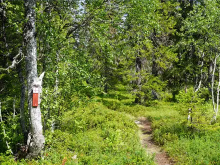
The GR1 is not technically hard: the high point is only 217 m and the walking is mostly on forest tracks, field paths, towpaths and lanes. The challenge is distance, with 540 km and 5,722 m of cumulative ascent spread across the loop. Winter can be muddy with short daylight. Navigation is generally helped by red-and-white GR waymarks, but suburban sections demand attention.
HikeList Score
GR1 (Île-de-France Circular Trail) scored 81/100 on HikeList's trail-quality metrics.
See score breakdownHide breakdown
- Ideal length 68
- Balanced challenge 100
- Scenery & wildness 66
- Varied terrain 94
- Accommodation 83
- Food & support 88
- Path quality 80
- Season flexibility 89
Computed from length, challenge, scenery & wildness, terrain variety, accommodation, food & support, path quality and season flexibility.
 France
Show more data Show less
- Lowland
- Forest
- Heathland
- River Valleys
- Agricultural Plains
- Dirt
- Gravel
- Paved
- Hotels
- Guesthouses
- GîTes
- Family Friendly
- Pet Friendly
- Restrooms
- Water Sources
- Campsites
- Picnic Areas
Photos from hikers
Taken on the trail by people who've reviewed GR1 (Île-de-France Circular Trail).
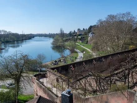
Departing from Saint-Germain-en-Laye, the trail winds through the tranquil Forest of Saint-Germain before descending to meet the Seine River. Passing small villages and riverside paths, you finish the day at the confluence of the Oise and Seine rivers in Conflans-Sainte-Honorine.
Follow the curves of the Oise, passing through the scenic Parc Naturel Régional du Vexin Français. The path traverses rural lands, mixed woodland, and peaceful streams until reaching the charming town of Méry-sur-Oise.
From Méry-sur-Oise, the trail meanders through lush riverbanks and passes small lakes, where birdlife abounds. Passing by woodlands, you arrive in L'Isle-Adam, renowned for its island park and riverside ambiance.
This day’s walk explores more of the Oise valley, flanked by traditional villages and scenic meadows. The forested sections provide welcome shade before entering the historical town of Beaumont-sur-Oise.
Leaving the Oise valley, the route heads southeast through rolling agricultural lands and a patchwork of small woodlands. Senlis, with its medieval streets and impressive Gothic cathedral, marks the day’s finish.
Today’s route leads south through the Forest of Ermenonville, a mosaic of pine, oak, and open heath. The final stretch circles serene ponds and ends at the village of Ermenonville, known for its romantic landscape gardens.
Through open countryside and past quiet fields, the trail reaches the Marne valley. Enter Meaux by following the river, arriving in a city famous for its historic center and renowned Brie cheese.
The path weaves alongside the Marne River, presenting rural panoramas and small farming hamlets. The day closes at La Ferté-sous-Jouarre, known for its riverside setting and millstone history.
Crossing more agricultural landscapes, you pass peaceful streams and occasional fruit orchards. This section ends in Coulommiers, a small town famed for its cheese and pleasant gardens.
The route navigates a variety of rural scenes, including poppy-filled fields and typical Île-de-France villages. The medieval city of Provins, with its fortifications and towers, concludes the day with a historical flourish.
Exiting Provins, the GR1 moves through the Seine-et-Marne countryside—open fields interspersed with forest patches and small, outlying villages. Reach Nangis, a modest market town, in the late afternoon.
Forest becomes the theme again as the route enters the legendary Fontainebleau Forest. Expect beautiful woodland paths and rock formations before reaching the iconic town of Fontainebleau.
Wind through more of Fontainebleau Forest, passing sandstone boulders and varied woodlands. Arrive at the picturesque town of Moret-sur-Loing, once beloved by impressionist artists.
Leaving Moret-sur-Loing, continue alongside the tranquil Loing River, with riverbank paths and forest stretches. End in Nemours, where a castle and museums await exploration.
Meander through sections of forest and agricultural fields, weaving between hamlets and tranquil countryside. Arrive in Milly-la-Forêt, noted for its local herb gardens and charming market square.
Vast open farmland and lines of trees accompany the path westward. The day concludes in Dourdan, where a medieval château and lively town center provide a welcoming end point.
Gentle hills and shallow valleys dominate this stage, crossing into Rambouillet Forest. Enter the town of Rambouillet, known for its picturesque château and vast parklands.
Wooded trails alternate with clearings before you exit the Rambouillet Forest. The medieval village of Montfort-l'Amaury sits amid hills and offers panoramic views and historic architecture.
Proceed through the gentle hills of the Chevreuse Valley, with paths that overlook peaceful streams and pass rustic stone farmhouses. Complete the day in the heart of the valley at Chevreuse.
Leave the rural heart of the valley and approach the outer suburbs of Paris. The route leads through wooded corridors and residential towns, finishing near the gardens of the world-famous Château de Versailles.
Navigate suburban greenways and public parks, including the Domaine de Sceaux. Today’s walk is a blend of wooded parkland, wide boulevards, and small towns.
Passing through southern edges of Paris, the GR1 makes use of urban parks, leafy streets, and wooded trails. The day’s highlight is the approach to the Château de Vincennes and the vast Parc Floral.
Travel northwards, alternating between city outliers and green suburban belts. This route segment offers glimpses of the urban-rural divide before reaching the village of Bouffémont.
The trail meanders through suburban parks, tranquil stretches of woodland, and minor rivers. Approaching Poissy, traces of the Seine reappear as you move toward the start of the loop.
The final segment of the GR1 leads along wooded paths and occasional riverside tracks. Finish your journey where you began, back in the vibrant suburb of Saint-Germain-en-Laye.
Reviews
How would you rate GR1 (Île-de-France Circular Trail)?
Tap a star to start your review — you could be the first.