Trans Swiss Trail (Route 2)
How would you rate Trans Swiss Trail (Route 2)?
Tap a star to share your experience and help other hikers.
Trans Swiss Trail (Route 2): Cross Switzerland on Foot
HikeList Score
Trans Swiss Trail (Route 2) scored 86/100 on HikeList's trail-quality metrics.
See score breakdownHide breakdown
- Ideal length 56
- Balanced challenge 100
- Scenery & wildness 88
- Varied terrain 100
- Accommodation 100
- Food & support 88
- Path quality 84
- Season flexibility 76
Computed from length, challenge, scenery & wildness, terrain variety, accommodation, food & support, path quality and season flexibility.
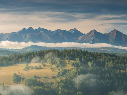
The Trans Swiss Trail is SwitzerlandMobility National Route 2: a 488 km, point-to-point thru-hike from Porrentruy in the Jura to Mendrisio in Ticino. It takes roughly 30 days to walk the full route, using 32 official stages, and is moderate overall: most walking is easy T1 terrain, but the Gotthard section adds altitude, snow-season constraints and longer mountain days. It suits hikers who want a continuous, waymarked crossing of Switzerland without technical alpine climbing.
Route Overview
Route 2 runs north to south across Switzerland, starting at Porrentruy near the French border and finishing at Mendrisio near Italy. The trail passes St-Ursanne, Biel/Bienne and the Three-Lakes region, then crosses the Bern region, Emmental and Entlebuch before reaching Lake Sarnen, Lake Lucerne and Flüelen. From there it follows the Reuss valley via Amsteg and Andermatt to the Gotthard Pass, descends the Tremola, continues along the Strada Alta above the Leventina, then reaches Biasca, Bellinzona, Tesserete, Lugano, Morcote and Mendrisio. It is a waymarked national route with luggage transport available; for a more alpine Swiss traverse compare the Alpine Pass Route, or for shorter Jura options see the Chasseral Ridge Walk.
History of the Trans Swiss Trail
The Trans Swiss Trail is National Route 2 in the SwitzerlandMobility / Wanderland network, one of seven official Swiss national hiking routes. Its historical character comes from old transport corridors woven into the route, especially around the Gotthard. The trail crosses the pass on the historic mule track, then descends by the Tremola, a cobbled pass road associated with centuries of goods movement and pack-animal travel before the rail and motorway tunnels changed Alpine transport.
Notable highlights
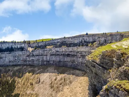
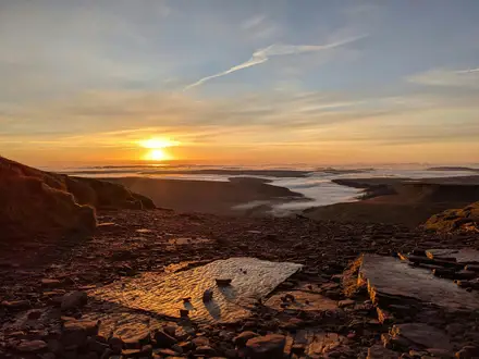
- Gotthard Pass and the Tremola (2,090 m): The highest point of the route is reached on foot by the historic cobbled mule path. Below the pass, the cobbled Tremola drops towards Airolo in 24 hairpins and is often called Switzerland’s longest road monument.
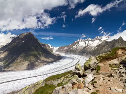
- Strada Alta Leventina: This high-level balcony trail in Ticino stays above the Leventina valley floor, giving broad views towards Val Bedretto while avoiding the main valley traffic below.
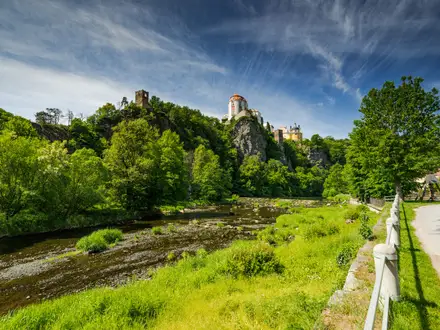
- St-Ursanne: An early Jura highlight, this medieval town on the Doubs has a Romanesque collegiate church and old gated walls, making it one of the route’s strongest cultural stops.
- Three-Lakes and Emmental: The middle section shifts to Seeland lake country and rolling Emmental farmland, a gentler contrast before the Gotthard and Ticino stages.
- Three Swiss cultures in one walk: The route crosses French-speaking Jura, German-speaking Central Switzerland and Italian-speaking Ticino in one continuous north–south journey. For a shorter Ticino panorama hike, see the Cardada Cimetta Panorama Trail.
Challenges to expect
The route is moderate rather than technical, but 488 km and about 17,600 m of ascent make it a serious long walk. Expect mixed surfaces: forest and meadow paths, farmland tracks, lakeside sections, and cobbled or paved mule routes on the Gotthard. The Alpine middle section is the main constraint; it is reliably snow-free only around July to October. Navigation is helped by green-and-yellow Route 2 markers, but accommodation should be booked ahead in summer.
HikeList Score
Trans Swiss Trail (Route 2) scored 86/100 on HikeList's trail-quality metrics.
See score breakdownHide breakdown
- Ideal length 56
- Balanced challenge 100
- Scenery & wildness 88
- Varied terrain 100
- Accommodation 100
- Food & support 88
- Path quality 84
- Season flexibility 76
Computed from length, challenge, scenery & wildness, terrain variety, accommodation, food & support, path quality and season flexibility.
Show more data Show less
- Forest
- Farmland
- Lakeside
- Mountainous
- Dirt
- Gravel
- Cobbled
- Paved
- Hotels
- Guesthouses
- Hostels
- Huts
- Family Friendly
- Pet Friendly
- Restrooms
- Water Sources
- Campsites
- Shelters
- Picnic Areas
Download Our Full Guide to Trans Swiss Trail (Route 2) FREE!
Get our comprehensive guide to this hike for free. Save it for later reading or print out at home.
In these collections
Photos from hikers
Taken on the trail by people who've reviewed Trans Swiss Trail (Route 2).
Trans Swiss Trail (Route 2): The Complete Guide
 i
Image by Lunadine
i
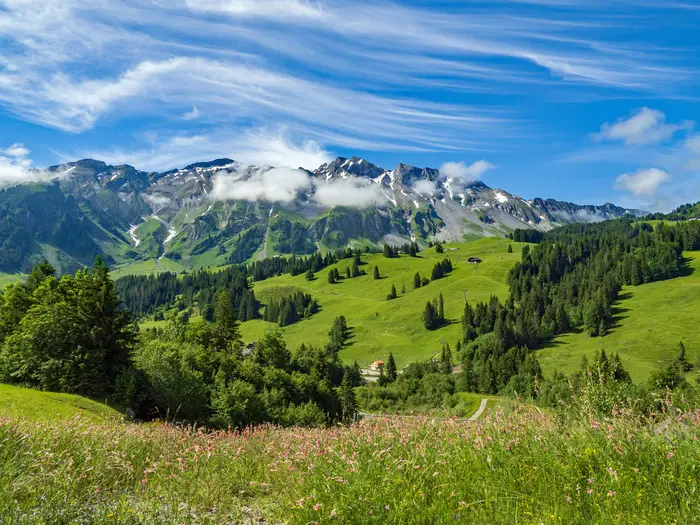
Image by Lunadine The Trans Swiss Trail is a rare kind of long-distance walk: a full north-to-south crossing of Switzerland that stays mostly on approachable, waymarked hiking paths. It runs from Porrentruy in the Jura to Mendrisio in Italian-speaking Ticino, passing through French-, German- and Italian-speaking Switzerland without needing technical alpine climbing.
Its appeal is the scale of the transition. The route moves from limestone hills and the Doubs valley to the Three-Lakes region, Bern, Emmental and Entlebuch farmland, then into the Reuss valley and the Gotthard before dropping onto the Strada Alta and the southern lakes and hills of Ticino.
This is a strong choice for fit walkers who want a first major thru-hike with excellent public transport, clear SwitzerlandMobility signing and regular towns along the way. It also suits experienced hikers who value a continuous journey more than high technical difficulty.
The walk still asks for commitment. At 488 km with about 17,600 m of ascent, the challenge is endurance, daily logistics and timing the Gotthard section for the usual July-to-October snow-free window.
This guide covers stages, itinerary length, accommodation, food, transport, terrain and the common planning mistakes that matter on Route 2.
Stage-by-Stage Guide
Stage distances below are approximate planning distances. Check the current SwitzerlandMobility Route 2 stage page before booking accommodation or relying on a transport connection, especially in the Gotthard and upper Leventina sections where snow and seasonal opening times matter.
Stage 1: Porrentruy to St-Ursanne — approx. 18 km
This opening stage leaves Porrentruy in the Jura and works towards St-Ursanne, one of the strongest cultural stops on the whole trail. Expect Jura countryside rather than alpine terrain: manageable paths and tracks, with the route already feeling rural soon after the rail-served start town.
St-Ursanne sits on the River Doubs and is a good place to stop rather than rush through, with its medieval walls, stone bridge and Romanesque-Gothic collegiate church. It also makes a practical first overnight because the town is a recognised route stage end.
Carry enough food and water for the day, even though both Porrentruy and St-Ursanne are proper settlements. Accommodation and onward public transport at St-Ursanne should be checked before travelling, particularly outside the main walking season.
Navigation should be straightforward on the green-and-white Route 2 waymarking, but take care leaving Porrentruy and entering St-Ursanne where urban junctions can be less obvious than open-country signs.
Stage 2: St-Ursanne to Soubey — approx. 17 km
This is the Doubs valley stage, linking St-Ursanne with the smaller riverside settlement of Soubey. The walking is still Jura in character: wooded slopes, valley paths and quieter rural ground rather than high mountains.
The River Doubs is the main landmark and gives the stage a different feel from the plateau walking that follows. Paths are generally non-technical, but valley routes can be damp or muddy after rain, so footwear with decent grip is useful.
Soubey is a smaller stage end than St-Ursanne. Do not assume full shops or late-opening food options: carry lunch and confirm evening meal, accommodation and any public-transport connection before setting off.
Waymarking is the main navigational aid. In wooded sections, keep an eye on Route 2 signs at junctions and do not rely solely on following the river.
Stage 3: Soubey to Saignelégier — approx. 16 km
This stage climbs away from the Doubs valley towards Saignelégier and the Franches-Montagnes. It is a short-to-moderate day by route standards, but the change from river valley to high Jura plateau makes it feel like a distinct transition.
The Franches-Montagnes are known for open pasture, spruce woods and Freiberger horses. Expect a mix of meadow, forest and farm-track walking, with more exposed plateau weather than the sheltered Doubs valley.
Saignelégier is a useful overnight halt in the Jura. Food, water and accommodation should still be planned in advance, as rural Swiss villages do not always have long shop or restaurant hours.
Navigation is usually uncomplicated, but pasture and forest junctions require attention. Respect livestock and keep to the marked line where the trail crosses working farmland.
Stage 4: Saignelégier to St-Imier — approx. 18 km
The route continues across the Jura from Saignelégier to St-Imier, with more open upland pasture and woodland. The terrain remains non-technical but can feel broad and exposed in poor weather.
This is a day for steady progress rather than difficult walking. The Franches-Montagnes landscape gradually gives way towards the St-Imier side, with farm tracks and paths forming much of the underfoot character.
St-Imier is the key planning anchor at the end of the stage. Check accommodation and public transport before travelling; the Swiss network is strong, but the exact timing of onward connections matters if section-walking.
Carry food and water from Saignelégier unless current services along the day have been checked. Waymarking should be reliable, but mist or low cloud on higher Jura ground can make careful map use worthwhile.
Stage 5: St-Imier to Chézard-St-Martin — approx. 18 km
This stage continues the west-to-east progression through the Jura towards the Val-de-Ruz area. It is still largely moderate walking on paths, tracks and rural lanes, with no technical alpine obstacles.
The main interest is the gradual approach towards Neuchâtel country. The route remains a working landscape of villages, farmland and wooded slopes rather than a remote mountain stage.
Chézard-St-Martin is the end point and should be treated as a practical village halt. Confirm accommodation, evening food and any bus or rail link before depending on them.
Navigation is generally by Route 2 waymarks. Pay attention at village exits and road crossings, where the route may turn sharply between tracks and minor roads.
Stage 6: Chézard-St-Martin to Neuchâtel — approx. 15 km
This shorter stage brings the trail down towards Neuchâtel and the Three-Lakes region. After the quieter Jura stages, the finish in Neuchâtel gives access to a larger lakeside town and a more extensive choice of services.
Expect a mix of rural approaches and more urban walking nearer Neuchâtel. The path conditions remain easy by mountain standards, but hard surfaces may increase as the route enters the town.
Neuchâtel is one of the most useful resupply and rest points on the northern half of the trail. Accommodation, food and public transport are far easier here than in smaller Jura stage ends.
Navigation becomes more town-based at the end of the day. Follow Route 2 signs carefully through built-up areas rather than assuming the most direct line to the lakefront or station.
Stage 7: Neuchâtel to Murten/Morat — approx. 19 km
This stage crosses into the Three-Lakes landscape, with gentler lake-country walking replacing the Jura hills. The terrain is generally easier underfoot, with lakeside ways, farmland and flatter sections typical of Seeland.
The contrast with the previous stages is the main highlight: water, vineyards and open farmland replace the wooded Jura. Murten/Morat, with its bilingual name, marks the cultural transition that continues across the middle of Switzerland.
Food and water are easier to plan from Neuchâtel, but carry enough for the whole day unless intermediate services have been checked. Murten/Morat should offer more stage-end options than the smallest rural stops, but booking remains sensible in summer.
Navigation can be deceptively tricky in flatter lake country because there are more tracks, roads and settlement edges. Keep following the red Route 2 number at junctions.
Stage 8: Murten/Morat to Laupen — approx. 14 km
This is one of the shorter official stages and is a useful lower-effort day between the Three-Lakes region and the Bern approach. The walking is mostly lowland and rural, with easy terrain rather than steep climbing.
Laupen is the principal end point and a logical halt before the stage into Bern. The day is suitable for combining with nearby stages only if accommodation and transport plans still work; do not underestimate cumulative fatigue over a 488 km crossing.
Carry normal day food and water from Murten/Morat. Laupen’s current accommodation and meal options should be checked before travelling, as the stage end is smaller than Bern.
Waymarking should be straightforward, but lowland farmland often has frequent path and track junctions. Watch for Route 2 signs where the trail changes direction between fields, lanes and village edges.
Stage 9: Laupen to Bern — approx. 16 km
This stage brings the route into Bern, the Swiss capital and a major logistical break point. The terrain remains moderate, with the finish becoming increasingly urban as the trail reaches the Aare loop and the old city.
Bern’s UNESCO-listed Old Town is the obvious highlight, with arcaded sandstone streets and the clock tower forming a major contrast to the rural stages before it. It is also one of the best places on the trail for a rest night, laundry, repairs and resupply.
Food and water are easy to arrange at the Bern end, but start from Laupen with enough for the walking day. Accommodation in Bern is plentiful by trail standards but should still be booked ahead in busy periods.
Navigation through the outskirts and old town needs attention because urban waymarks can be missed among street furniture and crossings. Use the Route 2 signs together with a map app or the SwitzerlandMobility map.
Stage 10: Bern to Worb — approx. 16 km
Leaving Bern, the trail moves from city walking back into the countryside east of the capital. This is a moderate day and a useful reset after the urban mid-route stop.
The route begins the transition towards Emmental landscapes: rolling farmland, villages and gentler hills. Underfoot, expect a mix of paved sections near Bern, farm tracks and paths.
Worb is the stage end and should be checked for accommodation and food before relying on it. Public-transport access in the Bern region is generally strong, making this a practical section-walking stage.
The main navigational issue is leaving the city correctly and staying with Route 2 through the suburban-to-rural transition. After rain, farm paths may be muddy.
Stage 11: Worb to Lützelflüh — approx. 17 km
This stage continues into the Emmental, one of the classic rural sections of the Trans Swiss Trail. The walking is still non-technical but more rolling than the flatter lake-country days.
Expect dairy farmland, wooded patches and village-to-village walking. The landscape is open enough for wide views in clear weather, though the route remains a countryside walk rather than a mountain traverse.
Lützelflüh is the stage end. Confirm overnight options and evening meals in advance, especially if arriving late or walking outside the main summer period.
Carry food and water from Worb unless known services have been checked along the way. Keep to marked paths across farmland and be considerate around livestock, gates and farmyards.
Stage 12: Lützelflüh to Langnau im Emmental — approx. 16 km
This is another Emmental stage, linking two route settlements through rolling green countryside. The terrain is moderate, with repeated small rises and descents more significant than any single technical obstacle.
Langnau im Emmental is a useful larger stop within the Emmental section. It is a sensible place to restock before the route becomes more rural again towards Eggiwil, Schangnau and Entlebuch.
Food and water should be carried for the day, with services at the end checked before departure. Accommodation in Langnau im Emmental should be booked ahead during holiday periods.
Navigation is generally easy on waymarked rural paths and tracks, but there may be frequent junctions around farms and villages. Mud is possible on pasture paths after wet weather.
Stage 13: Langnau im Emmental to Eggiwil — approx. 14 km
This shorter stage continues through Emmental countryside towards Eggiwil. The distance is modest, but the walking still includes rolling farmland rather than flat valley progress.
The stage is a good opportunity to manage energy before the more demanding rural and pre-alpine days that follow. Expect quiet paths, farm tracks and country lanes.
Eggiwil is smaller than Langnau im Emmental, so do not arrive without a plan for the night. Check accommodation, dinner options and onward transport before travelling.
Carry enough food and water for the day. Navigation should be uncomplicated, but farmland waymarking needs attention at gates, track junctions and village exits.
Stage 14: Eggiwil to Schangnau — approx. 15 km
This stage is one of the more demanding rural days before the mountains proper. The route moves deeper into the Emmental and towards Entlebuch, with hillier terrain and a more remote feel than the Bern-side stages.
Paths and tracks remain non-technical, but the day can feel harder than its distance suggests because of the rolling ground. Wet grass, mud and farm tracks can slow progress after rain.
Schangnau is a small stage end, so accommodation and food should be arranged in advance. This is not a stage to finish late while hoping to find multiple options on arrival.
Carry full day supplies from Eggiwil. Route 2 signs should be followed carefully across rural junctions, and walkers should be prepared for fewer services between settlements.
Stage 15: Schangnau to Sörenberg — approx. 15 km
This stage enters the Entlebuch side of the route and begins to feel more pre-alpine. The walking remains within the moderate, non-technical character of Route 2, but the landscape becomes wilder and more enclosed by higher ground.
Sörenberg is the key end point and a useful base in the UNESCO Entlebuch Biosphere area. The area is thinner for accommodation than the larger lowland towns, so summer booking is strongly advised.
Carry food and water from Schangnau unless current services are known. Mountain weather begins to matter more from here: start with waterproofs, warm layers and enough daylight for delays.
Navigation should be clear on the waymarked route, but cloud and rain can reduce visibility on higher open ground. Check local conditions before setting off.
Stage 16: Sörenberg to Giswil — approx. 17 km
This is a transition stage from Entlebuch towards the Lake Lucerne hinterland and central Switzerland. It is a more serious walking day than the lowland stages, with mountain weather and elevation changes becoming more relevant.
The terrain is still hiking-path terrain rather than alpine climbing, but expect a mix of forest, meadow and steeper ground. Conditions can change quickly in poor weather, and early-season snow patches are possible in the wider alpine section.
Giswil is the stage end and should provide a stronger valley base than the smaller upland stops, but accommodation and transport should still be checked before travelling. Use this stage end to reassess weather before continuing towards Flüeli-Ranft, Stans and Seelisberg.
Carry enough food and water for the day. Navigation needs more care than on the easier lake-country stages, especially in forest and where the trail changes between paths, tracks and minor roads.
Stage 17: Giswil to Flüeli-Ranft — approx. 15 km
This stage links Giswil with Flüeli-Ranft, the hillside pilgrimage hamlet associated with Niklaus von Flüe, known as Brother Klaus. The route sits in central Swiss countryside with more vertical relief than the early lowland stages.
The Melchaa gorge setting gives the finish particular character. Paths are generally suitable for normal hiking, though steeper or damp sections around gorges and wooded slopes deserve care.
Flüeli-Ranft is a distinctive overnight stop but not a large town. Book accommodation ahead and check evening food before relying on arrival services.
Carry day supplies from Giswil. Navigation should follow Route 2 signs, with extra attention near the gorge, hamlet approaches and any road crossings.
Stage 18: Flüeli-Ranft to Stans — approx. 17 km
The route continues through the Lake Lucerne hinterland towards Stans. This is a moderate central-Swiss stage with a mix of paths, tracks, village walking and valley approaches.
Stans is a practical stage end and a good place to regroup before the longer Lake Lucerne and Uri stages that follow. The terrain is varied but not technically difficult in normal conditions.
Food, water and accommodation are easier to organise at Stans than at smaller hamlets, but summer bookings remain sensible. Public-transport access is useful here for section walkers.
Navigation becomes more settlement-based as the route approaches Stans. Follow the Route 2 signs carefully through built-up areas and across road junctions.
Stage 19: Stans to Seelisberg — approx. 20 km
This is a longer and more scenic central-Swiss stage, moving towards Lake Lucerne and Seelisberg. Expect a fuller day with woodland, lake-side or lake-influenced walking, and more ascent and descent than the easiest lowland stages.
The Lake Lucerne views are the main reward, with the Seelisberg area giving balcony-like perspectives over the water. The Risleten gorge and waterfall are among the notable features in this part of the route.
Carry enough food and water for a 20 km day. Seelisberg accommodation should be booked ahead, particularly in summer and at weekends.
Public transport and road access in this region are generally good, but exact connections should be checked before travelling. Navigation requires attention around wooded sections, lake approaches and village junctions.
Stage 20: Seelisberg to Erstfeld — approx. 24 km
At roughly 24 km, this is one of the longest stages on the route and should be treated as a serious day. It continues through the Lake Lucerne and Uri transition towards Erstfeld, where the trail approaches the Reuss valley and the Gotthard corridor.
The distance is the main challenge, not technical climbing. Allow enough time for steady progress, breaks and any slower sections through forest or along valley routes.
Erstfeld is an important logistical stop before the route heads to Wassen, Andermatt and the Gotthard. Accommodation and transport should be checked and booked ahead if possible.
Start with full food and water unless specific services along the day have been checked. Because of the long distance, an early start is sensible; poor weather or tiredness can make this stage feel much longer than the map suggests.
Stage 21: Erstfeld to Wassen — approx. 19 km
This stage follows the route south through the Uri/Reuss valley towards Wassen. The walking is still waymarked and non-technical, but it sits in a more alpine transport corridor, with the Gotthard section now close ahead.
Expect a mixture of valley paths, tracks and settlement links rather than remote high-mountain walking. The surrounding terrain becomes steeper and more dramatic as the route nears Andermatt.
Wassen is the stage end and a key overnight before the climb to Andermatt. Book accommodation and check food options in advance, as flexibility becomes more limited in the alpine middle section.
Carry food and water from Erstfeld. Navigation should be straightforward, but be attentive around roads, bridges and built-up sections in the valley.
Stage 22: Wassen to Andermatt — approx. 10 km
This is a short but important mountain-approach stage, climbing towards Andermatt through the Schöllenen gorge area. The Teufelsbrücke, or Devil’s Bridge, is the major landmark and one of the dramatic moments before the Gotthard Pass.
Although the distance is only about 10 km, the terrain is more rugged in feel than the lowland stages. Paths and historic routes through gorge terrain can be steep, confined or slippery in wet weather.
Andermatt is the key base before the Gotthard crossing. It is one of the most important places on the whole trail for checking weather, pass conditions, snow cover and accommodation on or beyond the pass.
Carry normal day supplies from Wassen, even for the shorter distance. Navigation through gorge infrastructure and road-adjacent areas requires care: follow Route 2 signs and avoid improvising near traffic or steep ground.
Stage 23: Andermatt to Gotthard Pass / Passo del San Gottardo — approx. 13 km
This is the ascent to the high point of the Trans Swiss Trail, reaching the Gotthard Pass / Passo del San Gottardo at about 2,090 m. The route uses the historic cobbled mule path, making it one of the most memorable and physically significant stages of the crossing.
The distance is moderate, but the altitude and ascent make it a mountain day. Snow-free conditions are most reliable from roughly July to October, and pass conditions should be checked before travelling.
Food, water and accommodation on or near the pass are more seasonal than in valley towns. Book ahead and carry enough supplies to be self-sufficient for the day if services are closed or limited.
Navigation is generally aided by the clear historic line and Route 2 waymarks, but weather can change quickly around the pass. Do not start in poor visibility or uncertain snow conditions without appropriate mountain judgement.
Stage 24: Gotthard Pass / Passo del San Gottardo to Airolo — approx. 13 km
This stage crosses from the pass into Italian-speaking Ticino and descends towards Airolo. The defining feature is the Tremola, the cobbled old Gotthard pass road with its long sequence of hairpins dropping south.
The descent is not technically difficult in normal summer conditions, but cobbles can be hard on feet and slippery when wet. Trekking poles can help reduce strain on knees during the sustained descent.
Airolo is the first major Ticino stage end after the pass and a practical place to recover, resupply and reassess the next high-level Leventina stages. Accommodation and transport should be checked before travelling.
Carry food and water from the pass unless services are certain. Navigation is usually clear, but take care where the walking route interacts with historic road sections and any modern road crossings.
Stage 25: Airolo to Osco — approx. 16 km
From Airolo the route enters the Leventina and begins the Strada Alta section, staying above the valley floor. This is a high-level balcony stage, with views over the valley while avoiding the traffic and railway below.
The terrain is mainly mountain-side village and path walking rather than a high pass, but it remains more committing than the easy lowland sections. Expect traversing paths, forest, open slopes and rural lanes.
Osco is a smaller stage end, so accommodation and evening food should be booked before arrival. Do not assume a wide choice of services in the high Leventina villages.
Carry food and water from Airolo. Navigation on balcony routes requires attention where paths enter villages, cross lanes or turn through woodland.
Stage 26: Osco to Anzonico — approx. 14 km
This stage continues along the Strada Alta Leventina, maintaining the high-level character above the valley. The walking is moderate in distance but can feel slow if the path repeatedly rises and falls along the hillside.
Views across and down the Leventina are the main highlight. The route’s appeal here is staying on the quieter slopes while the main valley corridor lies below.
Anzonico is a small stage end and needs advance planning. Confirm accommodation, dinner and onward transport before committing to the day.
Carry sufficient food and water from Osco, as services between balcony villages may be limited or irregular. Waymarking should be followed carefully through village lanes and wooded sections.
Stage 27: Anzonico to Biasca — approx. 17 km
This stage leaves the higher Leventina balcony and works towards Biasca. It marks a gradual return from upland village terrain towards a larger valley town.
The walking remains varied, with paths, tracks and settlement approaches. Descending stages can be tiring, especially after the Gotthard and Strada Alta days, so allow time and avoid rushing.
Biasca is an important resupply and transport stop before the route continues to Bellinzona. Accommodation and food options should be easier than in the smaller balcony villages, but booking remains sensible.
Carry food and water for the day from Anzonico. Navigation may become busier near Biasca as the route approaches roads, buildings and valley infrastructure.
Stage 28: Biasca to Bellinzona — approx. 20 km
This stage follows the Ticino valley towards Bellinzona, one of the major cultural and logistical highlights near the southern end of the trail. At around 20 km, it is a substantial but generally lower-level day.
Bellinzona sits near the route’s lowest point and is known for its three medieval castles: Castelgrande, Montebello and Sasso Corbaro. It is an excellent place for an overnight stop, resupply or rest day.
Carry normal day supplies from Biasca, but services at Bellinzona are much stronger than in the upper Leventina villages. Accommodation should still be booked ahead in busy periods.
Navigation into Bellinzona is more urban and valley-based. Follow Route 2 signs closely through road crossings, suburbs and town streets.
Stage 29: Bellinzona to Tesserete — approx. 22 km
This is a long southern Ticino stage from Bellinzona towards Tesserete. The route leaves the major valley town and returns to hill country before the Lugano area.
The distance makes this a serious day, even though the route remains non-technical. Expect a mixture of tracks, paths, village links and southern Swiss hill terrain.
Tesserete is the stage end and should be booked in advance if staying there. Check food and transport before travelling, particularly if walking late in the season or planning to connect onward the same day.
Start with enough food and water for a full 22 km stage. Navigation can require care where the trail passes through villages and changes between rural paths and minor roads.
Stage 30: Tesserete to Lugano (Comano) — approx. 13 km
This shorter stage brings the trail into the Lugano area, ending at Lugano (Comano). After the longer Bellinzona to Tesserete day, it can work well as a lighter walking day or as part of a flexible Lugano-based plan.
The terrain is southern Ticino hill and settlement-edge walking rather than remote country. Expect more built-up sections as the route approaches Lugano.
Lugano is one of the most useful service centres on the southern part of the trail, with strong accommodation, food and transport options. If staying in central Lugano rather than Comano, local connections should be checked before travelling.
Carry water and snacks from Tesserete, but resupply at the Lugano end should be straightforward. Urban navigation needs attention: Route 2 signs can be easy to miss among roads and neighbourhood junctions.
Stage 31: Lugano (Paradiso) to Morcote — approx. 16 km
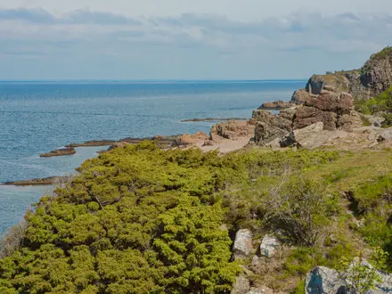
This stage starts from Lugano (Paradiso), so check the connection between the previous stage’s Lugano (Comano) finish, accommodation and the Paradiso start point. It then continues through the Lake Lugano landscape towards Morcote.
The walking combines southern lake-and-hill terrain with more settlement influence than the alpine middle of the trail. Morcote, with its lakeside terraces, is the main highlight and one of the most attractive final-stage stops.
Food and water are easier to arrange around Lugano, but carry enough for the full stage once away from the city. Accommodation in Morcote should be booked ahead, especially in the main summer and autumn walking season.
Navigation leaving Lugano/Paradiso requires care because the route passes through a busy urban and lake-edge environment before becoming more trail-like. Follow Route 2 waymarks closely and check the exact stage start before setting off.
Stage 32: Morcote to Mendrisio — approx. 17 km
The final stage leaves Lake Lugano country and heads to Mendrisio in the Mendrisiotto, close to the Italian border. It is a fitting finish through the southern Ticino hills, with the route remaining a waymarked hiking line rather than a technical mountain route.
Mendrisio is the official end of the current Route 2 and has its own railway station on the Bellinzona–Lugano–Chiasso line. This makes onward travel straightforward compared with many long-distance trail termini, though train times should still be checked before travelling.
Carry food and water from Morcote, particularly if planning to go directly onward after finishing. Mendrisio offers the best end-of-route logistics: accommodation, food and rail access are all more practical than at a small village finish.
Navigation matters until the final waymarks are reached; do not relax too early on road crossings, village junctions or urban approaches. In warm weather, the southern Ticino stages can feel hotter than the Gotthard or central-Swiss sections, so start with enough water.
Recommended Itinerary
The cleanest end-to-end plan is to follow the 32 official SwitzerlandMobility stages from Porrentruy to Mendrisio. Most days sit in the 14–20 km range, with a few longer days and a deliberately shorter approach into the Gotthard section.
Distances below use the route stage figures and should be treated as planning distances, not booking guarantees. Check official mapping before booking accommodation, especially where a stage end is a small village or where public transport is needed to shorten a day.
Standard 32-day itinerary
| Day | From | To | Approx. distance | Why this stage makes sense | Services/accommodation notes |
|---|---|---|---|---|---|
| 1 | Porrentruy | St-Ursanne | 18 km | A manageable first day from the official start into the Doubs valley, ending in one of the route’s strongest early cultural stops. | Porrentruy has a railway station. St-Ursanne is a natural overnight stop; book ahead in busy periods. |
| 2 | St-Ursanne | Soubey | 17 km | Keeps the Jura opening steady without overloading the first week. | Soubey is a smaller village stop; carry food for the day and arrange accommodation before setting off. |
| 3 | Soubey | Saignelégier | 16 km | A moderate day onto the Franches-Montagnes plateau. | Saignelégier is a practical Jura overnight; check accommodation availability before relying on a same-day booking. |
| 4 | Saignelégier | St-Imier | 18 km | Continues across the Jura in a full but not excessive day. | St-Imier is a sensible stage town before the route bends towards the Three-Lakes region. |
| 5 | St-Imier | Chézard-St-Martin | 18 km | Keeps daily distance consistent while moving out of the higher Jura. | Chézard-St-Martin is a smaller stage end; book ahead rather than assuming multiple options. |
| 6 | Chézard-St-Martin | Neuchâtel | 15 km | A shorter day into a major lakeside town, useful for laundry, resupply and an easier afternoon. | Neuchâtel is one of the route’s major public-transport and accommodation stops. |
| 7 | Neuchâtel | Murten/Morat | 19 km | A full but straightforward day through the Three-Lakes country. | Murten/Morat is a good overnight in the lake region; summer accommodation should be booked in advance. |
| 8 | Murten/Morat | Laupen | 14 km | A shorter transition day before reaching Bern, useful if the first week has been tiring. | Laupen is a smaller stop; confirm accommodation before committing to the stage. |
| 9 | Laupen | Bern | 16 km | A moderate day into the Swiss capital, making Bern the obvious logistics reset. | Bern has extensive accommodation, resupply and rail connections. It is the best early rest-day candidate. |
| 10 | Bern | Worb | 16 km | Eases out of the city without making the first post-Bern day too long. | Worb is close enough to the Bern region for flexible planning, but accommodation should still be checked before travelling. |
| 11 | Worb | Lützelflüh | 17 km | A steady day into Emmental countryside. | Lützelflüh is a village-stage overnight; reserve ahead, especially at weekends or in high season. |
| 12 | Lützelflüh | Langnau im Emmental | 16 km | Keeps the Emmental section comfortably paced. | Langnau im Emmental is a useful overnight and resupply point before smaller rural stages. |
| 13 | Langnau im Emmental | Eggiwil | 14 km | A shorter day before the more demanding rural stretch towards Entlebuch. | Eggiwil is a smaller stop; book accommodation and do not rely on late availability. |
| 14 | Eggiwil | Schangnau | 15 km | Short on paper, but placed well in a harder part of the route where climbing and rural logistics matter more than distance. | Schangnau is a small village stage end; accommodation should be secured in advance. |
| 15 | Schangnau | Sörenberg | 15 km | A controlled day into the Entlebuch and towards the Alpine middle of the trail. | Sörenberg is in the thinner, more seasonal accommodation belt; summer nights should be booked ahead. |
| 16 | Sörenberg | Giswil | 17 km | A solid mountain-country day that keeps the approach to Central Switzerland measured. | Giswil is a practical valley overnight; confirm current transport and accommodation before booking linked onward stages. |
| 17 | Giswil | Flüeli-Ranft | 15 km | A shorter day ending at the pilgrimage hamlet above the Melchaa gorge. | Flüeli-Ranft is a distinctive but small overnight stop; book before arrival. |
| 18 | Flüeli-Ranft | Stans | 17 km | Returns to a more substantial Central Swiss stage town before the Lake Lucerne section. | Stans is a useful place to reset before the longer lake-and-valley days that follow. |
| 19 | Stans | Seelisberg | 20 km | A longer day, but worth keeping intact for the Lake Lucerne and Seelisberg balcony section. | Seelisberg accommodation can be seasonal; reserve ahead and check onward transport options if shortening the day. |
| 20 | Seelisberg | Erstfeld | 24 km | One of the longest standard stages, moving decisively into the Reuss valley and towards the Gotthard approach. | Erstfeld is one of the route’s rail-linked hubs. Consider shortening this day by public transport if 24 km is too much. |
| 21 | Erstfeld | Wassen | 19 km | A full approach day up the valley before the shorter climb to Andermatt. | Wassen is an Alpine approach stop; book ahead, particularly in summer. |
| 22 | Wassen | Andermatt | 10 km | Short by design, leaving time and energy before the Gotthard high point. | Andermatt is a major mountain transport and accommodation hub. It is the best place to pause before the pass. |
| 23 | Andermatt | Gotthard Pass / Passo del San Gottardo | 13 km | The key ascent of the route, using the historic cobbled mule path to reach the high point at about 2,090 m. | This is the most season-sensitive overnight. Check pass conditions and book ahead; the Gotthard section is generally a July–October proposition. |
| 24 | Gotthard Pass / Passo del San Gottardo | Airolo | 13 km | A short but important descent day over the watershed and down the Tremola towards Ticino. | Airolo is a rail-linked valley town and a practical recovery stop after the pass. |
| 25 | Airolo | Osco | 16 km | Begins the Strada Alta Leventina section at a sensible distance. | Osco is a small high-level village stop; accommodation should be arranged in advance. |
| 26 | Osco | Anzonico | 14 km | Keeps the high balcony walking short enough to enjoy without rushing. | Anzonico is another small Strada Alta overnight; book ahead and carry enough food for the day. |
| 27 | Anzonico | Biasca | 17 km | Drops from the high-level Leventina section to a more substantial valley town. | Biasca is one of the route’s main transport hubs and a good resupply/reset point. |
| 28 | Biasca | Bellinzona | 20 km | A full valley day to Ticino’s castle city and the route’s lowest area. | Bellinzona has extensive rail connections and accommodation. It is an excellent rest-day or late-trip logistics stop. |
| 29 | Bellinzona | Tesserete | 22 km | A long southern-Ticino stage that moves the route towards the Lugano hills. | Tesserete is a smaller stage end after a long day; book accommodation before leaving Bellinzona. |
| 30 | Tesserete | Lugano (Comano) | 13 km | A shorter day into the Lugano area, useful after the longer Bellinzona–Tesserete stage. | The Lugano-area staging needs care: this stage ends at Lugano (Comano), while the next starts at Lugano (Paradiso). Check official mapping before booking. |
| 31 | Lugano (Paradiso) | Morcote | 16 km | A manageable lake-and-hill day through the southern finish country. | Morcote is a popular lakeside overnight; book ahead in the main walking season. |
| 32 | Morcote | Mendrisio | 17 km | A final full but moderate stage to the official finish in Mendrisio. | Mendrisio has its own railway station on the Bellinzona–Lugano–Chiasso line for onward travel. |
Slower variant: 34–38 days
A slower schedule suits first-time thru-hikers, walkers carrying heavier packs, or anyone who wants a buffer for weather around the Gotthard. Add rest or half-rest days at practical service points such as Neuchâtel, Bern, Andermatt, Airolo, Bellinzona or Lugano.
The most sensible days to soften are the longer or more seasonal ones: Stans–Seelisberg, Seelisberg–Erstfeld, Bellinzona–Tesserete, and the Gotthard approach/descent. Switzerland’s public-transport network makes it realistic to shorten a stage without abandoning the overall line, but accommodation and transport timings should be checked before travelling.
Faster variant: 28–30 walking days
A faster itinerary is realistic for strong walkers with light packs who are comfortable with occasional 25–30 km days. The best places to save time are the lower, better-served sections rather than the Gotthard or the thinner Strada Alta Leventina villages.
Possible combinations include Murten/Morat to Bern via Laupen at about 30 km, or Langnau im Emmental to Schangnau via Eggiwil at about 29 km. Wassen to the Gotthard Pass / Passo del San Gottardo via Andermatt is about 23 km but includes the Alpine crux and should only be considered in settled conditions with suitable fitness and accommodation already arranged.
For most independent hikers, the standard 32-stage plan is the safest booking framework. It keeps the route’s logistics simple, gives the Gotthard the time it deserves, and still leaves public-transport flexibility if a day needs to be shortened.
Planning the Route
The Trans Swiss Trail is easiest to plan around the 32 SwitzerlandMobility stages, but it does not have to be walked exactly that way. Most fit walkers should allow roughly 28–32 walking days, depending on how often stages are combined, shortened by public transport or split with rest days.
Do not plan it like a remote wilderness route. The practical challenge is not isolation; it is managing a long sequence of bookings, transport links, changing language regions and the mountain weather window around the Gotthard Pass / Passo del San Gottardo.
How many days to allow
The official stage pattern is a sensible default because most stages finish in towns or villages with onward transport. Daily distances are generally moderate, but the cumulative distance and ascent make a compressed schedule tiring, particularly before and after the Gotthard.
A faster end-to-end schedule is possible by combining shorter days, especially where the terrain is gentle and transport is dense. A slower schedule is often more enjoyable, with time built in for Bern, Lake Lucerne, Bellinzona, Lugano or for waiting out poor mountain weather.
| Itinerary style | Typical plan | Best suited to |
|---|---|---|
| Official-stage pace | 32 walking days | Most end-to-end walkers who want a steady, low-risk schedule |
| Moderately compressed | About 28–30 walking days | Fit walkers comfortable with occasional longer days or transport shortcuts |
| Slower / flexible | 33+ days | Walkers adding rest days, sightseeing, weather buffers or shorter mountain stages |
The two shortest official stages in the Gotthard section, Wassen–Andermatt and Andermatt–Gotthard Pass / Passo del San Gottardo, should not automatically be dismissed as “easy days”. They sit in the higher mountain part of the route, where weather, snow conditions and ascent matter more than distance alone.
Using the official stages
The official 32-stage structure is the best planning framework for a first itinerary. It links a logical chain of overnight stops from Porrentruy through St-Ursanne, Neuchâtel, Bern, Langnau im Emmental, Sörenberg, Stans, Andermatt, Airolo, Biasca, Bellinzona, Lugano and Mendrisio.
Stage ends are generally practical rather than arbitrary: they tend to fall at settlements with accommodation and public transport nearby. That said, the supply of beds is not equally strong everywhere. Valley towns and cities give the most choice; the Entlebuch, Lake Lucerne hinterland, Gotthard and upper Leventina sections need more careful booking.
Before fixing the itinerary, check each stage on SwitzerlandMobility for current stage distance, ascent and route notes. The published per-stage distances are close enough for broad planning, but exact day planning should use the current official route map.
Where to build in flexibility
The Gotthard is the main place to leave spare time. The route climbs from Andermatt to the Gotthard Pass / Passo del San Gottardo at about 2,090 m, then descends towards Airolo by the historic Tremola hairpins. This is the scenic and physical crux of the walk, and it has a much narrower reliable season than the lower country.
Plan the high section for roughly July to October and check pass conditions before committing to it. Early-summer snow, autumn storms or poor visibility can all make the pass less straightforward than the route’s generally easy technical grade suggests.
A useful buffer is to avoid making non-changeable onward travel arrangements immediately after the Gotthard days. Andermatt, Airolo and the larger Ticino valley towns give more scope to pause, re-plan or use public transport if weather closes in.
Shortening, combining and section hiking
This is one of the easiest long-distance trails in Europe to break into sections. Both ends are on the railway, and major rail hubs on or close to the line include Biel/Bienne, Neuchâtel, Bern, Lucerne, Andermatt, Airolo, Biasca, Bellinzona and Lugano.
That makes several planning styles realistic:
- End-to-end in one trip: follow the official Porrentruy to Mendrisio direction and book a continuous chain of accommodation.
- Two- or three-part crossing: split the route around major hubs such as Bern, Andermatt, Bellinzona or Lugano.
- Day-stage walking: use rail, postbus and lake-boat links to walk selected stages without carrying a full long-distance load.
- Weather-based skipping: use public transport to bypass or postpone a stage if conditions are poor, then return later if completing every step matters.
Train, postbus and boat times should be checked before travelling, especially for smaller villages, mountain valleys and seasonal services. Do not assume late-evening onward travel from every stage end.
Accommodation planning
Accommodation is generally mixed rather than uniform: hotels, guesthouses, hostels, Gasthof/auberge/albergo accommodation and mountain inns or huts all come into play. The larger towns and cities are straightforward to plan around, while smaller villages can have limited choice.
Book ahead for the Alpine middle section, especially in summer. Entlebuch, the Lake Lucerne hinterland, the Gotthard area and the upper Leventina have thinner and more seasonal accommodation than the urban and lowland stages.
A practical booking order is:
- Fix the Gotthard-area nights first, especially Andermatt, the Gotthard Pass / Passo del San Gottardo and Airolo.
- Secure the smaller-stage stops before and after the pass.
- Fill in the easier urban and valley-town nights.
- Keep at least one flexible night if walking the full route in a single trip.
Switzerland is relatively expensive, and prices can vary sharply by town, season and accommodation type. Current prices and cancellation terms should be checked before booking.
Food, water and cash
Food planning is usually manageable because the route passes through many towns and villages. The main task is not carrying several days of food, but avoiding missed shopping windows in smaller places and on Sundays or holidays.
Leave larger towns with the next day’s essentials already sorted if the following stage finishes in a smaller village. Bern, Neuchâtel, Bellinzona, Lugano and other larger stops are sensible places to reset supplies, replace worn kit and make onward bookings.
Carry CHF cash as well as cards. Many Swiss services take cards, but small farm shops, mountain huts or simple rural stops may still be cash-only.
Water planning is not usually the defining difficulty of the route, but do not rely on every farm, hamlet or hut being open. Start each day with enough water for the full stage, particularly in warmer weather and on the higher or more rural sections.
Navigation and route finding
Navigation is one of the route’s strengths. It is a SwitzerlandMobility national route, waymarked in the field with green-and-white signs and the red route number 2.
Even so, carry reliable mapping rather than relying only on signs. The SwitzerlandMobility interactive map is the key route-planning tool, and offline access is sensible for the longer rural and mountain days.
Place names change language as the trail crosses Switzerland. Use the names that appear locally on signs and timetables: French in the Jura and Three-Lakes region, German through much of the central section, and Italian in Ticino. Bilingual names such as Murten/Morat and Biel/Bienne may appear in either form depending on context.
Weather and season decisions
For the full Porrentruy–Mendrisio crossing, summer into autumn is the practical season. Lower stages can be walkable outside that window, but the Gotthard Pass / Passo del San Gottardo controls the viability of a continuous end-to-end walk.
The route is mostly non-technical T1 walking, but weather still affects comfort and safety. Heat can matter on lower lake and valley stages, while cold, wind, rain or remaining snow can matter on the Gotthard approach and descent.
Check mountain conditions before the Andermatt–Gotthard–Airolo section, and be prepared to wait or re-route by public transport if conditions are unsuitable. That flexibility is one of the advantages of this route, not a failure of planning.
Permits and formalities
The key formalities are practical rather than bureaucratic: accommodation reservations, transport tickets, current timetables and weather checks. Any local hut rules, seasonal closures or booking conditions should be checked before travelling.
For most walkers, the planning priorities are clear: book the thinner mountain and rural nights early, keep the Gotthard section flexible, use SwitzerlandMobility for current route details, and take advantage of Switzerland’s public transport network to shape the walk around conditions rather than forcing a rigid schedule.
Towns, Villages and Overnight Stops
The Trans Swiss Trail is unusually easy to plan as a stage-by-stage walk because most official stage ends are settlements rather than remote huts. Larger towns make the best places for rest days, laundry, resupply and itinerary changes; smaller villages are often attractive overnight stops but can have limited beds, limited evening food and reduced opening hours.
Accommodation terms change with the language region: auberge in the French-speaking Jura and Seeland, Gasthof in German-speaking areas, and albergo in Ticino. In the thinner Alpine middle section — especially Entlebuch, the Lake Lucerne hinterland, the Gotthard and upper Leventina — book ahead in summer and do not assume a walk-in bed will be available.
Food and drink on this route usually means cafés, restaurants, hotel dining rooms, bakeries, village shops and supermarkets rather than British-style pubs. Small farm shops, huts and some rural stops may be cash-only, so carry some CHF as well as cards.
Porrentruy
Porrentruy is the official northern start of Route 2, in Canton Jura near the French border. It is a sensible place to arrive the day before starting, especially if travelling from outside Switzerland.
The town has its own railway station on the SBB line from Basel and Delémont, with Basel SBB about 1h15m away. As a proper town rather than a small trail village, it is the best place on the opening stages to sort a first night, food supplies and any missing kit before setting off for St-Ursanne.
St-Ursanne
St-Ursanne is the first official overnight stop southbound and one of the strongest early cultural stops, set on the River Doubs in the Jura. The medieval walled town, stone bridge and collegiate church make it worth allowing time for a slow arrival rather than treating it only as a bed stop.
It is a good overnight choice after the opening stage from Porrentruy. Expect more choice than in the smaller Doubs valley villages, but accommodation and restaurant opening days should still be checked before travelling, especially outside peak holiday periods.
Soubey
Soubey is a small Doubs valley stop between St-Ursanne and Saignelégier. It works for walkers following the official stage pattern, but it is not a place to rely on for extensive services.
Book accommodation before committing to the stage and carry enough food for the evening or next morning if opening hours are uncertain. Public transport in Switzerland reaches almost every stage end, but local connections and timetables for small villages should be checked before travelling.
Saignelégier
Saignelégier is the main practical stop on the Franches-Montagnes plateau, an area of open Jura pasture, spruce woods and Freiberger horses. It is a useful place to pause after the quieter Doubs valley stages.
For accommodation and food, it should be treated as one of the better Jura bases on the route, though exact availability varies by season and day of the week. It is also a logical place to reset before continuing towards St-Imier.
St-Imier
St-Imier is the next stage end after Saignelégier and marks the route’s continuing traverse of the Jura before it drops towards the Neuchâtel side of the country. It is a practical overnight stop for walkers keeping to the official rhythm.
Accommodation and food options should be easier than in the smallest villages, but confirm current opening times before relying on a late arrival. Public transport options should be checked before travelling if using St-Imier as a start, finish or escape point.
Chézard-St-Martin
Chézard-St-Martin is the final official overnight stop before Neuchâtel. It is useful for breaking the approach to the lake region into the official stage pattern, particularly if avoiding a longer day into the city.
Services are likely to be more limited than in Neuchâtel. If staying here, book the bed first, then plan dinner and breakfast around what the accommodation can provide or what is open locally.
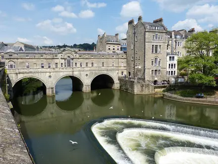
Neuchâtel
Neuchâtel is one of the major practical hubs on the northern half of the trail and a strong candidate for a rest or resupply night. It sits at the transition from Jura country into the Three-Lakes region.
The city is listed among the route’s major rail hubs, so it is useful for joining, leaving or section-hiking the trail. It should offer the widest accommodation and food choice since Porrentruy, making it a good place to deal with laundry, supplies and weather-related itinerary changes.
Murten/Morat
Murten/Morat is the bilingual lake-region stop after Neuchâtel. Its position in the Three-Lakes area makes it a natural overnight between the Seeland and the approach to Bern.
It is a good place to stay if following the official stages, with more practical appeal than a purely rural stop. Check accommodation and restaurant opening times before travelling, particularly if arriving outside the main visitor season.
Laupen
Laupen is the stage end between Murten/Morat and Bern. It is useful as a short, controlled stop before entering the capital rather than pushing directly into a busier urban night.
Accommodation and evening food should be planned in advance, as it is not one of the route’s major hubs. For section walkers, current public transport connections should be checked before using Laupen as a start or finish point.
Bern
Bern is one of the most important overnight stops on the whole route. The trail passes through the Swiss capital roughly a third of the way through the journey, with the UNESCO-listed Old Town and the Aare loop directly relevant to the walk.
This is one of the best places for a rest day, laundry, major food resupply, replacement gear and itinerary changes. Bern is also a major rail hub, making it the easiest northern-half point for joining or leaving the Trans Swiss Trail.
Worb
Worb is the first official stop after Bern as the trail leaves the capital region and heads towards the Emmental. It is a practical stage end for walkers who do not want a long first day out of Bern.
Because it sits close to a major urban area, it is a useful place for flexible staging, but accommodation should still be arranged before arrival. If using Worb for public-transport access, check current local connections before travelling.
Lützelflüh
Lützelflüh is an Emmental overnight stop between Worb and Langnau im Emmental. This part of the trail is more rural, with rolling dairy farmland and smaller settlements.
It is a good place for a quiet village night, but services are not comparable with Bern or Neuchâtel. Book accommodation ahead and check whether dinner is available at the lodging or nearby.
Langnau im Emmental
Langnau im Emmental is one of the more useful bases in the Emmental section. It sits before the route continues into smaller settlements and towards the Entlebuch and Alpine foothills.
For walkers managing food, laundry or schedule changes, Langnau im Emmental is a better bet than the smaller village stops either side. It is also a sensible place to review weather and bookings before the more rural stages to Eggiwil, Schangnau and Sörenberg.
Eggiwil
Eggiwil is a rural stage end after Langnau im Emmental. The stage from Eggiwil to Schangnau is one of the harder official stages on the route, so a comfortable overnight here is useful before continuing.
Do not treat Eggiwil as a guaranteed resupply point without checking opening times. Arrange accommodation and food in advance, and carry enough snacks for the following day.
Schangnau
Schangnau sits between Eggiwil and Sörenberg as the route moves deeper into the hill country before the Entlebuch. It is a useful stop for keeping the stages manageable.
Services are likely to be limited and seasonal patterns may matter more here than in the towns. Book ahead, check dinner arrangements, and do not arrive late assuming there will be multiple alternatives.
Sörenberg
Sörenberg is the key overnight stop in the Entlebuch section before the route crosses towards Giswil. The surrounding area is part of the wider Entlebuch landscape, one of the route’s classic Swiss countryside sections before the central mountains.
Accommodation is more important to secure here than in the larger towns, particularly in summer. This is a sensible place to check mountain weather, next-day conditions and public transport options before continuing towards Lake Lucerne country.
Giswil
Giswil is the stage end after Sörenberg and a useful valley stop before the route continues to Flüeli-Ranft. It gives a more settled overnight after the hillier Entlebuch stage.
Use Giswil for a practical reset if the preceding rural nights have had limited services. Current accommodation, food and transport options should be checked before travelling.
Flüeli-Ranft
Flüeli-Ranft is a hillside pilgrimage hamlet above the Melchaa gorge, linked with Niklaus von Flüe, or Brother Klaus. It is one of the more distinctive small overnight stops on the route rather than a large service centre.
Staying here makes sense for walkers following the official stages, but accommodation and food should be booked and checked in advance. Its appeal is the setting and cultural significance; its limitation is that it should be planned like a small village, not a town.
Stans
Stans is the next major-feeling stop after the rural and pilgrimage villages around Flüeli-Ranft. It is a practical overnight before the longer stage to Seelisberg and the Lake Lucerne section.
This is a good place to make sure food, weather and accommodation are organised for the next two days. The wider Lake Lucerne area has strong public-transport links, including lake-boat connections, but exact timings should be checked before relying on them.
Seelisberg
Seelisberg is a high balcony stop above Lake Lucerne, with the route taking in wooded shores, the Risleten gorge and lake views in this part of the journey. It is a scenic overnight and a useful staging point before the longer continuation to Erstfeld.
Because it is not a large town, book accommodation ahead and check meal arrangements. Weather can also affect how enjoyable this section feels, so avoid planning it as a rushed late-evening arrival.
Erstfeld
Erstfeld is the stage end after Seelisberg and a practical valley stop before the Reuss-valley approach to Wassen and Andermatt. It marks the route’s movement towards the Gotthard section.
This is a sensible place to reorganise before the Alpine crux of the trail. Accommodation and food should be confirmed before arrival, and public transport details should be checked if using Erstfeld as a section break.
Wassen
Wassen sits on the approach to Andermatt, between Erstfeld and the shorter official stage up to Andermatt. It is a useful overnight because it lets walkers tackle the next section without combining too much ascent or mountain logistics into one day.
Services are more limited than in Andermatt, so plan food and lodging before committing to the stop. The following stage enters the dramatic Schöllenen gorge and Devil’s Bridge area, so an early start from Wassen can be worthwhile.
Andermatt
Andermatt is the key base before the Gotthard Pass and one of the most important planning stops on the entire trail. It is listed among the route’s major rail hubs and is the natural place to check weather, snow conditions, accommodation and onward timing before going over the pass.
This is the best place to take a cautious pause if conditions on the Gotthard are poor. Book ahead in the main summer season and do not leave pass-day food and equipment checks until the morning of departure.
Gotthard Pass / Passo del San Gottardo
The Gotthard Pass / Passo del San Gottardo is the high point of the Trans Swiss Trail at about 2,090 m. It is reached from Andermatt by the historic cobbled mule path and followed by the descent towards Airolo via the cobbled Tremola hairpins.
Any overnight, food or hut-style services at pass height should be treated as seasonal and checked before travelling. The snow-free walking window is roughly July to October, and pass conditions should be checked before committing to this section.
Airolo
Airolo is the first major Ticino stop after the Gotthard descent and an important recovery point after the route’s physical crux. It is listed among the route’s major rail hubs, making it useful for section hikers and for anyone needing to pause after the pass.
Accommodation and food options should be more practical here than on the pass or in the small Strada Alta villages that follow. It is a good place to switch mentally and logistically into the Italian-speaking part of the route.
Osco
Osco is a high-level village on the Strada Alta Leventina section, above the valley floor. It is a rewarding overnight for walkers who want to stay on the balcony route rather than dropping down for services.
Plan it carefully: accommodation and evening food can be limited, and there may be fewer alternatives than in Airolo or Biasca. Carry enough food and cash to avoid depending on one small outlet being open.
Anzonico
Anzonico is another Strada Alta Leventina stop, positioned between Osco and Biasca. Like Osco, it is valuable for keeping to the high-level trail and avoiding unnecessary descent into the valley.
Treat Anzonico as a small-village overnight. Book ahead, confirm dinner and breakfast, and check public transport before travelling if it forms a start or finish point.
Biasca
Biasca is the main practical stop after the Strada Alta Leventina villages and is listed among the route’s major rail hubs. It sits before the route continues south towards Bellinzona.
This is a good place for a proper resupply, laundry stop or itinerary adjustment after the thinner upper Leventina section. It is also a logical bail-out or restart point if weather or time affects the Gotthard and Leventina stages.
Bellinzona
Bellinzona is the Ticino capital and one of the best overnight stops in the southern half of the route. It is also near the route’s lowest point, around 235 m, and is known for its three medieval castles: Castelgrande, Montebello and Sasso Corbaro.
The city is a major rail hub, so it is excellent for rest days, accommodation choice, food shopping and transport flexibility. If the route has been walked continuously from Porrentruy, Bellinzona is a sensible place to recover before the final hill-and-lake stages towards Lugano and Mendrisio.
Tesserete
Tesserete is the stage end between Bellinzona and Lugano. It gives a useful overnight in the southern Ticino hills before the route reaches the larger services of Lugano.
Accommodation and food should be checked before travelling, as it is not one of the route’s major hubs. It is a good place to use the official staging rather than pushing too far into the Lugano area at the end of a long day.
Lugano
Lugano is the largest and most useful service stop near the end of the trail, and it is listed among the route’s major rail hubs. The official staging uses Lugano (Comano) at the end of one stage and Lugano (Paradiso) at the start of the next, so check the exact SwitzerlandMobility line and local transport before booking accommodation.
This is the best southern stop for a rest night, major resupply, laundry and transport changes. It also marks the start of the final lake-and-hill character of the route towards Morcote and Mendrisio.
Morcote
Morcote is the penultimate overnight stop, on Lake Lugano, before the final stage to Mendrisio. It is one of the most appealing late-route stops, with lakeside terraces and a strong sense of arrival in southern Ticino.
Because it is a smaller lakeside village rather than a transport hub, book accommodation ahead and check restaurant opening times. It is worth avoiding a rushed late arrival here, as the final stage to Mendrisio is best started with food and logistics already sorted.
Mendrisio
Mendrisio is the official southern finish of the current Route 2 in the Italian-speaking Mendrisiotto, close to the Italian border. It has its own railway station on the Bellinzona–Lugano–Chiasso line, with frequent trains to Lugano and onward connections south towards Milan and Malpensa.
Staying overnight in Mendrisio is useful if finishing late or if onward international travel is easier the next morning. If leaving immediately, check current train times before the final stage and allow enough margin for delays, food and collecting any stored luggage.
Getting to the Start
The Trans Swiss Trail starts in Porrentruy, in Canton Jura near the French border. The simplest approach is by rail: Porrentruy has its own railway station, and the official Route 2 waymarking can be picked up from the town for the first stage to St-Ursanne.
By train
Porrentruy is served by SBB trains on the line from Basel SBB via Delémont. From Basel SBB, the journey to Porrentruy is around 1 hour 15 minutes on direct services.
For most walkers arriving from outside Canton Jura, Basel SBB is the most practical rail gateway. Delémont is the key local interchange on the approach to Porrentruy, so it is also a useful fallback if planning an overnight stop before reaching the start.
Swiss rail connections are generally excellent, but do not assume late-evening options will suit a walking start the next morning. Current train times, platform changes and any engineering works should be checked before travelling.
By bus
There is no need to rely on a bus to reach the start if travelling to central Porrentruy, as the town is on the rail network. Buses may be useful for local accommodation outside the town centre or for walkers joining from nearby Jura villages, but specific local routes and evening/weekend frequencies should be checked before travelling.
If arriving late, plan around the train rather than assuming onward local transport will still be running. A taxi may be the practical final link for out-of-town accommodation, but availability and fares should be checked in advance.
By car
Porrentruy can be used as a road-access start point, but this is a point-to-point crossing finishing far away in Mendrisio, so leaving a car at the start is usually less convenient than travelling by train. The return journey from Ticino to the Jura is possible by Swiss public transport, but it adds a long transfer at the end of the hike.
Long-stay parking arrangements in Porrentruy are not something to improvise on arrival. If driving, arrange accommodation with parking or check official local parking rules before leaving a vehicle for multiple days or weeks. This should be checked before travelling.
From the nearest airport
For international arrivals, the practical planning principle is to choose an airport with straightforward rail access to Basel SBB or another major Swiss rail hub, then continue by train to Porrentruy via Basel/Delémont. The trailhead itself does not require a mountain transfer or private shuttle.
Allow enough time between landing and the final rail connection to Porrentruy, particularly if starting the walk the next morning. Flight delays, baggage collection and cross-city transfers can make a late arrival risky; current rail timetables should be checked before booking non-refundable accommodation.
Where to stay before starting
The most straightforward pre-hike overnight is Porrentruy itself. Staying in the start town lets you sort food, water, cash and any last-minute kit before walking the first stage to St-Ursanne.
Basel SBB or Delémont can also work for a late arrival, but they mean beginning the hike with a rail transfer before the first walking day. That is manageable, but less relaxed than waking up already at the start.
Accommodation in Switzerland can be expensive and summer rooms should not be left too late, especially if the start date is fixed. Book the first night in Porrentruy ahead and check the exact walking line from your accommodation to the Route 2 signs before setting out.
Getting Home from the Finish
By train
Mendrisio is the simplest finish point logistically: the trail ends in a town with its own railway station on the Bellinzona–Lugano–Chiasso line. This makes it straightforward to leave the route without needing a road transfer from the final stage.
Trains run frequently to Lugano, with a typical journey of about 20 minutes. From Lugano, onward rail connections continue north through Ticino towards Bellinzona and the rest of Switzerland, and south towards Chiasso, Milan and Milan Malpensa.
If the final day from Morcote to Mendrisio runs late, check the current SBB timetable before committing to onward travel the same evening. International connections, airport links and late-night services are timetable-dependent and should be checked before travelling.
By bus
A bus is unlikely to be the main way to leave Mendrisio, because the railway station is the key onward transport link. Local buses may be useful for reaching accommodation, repositioning within the Mendrisiotto, or connecting from the exact point where the walking day finishes to the station, but routes and evening frequency should be checked before travelling.
If finishing late, do not assume local bus services will still be convenient. Plan the final stage with enough margin to reach Mendrisio station, or book accommodation in Mendrisio and travel on the following morning.
By car/taxi
For walkers who left a car at the start, retrieving it from Mendrisio means crossing much of Switzerland back to Porrentruy, so the train is usually the more practical option. Both ends of the Trans Swiss Trail are on the rail network, which is one of the route’s major logistical advantages.
Taxis can be useful if staying outside the centre, if arriving after local public transport has thinned out, or if tired legs make the last town transfer unattractive. Availability and fares should be checked locally before relying on a taxi, especially for a late finish.
From the nearest airport
For flights after the hike, the most relevant onward airport connection from the finish is towards Milan Malpensa via the Ticino rail corridor and onward connections south. Mendrisio also has fast access by train to Lugano, from where wider Swiss and cross-border rail connections can be made.
Airport routings, interchange times and ticketing can change, so check the current SBB and airport-rail timetables before booking a same-day flight. After a 17 km final stage from Morcote, an early flight the next morning is usually less risky than trying to connect to an evening departure with no buffer.
Where to stay at the finish
Staying overnight in Mendrisio is the safest option if the final stage is being walked at a relaxed pace, if weather is poor, or if onward trains and flight connections are tight. It also avoids turning the last day of a 488 km trail into a race for transport.
If accommodation in Mendrisio is limited or expensive, Lugano is an easy onward rail option at about 20 minutes by train and has better onward transport connections. Book ahead in busy summer and autumn periods, and confirm current train times before deciding whether to stay in Mendrisio or continue to Lugano after finishing.
Which Direction Should You Walk?
The Trans Swiss Trail is designed and signed as SwitzerlandMobility Route 2 from Porrentruy to Mendrisio, and that is the best default direction for most end-to-end walkers. The route can be walked in reverse without major navigation or transport problems, but the standard north-to-south direction gives the cleanest progression and the most satisfying build-up to the Alpine section.
Standard direction: Porrentruy to Mendrisio
Starting in Porrentruy gives a gradual opening through the Jura, the Doubs valley and the Franches-Montagnes before the easier lake and lowland sections around Neuchâtel, Murten/Morat, Laupen and Bern. This is useful on a 488 km trail: the first third allows most walkers to settle into daily rhythm before the higher, more committing middle stages.
The scenery also builds naturally. The route moves from French-speaking Jura country into the German-speaking Bern region, then through Emmental, Entlebuch, the Lake Lucerne hinterland and up towards Andermatt and the Gotthard Pass / Passo del San Gottardo. After the high point, the descent into Airolo, the Strada Alta Leventina, Bellinzona, Lugano, Morcote and finally Mendrisio gives a strong southward finish in Italian-speaking Ticino.
The Gotthard section works particularly well this way. You approach the pass after more than twenty stages of walking, climb from Andermatt on the historic cobbled mule path, then descend the Tremola hairpins towards Airolo. The pass is still the key seasonal constraint whichever way you walk; snow-free conditions are generally a July-to-October matter, and pass conditions should be checked before travelling.
Reverse direction: Mendrisio to Porrentruy
Walking from Mendrisio to Porrentruy is perfectly feasible. Both ends are on the railway, the trail is waymarked, and Switzerland’s dense rail, postbus and lake-boat network makes section logistics workable in either direction.
The main drawback is pacing. In reverse, the southern Ticino hills, the Strada Alta and the climb towards the Gotthard come relatively early, before most walkers have had much time to build trail fitness. You also meet the thinnest, more seasonal Alpine accommodation belt sooner, so booking discipline matters from the first week rather than later in the hike.
The reverse direction does have one advantage if a walker’s dates are fixed around the Gotthard. Starting in Ticino may make sense if accommodation or weather windows line up better from the south, or if the aim is to complete selected southern and central stages rather than a continuous thru-hike. This should be checked against current accommodation and transport timetables before travelling.
Transport, accommodation and weather considerations
Transport is not a strong reason to choose one direction over the other. Porrentruy has its own station on the SBB line from Basel/Delémont, while Mendrisio is on the Bellinzona–Lugano–Chiasso line with frequent trains to Lugano and onward connections south. Major rail hubs on or near the route include Bern, Lucerne, Andermatt, Airolo, Biasca, Bellinzona and Lugano.
Accommodation flow slightly favours the official direction. The early Jura, Seeland and Bern-region stages give regular town and village stops before the more constrained Alpine middle section. In either direction, summer nights around Entlebuch, the Lake Lucerne hinterland, the Gotthard and the upper Leventina should be booked ahead.
Prevailing wind is not a useful planning factor for this route. Weather planning should focus instead on the high pass and seasonal snow: the Gotthard is the physical and logistical crux, and conditions there matter far more than direction.
Recommendation
Walk the Trans Swiss Trail in the official direction, Porrentruy to Mendrisio, unless there is a specific transport, accommodation or timing reason to reverse it. It gives the best landscape progression, a sensible fitness build-up before the Gotthard, and the strongest psychological finish as the route drops into Ticino and ends near the Italian border.
Accommodation Along the Route
The Trans Swiss Trail works well as an inn-to-inn walk. The official stages generally finish in towns or villages rather than remote trailheads, and Switzerland’s rail, postbus and lake-boat network makes it practical to adjust overnight stops if a village is full or too expensive.
Accommodation is a mix of hotels, guesthouses, auberges, Gasthöfe, alberghi, hostels and, in the higher sections, mountain inns or huts. The easiest booking is in the larger towns and transport hubs: Porrentruy, Neuchâtel, Bern, Langnau im Emmental, Stans, Andermatt, Airolo, Biasca, Bellinzona, Lugano and Mendrisio.
The thinner parts are the Jura villages, the Emmental and Entlebuch countryside, the Lake Lucerne hinterland, the Gotthard Pass / Passo del San Gottardo and the upper Leventina villages on the Strada Alta. In these areas, do not rely on turning up late in the day and finding a bed. Book summer and weekend nights ahead, especially around the Gotthard section and in Ticino.
Where booking matters most
The most important accommodation planning point is the Alpine middle of the route. From Schangnau through Sörenberg, Giswil, Flüeli-Ranft, Stans, Seelisberg, Erstfeld, Wassen, Andermatt, the Gotthard Pass / Passo del San Gottardo and Airolo, accommodation is more seasonal and less evenly spread than on the lower-country stages.
The pass night is particularly important. The route’s high point is around 2,090 m, and accommodation at altitude should be treated as limited and seasonal. Check opening dates, snow conditions and current availability before committing to an itinerary over the pass.
The upper Leventina stages after Airolo — Osco and Anzonico — also need forward planning. These are smaller overnight stops on a high-level route above the valley floor, so book ahead or be prepared to use public transport or a local taxi to reach a larger base if necessary.
Accommodation table
| Place | Accommodation level | Best for | Notes |
|---|---|---|---|
| Porrentruy | Good | Starting the route rested | Railway town near the French border; sensible first-night base before Stage 1. |
| St-Ursanne | Limited | Historic Jura overnight | Attractive early stop on the River Doubs; book ahead in busy periods. |
| Soubey | Limited | Keeping to the official stage rhythm | Small Jura village; do not assume spare rooms will be available on arrival. |
| Saignelégier | Good | Jura plateau services | One of the more useful stops in the Franches-Montagnes section. |
| St-Imier | Good | Reset night before the Three-Lakes approach | More practical than the smaller villages either side. |
| Chézard-St-Martin | Limited | Shorter stage into Neuchâtel next day | Village stop; check accommodation before fixing this as an overnight. |
| Neuchâtel | Good | Rest, laundry and wider choice | One of the strongest accommodation bases in the first third of the route. |
| Murten/Morat | Good | Lake-country overnight | Useful stop in the Three-Lakes region; weekends can be busier. |
| Laupen | Limited | Keeping the stage length into Bern moderate | Small-town stop before the capital; book rather than relying on walk-in availability. |
| Bern | Good | Rest day, resupply and flexible accommodation | The strongest mid-route accommodation hub, with excellent onward transport. |
| Worb | Limited | Short stage out of Bern | Works as a stage stop, but Bern may be easier if accommodation is tight. |
| Lützelflüh | Limited | Emmental village overnight | Rural accommodation pattern; book ahead. |
| Langnau im Emmental | Good | Emmental services and resupply | A practical base before the thinner Entlebuch and pre-Alpine stages. |
| Eggiwil | Limited | Official-stage pacing | Smaller rural stop; check availability before committing. |
| Schangnau | Limited | Positioning before Sörenberg | Accommodation is thinner in this part of the route. |
| Sörenberg | Limited | Entlebuch mountain-stage base | Seasonal pressure is possible; reserve summer nights in advance. |
| Giswil | Limited | Transition towards Central Switzerland | Useful stage stop, but not a place to leave accommodation to chance. |
| Flüeli-Ranft | Limited | Pilgrimage hamlet and quieter overnight | Small hillside stop above the Melchaa gorge; book ahead. |
| Stans | Good | Services before Lake Lucerne and Uri | Larger, more practical overnight than the surrounding smaller stops. |
| Seelisberg | Limited | Lake Lucerne balcony stop | Scenic but limited; reserve in advance, especially at weekends. |
| Erstfeld | Good | Reuss valley logistics | Useful valley base before the climb towards Wassen and Andermatt. |
| Wassen | Limited | Breaking the approach to Andermatt | Small stop in the Gotthard approach; check current accommodation. |
| Andermatt | Good | Key Alpine base before the Gotthard | One of the most important booking points on the whole route. |
| Gotthard Pass / Passo del San Gottardo | Limited | High-point overnight | Treat as seasonal mountain accommodation; check opening dates and conditions before travelling. |
| Airolo | Good | First Ticino valley base after the pass | Practical place to recover after the Tremola descent and prepare for the Strada Alta. |
| Osco | Limited | Strada Alta Leventina pacing | Small high-level stop; book ahead or plan a transport fallback. |
| Anzonico | Limited | Strada Alta Leventina pacing | Another small high-level overnight; do not rely on late availability. |
| Biasca | Good | Valley services and easier logistics | Stronger base after the upper Leventina stages. |
| Bellinzona | Good | Rest day, castles and transport | Major Ticino hub and one of the best places for a recovery night. |
| Tesserete | Limited | Positioning before Lugano | Smaller stop north of Lugano; check availability in advance. |
| Lugano / Comano / Paradiso | Good | Lake-city accommodation and rest | Best choice in southern Ticino before the final two stages. |
| Morcote | Limited | Lakeside overnight before Mendrisio | Attractive but potentially tight; book ahead in season and at weekends. |
| Mendrisio | Good | Finish night and onward travel | Railway town near the Italian border; practical end-point base. |
Using public transport to solve awkward gaps
Accommodation gaps are rarely a route-ending problem because almost every stage end is connected to Swiss public transport. If a planned village is full, it is often better to sleep in a larger town and return to the route the next morning rather than force an awkward long day.
This is especially useful around the smaller Jura, Emmental, Entlebuch and Leventina stops. Build some flexibility into the itinerary, but check current train, postbus and boat times before relying on an off-route overnight.
Luggage transfer and taxi options
The route is suitable for walkers carrying their own overnight kit, but it can also be adapted for lighter inn-to-inn walking. Do not assume that every small auberge, Gasthof or albergo will handle luggage movement automatically; arrange this directly with accommodation providers or local taxi operators where needed.
Taxi transfers are most useful where accommodation is full in smaller villages or where a walker wants to avoid sleeping at the Gotthard Pass / Passo del San Gottardo. Availability, cost and whether drivers will carry luggage should be checked before travelling.
For the smoothest luggage-supported itinerary, anchor nights in larger places such as Neuchâtel, Bern, Langnau im Emmental, Stans, Andermatt, Airolo, Biasca, Bellinzona, Lugano and Mendrisio, then use public transport or pre-arranged taxis to manage thinner rural sections.
Camping and Wild Camping
Camping is possible on the Trans Swiss Trail, but this is not the easiest way to walk Route 2 end to end. The route is built around Swiss villages, valley towns, public transport and guest accommodation, not a continuous chain of campsites at every stage end.
For most hikers, the practical approach is to use hotels, guesthouses, hostels and mountain inns as the default, then add the occasional campsite where it fits the stage. Anyone planning a full camping itinerary should check each overnight stop before committing to it.
Formal campsites
The route passes through many populated areas, including Neuchâtel, Murten/Morat, Bern, Stans, Andermatt, Airolo, Biasca, Bellinzona, Lugano and Mendrisio, so formal camping may be possible on or near some stages. However, no campsite should be assumed to sit exactly at a Route 2 stage end.
This matters because the official stages are already designed as walking days. A campsite several kilometres off-route can turn a moderate day into a long one, especially on the 20 km-plus stages such as Stans–Seelisberg, Seelisberg–Erstfeld, Biasca–Bellinzona and Bellinzona–Tesserete.
Book or contact campsites in advance where possible, especially in summer, around lakes and in the Alpine middle section. Opening dates, pitch availability and whether small backpacking tents are accepted should all be checked before travelling.
Wild camping: legality and practical reality
Wild camping should not be treated as a default plan on this trail. Route 2 crosses multiple cantons, municipalities, protected landscapes, farmland, forests, lakeside areas and high mountain ground, and the rules can change locally.
Permission is essential on private land, which includes much of the farmland through the Emmental, Entlebuch and many village approaches. In protected areas, including sensitive landscapes such as the UNESCO Entlebuch Biosphere, assume that camping and fires may be restricted unless local information clearly says otherwise.
The practical problem is as important as the legal one. Much of the route runs through settled valleys, farm tracks, lakeside paths, villages and transport corridors, where discreet and lawful wild-camping spots are limited. In these areas, use formal accommodation or an official campsite rather than trying to camp informally.
If local rules are unclear, ask the municipality, tourist office, accommodation provider or landowner. This should be checked before travelling.
Where camping makes most sense
| Section | Camping practicality | Planning note |
|---|---|---|
| Jura and Three-Lakes sections, including Porrentruy, St-Ursanne, Saignelégier, Neuchâtel and Murten/Morat | Moderate | Look for formal campsites near towns, lakes or valley settlements, but do not assume they are on-route or open year-round. |
| Bern, Emmental and Entlebuch | Limited to moderate | Expect a lot of farmland, villages and private land. Formal accommodation is usually the cleaner plan; wild camping should not be assumed acceptable. |
| Lake Lucerne hinterland, Stans and Seelisberg | Limited to moderate | Scenic but settled and often steep or wooded. Check formal camping options carefully before building an itinerary around them. |
| Gotthard section: Erstfeld, Wassen, Andermatt, Gotthard Pass / Passo del San Gottardo, Airolo | Weak for casual camping | This is the highest and most weather-sensitive part of the trail. Accommodation in Andermatt, on or near the pass, and in Airolo is a safer plan than relying on camping. |
| Ticino: Strada Alta Leventina, Biasca, Bellinzona, Lugano, Morcote and Mendrisio | Mixed | Valley and lake areas may offer formal options, but the route also passes through built-up, steep and private terrain. Check each night individually. |
The Gotthard and high sections
The Gotthard Pass / Passo del San Gottardo is the high point of the trail at about 2,090 m, and it is the least forgiving place to improvise. The walking window is roughly July to October, but snow, cold nights and fast-changing conditions can still affect plans.
A lightweight tent does not remove the need for a robust mountain-stage plan. The stages from Wassen to Andermatt, Andermatt to the Gotthard Pass and down to Airolo should be planned around known, available accommodation or a campsite that has been checked in advance.
Water and cooking
The route passes many towns and villages, so the simplest water strategy is to refill during the day at accommodation, cafés, shops or other confirmed services. Do not rely on every stream, lake or fountain as a safe drinking source, particularly through farmland and settled valleys.
Carry enough water for the full stage when crossing thinner sections, especially in the Entlebuch, around the Lake Lucerne hinterland, over the Gotthard and along the Strada Alta Leventina. A filter or treatment method is sensible for anyone camping, but it should not replace planning reliable refill points.
Cooking should be kept discreet and low-impact. Open fires are a poor fit for this route unless a local signed fireplace or official site clearly allows them, and fire bans or local restrictions must be followed. Use a stove only where permitted and safe, and never on dry grass, forest litter or near farm buildings.
Leave No Trace on Route 2
A camping itinerary on the Trans Swiss Trail needs particularly careful behaviour because the route crosses working landscapes as much as wild terrain. Camp only where allowed, arrive late, leave early and keep well away from houses, farmyards, livestock, crops and marked paths.
Pack out all rubbish, food waste and hygiene products. Human waste should be dealt with well away from water, paths and buildings, and never left visible. Soap, toothpaste and washing water should not go into streams, lakes or animal troughs.
Above all, do not let camping compromise access for other walkers. If a legal, low-impact overnight spot is not clearly available, use the nearest village accommodation, campsite or public transport connection instead.
Food, Water and Resupply
Food logistics on the Trans Swiss Trail are generally straightforward by long-distance hiking standards, but they change sharply between the larger valley towns and the thinner Alpine sections. Plan around stage ends rather than expecting frequent on-trail shops: many days finish in a village or town, but not every small settlement will have reliable supplies when you arrive.
The easiest resupply points are the larger towns and transport hubs on or close to the route, including Porrentruy, Neuchâtel, Bern, Langnau im Emmental, Stans, Andermatt, Airolo, Biasca, Bellinzona, Lugano and Mendrisio. These are the places to buy several days of snacks, check onward opening hours and reset your food bag before quieter rural stages.
Food availability by section
| Section | Food availability | Water availability | Notes |
|---|---|---|---|
| Porrentruy to Saignelégier | Moderate to good at stage towns; more limited between villages in the Jura and Doubs valley. | Carry enough for the full walking day; do not rely on untreated streams. | St-Ursanne and Saignelégier are useful planned stops, but Soubey should be treated more cautiously for resupply unless checked before travelling. |
| Saignelégier to Neuchâtel | Better as the route approaches larger settlements such as St-Imier, Chézard-St-Martin and Neuchâtel. | Usual village and accommodation refills are the safest plan. | Stock up properly in Neuchâtel before the Three-Lakes and Bern approaches. |
| Neuchâtel to Bern | Generally good, with larger towns and easier valley walking. | Refills are usually simplest at accommodation, cafés and town facilities. | Murten/Morat, Laupen and Bern make this one of the easier food-planning sections. Sunday and public-holiday hours still matter. |
| Bern to Langnau im Emmental | Good at the larger stage towns; variable in smaller rural places. | Carry normal day water and refill at accommodation or cafés where available. | Bern is a major resupply point. After Worb and Lützelflüh, check shop and restaurant hours rather than assuming late openings. |
| Langnau im Emmental to Sörenberg | More limited through the Emmental and Entlebuch villages. | Carry enough for the full stage, especially in warm weather. | Eggiwil, Schangnau and Sörenberg are stage ends, but rural opening hours can be short. Book accommodation and check evening meals in advance. |
| Sörenberg to Stans | Mixed: village services and accommodation food, with better options again at Stans. | Refill before leaving each overnight stop; natural water should be treated if used. | The terrain becomes more broken through the Lake Lucerne hinterland, so avoid starting with an empty food bag. |
| Stans to Andermatt | Moderate but with longer, more committing days, including the 24 km Seelisberg to Erstfeld stage. | Carry more than usual on longer days and refill whenever there is a reliable opportunity. | Erstfeld, Wassen and Andermatt are the key planning points before the Gotthard. Do not assume frequent food once away from settlements. |
| Andermatt to Airolo via Gotthard Pass / Passo del San Gottardo | Limited and seasonal around the pass. | Start each Gotthard day with a full water carry; treat any natural water. | This is the physical and logistical crux. Check current pass conditions, accommodation and opening hours before relying on food at altitude. |
| Airolo to Biasca via the Strada Alta Leventina | More limited in the high villages; better again at Biasca. | Carry enough for a full day on the balcony trail. | Osco and Anzonico are small stage stops, so plan meals and supplies ahead in Airolo or Biasca. |
| Biasca to Mendrisio | Generally good in the Ticino towns, especially Bellinzona, Lugano and Mendrisio; more limited between them. | Carry extra in hot weather on the southern hill and lake stages. | Bellinzona and Lugano are major resupply points before the final stages through Morcote to Mendrisio. |
How much food to carry
For most stages, carry lunch, high-energy snacks and an emergency meal or substantial spare food. The official stages are commonly around 14–20 km, so a single day’s food is usually enough where dinner and breakfast are arranged at accommodation.
Carry more food where the route enters quieter rural or mountain sections: Langnau im Emmental to Sörenberg, the Lake Lucerne hinterland, Erstfeld to Airolo over the Gotthard, and the Strada Alta Leventina between Airolo and Biasca. In these areas, small village shops, restaurants and mountain inns may have seasonal or restricted hours.
Do not plan a long day around finding lunch at an unverified hamlet. If a shop, café, Gasthof, auberge, albergo or mountain inn is essential to the day’s plan, this should be checked before travelling.
Water planning
A practical default is to start each stage with enough water to walk the full day if necessary. On typical moderate stages, many walkers will be comfortable carrying around 1.5–2 litres, but hot weather, long climbs and exposed southern Ticino stages may require more.
The Gotthard section deserves particular caution. The climb from Andermatt to the Gotthard Pass / Passo del San Gottardo and the descent towards Airolo are mountain days, and services around the pass are seasonal. Leave Andermatt and the pass area with full bottles rather than depending on finding water en route.
Natural water is present in parts of the route’s river, lake, farm and mountain landscapes, but it should not be assumed safe to drink untreated. Where water is taken from streams, lakes or troughs, filter or treat it, especially in grazing areas, farmland and settled valleys.
Opening hours, Sundays and rural timing
Switzerland is expensive, and small rural stops may not be geared around late-arriving hikers. Many shops have reduced hours on Sundays, public holidays and sometimes over lunch; mountain and village restaurants may also close on rest days or outside the main summer season.
The safest routine is to buy the next day’s lunch before dinner, refill bottles before leaving accommodation, and keep one spare meal in the pack. In larger towns such as Bern, Andermatt, Bellinzona, Lugano and Mendrisio, use the wider choice to restock fully rather than carrying shortages into the next rural section.
Terrain, Conditions and Difficulty in Practice
The Trans Swiss Trail is best understood as a long endurance walk rather than a technical mountain route. Most of the route uses easy waymarked hiking paths, forest and meadow tracks, farm lanes, lakeside paths and village approaches, with the more serious mountain character concentrated around the Reuss valley, Andermatt and the Gotthard Pass / Passo del San Gottardo.
The official overall grade is easy in technical terms, with mostly T1 walking, but the full crossing is still demanding. The challenge comes from repeating day after day over 488 km, with about 17,600 m of total ascent, and from managing the higher Alpine section in a suitable weather and snow window.
Underfoot: what the walking is really like
Expect a varied mix rather than a single consistent trail surface. In the Jura and Franches-Montagnes the walking alternates between limestone hill country, pasture, spruce woodland and rural tracks. Around Neuchâtel, Murten/Morat and the Three-Lakes region, the ground becomes gentler, with more lakeside ways, vineyard country, farmland and flatter sections.
Through the Bern region, Emmental and Entlebuch, the route is predominantly a countryside walk: rolling dairy farmland, meadow paths, forest tracks and minor lanes between villages. This is not technically difficult walking, but the constant small climbs and descents add up, especially when carrying a multi-day pack.
The Central Switzerland and Gotthard section is the physical crux. The route climbs through the Reuss valley towards Andermatt, passes the Schöllenen gorge and Teufelsbrücke, then reaches the Gotthard Pass / Passo del San Gottardo at about 2,090 m. Here the walking includes steeper mountain ground, historic cobbled mule paths and the cobbled Tremola hairpins dropping towards Airolo.
In Ticino, the Strada Alta Leventina keeps to a higher balcony line above the Leventina valley before the route continues via Biasca, Bellinzona, Lugano, Morcote and Mendrisio. This southern section is still non-technical, but it remains hilly, and hard surfaces become more noticeable through settlements, lakeside areas and historic villages.
| Section | Typical terrain | Practical difficulty |
|---|---|---|
| Porrentruy to Saignelégier | Jura hills, Doubs valley, woodland, pasture and rural tracks | Moderate day-walking; some hilliness early on |
| Saignelégier to Neuchâtel | High Jura plateau, spruce woods, open pasture, descent towards lake country | Generally straightforward, with mixed surfaces |
| Neuchâtel to Bern | Three-Lakes country, farmland, lakeside ways, towns and villages | Easier navigation and gentler terrain; more hard-surface walking in places |
| Bern to Sörenberg | Emmental and Entlebuch farmland, meadow paths, forests and lanes | Rolling terrain; cumulative ascent is the main strain |
| Sörenberg to Seelisberg | Forests, gorges, Lake Lucerne hinterland and balcony ground | More varied and hillier; weather can make paths slower |
| Seelisberg to Airolo | Reuss valley, Schöllenen gorge, Andermatt, Gotthard mule path, Tremola | The main mountain section; altitude, cobbles, snow risk and longer climbs matter |
| Airolo to Mendrisio | Strada Alta Leventina, Ticino hills, valley towns, lakeside and village paths | Hilly but generally non-technical; heat and hard surfaces can be tiring |
Climbs, descents and cumulative fatigue
No single climb makes the route an alpine expedition, but the total ascent is substantial. The repeated rise-and-fall through the Jura, Emmental, Entlebuch and Ticino often feels harder in practice than the map profile suggests, because there are few completely flat days outside the lake and valley sections.
The biggest sustained mountain effort comes around Andermatt and the Gotthard Pass. The stage from Andermatt to the Gotthard Pass / Passo del San Gottardo is short in distance at about 13 km, but it gains height to the route’s high point and should be treated as a mountain day, not as an easy half-day stroll.
Descending is also a factor. The cobbled and paved historic surfaces around the Gotthard and Tremola can be hard on knees and feet, especially in wet conditions or with a heavy pack. Poles are useful for many walkers on the longer descents, even though the route is not technically difficult.
Road walking and hard surfaces
This is a national through-route linking real towns, villages and valleys, so some hard-surface walking is unavoidable. Expect paved lanes, village streets, lakeside promenades, farm access tracks and historic cobbled routes, particularly around settlements and on the Gotthard descent.
The advantage is reliable progress and frequent services. The drawback is impact fatigue: shoes need enough cushioning for long days on mixed surfaces, not just grip for soft trails. Lightweight trail shoes can work well for fit walkers in good conditions, but footwear should still handle wet grass, gravel, cobbles and stony mountain paths.
Mud, wet grass and slippery ground
The route is not primarily a boggy or marshy walk. However, forest paths, meadow crossings and farm tracks can become muddy after rain, especially in the Jura, Emmental, Entlebuch and wooded sections above Lake Lucerne.
Wet grass can be as tiring as mud over a long day, particularly through pasture and meadow country. Cobbles on the Gotthard mule path and Tremola can also become slippery when wet, so the mountain stages deserve more caution in poor weather than their technical grade implies.
Rocky, steep or exposed terrain
Most of the Trans Swiss Trail is not exposed and does not require scrambling. The route is designed as a waymarked hiking trail, and the general walking standard is easy rather than alpine technical.
The exception in feel, if not in formal difficulty, is the Gotthard approach and descent. Around the Schöllenen gorge, Andermatt, the pass and the Tremola, the terrain becomes steeper, rockier and more mountainous. Bad weather, lingering snow or poor visibility can quickly make this section feel much more serious.
Livestock, pasture and rural access
Much of the middle part of the trail passes through working farming country, especially the Jura, Emmental and Entlebuch. Expect open pasture, farm tracks and livestock areas rather than a sealed-off wilderness path.
Where the trail passes through grazing land, give animals space, keep to the marked route and leave any gates or barriers as found. Dogs, where permitted and taken on the route, need careful control around livestock. Local rules and seasonal restrictions should be checked before travelling.
Seasonal conditions
Summer and autumn are the practical seasons for completing the whole route. The decisive point is the Gotthard section: the high pass area is reliably snow-free only around July to October, and conditions should be checked before committing to the mountain stages.
Earlier or later in the year, lower sections may still be walkable, but the full continuous crossing can be blocked or made unsafe by snow around the Gotthard. Autumn can bring excellent walking conditions, but shorter days make the longer stages and public-transport connections less forgiving.
In warm summer weather, the lower lake, valley and Ticino sections can feel harder than their gradients suggest. Carry enough water between villages, start early on exposed hot days, and do not underestimate long hard-surface stages simply because they sit below the high mountains.
What makes the route easier
Waymarking and public transport remove much of the usual logistical pressure. The route follows SwitzerlandMobility national Route 2, marked with green-and-white signs and the red route number 2, and many stage ends have rail, postbus or boat links nearby or within reach.
That means difficult weather, tired legs or accommodation gaps can often be managed by shortening, combining or skipping stages. This flexibility is one of the main reasons the Trans Swiss Trail is suitable for a first long-distance crossing, provided overall fitness is solid.
What makes the route harder
The main difficulty is consistency. Walking 30 or more days across a country requires more resilience than a single hard mountain weekend, even when the paths are mostly easy.
The hardest practical combination is a heavy pack, repeated ascent, wet surfaces and hard cobbles or tarmac underfoot. The Gotthard stages add altitude and snow-season constraints, while the longer official stages, including days of around 20 km or more, need realistic pacing and early starts when conditions are poor.
Weather and Best Time to Walk
The main seasonal constraint on the Trans Swiss Trail is not the lowland start or finish, but the central Alpine section over the Gotthard Pass / Passo del San Gottardo at about 2,090 m. The route as a full end-to-end walk is best planned for summer to early autumn, with the Gotthard section falling inside its roughly July to October snow-free window.
For most walkers, July, August and September are the most practical months for a continuous Porrentruy–Mendrisio itinerary. Earlier or later starts may be possible on lower sections, but they become much less reliable for a full crossing because of snow, shorter days and seasonal accommodation in the higher middle of the route.
Best months for a full thru-hike
| Period | Practical verdict |
|---|---|
| June | Lower sections through the Jura, Three-Lakes region, Bern and Emmental may be walkable, but a full thru-hike is risky unless the Gotthard days fall later. Pass conditions should be checked before travelling. |
| July–August | The most straightforward period for a complete walk. Expect the best chance of a snow-free Gotthard crossing, but also busy summer accommodation and the need to manage heat on lower valley, lake and Ticino stages. |
| September | Often the strongest planning window: the Gotthard is still within the normal snow-free season, lower stages are less hot, and the long route remains realistic if accommodation is booked sensibly. |
| October | Possible in some years, especially early in the month, but daylight is shorter and the Gotthard can become uncertain. Seasonal accommodation and pass conditions must be checked carefully. |
| November–May | Not realistic for the full route as a continuous hike. Lower stages may be walked as day hikes in suitable conditions, but the Alpine middle section is the limiting factor. |
Snow and the Gotthard section
The route’s high point is the Gotthard Pass / Passo del San Gottardo, reached from Andermatt and followed by the descent towards Airolo on the historic Tremola side. This is the weather crux of the trail: snow, late lying patches, cold wind and poor visibility matter far more here than on the earlier lowland stages.
Do not plan the whole route around a fixed Gotthard crossing without checking current conditions shortly before arrival. This should be checked before travelling. If conditions are poor, Switzerland’s rail and postbus network makes it practical to pause, shorten or bypass a stage rather than forcing the pass in bad weather.
Heat, storms and wet ground
In high summer, the hotter days are most likely to affect the lower and more open sections: the Three-Lakes region around Neuchâtel and Murten/Morat, the Bern and Emmental approaches, and especially Ticino after Airolo, including Biasca, Bellinzona, Lugano and Mendrisio. Start early on exposed or longer stages, carry enough water between villages, and avoid leaving the steepest climbs for the hottest part of the day.
Mountain weather can change quickly around the Entlebuch, Lake Lucerne hinterland, the Reuss valley and the Gotthard. Afternoon storms are a practical concern on long summer days, particularly where the route climbs away from villages and public transport. The longer stages, such as Stans–Seelisberg, Seelisberg–Erstfeld, Biasca–Bellinzona and Bellinzona–Tesserete, deserve an early start when the forecast is unsettled.
After rain, the route remains largely non-technical, but surfaces can still slow progress. Forest and meadow paths become muddy, farm tracks can be greasy, and the cobbled historic routes around the Gotthard and Tremola can be slippery when wet.
Fog, visibility and navigation
The Trans Swiss Trail is well waymarked as SwitzerlandMobility Route 2, but fog and low cloud can still affect decision-making in the higher and more open sections. Around the Gotthard, poor visibility reduces the margin for relaxed walking even on a non-technical route.
Carry offline mapping as well as following the green-and-white Route 2 signs. In fog, rain or early snow, the safest decision may be to wait, use public transport to adjust the day, or split the stage.
Daylight and itinerary timing
A 28–32 day itinerary means weather delays are likely to matter more than on a short trail. Build in flexibility, especially before the Gotthard section and in Ticino, where several later stages are still full walking days rather than a gentle run-out.
By October, shorter daylight makes the longer stages less forgiving. If walking late in the season, avoid over-combining stages, start early, and check that accommodation is open before committing to remote or higher overnight stops.
Accommodation and seasonal services
Accommodation is generally plentiful in valley towns and larger villages, but the Alpine middle of the route is thinner and more seasonal. The Entlebuch, Lake Lucerne hinterland, Gotthard and upper Leventina sections should be booked ahead in summer, particularly if walking to a fixed schedule.
Late-season walkers should be especially cautious with mountain inns, huts and smaller village accommodation. Opening dates, food availability and transport timetables can change; these should be checked before travelling.
Safety Notes
The Trans Swiss Trail is largely non-technical, but it is still a 488 km crossing with long cumulative fatigue, changing weather and one genuinely mountainous section around the Gotthard. Treat it as a long-distance mountain-and-valley walk rather than a casual series of town-to-town strolls.
Use 112 for emergency help in Switzerland. Carry a charged phone, a power bank, offline mapping and the day’s accommodation and transport details, especially before the thinner middle sections through Entlebuch, the Lake Lucerne hinterland, the Gotthard and the upper Leventina.
Weather, altitude and the Gotthard
The main safety crux is the high section from Andermatt over the Gotthard Pass / Passo del San Gottardo to Airolo. The pass is about 2,090 m, and the practical snow-free window is roughly July to October; outside that, snow and poor conditions can make the route unsuitable for ordinary hiking.
Check the local forecast, pass conditions and any route closures before committing to the Gotthard stages. A short stage on paper can still feel serious in cold rain, wind or low cloud, particularly on the historic cobbled mule path and the descent towards Airolo via the Tremola hairpins.
Weather can change quickly at altitude. Carry a waterproof jacket, warm layer, hat and gloves even in summer, and do not rely on valley conditions in Andermatt or Airolo as proof that the pass itself will be comfortable.
Heat, sun and cold
This route crosses very different climates: Jura hills, the Three-Lakes region, Emmental and Entlebuch farmland, Central Switzerland, the Gotthard and southern Ticino. Summer heat can be a factor on open farmland, lakeside paths and the later Ticino stages around Bellinzona, Lugano, Morcote and Mendrisio.
Start early in hot weather, carry enough water between villages and avoid assuming every farm hamlet has a shop or café. Conversely, cold rain and wind are realistic hazards on the higher central stages, particularly near the Gotthard.
Mobile signal and remoteness
Switzerland has excellent infrastructure, and many stage ends are linked to rail, postbus or lake transport. That makes escape routes unusually good for a long-distance trail, but it does not remove the need to plan each day properly.
Mobile signal should not be treated as guaranteed in gorges, forests, high valleys or on the more exposed mountain sections. Download the route in advance, save key phone numbers offline and let someone know the planned stage when walking alone.
The thinner accommodation and service areas are the ones to respect most: Entlebuch, the Lake Lucerne hinterland, the Gotthard and the upper Leventina. In these areas, check where the next food, water, shelter and transport options are before leaving the stage start.
Roads, cobbles and shared tracks
The route uses a mix of hiking paths, farm tracks, gravel ways, lakeside paths and paved or cobbled historic routes. Take extra care where the trail joins village roads, farm lanes or pass roads, and be visible in poor light or bad weather.
The Gotthard section includes cobbled mule paths and the Tremola descent towards Airolo. Cobbles can be tiring and slippery when wet, so trekking poles and footwear with reliable grip are useful here.
Livestock and farmland
The Jura, Emmental and Entlebuch sections pass through working pasture and dairy country. Expect gates, farm tracks and livestock in season.
Give animals space, close gates behind you, avoid walking between cows and calves, and keep dogs under close control. If livestock blocks the path, detour calmly rather than pushing through the herd.
Rivers, lakes and gorges
The route follows or passes close to rivers, lakes and gorges, including the Doubs valley, the Aare around Bern, Lake Lucerne, the Reuss valley, Ticino valleys and Lake Lugano. These are not tidal hazards, but wet rock, steep banks, fast water after rain and cold lake water can still be dangerous.
Do not step onto wet river stones for shortcuts or photographs, and take care on gorge paths and lakeside sections after heavy rain. Swim only where it is clearly safe and permitted locally.
Solo hiking
Solo walking is realistic on this route because it is waymarked and well served by Swiss public transport. The main risks for solo hikers are not navigation difficulty, but fatigue, changing weather and overcommitting to a long stage when tired.
Build in short days or rest options if walking the whole route continuously. On the mountain stages, leave a clear plan with someone and avoid pressing on over the pass if the forecast or conditions deteriorate.
Check before setting off each day
Before leaving each stage start, check:
- the local weather forecast, including rain, wind and temperature at higher altitude;
- snow and pass conditions before the Gotthard stages;
- the official route status and any diversions on the SwitzerlandMobility route;
- the length of the day and available daylight;
- where food and water can be obtained;
- whether accommodation at the end of the day is open and booked;
- the nearest rail, postbus or boat escape option if the stage needs to be shortened;
- phone battery, offline maps and emergency contact details.
For current transport times, seasonal accommodation and any temporary path closures, this should be checked before travelling.
Gear Recommendations
The Trans Swiss Trail is long rather than technical. Gear should be chosen for 488 km of repeated daily walking on mixed surfaces: forest and meadow paths, farm tracks, lakeside ways, gravel, paved sections and the cobbled mule routes around the Gotthard Pass / Passo del San Gottardo.
The key challenge is variation. A kit that feels ideal on the flat Seeland stages may be too light for cold wind and wet weather above Andermatt, while heavy alpine equipment will feel unnecessary through Bern, Emmental and Ticino.
Footwear
Lightweight hiking shoes or trail shoes with good cushioning suit most of the route, provided they have reliable grip and are comfortable for back-to-back long days. The trail is mostly easy T1 walking, so stiff mountaineering boots are not normally necessary.
Do not underestimate hard surfaces. Lakeside paths, farm tracks, village streets and the historic cobbles on the Gotthard and Tremola can be tiring underfoot, especially late in a multi-week walk. Choose footwear with enough midsole protection for repeated days on gravel, tarmac and stone.
Waterproof shoes can be useful in wet grass, forests and cooler autumn conditions, but quick-drying footwear is also a valid summer choice. Whatever the style, footwear should already be broken in before starting from Porrentruy.
Waterproofs and warm layers
Carry proper waterproofs throughout the trail, not just for the Alpine section. A waterproof jacket is essential, and waterproof trousers are strongly recommended for sustained rain, cool mornings and exposed days around the Gotthard.
A warm layer is needed even in summer. The route reaches about 2,090 m at the Gotthard Pass / Passo del San Gottardo, and conditions there can feel very different from Bern, Bellinzona or Lugano on the same trip.
A practical clothing system is:
| Layer | Route-specific use |
|---|---|
| Lightweight base layer | Daily walking across warm lowland and hill stages |
| Fleece or active mid-layer | Cool mornings, shaded forest sections, higher ground |
| Insulated jacket or warm spare layer | Stops, mountain inns, the Gotthard section and autumn itineraries |
| Waterproof shell | Rain, wind and sudden changes in the Alpine middle section |
| Hat and gloves | Sensible for the Gotthard and late-season crossings |
Navigation
The route is waymarked as SwitzerlandMobility national hiking Route 2, with green-and-white signs carrying the red route number 2. Navigation is generally straightforward, which is one reason the trail works well as a first long thru-hike.
Even so, carry a backup. A phone with offline mapping and the SwitzerlandMobility route loaded is the minimum sensible setup; a power bank is strongly recommended for anyone walking full days, using the phone for maps, train times and accommodation details.
In poor weather, forest, towns and complex transport corridors can all make it easy to miss a turn. Do not rely only on memory from the previous signpost.
Water and food carry
Most stages pass through villages, towns or transport-served valleys, so this is not a remote expedition route. However, the supply pattern is uneven, and the thinner sections through Entlebuch, the Lake Lucerne hinterland, the Gotthard area and upper Leventina need more care.
Carry enough water for a full walking day when leaving smaller stage starts, especially in hot weather in Ticino or on more exposed balcony sections such as the Strada Alta Leventina. Refill opportunities, shop opening hours and seasonal services should not be assumed in every hamlet.
Food carry can stay moderate for inn-to-inn walkers, but a packed lunch and emergency snacks are sensible on the longer or more rural days. Switzerland is expensive, and some small farm shops, huts or rural services may be cash-only, so keep a small amount of CHF accessible and dry.
Trekking poles
Trekking poles are worth carrying for the full trail if knees or feet are a concern. They are particularly useful on the cumulative ascent and descent, the longer Central Switzerland days, and the climb towards the Gotthard.
They also help on cobbled and paved descents, where impact can build quickly despite the non-technical grade. Rubber tips are useful where long sections use hard surfaces.
Sun, heat and insects
Sun protection matters from the Jura to Ticino. Carry sunglasses, high-factor sunscreen and a cap or brimmed hat, especially for open farmland, lakeside stages, the Gotthard approach and the southern lake-and-hill stages around Lugano, Morcote and Mendrisio.
Insect protection is useful in summer around lakes, meadows and farmland. A small repellent is enough for most walkers; this is not a route that requires specialist insect gear.
Seasonal extras
The Alpine/Gotthard section is the main seasonal limiter. It is reliably snow-free only around July to October, and pass conditions should be checked before travelling.
For early summer or autumn itineraries, add warmer gloves, a hat, a more substantial insulating layer and a little more margin in waterproofing. If snow remains on the Gotthard section, standard summer hiking kit may not be appropriate.
Inn-to-inn hikers
Inn-to-inn walkers can keep the pack light. Accommodation is available in towns, villages, guesthouses, hostels and mountain inns along the route, with thinner and more seasonal options in the Alpine middle section.
A typical inn-to-inn kit should prioritise:
- Comfortable footwear for mixed surfaces and repeated daily mileage
- Waterproof jacket and trousers
- Warm layer for higher stages and cool evenings
- Light spare clothing rather than a large wardrobe
- Phone with offline maps, charger and power bank
- Water bottles or bladder suitable for a full day
- Lunch space and emergency snacks
- Small first-aid and blister kit
- Cash in CHF for smaller rural services
Avoid overpacking. The route’s excellent public transport makes it easier to adjust plans, leave the trail temporarily or replace items in larger towns such as Bern, Bellinzona or Lugano.
Campers
Camping is not required to complete the Trans Swiss Trail. The route is well suited to accommodation-based walking, and carrying a full camping load will make the 17,600 m of total ascent feel significantly harder.
Campers should only carry camping gear if legal, practical overnight options have been planned in advance. Wild-camping rules and campsite availability vary locally; this should be checked before travelling.
If camping, keep the setup light and suitable for cool mountain nights as well as warm lowland stages. A compact shelter, warm sleeping system, reliable rain protection and enough food-carry capacity are more important than expedition-level alpine equipment.
Fast and section hikers
Fast hikers and section walkers can travel lighter, especially when using the rail, postbus and lake-boat network to access individual stages. The main risk is stripping the kit too far because the walking is mostly easy.
Even on a short section, carry waterproofs, a warm layer, offline navigation, water and food. This is especially important for the Gotthard stages, the rural Emmental and Entlebuch sections, and any day finishing in a smaller village where services may be limited or seasonal.
For single-day sections near larger towns, a small daypack is enough. For the Gotthard, upper Leventina and late-season days, pack as for a mountain walk rather than a city-to-city stroll.
Budget and Costs
Switzerland is an expensive hiking country, and the Trans Swiss Trail is long enough for small daily differences to matter. For most walkers, the main cost is accommodation for roughly 30–32 nights, followed by food, rail/postbus travel, and any optional luggage transfer or package support.
Exact prices vary strongly by season, room type, location and booking date, so confirm current prices before booking. Budget in Swiss francs (CHF), and carry some cash for smaller rural stops, farm shops and mountain inns where card payment may not always be practical.
Main cost drivers
| Cost item | What affects it on this route | Budget planning advice |
|---|---|---|
| Accommodation | Hotels, guesthouses, hostels and mountain inns/huts are available along much of the route, but choice is thinner in the Entlebuch, Lake Lucerne hinterland, Gotthard and upper Leventina sections. | Book the Alpine middle section ahead in summer. Do not assume the cheapest bed will be available at short notice. |
| Food | Larger towns such as Neuchâtel, Bern, Andermatt, Bellinzona, Lugano and Mendrisio give more choice; smaller villages may have limited evening options. | Use supermarkets and bakeries where available, and carry a simple lunch before longer rural stages. |
| Transport | Both ends are on the rail network, and many stage towns have train, postbus or lake-boat access. | Public transport is usually the most cost-controlled way to start, finish, shorten or leave the route. Check current SBB/postbus/boat fares and timetables before travelling. |
| Alpine season | The Gotthard section is normally planned for the July–October snow-free window. | High-season availability can raise accommodation costs; book ahead around Andermatt, the Gotthard Pass / Passo del San Gottardo and Airolo. |
| Rest days and city stops | Bern, Bellinzona, Lugano and other larger towns are natural places to pause, but extra nights add quickly. | Decide in advance whether rest days are part of the budget rather than adding them reactively. |
Budget, mid-range and comfortable approaches
| Approach | What it looks like on the Trans Swiss Trail | Cost control |
|---|---|---|
| Budget | Hostels where available, simple guesthouses or mountain inns, supermarket lunches, minimal restaurant meals, public transport only when needed. | Best suited to walkers who book early, accept shared or simple rooms, and are flexible with stage lengths where cheaper beds are not directly at the official stage end. |
| Mid-range | A mix of guesthouses, Gasthof/auberge/albergo accommodation and modest hotels, with regular café or restaurant meals and occasional transport adjustments. | This is the most realistic style for many end-to-end walkers, especially because not every stage end will have budget beds. |
| Comfortable | Private hotel rooms most nights, restaurant meals, planned rest days, luggage transfer or packaged support where arranged. | Costs rise sharply over a 30-day itinerary, especially in popular towns and the Alpine/Gotthard section. |
As a working method, calculate the trip by multiplying your booked nightly accommodation cost by 30–32 nights, then adding a daily food allowance, transport to Porrentruy and from Mendrisio, and a contingency fund. This is more reliable than using a generic per-day figure, because the route moves between city hotels, rural inns and thinner mountain-stage accommodation.
Accommodation costs
Accommodation is the key budget item. The route uses a mixed accommodation network: hotels, guesthouses, hostels and mountain inns/huts, with good availability in many valley towns and less choice in the higher or more rural middle sections.
The sections most likely to need advance booking are Entlebuch, the Lake Lucerne hinterland, the Gotthard approach, Andermatt, the Gotthard Pass / Passo del San Gottardo, Airolo and the upper Leventina. Summer weekends and the July–October Alpine window can tighten availability.
Do not rely on turning up late and finding the cheapest bed in smaller places such as Soubey, Eggiwil, Schangnau, Seelisberg, Wassen, Osco or Anzonico. If accommodation at an official stage end is expensive or full, the Swiss public-transport network may allow a short bus or rail link to a nearby base, but this should be checked before travelling.
Food and drink costs
Food costs depend heavily on whether meals are bought in restaurants or assembled from supermarkets, bakeries and village shops. Larger towns give the best chance to resupply cheaply; smaller rural stages may offer fewer options and shorter opening hours.
Carry lunch before leaving small stage starts, particularly through the Jura, Emmental, Entlebuch, Gotthard and Strada Alta Leventina sections. A simple picnic strategy can make a large difference over 30 days.
Where staying in mountain inns or rural guesthouses, check whether dinner and breakfast are available when booking. In places with limited evening alternatives, the accommodation meal may be the practical choice even if it is not the cheapest option.
Transport costs
Public transport is one of the route’s strengths and usually cheaper and more reliable than taxis for joining, leaving or modifying stages. Porrentruy has rail access via Basel/Delémont, and Mendrisio is on the Bellinzona–Lugano–Chiasso line, with onward connections including Lugano and Milan/Malpensa.
On-route rail and bus hubs include Bern, Lucerne connections, Andermatt, Airolo, Biasca, Bellinzona and Lugano. Stage adjustments are therefore easy, but individual fares can add up if used daily.
Check current SBB, postbus and lake-boat fares before travelling. If planning frequent public-transport use, compare ticket options before committing to single fares.
Taxis, luggage transfer and packages
Taxis should be treated as a fallback rather than a normal planning tool. The route is unusually well served by Swiss public transport, so taxis are mainly useful for late arrivals, accommodation off the route, missed connections or bad-weather changes in the mountain section. Current fares should be checked locally before relying on them.
Luggage transfer and self-guided package arrangements may suit walkers who want hotel booking support or prefer not to carry a full pack. These are premium services, and quotes should be obtained before booking rather than assumed into a budget.
Guided support is not necessary for navigation on this waymarked national route, but packaged itineraries can still be useful for accommodation logistics. Compare the package cost against booking accommodation and public transport independently.
Camping and low-cost options
Do not assume camping is available or permitted at every stage end. The route information supports a hotel, guesthouse, hostel and mountain-inn style of accommodation, not a continuous campsite itinerary.
If planning to camp, check legal camping rules, campsite locations, opening seasons and access to the trail stage by stage before travelling. This is especially important in the Alpine/Gotthard section and in small rural villages where services may be limited.
Contingency fund
Build in a contingency for weather delays, a rest day, transport around a closed or snow-affected section, and the occasional more expensive night where cheaper accommodation is full. The Gotthard section deserves particular flexibility because conditions and accommodation availability matter more than on the lowland stages.
A realistic budget plan for the Trans Swiss Trail is therefore not just “daily spend × 30”. It is accommodation-first, with early bookings for the thinner middle section, supermarket resupply where possible, and public transport used deliberately rather than casually.
Luggage Transfer, Guided Tours and Support Services
How much support do you need?
The Trans Swiss Trail is unusually easy to walk independently because public transport reaches almost every stage end and both trailheads are on the rail network. Fit walkers carrying a moderate pack can complete the route without a formal support package, using hotels, guesthouses, hostels and mountain inns along the way.
Support becomes more useful if you want to walk with only a daypack, have limited time, are section-hiking with fixed hotel bases, or are tackling the thinner Alpine middle section between Entlebuch, Lake Lucerne, the Gotthard and upper Leventina. Accommodation and onward transport should be planned more carefully there, especially in summer and around the July-to-October Gotthard walking window.
Luggage transfer
There is no route-wide baggage system that can be assumed at every stop on the Trans Swiss Trail. If luggage transfer is important, arrange it before committing to an itinerary rather than expecting each village to offer the same service.
The most practical approaches are:
- Book a self-guided package where baggage movement is included or arranged as an add-on.
- Ask each accommodation in advance whether luggage can be held, forwarded or collected by a local taxi. This should be checked before travelling.
- Use public transport tactically, especially around larger hubs such as Neuchâtel, Bern, Lucerne, Andermatt, Airolo, Bellinzona, Lugano and Mendrisio, to base yourself for short sections or retrieve a bag.
- Carry your own kit through the less serviced mountain days, keeping overnight luggage light enough for the Gotthard section.
For hotel-to-hotel forwarding, make sure every overnight stop is willing to receive bags before arrival. This matters most in smaller villages and seasonal mountain accommodation, where reception hours, storage space and taxi availability may be limited.
Self-guided walking packages
Self-guided walking-holiday companies may be the easiest option for hikers who want the route logistics handled but do not need a leader. A typical package would include pre-booked accommodation, route notes or GPX files, baggage transfer where available, and emergency contact arrangements.
For this trail, check carefully what the itinerary actually covers. The current SwitzerlandMobility Route 2 runs from Porrentruy to Mendrisio, while older descriptions and guidebook titles may refer to earlier versions ending elsewhere. Any package should state its start, finish, stage towns and luggage arrangements clearly before booking.
A package is most useful if you want fixed accommodation, help with language barriers across French-, German- and Italian-speaking regions, or a shorter section such as the Jura, Bern/Emmental, Gotthard or Ticino stages. Independent walkers who are comfortable booking Swiss accommodation and using trains and PostBuses may find a full package unnecessary.
Prices vary widely with accommodation standard, season, single-room supplements and luggage arrangements. Confirm current prices, included services and cancellation terms before booking.
Guided tours
Fully guided end-to-end departures are less essential on this route than on remote or technical mountain trails. The Trans Swiss Trail is waymarked as SwitzerlandMobility national Route 2, is mostly non-technical, and passes through frequent settlements and transport links.
A guide can still be worthwhile for a private group, a themed cultural itinerary, or walkers who want support through the Gotthard and Ticino sections without managing logistics themselves. If booking a guided option, check the daily walking distances, whether the Gotthard Pass / Passo del San Gottardo is included on foot, what happens in poor weather, and whether luggage transfer is part of the price.
Taxi transfers and public-transport back-up
Local taxis can be useful for short transfers to off-route accommodation, for moving luggage between nearby stage towns, or for shortening a day if weather, fatigue or injury becomes an issue. Availability should not be assumed in smaller villages, so book ahead where a taxi is essential and agree the fare in CHF.
Public transport is the main back-up system on this route. The dense Swiss rail, PostBus and lake-boat network makes it possible to skip, shorten or rejoin many stages, and major rail hubs on or near the route include Biel/Bienne, Neuchâtel, Bern, Lucerne, Andermatt, Airolo, Biasca, Bellinzona and Lugano. Timetables should be checked before travelling, particularly for evening services, Sundays, public holidays and mountain-area connections.
What to arrange before departure
Book support earlier for the Alpine middle of the route than for the lower, better-served sections. The accommodation chain around Entlebuch, Lake Lucerne, Andermatt, the Gotthard and upper Leventina is thinner and more seasonal, and the pass section depends on snow conditions.
Before setting off, confirm:
- each overnight booking, especially in smaller villages and higher sections;
- whether luggage can be received, stored and forwarded;
- taxi availability for any planned transfers;
- current public-transport times for stage starts and finishes;
- Gotthard Pass conditions if walking the route’s high point;
- whether any commercial package follows the current Porrentruy–Mendrisio Route 2 alignment.
For many hikers, the best compromise is a mostly independent walk with selective support: carry a light overnight pack, book the mountain nights in advance, and use Swiss public transport to solve rest days, bad-weather changes and section-hiking logistics.
Shorter Hikes and Best Sections
Approximate distances below are based on the route’s stage distances and should be checked stage-by-stage before booking accommodation or making tight transport plans.
| Best for | Section | Approx. distance | Why choose it | Transport notes |
|---|---|---|---|---|
| Best day walk | Wassen to Andermatt | 10 km | A short but memorable mountain-flavoured day, crossing the Schöllenen gorge and the Teufelsbrücke on the climb towards the Gotthard. It gives a strong taste of the Alpine middle section without committing to the full pass crossing. | Andermatt is a major rail hub on the route. Wassen is a stage town served by the Swiss public-transport network, but current connections should be checked before travelling. |
| Best weekend section | Murten/Morat to Bern, overnighting around Laupen | 30 km | A practical two-day introduction linking the Three-Lakes region with the approach to the Swiss capital. The stages are moderate in length and end in real settlements rather than remote mountain accommodation. | Bern is one of the easiest transport anchors on the route. Murten/Morat and Laupen are stage towns; check current rail/bus timings when fixing start and overnight points. |
| Best 3–5 day section | Andermatt to Biasca via the Gotthard Pass / Passo del San Gottardo, Airolo, Osco and Anzonico | 73 km | The strongest compact version of the route: the historic cobbled mule path to the Gotthard, the Tremola descent to Airolo and the Strada Alta Leventina above the valley floor. This is the best short trip for walkers who want the route’s physical and scenic crux. | Andermatt, Airolo and Biasca are major rail hubs on or beside the route. The Gotthard section is a summer-to-autumn objective; check pass conditions and book higher-section accommodation ahead. |
| Best section for scenery | Andermatt to Airolo | 26 km | The pure Gotthard crossing: a climb from Andermatt to the 2,090 m pass, then the descent towards Airolo on or near the historic Tremola hairpins. It is short enough for a two-day trip but has the strongest high-mountain character on the trail. | Andermatt and Airolo are both rail hubs. Logistics around the Gotthard Pass / Passo del San Gottardo are seasonal, so accommodation and onward transport should be checked before travelling. |
| Best for beginners | Neuchâtel to Bern via Murten/Morat and Laupen | 49 km | A lower, gentler three-day section through lake country, farmland and well-served settlements, avoiding the altitude and seasonal complications of the Gotthard. It is a good first sample of the waymarking and stage rhythm. | Neuchâtel and Bern are major rail hubs. The intermediate stage towns make it easy to shorten or split the walk using public transport, subject to current timetables. |
| Best for public transport | Neuchâtel to Bern | 49 km | This is the simplest section to organise independently because it is anchored by two major rail cities and broken into manageable stages. It is also easy to turn into a one-, two- or three-day walk. | Use Neuchâtel or Bern as the fixed rail base or endpoint. Murten/Morat and Laupen are the logical intermediate stage stops; check current SBB/PostBus times before relying on same-day connections. |
| Best for villages and accommodation | Bern to Langnau im Emmental via Worb and Lützelflüh | 49 km | A comfortable three-stage walk through the Bern region into the Emmental, with regular settlement spacing and classic rolling dairy countryside. It is a good choice if accommodation, meals and straightforward logistics matter more than high-altitude drama. | Bern is the strongest transport anchor. Worb, Lützelflüh and Langnau im Emmental are stage towns; current public-transport links and accommodation availability should be checked before booking. |
Camping on shorter sections
The Trans Swiss Trail is better planned around hotels, guesthouses, hostels and mountain inns than as a camping-first route. The available route information does not give a reliable camping network or route-specific camping rules, and Swiss regulations vary by place.
For a lightweight budget trip, choose lower, well-served sections such as Neuchâtel to Bern or Bern to Langnau im Emmental and book fixed accommodation in advance. Any campsite use, bivouac plan or wild-camping assumption should be checked before travelling.
Highlights and Points of Interest
The Trans Swiss Trail is strongest when treated as a sequence of distinct Swiss regions rather than a single continuous landscape. The best places to build in extra time are the historic towns, the lake sections and the Gotthard/Ticino transition, where the walking changes character most sharply.
Jura: St-Ursanne, the Doubs and the Franches-Montagnes
St-Ursanne is one of the most rewarding early stops. The route reaches this medieval walled town on the River Doubs, with old gated walls, a stone bridge and a Romanesque-Gothic collegiate church. It is a natural place to slow down rather than treat as just another overnight.
Beyond St-Ursanne, the Doubs valley gives the Jura stages a quieter, more enclosed feel before the route climbs towards the higher plateau country. Around Saignelégier and the Franches-Montagnes, the scenery opens into pasture and spruce woodland, with the area known for its free-roaming Freiberger horses.
Three-Lakes region and Seeland
The section through the Three-Lakes region brings a marked change from Jura hills to gentler lake country. Around Neuchâtel, Biel/Bienne and Lake Murten, the walking passes through a mix of vineyards, water margins and flatter farmland.
Neuchâtel and Murten/Morat are the obvious places to allow extra time if the itinerary permits. This part of the route is less physically demanding than the Alpine stages, so it can also work well as a recovery stretch before the longer middle of the trail.
Bern and the Aare loop
Bern is the major cultural highlight of the central route. The trail passes through the UNESCO-listed Old Town, where arcaded sandstone streets, the clock tower and the curve of the Aare make it worth more than a quick lunch stop.
For many walkers, Bern is also the most practical place for a rest day before continuing into the Emmental and Entlebuch. It is a strong resupply and transport point, and the historic centre is compact enough to enjoy without adding much extra walking.
Emmental and Entlebuch countryside
After Bern, the route becomes a long sequence of rolling dairy country through the Emmental and towards the Entlebuch. Villages such as Lützelflüh, Langnau im Emmental, Eggiwil, Schangnau and Sörenberg mark the transition from settled farmland towards more mountainous walking.
The UNESCO Entlebuch Biosphere is one of the key landscape sections before the high Alps. This is not a single viewpoint stop so much as a broader stretch of green hills, farms and quieter paths, and it rewards an itinerary that avoids rushing the days immediately before Central Switzerland.
Flüeli-Ranft and the approach to Lake Lucerne
Flüeli-Ranft is a distinctive cultural stop above the Melchaa gorge. The hamlet is linked to the 15th-century hermit and Swiss patron saint Niklaus von Flüe, also known as Brother Klaus, and gives this part of the trail a more pilgrimage-like character.
From Stans towards Seelisberg, the route approaches the Lake Lucerne landscape. The combination of wooded slopes, lake views and historic settlement makes this one of the most varied parts of the middle route.
Lake Lucerne, Risleten gorge and Seelisberg
The Vierwaldstättersee section is one of the best scenic pauses before the Gotthard. Around Seelisberg, the route gains high balcony views over the lake, with the Risleten gorge and waterfall adding a sharper natural feature to the wooded lake-shore landscape.
This is a good area to avoid over-tight scheduling. The stage from Stans to Seelisberg is one of the longer official days, and the views are a major part of the value of the route.
Schöllenen gorge and the Teufelsbrücke
The approach to Andermatt through the Schöllenen gorge is one of the most dramatic natural sections of the whole trail. The Reuss has cut a steep passage below the Gotthard route, and the Teufelsbrücke — the Devil’s Bridge — is the key landmark on the climb towards the pass.
This is where the walk begins to feel decisively Alpine. Even though the route remains non-technical, the setting is more serious than the earlier lowland and farming sections.
Gotthard Pass / Passo del San Gottardo and the Tremola
The Gotthard Pass / Passo del San Gottardo is the scenic and physical centrepiece of the Trans Swiss Trail. At about 2,090 m, it is the route’s high point and marks the watershed between northern and southern Switzerland.
The ascent from Andermatt follows the historic cobbled mule path, giving this stage a strong sense of old trans-Alpine travel. On the south side, the Tremola drops towards Airolo in a long series of cobbled hairpins and is often described as Switzerland’s longest road monument.
This is the section most worth protecting in the schedule. Conditions around the pass are season-dependent, with the reliable snow-free window roughly July to October, so pass conditions should be checked before travelling.
Strada Alta Leventina
South of Airolo, the trail takes to the Strada Alta Leventina, a high-level balcony route above the Leventina valley floor. This section keeps walkers away from the valley traffic and railway below, with broad views across the valley.
The villages of Osco and Anzonico sit within this Ticino transition zone. The language, architecture and climate begin to feel different here, making the Strada Alta one of the most satisfying cultural shifts of the route.
Bellinzona and the castles
Bellinzona is the standout historic stop in Ticino. The town is known for its three medieval castles — Castelgrande, Montebello and Sasso Corbaro — which form a UNESCO World Heritage site.
It is also near the route’s lowest point, around 235 m, so it marks a clear contrast with the Gotthard high point only a few stages earlier. Bellinzona is a strong candidate for extra time, especially for walkers who want a proper town stop before the final lake-and-hill stages.
Lugano, Morcote and the southern Ticino finish
The final section through Lugano, Morcote and towards Mendrisio gives the route its southern finish: lake, hills and Italian-speaking Ticino. Lake Lugano provides the main scenic backdrop, while Morcote is notable for its lakeside terraces before the last stage to Mendrisio.
This ending is worth leaving some flexibility for, rather than arriving exhausted with no spare time. The contrast with the Jura start is one of the defining pleasures of the Trans Swiss Trail: French-speaking border hills at Porrentruy, German-speaking central Switzerland, then the lakes and towns of southern Ticino.
Common Mistakes and Planning Tips
Planning from outdated route information
Mistake: using older descriptions that end at Lugano or Chiasso, or treating the route as roughly 460 km. The current SwitzerlandMobility national Route 2 is a 488 km walk from Porrentruy to Mendrisio, divided into 32 official stages.
Fix: build the itinerary around the current SwitzerlandMobility Route 2 line and stage list. This matters most in Ticino, where the route continues beyond Lugano via Morcote to Mendrisio.
Treating it as an easy month because the paths are mostly easy
Mistake: confusing low technical difficulty with low effort. Much of the Trans Swiss Trail is on easy T1 paths, farm tracks, lakeside ways and historic routes, but the total is still 488 km with about 17,600 m of ascent.
Fix: plan for cumulative fatigue, not just individual stage distance. Most walkers should keep the official 32-stage structure as the base plan, then shorten or combine stages only where transport, accommodation and fitness make that sensible.
Underestimating the Gotthard section
Mistake: assuming the whole route has the same lowland character as the Jura, Three-Lakes region or Emmental. The central Alpine section around Wassen, Andermatt, Gotthard Pass / Passo del San Gottardo and Airolo is the physical and seasonal crux of the trail.
Fix: allow more caution around the pass. The route climbs to about 2,090 m, uses the historic cobbled mule path up from Andermatt and descends towards Airolo via the Tremola hairpins. The reliable snow-free window is roughly July to October, and pass conditions should be checked before travelling.
Booking too late in the thinner mountain sections
Mistake: assuming accommodation will be as easy to find everywhere as it is in larger towns such as Bern, Lucerne-area hubs, Bellinzona, Lugano or Mendrisio. The Alpine middle section through Entlebuch, the Lake Lucerne hinterland, Gotthard and upper Leventina has fewer options and some places are seasonal.
Fix: book summer nights ahead in the thinner sections, especially around Schangnau, Sörenberg, Giswil, Flüeli-Ranft, Seelisberg, Wassen, Andermatt, Gotthard Pass / Passo del San Gottardo, Airolo, Osco and Anzonico. If accommodation is full, use the Swiss public-transport network to sleep off-route and return to the same point the next morning, but check the timetable before relying on this.
Assuming every village has a shop or evening meal
Mistake: planning food carries around place names alone. Some stage ends are small villages or mountain settlements, and opening hours can be limited or seasonal.
Fix: check food and accommodation arrangements stage by stage. Carry enough lunch and snacks for the day when leaving smaller places, and do not rely on finding a late shop after arrival. In rural areas and mountain inns, carrying some cash in CHF is sensible because not every small business is guaranteed to take cards.
Overloading the itinerary with long combined stages
Mistake: combining official stages just because public transport makes bail-outs possible. Several official stages are already 20 km or more, including Stans to Seelisberg, Seelisberg to Erstfeld, Biasca to Bellinzona and Bellinzona to Tesserete.
Fix: combine stages selectively. The easier lowland and lake-country days are better candidates than the hillier central and Ticino sections, but each decision should account for ascent, weather, heat, accommodation and transport connections, not distance alone.
Relying only on waymarks
Mistake: assuming the green-and-white SwitzerlandMobility signs with the red route number 2 remove the need for navigation. The route is well waymarked, but town exits, farm-track junctions, lakeside alternatives and urban sections can still cause small errors.
Fix: carry an offline map or GPS track in addition to following the waymarks. Check the current line on the SwitzerlandMobility map before setting off, especially through larger towns such as Neuchâtel, Bern, Bellinzona and Lugano, and when leaving accommodation that is not directly on the route.
Forgetting that Swiss public transport is excellent but not automatic
Mistake: assuming every stage can be changed at the last minute without checking connections. The railway network reaches both ends and many towns on or near the route, but some stage ends depend on local services, postbuses or lake connections.
Fix: use transport as a planning tool, not a safety net that needs no preparation. Porrentruy and Mendrisio are both on the rail network, and major hubs on or beside the route include Biel/Bienne, Neuchâtel, Bern, Andermatt, Airolo, Biasca, Bellinzona and Lugano. Current train, postbus and boat times should be checked before travelling.
Ignoring language and place-name changes
Mistake: looking for translated or anglicised names that may not match signs, booking systems or station names. The route crosses French-, German- and Italian-speaking Switzerland, and several places have bilingual forms.
Fix: use the local names used on the route: Porrentruy, St-Ursanne, Saignelégier and Neuchâtel in the west; Murten/Morat and Biel/Bienne where bilingual names apply; Bern, Worb, Langnau im Emmental, Sörenberg, Stans, Wassen and Andermatt through German-speaking Switzerland; and Airolo, Biasca, Bellinzona, Lugano, Morcote and Mendrisio in Ticino.
Walking the Gotthard days on the wrong forecast
Mistake: treating the forecast in a valley town as good enough for the pass. Conditions can change quickly with altitude, and the Gotthard section is more exposed and consequential than the lower farmland and lake stages.
Fix: check the mountain forecast specifically before the Andermatt to Gotthard Pass / Passo del San Gottardo and Gotthard to Airolo stages. In poor weather, use the transport network to wait, shorten, or rearrange the day rather than pushing over the high point for the sake of a fixed schedule.
Not building in flexibility
Mistake: booking a rigid 30-day itinerary with no room for weather, tired legs, full accommodation or a missed connection. The official route has 32 stages, and although many hikers complete it in roughly 28–32 walking days, the best schedule is rarely the tightest one.
Fix: add buffer time, especially before and after the Gotthard section. A spare day also makes it easier to handle heat in Ticino, heavy rain in the central mountains or a practical rest in a hub such as Bern, Andermatt, Bellinzona or Lugano.
Final Advice
The Trans Swiss Trail is best suited to fit, independent walkers who want a long, well-waymarked national crossing without committing to technical Alpine terrain. Its difficulty is not in navigation or scrambling, but in sustaining nearly a month of walking across 488 km, around 17,600 m of ascent and several distinct Swiss regions.
The main planning focus should be the central mountain section: Entlebuch, the Lake Lucerne hinterland, the Reuss valley, Andermatt, the Gotthard Pass / Passo del San Gottardo and the upper Leventina. Accommodation is thinner here, weather matters more, and the Gotthard section should be treated as a summer-to-autumn objective, with conditions checked before travelling.
For most walkers, the most rewarding part is the transition over the Gotthard: the climb from Andermatt on the historic cobbled mule path, the watershed at about 2,090 m, and the descent towards Airolo by the Tremola. It is the route’s physical and symbolic crux, linking German-speaking central Switzerland with Italian-speaking Ticino.
The trail works well both as a full thru-hike and as a section hike. A continuous Porrentruy to Mendrisio journey gives the strongest sense of crossing Switzerland on foot, but the rail, postbus and lake-boat network makes it unusually easy to split into shorter blocks, rest in towns, skip poor-weather mountain days or return later for missing stages.
Book ahead for summer nights in the higher and more rural middle sections, carry enough cash for smaller places, and do not rely on an old route description that ends at Lugano or Chiasso. The current SwitzerlandMobility Route 2 runs to Mendrisio, and stage details, transport times, accommodation availability and Gotthard conditions should be checked before travelling.
Reviews
How would you rate Trans Swiss Trail (Route 2)?
Tap a star to start your review — you could be the first.