Aeolian Islands Trek
How would you rate Aeolian Islands Trek?
Tap a star to share your experience and help other hikers.
Aeolian Islands Trek: Volcano-Hopping Across the Eolie
HikeList Score
Aeolian Islands Trek scored 88/100 on HikeList's trail-quality metrics.
See score breakdownHide breakdown
- Ideal length 85
- Balanced challenge 84
- Scenery & wildness 98
- Varied terrain 89
- Accommodation 91
- Food & support 74
- Path quality 98
- Season flexibility 76
Computed from length, challenge, scenery & wildness, terrain variety, accommodation, food & support, path quality and season flexibility.
The Aeolian Islands Trek is a hard, roughly 54 km island-hopping walking itinerary in the Tyrrhenian Sea off northern Sicily, Italy. It is not one continuous waymarked trail: hikers link day-walks on Vulcano, Lipari, Salina and Stromboli by public ferry and hydrofoil. The four-island core takes about 5 days, with steep volcanic climbs, loose ash and scree, scarce water on trail and weather-dependent crossings. It suits experienced walkers who want active volcanoes, coastal paths and village-based accommodation.
Route Overview
The usual direction is Vulcano to Stromboli, making the overall journey a point-to-point route even though each island walk is a loop or out-and-back. Typical stops include Vulcano’s Gran Cratere / La Fossa above Porto di Levante, Lipari town and the Caolino sea-cliff quarries, Salina’s Santa Marina or Malfa with the climb to Monte Fossa delle Felci, then Stromboli village, the Sciara del Fuoco and possibly Ginostra. Ferries and hydrofoils run between islands with Liberty Lines and Siremar, but bad weather can disrupt crossings. For continuous mainland coastal walking, compare the Cilento Coast Trail, Amalfi to Ravello Circuit or Cinque Terre Coastal Trail.
Aeolian Islands history and volcanic significance
The Aeolian Islands are named after Aeolus, the Greek keeper of the winds. They were settled in the Neolithic, and from roughly 4000 BC became important for exporting obsidian, a volcanic glass, across the Mediterranean. Later Greek, Roman, Norman and Spanish layers remain part of the islands’ story, especially around Lipari castle and its museum. The archipelago was inscribed as a UNESCO World Heritage Site in 2000 for its volcanic island-building and active eruptive processes.
Notable highlights
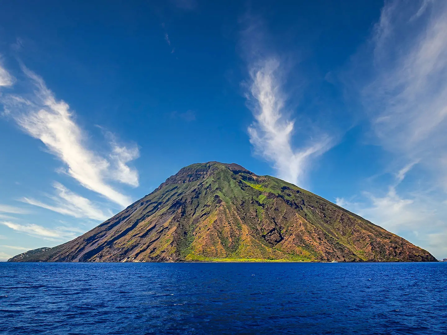
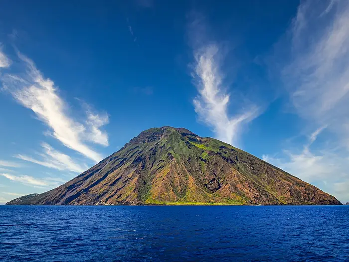
Stromboli and the Sciara del Fuoco: Stromboli is one of the world’s most continuously active volcanoes, often called the “Lighthouse of the Mediterranean”. From permitted lower viewpoints, hikers can watch glowing eruptions and the Stream of Fire lava channel after dark.
Monte Fossa delle Felci, Salina (962 m): The highest point in the Aeolian archipelago is an extinct cratered volcano inside the Montagne delle Felci e dei Porri nature reserve. The climb passes greener terrain with ferns, chestnut and holm-oak.
Vulcano — Gran Cratere La Fossa: This still-steaming sulphur crater has a regulated walking route to the rim. The fumarole landscape contrasts with Vulcano’s black-sand beach and natural mud baths below.
Lipari town and castle: Lipari is the largest and liveliest island. Its clifftop castle houses the Aeolian Archaeological Museum, with collections tied to the islands’ long obsidian-trade history.
Salina’s vineyards and villages: Salina is the greenest of the islands, with Malvasia vines and caper fields around Santa Marina, Malfa and Valdichiesa. It is a strong contrast to the harsher ash slopes of Stromboli and Vulcano.
Ginostra: This small, road-free hamlet on Stromboli is reached only by sea or on foot. Its whitewashed houses and tiny harbour give a quieter view of island life.
Challenges to expect
Expect steep volcanic ascents on loose scree, ash and gravel, especially on Stromboli, Vulcano and Salina. Shade and water are limited on many paths, so spring and autumn are far better than July-August heat. Ferries are part of the route and can be suspended by wind, storms or sea conditions. Access rules also change with volcanic activity: since renewed unrest in October 2024 the Stromboli summit (924 m) has been off-limits, with unguided walkers held near 290 m and licensed guides reaching about 450 m, and an overnight stay on the island is compulsory. Vulcano's La Fossa crater has timed-entry windows, a closed fumarole side and a gas 'traffic light' that can shut the path - always check current rules locally before climbing.
HikeList Score
Aeolian Islands Trek scored 88/100 on HikeList's trail-quality metrics.
See score breakdownHide breakdown
- Ideal length 85
- Balanced challenge 84
- Scenery & wildness 98
- Varied terrain 89
- Accommodation 91
- Food & support 74
- Path quality 98
- Season flexibility 76
Computed from length, challenge, scenery & wildness, terrain variety, accommodation, food & support, path quality and season flexibility.
 Italy
ItalyShow more data Show less
- Mountainous
- Coastal
- Forest
- Dirt
- Rocky
- Gravel
- Ash
- Hotels
- Guesthouses
- Hostels
- Pet Friendly
- Restrooms
- Water Sources
Download Our Full Guide to Aeolian Islands Trek FREE!
Get our comprehensive guide to this hike for free. Save it for later reading or print out at home.
In these collections
Photos from hikers
Taken on the trail by people who've reviewed Aeolian Islands Trek.
Aeolian Islands Trek: The Complete Guide
 i
Image by Martin M303
i
Image by Martin M303 The Aeolian Islands Trek is a compact but serious volcanic walking itinerary linking Vulcano, Lipari, Salina and Stromboli by public ferry and hydrofoil. It suits experienced walkers who want steep island day-walks, active volcanoes and village-based logistics rather than a continuous waymarked trail.
The route begins with the steaming Gran Cratere della Fossa above Vulcano Porto, then moves through Lipari’s coastal tracks, quarries and island towns. Salina gives the highest walking of the trek on Monte Fossa delle Felci, a 962 m extinct volcano and the high point of the whole archipelago.
Stromboli is the dramatic finish, with permitted lower viewpoints towards the Sciara del Fuoco rather than the summit itself. Current access rules keep unguided walkers to lower levels, guided groups higher but still below the top, and an overnight stay on the island is compulsory.
What this trek asks of you is planning as much as fitness. Expect loose ash, scree and gravel, limited shade and water, ferry timetables shaped by wind and sea state, and volcano rules on Vulcano and Stromboli that must be checked locally before setting out.
This guide covers stages, days, accommodation, food, transport, terrain and the common mistakes that disrupt an Aeolian Islands walking itinerary.
Stage-by-Stage Guide
Stage 1: Vulcano Porto to Gran Cratere della Fossa and back
The opening stage is a short but sharp volcanic climb from Vulcano Porto, usually starting near Porto di Levante / Porto di Ponente and rising to the rim of the Gran Cratere della Fossa. Do not underestimate the distance: the work comes from the heat, the exposed slope and the loose volcanic surface rather than from the mileage.
Underfoot, expect dusty ash, lapilli, gravel and loose scree, with little natural shade once above the village. The crater route is regulated, and walkers must stay on the permitted line around the rim; the fumarole side is closed and should not be entered.
The main landmark is the crater itself: a sulphur-stained rim with active fumaroles, yellow deposits and views back over Vulcano’s black-sand beach, the harbour area and the surrounding islands. The path is straightforward in clear weather, but mist, strong wind or poor visibility can make the rim feel more serious than the map distance suggests.
Food and water should be bought in Vulcano Porto before setting out. There is no reliable drinking water on the crater climb, and the exposed ash slope is punishing in warm weather, so carry more than would normally be needed for a 6 km walk.
Accommodation is available in and around Vulcano Porto in hotels, guesthouses, B&Bs, pensioni, affittacamere and hostels, though many island businesses reduce opening or close in winter. The stage also works as a day walk after arriving by hydrofoil from Milazzo, which is about 20 minutes away by hydrofoil in normal conditions.
The key planning issue is access. The Gran Cratere della Fossa has timed-entry windows, is closed during the hottest midday hours in the warmer season, and can be shut by the gas “traffic light” system. Current opening times, permitted areas and gas restrictions must be checked locally before setting out.
Stage 2: Lipari town circuit via Monte Guardia, the west-coast quarries and Quattropani
This is the most flexible stage of the trek: a circuit or linked day walk from Lipari town using old mule tracks, minor roads and rocky coastal paths. The usual interest lies in combining the historic centre around Lipari castle with higher ground such as Monte Guardia and the west-coast quarry landscapes around Acquacalda / Quattropani.
Terrain is mixed rather than technically difficult, but it can still be tiring. Expect rocky paths, gravelly tracks, dry exposed slopes and some road or lane walking between settlements and viewpoints. In hot weather this can feel harder than the approximate 12 km suggests, especially where there is little shade.
Lipari town is the largest settlement on the trek and the best place to stock up, eat and organise onward ferries. Marina Corta, Marina Lunga, the clifftop castle and the Aeolian Archaeological Museum can be fitted around the walking day, while Canneto, Acquacalda and Quattropani give access to the island’s pumice and kaolin quarry scenery.
The quarry coast is the stage highlight: pale pumice and kaolin scars contrast strongly with the darker volcanic rock elsewhere in the archipelago. Views open across the sea to neighbouring islands, but the exact line and viewpoints depend on the circuit chosen.
Carry a full day’s water from Lipari town unless the day has been planned around open village services. Canneto, Acquacalda and Quattropani are useful names for planning, but opening hours and seasonal availability vary, so food and water should not be assumed away from Lipari town.
Accommodation is easiest in Lipari town, with a broad choice of village-based hotels, guesthouses and rooms. Lipari is also a practical ferry base, with inter-island hydrofoils and ferries operated by companies such as Liberty Lines and Siremar / Caronte & Tourist.
Navigation needs more attention here than on the crater out-and-backs. This is not a single official waymarked long-distance trail, and the Lipari day can be put together in several ways, so use a reliable map or GPS track and check that any intended route is still passable before leaving town.
Stage 3: Salina — Santa Marina or Valdichiesa to Monte Fossa delle Felci and back
The Salina stage climbs to Monte Fossa delle Felci, the 962 m high point of the Aeolian Islands and the highest point of the whole trek. It is a proper mountain day by island standards, with sustained ascent, a summit inside the Riserva Naturale Le Montagne delle Felci e dei Porri, and a noticeably greener feel than Vulcano or Stromboli.
The walk can begin from Santa Marina di Salina or higher inland around Valdichiesa and the Santuario della Madonna del Terzito, depending on where accommodation and transfers are arranged. Starting higher shortens the climb; starting on the coast gives the fuller ascent and a harder day.
Underfoot, Salina is less ashy than the active-volcano stages, but the paths can still be steep, uneven and slippery when wet. The upper slopes are known for ferns, chestnut and holm-oak, and the old cratered terrain gives the stage a more wooded, enclosed character before the broader summit views.
The summit panorama is the reason to make the climb. In settled weather there are wide views across the archipelago, with the contrast between Salina’s green slopes, the surrounding sea and the other volcanic islands particularly strong.
Food and water should be sorted before leaving Santa Marina, Malfa, Valdichiesa or another base. Do not rely on finding water on the mountain, and carry enough for the full ascent and descent, especially in late spring, early autumn or any unseasonably hot spell.
Accommodation can be based in Santa Marina di Salina, Malfa, Rinella or nearby villages such as Leni, depending on the next ferry connection. Salina is linked into the inter-island ferry and hydrofoil network, but timings affect the next day’s move towards Stromboli and should be checked before travelling.
Navigation is generally more contained than on Lipari because the objective is clear, but cloud on the summit and forested sections can still make wayfinding awkward. A downloaded map or GPS route is sensible, and an early start is preferable in warm weather.
Stage 4: Salina coast or Lipari to Stromboli; Sciara del Fuoco viewpoint walk
This stage is split between logistics and walking: first a ferry or hydrofoil connection from Salina or Lipari to Stromboli, then an evening or late-day walk to the permitted lower viewpoints towards the Sciara del Fuoco. It is one of the defining days of the itinerary, but it depends heavily on ferry times, sea conditions and current volcano-access rules.
The walking from Stromboli village is shorter than a summit ascent but still steep, dry and exposed. Paths use loose volcanic gravel and ash on the lower flanks of the volcano, and footing can be dusty in dry weather and slippery after rain.
The main places are Stromboli village, including San Vincenzo / San Bartolo and the Scari harbour area, and the viewpoint approaches around Punta Labronzo or the San Vincenzo path. The reward is the Sciara del Fuoco — the great lava and debris chute on the volcano’s flank — best appreciated when conditions and regulations allow viewing after dark.
Carry water from Stromboli village. There should be no expectation of water on the viewpoint paths, and the combination of black volcanic ground, wind and heat can dehydrate walkers quickly.
An overnight on Stromboli is compulsory under current rules, so accommodation in Stromboli village should be booked before relying on this stage. Options include hotels, guesthouses, B&Bs, pensioni, affittacamere and hostels, with spring and autumn demand requiring advance booking.
The summit of Stromboli is off-limits under the current post-October 2024 restrictions. Unguided walkers are held near about 290 m, licensed guides can reach about 450 m, and fines apply for breaches; limits change with volcanic alert level and must be checked locally before walking.
Public transport for the day is by ferry or hydrofoil, typically with Liberty Lines hydrofoils and Siremar / Caronte & Tourist ferries. Wind and sea state can cancel or delay crossings, so this stage should not be scheduled on a tight onward connection.
Stage 5: Stromboli village to lower volcano viewpoints and / or Ginostra
The final walking day remains on Stromboli and should be planned around the access rules in force at the time. Most hikers combine lower volcano viewpoints with either additional walking from Stromboli village or a visit to Ginostra, the road-free hamlet on the southern side of the island.
Terrain stays volcanic and exposed: loose ash, gravel, rough tracks and hot, dry surfaces are the norm. The approximate 14 km distance can feel demanding because escape options are limited and shade and water are scarce away from the settlements.
From Stromboli village, the key landmark remains the lower flank of the active volcano and the permitted viewpoints towards the Sciara del Fuoco. Ginostra is a separate highlight: a tiny road-free hamlet reached only by sea or on foot, with no road link back to Stromboli village.
Food and water must be organised before leaving Stromboli village. If Ginostra is included, do not assume flexible services, and plan conservatively for the full day’s water, snacks and return logistics.
Accommodation at the end is normally again in Stromboli village unless a specific stay in Ginostra has been arranged. Availability is seasonal, and accommodation should be tied carefully to ferry plans because bad weather can disrupt departures from the island.
Public transport is limited to sea connections. If using a boat to or from Ginostra, timings and operating conditions should be checked locally before committing to the walk, as the hamlet is reached only by sea or on foot.
Navigation should be treated seriously despite the island’s compact size. Stay within the permitted volcano-access zones, do not attempt the closed summit, and avoid starting any exposed return section late unless the route, light, weather and local regulations are all clear.
Recommended Itinerary
Standard 5-day itinerary
This is the most practical core itinerary for experienced walkers: one main walking day on each of Vulcano, Lipari and Salina, then two days based around Stromboli. It keeps the route moving eastwards while recognising that ferries, hydrofoils and volcano access rules are part of the planning, not an afterthought.
| Day | From | To | Approx. distance | Why this stage makes sense | Services/accommodation notes |
|---|---|---|---|---|---|
| 1 | Vulcano — Porto di Levante | Gran Cratere della Fossa rim and back | 6 km | A short but steep opening day gives time to reach Vulcano from Milazzo, climb the regulated crater route and move on only if ferry timings allow. The crater is best treated as a serious volcanic ascent despite the modest distance: loose ground, fumes, heat and closures can all affect the day. | Stay in Vulcano Porto or continue by ferry/hydrofoil to Lipari if timings and sea conditions are favourable. The Gran Cratere has timed-entry windows, summer midday closures and a gas “traffic light” system that can shut the path; check locally before starting. |
| 2 | Lipari town | Lipari circuit via Monte Guardia / west-coast quarries / Quattropani | 12 km | Lipari is the logistical centre of the islands, so it works well as the first full island-walking day. The stage combines village access with exposed coastal and quarry landscapes, including the pumice and kaolin areas around Acquacalda / Quattropani depending on the chosen line. | Lipari town has the broadest choice of accommodation and services, especially around Marina Corta and Marina Lunga. Carry enough water before leaving town, as shade and reliable water on the walking routes are limited. |
| 3 | Salina — Santa Marina di Salina or Valdichiesa | Monte Fossa delle Felci and back | 10 km | This is the highest day of the trek, reaching Monte Fossa delle Felci at 962 m, the high point of the whole Aeolian archipelago. Starting from Santa Marina di Salina or Valdichiesa keeps the day focused on the climb and descent rather than ferry logistics. | Stay in Santa Marina di Salina, Malfa, Rinella or nearby villages, depending on ferry arrival and onward plans. Salina is greener than the other islands, but the climb still needs an early start in warm weather and enough water for the full ascent and descent. |
| 4 | Salina coast / Lipari | Ferry to Stromboli; Sciara del Fuoco viewpoint walk | 9 km | This day builds in the essential transfer to Stromboli and leaves time for the lower viewpoint walk towards the Sciara del Fuoco. Walking later in the day can be useful for seeing activity after dark, but only within the permitted access limits. | An overnight on Stromboli is compulsory under current rules. Stay in Stromboli village around San Vincenzo / San Bartolo, near Scari harbour. Since renewed volcanic unrest in October 2024, the summit is off-limits; unguided walkers are held near about 290 m and licensed guides reach about 450 m. Check the current Civil Protection alert level and local rules before setting out. |
| 5 | Stromboli village | Lower volcano viewpoints / Ginostra option | 14 km | A second day on Stromboli avoids treating the island as a rushed add-on and gives a better chance of fitting walking around ferry times, heat and access restrictions. The day can focus on permitted lower volcano viewpoints, or include Ginostra by sea or on foot where conditions and logistics suit. | Stay a second night on Stromboli if ferry connections are uncertain, or depart only after allowing for delays caused by wind or sea state. Ginostra is road-free and reached only by sea or on foot, so onward timing should be checked before committing to this option. |
Slower variant: 6–7 days
A slower plan suits walkers travelling in spring or autumn who want more resilience against ferry disruption, hot weather or volcano-access changes. It is also the better choice if accommodation is split between several villages rather than concentrated in Lipari and Stromboli.
The simplest slower version is to add one buffer night on Lipari or Salina, then one extra night on Stromboli. This gives more room to move the Salina high-point day if cloud, heat or ferry delays interfere, and it reduces the risk of missing the Stromboli viewpoint walk because of a late crossing.
Do not treat the extra time as optional if onward travel from Milazzo, Catania or Palermo is tightly booked. Bad weather can suspend ferries and hydrofoils, especially outside the main summer season, and winter schedules are reduced with more island closures.
Faster variant: 4 days
A 4-day version is only sensible for fit, experienced walkers in settled weather with flexible ferry timings already checked. It usually means combining a crater walk with a transfer day, or compressing Lipari and Salina logistics, rather than shortening the volcanic ascents themselves.
This faster version is poorly suited to July–August heat, first-time visitors to the islands, or anyone with fixed onward travel. It must still respect the compulsory overnight on Stromboli and the current Stromboli access limits; the summit is not part of this trek.
Distances for any compressed version vary by ferry choice, start point and the exact island routes selected. Check official mapping before booking, and verify Liberty Lines and Caronte & Tourist / Siremar crossings before relying on a same-day connection.
Planning the Route
The Aeolian Islands Trek needs to be planned as a linked sequence of island day-walks, not as a continuous trail. The walking itself is straightforward to divide, but the overall itinerary is controlled by ferry times, volcano access rules and where accommodation is available each night.
Five days is the efficient core schedule for Vulcano, Lipari, Salina and Stromboli. Most independent walkers should allow extra time beyond that, especially if onward travel from Stromboli or a specific flight connection depends on a ferry running to plan.
How many days to allow
A five-day itinerary works if ferries run on schedule, accommodation is pre-booked, and the volcano access rules allow the intended walks. It is a tight plan rather than a relaxed one, because bad weather can delay crossings and Stromboli currently requires an overnight stay.
A slower six- or seven-day plan is more robust. Extra time is best used on Lipari or Salina, where there are several village bases and route variations, or as a buffer before or after Stromboli.
| Itinerary length | Best for | Main trade-off |
|---|---|---|
| 5 days | Walkers with fixed dates who want the four-island core | Little margin for ferry disruption or altered volcano access |
| 6–7 days | Most independent walkers | More accommodation nights, but far better resilience |
| Longer | Adding rest days, extra island time or additional Aeolian islands | Requires more ferry planning and seasonal accommodation checks |
Where the stages naturally fall
The route is naturally village-based. Each island walk starts and finishes from a settlement or ferry port area, so accommodation choices largely dictate how early you can start and whether a transfer is needed to reach the trailhead.
| Island | Practical base choices | Planning notes |
|---|---|---|
| Vulcano | Vulcano Porto, around Porto di Levante / Porto di Ponente | Best planned around the Gran Cratere della Fossa access window. In summer, the crater is closed during the hottest midday hours, so an early or late walk is normally required. |
| Lipari | Lipari town, around Marina Corta / Marina Lunga | The easiest island for logistics, with ferry links and access to the Lipari circuit options including Monte Guardia, the west-coast quarry area and Quattropani. |
| Salina | Santa Marina di Salina, Malfa, Rinella, Leni or Valdichiesa | Choose the base to suit the intended Monte Fossa delle Felci route. The 962 m summit is the high point of the trek, so an early start and enough water matter. |
| Stromboli | Stromboli village, around San Vincenzo / San Bartolo near Scari harbour | An overnight stay is compulsory under current rules. Plan the Sciara del Fuoco viewpoints for the permitted access level and check conditions locally before setting out. |
Walking quickly versus walking slowly
This is not a route that rewards rushing. The daily distances are not long, but the steep volcanic ground, heat, loose surfaces and ferry dependency make a compressed schedule more fragile than it looks on paper.
Walking more slowly gives useful flexibility: an early morning ascent of Vulcano before the heat, a full day for Monte Fossa delle Felci on Salina, and an evening on Stromboli when the Sciara del Fuoco viewpoints are at their most worthwhile. It also reduces the risk of missing a ferry because a dusty descent took longer than expected.
Shortening, extending and section hiking
Shortening is simple in principle because each island walk is separate. If time is limited, one island can be omitted, or a lower-level walk can replace a summit or crater route when heat, wind or access rules make the planned ascent unsuitable.
Extending is also straightforward, but should be planned around ferry timetables rather than walking ambition alone. Extra nights on Lipari or Salina are usually the most practical way to add flexibility within the core route; some longer Aeolian walking itineraries also add other islands, but ferry schedules and accommodation availability must be checked before travelling.
Section hiking is practical. Vulcano, Lipari, Salina and Stromboli can each be walked as a separate short trip, provided the ferry connections work for the chosen dates. Stromboli is the least convenient for a day-only approach because the current rules require an overnight stay on the island.
Transport planning matters as much as the walking
Milazzo is the main gateway port for the islands, with hydrofoils and ferries to the Aeolian Islands. Vulcano is the closest island to the Sicilian mainland, and the overall route then works eastwards through Lipari and Salina to Stromboli.
Inter-island travel is by Liberty Lines hydrofoils and Siremar / Caronte & Tourist ferries. These services can be delayed or cancelled by wind and sea state, so avoid planning critical travel connections immediately after a crossing, especially from Stromboli.
Ferry times, ticket rules and seasonal frequencies should be checked before travelling. Winter has reduced services and more accommodation closures, while spring and autumn are generally better for walking conditions.
Accommodation strategy
Book accommodation ahead in spring and autumn, and especially if the route includes Stromboli on fixed dates. The islands are village-based rather than hut-based, with hotels, guesthouses, B&Bs, pensioni, affittacamere and some hostels in the main settlements.
There is no need to carry camping equipment for the standard itinerary. The key decision is not where to sleep on the trail, but which village gives the best start for the next day’s walk and the next ferry crossing.
On Salina, base choice affects the Monte Fossa delle Felci day more than on the other islands. Santa Marina di Salina, Malfa, Rinella, Leni and Valdichiesa all sit differently in relation to the high ground, so the chosen route and return plan should be matched to the accommodation.
Food and water
Food planning is simple in the villages and ports, but water planning is critical on the trail. The crater climbs and exposed coastal paths have little shade and scarce drinking water, so carry what is needed for the full walk before leaving the settlement.
Do not rely on finding water on the climbs to Gran Cratere della Fossa, Monte Fossa delle Felci or the Stromboli viewpoints. In hot weather, start early, carry more than a minimal bottle, and treat the descents on loose ash and gravel as part of the day’s effort rather than an easy finish.
Navigation and route choice
Navigation is usually about selecting the correct local path or circuit on each island rather than following a single long-distance waymark. A downloaded map, offline route notes and enough battery are sensible, particularly on Lipari’s quarry and west-coast options and on Salina’s higher wooded slopes.
Expect surfaces to change quickly. Dry ash and lapilli can be dusty and unstable; wet volcanic gravel and rock can become slippery. Walking poles are useful for the steep descents if normally used, but route planning should assume slower progress than the distance alone suggests.
Volcano access checks
Volcano access is the main planning variable on this trek. Stromboli’s 924 m summit has been off-limits since renewed unrest in October 2024; unguided walkers are held to around 290 m, licensed guides reach about 450 m, and fines apply for breaches. Conditions change with the alert level, so the current limits must be checked locally before walking.
Vulcano’s Gran Cratere della Fossa also has controlled access. The route has timed-entry windows, summer midday closures during the hottest part of the day, a closed fumarole side and a gas “traffic light” system that can shut the path. This should be checked before travelling and again on the island.
These restrictions do not make the trek unworkable, but they do mean the plan must be flexible. Build the itinerary around permitted viewpoints and safe access, not around an assumed summit objective.
Towns, Villages and Overnight Stops
The Aeolian Islands Trek is best planned around village bases rather than remote trail accommodation. Each walking day starts from a port town or island village, with ferries and hydrofoils acting as part of the route.
Accommodation is seasonal. Hotels, B&Bs, pensioni, affittacamere and some hostels are found in the main island settlements, but many places close in winter and availability tightens in spring, autumn and especially summer. Book ahead, and keep ferry disruption in mind when choosing non-refundable stays.
Milazzo
Milazzo is the practical mainland gateway for the trek. It sits on the north coast of Sicily and is the main departure port for hydrofoils and ferries to the Isole Eolie.
Most walkers use Milazzo as a transit stop rather than part of the walking itinerary. It is particularly useful if arriving late from Catania, Palermo or elsewhere in Sicily, or if an early crossing to Vulcano is needed the next morning.
Hydrofoils and ferries run from Milazzo to the islands, with Vulcano about 20 minutes away by hydrofoil in normal conditions. Liberty Lines hydrofoils and Siremar / Caronte & Tourist ferries serve the inter-island network, but timetables and weather disruption should be checked before travelling.
Vulcano — Porto di Levante / Porto di Ponente
Vulcano Porto is the usual first island base, close to both Porto di Levante and Porto di Ponente. The Gran Cratere della Fossa walk starts above this port area, so it is the most convenient place to stay before or after the crater climb.
Accommodation is available in the village-based style typical of the trek: hotels, guesthouses and similar small lodgings. Food, cafés and basic visitor services are concentrated around the port area, making this the sensible place to stock up before walking.
Vulcano is close enough to Milazzo for some itineraries to visit as a first-day crossing, but staying overnight removes pressure from ferry delays and crater access windows. The Gran Cratere has timed-entry restrictions during the hotter months, a closed fumarole side and a gas traffic-light system that can shut the route; current access must be checked locally before committing to the climb.
Gran Cratere della Fossa
The Gran Cratere is a walking objective rather than an overnight stop. The route is normally done as an out-and-back from Vulcano Porto, returning to the same village for accommodation, food and onward transport.
There are no reliable trail services on the crater route, and shade and water are limited. Carry water from Vulcano Porto and avoid assuming that access will be available at any time of day, particularly from April to October when the route can be closed during the hottest midday hours.
Vulcano Piano / Capo Grillo
Vulcano Piano and Capo Grillo sit inland and uphill from the port area and may feature in longer Vulcano walking options. They are useful for extending the island day beyond the Gran Cratere, but they are not the standard overnight base for this trek.
Use Vulcano Porto for accommodation and ferry logistics unless specific lodging has been arranged elsewhere on the island. Services away from the port should be treated as limited and seasonal; this should be checked before travelling.
Lipari town — Marina Corta / Marina Lunga
Lipari town is the main base for the Lipari stage and one of the most useful overnight stops on the whole itinerary. The walking options around Monte Guardia, the west-coast quarries and Quattropani can be reached from here, and the town also gives the best flexibility for ferries onward to Salina or Stromboli.
Accommodation is available in the main town, including village-style hotels, guesthouses, B&Bs and similar lodgings. Food, cafés and shops are most reliably found here compared with the smaller settlements on the island.
The harbour areas around Marina Corta and Marina Lunga are important for ferry and hydrofoil movements, so staying within easy reach of the waterfront simplifies early departures. Lipari is also a good contingency base if weather delays an inter-island crossing, as it has more services than the smaller villages.
Lipari castle and the Aeolian Archaeological Museum
Lipari castle and the Museo Archeologico Eoliano are in Lipari town rather than a separate overnight stop. They are useful to fit around ferry times, rest time or a shorter walking day.
For hikers, the practical value is location: the castle area is close to the main town services and can be visited without moving accommodation. It is also a good wet-weather or ferry-delay option if sea conditions interrupt the itinerary.
Canneto
Canneto is a Lipari coastal settlement that may be passed or used on route variations around the island. It can be useful as a secondary stop during the Lipari day, but Lipari town remains the stronger base for accommodation and ferries.
Expect more limited services than in Lipari town, especially outside the main season. If planning to start, finish or resupply here rather than in Lipari town, current opening times and local transport options should be checked before travelling.
Acquacalda / Quattropani
Acquacalda and Quattropani sit on or near the northern and western Lipari walking options, close to the pumice and kaolin quarry landscapes. They are useful landmarks for the Lipari circuit rather than default overnight stops.
These areas are best treated as daytime walking objectives from Lipari town unless accommodation has been booked in advance. Carry enough water and food for the full walking section, as services away from the main town can be sparse or seasonal.
Salina — Santa Marina di Salina
Santa Marina di Salina is one of the main Salina bases and a practical overnight stop for the Monte Fossa delle Felci stage. It is suitable for walkers arriving by ferry or hydrofoil and wanting a straightforward village base before tackling the island high point.
Accommodation is available in Santa Marina di Salina as part of the trek’s village-based lodging network. Food and cafés are found in the settlement, but opening patterns can be seasonal, so do not rely on late or out-of-season services without checking.
Santa Marina works well if the next walking day starts from the coast or if ferry logistics are the priority. The climb to Monte Fossa delle Felci is the highest point of the whole archipelago at 962 m, so staying here the night before gives time to start early and avoid the worst heat.
Malfa
Malfa is another useful Salina base, especially for walkers wanting to stay on the greener, vineyard-and-village side of the island rather than simply pass through. It is a realistic overnight option within the Salina section, with village accommodation available on the island.
Food and cafés should be expected in the village, but service levels vary by season. As on the rest of the islands, water for the walking day should be carried from the village rather than expected on the trail.
Malfa is a good choice if the itinerary allows a slower Salina day or if accommodation in Santa Marina is limited. It also gives access to the quieter village character of Salina, away from the most ferry-focused logistics.
Valdichiesa / Santuario della Madonna del Terzito
Valdichiesa and the Santuario della Madonna del Terzito sit around the saddle area used for approaches to Monte Fossa delle Felci. They are important walking points on Salina rather than the main accommodation hubs.
Some walkers start the summit day from Santa Marina or Valdichiesa, depending on the chosen route and transfer arrangements. If planning to base here or arrange transport to the saddle, details should be checked before travelling.
Do not assume full resupply at Valdichiesa. Carry food and water from the overnight village, especially for the ascent of Monte Fossa delle Felci, where the route climbs into the Riserva Naturale Le Montagne delle Felci e dei Porri.
Monte Fossa delle Felci
Monte Fossa delle Felci is the high point of the trek and the highest summit in the Aeolian archipelago at 962 m. It is not an overnight stop; walkers return to a Salina village base such as Santa Marina di Salina, Malfa, Rinella or Leni depending on the chosen route.
There are no practical trail services on the summit climb. The mountain is greener than Vulcano or Stromboli, with forested and cratered slopes, but it is still a serious ascent in heat and should be approached with enough water, sun protection and time for the descent.
Rinella / Leni
Rinella and Leni on Salina’s south side can work as overnight bases if they fit the ferry plan or the chosen Monte Fossa delle Felci route. They are particularly useful for walkers who want to finish the Salina stage on the south coast rather than return to Santa Marina.
Accommodation is available on Salina in villages including Rinella and Leni, but choice and opening periods should be checked before booking the wider itinerary. Food and café options are more limited than in larger island centres, so plan the next day’s supplies in advance.
These villages can be useful before moving onward by sea, but the exact ferry suitability depends on current timetables and sea conditions. This should be checked before travelling.
Stromboli village — San Vincenzo / San Bartolo and Scari harbour
Stromboli village is the compulsory overnight stop for the Stromboli section under current access rules. The main settlement areas of San Vincenzo and San Bartolo sit below the volcano, with Scari harbour providing the ferry and hydrofoil arrival point.
Accommodation is available in the village, but it should be booked well ahead in spring, autumn and summer. Food, cafés and basic supplies are concentrated in the village, and this is the place to organise water, evening plans and any guided access permitted under current volcano rules.
Stromboli is the least flexible island for last-minute planning because the volcano access rules are strict and crossings can be affected by wind and sea state. Since renewed volcanic unrest in October 2024, the 924 m summit is off-limits; unguided walkers are held near about 290 m and licensed guides reach about 450 m. Current limits, guide requirements and the compulsory overnight rule must be verified locally before walking.
Sciara del Fuoco viewpoints — Punta Labronzo / San Vincenzo path
The Sciara del Fuoco viewpoints are walking objectives from Stromboli village rather than separate overnight stops. They are used to view the volcano’s active slope and are often best planned around the permitted evening access window and the return to accommodation in the village.
There are no reliable services at the viewpoints. Carry a headtorch, warm layer for waiting after dark, and enough water, then return to Stromboli village for food and accommodation.
Access is controlled by the volcano alert level and may change quickly. Do not assume that older route descriptions to the summit are valid; current local rules take priority.
Ginostra
Ginostra is a small road-free hamlet on Stromboli, reached only by sea or on foot. It is an atmospheric outlier for walkers with extra time, but it is less convenient than Stromboli village for ferry flexibility, services and volcano-access logistics.
Any overnight plan in Ginostra needs careful checking in advance. Accommodation, food and transport options are more limited and dependent on sea access, so it is not the simplest base for a first Aeolian Islands itinerary.
Ginostra is best treated as an optional extension from the Stromboli stage rather than a guaranteed finish point. If sea conditions or timetables change, returning to or from the hamlet can become difficult, so build in buffer time and check current boat options before committing.
Getting to the Start
The usual start point for the Aeolian Islands Trek is Vulcano, reached by public hydrofoil or ferry from Milazzo on the north coast of Sicily. Most walkers arrive at Vulcano Porto, beside Porto di Levante / Porto di Ponente, then begin the Gran Cratere della Fossa walk from there.
Milazzo is the main mainland gateway. Vulcano is the closest Aeolian island to Sicily, with the hydrofoil crossing from Milazzo taking about 20 minutes in normal conditions.
Ferry and hydrofoil timetables are a core part of the route planning. Services can be delayed or cancelled by wind and sea state, so do not plan a tight same-day connection between an airport, the Milazzo port and the first walk on Vulcano.
By train
The practical rail approach is to travel to Milazzo on the Sicilian mainland, then continue to the port for the hydrofoil or ferry to Vulcano. The onward transfer between the railway station and the harbour should be checked before travelling, especially if arriving early, late or outside the main season.
From Milazzo port, use the Aeolian Islands services operated by companies such as Liberty Lines for hydrofoils and Siremar / Caronte & Tourist for ferries. Check the current timetable before booking accommodation on Vulcano, as weather and seasonal schedules can affect the final crossing.
By bus
Bus or coach access is mainly relevant for reaching Milazzo from elsewhere in Sicily, including airport transfers. Exact operators, timings and seasonal frequency vary, so this should be checked before travelling.
If a bus connection does not align with the ferry departure, allow time for a taxi or private transfer to the port. This is particularly important if trying to reach Vulcano on the same day as an international flight.
By car
Drivers should normally aim for Milazzo and then continue to Vulcano by hydrofoil or ferry. Although car ferries serve the Aeolian Islands, this trek is designed as an island-hopping walking itinerary, and taking a vehicle across the islands is usually an unnecessary complication.
If leaving a car on the mainland, look for long-stay parking in or near Milazzo port and book ahead in busy periods. Parking arrangements, security, prices and opening hours should be checked before travelling.
Remember that the trek finishes on Stromboli, not back at Milazzo. Anyone leaving a car in Milazzo must plan the return ferry or hydrofoil connection from Stromboli, allowing buffer time for possible weather disruption.
From the nearest airport
There are no airports on the Aeolian Islands. The nearest practical airport gateways are Catania and Palermo, followed by an overland transfer to Milazzo and then a hydrofoil or ferry to Vulcano.
Some Aeolian services also operate from Messina, Palermo, Reggio Calabria and, seasonally, Naples, but Milazzo remains the main and usually simplest gateway for starting on Vulcano. Current routes and seasonal departures should be checked before travelling.
For smoother logistics, avoid planning to land in Sicily and climb the Gran Cratere on the same day unless the flight, transfer and ferry timings leave a generous margin. A late flight or a cancelled crossing can easily push the start back by a day.
Where to stay before starting
The most convenient pre-start base is Vulcano Porto, close to Porto di Levante / Porto di Ponente and the start of the Gran Cratere della Fossa walk. This keeps the first walking day simple and avoids depending on a morning ferry from the mainland.
If arriving in Sicily late in the day, Milazzo is the safer overnight stop before taking an early hydrofoil or ferry to Vulcano. This also gives useful flexibility if sea conditions disrupt the island crossings.
Accommodation on the islands is village-based, with hotels, guesthouses, B&Bs, pensioni, affittacamere and some hostels. Book well ahead in spring and autumn, and be cautious with winter plans, when ferry schedules reduce and many places close.
Getting Home from the Finish
The trek finishes on Stromboli, usually in Stromboli village around San Vincenzo / San Bartolo, with departures from Scari harbour. There is no airport or railway on the island, so every onward journey starts with a ferry or hydrofoil.
Plan the journey home with a buffer. Crossings can be delayed or cancelled by wind and sea conditions, and a late finish after an evening Sciara del Fuoco viewpoint walk often makes an overnight stay on Stromboli the practical option.
By train
There are no trains on Stromboli or anywhere in the Isole Eolie. Rail travel only becomes relevant once you have crossed back to the mainland, normally via Milazzo, the main Sicilian gateway port for the islands.
From Stromboli, use Liberty Lines hydrofoils or Siremar / Caronte & Tourist ferries to reach Milazzo or another served mainland port. The onward link between the port and railway services is timetable-dependent and should be checked before travelling, especially if connecting to a same-day train.
If a long rail journey is planned, avoid relying on the final ferry of the day. A missed connection caused by sea conditions can easily affect onward travel across Sicily or mainland Italy.
By bus
There is no bus-only exit from Stromboli: the sea crossing comes first. After reaching Milazzo, Messina, Palermo, Reggio Calabria or another mainland port served by your chosen ferry, onward buses or transfers may be available to larger towns, railway stations and airports.
Current bus links, departure points and connection times should be checked before travelling. This is particularly important outside the main spring–autumn season, when ferry services are reduced and many island services operate less frequently.
By car/taxi
Most walkers do not need a car for this trek, because the route is built around village stays and public ferry or hydrofoil crossings. If a car has been left on the Sicilian mainland, the simplest return is usually to take a ferry or hydrofoil from Stromboli back towards Milazzo.
Taxis may be useful after the mainland crossing for the port-to-station or port-to-airport transfer, but availability, cost and journey time are not fixed. This should be checked before travelling, and pre-booking is sensible when connecting with a flight or late train.
Ginostra, if used as part of the final day, is road-free and reached only by sea or on foot. Do not plan any road transfer from there; return arrangements depend on boat services or walking back within the limits of the day’s itinerary.
From the nearest airport
The nearest practical airports for the Aeolian Islands are Catania and Palermo, followed by a transfer to or from Milazzo. At the end of the trek, allow time for three separate legs: Stromboli to the mainland by ferry or hydrofoil, the mainland transfer, then the flight.
Some services also operate from or to Messina, Palermo, Reggio Calabria and seasonally Naples, which may suit certain onward plans better than returning through Milazzo. Routes and frequency vary by season, operator and sea conditions, so check Liberty Lines and Siremar / Caronte & Tourist timetables before booking fixed onward travel.
For morning flights, staying on the mainland the night before is usually safer than attempting to leave Stromboli and fly the same day. For afternoon or evening flights, the same-day option may work only if the ferry timetable, weather forecast and transfer timings all line up.
Where to stay at the finish
An overnight on Stromboli is compulsory under current volcano-access rules, so accommodation at the finish should be treated as part of the trek rather than an optional extra. Most walkers stay in Stromboli village, around San Vincenzo / San Bartolo, within reach of Scari harbour.
Staying the final night on Stromboli also gives more flexibility for the Sciara del Fuoco viewpoints, which are often best visited late in the day. It avoids the pressure of trying to combine a volcano walk, dinner, packing and the last boat connection.
In spring and autumn, accommodation should be booked ahead; in winter, many places close and ferry services are reduced. If onward travel is time-critical, consider adding a mainland night after Stromboli before taking a flight or long train connection.
Which Direction Should You Walk?
Standard direction: Vulcano to Stromboli
The standard and most common direction is Vulcano → Lipari → Salina → Stromboli. This matches the natural island-hopping progression from the Sicilian mainland: Vulcano is the closest Aeolian island to Milazzo, about 20 minutes by hydrofoil, so it is the simplest place to start.
This direction also gives the best build-up. The trek begins with the short, steep climb to the Gran Cratere della Fossa on Vulcano, then moves through Lipari’s village, coast and quarry landscapes, before reaching the greener high ground of Salina and the archipelago high point on Monte Fossa delle Felci. Finishing on Stromboli gives the route its strongest ending, with the permitted lower viewpoints towards the Sciara del Fuoco best appreciated after dark.
Logistically, this direction keeps the most volatile element for the end. Stromboli access rules change with volcanic activity, the summit is currently off-limits, and an overnight stay on the island is compulsory under current rules. Placing Stromboli last means any restrictions or ferry delays there are less likely to disrupt several pre-booked island stages, although onward travel still needs buffer time.
Walking it in reverse
A reverse itinerary — Stromboli → Salina → Lipari → Vulcano — is possible in principle, because this is not a continuous waymarked trail. Each island walk is a separate loop or out-and-back, and the islands are linked by public ferry or hydrofoil, so there is no physical trail reason that forces one direction.
The main drawback is logistical. Starting on Stromboli means beginning with the island most affected by volcano-access rules and the compulsory overnight requirement. If sea conditions delay ferries or local volcanic restrictions alter what is possible, the disruption can affect the rest of the itinerary.
Reverse direction also weakens the psychological finish. Vulcano’s Gran Cratere is an excellent walk, but ending there does not have the same sense of culmination as finishing below Stromboli and the Sciara del Fuoco.
Does direction change the difficulty?
Not significantly. Vulcano, Salina and Stromboli are steep whichever way the wider island sequence is walked, with loose volcanic ash, scree and gravel underfoot. Because the main walks are loops or out-and-backs rather than a continuous traverse, reversing the island order does not make the climbs meaningfully easier.
The bigger difficulty factors are heat, lack of shade, scarce water on the trails, ferry reliability and current volcano-access rules. These apply in both directions.
Weather, ferries and accommodation flow
There is no strong reason to choose direction based on wind alone. Ferries and hydrofoils can be delayed or cancelled by wind and sea state in either direction, so the practical answer is to build in buffer time, especially before fixed flights or long transfers from Sicily.
Accommodation works best when booked island by island in the standard order, with particular care for Stromboli because of the compulsory overnight. Spring and autumn accommodation should be booked well ahead, while winter brings reduced services and many closures.
Recommendation
Walk the Aeolian Islands Trek from Vulcano to Stromboli. It has the easiest start from Milazzo, the clearest accommodation and ferry flow, the best scenic progression, and by far the strongest finish. Reverse direction is workable for experienced planners with flexible bookings, but it offers no real walking advantage and makes the most sensitive logistics come first.
Accommodation Along the Route
Accommodation on the Aeolian Islands Trek is village-based rather than trail-based. Expect hotels, guesthouses, B&Bs, pensioni, affittacamere and some hostels in the main island settlements, with each day’s walk starting from or returning to a ferry-linked village.
This is not a camping or hut-to-hut route. The practical approach is to sleep in the island towns, use ferries or hydrofoils between islands, and walk with a day pack on the crater and coastal routes.
Best overnight bases
Lipari town has the strongest overall choice and is the most useful logistical base, with ferry access at Marina Corta / Marina Lunga and easy onward connections to the other islands. It works well for the Lipari circuit and can also be used as a staging point before moving on to Salina or Stromboli.
Vulcano Porto is the obvious base for the Gran Cratere della Fossa. Staying close to Porto di Levante / Porto di Ponente keeps the crater walk simple and avoids depending on an additional transfer before or after the climb.
On Salina, the main accommodation bases are Santa Marina di Salina, Malfa and Rinella. Choose the village according to ferry arrival, onward departure and how the Monte Fossa delle Felci day is being tackled; Valdichiesa is the key saddle area for the mountain route, but the main overnight choices are in the coastal villages.
Stromboli village, around San Vincenzo / San Bartolo and Scari harbour, is the key final base. An overnight on Stromboli is compulsory under current access rules, and accommodation should be booked before committing to ferry times.
| Place | Accommodation level | Best for | Notes |
|---|---|---|---|
| Milazzo | Good | Pre- or post-trek buffer night on the Sicilian mainland | Main ferry and hydrofoil gateway to the islands. Useful if building in protection against weather-delayed crossings. |
| Vulcano Porto / Porto di Levante / Porto di Ponente | Good | Gran Cratere della Fossa | The simplest base for the Vulcano crater walk. Book ahead in the main walking seasons and check current crater access windows locally. |
| Vulcano Piano / Capo Grillo | Limited | Upland Vulcano options | Not the main base for most itineraries. Accommodation and transfer practicalities should be checked before travelling. |
| Lipari town | Good | Largest accommodation choice; Lipari circuit; ferry logistics | The most flexible island base, with ferry access and a stronger range of places to stay than the smaller villages. |
| Canneto / Acquacalda / Quattropani | Limited | Specific Lipari route variants | Useful only if deliberately planning around the pumice, kaolin or west-coast sections. Transport and accommodation availability should be checked before travelling. |
| Santa Marina di Salina | Good | Salina arrival, ferry access and Monte Fossa delle Felci logistics | One of the main Salina bases. Works well if ferry timing is the priority. |
| Malfa | Good | Salina village stay and access to the island’s northern side | A practical alternative Salina base, especially for walkers wanting to stay away from the arrival port. |
| Rinella / Leni | Limited | Salina south-coast positioning | Can suit some Salina plans, but onward ferry and route logistics need checking before booking. |
| Stromboli village / San Vincenzo / San Bartolo / Scari harbour | Good but pressure-sensitive | Sciara del Fuoco viewpoints and compulsory Stromboli overnight | Book well ahead. Current rules require an overnight stay on Stromboli, and volcano access limits must be checked locally. |
| Ginostra | Limited | Deliberate extension or alternative Stromboli plan | A tiny road-free hamlet reached only by sea or on foot. Do not assume it solves Stromboli accommodation pressure; availability and access should be checked before travelling. |
Booking strategy
Book accommodation before fixing the full ferry sequence, especially for Stromboli. The route depends on public hydrofoils and ferries, but the final island has the most important accommodation constraint because the overnight is compulsory under current rules.
Spring and autumn are the best walking seasons, but that also makes them important booking periods. July and August are hotter, more crowded and less attractive for exposed volcanic walking, yet accommodation pressure can still be high.
Winter needs particular caution. Ferries are reduced, seas are rougher, and many places close, so a winter itinerary should not be planned on the assumption that every usual base will be open.
Luggage and inn-to-inn practicality
The trek works well for inn-to-inn walkers, provided it is understood as an island-hopping itinerary rather than a continuous footpath. Most walking days are loops or out-and-backs from a village, so full trekking kit does not need to be carried up the craters.
The main luggage movement is between islands by ferry or hydrofoil. A small, easily carried bag is more practical than heavy luggage, particularly when accommodation is not right beside the harbour or when crossings are delayed.
Formal luggage-transfer arrangements are not central to this route and should not be assumed. If a hotel, taxi or local operator is needed to move bags within an island, this should be checked before travelling.
Buffer nights and weather risk
Accommodation planning should include at least some tolerance for ferry disruption. Wind and sea conditions can delay or cancel crossings, and a tight sequence of one-night stays leaves little room to recover the itinerary.
A buffer night in Lipari, Salina or Milazzo can make the trip more robust. This is particularly sensible before fixed onward travel from Sicily or before the Stromboli section, where accommodation and volcano-access rules both matter.
Camping and Wild Camping
This itinerary is much better suited to village-based accommodation than camping. The walking is a series of steep day-walks linked by ferries and hydrofoils, with starts and finishes in places such as Vulcano Porto, Lipari town, Santa Marina di Salina, Malfa, Rinella and Stromboli village. Carrying camping gear adds weight on hot, loose volcanic climbs where water and shade are already limited.
Campsites and legal pitches
Do not assume there will be a convenient campsite at each stage. No fixed through-trail camping infrastructure exists for the Aeolian Islands Trek, because this is not a continuous waymarked long-distance route.
If camping is important, identify a legal campsite, authorised pitch or accommodation that explicitly accepts tents on each island before booking ferries. This should be checked before travelling, especially outside the main season, when many island services reduce or close.
The most practical camping strategy, where legal pitches are available, is to stay close to the port villages rather than high on the walking routes. That keeps ferry logistics simpler and gives access to shops, water and transport if weather delays a crossing.
Wild camping
Wild camping should not be treated as a normal option on this trek. The islands are small, inhabited and environmentally sensitive, and the route crosses volcanic access zones, coastal paths, old mule tracks and the protected Riserva Naturale Le Montagne delle Felci e dei Porri on Salina.
Rules can vary by island, municipality, protected area and volcanic alert level. Pitch only where camping is clearly permitted by the relevant local authority or landholder. This should be checked locally before relying on any wild-camping plan.
Do not camp on crater rims, fumarole areas, the flanks of Stromboli, the Sciara del Fuoco viewpoints, or inside restricted volcano zones. Stromboli access is actively regulated, with the summit off-limits under current rules, unguided walkers limited to lower elevations and an overnight stay on the island compulsory; volcano rules must be checked locally before setting out.
Water, cooking and fire risk
Plan to carry all walking water from villages and accommodation. The crater routes on Vulcano and Stromboli, the higher slopes of Salina and the exposed Lipari paths should not be relied on for drinking-water refills.
Open fires are not appropriate on this itinerary. Dry vegetation, wind, ash slopes and protected landscapes make fire risk a serious concern, particularly in summer. Stove use, where camping is legal, should follow local rules and should be checked before travelling.
Island-by-island practicality
| Island | Camping practicality |
|---|---|
| Vulcano | Best kept as a short day-walk from Vulcano Porto. The Gran Cratere della Fossa has timed access, summer midday closures and gas-related restrictions, so camping near or on the crater route is not suitable. |
| Lipari | The most service-rich island for a village base, but camping still needs a legal pitch arranged in advance. The walking includes exposed coastal and quarry areas rather than obvious camping terrain. |
| Salina | Monte Fossa delle Felci lies within a nature reserve, so wild camping on the mountain should not be assumed permissible. Use village bases such as Santa Marina di Salina, Malfa, Valdichiesa, Rinella or Leni unless a legal campsite has been arranged. |
| Stromboli | Camping is particularly unsuitable because volcano access is regulated and an overnight on the island is compulsory under current rules. Stay in authorised accommodation in Stromboli village unless a legal camping option has been specifically arranged. |
Leave No Trace expectations
Where camping is legally permitted, keep the pitch discreet, short-stay and away from paths, cultivated land, viewpoints and volcanic hazard zones. Pack out all rubbish, food waste and sanitary items.
Use existing facilities in villages wherever possible. The Aeolian Islands are a UNESCO-listed volcanic archipelago, and the fragile terrain is easily damaged by informal camping, fire scars, waste and shortcutting on loose ash or scree.
Food, Water and Resupply
This is a village-based island-hopping trek, so food is straightforward at the start and end of most walking days but scarce once you leave the settlements. Treat each island walk as a self-contained day hike: leave with lunch, snacks and all the water needed for the climb or coastal section.
The main resupply points are Vulcano Porto, Lipari town, the Salina villages such as Santa Marina di Salina, Malfa, Valdichiesa, Rinella and Leni, and Stromboli village around San Vincenzo / San Bartolo. Smaller places and winter-season openings are less reliable, and ferry delays can disrupt meal plans, so carry a reserve of food rather than planning too tightly around a single shop or crossing.
Food availability
Lipari town is the most useful provisioning stop on the trek because it is the largest and liveliest island town on the route. It is the best place to stock up before the more committing Salina and Stromboli stages.
On Vulcano, Salina and Stromboli, expect village cafés, bars, restaurants and small food shops where open, but do not rely on finding food once on the crater paths, old mule tracks or volcano viewpoints. The walking sections themselves are not serviced.
Ginostra is a road-free hamlet reached only by sea or on foot, so it should be treated as limited for resupply. Anyone walking towards Ginostra should start from Stromboli village with enough food and water for the full outing and enough flexibility if sea conditions affect onward movement.
Sunday opening, afternoon closures and seasonal hours vary. This should be checked before travelling, especially outside April–October and on the smaller islands.
Water availability
Water is one of the key planning constraints on this route. The volcanic trails are exposed, dusty and often unshaded, and the brief sections of forest on Salina do not remove the need to carry a full day’s supply.
Do not rely on natural water sources. There are no dependable trail water points to plan around on the crater climbs or Stromboli viewpoints, and filtering should not be treated as a normal resupply strategy for this itinerary.
Most walkers should start each day with at least 2 litres of water, increasing to 3 litres or more in hot weather, on Salina’s Monte Fossa delle Felci ascent, and for any afternoon or evening walk on Stromboli. In July and August, heat and lack of shade make conservative water carrying essential.
Refill bottles before leaving accommodation and again in villages where cafés or shops are open. Public fountains, where present, should be checked locally rather than assumed.
| Section | Food availability | Water availability | Notes |
|---|---|---|---|
| Milazzo to Vulcano Porto | Food can be bought before boarding in Milazzo or after arrival in Vulcano Porto where services are open. | Fill bottles before the ferry and again before the crater walk. | Ferry timing can affect meals; carry snacks in case crossings are delayed. |
| Vulcano Porto / Porto di Levante to Gran Cratere della Fossa and back | Food is available only before or after the walk in the port area. | Carry all water for the crater climb; do not expect water on the route. | The Gran Cratere has timed access and heat closures in summer, so plan water around the allowed walking window. |
| Lipari town circuit, including Monte Guardia / west-coast quarries / Quattropani options | Lipari town is the strongest resupply point. Other settlements on route may be useful but should not be relied on without checking current openings. | Start with a full day’s water from Lipari town. | The west-coast quarry and coastal sections can be hot and exposed; carry lunch and snacks from town. |
| Salina: Santa Marina di Salina / Valdichiesa to Monte Fossa delle Felci and back | Stock up in the Salina villages before starting. No food is available on the mountain. | Carry all water for the ascent and descent. | This is the high point of the trek at 962 m; greener terrain does not mean easier resupply. |
| Salina coast or Lipari to Stromboli; Sciara del Fuoco viewpoint walk | Buy food before the ferry or in Stromboli village after arrival, allowing for ferry delays. | Refill fully in Stromboli village before heading to the viewpoints. | If walking after dark to watch eruptions from permitted lower viewpoints, carry extra water and food for the evening. |
| Stromboli village to lower volcano viewpoints / Ginostra options | Stromboli village is the main practical resupply point. Ginostra should be treated as limited. | Carry all water needed for the full outing, especially if continuing towards Ginostra. | Access rules on Stromboli change with volcanic activity; routes and timing should be checked locally before setting out. |
Practical resupply strategy
Carry breakfast and emergency snacks even when staying in villages, as early ferries and weather delays can make normal meal times unreliable. A simple packed lunch bought the evening before is often safer than assuming a shop or café will be open before departure.
For each walking day, pack enough food to finish the route without buying anything en route. This is especially important on Salina, on Stromboli, and on any route using quieter settlements rather than returning quickly to a main town.
Because accommodation is village-based, there is no need to carry multi-day food loads unless deliberately self-catering or travelling in the low season. The important point is daily independence: once on the trail, assume there is no food or water until back in a village.
Terrain, Conditions and Difficulty in Practice
The Aeolian Islands Trek is hard less because of daily distance and more because of surface, heat, exposure and logistics. Most walking days are short by long-distance trail standards, but the climbs are steep, the ground is often loose, and water and shade are limited once away from the villages.
This is not a continuous waymarked trail. Each island walk has its own character: crater rim paths on Vulcano, a mixed Lipari circuit of coastal paths, old mule tracks and quarry landscapes, a greener mountain ascent on Salina, and restricted lower volcano routes on Stromboli.
What the ground is like
Expect abrasive volcanic terrain: ash, lapilli, gravel, scree and dusty rock. In dry weather these surfaces can roll underfoot, especially on descents; in wet weather they can become greasy and slippery rather than muddy in the British upland sense.
The hardest footing is on the volcanic ascents and descents, particularly Vulcano's Gran Cratere della Fossa and the permitted lower slopes of Stromboli. Poles are useful for balance and for saving knees on loose downhill sections.
Salina is the main contrast. The ascent of Monte Fossa delle Felci reaches 962 m, the highest point in the Aeolian archipelago, and passes through greener, more vegetated terrain in the Riserva Naturale Le Montagne delle Felci e dei Porri, with ferns, chestnut and holm-oak. It is still a proper mountain climb, but it feels less barren than Vulcano or Stromboli.
Lipari is more varied than the crater days. The walking can include rocky coastal paths, old mulattiere, lanes and sections around the west-coast quarry areas near Acquacalda, Quattropani and Caolino. The difficulty here is route choice and sustained sun exposure rather than one single major ascent.
Island-by-island difficulty
| Island | Main terrain | What makes it hard in practice |
|---|---|---|
| Vulcano | Steep volcanic path to the Gran Cratere della Fossa rim; loose ash, gravel and crater-edge ground | Heat, exposed slopes, loose descent, access controls, fumarole and gas-related closures |
| Lipari | Mixed island walking: rocky coastal paths, old mule tracks, lanes and quarry landscapes | Navigation between separate tracks, exposed sun, rough stony sections and possible road/settlement links |
| Salina | Mountain ascent to Monte Fossa delle Felci, greener forested and cratered slopes | The biggest height gain of the trek, sustained climbing to 962 m, limited water once above the villages |
| Stromboli | Lower volcanic viewpoints and paths towards the Sciara del Fuoco; summit routes restricted | Loose volcanic ground, walking after dark if viewing eruptions, strict access limits and changing volcano rules |
Climbs, descents and exposure
The total ascent across the core itinerary is approximately 2,200 m, spread across several short but steep days. The effort is concentrated: a 6–10 km day can still feel demanding when most of the distance is spent climbing or descending loose volcanic ground.
Descents deserve particular care. Volcanic gravel and lapilli can behave like ball bearings, especially on dry slopes. Shoes or boots need a secure tread; smooth-soled trail shoes are a poor choice for Stromboli or Vulcano.
There are exposed sections on crater, coastal and viewpoint paths. These are not described as technical scrambling routes, but they do require sure-footed walking and sensible spacing where the path is narrow, dusty or close to steep ground.
Road walking, villages and trailheads
Because this is an island-hopping itinerary, some walking inevitably involves joining ports, villages, accommodation and trailheads. Expect lanes and village streets around Vulcano Porto, Lipari town, Santa Marina di Salina, Malfa, Valdichiesa, Rinella and Stromboli village.
The exact amount of road walking depends on where accommodation is booked and which variants are chosen. It is better to treat each day as a self-contained island walk rather than expecting a single continuous trail with consistent waymarking.
Mud, bogs, livestock and barriers
Mud and bog are not major defining features of this trek. After rain, the practical problem is more likely to be slippery rock, greasy dust and unstable volcanic grit than deep mud.
This is also not a classic field-and-stile route. The key obstacles are rough surfaces, heat, exposed slopes, access restrictions and ferry disruption, rather than livestock fields, stiles or frequent gates.
Heat, shade and water
Heat is one of the biggest real-world difficulty factors. The trails have little natural shade, especially on Vulcano, Lipari's open coastal and quarry sections, and Stromboli's volcanic slopes.
Carry enough water from the village before starting each walk. Drinking water is scarce on the trails, and relying on finding water part-way through a stage is poor planning.
July and August make the route significantly harder. High temperatures, strong sun and crowded island services can turn otherwise manageable walks into slow, exposed ascents. Spring and autumn, especially April–June and September–October, are much better walking seasons.
Seasonal conditions and closures
In dry weather, expect dust, loose footing and reflected heat from pale rock and volcanic ash. In wet weather, rocky and ashy surfaces can become slippery, and cloud can reduce visibility on higher ground such as Monte Fossa delle Felci.
Winter is a poor fit for a tightly planned version of this trek. Ferries are reduced, many island businesses close, and rougher seas can disrupt crossings. If walking outside the main seasons, build in extra time and check services before committing to accommodation.
Vulcano's Gran Cratere della Fossa has timed-entry arrangements and is closed during the hottest midday hours in summer. The fumarole side is closed, and a gas traffic-light system can shut the path. This should be checked before travelling and again locally before starting the climb.
Stromboli is the most restricted part of the trek. Since renewed volcanic unrest in October 2024, the 924 m summit is off-limits; unguided walkers are held near about 290 m, while licensed guides can reach about 450 m, with an overnight stay on Stromboli compulsory under current rules. Access depends on the volcanic alert level and must be checked locally before walking.
Why the trek feels harder than the mileage suggests
The approximate 54 km total is not a single continuous trail distance, and the daily stages are modest on paper. In practice, the effort comes from repeated steep climbs, loose volcanic descents, heat, limited water, route variation between islands and the need to coordinate walking with ferries.
A fit hillwalker comfortable on rough, dry, exposed ground should find the itinerary demanding but manageable. It is a poor choice for beginners expecting regular shade, frequent services on trail, soft underfoot paths or simple waymarking from start to finish.
Weather and Best Time to Walk
Best months
The best walking windows for the Aeolian Islands Trek are April to June and September to October. These months give the best balance of walkable temperatures, longer daylight than winter, better accommodation availability than the low season, and less pressure than the peak July–August holiday period.
Spring is particularly good for the steeper climbs on Vulcano, Salina and Stromboli, where there is little shade and water is scarce once away from the villages. Autumn is also well suited to the route, though ferry disruption remains possible whenever wind and sea conditions deteriorate.
Months to avoid if possible
July and August are the hardest months for hiking. The volcanic slopes are exposed, dusty and shade-poor, and the climbs can feel much tougher than their distances suggest. Carrying enough water becomes a major part of the day’s planning, especially on Vulcano, Salina and Stromboli.
Vulcano’s Gran Cratere della Fossa is closed during the hottest midday hours in summer, with timed-entry windows and a gas “traffic light” system that can shut the path. Current access times and restrictions should be checked locally before setting out.
Winter is not ideal for this itinerary. Ferries are reduced, many places close, seas are rougher, and the island-hopping structure leaves little margin if crossings are delayed or cancelled. It may be possible for flexible walkers, but it is not the season to plan a tight five-day schedule.
Seasonal planning table
| Season | What to expect | Planning advice |
|---|---|---|
| April–June | Generally the most practical spring window for walking, with better conditions for exposed volcanic ascents than high summer. | Book accommodation ahead, especially around popular spring periods. Check Vulcano and Stromboli access rules locally. |
| July–August | Hot, crowded and exposed, with little shade and scarce water on the trails. Vulcano crater access is restricted during the hottest part of the day. | Start early, carry more water than usual, avoid midday climbs, and do not assume all volcanic routes will be open. |
| September–October | One of the best periods for the trek, with less oppressive walking conditions than summer. | Still allow buffer time for ferry disruption caused by wind or sea state. Accommodation should be booked ahead. |
| November–March | Reduced ferries, more closures and rougher seas make the route less reliable. | Only realistic with a flexible itinerary and willingness to change islands, walks or dates at short notice. This should be checked before travelling. |
Wind, sea state and ferry disruption
Weather affects this trek as much on the water as on the trail. The route depends on public hydrofoils and ferries between Vulcano, Lipari, Salina and Stromboli, and crossings can be delayed or cancelled by wind and sea conditions.
Build at least some buffer time into the itinerary, especially before onward travel from Sicily. A perfectly walkable day on land can still become a lost travel day if boats are suspended.
Heat, shade and water
The main weather hazard is heat on exposed volcanic ground. The crater climbs and coastal paths offer limited natural shade, and drinking water is scarce once away from the island settlements.
Plan each walking day around water availability in villages such as Vulcano Porto, Lipari town, Santa Marina di Salina, Malfa, Valdichiesa and Stromboli village. Do not rely on finding water on the trail itself.
Rain and trail surfaces
The volcanic terrain changes quickly with weather. In dry conditions, ash, lapilli, scree and gravel can be dusty and loose underfoot; after rain, the same surfaces can become slippery, especially on steeper descents.
Salina’s Monte Fossa delle Felci is greener and more vegetated than Vulcano or Stromboli, but it is still a steep island climb to the highest point of the archipelago. Footwear with reliable grip is important in all seasons.
Daylight and Stromboli
Stromboli is usually planned with an overnight stay, and current rules make an overnight on the island compulsory. Lower viewpoints towards the Sciara del Fuoco are often used for evening viewing, so carry a headtorch and warm layer even in otherwise mild conditions.
Access to Stromboli changes with volcanic activity. Since renewed unrest in October 2024, the summit has been off-limits, with unguided walkers held near about 290 m and licensed guides reaching about 450 m. Current limits, guide requirements and alert levels must be checked locally before walking.
Accommodation by season
Spring and autumn are the best compromise for walkers, but they are also popular, so accommodation in Vulcano Porto, Lipari town, Salina’s villages and Stromboli village should be booked ahead. This is especially important because the itinerary depends on staying on the right island before the next day’s walk or ferry.
In winter, many places close and ferry services are reduced, which makes a fixed island-to-island schedule much harder to rely on. In July and August, availability can be tight for a different reason: peak holiday demand.
Safety Notes
The Aeolian Islands Trek is not remote in the mountain-wilderness sense — you sleep in villages and move between islands by public ferry — but the walking is steep, exposed and heavily affected by weather, heat and live volcano-access rules. Treat each day as a separate volcanic day-walk, not as a casual coastal stroll.
Emergency help and communications
In Italy, call 112 for emergency help. Keep accommodation details, ferry tickets and local contact numbers accessible offline, as a delayed crossing or changed volcano rule can affect the rest of the itinerary quickly.
Mobile coverage should not be relied on as the only navigation or safety tool, especially on volcano flanks, coastal paths and behind ridges. Download maps before leaving each village, carry a charged phone and power bank, and make sure someone knows which island walk you are doing that day.
Volcano access rules: check daily
Volcano access is the most important safety issue on this route. Rules can change with gas levels, heat, volcanic activity and Civil Protection alert levels, so check locally before setting off on Vulcano and Stromboli.
On Stromboli, the 924 m summit is currently off-limits following renewed unrest since October 2024. Unguided walkers are held to around 290 m, licensed guides may reach about 450 m, an overnight stay on Stromboli is compulsory, and fines apply for breaches. Do not assume an older guidebook, GPX file or tour description is still valid.
On Vulcano, the Gran Cratere della Fossa has timed-entry windows, summer midday closures, a closed fumarole side and a gas “traffic light” system that can shut the route. Sulphur fumes and fumaroles are a real hazard: stay on the permitted route, avoid closed sections and turn back if instructed.
Heat, exposure and water
The main physical risk is heat combined with steep loose ground. Shade is limited on many sections, drinking water is scarce on the trails, and the black volcanic surfaces can feel much hotter than the air temperature suggests.
Start early in warm weather, especially from April to October, and avoid the hottest part of the day. Carry more water than would be needed for the same distance on a shaded inland path, plus sun protection, a hat and food that does not depend on finding services mid-walk.
July and August are hot and crowded, and are a poor choice for walkers who struggle in exposed heat. Spring and autumn are safer and more practical, but even then a sunny, windless day on ash and scree can be draining.
Loose volcanic terrain
Expect loose ash, lapilli, scree and gravel on the crater climbs, particularly on Vulcano and Stromboli. These surfaces are tiring uphill and easy to slide on downhill; walking poles and footwear with good grip are strongly recommended.
Dry volcanic dust can make footing insecure, while wet ash, gravel and rock can become slippery. Descend slowly, leave space between walkers, and avoid kicking stones down onto people below.
Weather, ferries and sea conditions
Wind and sea state can delay or cancel hydrofoils and ferries between Milazzo, Vulcano, Lipari, Salina and Stromboli. Do not plan critical flights, transfers or accommodation changes with no buffer at the end of the trek.
Check ferry status before committing to a walk that depends on leaving the island the same day. If crossings are cancelled, wait for the operator’s next safe service rather than trying to improvise a private sea transfer in poor conditions.
Weather also affects the walking. Exposed crater rims and coastal viewpoints can be unpleasant or unsafe in strong wind, and visibility can deteriorate quickly around higher ground such as Monte Fossa delle Felci on Salina.
Solo hiking
Solo walkers should be comfortable navigating independently, managing heat and turning back without pressure. This itinerary is village-based, but several walks pass through exposed volcanic or less-frequented terrain where help may not be close at hand.
Leave a simple route plan with accommodation staff or a trusted contact, especially on Salina and Stromboli. If walking after dark to view the Sciara del Fuoco, use only permitted routes, carry a head torch and allow enough time to return safely.
Road walking, villages and ports
Road walking is not the main hazard on this trek, but each island day involves moving through villages, harbour areas and road approaches. Take care around port traffic, scooters, buses and vehicles near Lipari town, Santa Marina di Salina, Malfa, Rinella, Vulcano Porto and Scari harbour on Stromboli.
Do not rush between a ferry landing and a walking route in order to save a few minutes. Heat, luggage, traffic and unfamiliar streets make port transitions a common place for small mistakes.
Water and coastal safety
This is a ferry-linked island trek, not a route with river crossings or tidal stages. The main water-related safety issue is the sea affecting transport: rough conditions can stop crossings and strand walkers on an island longer than planned.
If swimming or visiting beaches outside the walking itinerary, follow local warnings and do not underestimate currents, swell or boat traffic near harbour areas. These activities should be kept separate from the day’s hiking plan, especially before a ferry connection.
What to check before setting off each day
Before leaving accommodation each morning, check:
- the current volcano access rules for Vulcano or Stromboli, where relevant;
- ferry or hydrofoil status for any same-day island transfer;
- weather, wind and heat forecast;
- whether the planned route has enough shade and water for the conditions;
- that offline maps, phone battery and head torch are ready;
- that the walk fits the latest permitted access limits, not an old GPX track or guidebook;
- the last safe turnaround time if a ferry, sunset or accommodation check-in depends on it.
The safest approach is to stay flexible. On this trek, changing the order of walks, shortening a route or waiting a day for safer ferry or volcano conditions is normal good planning, not a failure.
Gear Recommendations
The Aeolian Islands Trek is village-based, but the walking is not lightweight sightseeing. Expect steep volcanic ascents, loose ash and lapilli, dusty tracks, hot exposed paths, scarce water and ferry-linked stages where a delayed crossing can affect the next day’s plan.
Pack for short, hard mountain day-walks in a hot maritime climate, rather than for a continuous backpacking trail. Stromboli and Vulcano also require extra caution because volcano access rules can change quickly with activity levels.
Footwear
Wear proper walking shoes or boots with a firm sole and reliable grip. The crater climbs on Vulcano and Stromboli involve loose ash, scree, gravel and dusty volcanic grit, which can be awkward on both ascent and descent.
Trail runners can work for experienced walkers in dry conditions, but they should have good tread and enough structure for rough volcanic ground. Smooth-soled travel shoes, sandals and minimalist footwear are a poor choice for the crater routes and Salina’s longer climb to Monte Fossa delle Felci.
Gaiters are worth considering. Fine volcanic grit gets into shoes easily, especially on dry ash and lapilli, and can cause blisters over several consecutive walking days.
Clothing and Weather Protection
The main challenge in spring, summer and early autumn is exposure rather than cold. Carry a wide-brimmed hat or cap, sunglasses and a high-SPF sunscreen; many paths have little natural shade, especially on Vulcano, Stromboli and the coastal sections of Lipari.
A lightweight waterproof jacket should still be packed. Ferry transfers, exposed crater rims and high ground on Salina can feel very different from sheltered village streets, and volcanic gravel becomes more slippery when wet.
Add a warm layer for Stromboli if visiting the Sciara del Fuoco viewpoints late in the day or after dark. Even in generally warm weather, waiting around at exposed viewpoints can feel cool once the sun drops.
In July and August, heat management becomes a core safety issue. The Gran Cratere della Fossa on Vulcano is closed during the hottest midday hours in summer, and early starts are strongly preferable across the itinerary.
Water Capacity
Carry more water than would normally be needed for walks of this length. Drinking water is scarce on the trails, shade is limited, and the volcanic surfaces reflect heat.
A practical minimum for most walkers is a 2-litre carrying capacity, with more in hot weather or for the longer Salina and Stromboli days. Water can normally be bought in villages, but do not rely on finding it once on the crater routes, mule tracks or high ground.
Electrolyte tablets or rehydration salts are useful in warm conditions. They are especially sensible for walkers combining steep climbs with ferry transfers and consecutive walking days.
Food and Day Supplies
This is not a remote wilderness trek, but it is easy to leave a village without enough food for the day. Carry lunch, snacks and emergency calories before starting each island walk, particularly for Monte Fossa delle Felci and the Stromboli viewpoint routes.
Village shops, cafés and accommodation can cover most resupply needs, but opening hours vary by season and many businesses close in winter. If travelling outside the main spring and autumn walking seasons, food availability should be checked before relying on a specific village stop.
Navigation
Do not treat this as a single waymarked long-distance trail. The route is a linked itinerary of separate day-walks on Vulcano, Lipari, Salina and Stromboli, with ferry or hydrofoil transfers between islands.
Carry offline maps on a phone and a backup power source. Paper notes or printed route information are useful because phone signal, battery life and waymarking should not be treated as fail-safe on exposed volcanic terrain.
Navigation is particularly important on Lipari’s circuit options around Monte Guardia, the west-coast quarry areas and Quattropani, and on Salina where routes can start from Santa Marina di Salina, Valdichiesa or other villages depending on the itinerary.
Trekking Poles
Trekking poles are strongly recommended. They help on steep loose descents from crater rims and reduce strain on the knees when walking down ash, gravel and old mule tracks.
Use rubber tips or take care on hard village surfaces and ferry approaches. Poles should also be stowed securely during hydrofoil and ferry transfers.
Head Torch and Stromboli Gear
A head torch is essential if planning to watch Stromboli from permitted lower viewpoints around sunset or after dark. Carry spare battery capacity or a fully charged torch; phone lights are not a reliable substitute on loose volcanic paths.
Stromboli access is currently restricted: the summit is off-limits, unguided walkers are held to lower levels, licensed guides can go higher within the current limits, and an overnight stay on the island is compulsory. Access rules, permitted heights and any guide-required equipment should be checked locally before setting out.
Power, Documents and Ferry Practicalities
Carry a power bank. The itinerary depends on ferry and hydrofoil timetables, accommodation bookings, access updates and navigation apps, so a flat phone can become a logistical problem rather than a minor inconvenience.
Keep ferry tickets, ID, cash/card, phone and any medication in a waterproof pouch or dry bag inside the daypack. Sea crossings, spray, rain and dusty volcanic conditions are all realistic parts of the route.
A small flexible bag system helps with island-hopping: one main travel bag for accommodation transfers and one comfortable daypack for walks. Even inn-to-inn walkers should avoid overpacking, as luggage still has to move through ports, village streets and accommodation check-ins.
Camping Gear
This trek is best planned around village accommodation in Vulcano Porto, Lipari town, Santa Marina di Salina, Malfa, Rinella or Stromboli village. The route is not a camping itinerary, and there is no need to carry a tent, stove or full sleep system for the standard version.
Anyone intending to camp should check the legality, designated camping options and seasonal availability before travelling. Do not assume wild camping is acceptable on small inhabited islands, protected volcanic terrain or near active volcano access zones.
Packing Priorities by Hiker Type
| Hiker type | Gear priorities |
|---|---|
| Inn-to-inn hikers | Comfortable daypack, grippy footwear, sun protection, waterproof shell, 2 litres or more of water capacity, head torch for Stromboli, power bank, compact dry bag for ferry days. |
| Campers | Only carry camping gear if a legal overnight plan has been arranged in advance. Prioritise heat management, water capacity and food planning; check camping rules and seasonal site availability before travelling. |
| Fast or section hikers | Keep weight low but do not cut essentials: water, sun protection, head torch, phone with offline maps, power bank, waterproof layer and enough food for the full day. Fast movement on loose volcanic descents still requires proper footwear and poles are useful. |
Seasonal Extras
For April–June and September–October, pack for warm days but variable exposed conditions: sun protection, a light waterproof and a warm layer are all relevant. These are the best walking seasons, but ferry disruption from wind and sea state can still affect plans.
For July–August, increase water capacity, carry stronger sun protection and start early. Heat and timed crater access on Vulcano make midday walking a poor strategy.
For winter, expect reduced services, more closures and rougher seas. Accommodation, ferry frequency and walking access should be checked before travelling, and clothing should be adjusted for cooler, windier conditions.
Budget and Costs
The Aeolian Islands Trek should be budgeted as a village-based island-hopping trip, not as a cheap continuous trail. The main costs are accommodation, food, multiple ferry or hydrofoil tickets, transfers to and from Milazzo, and any guided volcano access on Stromboli.
There is no single trail fee or pass covering the whole route. Prices for ferries, rooms, taxis and guided volcano walks change by season, so current prices should be checked before booking.
Main cost drivers
| Cost item | What to budget for | Planning notes |
|---|---|---|
| Accommodation | Hotels, guesthouses, B&Bs, pensioni, affittacamere and some hostels | Expect island prices rather than mainland trail prices. Book well ahead in spring and autumn; many places close in winter. |
| Stromboli overnight | At least one night in Stromboli village | An overnight stay on Stromboli is compulsory under current access rules, so this is not an optional extra. |
| Ferries and hydrofoils | Mainland to Vulcano, inter-island crossings, and return from Stromboli | Liberty Lines hydrofoils and Siremar / Caronte & Tourist ferries are part of the route budget. Weather delays can mean extra nights. |
| Food and water | Village meals, packed lunches, snacks and extra drinking water | Trails have scarce water and little shade, so buy supplies before leaving Vulcano Porto, Lipari town, Salina villages and Stromboli village. |
| Volcano access and guiding | Possible licensed guide cost on Stromboli; any local access charges or controls | Stromboli’s summit is off-limits under current rules; unguided access is limited to lower viewpoints, with guides able to go higher within the permitted zone. Check locally before committing money. |
| Local transfers | Occasional taxis or local transport to ports, accommodation or trailheads | Useful if staying away from ports or if ferry timing is tight. This should be checked before travelling. |
| Buffer days | Extra accommodation and meals if crossings are cancelled | Essential on this route. Wind and sea state can suspend ferries and hydrofoils. |
Budget approaches
| Style | How to keep costs under control | Trade-offs |
|---|---|---|
| Budget | Use simple guesthouses, hostels where available, self-cater breakfasts and lunches, eat simple evening meals, and stick to unguided walks where permitted. Travel outside July–August. | Less flexibility if ferries are delayed, fewer accommodation choices, and no guided Stromboli option unless added separately. |
| Mid-range | Stay in private B&Bs or small hotels, eat out most evenings, allow for occasional taxis or local transfers, and consider a licensed Stromboli guide if conditions allow. | Usually the best balance for independent hikers, but still needs a contingency fund for weather delays. |
| Comfortable | Use hotels in the main villages, add private transfers or taxis where helpful, book guided day walks, and add extra nights on Lipari, Salina or Stromboli for flexibility. | Higher cost, but reduces stress around ferries, heat and early starts. |
Accommodation costs and booking strategy
Accommodation is the largest fixed cost. The standard bases are Vulcano Porto, Lipari town, Santa Marina di Salina, Malfa, Rinella and Stromboli village, with the exact choice depending on the walking route and ferry times.
Spring and autumn are the best walking seasons and can book up early. July and August are hotter, busier and usually more expensive; winter can be awkward because ferries are reduced and many places close.
Stromboli needs special attention. Because an overnight stay is compulsory under current rules, do not plan to arrive, walk and leave the same day.
Food, drink and trail supplies
This is a village-based trek, so food costs depend on how often restaurant meals are used. The cheaper approach is to buy breakfast items, packed lunches, snacks and water in the villages before each walk.
Do not under-budget for drinking water. The volcanic paths are exposed, shade is limited and reliable water on the trails is scarce, especially on Vulcano, Salina’s climb and Stromboli’s lower volcano routes.
Ferries, hydrofoils and mainland transfers
Transport is a core part of the budget. Most walkers reach the islands from Milazzo, with onward crossings linking Vulcano, Lipari, Salina and Stromboli by hydrofoil or ferry.
If arriving by air, also budget for the journey from Catania or Palermo to Milazzo, then the sea crossing to Vulcano. At the end, budget for the return from Stromboli to Milazzo or another served port, depending on the current timetable.
Ferry and hydrofoil tickets should be priced directly with Liberty Lines and Caronte & Tourist / Siremar before booking accommodation. Build in financial slack for a missed or cancelled crossing, as weather can force an extra night on an island.
Guides, access rules and extras
Stromboli can add a significant optional cost if a licensed guided walk is used. Since the renewed unrest in October 2024, the 924 m summit has been off-limits; unguided walkers are held near the lower permitted viewpoints, while licensed guides can currently reach a higher permitted zone of about 450 m. This should be checked locally before travelling.
Vulcano’s Gran Cratere della Fossa also has timed-entry controls, summer midday closures and a gas “traffic light” system that can close the path. Any current access arrangements or charges should be checked locally.
Camping, luggage transfer and packages
This is not normally planned as a camping trek. The route is based on village accommodation, and campsite availability or wild-camping rules should be checked before travelling.
Luggage transfer is less central here than on a continuous long-distance trail because the route moves by ferry between islands and each walk is a loop or out-and-back. Most independent walkers should expect to manage their own bags between ports and accommodation unless a package explicitly includes luggage handling.
Guided and self-guided island-hopping walking packages are available for the Aeolian Islands. Compare inclusions carefully: ferry tickets, Stromboli accommodation, volcano guiding, luggage arrangements and weather-delay flexibility can make a major difference to the real cost.
Luggage Transfer, Guided Tours and Support Services
Luggage transfer
The Aeolian Islands Trek is not a continuous inn-to-inn trail with a standard baggage courier system. Each walking day is a loop or out-and-back from an island village, and the island moves are made by public hydrofoil or ferry, so most walkers simply keep their main bag at the accommodation during the day and carry it between islands.
For independent hikers, the practical approach is to travel with one manageable main bag plus a daypack. Bags must be moved through ports such as Vulcano Porto, Lipari town, Santa Marina di Salina and Scari harbour on Stromboli, so wheeled cases are less useful than a compact holdall or rucksack, especially where accommodation is away from the harbour.
Some hotels, guesthouses and walking-holiday packages may store or move luggage locally, but this is not a route where a daily dedicated courier should be assumed. If luggage handling is essential, ask the accommodation or tour operator exactly what is included before booking. This should be checked before travelling.
Self-guided walking packages
Self-guided packages can suit walkers who want the logistics of accommodation, route notes and ferry sequencing arranged in advance while still walking independently. These trips usually combine the same core islands — Vulcano, Lipari, Salina and Stromboli — but the exact walks, nights and ferry order can vary.
This is particularly useful on this route because the difficulty is not just the walking. Ferry timings, weather delays, seasonal closures, Stromboli access rules and the compulsory overnight on Stromboli all affect the itinerary. A good package should build in realistic transfer times and explain what happens if ferries are cancelled by wind or sea conditions.
Before booking, check whether the package includes:
| Item to check | Why it matters on this trek |
|---|---|
| Inter-island ferries or hydrofoils | Crossings are part of the route and can be disrupted by weather. |
| Accommodation on Stromboli | An overnight stay on Stromboli is compulsory under current rules. |
| Stromboli guide arrangements | Access above the lower unguided limit requires a licensed guide, and the summit remains off-limits under current restrictions. |
| Luggage handling | Do not assume daily baggage transfer unless it is clearly included. |
| Route notes and maps | The trek is a collection of island walks, not one continuous waymarked trail. |
| Contingency plan | Buffer time is important if ferries are delayed or volcano access changes. |
Prices, inclusions and operating dates vary by operator and season, so current details should be checked before booking.
Guided volcano walks
Guided support is most relevant on Stromboli. Since renewed volcanic unrest in October 2024, the 924 m summit is off-limits; unguided walkers are held near about 290 m and licensed guides can reach about 450 m, depending on the current alert level. These limits can change, and fines apply for breaches, so access must be verified locally before walking.
A guided Stromboli evening walk is worthwhile for many hikers because the timing, permitted viewpoints and safety restrictions are tightly linked to volcanic activity. It is also the best option for anyone hoping to go higher than the unguided viewpoint limit, where allowed.
Vulcano’s Gran Cratere della Fossa is also regulated. The crater has timed-entry windows, summer midday closures, a closed fumarole side and a gas “traffic light” system that can shut the path. A guide is not necessarily required for the standard permitted route, but local advice should be checked before setting off.
Local transfers and taxis
Local road transfers can be useful on arrival days, in hot weather, or when accommodation is away from the harbour. They are most relevant on Salina, where walkers may base themselves in Santa Marina di Salina, Malfa, Rinella, Leni or near Valdichiesa, and on Lipari if staying outside Lipari town.
Do not rely on being able to summon transport at short notice after a late ferry or an evening volcano walk. Ask accommodation to arrange taxis or local transfers in advance, especially in spring and autumn peak walking periods and during July–August.
Ginostra is different: it is road-free and reached only by sea or on foot. Any plan involving Ginostra needs careful timing around sea connections and should not depend on road transport.
Ferry and hydrofoil support
Liberty Lines hydrofoils and Siremar / Caronte & Tourist ferries are the key support network for the trek. They link Milazzo with the islands and connect Vulcano, Lipari, Salina and Stromboli, but crossings can be delayed or cancelled by wind and sea state.
Book and check crossings close to travel, then re-check locally before committing to a walking day that depends on a same-day island transfer. Building at least one buffer day into the itinerary is sensible, particularly before the Stromboli overnight or any onward travel from Milazzo, Messina, Palermo, Reggio Calabria or Naples.
When support is unnecessary
Experienced walkers travelling light can complete the core trek independently without a tour package or luggage courier. The daily walking distances are modest, accommodation is village-based, and the main trailheads are generally reached from island settlements rather than remote roadheads.
Support becomes more valuable if travelling in high season, walking in hot weather, carrying more than a light bag, needing fixed accommodation every night, or wanting the best permitted Stromboli experience. The one service not to improvise is any required Stromboli guiding or access check: volcano rules are live safety restrictions, not optional route advice.
Shorter Hikes and Best Sections
Because this is an island-hopping itinerary rather than a continuous waymarked trail, the easiest way to shorten it is to choose one or two islands and treat the walks as self-contained day hikes. Walking distances below exclude ferry and hydrofoil transfers.
| Best for | Start and end | Approx. walking distance | Why choose it | Transport notes |
|---|---|---|---|---|
| Best single day walk | Santa Marina di Salina or Valdichiesa → Monte Fossa delle Felci → return | 10 km | The strongest one-day version of the trek: the 962 m high point of the Aeolian Islands, greener terrain than Vulcano or Stromboli, and wide island views from Salina’s extinct volcano. | Reach Salina by ferry or hydrofoil. If starting from Valdichiesa rather than the coast, arrange local transport in advance; this should be checked before travelling. |
| Best weekend section | Vulcano Porto → Gran Cratere della Fossa → return, then Lipari town circuit | 18 km over 2 walking days | A compact two-island sample: Vulcano’s active crater on day one, then Lipari’s town, castle area and quarry/coastal walking on day two. | Milazzo to Vulcano is the quickest mainland approach, about 20 minutes by hydrofoil. Continue by inter-island ferry/hydrofoil to Lipari and return from Lipari via Milazzo. Vulcano crater access is controlled by timed entry, summer heat closures and the gas warning system, so check locally before setting out. |
| Best 3-day section | Vulcano → Lipari → Salina, ending after Monte Fossa delle Felci | 28 km over 3 walking days | The best shortened version for most walkers: one active crater, Lipari’s cultural and quarry landscapes, then the archipelago high point on Salina. It gives variety without needing to manage Stromboli’s compulsory overnight and changing volcano-access limits. | Use Liberty Lines hydrofoils or Siremar / Caronte & Tourist ferries between islands. Bad weather can delay crossings, so avoid booking a tight onward connection from Salina. |
| Best section for volcano scenery | Stromboli village → Sciara del Fuoco viewpoints and/or Ginostra | 9–14 km | The most dramatic volcanic section, especially if timed for the lower permitted viewpoints after dark, when activity on the Sciara del Fuoco may be visible. Ginostra adds the road-free outlier of the island. | Stromboli must be treated as an overnight stop under current rules. Since renewed unrest in October 2024, the summit is off-limits; unguided walkers are held near about 290 m and licensed guides reach about 450 m. Access limits change with volcanic activity and must be checked locally. Ginostra is reached only by sea or on foot. |
| Best for less experienced walkers | Lipari town → castle / Canneto / shortened Lipari circuit → Lipari town | Up to 12 km | The least committing choice, with the largest island town as a base and the option to keep the walk shorter than the full Lipari circuit. It still gives Aeolian character without the loose, steep summit terrain of Salina or Stromboli. | Lipari town has the strongest accommodation and service base on the route, with ferry/hydrofoil links through Marina Corta and Marina Lunga. Exact local transport options should be checked before travelling. |
| Best for public transport | Vulcano Porto → Gran Cratere della Fossa rim → return | 6 km | The simplest island day walk from Sicily: a short but steep crater climb starting close to the port, with no need to cross multiple islands. | Vulcano is the closest Aeolian island to Milazzo, about 20 minutes by hydrofoil. Do not attempt the crater without checking the current entry window, gas warning status and summer midday closure times. |
| Best for villages and accommodation | Salina: Santa Marina di Salina / Malfa / Valdichiesa / Rinella, with Monte Fossa delle Felci as the main walk | 10 km for the summit day | Salina is the best choice for a village-based walking break: greener slopes, Malvasia vineyards, caper fields and several possible bases rather than a single-port stay. | Ferries and hydrofoils serve Salina, but schedules and landing points should be checked before booking accommodation. Allow time for weather disruption. |
Camping
Camping is not the natural way to do this trek. The itinerary is designed around village accommodation in Vulcano Porto, Lipari town, Santa Marina di Salina, Malfa, Rinella and Stromboli village.
No camping-based version should be planned without checking formal campsite availability and local rules before travelling. For most walkers, hotels, B&Bs, pensioni, affittacamere and hostels are the practical options, especially because ferry disruption and volcano access changes can force itinerary changes at short notice.
Highlights and Points of Interest
The Aeolian Islands Trek is built around a sequence of very different volcanic landscapes rather than one continuous trail. The best use of extra time is to slow down on the islands where access, light and ferry timing matter most: Vulcano for the crater, Lipari for history and coastal geology, Salina for the archipelago high point, and Stromboli for evening volcano viewpoints.
Vulcano: Gran Cratere della Fossa
The climb to the Gran Cratere della Fossa is the defining walk on Vulcano. The rim gives close views into a still-steaming, sulphur-stained crater, with fumaroles and yellow sulphur deposits making this one of the most distinctive volcanic stops on the route.
The walk begins above Porto di Levante / Porto di Ponente, so it is easy to fit around ferry arrivals if conditions and access windows allow. The crater route is regulated: the fumarole side is closed, timed-entry rules apply in hotter months, and a gas “traffic light” can shut the path. Check the current local rules before setting out.
Below the crater, Vulcano’s black-sand beach and natural mud baths add interest near the port area. They are worth allowing time for if arriving early from Milazzo or staying overnight before moving on to Lipari.
Lipari: town, castle and museum
Lipari town is the main urban centre of the archipelago and the best place on the trek for a non-walking half-day. The clifftop castle area is the key landmark, with the Museo Archeologico Eoliano holding collections connected to the islands’ long history, including their obsidian-trade past.
The harbour areas around Marina Corta and Marina Lunga are practical as well as interesting: this is where ferry logistics, food supplies and accommodation are easiest to manage. If there is one island where an extra night can be useful without losing walking time, Lipari is usually the most convenient.
Lipari: pumice and kaolin quarries
The west and north-west side of Lipari brings a different kind of volcanic scenery. Around Acquacalda and Quattropani, the pale pumice and kaolin sea-cliffs form a stark contrast with the darker volcanic slopes elsewhere in the islands.
These quarry landscapes are among the most memorable features of the Lipari circuit, especially for walkers interested in geology and the islands’ industrial past. The surfaces can be dusty and exposed, so they are best tackled with enough water and sun protection rather than as a rushed add-on in the hottest part of the day.
Salina: Monte Fossa delle Felci
Monte Fossa delle Felci is the high point of the whole trek and the highest summit in the Aeolian archipelago at 962 m. It sits inside the Riserva Naturale Le Montagne delle Felci e dei Porri, and feels noticeably greener than Vulcano or Stromboli, with ferns, chestnut and holm-oak on the slopes.
The summit is an extinct crater rather than an active cone, and the views can take in the wider archipelago in clear weather. For many walkers, this is the most satisfying full hill day of the itinerary: less theatrical than Stromboli, but more complete as a mountain walk.
Valdichiesa and the Santuario della Madonna del Terzito sit on the island’s central saddle and are useful reference points for access to the mountain. Depending on where accommodation is booked, Santa Marina di Salina, Malfa, Rinella or Leni can all shape how the day is planned.
Salina: villages, vines and capers
Salina is the greenest of the four trekking islands and deserves more than a quick summit-and-ferry visit if the schedule allows. Around Santa Marina di Salina, Malfa and Valdichiesa, the walking passes through a cultivated island landscape of Malvasia vines and caper fields.
This is the best island on the route for seeing the contrast between settled Aeolian village life and the harsher ash-and-scree slopes of the active volcanoes. An extra night on Salina is well spent if ferry times, heat or summit weather make a slower pace sensible.
Stromboli: Sciara del Fuoco viewpoints
Stromboli is the most dramatic natural highlight of the trek, but also the one with the strictest access constraints. The summit is off-limits under the current post-October 2024 restrictions; unguided walkers are held near about 290 m, while licensed guides can reach around 450 m. An overnight stay on Stromboli is compulsory, and access rules can change with volcanic activity.
The permitted lower viewpoints towards the Sciara del Fuoco are still a major reason to finish the trek here. After dark, walkers may see glowing eruptions and activity along the Sciara del Fuoco, the “Stream of Fire” lava channel on the volcano’s flank.
Punta Labronzo and the San Vincenzo path are the key viewpoint areas named on the route. Plan this part around the evening rather than treating it as a daytime viewpoint walk only, and check the current volcano rules locally before starting.
Stromboli village: San Vincenzo, San Bartolo and Scari harbour
Stromboli village is the practical base below the volcano, centred around San Vincenzo, San Bartolo and Scari harbour. It is small, exposed to ferry disruption, and tied directly to volcano-access rules, so it is worth treating it as a planned overnight rather than a quick stop.
The village is also where the contrast between daily island life and the active cone above is most obvious. Extra time here is best used for the lower viewpoint walk, food and water preparation, and checking the latest permitted access level.
Ginostra
Ginostra is the most remote settlement on this itinerary: a tiny, road-free hamlet on Stromboli reached only by sea or on foot. Its whitewashed houses and exceptionally small harbour make it a distinctive final point of interest for walkers with spare time and suitable conditions.
Because access depends on sea conditions or the walking route chosen, Ginostra should not be treated as a guaranteed add-on to a tight itinerary. This should be checked before travelling, especially if ferry or boat connections are being used to avoid retracing steps.
UNESCO volcanic landscape
The Isole Eolie are a UNESCO World Heritage Site, inscribed for their volcanic significance. On this trek that status is not an abstract label: the route links steaming fumaroles, crater rims, extinct volcanic summits, quarry scars, ash slopes and an active erupting island within a few days of walking.
For hikers deciding where to spend extra time, the strongest combination is usually one cultural stop on Lipari, one full mountain day on Salina, and one evening on Stromboli for the Sciara del Fuoco viewpoints. Vulcano’s crater should be kept flexible because heat, gas levels and timed access can affect the walking window.
Common Mistakes and Planning Tips
Treating it like a continuous long-distance trail
The Aeolian Islands Trek is not a single waymarked path. It is an island-hopping itinerary made up of separate day-walks on Vulcano, Lipari, Salina and Stromboli, linked by public ferry and hydrofoil.
Fix: plan each island as its own walking day, with separate navigation, water, transport and accommodation decisions. Keep the overall distance flexible: roughly 54 km is a useful planning figure, but the exact total depends on the variants chosen on Lipari, Salina and Stromboli.
Building the itinerary too tightly around ferries
Ferries and hydrofoils are part of the route, not just access logistics. Services between Milazzo, Vulcano, Lipari, Salina and Stromboli can be delayed or suspended by wind and sea conditions, especially outside the main season.
Fix: add buffer time, particularly before the Stromboli section and before any onward travel from Milazzo. Check Liberty Lines and Caronte & Tourist / Siremar timetables before booking, then check again locally before each crossing.
Assuming the Stromboli summit is available
The 924 m summit of Stromboli is not reachable on this trek under current restrictions. Since renewed volcanic unrest in October 2024, unguided walkers are held near about 290 m, licensed guides reach about 450 m, and an overnight stay on Stromboli is compulsory.
Fix: plan for the permitted lower viewpoints, especially the Sciara del Fuoco viewpoints, rather than building the trip around a summit ascent. Access limits, alert levels and fines can change quickly, so this should be checked before travelling and again on arrival in Stromboli village.
Leaving Stromboli accommodation until late
Stromboli is not a place to treat as a quick in-and-out stop. An overnight on the island is compulsory under current rules, and accommodation is concentrated around Stromboli village, including San Vincenzo and San Bartolo near Scari harbour.
Fix: book Stromboli first, then fit the rest of the itinerary around it. This is especially important in spring and autumn, when the walking conditions are best and demand can be high.
Forgetting that Vulcano access is regulated
The Gran Cratere della Fossa is not always open on a simple turn-up-and-walk basis. The crater has timed-entry windows, summer closures during the hottest midday hours, a closed fumarole side and a gas “traffic light” system that can shut the path.
Fix: check the current Vulcano access rules locally before setting out from Porto di Levante or Porto di Ponente. Start early where permitted, carry enough water, and do not assume the full crater rim circuit will be available.
Underestimating short volcanic ascents
The daily distances look modest, but the walking is harder than the numbers suggest. Vulcano, Salina and Stromboli all involve steep climbing on loose ash, lapilli, scree, gravel or dusty volcanic paths, with limited shade.
Fix: allow generous time for ascents and descents, especially in heat. Trekking poles, grippy footwear and a conservative pace matter more here than chasing daily mileage.
Carrying too little water
Water is scarce on the trails themselves, and the exposed volcanic slopes can be hot even in spring and autumn. The Gran Cratere, Monte Fossa delle Felci and the Stromboli viewpoints should not be approached as short village strolls.
Fix: fill bottles before leaving the villages and carry more than would normally be needed for the distance. Do not rely on finding water once committed to the crater paths, old mule tracks or higher slopes.
Choosing July or August for convenience rather than conditions
July and August bring heat, crowds and more difficult walking conditions. The lack of shade is a serious planning factor, and Vulcano’s Gran Cratere is closed during the hottest midday hours in summer.
Fix: choose April–June or September–October where possible. If travelling in high summer, shorten walking days, start early within permitted access windows, and treat midday as rest time rather than hiking time.
Assuming every village stop solves food and supplies
The route is village-based, but each walking day can leave shops, cafés and accommodation behind quickly. Salina’s ascent to Monte Fossa delle Felci, Lipari’s quarry and coastal variants, and Stromboli’s lower volcano paths all require self-sufficiency once away from the settlements.
Fix: buy food and water before leaving the day’s base, especially when starting from smaller settlements such as Valdichiesa, Malfa, Rinella or outlying parts of Lipari. Opening hours and seasonal availability should be checked before travelling.
Relying only on waymarks or an old GPX track
Because this is a combination of island walks rather than one official trail, signage and route definitions vary. Access rules on Stromboli and Vulcano can also make an old GPX line unsafe, illegal or simply unusable.
Fix: use current local information as well as mapping. Treat any downloaded track as a guide to terrain, not permission to walk through closed volcanic zones or restricted crater areas.
Booking winter travel as if services run year-round
Winter is the weakest season for this route. Ferries are reduced, seas are rougher, and many accommodation providers close.
Fix: for a straightforward self-guided trip, favour spring or autumn. If planning a winter itinerary, check every ferry, hotel, guesthouse and walking access point before committing to flights or transfers.
Forgetting the mainland transfer at both ends
There are no airports on the Aeolian Islands. Most walkers reach the islands via Milazzo, with onward hydrofoils or ferries to Vulcano and later return connections from Stromboli or another island back towards Sicily.
Fix: plan the Sicilian transfer as carefully as the island walking. The nearest major airports are Catania and Palermo, followed by a transfer to Milazzo; exact onward timings should be checked before booking tight same-day connections.
Planning the Stromboli viewpoint too early in the day
The Sciara del Fuoco is most distinctive after dark, when glowing eruptions can be visible from permitted lower viewpoints. A rushed daytime visit can miss the main reason many walkers finish the trek on Stromboli.
Fix: stay overnight as required and plan the viewpoint walk around the legal access rules, daylight, return navigation and current volcanic conditions. Carry a head torch if returning after dark, and check locally which paths and height limits are open.
Misidentifying the high point of the trek
Stromboli is the most famous volcano on the route, but it is not the high point of this itinerary. Monte Fossa delle Felci on Salina reaches 962 m and is the highest point of the entire Aeolian archipelago.
Fix: give the Salina day proper mountain-walk planning. Start with enough water, allow time for the climb from Santa Marina di Salina, Valdichiesa, Malfa or other chosen bases, and expect greener but still demanding terrain inside the Felci e dei Porri nature reserve.
Final Advice
The Aeolian Islands Trek is best suited to experienced, self-reliant walkers who are comfortable treating transport, accommodation and access rules as part of the route. The walking days are not long, but the combination of steep loose volcanic ground, heat, scarce shade, limited trail water and ferry dependence makes this a harder trip than the mileage suggests.
The single most important planning point is flexibility. Build in buffer time for wind- or sea-affected crossings, check Liberty Lines and Caronte & Tourist / Siremar schedules before committing to onward travel, and do not plan a tight same-day connection off Stromboli. Spring and autumn are the most sensible seasons; July and August add heat, crowds and more pressure on accommodation.
Volcano access must be checked locally immediately before walking. Stromboli’s summit has been off-limits since renewed unrest in October 2024, with unguided walkers held to lower viewpoints around 290 m and licensed guides reaching about 450 m; an overnight stay on Stromboli is compulsory under current rules. Vulcano’s Gran Cratere della Fossa also has timed-entry restrictions, summer midday closures and a gas-warning system that can close the path.
The trek works best as a full island-hopping itinerary from Vulcano to Stromboli if you want the complete progression: steaming crater, Lipari coast and quarries, Salina’s greener high point on Monte Fossa delle Felci, then Stromboli’s Sciara del Fuoco after dark. It also sections well, because each island walk is a loop or out-and-back from a village base; walkers short on time can choose one or two islands without breaking a continuous trail.
The reward is the contrast between four very different volcanic islands, rather than a single uninterrupted footpath. Treat the ferries as seriously as the walking, carry enough water for exposed ascents, keep plans adjustable, and the route becomes one of the most distinctive short multi-day hiking journeys in Italy.
Useful Links
Hand-picked external resources for planning and researching the Aeolian Islands Trek — official trail sites, maps and GPX downloads, baggage transfer and local information. Each link opens in a new tab.
Official & reference
- Hiking in the Aeolian Islands – Visit Sicily (official tourism) visitsicily.info
The Sicilian regional tourism board's on-foot guide to the archipelago, outlining the main walks on Vulcano, Lipari, Salina and Stromboli and the volcanic landscapes each island offers.
- INGV Osservatorio Etneo – Aeolian volcano monitoring ct.ingv.it
The national volcanology institute that monitors Stromboli and Vulcano and issues the activity bulletins and alert levels which govern whether the craters and viewpoints are open — essential to check before climbing.
Maps & GPX
-
 Hiking around the Aeolian Islands – komoot komoot.com
A curated collection of the archipelago's best routes with interactive maps, distances, elevation profiles and downloadable GPX tracks for the individual island walks that make up the trek.
Planning & logistics
- Liberty Lines – Aeolian Islands hydrofoils libertylines.it
The main fast-hydrofoil operator linking Milazzo on the Sicilian coast with Lipari, Vulcano, Salina and Stromboli; timetables and online booking for the inter-island crossings that connect each day-walk, which can be suspended in bad weather.
- Siremar – Aeolian Islands ferries siremar.it
Car-and-passenger ferry line serving the same islands more slowly and cheaply than the hydrofoils, and a useful fallback for crossings when rough seas disrupt the faster services.
- Magmatrek – Stromboli volcanological guides magmatrek.it
Stromboli-based licensed volcanological guides who run the permitted guided ascents; a guide is required to climb above the low free-access viewpoint on the volcano, so book ahead.
Local area & national parks
- Isole Eolie (Aeolian Islands) – UNESCO World Heritage Centre whc.unesco.org
The official World Heritage listing (inscribed 2000) explaining why the islands' active volcanism and island-building processes are globally significant — useful context for the craters visited on the trek.
-
 Aeolian Islands – Wikipedia en.wikipedia.org
Encyclopaedic overview of the seven-island archipelago, its volcanoes, history from the Neolithic obsidian trade onward, and the highest point, Monte Fossa delle Felci (962 m) on Salina.
External links are provided for convenience and are not affiliated with HikeList. Always check official sources for the latest trail conditions before you set out.
How long is the Aeolian Islands Trek and how many days does it take?
The Aeolian Islands Trek covers roughly 54 km of walking spread over about five days. Rather than one continuous path, it links day-walks on four islands — Vulcano, Lipari, Salina and Stromboli — using ferries and hydrofoils, running point-to-point from Vulcano in the south to Stromboli in the north-east.
How hard is the Aeolian Islands Trek?
It is graded hard and suits experienced walkers. The island paths involve steep volcanic ascents on loose ash, scree and gravel, with around 2,200 m of cumulative climbing, little shade and scarce water on the trail. The ferry crossings are part of the route and can be delayed or cancelled in poor weather, so the itinerary needs flexibility.
Where does the Aeolian Islands Trek start and finish?
The usual direction runs from Vulcano to Stromboli, with the crater climb above Porto di Levante on Vulcano as a common first walk and Stromboli as the finish. The islands are reached from Milazzo on the Sicilian mainland by hydrofoil, and many walkers use Lipari, the largest island, as a central base between day-walks.
Can you still climb Stromboli volcano on the Aeolian Islands Trek?
Not to the top. Following renewed volcanic unrest in October 2024, the 924 m summit has been off-limits; unguided walkers are held at a low viewpoint around 290 m, and the higher slopes may only be reached with a licensed volcanological guide. Access can change with volcanic activity, so the current rules should always be checked locally before setting out.
What is the best time of year to walk the Aeolian Islands Trek?
Spring and autumn are best. The volcanic slopes have little shade and water is scarce on the paths, so the July–August heat is hard going, while winter brings storms that disrupt the ferry crossings. April to June and September to October offer warm but more comfortable walking and more reliable sea conditions.
Is the Aeolian Islands Trek a single waymarked trail?
No. It is not one continuous, waymarked long-distance trail but a series of separate loop and out-and-back day-walks on individual islands, linked by Liberty Lines and Siremar ferries and hydrofoils. Because signage varies from island to island, a good map or a GPS app with downloaded tracks is worth carrying.
What is the highest point on the Aeolian Islands Trek?
The high point is Monte Fossa delle Felci on Salina, at 962 m the highest summit in the whole archipelago. It is an extinct cratered volcano inside a nature reserve, and the climb passes greener terrain of ferns, chestnut and holm-oak that contrasts with the bare ash slopes of Vulcano and Stromboli.
Do you need a permit or a guide for the Aeolian Islands Trek?
There is no single permit for the overall itinerary, and no through-trail fee; the main costs are the ferries and, on Stromboli, a licensed guide to go above the free-access viewpoint. Vulcano's Gran Cratere della Fossa has timed-entry windows and a gas 'traffic light' that can close the path, and it is shut during the hottest hours in summer, so local rules should be checked on arrival.
Reviews
How would you rate Aeolian Islands Trek?
Tap a star to start your review — you could be the first.