Alta Via 2
How would you rate Alta Via 2?
Tap a star to share your experience and help other hikers.
Alta Via 2: Expert Hut-to-Hut Trek Across the Dolomites
HikeList Score
Alta Via 2 scored 79/100 on HikeList's trail-quality metrics.
See score breakdownHide breakdown
- Ideal length 89
- Balanced challenge 44
- Scenery & wildness 85
- Varied terrain 83
- Accommodation 75
- Food & support 88
- Path quality 98
- Season flexibility 76
Computed from length, challenge, scenery & wildness, terrain variety, accommodation, food & support, path quality and season flexibility.
The Alta Via 2 is a 160 km, 13-day high-level hut-to-hut trek across the central and southern Italian Dolomites, from Bressanone (Brixen) to Feltre. This is an expert route for experienced alpine hikers: tougher and more technical than Alta Via 1, with exposed ledges, scree, cabled sections and a ladder near the high point. It suits fit hikers with a head for heights, via-ferrata confidence and solid mountain judgement. For more routes in the region, see our Italy hiking guides.
Route Overview
Alta Via 2 is a point-to-point north–south crossing from Bressanone in South Tyrol / Alto Adige to Feltre in Veneto, with some itineraries ending at nearby Croce d’Aune / Passo Croce d’Aune. The waymark is the number 2 inside a red triangle. The route links the Plose, Putia, Odle, Puez, Sella, Marmolada, Pale di San Martino and Vette/Alpi Feltrine groups, passing rifugi including Plose, Genova, Puez, Pisciadu, Castiglioni, Mulaz, Rosetta, Treviso, Boz and Dal Piaz. Expect a true hut-to-hut traverse rather than a valley walk. If you want a less technical Dolomites sampler, compare Lago di Braies to Prato Piazza; for another Italian alta via, see Alta Via dei Monti Liguri.
History of the Alta Via 2
The Dolomites’ Alte Vie, or “high routes”, were laid out and waymarked from the 1960s by Italian alpine clubs and tourism bodies to connect existing huts and mountain paths into continuous long-distance treks. Alta Via 2 was among the first numbered routes. Several aided sections follow military paths and via ferrata linked to the First World War, when the Dolomite front saw fighting between Italian and Austro-Hungarian troops. Its nickname, the “Alta Via delle Leggende”, reflects South Tyrolean folklore tied to these ranges.
Notable highlights
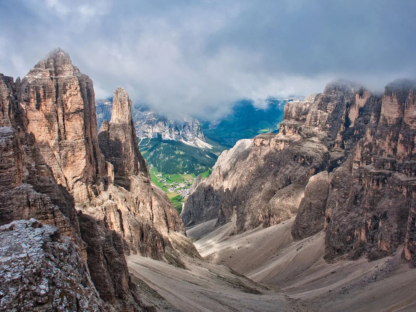
- Puez-Odle plateau: A UNESCO-listed karst tableland of pale dolomite pinnacles and pavements, crossed early in the trek. The Odle (Geisler) and Puez skyline is one of the route’s defining Dolomite landscapes.
- Sella massif and Rifugio Pisciadu: The route enters the fortress-like Sella group via cabled rock. Rifugio Pisciadu sits above a small alpine lake below steep limestone walls.
- Marmolada and Lago di Fedaia: Alta Via 2 passes beneath Marmolada, the 3,343 m highest peak in the Dolomites, near the turquoise Fedaia reservoir.
- Passo delle Farangole: At 2,932 m, this is the route’s highest point. The crossing involves steep, exposed terrain with steel cables and a ladder in the Pale di San Martino.
- Pale di San Martino and Altopiano delle Pale: Around Rifugio Rosetta, the route crosses a stark high plateau of bare dolomite, one of the most distinctive landscapes on the trek.
- Vette Feltrine / Alpi Feltrine: The final ranges lie within Dolomiti Bellunesi National Park and feel quieter and wilder, with alpine flora and the descent towards Rifugio Dal Piaz above Feltre.
Challenges to expect
Alta Via 2 is an expert alpine route, not just a long walk. Expect rocky paths, scree, exposed ledges and aided sections on several stages; stage 8 around Passo delle Farangole is the most technical. A via-ferrata kit and helmet are recommended. Snow can linger on north-facing passes into early summer, huts must be booked ahead, and the only ATM on the route is at Passo San Pellegrino.
HikeList Score
Alta Via 2 scored 79/100 on HikeList's trail-quality metrics.
See score breakdownHide breakdown
- Ideal length 89
- Balanced challenge 44
- Scenery & wildness 85
- Varied terrain 83
- Accommodation 75
- Food & support 88
- Path quality 98
- Season flexibility 76
Computed from length, challenge, scenery & wildness, terrain variety, accommodation, food & support, path quality and season flexibility.
 Italy
ItalyShow more data Show less
- Mountainous
- Alpine
- Rocky
- Rocky
- Scree
- Dirt
- Huts
- Hotels
- Campsites
- Pet Friendly
- Restrooms
- Water Sources
- Campsites
- Shelters
Photos from hikers
Taken on the trail by people who've reviewed Alta Via 2.
Begin in the historic town of Brixen (Bressanone) with a steady ascent through forested slopes and pastures. The trail gradually climbs above the valley and provides panoramic views as you approach the Plose area. Your day ends at Rifugio Plose, perched with wide open views of the Dolomite peaks beyond.
Traverse high ridges from the Plose area to enter the Puez-Odle Nature Park. The trail weaves through alpine meadows and across rocky outcrops, offering constant views of the jagged Odle group. Overnight at Rifugio Genova, strategically located in a scenic col.
A scenic trek across the wild heart of the Puez-Odle Nature Park, passing through grassy valleys and beneath vertical cliffs. This section features gentle ascents and descents before reaching Rifugio Puez, nestled in a dramatic upland basin.
Descend from the remote heights of Rifugio Puez towards Passo Gardena, a well-known Dolomite pass. The route showcases sweeping vistas of dramatic limestone formations, lush meadows, and descends into the Gardena valley.
The trail traverses the imposing Sella massif, testing your stamina across rocky trails and high-altitude paths. You’ll pass through mountain passes with jaw-dropping views and end the day at the busy mountain hub of Passo Pordoi.
Head south from Passo Pordoi, skirting the edges of the Marmolada group. Enjoy striking glacier views as you pass through rocky corridors and alpine pastures before descending to Rifugio Contrin, set in a peaceful valley.
An undulating day through lush meadows and forest sections, crossing the San Nicolò valley. The route ascends towards Passo San Pellegrino, a historic and scenic mountain pass with accommodation options.
Journey deeper into the Pale di San Martino group, traversing rugged landscapes and crossing rocky passes. Today’s route is challenging and remote, culminating at Rifugio Mulaz beneath towering Dolomite cliffs.
Continue through the wild core of the Pale di San Martino. Expect technical traverses and high-altitude trails with stunning panoramas. The day ends at Rifugio Rosetta, a well-known hut with sweeping alpine views.
Navigate through rocky plateaus and rugged passes within the Pale di San Martino. Sections include exposed ridges and steep descents as you make your way toward Rifugio Pradidali in a dramatic cirque.
Trek through remote valleys and under imposing peaks as you leave the high Dolomites. Today involves considerable elevation change, ending at Passo Cereda, where facilities and transportation links are available.
Head into quieter, wilder territory as you enter the Vette Feltrine. The terrain here is less trodden, with rolling ridges and solitude. Overnight is typically spent at the basic but atmospheric Bivacco Feltre Bodo shelter.
The final stage descends along forested ridges and panoramic slopes towards Croce d’Aune, the southern terminus of the Alta Via 2. Celebrate the completion of an epic traverse as you end in this tranquil mountain village.
Reviews
How would you rate Alta Via 2?
Tap a star to start your review — you could be the first.