Tour of Matterhorn
How would you rate Tour of Matterhorn?
Tap a star to share your experience and help other hikers.
Tour of Matterhorn: Expert Alpine Circuit Around the Cervin
HikeList Score
Tour of Matterhorn scored 82/100 on HikeList's trail-quality metrics.
See score breakdownHide breakdown
- Ideal length 94
- Balanced challenge 44
- Scenery & wildness 85
- Varied terrain 89
- Accommodation 83
- Food & support 94
- Path quality 98
- Season flexibility 63
Computed from length, challenge, scenery & wildness, terrain variety, accommodation, food & support, path quality and season flexibility.
The Tour of Matterhorn, also known as the Tour du Cervin, is a 150 km high-alpine loop around the Matterhorn on the Swiss-Italian border. Usually walked in 9-11 days, it suits experienced mountain hikers comfortable with long days, exposed passes, scree, snow and glacier travel. This is one of the more serious Swiss high-alpine hikes: Col Collon and the Theodul Glacier require crampons, an ice axe and ideally a certified mountain guide.
Route Overview
Most hikers start and finish in Zermatt, the car-free resort below the Matterhorn, though the official Zermatt Tourism staging starts at Randa and ends in Zermatt; Arolla is another possible start. The loop can be walked clockwise or anticlockwise and links the Mattertal, Turtmanntal, Val d'Anniviers, Val d'Herens, Valpelline and Aosta Valley. Key places include Gruben, Zinal, Lac de Moiry, Les Haudieres, Arolla, Prarayer, Lago di Place Moulin and Breuil-Cervinia. The return to Zermatt crosses the Theodulpass and Theodul Glacier via Trockener Steg, where optional cable cars may shorten the descent. For comparison, see the Alpine Pass Route, Bernina Trek and Diavolezza Glacier Trail.
Matterhorn History and Alpine Context
The Matterhorn, or Monte Cervino, was first summited on 14 July 1865 by a party led by Edward Whymper. Four of the seven climbers died on the descent when a rope broke, making the ascent one of mountaineering’s most famous tragedies. The valleys around the peak were long-established trade and herding routes between Valais and the Italian Aosta Valley, while Zermatt developed from a farming village into a centre of Alpine mountaineering.
Notable highlights
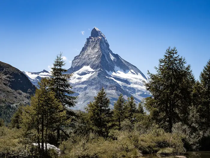
- Matterhorn (Monte Cervino, 4,478 m): The pyramid-shaped peak is the focus of the whole circuit, seen from different Swiss and Italian angles as the route moves through Valais and the Aosta Valley.
- Theodulpass (3,301 m): The highest point of the tour and a historic trans-alpine crossing between Switzerland and Italy. The descent involves the Theodul Glacier, so glacier kit and settled conditions matter.
- Col Collon: A glaciated pass reached via the Haut Glacier d’Arolla, taking walkers from Switzerland into Italy. Crampons and ideally a guide are recommended here.
- Zinal and the Val d’Anniviers: A key Valais stage village in a valley ringed by 4,000 m peaks including the Weisshorn and Dent Blanche.
- Europaweg / Europahütte: A high balcony section above the Mattertal, used on some variants, with long suspension bridges and sustained mountain terrain.
- Breuil-Cervinia: The Italian resort below the Matterhorn’s south face, marking the Aosta Valley section before the climb back towards the Theodulpass.
Challenges to expect
Expect an expert-level route: around 10,353 m of ascent, repeated high passes, rocky paths, scree, snow and ice. The Augstbordpass, Meidpass, Col de Sorebois, Col de Torrent, Col Collon, Col de Valcournera and Theodulpass all demand mountain fitness and sound judgement. Glacier crossings need equipment and experience. Book huts, guesthouses and hotels ahead, and avoid unstable weather on the high-pass days.
HikeList Score
Tour of Matterhorn scored 82/100 on HikeList's trail-quality metrics.
See score breakdownHide breakdown
- Ideal length 94
- Balanced challenge 44
- Scenery & wildness 85
- Varied terrain 89
- Accommodation 83
- Food & support 94
- Path quality 98
- Season flexibility 63
Computed from length, challenge, scenery & wildness, terrain variety, accommodation, food & support, path quality and season flexibility.
Show more data Show less
- Mountainous
- Alpine
- Glacial
- Rocky
- Scree
- Snow
- Ice
- Huts
- Hotels
- Guesthouses
- No Dogs Allowed
- Restrooms
- Potable Water Sources
- Established Campsites
- Shelters
- Public Transport Access Points
Download Our Full Guide to Tour of Matterhorn FREE!
Get our comprehensive guide to this hike for free. Save it for later reading or print out at home.
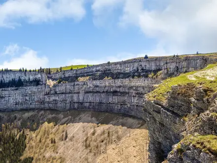
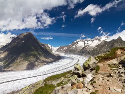
Photos from hikers
Taken on the trail by people who've reviewed Tour of Matterhorn.
Tour of Matterhorn: The Complete Guide
 i
Image by wirestock
i
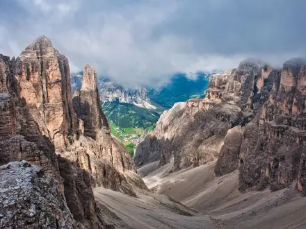
Image by wirestock The Tour of the Matterhorn (Tour du Cervin) is a serious high-alpine circuit around one of the Alps’ defining peaks, crossing between Valais in Switzerland and the Aosta Valley in Italy. It links hut nights, remote valleys and big passes from Randa and Zermatt through Gruben, Zinal, Arolla, Prarayer and Breuil-Cervinia.
This is not a gentle village-to-village walk with occasional mountain views. The route climbs repeatedly towards 3,000 m and higher, with scree, moraine, exposed ground, snowfields and two glaciated crossings shaping the character of the trek.
The reward is a constantly changing view of the Matterhorn — Monte Cervino in Italian, Mont Cervin in French — from its Swiss and Italian sides. The high point comes at the Theodulpass (Theodul Pass / Passo del Teodulo), around 3,301 m, before the final return towards Zermatt.
Most walkers need 9–11 days for the roughly 150 km circuit, allowing sensible margins for weather, hut logistics and the long Zinal to Arolla section. The best window is usually mid-July to mid-September, when the high passes are clearest and staffed huts are operating.
This route suits experienced mountain hikers with strong fitness, sure-footedness and either glacier-travel competence or a certified guide for Col Collon and the Theodul Glacier. Crampons and an ice axe are part of the planning, not optional extras to think about at the last minute.
This guide covers stages, timing, accommodation, food, transport, terrain and the common mistakes that make the Tour of the Matterhorn harder than it needs to be.
Stage-by-Stage Guide
Stage 1: Randa to Topalihütte (Topali Hut) — approx. 11 km
The tour starts with a serious mountain day straight out of the Mattertal. From Randa (1,439 m), the route leaves the valley floor and climbs towards the Topalihütte, so the first stage is more about ascent and acclimatisation than distance.
Expect steep alpine paths, rocky ground and sections where snow can linger early in the season. This is not a gentle warm-up: start with the same mountain kit and judgement needed for the rest of the circuit.
The main landmark is Randa itself, on the Matterhorn Gotthard Bahn below Zermatt. As height is gained, views open back over the Mattertal and towards the high Pennine Alps.
Food and water should be organised before leaving Randa. The Topalihütte is a staffed mountain hut in the summer season and is normally used on half-board, but hut opening dates and meal arrangements must be checked and booked ahead.
Randa has rail access on the Visp–Zermatt line, making it one of the easiest points on the circuit to reach or leave. There is no practical public-transport escape once committed to the climb to the hut.
Navigation is usually straightforward in clear weather if following the official route, but cloud, snow patches and poor visibility can make high hut approaches much more serious. Carry a proper map, offline route data and enough time margin to arrive before evening.
Stage 2: Topalihütte to Jungu — approx. 12 km
This stage continues through high Swiss-side mountain terrain before dropping towards Jungu. It is a shorter official stage by distance, but the terrain remains demanding and exposed to weather.
Underfoot conditions are likely to include rocky mountain path, scree and uneven traversing ground. Early-season snow can change both the difficulty and the line of the path, particularly on shaded or higher sections.
The stage keeps the route on the Mattertal side of the tour before the crossing towards the Turtmanntal on the following day. Views are back across the Valais peaks and along the valleys leading towards Zermatt and Randa.
There are no reliable mid-stage service points to plan around. Carry lunch, snacks and enough water from the hut; natural water should be treated where used, and availability varies with season and conditions.
Jungu is the official stage end, but accommodation and any local transport connections should be checked before travelling. Do not assume the same level of services as in larger resort villages such as Zermatt, Zinal or Arolla.
Navigation matters on this stage because it links remote high ground rather than simply following a valley. Bad weather can make it difficult to judge side paths or maintain the official line, so this is a day for conservative timing.
Stage 3: Jungu to Gruben — approx. 16 km
This is one of the key Valais pass stages, taking the route from the Mattertal side towards the Turtmanntal. The principal crossing is the Augstbordpass, at around 2,894 m.
The day involves a sustained climb to high, open terrain followed by a descent into Gruben. Expect rocky path, scree, possible snow patches and a more remote feel than the village-to-village distance might suggest.
The Augstbordpass is the main landmark and the first of the tour’s chain of major Swiss passes. In good weather it gives broad views across the Pennine 4,000 m peaks and back towards the Matterhorn region.
Food should be carried from Jungu, as the pass crossing should be treated as self-sufficient. Water availability between settlements should not be relied on without current local advice; start with enough for the climb and descent.
Gruben is a village stop in the Turtmanntal, with guesthouse or hotel accommodation typically used by trekkers. Book ahead, especially in the main summer trekking season.
Road access and onward transport from Gruben should be checked before travelling. It is a better escape point than a high hut, but it is not comparable with Zermatt or Breuil-Cervinia for transport flexibility.
Navigation over the Augstbordpass is serious in poor visibility. Snow can obscure markings and make the descent slower, so the pass should not be treated as a simple hill-walk col.
Stage 4: Gruben to Zinal — approx. 20 km
The route leaves the Turtmanntal and crosses into the Val d’Anniviers, finishing in Zinal. This is another full mountain stage, with the Meidpass forming the main high crossing of the day.
The terrain is typical of the Swiss side of the Tour of the Matterhorn: sustained climbing, open pass terrain, scree and a long descent into a settled valley. Weather changes quickly at altitude, and mist can make the upper ground feel much more committing.
Zinal is one of the most important stage villages on the circuit. It sits in the Val d’Anniviers, surrounded by major 4,000 m summits including the Weisshorn, Zinalrothorn, Ober Gabelhorn and Dent Blanche.
There should be no assumption of food services between Gruben and Zinal. Carry a packed lunch from the previous night’s accommodation and start with enough water for a long pass day.
Zinal has village accommodation, including guesthouses and hotels used by trekkers. It is also a logical place to reassess weather, fatigue and plans before the very long official stage to Arolla.
Public transport and road access from Zinal should be checked before travelling. As a valley village it offers more flexibility than the huts, but timetables and seasonal services matter.
Navigation is generally about staying on the correct pass line and not being drawn onto local paths in poor visibility. Snow on the Meidpass can make both ascent and descent slower and more tiring.
Stage 5: Zinal to Arolla — approx. 34 km
This is the hardest official stage on paper: around 34 km and commonly quoted as a very long day. Many hikers split it, often using the Val d’Hérens side and Les Haudères as a practical intermediate stop, rather than attempting the full distance in one push.
The stage links the Val d’Anniviers to the Val d’Hérens via high pass terrain, including the Col de Sorebois and Col de Torrent. Both sit close to 2,900 m and make the day much more demanding than a normal valley transfer.
Expect repeated ascent and descent, rocky mountain paths, open cols, possible snow patches and a long final approach towards Arolla. The length means small delays from weather, snow or navigation errors can become significant.
Zinal’s “Imperial Crown” of surrounding peaks is a major highlight at the start of the day. The route then moves into the Val d’Hérens, with Arolla acting as the final Swiss village base before the glaciated Col Collon crossing.
Carry a full day’s food unless accommodation has arranged an alternative. Water and refreshments between Zinal, any Val d’Hérens stop and Arolla should be checked locally; do not plan this stage around unverified service points.
Accommodation is available in Arolla, and Les Haudères is a sensible splitting point for many itineraries. Both should be booked ahead in peak season, particularly if weather delays are affecting other walkers on the same circuit.
Road access and public transport options in the Val d’Hérens should be checked before travelling. Splitting the stage also creates a useful safety buffer before the glacier day into Italy.
Navigation needs particular care because of the stage length and the number of route choices around the Val d’Hérens approach. Start early, carry offline mapping and avoid committing to the full Zinal–Arolla day unless fitness, weather and snow conditions are all favourable.
Stage 6: Arolla to Prarayer — approx. 17 km
This is one of the two genuinely glaciated stages of the Tour of the Matterhorn. From Arolla, the route crosses the Haut Glacier d’Arolla and climbs to Col Collon, around 3,069–3,114 m depending on the map reference, before entering Italy.
The terrain changes from high mountain path to glacier travel, moraine, snow and rocky pass ground. Crampons, ice axe and glacier-travel competence are required, and using a certified mountain guide is strongly advisable.
Col Collon is the key landmark and the border crossing between Switzerland and the Aosta Valley. The descent leads towards the Valpelline and the Prarayer area above Lago di Place Moulin.
There are no ordinary services on the glacier crossing. Carry all food and water needed for the day, and do not rely on being able to refill safely on the glacier or upper approach.
Rifugio Prarayer is the usual end point, sitting above Lago di Place Moulin in the Valpelline. This is the first Italian-side overnight of the circuit, so expect euros (EUR) rather than Swiss francs (CHF) and book the refuge well ahead.
Prarayer should be treated as a remote hut-style stop rather than a transport hub. Any road access or exit options on the Italian side should be checked before travelling.
Navigation and timing are critical. Glacier conditions, crevasses, snow cover and weather can change the seriousness of the stage, and this crossing should not be attempted without current conditions information and the right equipment.
Stage 7: Prarayer to Breuil-Cervinia — approx. 16 km
This stage moves through the Italian side of the circuit, leaving the Prarayer and Lago di Place Moulin area and heading towards Breuil-Cervinia in the Valtournenche. It is still a mountain day, but it finishes in a major resort rather than a hut.
Expect alpine paths, rocky sections and sustained height gain or loss as the route leaves the Valpelline and approaches the Matterhorn’s Italian side. Conditions remain weather-dependent, especially where old snow lingers on higher ground.
Lago di Place Moulin is the main early landmark, with Rifugio Prarayer set above the long turquoise reservoir. Breuil-Cervinia is the major highlight at the end of the stage, directly below the steep south face of the Matterhorn (Monte Cervino in Italian).
Food and water should be carried from Prarayer for the day. Breuil-Cervinia has resort services, but opening patterns can vary outside the busiest summer periods.
Accommodation in Breuil-Cervinia ranges from hotels and guesthouses to mountain-focused lodging. Prices and payments are in euros (EUR), and bookings should be made ahead during the summer hiking season.
Breuil-Cervinia has road access and bus links to Châtillon-Saint-Vincent, with onward rail on the Torino–Aosta line, as well as direct bus connections from Torino or Aosta. Current timetables should be checked before travelling.
Navigation is less isolated by the end of the day, but the approach into a developed ski-resort landscape can introduce multiple tracks and paths. Stay with the official Tour du Cervin line rather than following ski infrastructure by guesswork.
Stage 8: Breuil-Cervinia to Plateau Rosa / Testa Grigia — approx. 8 km
This is a short stage by distance but a serious high-altitude approach to the Theodulpass area. It climbs from Breuil-Cervinia towards Plateau Rosa / Testa Grigia, preparing for the return crossing into Switzerland.
The terrain is high alpine and increasingly influenced by snow, glacier and ski-area infrastructure. Do not judge the day by its 8 km distance: altitude, weather, snow conditions and route-finding can make it demanding.
The main landmarks are Breuil-Cervinia below and the Plateau Rosa / Testa Grigia glacier plateau above. The Matterhorn’s Italian face dominates the stage, giving one of the clearest south-side perspectives of the whole tour.
Carry food and water from Breuil-Cervinia unless relying on known open facilities; openings at altitude can change with lift operations and season. This should be checked before travelling.
Accommodation at or near Plateau Rosa / Testa Grigia should not be assumed without a confirmed booking. This is not a normal village stage, and the practical overnight plan must be fixed before setting out.
The Matterhorn Alpine Crossing lift links Breuil-Cervinia and Zermatt over the Theodulpass area and can be used for assistance or itinerary changes. Lift timetables, operating status and ticket arrangements should be checked before travelling.
Navigation can be confusing in poor visibility because glacier terrain, ski pistes, lift stations and snowfields can blur the walking line. This stage should be approached as a high-alpine transition, not as a resort path.
Stage 9: Plateau Rosa / Testa Grigia to Zermatt — approx. 11 km
The final stage crosses the Theodulpass (Theodul Pass / Passo del Teodulo), the tour’s high point at around 3,301 m, and descends over the Theodul Glacier towards Zermatt. It is one of the defining stages of the circuit and remains serious until the glacier terrain is safely behind.
This is the second major glacier section of the Tour of the Matterhorn. Crampons, ice axe and appropriate glacier-travel skills are required, and a certified mountain guide is strongly advisable unless the party is competent and equipped for current conditions.
The Theodulpass is a historic trans-Alpine crossing between Breuil-Cervinia and Zermatt. In clear weather the stage gives the final shift in perspective from the Italian side of the Matterhorn back to the Swiss Valais side.
Do not rely on food or water during the crossing unless specific facilities are known to be open that day. Carry enough from the overnight point, and allow for delays caused by snow, visibility or glacier conditions.
Zermatt has extensive accommodation but is expensive by Swiss standards and should be booked ahead. Switzerland uses Swiss francs (CHF), and Zermatt’s resort prices are often among the highest on the circuit.
Zermatt is car-free and reached by the Matterhorn Gotthard Bahn via Visp; Randa is one stop down the valley for walkers returning to the strict official start. The Matterhorn Alpine Crossing can also provide lift-based assistance over the Theodul area when operating.
Navigation on the Theodul Glacier must be based on current glacier conditions, not just a line on a map. Crevasses, snow bridges, whiteout and ski-area complexity all matter, and the final stage should be delayed or altered if conditions are unsuitable.
Getting to the Start
The official Tour du Cervin staging starts in Randa (1,439 m) in the Mattertal, below Zermatt. In practice, many hikers use Zermatt (1,620 m) as the pre- and post-trek base, then take the short rail hop to Randa for the first stage or adapt the itinerary to begin from Zermatt.
By train
Rail is the simplest way to reach the Swiss start. Randa and Zermatt are both on the Matterhorn Gotthard Bahn line from Visp, which is connected to the main Swiss rail network.
For the strict official start, travel by train to Randa and begin the climb towards Topalihütte from there. For a Zermatt-based start, continue one stop beyond Randa to Zermatt, then return to Randa by train when ready to begin.
Check current rail times carefully, especially if arriving late in the day or planning to start walking immediately after travel. This should be checked before travelling.
By bus
Bus is not the primary access method for the Swiss start: the normal approach is by rail via Visp on the Matterhorn Gotthard Bahn. Buses are more relevant on the Italian side of the circuit, where Breuil-Cervinia is reached by bus from Châtillon-Saint-Vincent or by direct bus from Torino/Aosta.
If starting the circuit from the Italian side instead of Randa/Zermatt, Breuil-Cervinia can be used as an alternative access point, but that changes the logistics and puts the Theodulpass section near the beginning or end of the itinerary. Current bus and lift timetables should be checked before travelling.
By car
Zermatt is car-free, so do not plan to drive directly into the resort. For most independent hikers, the cleanest solution is to arrive by train and avoid needing a vehicle during a 9–11 day circuit.
If driving to the Mattertal, long-stay parking arrangements and the onward connection to Randa or Zermatt need to be planned in advance. This should be checked before travelling, particularly in the summer trekking season when accommodation and transport around Zermatt are busy.
From the nearest airport
No single airport is essential for this route: the practical airport choice is usually whichever gives the best connection into the Swiss rail network and onward to Visp. From Visp, take the Matterhorn Gotthard Bahn to Randa or Zermatt.
Allow enough time for flight delays, rail connections and buying any last-minute food or mountain supplies before heading to the first hut. Starting the climb to Topalihütte late in the day is poor planning on this route, as the opening stage immediately commits you to steep alpine terrain.
Where to stay before starting
Randa is the most logical overnight stop if following the official itinerary exactly and wanting to start walking directly from the trailhead. It is quieter and places you at the correct start for the first stage to Topalihütte.
Zermatt is the more common practical base, with far more services and easy rail access back to Randa. It is also the natural place to finish the circuit after descending from the Theodulpass, but prices in Zermatt are high by Swiss standards and accommodation should be booked ahead.
All Swiss-side costs before the start will be in Swiss francs (CHF). If the itinerary later crosses into Italy via Col Collon and Breuil-Cervinia, carry or arrange payment in euros (EUR) for the Aosta Valley section as well.
Reviews
How would you rate Tour of Matterhorn?
Tap a star to start your review — you could be the first.