Presqu’île de Crozon Trail
How would you rate Presqu’île de Crozon Trail?
Tap a star to share your experience and help other hikers.
Presqu’île de Crozon Trail: A 3-Day GR34 Coastal Hike
HikeList Score
Presqu’île de Crozon Trail scored 86/100 on HikeList's trail-quality metrics.
See score breakdownHide breakdown
- Ideal length 70
- Balanced challenge 100
- Scenery & wildness 98
- Varied terrain 52
- Accommodation 92
- Food & support 88
- Path quality 98
- Season flexibility 89
Computed from length, challenge, scenery & wildness, terrain variety, accommodation, food & support, path quality and season flexibility.
The Presqu’île de Crozon Trail is a 60 km, 3-day, moderate coastal hike on the GR34 in western Brittany, France. This point-to-point section runs between Camaret-sur-Mer and Telgruc-sur-Mer, tracing cliffs, beaches and headlands around the Crozon peninsula in Finistère. It suits hikers who want dramatic Atlantic coastline without technical mountain terrain, but expect repeated short climbs, exposed clifftops, rocky path and limited resupply between towns.
Route Overview
This is the popular three-day highlight section of the GR34 Sentier des Douaniers, not the full Crozon peninsula loop. It can be walked in either direction between Camaret-sur-Mer and Telgruc-sur-Mer, with Morgat roughly midway and Crozon serving as the main inland transport and service hub. The route links Pointe de Pen-Hir, the Tas de Pois sea stacks, Pointe de Dinan, Cap de la Chèvre, Saint-Hernot, Plage de l’Île Vierge, Morgat, Plage de Goulien and Telgruc-sur-Mer. For other French coastal trips, compare the Bordeaux to Arcachon Trail or the D-Day Beaches Circuit; for a higher-mountain contrast, see the Cirque de Gavarnie Trails.
Customs Paths, Forts and the Coast of Brest
Crozon’s coast has long guarded the approaches to Brest, one of France’s major naval ports. Camaret-sur-Mer was fortified by Vauban in the late 1600s, and the headlands still carry traces of gun batteries, towers and wartime defences. The walking route follows the Sentier des Douaniers, the old customs officers’ path created so officials could patrol the coast against smugglers. These paths were later revived for walkers and became part of the GR34 around Brittany.
Notable highlights
- Pointe de Pen-Hir: Crozon’s best-known headland, with sheer cliffs and the Tas de Pois line of offshore sea stacks. On clear days, views can reach towards Ouessant and the Pointe du Raz.
- Cap de la Chèvre: The wild southern tip of the peninsula, with heath, an old semaphore station and wide views across the Baie de Douarnenez. The clifftop walking here is exposed and memorable.
- Morgat: A sheltered seaside resort with a long sandy beach, marina and sea caves reached by boat. It is also the main midway resupply stop on this section.
- Pointe de Dinan: A jagged headland above the Anse de Dinan. Its detached rock formation, the Château de Dinan, resembles a ruined castle linked to the cliff by a natural arch.
- Sentier des Douaniers (GR34): The historic customs officers’ path that now forms Brittany’s long-distance coastal GR34. On Crozon it gives continuous cliff, beach and headland walking.
Challenges to expect
The trail is waymarked and non-technical, but it is not flat. Expect repeated short, steep climbs and descents on narrow dirt and rocky cliff-path, with roots, sand, sunken lanes and slippery sections after rain. Atlantic wind and wet weather are possible year-round. Resupply is limited, especially between Camaret-sur-Mer and Morgat, and accommodation should be booked ahead in season.
HikeList Score
Presqu’île de Crozon Trail scored 86/100 on HikeList's trail-quality metrics.
See score breakdownHide breakdown
- Ideal length 70
- Balanced challenge 100
- Scenery & wildness 98
- Varied terrain 52
- Accommodation 92
- Food & support 88
- Path quality 98
- Season flexibility 89
Computed from length, challenge, scenery & wildness, terrain variety, accommodation, food & support, path quality and season flexibility.
 France
Show more data Show less
- Coastal
- Dirt
- Rocky
- Hotels
- Campsites
- Hostels
- Wild Camping Spots
- Family Friendly
- Pet Friendly
- Restrooms
- Water Sources
- Campsites
- Picnic Areas
Download Our Full Guide to Presqu’île de Crozon Trail FREE!
Get our comprehensive guide to this hike for free. Save it for later reading or print out at home.

In these collections
Photos from hikers
Taken on the trail by people who've reviewed Presqu’île de Crozon Trail.
Presqu’île de Crozon Trail: The Complete Guide
 i
Image by phildu56
i
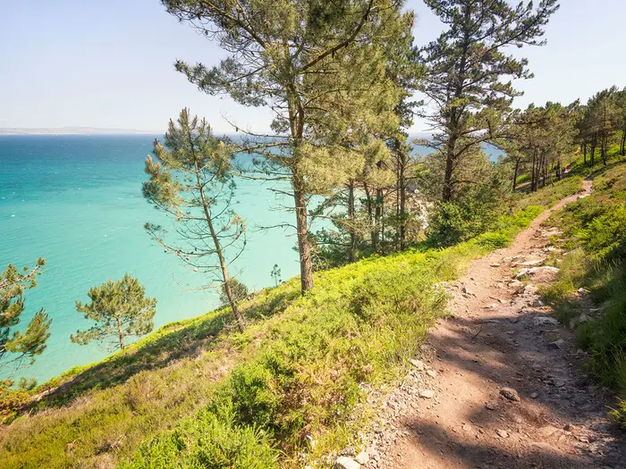
Image by phildu56 The Presqu’île de Crozon Trail is a compact, three-day hit of Brittany coast walking on the GR34 Sentier des Douaniers. It links Camaret-sur-Mer with Telgruc-sur-Mer by a waymarked clifftop line of headlands, beaches, heath and small seaside settlements.
This is the Crozon peninsula at its most Atlantic: Pointe de Pen-Hir and the Tas de Pois, Pointe de Dinan, Cap de la Chèvre, Morgat and the open sweep of the Baie de Douarnenez. The route is low in altitude, but rarely flat, with the path repeatedly dropping to sand and climbing back to exposed cliff.
It suits reasonably fit walkers who want a first multi-day coastal GR with strong scenery and straightforward navigation. The red-and-white waymarks are a major advantage, but accommodation and food stops still need planning, especially outside the main hubs of Camaret-sur-Mer, Morgat, Crozon and Telgruc-sur-Mer.
What the walk asks for is not mountaineering skill, but steady legs, sure feet and proper Atlantic-weather kit. Expect narrow rocky path, muddy or slippery ground after rain, wind, drizzle and limited resupply between towns.
This guide covers stages, daily planning, accommodation, food, transport, terrain and the common mistakes to avoid.
Stage-by-Stage Guide
Distances on this coast vary slightly with exact accommodation, beach access and any temporary clifftop diversions. The GR34 is well waymarked with red-and-white GR blazes, but this is not a promenade: the days are shaped by repeated short climbs, narrow rocky path, exposed cliff edges and limited resupply away from the main settlements.
Stage 1: Camaret-sur-Mer to Plage de Goulien — approx. 17 km
The first stage leaves Camaret-sur-Mer from the harbour, with the Tour Vauban and the ruined Chapelle Notre-Dame-de-Rocamadour close to the start. The GR34 then works out towards the north-western headlands of the peninsula, quickly becoming a coastal path rather than a town walk.
Expect narrow dirt and rocky single-track, heathland, short steep rises and descents, and sections exposed to Atlantic wind. The route is low in altitude, but the effort comes from the constant undulation and the need to watch footing on rock, sand and muddy ground after rain.
The main headland landmarks are Pointe du Toulinguet and Pointe de Pen-Hir. Pointe de Pen-Hir is one of the key viewpoints of the whole route, looking out over the Tas de Pois sea stacks; on clear days views can extend far along the Iroise coast.
After the headlands, the GR continues southwards above the west-facing beaches, passing towards Plage de Kersiguénou and Plage de Goulien. These beaches are dramatic walking landmarks rather than reliable swimming stops: the Atlantic-facing sands on this side of Crozon are known for strong currents, and bathing may be dangerous or unsupervised.
Food and water should be sorted in Camaret-sur-Mer before setting off. Once beyond the town, services are limited and should not be assumed at the beaches or headlands. Carry enough water for the full stage, especially in warm weather or if staying away from a main village.
Accommodation at or near Plage de Goulien is thinner than in Camaret-sur-Mer, Morgat or Telgruc-sur-Mer. Book well ahead in summer and check exactly how far the bed is from the GR34; some walkers may need a short transfer or a pre-arranged pick-up from accommodation.
Camaret-sur-Mer is the straightforward public-transport access point for this stage, reached by BreizhGo coach services from Brest or Quimper via the peninsula. For a finish around Goulien, public transport is less straightforward than at the main towns; smaller-place transport may require on-demand services. This should be checked before travelling.
Navigation is generally simple if the red-and-white GR waymarks are followed, but pay attention where the path drops towards beaches or meets minor tracks. Avoid informal cliff-edge trods, especially in wind or poor visibility, and obey any local diversion signs where erosion or instability affects the coast path.
Stage 2: Plage de Goulien to Saint-Hernot / Morgat — approx. 22 km
This is the wildest and most sustained stage of the three-day itinerary. It links the Atlantic beaches with the great southern headlands of the Presqu’île de Crozon, with long stretches where the walking feels remote despite the modest altitude.
From the Goulien area, the GR34 continues over coastal heath and cliff path towards Pointe de Dinan. The headland is known for the Château de Dinan rock formation, where a detached mass linked by a natural arch gives the appearance of a ruined castle above the Anse de Dinan.
The route then passes the Plage de la Palue area before continuing towards Pointe de Rostudel and Cap de la Chèvre. Plage de la Palue is another exposed Atlantic beach associated with strong currents; treat it as a scenic waypoint, not a guaranteed safe swimming stop.
Cap de la Chèvre is the major highlight of the day. The path rounds the southern tip of the peninsula through open heath, with the French Navy semaphore station on the headland and wide views across the Baie de Douarnenez and the Iroise Sea.
The walking remains non-technical, but this stage can feel harder than the numbers suggest. Repeated short climbs, rocky steps, wind exposure and wet ground after rain make steady pacing important, particularly if continuing all the way into Morgat rather than stopping around Saint-Hernot.
Food and water are limited between the stage ends. Start with a full day’s supply from accommodation or from the previous day’s arrangements; Morgat is the main midway resupply stop on the whole route, but it comes at the end of this stage if walking north-to-south.
Saint-Hernot gives access to the Plage de l’Île Vierge area and the Maison des Minéraux, while Morgat offers the strongest range of practical services for walkers. Most hikers will find Morgat the easier overnight base, with hotels, guesthouses, gîtes/hostels and campsites concentrated around the resort and nearby Crozon hub.
Morgat and Crozon are useful transport points, with BreizhGo services linking the main peninsula settlements. If ending at Saint-Hernot rather than Morgat, check the exact access to accommodation and any on-demand transport before committing to the itinerary.
Navigation around Cap de la Chèvre and the approach to Saint-Hernot is mainly a matter of staying with the GR34 and resisting shortcuts close to the cliff edge. In poor weather, the open heathland headlands can feel exposed, and the waymarks become especially important where minor paths branch towards viewpoints, coves or car parks.
Access to Plage de l’Île Vierge and nearby coves can be affected by tide and local restrictions. Optional descents should be treated separately from the main walking plan and checked before travelling.
Stage 3: Saint-Hernot / Morgat to Telgruc-sur-Mer — approx. 24 km
The final stage turns the route towards the more sheltered Baie de Douarnenez side, but it is still a proper coastal GR day rather than an easy beach walk. At around 24 km, it is the longest of the three listed stages and deserves an early start if relying on onward transport or a fixed booking in Telgruc-sur-Mer.
If starting from Morgat, the day begins with the practical advantage of shops and services in the resort area. Morgat is also known for its sea caves, reached by boat rather than as part of the walking route, and its long sandy beach makes it a useful place to organise food before leaving the main settlement.
Crozon is the inland hub for the peninsula and can be useful for services and transport planning, even though the appeal of this stage remains the coast. Beyond the Morgat/Crozon area, do not assume regular resupply until Telgruc-sur-Mer.
The GR34 continues towards the Île de l’Aber area, then onwards by Pointe du Bellec and Plage de Trez-Bellec. The views open south across the Baie de Douarnenez, with a different character from the wilder Atlantic headlands of the previous two days.
Terrain remains mixed: coastal path, sandy stretches, sunken lanes, scrub and cliff sections, with short climbs and descents continuing all the way through the day. After rain, shaded or compacted sections can be slippery, and sandy approaches to beaches can be slower than expected.
Carry lunch and enough water from Morgat or the overnight base. Telgruc-sur-Mer is the end-of-route service point, but the ground between the main settlements is not a place to rely on spontaneous cafés, shops or water points.
Accommodation in Telgruc-sur-Mer includes the kind of small-resort options typical of the peninsula, but summer beds should be booked in advance. Wild camping is restricted on the route, so the final night should be planned rather than left to chance.
For public transport, Telgruc-sur-Mer is one of the key bus-linked settlements on the peninsula, with BreizhGo services connecting towards Crozon, Camaret-sur-Mer, Brest and Quimper depending on line and timetable. Current BreizhGo times should be checked before travelling, particularly for weekends, holidays and end-of-day departures.
The Île de l’Aber area is a place to be tide-aware if planning any optional access beyond the main path. The GR34 itself should be followed by its red-and-white blazes, and any beach or islet detour should only be taken when conditions and access are clear.
The main warnings on this final day are distance, slippery ground after rain, exposed unfenced clifftop sections and the temptation to underestimate the remaining climbs. Keep enough time in hand for the approach to Telgruc-sur-Mer, especially if using a bus connection at the finish.
Recommended Itinerary
Standard 3-day itinerary
This is the classic way to walk the southern-coast highlight section between Camaret-sur-Mer and Telgruc-sur-Mer. It keeps the route to three substantial coastal days, but the stage ends need planning carefully because accommodation and resupply are not evenly spaced.
| Day | From | To | Approx. distance | Why this stage makes sense | Services/accommodation notes |
|---|---|---|---|---|---|
| 1 | Camaret-sur-Mer | Plage de Goulien | 17 km | A manageable first day out of Camaret-sur-Mer, following the GR34 past the north-western headlands, including Pointe du Toulinguet and Pointe de Pen-Hir. It gives enough time for the rocky, exposed clifftop sections without making the first day too long. | Camaret-sur-Mer has the strongest start-of-route services. Around Plage de Goulien, accommodation and food options are limited compared with the towns, so the overnight stop must be arranged in advance. If no suitable bed is available, adjust the stage or organise a pre-booked transfer. |
| 2 | Plage de Goulien | Saint-Hernot / Morgat | 22 km | This is the main wild-headland day, taking in Pointe de Dinan, Plage de la Palue, Pointe de Rostudel and Cap de la Chèvre before turning towards Saint-Hernot and Morgat. It is not technically difficult, but the repeated short climbs and descents make it feel more demanding than the low altitude suggests. | Saint-Hernot is useful for the Plage de l’Île Vierge area, but Morgat is the better overnight base for most walkers, with the main midway resupply on this section. Crozon, inland from Morgat, is the wider local hub. Book ahead in summer. |
| 3 | Saint-Hernot / Morgat | Telgruc-sur-Mer | 24 km | A longer final day, leaving the Morgat side and continuing towards Île de l’Aber, Pointe du Bellec, Plage de Trez-Bellec and Telgruc-sur-Mer. It works well because Telgruc-sur-Mer is a practical finish point with onward bus connections. | Stock up before leaving Morgat if starting there, as services are thinner once back on the coast. Telgruc-sur-Mer has accommodation and bus access, but onward BreizhGo times should be checked before travelling. Check tide times if planning to visit Île de l’Aber or Plage de l’Île Vierge rather than simply following the clifftop GR. |
Slower variant
A slower version suits walkers who want shorter days, more time on the headlands, or a safer margin for Atlantic wind, drizzle and slippery ground. The most practical approach is to add an extra night around Morgat/Crozon or to use accommodation/transport to avoid forcing a long day where beds are thin.
Do not assume every beach or headland has nearby lodging. Exact stage splits depend on where accommodation is available, and this should be checked before travelling. BreizhGo buses link the main peninsula settlements, with on-demand transport for smaller villages, but current timetables must be checked before relying on them.
Faster variant
The 3-day schedule is already a compact itinerary for a 60 km coastal route with around 1,040 m of cumulative ascent. Compressing it further is only sensible for very fit walkers carrying light packs and comfortable with long days on rough, exposed clifftop path.
A faster plan should be built from current mapping and confirmed accommodation rather than assumed from the headline distance. There are limited resupply points between the main towns, and missing a booked bed or bus on the peninsula can be awkward.
Planning the Route
How many days to allow
Most walkers should plan this as a 3-day walk between Camaret-sur-Mer and Telgruc-sur-Mer. That gives enough time for the repeated short climbs and descents, headland detours, weather delays and the practical reality that services are concentrated in a few settlements rather than evenly spaced along the coast.
The route can be walked quickly by strong hikers, but it is not a trail that rewards rushing. The terrain is low in altitude, yet the clifftop path is rarely flat for long, and wet rock, mud, sand and Atlantic wind can slow progress significantly.
A 4th day is sometimes added by extending around the Rade de Brest side via Roscanvel and Le Fret, but that changes the character of the itinerary from the southern-coast highlight section into a longer peninsula walk. If adding this, check accommodation and transport carefully before committing.
Natural stage planning
Daily stages are mainly dictated by where beds, food and bus access exist. Camaret-sur-Mer, Morgat, Crozon and Telgruc-sur-Mer are the key planning points; between them, options are thinner and should not be assumed available without booking.
A practical 3-day split is:
| Day | Stage | Planning notes |
|---|---|---|
| 1 | Camaret-sur-Mer to Plage de Goulien | A headland-heavy first day via Pointe du Toulinguet and Pointe de Pen-Hir. Check accommodation or pickup arrangements around the Goulien area before relying on this stop. |
| 2 | Plage de Goulien to Saint-Hernot / Morgat | The wildest-feeling section, passing Pointe de Dinan, Plage de la Palue, Pointe de Rostudel and Cap de la Chèvre before turning towards Saint-Hernot and Morgat. Morgat is the main midway resupply point. |
| 3 | Saint-Hernot / Morgat to Telgruc-sur-Mer | A longer final stage through the eastern side of the route, with Crozon as the inland hub and the coast continuing towards Île de l’Aber, Pointe du Bellec, Plage de Trez-Bellec and Telgruc-sur-Mer. |
Some walkers will prefer to sleep in Morgat rather than Saint-Hernot, as Morgat has more services and is a more obvious resupply stop. The exact daily distances can shift depending on where accommodation is available, whether beach approaches are included, and how transport is used at the start or end of a day.
Direction of travel
The route works in either direction. Camaret-sur-Mer to Telgruc-sur-Mer is a natural west-to-east progression from the Vauban harbour and major Atlantic headlands towards the Baie de Douarnenez side, but Telgruc-sur-Mer to Camaret-sur-Mer is equally valid.
Choose direction mainly around accommodation availability, BreizhGo bus times and onward travel from Brest or Quimper. There is no railway on the peninsula, so the bus plan matters more than the direction itself.
Shortening, extending and section hiking
Shortening the walk is practical because the peninsula is served by BreizhGo buses linking Camaret-sur-Mer, Crozon, Morgat and Telgruc-sur-Mer, with on-demand transport for smaller villages. Current timetables and TAD arrangements should be checked before travelling, especially outside the main season.
Section hiking is also realistic if based in one of the larger settlements and using buses or pre-arranged transfers. Morgat and Crozon are the most useful mid-route bases because they sit near the centre of the itinerary and have better access to food and services than the smaller coastal points.
Extending the walk is possible by continuing onto the longer Tour de la presqu’île de Crozon, including the Rade de Brest side via Roscanvel, Pointe des Espagnols, Le Fret and Landévennec. Do not assume the logistics are the same as the 3-day southern-coast section; accommodation spacing, bus connections and daily distances need a separate plan.
What to book first
Accommodation should be the first fixed item. Beds are concentrated in Camaret-sur-Mer, Crozon, Morgat and Telgruc-sur-Mer, with fewer options between towns, and summer availability can be tight.
Wild camping is restricted, and bivouac is only tolerated in places, so it should not be treated as the default backup plan. If camping, use official campsites or check local rules before setting out.
Transport should be planned at the same time as accommodation. BreizhGo line 34/934 links Brest with Crozon, Telgruc and Camaret, and line 37/937 links Quimper with Camaret; current timetables should be checked before travelling.
Food and water planning
Carry enough food and water for long gaps between services. Morgat is the main midway resupply stop, while Camaret-sur-Mer, Crozon and Telgruc-sur-Mer are the other key places for supplies.
Do not rely on beach cafés, small seasonal outlets or isolated villages being open at the exact time needed. In spring and autumn especially, opening hours can be limited, and in summer popular places may still be busy or fully booked.
Navigation and route-finding
The walk follows the GR34, marked with the standard red-and-white GR blazes. The waymarking is a major advantage, but the path is still a real coastal trail with narrow clifftop sections, rocky drops, sandy beach exits and occasional inland links.
Carry an offline map or GPS track as well as the waymarks. The recommended paper map for detailed planning is IGN TOP 25 0417ET, Presqu’île de Crozon.
Clifftop paths can be diverted after erosion, storm damage or local access work. Any current diversions should be checked before travelling, and on the trail, follow official signs rather than trying to force the old line.
Weather, tides and safety planning
Weather planning matters more here than altitude planning. The route’s high points are only the coastal headlands, but exposure to Atlantic wind, drizzle and slippery ground can make a moderate day feel much harder.
Pack waterproofs, a warm layer and footwear with reliable grip even in summer. The path can be narrow, rocky and unfenced, so strong wind and wet rock deserve caution rather than speed.
Swimming should not be treated as a guaranteed safe option on the wild west-facing beaches such as Plage de la Palue and Plage de Goulien, where strong currents can be dangerous and beaches may be unsupervised.
Tide times are worth checking for visits around Île de l’Aber and Plage de l’Île Vierge. The main GR34 route can be planned without making tidal crossings, but beach access, side visits and low-level coastal approaches can be affected.
Towns, Villages and Overnight Stops
Accommodation and resupply are concentrated in the named settlements, not on the headlands. For the classic 3-day Camaret-sur-Mer to Telgruc-sur-Mer itinerary, the practical overnight bases are Camaret-sur-Mer, the Plage de Goulien area, Saint-Hernot / Morgat, and Telgruc-sur-Mer, with Crozon as the inland service hub.
Book accommodation well ahead in summer. Beds are thin between towns, wild camping is restricted, and bivouac is only tolerated in places, so do not assume it is possible to improvise a legal overnight stop on the coast.
Camaret-sur-Mer
Camaret-sur-Mer is the usual western start point, with the GR34 red-and-white waymarks leading out from the harbour. It is a practical place to arrive the day before walking, especially if travelling by bus from Brest or Quimper.
Accommodation is one of the better-supported options on this section, with hotels, guesthouses, gîtes/hostels and campsites concentrated in Camaret-sur-Mer and the other main settlements on the peninsula. Food shopping and evening meals should be sorted here before starting, as the first day quickly becomes a coastal headland walk with limited resupply.
Transport is bus-based: the peninsula has no railway. BreizhGo line 34/934 links Brest with Crozon, Telgruc-sur-Mer and Camaret-sur-Mer, while line 37/937 links Quimper with Camaret-sur-Mer. Check current BreizhGo timetables before travelling, particularly for weekend, holiday and out-of-season services.
Camaret is also worth allowing time for because the route starts beside one of the peninsula’s key landmarks: the Tour Vauban and the ruined Chapelle Notre-Dame-de-Rocamadour by the harbour. Once the path leaves town towards Pointe du Toulinguet and Pointe de Pen-Hir, services become sparse.
Plage de Kersiguénou and Plage de Goulien
These west-facing beaches sit on the first day’s coastal section after Pointe de Pen-Hir and before Pointe de Dinan. Plage de Goulien is used as the first overnight area in the 3-day split, but it should be treated as a planned stop rather than a town with reliable turn-up-and-find services.
Accommodation and food options in this part of the route are limited compared with Camaret-sur-Mer, Morgat, Crozon and Telgruc-sur-Mer. Any bed, campsite place, evening meal or breakfast arrangement should be booked and checked before relying on it.
This is not a good place to arrive without a confirmed plan, especially in summer. Carry enough food and water from Camaret-sur-Mer to cover the day and any gap before the next confirmed service.
The beaches are popular with surfers and are known for strong currents. Swimming can be dangerous or unsupervised, so they should be treated as wild Atlantic beaches rather than easy bathing stops.
Saint-Hernot
Saint-Hernot sits inland from the coast near Plage de l’Île Vierge and the Maison des Minéraux, on the approach to Morgat. It is a useful stage-end option for walkers who want to break the route before dropping fully into Morgat, but it has fewer services than the resort itself.
Accommodation here should be arranged in advance. Do not rely on finding food or a bed on arrival without booking; this part of the peninsula is still between the main service centres.
Saint-Hernot is useful because it sits close to one of the most visited coves on the route, Plage de l’Île Vierge, and gives a shorter finish after the exposed Cap de la Chèvre section. Check any current access restrictions, clifftop diversions and local advice before planning a detour to the cove.
For transport, smaller villages may be served by on-demand transport rather than regular through buses. This should be checked before travelling.
Morgat
Morgat is the main midway resupply stop on the route and one of the most practical overnight bases. It sits on the sheltered eastern side of the peninsula section, after the Cap de la Chèvre and Plage de l’Île Vierge part of the walk when heading from Camaret-sur-Mer to Telgruc-sur-Mer.
Accommodation is generally more realistic here than in the smaller coastal hamlets, with the peninsula’s main mix of hotels, guesthouses, gîtes/hostels and campsites concentrated in places such as Morgat, Camaret-sur-Mer, Crozon and Telgruc-sur-Mer. Summer demand is high, so book ahead rather than treating it as a flexible fallback.
Morgat is the best place on the route to reset: buy food, eat properly, dry kit, and prepare for the final stage towards Île de l’Aber, Pointe du Bellec and Telgruc-sur-Mer. Opening hours can vary seasonally, so confirm current shop and restaurant availability before depending on a late arrival.
BreizhGo buses link the main settlements on the peninsula, including Camaret-sur-Mer, Crozon, Morgat and Telgruc-sur-Mer. Check current timetables before travelling, as they are central to joining, leaving or shortening this point-to-point walk.
Morgat is also known for its beach, marina and sea caves, but for hikers its main value is practical: it is the strongest mid-route service point.
Crozon
Crozon is the inland hub for the peninsula rather than a coastal stage point on the GR34 line described here. It is useful for transport, resupply and accommodation logistics, especially if Morgat accommodation is full or if a bus connection is needed.
The main BreizhGo services pass through or link with Crozon, including the Brest line 34/934 and the Quimper line 37/937. The same network connects the principal places along the route, with on-demand transport for smaller villages. This should be checked before travelling.
Crozon can work as an overnight alternative to Morgat, but using it may mean leaving the immediate coastal line and returning to it. Allow for that extra transfer or walking time when planning the stage; do not assume it is a seamless GR34 stop.
As the inland service centre, Crozon is a sensible place to solve practical problems: food, onward transport, and backup accommodation. It is less convenient if the priority is staying directly on the coast each night.
Île de l’Aber, Pointe du Bellec and Plage de Trez-Bellec
These places fall on the final approach to Telgruc-sur-Mer. They are scenic coastal points rather than primary overnight bases, so plan the day around reaching Telgruc-sur-Mer unless a confirmed local arrangement has been made.
Île de l’Aber is a tidal islet with old fortifications, and tide times matter for any close approach or visit. Check tide times before relying on access.
Plage de Trez-Bellec is a quiet beach on the Baie de Douarnenez side of the peninsula. As with the other non-town stops, do not assume food, water or accommodation will be available without checking in advance.
Telgruc-sur-Mer
Telgruc-sur-Mer is the usual finish for the south-coast highlight section when walking from Camaret-sur-Mer. It is a small resort and beach village above the Baie de Douarnenez, and it can equally be used as the starting point if walking the route in reverse.
Accommodation is part of the main peninsula mix, with hotels, guesthouses, gîtes/hostels and campsites concentrated in Camaret-sur-Mer, Crozon, Morgat and Telgruc-sur-Mer. Book ahead in summer, especially if finishing on a weekend or during French holiday periods.
For food and onward logistics, Telgruc-sur-Mer should be treated as the final service point of the route rather than somewhere to arrive without a plan. Confirm current opening hours and accommodation check-in arrangements before setting off from Morgat or Saint-Hernot.
BreizhGo line 34/934 links Telgruc-sur-Mer with Brest via Crozon and continues towards Camaret-sur-Mer. This makes Telgruc useful for returning to the rail network at Brest or for connecting back along the peninsula, but current bus times must be checked before travelling.
Getting to the Start
By train
The Presqu’île de Crozon has no railway, so the rail approach is to take a train to either Brest or Quimper, then continue by BreizhGo coach to Camaret-sur-Mer.
Both Brest and Quimper are TGV rail gateways for Finistère. For most walkers arriving from elsewhere in France, the simplest plan is to book rail travel to one of these cities, then match the onward coach to Camaret-sur-Mer. This should be checked before travelling.
Allow a realistic buffer between train and bus. Missing the coach connection can leave few easy alternatives, especially if starting the walk the same day or arriving outside the main daytime travel window.
By bus
BreizhGo regional coaches are the key public transport link for this route.
| Approach | Public transport link |
|---|---|
| From Brest | BreizhGo line 34/934 runs via Crozon and Telgruc-sur-Mer to Camaret-sur-Mer |
| From Quimper | BreizhGo line 37/937 runs to Camaret-sur-Mer |
| Along the route | The same network links Camaret-sur-Mer, Crozon, Morgat and Telgruc-sur-Mer, with on-demand transport for smaller villages |
Current BreizhGo timetables should be checked before travelling, especially if arriving at weekends, in the evening, or outside the main holiday season. Do not assume that a late train arrival will connect conveniently with the final coach to Camaret-sur-Mer.
The walking route starts at Camaret-sur-Mer harbour, where the GR34 red-and-white waymarks lead out from the port area. If staying elsewhere on the peninsula before the first stage, check the exact morning bus connection into Camaret-sur-Mer before booking accommodation.
By car
Camaret-sur-Mer is reachable by road and is a practical starting point if being dropped off. The complication is that this is a point-to-point walk finishing at Telgruc-sur-Mer, not a circuit, so car logistics need planning in advance.
If leaving a vehicle in Camaret-sur-Mer, check local long-stay parking rules before travelling. Do not rely on being able to leave a car for several days in a central harbour space without verifying restrictions.
A common alternative is to park near the finish at Telgruc-sur-Mer, take the BreizhGo bus back to Camaret-sur-Mer, then walk back to the car over the three days. This only works if the bus timing fits the start day. This should be checked before travelling.
Taxis may be useful for awkward links, missed buses or luggage transfers, but availability on the peninsula should not be assumed at short notice. Pre-book any essential taxi movement, particularly in summer.
From the nearest airport
For walkers flying in, the practical onward plan is still to connect through Brest or Quimper, then use the BreizhGo coach network to reach Camaret-sur-Mer. Airport-to-station transfers and onward coach times should be checked before booking flights.
Avoid flight itineraries that arrive too late to make the final onward bus to the peninsula. If the timing is tight, stay overnight in Brest or Quimper and travel to Camaret-sur-Mer the following morning.
Where to stay before starting
The most convenient pre-walk base is Camaret-sur-Mer, as the GR34 leaves directly from the harbour area. Staying there removes the risk of a morning bus delay before the first stage and gives an easier start onto the clifftop path towards Pointe du Toulinguet and Pointe de Pen-Hir.
Accommodation is concentrated in Camaret-sur-Mer, Crozon, Morgat and Telgruc-sur-Mer, with beds thinner between towns. Book well ahead in summer, especially if the first night after starting is planned around the Plage de Goulien area rather than a larger settlement.
If Camaret-sur-Mer is full, Crozon or Morgat can work as pre-walk bases, but the morning transfer to Camaret-sur-Mer must be planned around the BreizhGo timetable or a pre-booked taxi. This should be checked before travelling.
Getting Home from the Finish
By train
Telgruc-sur-Mer has no railway station. The practical railheads for leaving the Presqu’île de Crozon are the TGV stations at Brest and Quimper, reached by BreizhGo coach from the peninsula.
Allow a generous connection margin when booking onward trains. Bus times on the peninsula are timetable-dependent, and services may be limited outside peak periods, on Sundays and in the evening. This should be checked before travelling.
By bus
Public transport from the finish is bus-based. BreizhGo coaches link Telgruc-sur-Mer with the peninsula’s main hubs, including Crozon, Morgat and Camaret-sur-Mer, with onward connections towards Brest and Quimper.
The key services to check are:
| Direction | Practical use after finishing in Telgruc-sur-Mer |
|---|---|
| Brest via Crozon | Useful for TGV connections from Brest and onward travel north or west in Brittany. |
| Quimper | Useful for TGV connections from Quimper and onward travel south or east. |
| Camaret-sur-Mer / Morgat / Crozon | Useful if returning to the start, collecting a car, or staying another night on the peninsula. |
BreizhGo line numbers used for the peninsula include 34/934 and 37/937. Check the current BreizhGo timetable before committing to a same-day train, especially if finishing late in the afternoon.
For smaller villages and less frequent links, transport à la demande services may operate locally. These are not a substitute for checking the main bus timetable in advance and usually need advance arrangement.
By car/taxi
If a car has been left at Camaret-sur-Mer, plan the return from Telgruc-sur-Mer by BreizhGo bus via the peninsula’s road hubs, or arrange a taxi transfer. Taxi availability should not be assumed at the end of the walking day, particularly in summer evenings or outside the main towns.
For groups, a pre-booked taxi between Telgruc-sur-Mer and the start or accommodation elsewhere on the peninsula can be simpler than timing the walk around a bus. Confirm the pick-up point clearly, as the GR34 finish, beach area and village centre may not be the same place for every accommodation or itinerary.
From the nearest airport
Airport logistics are secondary on this route: the reliable public-transport planning points are Brest and Quimper TGV stations, connected to the peninsula by BreizhGo coach. If flying out after the walk, check current airport choices, airport transfers and bus-to-rail connections before travelling.
Do not plan a tight same-day flight after finishing in Telgruc-sur-Mer unless the final bus, onward rail link and airport transfer all line up with plenty of margin.
Where to stay at the finish
Staying overnight in Telgruc-sur-Mer is often the safest plan if the final day runs late, the weather slows progress, or onward buses do not connect neatly with trains. Accommodation on the peninsula is seasonal and can be thin in summer, so book ahead rather than relying on finding a bed after arrival.
If Telgruc-sur-Mer is full or bus times suit better, consider moving on to Crozon, Morgat or Camaret-sur-Mer for the night. These are the main accommodation and transport hubs on the route, but onward travel still depends on current BreizhGo timetables.
Which Direction Should You Walk?
There is no essential technical reason to walk this section in only one direction. The route is a point-to-point coastal GR, and it is commonly practical both ways between Camaret-sur-Mer and Telgruc-sur-Mer.
This guide uses Camaret-sur-Mer to Telgruc-sur-Mer, which gives a logical north-west to south-east traverse of the southern and western coast. The reverse direction, Telgruc-sur-Mer to Camaret-sur-Mer, is equally valid and is used by some itineraries.
Camaret-sur-Mer to Telgruc-sur-Mer
Starting in Camaret-sur-Mer gives an immediate, memorable opening: the harbour, Tour Vauban and the GR34 waymarks leading out towards the western headlands. The first part of the walk reaches the dramatic Atlantic coast around Pointe du Toulinguet, Pointe de Pen-Hir and the Tas de Pois before continuing towards Pointe de Dinan and Cap de la Chèvre.
This direction puts many of the most exposed western headlands early in the route. The final day then feels slightly more settled in character, passing Morgat, Île de l’Aber, Pointe du Bellec and Plage de Trez-Bellec before finishing at Telgruc-sur-Mer above the Baie de Douarnenez.
Transport is workable in this direction because Camaret-sur-Mer can be reached by BreizhGo coach from Brest or Quimper, and Telgruc-sur-Mer is also on the peninsula bus network. Current BreizhGo timetables should be checked before travelling, especially if finishing late in the day.
Telgruc-sur-Mer to Camaret-sur-Mer
Walking in reverse gives a different psychological shape. The route starts more gently in feel on the Baie de Douarnenez side, then builds towards Morgat, Cap de la Chèvre, Pointe de Dinan and the wilder Atlantic cliffs.
The strongest argument for the reverse direction is the finish. Arriving at Camaret-sur-Mer gives a more substantial end point than Telgruc-sur-Mer, with the fishing port, Tour Vauban and harbour services providing a clear sense of completion.
This direction can also work well if accommodation availability is better from Telgruc-sur-Mer to Morgat/Saint-Hernot to the Goulien area to Camaret-sur-Mer. Beds are limited between the main settlements, so the best direction is sometimes the one that matches confirmed accommodation rather than the neatest walking order.
Is One Direction Easier?
Not significantly. This is a low coastal route, but it constantly climbs and drops between clifftops, beaches and headlands. Walking the route in reverse simply swaps climbs and descents; it does not avoid the repeated effort.
There is no high pass or sustained mountain-style ascent where one direction is clearly preferable. The practical difficulty remains the same either way: narrow rocky path, exposed clifftops, slippery ground after rain and Atlantic weather.
Wind, Weather and Exposure
Do not choose direction on the assumption of a reliable tailwind. The Presqu’île de Crozon is exposed to Atlantic wind, drizzle and fast-changing coastal conditions, and the useful decision is to check the forecast shortly before setting out.
On windy or wet days, the exposed headlands around Pointe de Pen-Hir, Pointe de Dinan and Cap de la Chèvre deserve extra caution in either direction. Clifftop edges can be unfenced, and the path can become slippery after rain.
Recommended Direction
For most independent walkers, Camaret-sur-Mer to Telgruc-sur-Mer is the recommended direction. It matches the route structure used on this guide, starts from a strong transport-and-services hub, and gives an immediate immersion in the classic Crozon headland scenery.
Choose Telgruc-sur-Mer to Camaret-sur-Mer if bus times or accommodation availability fit better, or if a more dramatic final arrival at Camaret-sur-Mer appeals. The walking difficulty is effectively the same both ways, so logistics should decide if there is any doubt.
Accommodation Along the Route
Accommodation is concentrated in the main settlements rather than evenly spread along the coast. Camaret-sur-Mer, Morgat, Crozon and Telgruc-sur-Mer are the key overnight bases, with a mix of hotels, chambres d’hôtes, gîtes/hostels and campsites.
Between those places, the GR34 crosses long stretches of cliff, beach and headland with little or no walker-focused accommodation. This matters most around Plage de Goulien, Plage de la Palue, Cap de la Chèvre and Saint-Hernot, where the walking is superb but overnight options are thinner and should not be treated as guaranteed.
Best overnight strategy
For most independent walkers, the cleanest inn-to-inn structure is:
- Night before starting: Camaret-sur-Mer
- After Day 1: the Goulien / Kersiguénou area, or a pre-arranged transfer to a nearby base
- After Day 2: Morgat, Saint-Hernot if booked, or Crozon as an inland hub
- After finishing: Telgruc-sur-Mer, or bus onward if timings work
The awkward point is the first night on the trail. The standard stage to Plage de Goulien ends in a coastal area rather than a substantial town, so beds are much more limited than in Camaret-sur-Mer or Morgat. If no suitable accommodation is available there, the practical alternatives are to adjust stage lengths, use a taxi transfer, or book a walking package that includes transfers. This should be checked before travelling.
Morgat is the strongest mid-route base. It is the main resupply and accommodation stop on the southern-coast section, and it works well for walkers who want a more comfortable second night before continuing towards Île de l’Aber, Trez-Bellec and Telgruc-sur-Mer.
Accommodation by place
| Place | Accommodation level | Best for | Notes |
|---|---|---|---|
| Camaret-sur-Mer | Good | Start night; hotels, guesthouses and campsites | Best place to arrive the day before walking. Book early in summer, especially at weekends. |
| Pointe du Toulinguet / Pointe de Pen-Hir | None | Passing through only | Exposed headland walking with no overnight base on the trail. Stay in Camaret-sur-Mer before this section. |
| Plage de Kersiguénou / Plage de Goulien | Limited | First trail night if booked well ahead | A useful stage-end area, but beds are thin compared with the main towns. Do not rely on turning up without a reservation. |
| Pointe de Dinan / Plage de la Palue / Cap de la Chèvre | None | Wild coastal walking between bases | Treat this as a through-walking section. Carry food and water from the previous base and have the next night fixed. |
| Saint-Hernot | Limited | Shortening the second stage; access to Plage de l’Île Vierge area | Can be useful for staging, but accommodation is limited. Morgat is usually the safer accommodation hub. |
| Morgat | Good | Main mid-route overnight; resupply; rest-style stop | One of the best places on the route for walkers wanting services, food and a proper choice of beds. |
| Crozon | Good | Inland hub; fallback base for Morgat/Saint-Hernot area | Useful if coastal accommodation is full or if bus connections are needed. It is an inland hub rather than a direct beach stop. |
| Île de l’Aber / Pointe du Bellec | None | Passing through on the final stage | Plan to continue to Telgruc-sur-Mer or have onward transport arranged. |
| Plage de Trez-Bellec | Limited | Final approach to Telgruc-sur-Mer | Some walkers may find nearby seasonal options, but this should be checked before travelling. |
| Telgruc-sur-Mer | Good | Finish night; reverse-direction start | A practical end point with accommodation options, but still worth booking ahead in peak season. |
Booking ahead and seasonal pressure
Booking ahead is strongly recommended for the whole route, and essential in summer. The Presqu’île de Crozon is a popular Brittany coast destination, and accommodation pressure is highest in the main holiday period and on fine-weather weekends.
The route is short enough that many walkers try to fit it into a long weekend, which can make Friday and Saturday nights harder to secure. Camaret-sur-Mer, Morgat and Telgruc-sur-Mer should be reserved first, then the more awkward Goulien/Saint-Hernot night should be built around what is actually available.
Campsites can broaden the options, but they do not remove the need to plan. Opening seasons, pitch availability and exact locations change, and this should be checked before travelling.
Wild camping and bivouac
Wild camping is restricted on this coast, and bivouac is only tolerated in some places. Do not assume that a clifftop, beach access point or headland is available for camping, particularly within the Parc naturel régional d’Armorique and around sensitive coastal areas.
Anyone planning to sleep outside should check local rules before travelling and use formal campsites where possible. This is not the best route for an unplanned wild-camping approach, especially in summer.
Luggage and transfer options
This route works well for inn-to-inn walkers if accommodation is booked early and the Goulien/Saint-Hernot gap is handled properly. The walking is not technically difficult, but repeated climbs, rocky ground and Atlantic weather make a lighter pack worthwhile.
Luggage transfer or taxi transfers can solve awkward accommodation gaps, particularly where a stage ends away from the main towns. These services should be arranged before the trip rather than left to the day itself. Current availability, costs and pick-up points should be checked before booking.
Camping and Wild Camping
Camping is possible on the Presqu’île de Crozon Trail, but it needs more planning than a hotel-and-guesthouse itinerary. Campsites are concentrated around the main settlements — Camaret-sur-Mer, Crozon, Morgat and Telgruc-sur-Mer — rather than evenly spaced along every headland.
The route can suit a lightweight camping approach, especially for hikers already used to carrying a tent on coastal paths. It is less comfortable with a heavy pack: the GR34 is low in altitude, but the repeated short, steep climbs and descents make weight noticeable, and resupply is limited between towns.
Campsites and where to plan nights
Book campsites ahead in summer, especially around Camaret-sur-Mer, Morgat and Telgruc-sur-Mer. Availability, opening dates and whether a site accepts one-night walkers can change, so this should be checked before travelling.
| Section | Camping implications |
|---|---|
| Camaret-sur-Mer | The easiest place to start with a booked pitch, food and water before leaving town. Useful if arriving late by bus. |
| Camaret-sur-Mer to Plage de Goulien | The first stage quickly becomes more exposed and less serviced. If aiming to camp around the Goulien area, check options before setting out rather than assuming there will be a pitch on arrival. |
| Plage de Goulien to Saint-Hernot / Morgat | This is the wildest-feeling part of the route, with Pointe de Dinan, Plage de la Palue and Cap de la Chèvre. It is also a poor section for improvising: carry enough water and have a legal overnight plan. |
| Morgat / Crozon | The most practical midway camping and resupply area. Morgat is the main stop on the route, while Crozon is the inland hub. |
| Morgat to Telgruc-sur-Mer | Plan the final night or finish carefully, as services become more spread out again after Morgat. Telgruc-sur-Mer is the natural end-point for a booked campsite or onward transport. |
Wild camping and bivouac
Wild camping is restricted on this coast. A discreet overnight bivouac may be tolerated only in some places, but it should not be treated as a right and must be checked locally, especially within the Parc naturel régional d’Armorique and near beaches, dunes, clifftops and sensitive heathland.
Do not pitch on exposed headlands such as Pointe de Pen-Hir, Pointe de Dinan or Cap de la Chèvre. These areas are windy, visible, environmentally sensitive and often close to fragile cliff edges. Beaches such as Plage de la Palue and Plage de Goulien are also poor choices for an informal camp because of exposure, sand, visitor pressure and local restrictions.
For any planned bivouac, ask locally before relying on it: the mairie, official tourism office, campsite staff or local notices are the right places to check. If permission is not clear, use a campsite.
Water and food for campers
Water should be filled in settlements, campsites and accommodation before leaving for the day. The headlands and beach sections should not be relied on for drinking water, and carrying extra is sensible between Camaret-sur-Mer, the Goulien area, Saint-Hernot, Morgat and Telgruc-sur-Mer.
Morgat is the key midway resupply stop. Between towns, plan as if there may be no convenient shop, café or tap when needed.
Fires, stoves and low-impact camping
Open fires are not appropriate on this route. The coast has exposed heath, scrub and windy clifftops, and fire rules may tighten in dry or windy weather. Stove use should also be checked locally where restrictions are in force, and any cooking should be done well away from vegetation.
Leave No Trace standards matter here: pitch only where allowed, avoid trampling dunes and cliff-edge vegetation, take all rubbish out, never leave toilet waste near paths or beaches, and keep well back from unfenced cliff edges. A late-arrival, early-departure bivouac is the only style likely to be compatible with this landscape where it is locally permitted.
Food, Water and Resupply
Resupply is straightforward at the main settlements but thin on the exposed coastal sections. Camaret-sur-Mer, Morgat, Crozon and Telgruc-sur-Mer are the key places to plan around; between them, the GR34 spends long stretches on headlands, beaches and clifftop path with no dependable food stop.
Morgat is the main midway resupply point. Crozon is the inland hub if your itinerary passes through it or you are prepared to leave the coastal line, but do not assume the smaller beaches and headlands will have open facilities when you arrive.
Food planning
Start each day with enough food for the full stage unless the next stop is a confirmed town or accommodation meal. Packed lunches are particularly important for the Camaret-sur-Mer to Plage de Goulien stage and the wild western section over Pointe de Dinan, Plage de la Palue, Pointe de Rostudel and Cap de la Chèvre.
French rural and coastal opening hours can be awkward for walkers: shops may close over lunch, some businesses close on Sundays or Mondays, and beach-area services can be seasonal. Evening meals at small hotels, guesthouses or gîtes should be arranged in advance where you are not staying in a town. This should be checked before travelling.
Water planning
Carry enough water to be self-sufficient between settlements. For most walkers, that means starting each stage with at least 1.5–2 litres per person, and more in hot, windy or very exposed weather.
Reliable refills are most likely at accommodation, cafés, restaurants and shops in the main settlements. Natural water sources should not be treated as a normal supply on this coastal route; any stream or seep should be filtered or purified if used in an emergency, and even then it may be affected by settlement, farming or coastal runoff.
| Section | Food availability | Water availability | Notes |
|---|---|---|---|
| Camaret-sur-Mer to Plage de Goulien | Stock up in Camaret-sur-Mer before leaving. Do not rely on food at Pointe du Toulinguet, Pointe de Pen-Hir, Plage de Kersiguénou or Plage de Goulien unless pre-arranged. | Fill fully in Camaret-sur-Mer and again at your accommodation if staying near Goulien. Limited dependable refill options on the clifftop and beach sections. | Carry lunch and snacks for the day. This is a scenic but exposed section with little practical resupply once out of Camaret-sur-Mer. |
| Plage de Goulien to Saint-Hernot / Morgat | Limited between Goulien and Morgat. Pointe de Dinan, Plage de la Palue, Pointe de Rostudel and Cap de la Chèvre should be treated as no-resupply terrain. | Start full. Refill at accommodation and, if continuing into Morgat, use the town as the main water stop. | This is the stage where poor planning is most noticeable: the walking is not high, but the repeated climbs and Atlantic exposure increase food and water needs. |
| Saint-Hernot / Morgat to Telgruc-sur-Mer | Morgat is the best place to buy food before the final stage. Crozon can serve as an inland hub if included in your route plan. Do not depend on supplies around Île de l’Aber, Pointe du Bellec or Plage de Trez-Bellec. | Fill in Morgat or at your accommodation before setting out. Refill again at Telgruc-sur-Mer at the finish. | Carry enough for the full day unless you have confirmed an open stop. The final approach still has quiet coastal stretches despite ending in a resort village. |
Practical resupply tips
Book accommodation with meals or confirm nearby dinner options when staying outside Camaret-sur-Mer, Morgat, Crozon or Telgruc-sur-Mer. A bed without an available evening meal can create a long end-of-day problem if there is no open shop or restaurant nearby.
Buy breakfast food and lunch supplies the evening before where possible. Morning shop hours may not align with an early start, especially outside peak summer.
If walking on a Sunday, public holiday or early/late in the season, carry an extra meal and more snacks than the stage appears to require. Coastal Brittany is well set up for visitors in the main resorts, but the GR34 between them is still a rural footpath, not a continuous chain of services.
Terrain, Conditions and Difficulty in Practice
The Presqu’île de Crozon section is not difficult because of altitude. Its difficulty comes from the constant repetition of short climbs and descents on a narrow coastal path, often close to exposed clifftops, with Atlantic weather making otherwise simple ground more tiring.
The route reaches only around 70–100 m on the headlands, but it still accumulates about 1,040 m of ascent over the 3-day itinerary. Treat it as a rolling clifftop walk with frequent effort, not as an easy beach-to-beach stroll.
Underfoot: coast path, rock, sand and mud
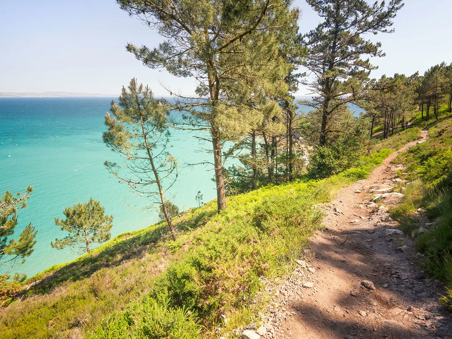
Most of the walking is on the GR34 Sentier des Douaniers: narrow dirt and rocky single-track across heath-clad headlands, with sections through pine, scrub and sunken lanes. The waymarking is a major advantage, but the path still demands attention where the line is rocky, eroded or close to the cliff edge.
After rain, expect slippery rock, greasy mud and wet vegetation. Brittany’s fine Atlantic drizzle, the crachin, can soak the surface without making the weather feel dramatic, so grip matters even on mild days.
Sandy sections occur around beaches including Plage de Kersiguénou, Plage de Goulien, Plage de la Palue, Morgat and Plage de Trez-Bellec. These can slow progress, especially at the end of a long day, and beach diversions can alter the exact distance walked.
Exposure and cliff-edge walking
The most serious terrain issue is exposure rather than technical scrambling. The clifftop path is often narrow and the edges are exposed and unfenced, particularly around the major headlands such as Pointe de Pen-Hir, Pointe de Dinan and Cap de la Chèvre.
In dry, calm weather these sections are straightforward for sure-footed walkers. In strong wind, drizzle or poor visibility they require more caution, especially where the path runs above steep drops or crosses rocky ground near viewpoints.
Do not rely on fences or barriers to define safe ground. Stay on the marked GR34 line and give cliff edges a wide berth, particularly when stepping aside for other walkers or stopping for photographs.
Climbs, descents and daily effort
The climbing is rarely long, but it is persistent. The path repeatedly drops towards beaches, coves and stream-cut gullies, then climbs back to the headlands.
This switchback pattern is most tiring with a full pack and in warm or windy conditions. A 20–24 km day here can feel harder than the distance suggests because the rhythm is constantly interrupted by short steep pulls and careful descents.
| Section | Practical terrain character |
|---|---|
| Camaret-sur-Mer to Plage de Goulien | Clifftop GR34 walking out past Pointe du Toulinguet and Pointe de Pen-Hir, with exposed headland sections and descents towards beaches. |
| Plage de Goulien to Saint-Hernot / Morgat | One of the rougher-feeling stretches, taking in Pointe de Dinan, Plage de la Palue, Pointe de Rostudel and Cap de la Chèvre. Expect repeated climbing, open heath and Atlantic exposure. |
| Saint-Hernot / Morgat to Telgruc-sur-Mer | More varied walking via Morgat, Île de l’Aber, Pointe du Bellec and Plage de Trez-Bellec, mixing coast path, beach approaches and settlement/resort sections. |
Road walking, lanes and settlements
This is primarily a coastal footpath, not a road walk. Shorter paved or lane sections are most likely around Camaret-sur-Mer, Morgat, Crozon-side access points and Telgruc-sur-Mer, where the GR links harbours, beaches, services and accommodation.
Sunken lanes form part of the terrain mix and can be muddy or enclosed after rain. They are generally not technically difficult, but they can feel slower than open clifftop walking if wet underfoot.
Mud, bogginess and wet-weather pace
The route should not be thought of as a boggy upland trail, but wet ground is still a real factor. Dirt tracks, shaded lanes, vegetated cliff paths and rocky descents can all become slippery after rain.
Waterproof footwear with good tread is more useful than heavy mountain boots for most walkers. Trail shoes can work in dry conditions for experienced hikers, but smooth-soled footwear is a poor choice on wet rock, sandy descents and muddy path edges.
Poles are optional rather than essential, but they can help on repeated descents and on wet, uneven ground. They are less useful where the path is very narrow or rocky and hands are better kept free for balance.
Beaches, coves and tides
The GR34 uses the coast but does not make this a simple shoreline walk. The main line repeatedly climbs away from beaches onto the cliffs, and some beach or cove visits are side diversions rather than the easiest through-route.
Access around Île de l’Aber and Plage de l’Île Vierge can be tide-sensitive. Tide times should be checked before travelling if planning to leave the main path to explore these places.
The wild west-facing beaches such as Plage de la Palue and Plage de Goulien are known for strong currents. They are better treated as scenic rest stops than guaranteed swimming places; swimming can be dangerous or unsupervised.
Seasonal conditions
Spring usually offers good walking conditions, but expect wet spells and slippery ground after rain. Vegetation can make narrow paths feel more enclosed, and wind on the headlands can still be cold.
Summer brings the easiest daylight and the busiest accommodation period. Heat is usually less of a problem than on inland or southern European routes, but exposed headlands provide little shelter from sun, wind or sudden drizzle, and water/resupply gaps still need planning.
Autumn can be excellent, with fewer people and cooler walking temperatures, but Atlantic wind and rain become more influential. Shorter daylight makes the 22–24 km stages less forgiving if progress is slowed by mud, wind or route-finding checks.
What makes it easier or harder in practice
The route is easier when walked with a light pack, booked accommodation, reliable weather and enough food and water between towns. Morgat is the main midway resupply stop, so do not assume frequent services on the headland sections.
It becomes harder in wet or windy weather, with a heavy pack, late starts or tight accommodation plans that force long days. The path is well waymarked, but exposed clifftop walking still needs conservative decisions when visibility, wind or footing deteriorate.
This is a moderate coastal GR rather than a technical mountain route. Reasonably fit walkers should find it manageable, but only if the repeated climbs, slippery surfaces and Atlantic exposure are treated as the real challenge.
Weather and Best Time to Walk
The best walking window for the Presqu’île de Crozon Trail is spring to autumn, with late spring and early autumn usually the most practical balance: long enough days, less pressure on accommodation than high summer, and generally workable conditions on the clifftop path.
This is a low-level coastal route, but it is not sheltered. The main weather issues are Atlantic wind, drizzle (crachin), rain-softened ground and exposed headlands, rather than altitude or cold. The path repeatedly climbs and drops between beaches and cliff tops, so wet rock, mud and sandy descents can slow the day considerably.
Season by season
| Season | What to expect | Planning implications |
|---|---|---|
| Spring | Often a good time to walk, with fresh conditions and enough daylight for the 3-day itinerary. Rain and Atlantic wind remain likely. | Carry full waterproofs and use footwear with reliable grip. Accommodation should still be booked rather than assumed, especially around Camaret-sur-Mer, Morgat and Telgruc-sur-Mer. |
| Summer | The most popular period, with the easiest logistics but the greatest pressure on beds and campsites. Exposed headlands can still be windy, and drizzle is possible even in otherwise settled weather. | Book well ahead. Start early on longer days, especially the 22–24 km stages, and carry enough water and food between towns. Do not rely on swimming at Plage de la Palue or Plage de Goulien: these wild Atlantic beaches are known for strong currents and may be dangerous or unsupervised. |
| Autumn | A strong option for quieter walking, but conditions become more changeable. Rain can make the narrow clifftop path slippery, and wind exposure matters more on Pointe de Pen-Hir, Pointe de Dinan and Cap de la Chèvre. | Allow realistic timings and avoid pushing late into the day as daylight shortens. Check accommodation and transport before committing to dates. |
| Winter | Not the normal season for this route. The path is low and snow is not the usual concern, but short days, Atlantic storms, wet ground and exposed, unfenced cliff edges make it a poor choice for a relaxed first crossing. | Only suitable for well-equipped walkers who can be flexible with dates and turn back in bad weather. Accommodation, food and bus options should be checked before travelling. |
Wind, rain and exposed cliffs
Treat wind as a route condition, not just a comfort issue. Much of the GR34 here follows narrow coastal ground above the sea, with exposed and sometimes unfenced edges. In strong winds or stormy weather, the headlands around Pointe de Pen-Hir, Pointe de Dinan and Cap de la Chèvre deserve particular caution.
Rain affects the trail quickly. The surface alternates between dirt, rock, sand, sunken lanes and scrubby coastal path; after wet weather it can become muddy or slick, especially on short descents to beaches and coves. Walking poles can be useful for balance, but good footwear matters more.
Daylight and stage timing
The standard itinerary has three fairly full walking days, including stages of around 22 km and 24 km. In spring and autumn, shorter daylight means an early start is sensible, particularly if staying away from the main hubs or if weather slows progress.
Do not judge the route by its high point of roughly 100 m. The total ascent is about 1,040 m because the path constantly rises and falls between beaches, coves and clifftops. Wet ground and headwinds can make those repeated climbs feel much harder than the map profile suggests.
Accommodation and seasonal pressure
Summer is the critical booking season. Accommodation is concentrated in Camaret-sur-Mer, Crozon, Morgat and Telgruc-sur-Mer, with fewer options between towns, so beds should be reserved well ahead.
Outside peak season, the issue is less crowding and more availability. Hotels, guesthouses, gîtes, campsites, food stops and local transport should be checked before travelling, especially if splitting the route at smaller places such as the Goulien area or Saint-Hernot.
Weather kit to prioritise
Pack for changeable Atlantic conditions even on a short 3-day walk. A waterproof jacket, pack cover or liner, warm layer, grippy footwear and sun protection are all sensible in the main walking season.
Because resupply is limited between towns and Morgat is the main midway stop, carry enough food and water for the day rather than depending on beach cafés or small seasonal services being open. This should be checked before travelling.
Safety Notes
Emergency help
In France, call 112 for emergency assistance. Give the nearest named place or landmark where possible: useful reference points on this route include Camaret-sur-Mer, Pointe de Pen-Hir, Pointe de Dinan, Cap de la Chèvre, Saint-Hernot, Morgat, Île de l’Aber, Plage de Trez-Bellec and Telgruc-sur-Mer.
Mobile reception should not be relied on continuously along the clifftops, coves and more remote headlands. Carry an offline map or paper map, keep enough battery in reserve, and make sure someone knows the day’s planned finish if walking alone.
Cliffs, narrow path and slippery ground
The main route hazard is the coastal path itself: narrow dirt and rocky single-track, often close to exposed and unfenced cliff edges. Stay on the marked GR34 line, especially around Pointe de Pen-Hir, Pointe de Dinan and Cap de la Chèvre, where the cliffs and headlands are the attraction but also the risk.
After rain, the path can be muddy, sandy or greasy on rock. Short descents to beaches and coves can be particularly slippery, so footwear with good grip matters more here than the modest altitude suggests.
Weather exposure
This is a low route, but it is very exposed to Atlantic weather. Wind, drizzle and sudden changes in visibility can make the clifftop sections feel more serious, particularly on open headlands between Camaret-sur-Mer and Morgat.
Carry waterproofs even in settled seasons, and add a warm layer for wind chill on the capes. In hot, bright weather there is also little shade on the heath and cliff sections, so carry enough water, sun protection and a hat.
Beaches, currents and tide checks
The wild west-facing beaches, especially Plage de la Palue and Plage de Goulien, are known for strong currents and can be dangerous or unsupervised for swimming. Treat them as walking stops rather than safe bathing places unless local lifeguard information clearly says otherwise.
Check tide times before relying on access around Île de l’Aber or making side visits to Plage de l’Île Vierge. Do not cross tidal ground unless there is a clear, safe return window.
Remote sections and resupply
There are stretches with limited services between the main settlements, and Morgat is the key midway resupply stop. Start each day with enough water and food for the full stage, not just to the next beach or headland.
If accommodation is away from the GR34, allow time and energy for the access walk or bus transfer. The peninsula has no railway, and bus times can affect escape options from Camaret-sur-Mer, Crozon, Morgat and Telgruc-sur-Mer; current BreizhGo timetables should be checked before travelling.
Roads, villages and livestock
Road walking is not the defining hazard on this route, but short linking sections around villages, accommodation and access points still need care. Use pavements where available and be visible in poor weather or fading light.
Livestock is not a major route-specific issue on this coastal section. If animals are encountered on grazed headland or farmland edges, keep distance, close gates where present, and do not approach young animals.
Solo walking
This is a realistic solo hike for a competent walker, but the exposed cliff path makes conservative decisions important. Avoid late starts, do not push on in deteriorating weather just to keep to a schedule, and turn inland or use transport if conditions become unsafe.
A solo walker should carry a charged phone, offline mapping, waterproofs, a warm layer, water, food, a small first-aid kit and a headtorch. On a three-day itinerary, also keep bus and accommodation details accessible offline.
Daily checks before setting off
Before each stage, check:
- The day’s weather forecast, especially wind, rain and visibility.
- Tide times if visiting Île de l’Aber or Plage de l’Île Vierge.
- Any local clifftop diversions or path closures.
- Water and food for the whole stage, particularly outside Camaret-sur-Mer, Morgat and Telgruc-sur-Mer.
- BreizhGo bus times if using public transport as a start, finish or fallback option.
- Accommodation check-in arrangements, especially in summer when beds are limited.
- Phone battery, offline maps and the next reliable named place on the route.
Gear Recommendations
The Presqu’île de Crozon Trail is low in altitude, but it is not a trainer-and-daypack coastal stroll. The route is a repeated sequence of short climbs and descents on narrow clifftop path, rocky single-track, sandy beach approaches and muddy sections after rain, with Atlantic wind and drizzle possible in any walking season.
Pack for grip, weather protection and self-sufficiency between towns rather than for mountain height. Morgat is the main midway resupply point, and services are more limited between Camaret-sur-Mer, the Goulien / La Palue coast, Saint-Hernot and Telgruc-sur-Mer.
Footwear
Wear grippy walking shoes or lightweight boots with a good tread. The path is often rocky, sandy or slippery after rain, and the repeated short descents onto beaches and coves are more demanding on feet than the modest altitude suggests.
Waterproof footwear is useful in spring and autumn, and after wet weather, but breathability matters in summer. Avoid smooth-soled road shoes: they are poorly suited to wet rock, muddy sunken lanes and exposed clifftop paths.
Gaiters are optional. They can be helpful in wet grass, mud and sandy approaches to beaches such as Plage de Goulien, Plage de la Palue and Trez-Bellec, but most walkers will not need heavy mountain gaiters.
Waterproofs and warm layers
A reliable waterproof jacket is essential in all seasons. Brittany’s crachin can turn a dry-looking day damp quickly, and exposed headlands such as Pointe de Pen-Hir, Pointe de Dinan and Cap de la Chèvre can feel cold in wind even when the walking height is only around 70–100 m.
Waterproof trousers are strongly recommended outside settled summer weather. They are also useful if the path is wet and vegetation brushes the legs for long stretches.
Carry a warm layer even on a mild forecast. A fleece or light insulated layer is enough for most walkers, but it should be easy to reach for rest stops, bus waits and exposed viewpoints.
Navigation
The route follows the GR34 red-and-white waymarks, so navigation is generally straightforward. A phone mapping app with the route downloaded offline is still worth carrying, especially around beach approaches, village exits and any temporary clifftop diversions.
The recommended paper map for the peninsula is IGN TOP 25 0417ET, Presqu’île de Crozon. A paper map is particularly useful if walking in poor visibility, if a phone battery fails, or if using bus links to shorten a day.
Carry enough battery for a full day of navigation and photos. A small power bank is sensible for anyone using a phone as the main map, especially on the longer days between Plage de Goulien, Cap de la Chèvre, Morgat and Telgruc-sur-Mer.
Water and food carry
Do not rely on frequent shops or cafés between the main settlements. Camaret-sur-Mer, Morgat, Crozon and Telgruc-sur-Mer are the key service points, with Morgat the most important midway resupply stop.
Most walkers should start each day with enough water for several hours of exposed coast walking. Capacity of around 1.5–2 litres is a sensible baseline in moderate conditions; carry more in hot summer weather or if unsure where the next reliable refill will be.
Pack lunch and snacks before leaving town, particularly for the central headland stages around Plage de la Palue, Pointe de Rostudel and Cap de la Chèvre. A compact emergency snack is worthwhile in case weather, photography stops or a missed bus makes the day longer than planned.
Trekking poles
Trekking poles are useful but not essential. They help on the repeated steep little climbs and descents, and they add stability on muddy or sandy sections after rain.
Use poles carefully on narrow clifftop path and around other walkers. On very rocky or constricted sections, it may be easier to stow them briefly.
Sun, wind and insect protection
The route is exposed to Atlantic weather for much of its length. Sunglasses, sun cream and a brimmed cap are useful in summer, especially where the path crosses open heath and reflective beach sections.
A buff or light hat is helpful in wind on the headlands. Insect protection is not a defining issue on this coastal route, but a small repellent can be worthwhile in still, warm conditions around scrub or campsites.
For inn-to-inn hikers
Inn-to-inn walkers should keep the pack light. A 20–30 litre daypack is usually enough if accommodation is booked in Camaret-sur-Mer, the Goulien / Morgat area and Telgruc-sur-Mer, and if luggage transfer is not being used.
Prioritise waterproofs, a warm layer, water, food, navigation, phone power and a small first-aid kit. Evening clothes should be minimal: every unnecessary kilogram is felt on the constant switchbacks of the GR34.
Accommodation is concentrated in the towns and main resort areas, and beds are thin between them. Booking ahead is particularly important in summer; do not carry less safety gear simply because the route passes popular coastal places.
For campers
Camping kit must be compact and weather-resistant. Atlantic wind and rain are realistic considerations even in the main walking season, so a stable lightweight tent, warm sleeping bag and reliable waterproof packing are more useful than ultra-minimal fair-weather gear.
Wild camping is restricted, with bivouac tolerated only in places. Plan around official campsites or booked accommodation where possible, and check local rules before relying on a bivouac.
A stove, food and extra water capacity may be needed if camping away from the main service hubs. Keep the total pack weight under control: the trail’s short climbs and descents are tiring with a heavy load, despite the low high point.
For fast and section hikers
Fast walkers and section hikers can use the BreizhGo bus links between Camaret-sur-Mer, Crozon, Morgat and Telgruc-sur-Mer to shorten or split the route. Current timetables should be checked before travelling, as missed connections can leave a long wait.
A smaller running-style pack is suitable only if it still carries waterproofs, warm layer, water, food, phone, power bank and basic first aid. The coastal path is narrow, rocky and exposed in places, so speed should not come at the expense of grip or weather protection.
If moving quickly, allow for delays on wet rock, steep beach descents and busy viewpoints such as Pointe de Pen-Hir and Cap de la Chèvre. Lightweight kit is helpful; underprepared kit is not.
Budget and Costs
Costs on the Presqu’île de Crozon Trail are driven mainly by where you sleep. The walking itself has no route fee, and the GR34 is a waymarked public trail, but accommodation is limited between Camaret-sur-Mer, Crozon, Morgat and Telgruc-sur-Mer, so summer prices and availability can change quickly. Check current prices before booking.
Main cost factors
| Cost | What to expect | Planning advice |
|---|---|---|
| Accommodation | Hotels, chambres d’hôtes, gîtes/hostels and campsites are the relevant options on this section. Beds are concentrated in Camaret-sur-Mer, Crozon, Morgat and Telgruc-sur-Mer. | Book well ahead in summer, especially if relying on a fixed 3-day itinerary. Plage de Goulien and Saint-Hernot/Morgat are practical staging areas, but options are thinner away from the main towns. |
| Food and drink | Camaret-sur-Mer, Crozon, Morgat and Telgruc-sur-Mer are the key places for meals and supplies; Morgat is the main midway resupply stop. | Carry lunch and snacks for the cliff sections, especially between beaches and headlands where there may be no reliable shop or café. Opening days and seasonal hours should be checked locally. |
| Transport | The peninsula has no railway. Access is by BreizhGo coach from Brest or Quimper, with lines 34/934 and 37/937 linking the peninsula, including Camaret, Crozon, Morgat and Telgruc. | Check current BreizhGo timetables before travelling, especially for weekends, holidays and out-of-season journeys. |
| Local taxis | Useful if bus times do not match the start or finish, or if shortening a stage from Morgat, Crozon or Telgruc-sur-Mer. | Pre-book where possible and confirm the fare before travelling. Availability can be limited outside the main towns. |
| Campsites | Camping can reduce costs where sites fit the stage plan. Wild camping is restricted, with bivouac tolerated only in some places. | Do not assume camping is possible on clifftops or beaches. Use official sites where available and check current opening dates. |
| Luggage transfer | Relevant for walkers booking through an organised self-guided itinerary, or arranging private support locally. | Availability and prices vary by operator and season. Check before committing to accommodation that depends on bag transfer. |
| Guided or self-guided packages | Some operators sell Crozon/GR34 itineraries with accommodation booking and route notes, usually over similar 3-day stage lengths. | More expensive than arranging the walk independently, but useful when beds are scarce or when luggage transfer is required. Confirm exactly which route variant is included. |
Budget approach
A low-cost trip depends on using campsites, gîtes or simple rooms, carrying supermarket food where possible, and using BreizhGo buses rather than taxis. This is easiest outside the busiest summer weeks and only if accommodation lines up with the stage distances.
Do not rely on wild camping as the budget solution. Restrictions apply, and the route crosses exposed clifftop and beach areas where camping may be unsuitable or prohibited.
Mid-range approach
Most independent walkers should budget for a mix of modest hotels, chambres d’hôtes or gîtes, with evening meals in Camaret-sur-Mer, Morgat/Crozon or Telgruc-sur-Mer and packed lunches for the trail. This is the most practical balance for the classic 3-day walk.
Accommodation should be booked before transport, because the stage plan is controlled by where beds are available. If the preferred stop near Plage de Goulien or Saint-Hernot is not workable, staying in or near Morgat/Crozon may be more practical, with a bus or taxi adjustment if needed.
Comfortable approach
A more comfortable trip usually means private rooms, restaurant meals, possible taxi transfers and, if available, luggage transfer through a self-guided package. This reduces daily logistics but needs early booking, particularly in summer when beds on the peninsula are limited.
Self-guided packages can be worthwhile for walkers who want accommodation, route notes and luggage movement handled together. Check current package prices, what meals are included, whether transport to Camaret-sur-Mer or from Telgruc-sur-Mer is included, and whether the itinerary follows this shorter southern-coast highlight section rather than the longer full Crozon loop.
Where to be careful with costs
The biggest false economy is booking cheap accommodation far from the GR34 without a reliable way to get back to the path. The peninsula’s bus network is useful, but services must fit the walking day; otherwise a taxi may cancel out the saving.
The second risk is underestimating food logistics. Between the main settlements, the route spends long stretches on headlands, beaches and clifftop path, so a paid café lunch cannot be assumed. Carrying food from Camaret-sur-Mer, Morgat or Crozon is often the safer plan.
For all prices — accommodation, campsites, buses, taxis, luggage transfer and packages — check current rates before booking.
Luggage Transfer, Guided Tours and Support Services
Luggage transfer
Do not assume there is a simple daily bag-courier system covering every overnight stop on this 3-day section. The route uses small coastal places and accommodation clusters around Camaret-sur-Mer, the Goulien area, Saint-Hernot/Morgat and Telgruc-sur-Mer, so luggage movement is best arranged before booking rather than improvised on arrival.
The easiest way to walk with a light daypack is to book a self-guided package that includes baggage transfers, or to ask each accommodation whether it can help arrange onward luggage transport. If using chambres d’hôtes, gîtes or campsites rather than hotels, check this explicitly before paying a deposit.
Independent walkers should be prepared to carry everything needed for the 3 days. A lightweight backpack is realistic on this route, but the repeated short climbs, rocky clifftop sections and Atlantic weather make overpacking unpleasant.
Self-guided walking packages
Self-guided packages are the most practical support option for walkers who want the GR34 experience without handling every accommodation and transfer detail. Specialist operators such as Prêt pour l’Aventure list Camaret-sur-Mer to Telgruc-sur-Mer itineraries on this section, with distances broadly matching the 3-day route.
A typical self-guided arrangement may include pre-booked accommodation, luggage transfer, route notes or mapping support, and local contact assistance. Exact inclusions, start dates, baggage limits and prices vary, so current details should be checked when booking.
This option suits walkers travelling in summer, when beds are thin and advance booking matters, or anyone who does not want to carry a full pack on the narrow coastal path. It is less necessary for confident walkers travelling light outside the busiest periods, provided accommodation and transport are organised well ahead.
Guided walking
A fully guided trip is not essential for navigation: this is a waymarked GR34 section with red-and-white blazes. The main challenges are fitness, exposed weather, slippery ground after rain and managing food, water and overnight stops between the main settlements.
A guide can still be useful for groups, first-time multi-day walkers, or anyone wanting local interpretation of the headlands, coastal history and protected landscape of the Parc naturel régional d’Armorique. Availability is likely to be seasonal and should be arranged in advance through walking-holiday companies or local tourism contacts.
Taxi transfers and public-transport support
Local taxis can be useful for luggage moves, accommodation shuttles, bad-weather exit plans or linking an overnight stay away from the GR34. They should be booked ahead, especially in summer and for early-morning or evening transfers. This should be checked before travelling.
Public transport is more predictable for planned starts and finishes. The peninsula has no railway, but BreizhGo coaches link the area with Brest and Quimper, and lines 34/934 and 37/937 serve key places including Camaret-sur-Mer, Crozon, Morgat and Telgruc-sur-Mer. On-demand transport is available for smaller villages, but current BreizhGo timetables and booking rules should be checked before travelling.
For section-hiking, the bus network can help shorten a day or return to a base in Crozon, Morgat, Camaret-sur-Mer or Telgruc-sur-Mer. Do not rely on being able to bail out from every headland or beach: between settlements the path is often remote, exposed and away from regular services.
What to book ahead
- Accommodation: essential in summer, especially in Camaret-sur-Mer, Morgat and Telgruc-sur-Mer.
- Luggage transfer: arrange before committing to accommodation; do not assume every host can move bags.
- Taxi transfers: book in advance for luggage, off-route accommodation or fixed train/bus connections.
- Self-guided packages: reserve early for peak-season dates and check exactly what is included.
- BreizhGo buses and on-demand transport: check current timetables before travelling, particularly for weekends, holidays and onward connections to Brest or Quimper.
Shorter Hikes and Best Sections
The Presqu’île de Crozon section of the GR34 is easy to shorten in principle, but not every beach or headland has simple public transport. The most practical section walks start or finish in Camaret-sur-Mer, Morgat, Crozon or Telgruc-sur-Mer, where BreizhGo buses and accommodation are more realistic.
For anything ending at Plage de Goulien, Plage de la Palue, Saint-Hernot or a headland car park, plan the exit before setting off. Taxis, on-demand transport or a lift may be needed, and current BreizhGo timetables should be checked before travelling.
| Best for | Start → end | Approx. distance | Why choose it | Transport notes |
|---|---|---|---|---|
| Best single full day | Camaret-sur-Mer → Plage de Goulien | ~17 km | A strong first taste of the route: Camaret harbour, the Tour Vauban, Pointe du Toulinguet, Pointe de Pen-Hir, the Tas de Pois and the west-facing beaches around Kersiguénou and Goulien. | Camaret-sur-Mer is linked by BreizhGo from Brest and Quimper via the peninsula. The finish at Plage de Goulien is less straightforward; arrange onward transport in advance or be prepared to walk out to a served settlement. This should be checked before travelling. |
| Best scenery | Plage de Goulien → Saint-Hernot / Morgat | ~22 km | The wildest-feeling middle section: Pointe de Dinan and the “Château de Dinan”, Plage de la Palue, Pointe de Rostudel, Cap de la Chèvre and the descent towards Plage de l’Île Vierge and Morgat. It is the best choice if the priority is cliffs, Atlantic exposure and headlands. | Morgat is the practical end point because it has services and bus links via the Crozon area. Starting at Plage de Goulien normally needs a pre-arranged drop-off, taxi or on-demand transport. |
| Best weekend | Camaret-sur-Mer → Saint-Hernot / Morgat | ~39 km over 2 days | Combines the classic Pen-Hir coastline with the wilder Dinan–Cap de la Chèvre section. It gives a substantial GR34 experience without committing to the full Camaret–Telgruc traverse. | Camaret-sur-Mer and Morgat are the useful transport points. The overnight around the Goulien area must be planned carefully, as beds and services are thin between the main towns and can book out in summer. |
| Best 3-day section | Camaret-sur-Mer → Telgruc-sur-Mer | ~60 km | The complete southern-coast highlight section is still the best use of three days: Pen-Hir, Dinan, Cap de la Chèvre, Morgat, Île de l’Aber and Trez-Bellec all fall into one continuous traverse. | Both ends are on the peninsula bus network, with access from Brest or Quimper. This is the cleanest public-transport itinerary because it avoids needing to return to the start by car. |
| Best for beginners | Camaret-sur-Mer out-and-back towards Pointe de Pen-Hir / Tas de Pois | Variable half-day or day walk | Good for walkers who want the scenery without a committing point-to-point stage. Turn back before fatigue, bad weather or exposed ground becomes a problem. The path is waymarked, but the clifftops are still narrow, rocky and exposed. | Camaret-sur-Mer is the simplest base for this option. Use it as a there-and-back walk unless onward transport from the coast has been arranged. |
| Best for public transport | Morgat → Telgruc-sur-Mer | ~24 km | A practical final-day section with a clear start and finish, avoiding the more awkward access points around Goulien and la Palue. It still gives beach, cove and bay walking via Île de l’Aber, Pointe du Bellec and Plage de Trez-Bellec. | Morgat and Telgruc-sur-Mer are linked by the peninsula bus network, but services are not metro-style frequent. Check the day’s BreizhGo timetable before committing to a one-day walk. |
| Best for villages and accommodation | Camaret-sur-Mer → Morgat, with Crozon as the inland hub | ~39 km over 2 days | Best where beds, meals and resupply matter more than wilderness. Camaret-sur-Mer and Morgat are the main coastal bases, while Crozon is the inland hub for services and onward transport. | Book accommodation well ahead in summer. If nothing suitable is available near the Goulien area, a transfer to/from Crozon or Morgat may be more practical than forcing the stage. |
| Best camping-based option | Use Camaret-sur-Mer, Morgat/Crozon or Telgruc-sur-Mer as bases | Variable | Camping works best when planned around formal campsites and established settlements rather than improvised clifftop stops. Wild camping is restricted, and bivouac is tolerated only in places. | Do not rely on finding a legal pitch on the headlands or beaches. Check current campsite availability before travelling, especially in July and August. |
Highlights and Points of Interest
This section of the GR34 is built around a sequence of Atlantic headlands, exposed beaches and small coastal settlements. The best places to allow extra time are Camaret-sur-Mer, Pointe de Pen-Hir, Pointe de Dinan, Cap de la Chèvre, Morgat and the final approach around Île de l’Aber and Trez-Bellec.
Camaret-sur-Mer and the Tour Vauban
Camaret-sur-Mer is more than a convenient start point. The fishing port has one of the route’s strongest historic settings, with the late-1600s Tour Vauban, known as the Tour Dorée, guarding the harbour.
The tower is part of the UNESCO World Heritage Fortifications of Vauban. Beside the harbour, the ruined Chapelle Notre-Dame-de-Rocamadour adds another worthwhile stop before following the GR34 red-and-white waymarks out towards the open coast.
Pointe du Toulinguet and Pointe de Pen-Hir
The first major headlands west of Camaret give an immediate sense of the terrain: narrow coastal path, exposed clifftops and repeated short climbs rather than high mountains. Pointe du Toulinguet leads towards the more famous Pointe de Pen-Hir, one of the signature viewpoints of the Presqu’île de Crozon.
Pointe de Pen-Hir is best known for the Tas de Pois, the line of offshore sea stacks below the cliffs. In clear weather, views can extend towards Ouessant and the Pointe du Raz, making this one of the places most worth lingering if conditions are good.
Plage de Goulien and Plage de la Palue
Plage de Goulien and Plage de la Palue are long, wild Atlantic beaches below the clifftop path. They give a striking contrast to the headlands: open sand, surf and broad west-facing views.
Both beaches are popular with surfers, but they are not casual swimming stops. Strong currents can make bathing dangerous, and swimming may be unsupervised, so treat them as scenic rest points rather than reliable places for a dip.
Pointe de Dinan and the Château de Dinan
Pointe de Dinan is one of the most distinctive natural landmarks on the route. Its detached rock mass, linked to the cliff by a natural arch, is known as the Château de Dinan because of its castle-like shape.
This is a good place to build in extra time on the second stage, especially if visibility is clear. The path around the headland is exposed, so keep away from cliff edges in wind, drizzle or poor visibility.
Cap de la Chèvre
Cap de la Chèvre forms the wild southern tip of the peninsula and is one of the route’s major turning points. The landscape here is heath-covered and open, with wide views across the Baie de Douarnenez and the Iroise Sea.
The French Navy semaphore station underlines the strategic position of this coast on the approaches to Brest. This is also a practical mental checkpoint: beyond the cape, the route begins to turn towards Saint-Hernot and Morgat.
Saint-Hernot and Plage de l’Île Vierge
Near Saint-Hernot, the route passes close to the Maison des Minéraux before descending towards the celebrated Plage de l’Île Vierge. The cove is known for its turquoise water and is one of the most photographed natural features on the Crozon coast.
Access around Plage de l’Île Vierge should be treated carefully, particularly with tide and path conditions. Tide times and any local access advice should be checked before travelling.
Morgat
Morgat is the main midway resupply stop on this highlight section. It has a long sandy beach, a marina and a more sheltered feel than the exposed western headlands.
It is also known for the Grottes de Morgat, sea caves reached by boat. For walkers, Morgat is the best place on the route to pause, restock and reset before the final section towards Telgruc-sur-Mer.
Île de l’Aber, Pointe du Bellec and Trez-Bellec
The final approach towards Telgruc-sur-Mer shifts the mood again, with the Baie de Douarnenez opening south. Île de l’Aber is a tidal islet topped by old fortifications, giving a final historic landmark before the route continues towards Pointe du Bellec and Plage de Trez-Bellec.
Trez-Bellec is a quieter beach stop near the end of the walk. If planning to explore around Île de l’Aber, tide times should be checked before travelling.
The GR34 itself: the Sentier des Douaniers
One of the route’s main points of interest is the path itself. The GR34 follows the historic Sentier des Douaniers, the customs officers’ path created to patrol the Breton coast and later revived as Brittany’s long-distance coastal trail.
On this section, that history translates into practical walking: the trail hugs the edge of the land wherever possible, linking watchful headlands, beaches, coves and harbour towns. The result is near-continuous coastal walking, but also frequent short climbs, exposed corners and slippery ground after rain.
Common Mistakes and Planning Tips
The Presqu’île de Crozon Trail is straightforward to follow, but it is easy to mis-plan. The main problems are not technical terrain; they are accommodation gaps, exposed weather, short-but-relentless climbs, limited resupply and the fact that the peninsula has no railway.
1. Treating the route as an easy beach walk
Mistake: Looking at the low high point of roughly 100 m and assuming the walking will be flat and fast.
Fix: Plan for a constant coastal switchback: short steep climbs out of coves, rocky clifftop path, sandy sections, muddy ground after rain and exposed headlands. The total ascent is about 1,040 m over the 3-day section, which is enough to slow a heavily loaded walker. Build in time for Pointe de Pen-Hir, Pointe de Dinan and Cap de la Chèvre rather than trying to race the stages.
2. Confusing this 3-day trail with the full Crozon loop
Mistake: Booking transport or accommodation for a longer Tour de la presqu’île de Crozon itinerary, then realising the route on this page is the shorter southern-coast highlight section between Camaret-sur-Mer and Telgruc-sur-Mer.
Fix: Check that every booking matches the intended point-to-point route: Camaret-sur-Mer, Plage de Goulien area, Saint-Hernot or Morgat, then Telgruc-sur-Mer. The longer peninsula circuits also use the Rade de Brest side via places such as Roscanvel, Le Fret and Landévennec; those are not part of this 3-day southern-coast section unless an extra day has deliberately been added.
3. Leaving accommodation too late in summer
Mistake: Assuming a popular GR34 coastal stage will always have spare beds on arrival.
Fix: Book ahead, especially in summer. Accommodation is concentrated in Camaret-sur-Mer, Crozon, Morgat and Telgruc-sur-Mer, with thinner options between the main settlements. If using a stage ending around Plage de Goulien or Saint-Hernot, check exactly where the night’s accommodation is and whether any extra walking or transfer is needed.
Wild camping should not be used as a back-up plan. It is restricted, with bivouac tolerated only in some places, so walkers relying on camping need to check local rules and campsite availability before committing to stages.
4. Assuming every beach or hamlet has food and water
Mistake: Treating names such as Plage de Goulien, Plage de la Palue or Pointe de Dinan as service points.
Fix: Carry enough food and water for the walking day, and do not count on beach locations or headlands for resupply. Morgat is the main midway resupply stop on the classic route, with larger services inland at Crozon. Opening times can be seasonal and may be limited outside the main holiday period; this should be checked before travelling.
5. Underestimating the final-day logistics
Mistake: Reaching Telgruc-sur-Mer and only then working out how to leave the peninsula.
Fix: Plan the exit before booking the hike. The peninsula has no railway, so public transport depends on BreizhGo coaches: line 34/934 links Brest, Crozon, Telgruc and Camaret, and line 37/937 connects Quimper with Camaret. Current BreizhGo timetables should be checked before travelling, especially for weekends, public holidays and shoulder-season trips.
If walking in reverse from Telgruc-sur-Mer to Camaret-sur-Mer, apply the same logic to the start. Do not assume a late arrival by train in Brest or Quimper will connect neatly with a bus to the peninsula.
6. Relying only on GR waymarks
Mistake: Assuming the red-and-white GR34 blazes are enough in all conditions.
Fix: Use the waymarks, but carry an independent map or offline navigation as well. The recommended map for the peninsula is IGN TOP 25 0417ET, and offline mapping is useful where paths braid around beaches, car parks, headlands or temporary diversions.
Clifftop paths can be rerouted after erosion, storms or maintenance. If using a GPX file, make sure it follows the current GR34 line and be ready to obey local diversion signs on the ground.
7. Ignoring Atlantic weather on exposed headlands
Mistake: Packing for a mild seaside walk and leaving proper waterproofs or wind protection behind.
Fix: Expect Atlantic wind and crachin, the fine Breton drizzle that can make rock, mud and wooden steps slippery. A waterproof jacket, warm layer and footwear with good grip are more useful than lightweight town shoes. The most exposed sections around Pointe de Pen-Hir, Pointe de Dinan and Cap de la Chèvre deserve particular attention in poor weather.
Forecasts should be checked each evening, not just before leaving home. In strong wind, stay well back from unfenced cliff edges and avoid stepping onto exposed viewpoints simply for photographs.
8. Planning stages that are too ambitious
Mistake: Measuring the day only by kilometres and ignoring terrain, weather and sightseeing stops.
Fix: Keep the classic 3-day structure realistic: around 17 km from Camaret-sur-Mer to Plage de Goulien, around 22 km to Saint-Hernot or Morgat, and around 24 km to Telgruc-sur-Mer. These are not Alpine distances, but they include repeated climbing and descending. In poor weather or with a heavy pack, the second and third days can feel longer than their map distance suggests.
Walkers wanting shorter days should look at splitting stages through accommodation in or near the main settlements. Availability, transport and transfers should be checked before booking, because services are not evenly spaced along the coast.
9. Treating wild beaches as safe swimming stops
Mistake: Planning long lunch swims at Plage de la Palue or Plage de Goulien without considering conditions.
Fix: Treat the west-facing beaches as wild Atlantic beaches first and bathing beaches second. Plage de la Palue and Plage de Goulien are known for strong currents, and swimming can be dangerous or unsupervised. Follow local safety signs and do not enter the water if conditions are uncertain.
10. Forgetting tide-sensitive side visits
Mistake: Assuming every cove, islet or beach access is available whenever the route passes nearby.
Fix: Check tide times before relying on access to places such as Île de l’Aber or Plage de l’Île Vierge. The main GR34 walking line should still be planned as a coastal footpath, but side visits and low-level beach access can be affected by the tide. This should be checked before travelling.
11. Booking the wrong end of a split stage
Mistake: Seeing Saint-Hernot, Morgat and Crozon as interchangeable on a booking screen.
Fix: Check the exact location against the walking route. Morgat sits on the coast and is the main midway stop; Crozon is the inland hub. Saint-Hernot is associated with the Plage de l’Île Vierge area and the Maison des Minéraux, but accommodation and services are not the same as in Morgat. A misplaced booking can add unwanted road or transfer logistics at the end of a long day.
12. Assuming Sunday or out-of-season services will match summer habits
Mistake: Planning food, buses and evening meals as if all services run daily and late.
Fix: Check current opening days for accommodation, shops, restaurants and buses before travelling. This matters most outside high summer and at the start or end of the week. Carrying an emergency meal is sensible on this route because long stretches between Camaret-sur-Mer, Morgat and Telgruc-sur-Mer have limited resupply.
13. Using Menez-Hom as a navigation or difficulty reference
Mistake: Confusing the inland summit of Menez-Hom with the high point of this coastal walk.
Fix: Treat this route as a low clifftop GR34 section. Menez-Hom is the peninsula’s inland summit but is not on the Camaret-sur-Mer to Telgruc-sur-Mer coastal route. The challenge here is cumulative ascent, rough coastal footing and exposure, not a single high climb.
Final Advice
The Presqu’île de Crozon Trail is best for walkers who want a compact, dramatic coastal GR without committing to the full length of the GR34 or the longer Crozon peninsula circuit. It suits reasonably fit hikers, including those planning a first multi-day coast walk, provided they are ready for rougher ground, exposed clifftops and repeated short climbs rather than high mountains.
The main planning priority is logistics between the towns. Accommodation and food are concentrated around Camaret-sur-Mer, Crozon, Morgat and Telgruc-sur-Mer, with much thinner options between them, so summer beds should be booked well ahead and each day’s food and water planned before leaving town. Transport also needs attention: there is no railway on the peninsula, so check current BreizhGo bus times from Brest or Quimper, and for any links between Camaret-sur-Mer, Crozon, Morgat and Telgruc-sur-Mer.
The most rewarding walking is on the exposed western and southern headlands: Pointe de Pen-Hir and the Tas de Pois, Pointe de Dinan, the wild approach to Cap de la Chèvre, and the descent towards Saint-Hernot and Morgat. These are also the sections where Atlantic wind, drizzle, slippery rock and unfenced cliff edges matter most, so waterproofs, grippy footwear and conservative judgement near the edge are essential.
As a 3-day point-to-point walk, Camaret-sur-Mer to Telgruc-sur-Mer gives the strongest highlight version of the route. It also works well as a section hike if based around the bus-linked settlements, but it should not be confused with the longer full-peninsula tour, which adds the Rade de Brest side via places such as Roscanvel, Le Fret and Landévennec.
Do not treat the beaches as casual swimming stops. Plage de la Palue and Plage de Goulien are wild Atlantic beaches with strong currents, and swimming can be dangerous or unsupervised. Tide times should also be checked before relying on access around Île de l’Aber or Plage de l’Île Vierge.
For most hikers, the best approach is simple: travel light, carry a proper map such as IGN TOP 25 0417ET, book accommodation early, check bus times and clifftop diversions before travelling, and allow enough time each day for slow, uneven coastal walking. The route is not technically difficult, but it rewards walkers who plan it as a real coastal trek rather than a string of easy beach strolls.
Reviews
How would you rate Presqu’île de Crozon Trail?
Tap a star to start your review — you could be the first.