Lechweg
How would you rate Lechweg?
Tap a star to share your experience and help other hikers.
Lechweg: Relaxed Alpine River Walking from Austria to Germany
HikeList Score
Lechweg scored 92/100 on HikeList's trail-quality metrics.
See score breakdownHide breakdown
- Ideal length 100
- Balanced challenge 100
- Scenery & wildness 98
- Varied terrain 71
- Accommodation 83
- Food & support 88
- Path quality 98
- Season flexibility 76
Computed from length, challenge, scenery & wildness, terrain variety, accommodation, food & support, path quality and season flexibility.
The Lechweg is a 125 km point-to-point trail following the wild River Lech from Formarinsee near Lech am Arlberg in Vorarlberg to the Lechfall at Fussen in Bavaria. The classic itinerary takes 7 days and is moderate: mostly valley walking on natural paths, gravel riverside tracks and forest sections, with distance rather than exposure as the main effort. It suits fit first-time alpine hikers who want inn-to-inn walking, luggage-transfer options and a cross-border Austria-to-Germany finish. See more Austria hiking routes.
Route Overview
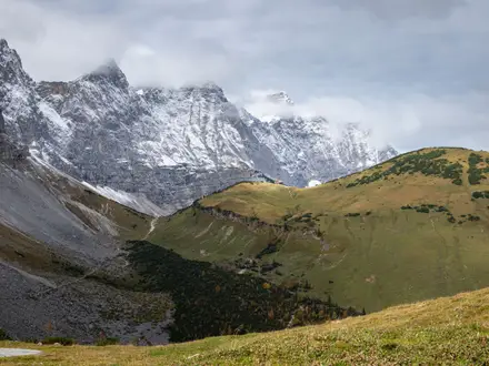
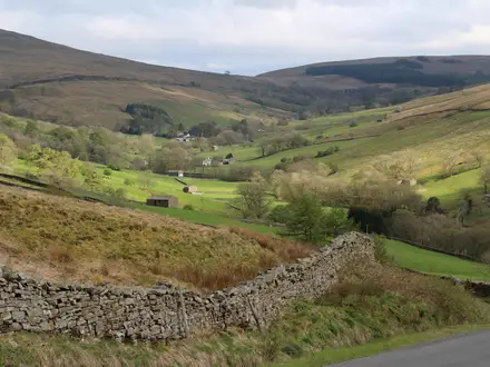
The route starts at Formarinsee, reached by hiking bus from Lech, then follows the Lech downstream through Vorarlberg, Tyrol and into the Allgau. The classic 7-day line links Lech, Warth/Lechleiten, Holzgau, Elbigenalp, Stanzach, Wangle and finally Fussen, finishing at the Lechfall. It is a point-to-point walk with a net downhill profile from about 1,793 m to roughly 800 m, though the total ascent still adds up over the week. Compared with high-level Austrian routes such as the Eagle Walk or Carnic High Trail, the Lechweg stays valley-based and non-technical.
How the Lechweg Became a Cross-Border Alpine Trail
The Lechweg opened in June 2012 as a joint project across Vorarlberg, Tyrol and the Allgau. It was designed as the first relaxed, valley-based long-distance walking route in this part of the Alps, avoiding the need for alpine experience. In 2012 it also became the first cross-border route certified as a Leading Quality Trail - Best of Europe by the European Ramblers' Association, based on criteria including waymarking, scenery and trail experience.
Notable highlights
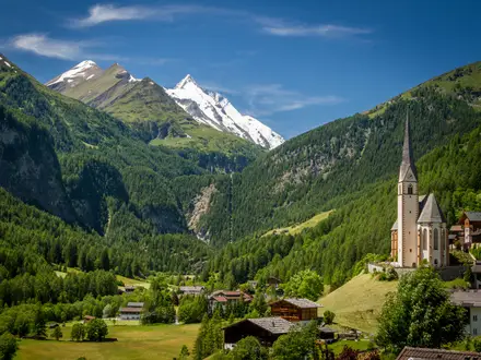
Formarinsee and the source of the Lech: The trail begins at this clear mountain lake at about 1,793 m beneath the Rote Wand, close to where the River Lech rises. It is the high point of the route before the long downstream journey.
Holzgau suspension bridge: A short loop from Holzgau reaches Austria's highest and longest free pedestrian suspension bridge, 200.5 m long and 110 m high, over the Hohenbach gorge near the Simms waterfall.
Doser Waterfall: Near Haselgehr, this waterfall is known for a local tradition that it dries up on St Martin's Day and flows again on St George's Day. The legend names a dragon; scientists suspect a snow-fed underground reservoir.
Lechtal/Reutte Nature Park: The Tyrolean Lech here is one of the last near-natural wild river landscapes in the Northern Alps, with braided gravel banks and floodplain habitats beside the walking route.
Lechfall and Fussen: The finish is the Lechfall, where the river drops through a rocky gorge at Fussen. The Bavarian royal castles of Neuschwanstein and Hohenschwangau are within sight of the area.
Challenges to expect
The Lechweg is not technically alpine, but the daily distances are real: the final classic stage to Fussen is 24.6 km. Expect mixed natural paths, gravel tracks, forest sections, occasional rocky ground and some tarmac through villages. Early summer snow can linger on the high opening section near Formarinsee, so June starts need checking. For a similarly approachable Austrian valley option, compare the Brandnertal Valley Trails; for a longer inn-to-inn journey, see the Alpe-Adria Trail.
HikeList Score
Lechweg scored 92/100 on HikeList's trail-quality metrics.
See score breakdownHide breakdown
- Ideal length 100
- Balanced challenge 100
- Scenery & wildness 98
- Varied terrain 71
- Accommodation 83
- Food & support 88
- Path quality 98
- Season flexibility 76
Computed from length, challenge, scenery & wildness, terrain variety, accommodation, food & support, path quality and season flexibility.
Show more data Show less
- Mountainous
- Forest
- Dirt
- Gravel
- Rocky
- Hotels
- Guesthouses
- Huts
- Family Friendly
- Pet Friendly
- Restrooms
- Water Sources
- Shelters
- Picnic Areas
Download Our Full Guide to Lechweg FREE!
Get our comprehensive guide to this hike for free. Save it for later reading or print out at home.
In these collections
Photos from hikers
Taken on the trail by people who've reviewed Lechweg.
Lechweg: The Complete Guide
The Lechweg is a practical, rewarding alpine river walk for hikers who want mountain scenery without technical mountain terrain. It runs point-to-point from Formarinsee near Lech am Arlberg in Austria to the Lechfall in Füssen, following the River Lech from a high lake near its source down through Vorarlberg, the Tyrolean Lechtal and into Bavaria.
Its strongest appeal is the river itself. The Tiroler Lech Nature Park protects one of the last near-natural wild river landscapes in the Northern Alps, so much of the route stays close to braided gravel banks, turquoise channels, alluvial forest and open riverside meadows rather than climbing away onto exposed ridges.
The walk also has an unusually satisfying shape: reach Formarinsee by hiking bus, then follow the Lech as it gathers size and force over a week before dropping through the Lechfall gorge at Füssen. Along the way, the 200.5 m Holzgau suspension bridge over the Höhenbach gorge gives the route one of its most memorable set pieces, while Füssen places Neuschwanstein and Hohenschwangau within easy reach after the finish.
Logistically, this is one of the more approachable long-distance alpine walks. Valley villages, guesthouses, partner accommodation, baggage transfer and the regional Regiobus make it suitable for inn-to-inn walkers, fit first-timers, families and many dog owners, with the option to walk sections from a fixed base rather than moving every night.
What the Lechweg asks for is steady walking fitness, not mountaineering skill. The terrain is moderate and waymarked, but the later classic stages are longer, including roughly 19.7 km to Stanzach, 20.9 km to Wängle and a final 24.6 km stage into Füssen, so pacing, footwear and accommodation planning matter.
This guide covers stages, itinerary choices, accommodation, food, transport, terrain, baggage options and common planning mistakes.
Stage-by-Stage Guide
The classic Lechweg is normally divided into seven walking days. Distances are manageable in the first half, but the final three stages are noticeably longer, so accommodation choice, food supplies and bus options matter more as the trail moves down the Lechtal.
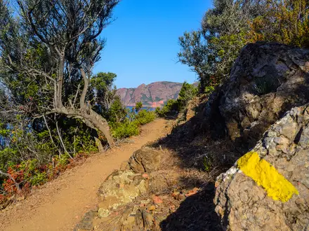
The route is consistently marked with the Lechweg waymark — a white “L” on a dark anthracite background — though on the high opening section near Formarinsee this is largely replaced by red-white-red alpine markings. An offline map or the Lechweg app is still useful for variants, accommodation access and bus stops. The Regiobus is especially useful for shortening stages or recovering from bad weather; timetable details should be checked before travelling.
Stage 1: Formarinsee to Lech am Arlberg — 14.4 km
This opening stage starts high, at Formarinsee, and is the most alpine-feeling day of the Lechweg without becoming technical. The trail begins near the source of the Lech, then follows the young river downstream through alpine pasture, pockets of forest and the Zugertal valley towards Lech am Arlberg.
The high point of the whole trail is reached near the Formarinalpe above the lake, at about 1,871 m. From there the day is predominantly downhill, with natural footpaths, gravel tracks, boardwalks along riverbanks and stone-paved sections as the route enters Lech.
Key landmarks include Formarinsee, the Capricorn Monument on the route of one of Europe’s largest ibex colonies, the village of Zug, the fish pond near Zug and Kneipp wading pools along the way. The mountain setting is at its best early in the day, so it is worth taking the first part slowly rather than treating it simply as a descent into Lech.
There are no services at Formarinsee itself, so arrive with food and water already packed. Gasthaus Älpele is a useful rest stop around 9 km into the stage, and Fischerwirt in Zug gives another option before Lech. Lech am Arlberg has supermarkets, bakeries, ATMs, restaurants and an outdoor retailer.
Lech has the widest accommodation choice on the first half of the route, from hostels such as Lech Hostel and Der Lecher to hotels including Hotel Tannbergerhof and Post Lech Arlberg. It is a premium ski-resort town, so some hotels close between seasons; check opening dates before booking.
Access to the start is by hiking bus line 707 from Lech am Arlberg centre to Formarinsee. The bus runs up to five times daily in season and is free with the relevant guest card. There is no road parking at the lake, so the bus is not just convenient but the normal way to begin the trail.
Navigation is straightforward from the start, following the Lechweg “L” markers and, on the highest ground, the red-white-red alpine markings. The main seasonal concern is snow lingering on the high opening section into June; early-summer walkers should check current conditions before committing to the Formarinsee start.
Stage 2: Lech am Arlberg to Warth / Lechleiten — about 14.2 km
Stage 2 leaves the resort setting of Lech and moves into a quieter, wilder valley landscape. It is a shorter day than those later in the week, but it includes a steady final climb and some narrower gorge-side walking that requires attention underfoot.
From Lech centre the trail climbs above the valley floor on paths and forest trails, then heads north-east above the Lech gorge. The first part is a mix of farmland, alpine meadows and woodland, with views back into the upper Lech valley.
After roughly two-thirds of the stage, the Lechschlucht becomes the dominant feature. The gorge is narrow and steep in places, though the path is well developed; sure-footedness is useful, especially in wet conditions. The route crosses on a wooden bridge, then climbs through high forest towards Warth at about 1,500 m.
Landmarks on this stage include the Lech Gorge views, the Grenztobel boundary between Lech and Warth, the Krumbach suspension bridge and Seebachsee before Warth. In Warth, Vorarlberg’s highest-altitude alpine dairy and butcher’s shop is a practical and worthwhile stop.
Food options are much fewer than in Lech. Stock up before leaving Lech, then use cafés or restaurants in Warth at the end of the stage. Warth is small, so do not assume late-evening food or shop options will be available without checking.
Accommodation in Warth is a mix of small hotels and Gasthöfe, including options such as Berghotel Biberkopf and Wäldermetzge Hüttenzimmer. There are fewer beds than in Lech, so book ahead, especially in the main summer walking season.
Public transport follows the wider Lechtal corridor, with the Lech am Arlberg–Reutte bus line 110, also written as 4268, serving the region. This can help with stage adjustments, but current stops and times should be checked before travelling.
This is a good acclimatisation day before the Lechweg becomes more settled into the Tyrolean Lechtal. The practical warning is not exposure, but narrow path sections near the gorge and the final ascent to Warth, which can feel more tiring than the distance suggests.
Stage 3: Warth to Holzgau — about 15.4 km
Stage 3 crosses from Vorarlberg into Tyrol and gives the first long sense of the Lechtal as a broad alpine river valley. It is a moderate day, with panoramic hillside walking early on and easier valley-floor walking after Steeg.
From Warth, the route passes through Lechleiten, a Walser hamlet strung along the hillside above the valley. The path then descends on well-developed panoramic tracks towards Steeg, with repeated views down to the turquoise Lech.
The Vorarlberg–Tyrol border is crossed on this stage. After Steeg, the walking becomes flatter and follows the valley through Hägerau towards Holzgau. The Hägerauer or Grießbach Waterfall can be seen from the bridge, and the Hägerau Kneipp foot-bath facility is another small trail-side stop.
Steeg is the main service point before Holzgau. Food options include the Postwirt restaurant and the Naturkäserei Sojer cheese shop, while a self-service station en route offers isotonic drinks and dairy products. Fill water in Steeg or Holzgau rather than relying on minor points between settlements.
Holzgau is one of the most attractive overnight stops on the route, known for its Lüftlmalerei: Baroque exterior frescoes painted on historic house façades. Accommodation includes Posthotel Lechtal Arlberg and smaller guesthouses such as Vera Monti, but beds are still limited enough to make advance booking sensible in peak season.
Public transport along the valley makes Steeg and Holzgau practical access or exit points. The Regiobus is useful if weather, fatigue or accommodation availability requires a shorter day.
The terrain is varied but not technical: panoramic hillside paths, some serpentine descents, then flat valley walking. The main planning point is to avoid rushing through Holzgau, as Stage 4 begins with one of the route’s most distinctive sections.
Stage 4: Holzgau to Elbigenalp — about 13.4 km
This is the signature stage of the Lechweg and the day with the most obvious route-choice decision. It is not the longest day, but it includes steeper mountain paths, boardwalks and the famous Holzgau suspension bridge option.
From Holzgau the trail climbs on more demanding mountain paths and partly on wooden walkways across the Schigge. Underfoot conditions are more varied than on the flatter valley stages, and sure-footedness is helpful, particularly if the boards or paths are wet.
The key decision comes at the Höhenbach gorge. The direct and dramatic option crosses the Holzgau suspension bridge, a free pedestrian bridge about 200.5 m long and 110 m high. It is about 1 m wide and is walked in single file, so anyone uncomfortable with heights should take the alternative without hesitation.
The alternative route goes through the Höhenbachtal to the Simms Waterfall and Café Uta. It is slightly longer and more sheltered, and it is a scenic route in its own right rather than a poor substitute for the bridge.
Both options continue towards Bach, then ease back to the valley floor for the walk to Elbigenalp. Bach has basic services and access to the Lechtaler Bergheumuseum nearby; the Jöchelspitze cable car is accessible from near Bach as a detour, but it is not on the main Lechweg.
Food and drink are available at Café Uta if taking the Höhenbachtal alternative, with further basic services in Bach. Elbigenalp has a supermarket, restaurants and cafés, including Gasthof Zur Geierwally, which also has a small display linked to Anna Stainer-Knittel, the Geierwally figure associated with the village.
Elbigenalp is a strong overnight base with one of the better service selections between Lech and Reutte. Accommodation options include Hotel Stern, Hotel Post, Haus Walch and Hotel Panorama.
Transport access is possible in Bach and Elbigenalp via the valley bus network. The stage is short enough for most walkers, but the bridge choice, wet boards and steeper initial paths make it a day to start steadily rather than late.
Stage 5: Elbigenalp to Stanzach — about 19.7 km
Stage 5 is one of the tougher days in the classic seven-day itinerary. It is nearly 20 km, includes more ascent and descent than the valley-floor profile might suggest, and has a sustained middle section above the Lech.
From Elbigenalp the trail follows the Lech towards Häselgehr, then climbs after the church towards Luxnach and the Doser Wasserfall. The route continues on the Burweg and Panoramaweg above the valley to Elmen, before dropping back towards Vorderhornbach and continuing to Stanzach.
Häselgehr is notable for the parish church of St. Martin, with Nazarene-style interior decoration and walls partly covered in etched brass. The village also has a natural sulphurous outdoor swimming pool.
The Doser Wasserfall is one of the stage highlights, emerging from a rock grotto near Luxnach. It is linked to the local legend that it dries up on St Martin’s Day and begins flowing again on St George’s Day; in practical terms, it normally flows from 23 April to 11 November.
Further along, the Burweg and Panoramaweg give elevated valley views before the descent towards Elmen. The Lechzopf viewpoint near Elmen and Vorderhornbach, sometimes nicknamed the Meran of the Lechtal for its mild microclimate, are the main landmarks before Stanzach.
Food and water planning matters on this stage. Häselgehr has a restaurant and basic services, and Vorderhornbach has a restaurant, but the day is long enough that snacks and at least 1.5 litres of water should be carried from the start. Stanzach has the last supermarket before Weißenbach on the next stage, so buy supplies on arrival if needed.
Accommodation in Stanzach includes Hotel Garni Waldhof, Natur- & Wanderhotel Föhrenhof and Camping+Rooms Lechtal. Stanzach is a practical overnight stop because it sits directly on the line of the next long valley stage.
The terrain is mixed: flat riverside walking at first, an uphill section to Luxnach and the Panoramaweg, then descent and flatter paths to Stanzach. The elevated sections are not exposed alpine ground, but they do require sure-footed walking, particularly after rain.
Walkers who want a gentler itinerary should consider splitting this section by staying around Häselgehr or Elmen as part of an eight-day plan. The Regiobus can also be used to shorten the day if conditions or fatigue make the full stage unattractive.
Stage 6: Stanzach to Wängle — about 20.9 km
Stage 6 is long but generally easier underfoot than Stage 5. This is the day when the wide, gravelly, braided character of the Tiroler Lech is most apparent, with long sections on riverbanks, field paths and forest tracks.
From Stanzach the route follows the Lech’s broad gravel banks towards Forchach, where a suspension bridge is a minor highlight. The trail then continues to Weißenbach am Lech, an important resupply point with a supermarket.
After Weißenbach the route passes Rieden, where two variants become relevant. The more panoramic and cultural option goes via the Ehrenberg Ruin, Highline179 and Schlosskopf fortress above Reutte, adding extra ascent. The flatter river variant stays closer to the Lech via the Hornberg debris barrier to Ehenbichl.
Highline179 is a famous nearby pedestrian suspension bridge, 406 m long, linking the Ehrenberg ruins and Fort Claudia above the B179 road. It is separate from the Lechweg and requires its own ticket, while the ruins can be viewed without treating the bridge as compulsory.
Food stops are better than on some earlier stages but still need planning. Stanzach is useful in the morning, Weißenbach is the critical supermarket stop, Gasthof Kreuz in Rieden has a beer garden, and Reutte offers full town services including supermarkets, cafés, an ATM and a pharmacy. Café Knittel in Reutte is a useful stop for hot drinks and cake.
Wängle and nearby Reutte have a good accommodation range. Options include Hahnenkamm Hostel, Hotel Krone Tirol and Wellness Aparthotel Lechlife, with wider choice in Reutte about 10 minutes away by bus. Weißenbach and Rieden are also practical places to split the stage.
The terrain is predominantly flat or gently undulating unless taking the Ehrenberg variant, which adds about 200 m of ascent. Expect gravel riverbanks, field tracks and some forest rather than mountain paths.
Bus line 110 / 4268 between Lech and Reutte is useful through this part of the valley, and Reutte has good onward bus connections. This makes Stage 6 one of the easiest days to shorten or adjust if the weather turns poor.
The main warning is distance. The walking is not technically difficult, but 20.9 km after several previous days on foot still deserves an early start and a proper food plan, especially because the following day is longer again.
Stage 7: Wängle to Füssen — about 24.6 km
The final stage is the longest day of the classic Lechweg and should be treated as a full walking day. It combines a panoramic high path above the Reutte basin, forest paths, the Austrian–German border crossing, lakeside walking near the Alpsee and an urban finish at the Lechfall in Füssen.
From Wängle the route climbs to the high panoramic path and passes the Costarieskapelle chapel, which gives broad views over the Reutte basin. The trail then continues towards Frauensee and Hinterbichl before descending to Pflach.
Pflach is a useful landmark for the bird observation tower on the Vogel-Erlebnispfad and the nearby Pindarplatz viewpoint. After Pflach the route crosses into Germany on forest tracks; there is no formal border checkpoint.
The Bavarian approach to Füssen is one of the scenic rewards of the final day. The trail reaches the Alpsee, with views towards Hohenschwangau and Neuschwanstein, then follows the Alpenrosenweg past the Sternschanze fortification and Kalvarienberg before finishing at the Lechfall.
The Lechfall is the formal end of the trail: a gorge and waterfall where the Lech drops over a natural rock step at the edge of Füssen. The viewing area is fenced and lit, with a short walkway giving access to the finish viewpoint.
Food and water are limited between Wängle and Pflach, so leave Wängle with enough water and snacks for the long opening section. Füssen has full town services, including restaurants, supermarkets, cafés, bakeries and hotels around the old town and Lechfall area.
Füssen accommodation ranges from budget options such as Bavaria City Hostel to hotels including Hotel Hirsch, Hotel Sonne and Parkhotel Bad Faulenbach. Book well ahead for July, August and weekends, as Füssen is very busy because of Neuschwanstein and Hohenschwangau.
Füssen Bahnhof is on the Munich–Füssen rail line, with direct trains taking roughly two hours to Munich Hauptbahnhof and generally running around hourly. Bus line 100 links Füssen and Reutte, with onward connections towards Lech on line 110; current timetables should be checked before travelling.
Navigation remains straightforward on the Lechweg “L” waymarks, but fatigue is the main issue. Start by 7–8 am at the latest on the classic itinerary, especially if staying outside Füssen or planning onward travel the same evening.
The Royal Castles of Neuschwanstein and Hohenschwangau are about 3–4 km from the Lechfall. Visiting them properly is best handled by adding a second night in Füssen rather than trying to fit them into the end of the longest walking day.
Recommended Itinerary
Standard 7-day itinerary
This is the classic end-to-end schedule from Formarinsee to the Lechfall. It suits fit walkers who are comfortable with repeated 15–25 km days and one notably long final stage into Füssen.
| Day | From | To | Approx. distance | Why this stage makes sense | Services/accommodation notes |
|---|---|---|---|---|---|
| 1 | Formarinsee | Lech am Arlberg | 14.4 km | A logical high-level start at the source area of the Lech. The day begins at the lake, reaches the trail high point near Formarinalpe, then descends to Lech am Arlberg, so it is moderate but can be hard on legs at the start of a trip. | Reach Formarinsee by hiking bus from Lech am Arlberg in season. Lech am Arlberg is a full-service resort village with hotels, restaurants and shops. Early-season snow on this opening section should be checked before travelling. |
| 2 | Lech am Arlberg | Warth / Lechleiten | 14.2 km | A manageable second day through alpine meadows and Walser settlements, moving from the Arlberg area towards the upper Lechtal. Ending at Warth or Lechleiten keeps the first two days sensible before the route settles into lower valley walking. | Warth and Lechleiten are smaller than Lech am Arlberg, so accommodation should be booked ahead. Services are more limited, but this is a practical overnight before continuing towards Steeg and Holzgau. |
| 3 | Warth | Holzgau | 15.4 km | This stage gives a good transition into the Lech valley proper, passing via Steeg and continuing towards one of the trail’s best overnight villages. It is long enough to make progress without forcing an early big day. | Steeg is a useful stop en route. Holzgau is well set up for hikers, with accommodation and dining options, and is the key base for the Höhenbach/Hohenbach suspension bridge and the village’s painted façades. |
| 4 | Holzgau | Elbigenalp | 13.4 km | The shortest classic stage is well placed after the first three days. It allows time either for a slower morning in Holzgau or an afternoon in Elbigenalp, rather than turning the middle of the walk into a forced march. | The route passes through Bach before reaching Elbigenalp. Elbigenalp has several services for a valley village, including restaurants, food shops and partner accommodation. |
| 5 | Elbigenalp | Stanzach | 19.7 km | One of the two longer classic stages, but it follows a natural progression down the Lechtal via Häselgehr, Elmen and Vorderhornbach. It is a good day for experiencing the Tiroler Lech landscape, with the Doser Waterfall near Häselgehr as a worthwhile feature. | Plan food and rest stops rather than treating this as a short valley stroll. Stanzach is an important resupply stop, with a grocery supermarket; the next supermarket is in Weißenbach. Accommodation is available in the village. |
| 6 | Stanzach | Wängle | 20.9 km | Another long day, but generally less severe underfoot than the distance suggests, with much of the walking through the river valley and the Tiroler Lech Nature Park. The stage carries you past Forchach and Weißenbach towards the Reutte area, leaving a clear final approach to Füssen. | Weißenbach is the main mid-stage service point and has a supermarket. Wängle is a practical overnight before the final day; Reutte is nearby and has fuller services including supermarkets, pharmacies and restaurants. |
| 7 | Wängle | Füssen | 24.6 km | The longest and most demanding classic day, with the Höhenpanoramaweg, the Austrian-German border crossing, Pflach, Alpsee and the final approach to the Lechfall. Keeping this as the final stage works well because Füssen has extensive accommodation and onward transport. | Start early and carry enough food and water for a long day. If the full stage is too much, the Regiobus can be used to shorten the day by travelling to Pflach and walking the final section to Füssen. Füssen has hotels, restaurants and a railway station. |
Slower variants
An 8-day itinerary is the better choice for many walkers. It keeps the character of the classic route but softens at least one of the longer days, usually around the Stanzach section or the final approach to Füssen. Exact breakpoints vary by accommodation availability, so the stage plan should be checked against the official mapping before booking.
A 10-day itinerary is the most relaxed way to walk the full Lechweg. Daily stages are typically shorter, with more time for Holzgau, the suspension bridge, Elbigenalp, the Tiroler Lech Nature Park and Füssen. This pace suits first-time multi-day walkers, families, older walkers, dog owners and anyone carrying a heavier pack.
The free regional Regiobus available with the relevant guest card also makes a base-based approach possible in the Lechtal. Instead of changing accommodation every night, you can stay in one valley village and use the bus to reach and leave daily trail sections. This is especially useful for families or walkers who want to avoid daily packing.
Faster variant
A faster schedule is only sensible for strong walkers who are already comfortable with long back-to-back days. Compressing the full route means combining sections from the standard itinerary and accepting days at or above the length of the Wängle–Füssen finish; exact distances and overnight points should be checked on official mapping before booking.
Some 6-day package versions start at Steeg, which skips the high opening stages from Formarinsee and Lech am Arlberg. That can be a practical shorter holiday, but it is not the full source-to-Lechfall route.
Planning the Route
The Lechweg is straightforward to follow, but it rewards careful logistics. The main planning job is not route-finding; it is securing accommodation in the right villages, matching the longer stages to fitness, and making sure the seasonal buses are running when you need them.
Most walkers should allow 7 or 8 walking days. The classic 7-stage itinerary is realistic for fit walkers, but the final two days are longer, with the last stage to Füssen reaching about 24.6 km. An 8-day plan gives more margin for café stops, bad weather, tired legs and the suspension bridge loop near Holzgau.
Choosing a 7, 8 or 10-day itinerary
| Itinerary | Best for | Planning notes |
|---|---|---|
| 7 days | Fit walkers who are happy with full walking days | The standard version. Expect daily stages from about 13.4 km to 24.6 km, with the longest day at the end. |
| 8 days | Most first-time visitors and relaxed inn-to-inn walkers | Shorter daily distances and a better buffer if accommodation is tight. Commonly splits the route around Steeg/Bach. |
| 10 days | Walkers wanting a slow, decelerated trip | Gives time for side loops, village stops and nature-park activities. Offered by several tour operators. |
| 6 walking days from Steeg | Walkers short on time | Skips the first two stages from Formarinsee and Lech am Arlberg. This is a reduced version, not the full Lechweg. |
The route is net downhill from the high opening stage near Formarinalpe to the Lechfall in Füssen, but it is not a flat riverside stroll throughout. There are forest paths, occasional rocky sections, gorge passages and repeated small climbs away from the river. Published ascent totals differ; HikeList uses about 2,260 m as the working figure, while some official stage data gives a higher total, so daily stage profiles are more useful than the headline number.
Let accommodation shape the stages
The Lechweg is village-based. Overnight stops are normally planned around Lech am Arlberg, Warth, Steeg, Holzgau, Bach, Elbigenalp, Häselgehr, Elmen, Stanzach, Weißenbach, Wängle, Pflach and Füssen.
Accommodation is strongest in Lech am Arlberg, Warth, Holzgau, Elbigenalp, Stanzach and Füssen. Smaller places such as Steeg, Bach, Häselgehr, Elmen, Vorderhornbach, Forchach, Weißenbach, Wängle and Pflach have fewer beds, so it is sensible to book these first and build the walking plan around what is available.
July and August are peak season across the valley. For a summer trip, accommodation should ideally be booked 2–3 months ahead, especially if walking without a package and aiming for specific villages. The official Lechweg partner accommodation list is the most useful starting point because it focuses on lodgings set up for walkers.
Self-guided packages from operators such as Eurohike, Alpenlandtouristik, Beringtravel, Wild Rover Travel, Eurotrek and Natural Adventure can remove much of this work. These packages typically arrange accommodation and luggage transfer, which is helpful if booking late or walking during peak holiday weeks.
Shortening stages and section hiking
The Lechweg is unusually easy to shorten for an alpine long-distance trail. The Regiobus network follows the valley corridor, so tired walkers can trim a day, bypass a section, or return to a previous overnight base without complicated transfers.
Lines 110 between Lech am Arlberg and Reutte and 100 between Reutte and Füssen link the route corridor. This makes section hiking practical, including walking individual stages from a fixed base. A full return between Füssen and Lech via Reutte takes around 3 hours and costs roughly €20 per person, but current fares and timetables should be checked before travelling.
A useful option is the “star walk” approach: stay several nights in one Lechtal village and use the Regiobus to reach each day’s start and return from the finish. This reduces packing and unpacking, and works particularly well for walkers who want flexibility in poor weather.
The Lechtal Aktiv Card, provided free with many participating accommodation stays, covers free Regiobus use on the Lech–Füssen corridor from the second day of the stay. It also gives discounts on some local facilities. Check that the chosen accommodation participates before relying on it.
Getting to the start at Formarinsee
The first stage starts at Formarinsee, above Lech am Arlberg, and normally requires the seasonal hiking bus from Lech Rüfiplatz. Line 707 runs to the Formarinsee area from mid-June to early October, but only with a handful of departures each day rather than a frequent service.
There are usually only a few departures between mid-morning and mid-afternoon, and the timetable changes seasonally, so plan the first day around a specific bus rather than assuming one will be along shortly. Check the current Line 707 timetable before booking the first night or fixing a start time; VVT timetable information is the key reference.
The bus fare to Formarinsee is around €25–26 including the toll, with different rules for children and Lech Card holders. Current prices should be confirmed before travelling.
Extending the walk
The simplest extensions are the nine signed Lechschleifen loops along the route. These are side walks rather than compulsory Lechweg stages, and are best added by building in an extra night or choosing the 8- or 10-day itinerary.
The Tiroler Lech Nature Park also offers guided activities from the Naturparkhaus in Elmen. These are useful if the trip is planned as a slower valley-based holiday rather than a point-to-point through-walk.
At Lech am Arlberg, the route can also be combined with other Tyrolean long-distance walking options, including the Eagle Walk (Adlerweg). This needs separate planning, as the Lechweg itself is a valley trail rather than a high alpine traverse.
Food and water planning
Food logistics are simple compared with remote mountain routes. Good resupply and meal options are found in Lech am Arlberg, Warth, Holzgau, Elbigenalp, Stanzach, the Reutte area and Füssen, and most stages pass through or near villages with Gasthöfe or inns.
Do not assume every small-village inn will serve food at the exact time you arrive. Weekday lunch hours, rest days and seasonal closures can affect smaller places, so check evening meals and packed lunches when booking accommodation.
The first stage from Formarinsee to Lech am Arlberg has minimal services once underway. Start with enough water and food for that stage, especially in warm weather. On later stages, carrying a normal day supply is usually enough; there is no need to carry several days of food.
Luggage transfer
Luggage transfer is well established on the Lechweg and is useful if walking inn-to-inn with only a daypack. The official Gepäcktransport service is operated by Feuerstein GmbH in Steeg.
The standard price is around €13 per bag per stage when booked at least two days ahead, with a higher last-minute price of around €15. Bags are limited to 20 kg and specified dimensions, and are normally delivered to the next accommodation by 18:00. Current prices and seasonal terms should be checked before booking, particularly before early June or after mid-September.
Many accommodations can help arrange the transfer directly. This is worth doing as soon as the overnight stops are fixed, rather than leaving it until arrival.
Navigation and maps
Navigation is a low-risk part of the planning. The route is well waymarked with the Lechweg “L” signs — a white “L” on a dark anthracite background — and is suitable for walkers with limited navigation experience, provided normal mountain-walking judgement is used.
Offline mapping is still recommended. Mobile signal can be variable in gorge sections, and a downloaded GPX track is useful if signs are missed near villages or forest junctions. Komoot, Outdooractive and Wikiloc all carry Lechweg route data, and the komoot collection maps an 8-stage version of about 127 km.
Season and weather planning
The practical season is mid-June to early October. The opening section near Formarinsee and Formarinalpe reaches the route’s highest ground and can retain snow into June, so early-summer starts should be checked carefully.
July and August have the broadest service availability but also the highest accommodation pressure. September is often a better planning month for walkers who want quieter villages, cooler walking conditions and easier booking.
From mid-October onwards, many guesthouses reduce opening or close, and seasonal transport such as Line 707 is reduced and then withdrawn. A late-season trip should not be planned without checking both accommodation and bus operation.
Nature-park rules and dogs
Much of the Tyrolean section passes through the Tiroler Lech Nature Park, one of the key reasons the route is special. Stay on marked paths and respect restricted gravel-bank areas, which are closed to visitors from 1 April to 31 July during the bird breeding season.
Wild camping is prohibited within the nature park, and campfires, drones and removal of plants or natural materials are not allowed. Formal campsites exist only at Reutte, Vorderhornbach and Häselgehr, so the Lechweg is best planned as an inn-to-inn walk unless using those specific campsites.
Dogs must be kept on a lead in the protected area. On public buses, dogs also require a muzzle, so this needs to be packed and used if relying on Regiobus links.
Towns, Villages and Overnight Stops
The Lechweg is unusually straightforward for an alpine long-distance trail: most overnight stops are valley villages with guesthouses, hotels or pensions, and the Regiobus makes it possible to shorten stages or base yourself in one place. Services are not evenly spread, though. Lech am Arlberg, Holzgau, Elbigenalp, Stanzach, Reutte and Füssen are the most useful places for food, cash, transport or problem-solving.
Smaller hamlets can be excellent quiet overnights, but do not assume they have a shop or an evening meal available. In June and October especially, accommodation and restaurant opening dates should be checked before travelling.
Formarinsee
Formarinsee is the mountain-lake start of the Lechweg, close to the source of the River Lech. It is not a village and has no normal hiker infrastructure: no shops, no accommodation at the lake itself and no place to rely on for supplies.
Most walkers reach the start by the seasonal hiking bus from Lech am Arlberg, then walk back down to Lech on the first stage. Line 707, the Lech local bus, runs to Formarinsee in the hiking season, generally from mid-June to early October, with a journey of about 30 minutes. Exact operating dates and ticket rules should be checked before travelling.
Arrive with water, food for the first day and enough warm clothing for a high start. Even though the route trends downhill overall, this is still the highest and most weather-exposed part of the trail.
Lech am Arlberg
Lech am Arlberg is the first major overnight stop and the main practical base for reaching Formarinsee. It has the strongest services at the start of the trail, with hotels, guesthouses, pensions, restaurants, cafés, bakeries, ATMs, a post office, grocery stores and sports shops.
Accommodation is plentiful but can be expensive. Lech is a premium alpine resort, so summer rooms should be booked well ahead, especially if the first night needs to line up with the Formarinsee bus.
For transport, Lech is important. Line 707 runs up to Formarinsee, Line 852 connects Warth, Lech and Schoppernau, and there are connections towards Langen am Arlberg, which has mainline trains towards Innsbruck and Zürich. Walkers staying at least one night in Lech may receive guest-card benefits including hiking-bus use; current conditions should be checked when booking.
Use Lech to sort any last equipment issues before starting. It is one of the few places on the route with a broad choice of shops and outdoor services.
Warth
Warth is the usual second-night stop on the classic itinerary. It is a small high mountain village, but it has enough accommodation for walkers, including hotels, guesthouses and smaller B&B-style places.
Food options are more limited than in Lech, so do not leave resupply too late. There are hotels and restaurants, but walkers wanting specific trail snacks or picnic food should check provisions before leaving Lech.
Warth is served by Line 852 between Warth, Lech am Arlberg and Schoppernau. The Warth Card can include free hiking-bus use to Lech and Elbigenalp, making Warth a practical overnight even if a stage needs adjusting.
It is a good stop for hikers who want to keep the first two days moderate before descending fully into the Tyrolean Lechtal. The village also gives access to the high section between Lech, Warth and Lechleiten without needing to rush onward.
Lechleiten
Lechleiten is a tiny hamlet between Warth and Steeg, sitting high above the valley. It is passed on the Warth-to-Lechtal section and works best as a very quiet overnight or rest stop rather than a full-service village.
Facilities are minimal. Berggasthaus Alpenrose is a family-run guesthouse directly on the route, but there are no village shops, so any overnight here should be planned with dinner and breakfast arrangements agreed in advance.
Transport is limited compared with Warth or Steeg. Treat Lechleiten as a peaceful lodging option, not as a place to solve resupply or onward-travel problems.
Steeg
Steeg marks the entry into the Tyrolean Lechtal proper and is a useful alternative overnight between Warth and Holzgau. It has better services than many of the smaller valley villages, including accommodation, a grocery store, restaurants or Gasthöfe, an ATM and a noted cheese shop.
This is a sensible place to break the route if the high section from Warth feels long, or if accommodation in Holzgau is full. Guesthouses, holiday apartments and Gasthöfe are available, including options in and around Hägerau-Steeg.
Steeg is on the valley Regiobus network, with guest-card travel available for overnight guests. That makes it a practical point for shortening a day, rejoining the route or moving to another booked village if necessary.
Holzgau
Holzgau is one of the best overnight and resupply stops in the middle of the Lechweg. It is the classic end point after the Warth section and has a good spread of accommodation, restaurants, cafés, shops and walker-friendly services.
For practical planning, Holzgau is a strong place to restock. It has grocery stores, sports shops, a doctor, tourist office and several places to eat, so it is much more useful than the smaller settlements immediately before and after it.
The main local reason to pause here is the Holzgau suspension bridge, reached on a short signed loop near the Simms waterfall. It is about 200.5 m long and 110 m high, and is one of the best-known side features of the route.
Holzgau is served by the Regiobus valley service, normally free with the active guest card. If a multi-day itinerary needs a buffer night, Holzgau is one of the easiest central places to add one.
Bach
Bach is a small village between Holzgau and Elbigenalp. It sits on a relatively short Lechweg stage, so many walkers pass through rather than sleep here.
Accommodation is mainly in guesthouses and smaller local places. Food and shop options are limited, so check opening times before relying on Bach for lunch, dinner or supplies.
Bach has a stop on the valley Regiobus route. It can work as a quiet overnight, but Holzgau and Elbigenalp are much stronger service points on either side.
Elbigenalp
Elbigenalp is the largest and most useful settlement in the central Tyrolean Lechtal. It is the classic overnight after Holzgau and one of the best places on the whole trail for resupply, cash and practical errands.
Facilities include supermarkets, banks, a doctor, restaurants, hotels and guesthouses. There is an MPreis supermarket, and accommodation ranges from guesthouses to hotels within or close to the village centre.
Elbigenalp is also known for woodcarving, with Austria’s only woodcarving school and several carving workshops. For hikers, the main value is that it has real village services before the longer stage towards Stanzach.
The Regiobus serves Elbigenalp, with free travel for holders of the Lechtal Active Card. If baggage transfer, accommodation or stage timing needs adjusting, Elbigenalp is a good place to sort it out.
Häselgehr
Häselgehr is a small village on the Elbigenalp-to-Stanzach stage. Services are limited, and it is not a major resupply stop.
The local highlight is the Doser Waterfall, associated with the legend that it dries up on St Martin’s Day and flows again on St George’s Day. This makes Häselgehr worth a pause, but not a place to depend on for shops.
Camping Rudi lies just past the village and is one of the few camping options directly relevant to the route. The Regiobus stop is around 15 minutes from the village centre, so bus use is possible but not as immediate as in some other settlements.
Elmen
Elmen is another small Lechtal village between Häselgehr and Vorderhornbach. It has some guesthouse accommodation but only limited walker services.
Do not rely on Elmen for resupply unless current opening times have been checked. Carry food from Elbigenalp or plan to continue to a larger stop.
The village is on the valley bus route, which makes it useful for stage adjustment. As an overnight, it suits walkers looking for a quiet stop rather than full facilities.
Vorderhornbach
Vorderhornbach sits slightly away from the main valley line on the stage towards Stanzach. It is a small side-valley village with limited facilities but a useful camping option.
Camping Vorderhornbach is noted for good facilities, with a restaurant and bus stop around 10 minutes’ walk away. Shops should not be assumed, so campers and walkers should carry food or confirm meal options ahead.
This is a practical stop for hikers using campsites or wanting to split the longer central valley section differently. For standard inn-to-inn itineraries, Stanzach is usually the more convenient overnight.
Stanzach
Stanzach is the classic overnight after the long central stage from Elbigenalp. It is a quiet valley village but a useful one, with multiple guesthouses and a role as one of the main resupply points on the route.
It is worth arriving with accommodation booked, as the village is smaller than Holzgau or Elbigenalp. Evening meal arrangements should be checked with the accommodation if arriving late.
The next section towards Forchach crosses the Lechzopf braided-river landscape, one of the wildest-feeling parts of the valley floor. Stanzach is therefore a good place to start the following day with food and water already sorted.
Regiobus services link Stanzach with the rest of the Lechtal. This makes it a useful recovery point if a previous stage has run long or the weather has forced a change of plan.
Forchach
Forchach is a very small settlement between Stanzach and Weißenbach. It has minimal services and is best treated as a waypoint rather than a standard overnight stop.
There is a refreshment facility signed off the path before Forchach; follow local signs rather than assuming it is directly on the trail. Opening times can vary, so carry enough food from Stanzach.
The suspension bridge over the Lech here gives a good viewpoint over the river landscape. Forchach also has a bus stop, which can be useful if the stage needs shortening.
Weißenbach
Weißenbach is a small village in the Reutte district, reached after the quieter river sections beyond Stanzach and Forchach. It has limited services but is useful because of its position near the wider Reutte transport area.
The Kneipp foot-bath facility by the river is a simple but welcome stop for tired legs. For shopping, cash or rail access, Reutte is the more practical detour.
Weißenbach has bus connections, and Reutte is a short bus ride away. If accommodation is unavailable in Wängle or nearby villages, the Reutte basin gives more flexibility.
Wängle
Wängle is the classic overnight before the final day to Füssen. It lies near Höfen and the Reutte basin, with some accommodation and bus connections into Reutte.
Services in Wängle itself are more limited than in Reutte or Füssen, so meal and breakfast arrangements should be checked when booking. Reutte is around 3–4 km away on foot and is the better place for supermarkets, pharmacies, ATMs and transport connections.
This is a practical staging point because it sets up the final, longer walk to the Lechfall. If the last day looks too long, bus links in the Reutte basin can help adjust the plan.
Pflach
Pflach is the last Austrian village area before the route crosses into Bavaria. It is close to the Reutte basin and has only minimal services for walkers.
The nearby Lechauen meadows and bird-watching tower are the main local point of interest. For food, accommodation choice and transport, plan around Wängle, Reutte or Füssen rather than Pflach itself.
Pflach has a bus stop and is useful as a bail-out or adjustment point on the approach to the border. It is not normally a primary overnight stop on the classic itinerary.
Reutte, off-trail service hub
Reutte is not on the direct Lechweg line, but it is the key service hub for the lower Tyrolean section. It is the place to use for a railway station, larger supermarkets, cafés, shops, ATMs, pharmacies, hospital services and onward buses.
The town-centre station is on the Außerfernbahn line towards Garmisch-Partenkirchen and the regional rail network. Bus 110 links Reutte with Lech am Arlberg, and Bus 100 links Reutte with Füssen.
For Lechweg walkers, Reutte is most useful around Weißenbach, Wängle and Pflach. A detour of roughly 30 minutes from the trail area can solve most resupply or transport problems that the smaller villages cannot.
Füssen
Füssen is the finish town for the Lechweg, with the route ending at the Lechfall on the edge of town. It is the best place to spend a night after completing the trail, especially if travelling onward by train the next day.
Services are extensive: hotels, guesthouses, restaurants, cafés, supermarkets, ATMs and a post office. Food options are much broader than in the valley villages, including traditional Bavarian dishes such as Wiener Schnitzel, Spätzle and Sauerkraut.
Füssen railway station has direct trains to Munich, taking roughly two hours, operated by Bayerische Regiobahn (BRB). Bus 100 connects Füssen with Reutte, and onward bus links make it possible to return towards the Austrian side of the route.
The Füssen Card, available with overnight accommodation, can include free public transport to local hiking starting points. Neuschwanstein and Hohenschwangau castles are about 4 km from town, with shuttle buses from Füssen, making an extra night worthwhile if travel plans allow.
Campers can use Camping Brunnen, accessible by bus 78. Current bus times, guest-card validity and rail schedules should be checked before travelling.
Getting to the Start
The practical start for the Lechweg is Lech am Arlberg, not the Formarinsee itself. The trail begins at the Formarinsee, but walkers normally reach the lake by the dedicated Wanderbus line 707 from Lech, then walk the first stage back down to Lech am Arlberg.
Most walkers should aim to arrive in Lech the evening before Day 1. This avoids relying on same-day train, bus and mountain-bus connections before a 14.4 km opening stage.
By train
The nearest useful railway stations are Langen am Arlberg and St. Anton am Arlberg, both on the ÖBB rail network. From either station, continue by regional bus or taxi to Lech am Arlberg.
| Station | Usefulness for Lechweg | Onward connection to Lech am Arlberg |
|---|---|---|
| Langen am Arlberg | Closest station, about 15 km from Lech | Bus line 91 via Stuben and Zürs; about 20 minutes |
| St. Anton am Arlberg | Good alternative on the Arlberg railway | Bus line 92 via St. Christoph and Zürs; about 30 minutes |
From Innsbruck, trains to Langen am Arlberg or St. Anton am Arlberg take roughly 1 hour 20 minutes, followed by the bus to Lech. From Zürich, rail connections run via Feldkirch and Bludenz towards Langen or St. Anton, with a typical total journey of about 2–3 hours.
From Munich, the journey is more variable: expect roughly 2.5–4.5 hours by train to St. Anton or Langen, usually with changes via Innsbruck or Bregenz depending on the routing. Timetables and connections should be checked before booking, especially if trying to reach Lech in time for an afternoon arrival.
Once in Lech am Arlberg, the line 707 hiking bus is needed for the final climb to the Formarinsee start. This should be checked before travelling, as the bus operates seasonally and the timetable changes by date and day of week.
By bus
The key bus for the start is Wanderbus line 707, which runs from Lech am Arlberg Dorfhus to the Formarinsee lake stop. The journey takes about 30 minutes.
In the 2025 season the Formarinsee bus was scheduled from 12 June to 5 October. It runs only a few times a day — roughly every couple of hours across the middle of the day rather than hourly — so use the current timetable on vmobil.at or the Lechweg bus-connections page before fixing travel plans.
The Formarinsee access road is a toll road, and the bus fare includes the toll. The fare has been around €26 per person for a one-day ticket, with children under 14 free in a family group; tickets are available at the Lech tourism office at Dorfhus or on board. Current prices should be checked before travelling.
Regional buses also help with longer trail logistics. Line 110 links Reutte and Lech am Arlberg, while line 100 links Füssen and Reutte. This makes it possible to travel from the finish at Füssen back towards the start, or to leave a vehicle at the finish and bus to Lech; the Füssen–Reutte–Lech journey takes about 3 hours with changes and has been around €20.
Dogs must travel on public transport with a muzzle and lead. This applies to buses and trains and should be planned in advance if walking the Lechweg with a dog.
By car
Drivers normally aim for Lech am Arlberg, then take the line 707 bus to the Formarinsee start rather than driving to the lake. The access road above Lech is controlled by toll and seasonal arrangements, so the bus is the simpler option for most walkers.
From Innsbruck, the usual approach is west on the A12/E60, leaving towards Imst/Landeck, then continuing via the B197 Arlbergpass road or the Arlberg Tunnel towards Stuben/Langen and on to Lech via the L198 Flexenpass/Lechtalstraße. The Arlberg Tunnel is tolled.
The Flexenpass road is a summer access route, and an alternative approach via Warth may also be possible in summer. Alpine road conditions and closures should be checked before travelling.
Parking in Lech village is limited and charged. Underground car parks include the Mühle garage and Anger underground car park, with the Mühle garage costing around €26 per day; long-stay arrangements should be verified locally before leaving a vehicle for a week.
For a point-to-point walk, it can be more practical to leave the car at Füssen, the finish, and take regional buses back to Lech before starting. This avoids paying for a full week of parking in Lech and removes the need to return there after reaching the Lechfall.
From the nearest airport
Innsbruck Airport is the most practical airport for starting the Lechweg. From the airport, travel to Innsbruck Hbf, take an ÖBB train to Langen am Arlberg, then bus line 91 to Lech am Arlberg; the whole journey is roughly 2 hours if connections line up.
| Airport | Practicality | Typical onward route |
|---|---|---|
| Innsbruck Airport (INN) | Best option for Lech am Arlberg | Airport to Innsbruck Hbf, train to Langen am Arlberg, bus 91 to Lech |
| Zürich Airport (ZRH) | Good rail option | Train via Feldkirch and Bludenz to Langen/St. Anton, then bus to Lech |
| Munich Airport (MUC) | Useful for finish logistics, slower for the start | S-Bahn to Munich Hbf, then rail west with changes; Füssen is about 2 hours from Munich by train |
| Friedrichshafen Airport (FDH) | Road transfer often simpler | Limited rail convenience; private transfer or car hire may be more practical |
Private taxis and alpine transfer services run from Innsbruck and other airports to Lech am Arlberg. These should be booked in advance, particularly for evening arrivals or early-season dates when public transport may be less frequent.
Where to stay before starting
Lech am Arlberg is the obvious place to stay before Day 1. The hiking bus to the Formarinsee leaves from the village, and the first stage of the Lechweg returns to Lech, so staying there removes the risk of a complicated early-morning approach.
Accommodation ranges from hotels to Pensionen and Gasthöfe, including Lechweg partner accommodation listed by the trail association. July and August are the busiest months, so book well ahead if walking in peak season.
Guests at participating accommodation may receive the Lechtal Aktiv Card, which gives free use of the Regiobus along the valley and can also cover the Formarinsee hiking bus. Ask the accommodation before arrival so the card is available when needed for Day 1.
If the Formarinsee bus is not yet running, some walkers begin further down the route from Warth instead. This changes the route by missing the official opening stage from the Formarinsee, so it is best treated as an early-season compromise rather than the standard Lechweg start.
Getting Home from the Finish
The Lechweg finishes at the Lechfall on the south edge of Füssen. This is a convenient end point: Füssen has a railway station, cross-border bus links, taxis and plenty of accommodation within walking distance of the trail finish.
The final classic stage from Wängle to Füssen is about 24.6 km, so avoid booking tight onward connections. Most walkers should either stay in Füssen on the final night or allow a generous buffer before an evening train or bus.
By train
Füssen Bahnhof is the main railhead for the finish and is roughly a 10–15 minute walk from the Lechfall. It is the terminus of the König-Ludwig-Bahn and is served by Bayerische Regiobahn (BRB).
| Route | Typical frequency / journey time | Best for |
|---|---|---|
| RB 77 Füssen–Augsburg | Hourly; about 1 hr 55 min | Augsburg, onward connections to Munich and the wider German rail network |
| RB 68 Füssen–Munich | Limited direct service; about 1 hr 52 min | Direct travel to Munich Hbf when the timetable fits |
The hourly RB 77 to Augsburg is the most dependable rail option. From Augsburg Hbf, there are regular onward connections to Munich, including ICE and regional trains, with Augsburg–Munich taking about 30 minutes.
The direct Füssen–Munich RB 68 is useful when it runs at a convenient time, but it is not an hourly service. In 2026, construction work at München Hbf may affect the direct Munich service, so check bahn.de or brb.de close to travel.
Typical advance or regional fares start from around €14 Füssen–Augsburg and around €21 Füssen–Munich, but prices and ticket types change. Confirm current fares before booking.
By bus
Bus is the practical option if you need to return towards Reutte, the Lechtal or Lech am Arlberg after finishing in Füssen. This is especially useful for anyone who left a vehicle near the start area or needs to return to accommodation in the valley.
The main cross-border connection is:
| Bus | Route | Notes |
|---|---|---|
| Line 100 | Füssen Bahnhof–Reutte | Runs via places including Pflach and across the Austrian border |
| Line 110 | Reutte–Lech am Arlberg | Connects Reutte with the Lechtal and Lech am Arlberg |
The combined Füssen to Lech am Arlberg journey is about 3 hours and costs roughly €20 per person. Timetables change during the season, so check vvt.at before travelling; VVT information is also available by phone on +43 512 561616.
If you hold a valid Lechtal Aktiv / guest card from partner accommodation, check whether it is still valid for the free Regiobus journey between Lech am Arlberg and Füssen. Do not rely on this without checking the card conditions before the final day.
If returning all the way to the Formarinsee start area, line 707 is the hiking bus from Lech’s Dorfhus up to Formarinsee. It normally runs from mid-June to early October and costs about €26 per adult, with children under 14 free with a family pass. This should be checked before travelling.
Sunday and public-holiday services may be reduced on some regional routes. Dogs on the Regiobus must be on a lead and muzzled.
By car/taxi
Füssen is well placed for road transfers into Bavaria, Tyrol and the Allgäu. Approximate driving times are:
| Destination | Approximate distance / time |
|---|---|
| Munich | About 115 km / 1 hr 20 min via B17/A96 |
| Innsbruck | About 80 km / 1 hr via A7/A12 |
| Munich Airport | About 145–155 km / 1 hr 55 min |
Several local taxi operators serve the Füssen–Reutte corridor. Pre-booked private transfers from Füssen to Munich Airport are available from around €115, but prices vary by operator, time of day and luggage requirements.
If a car was left near Lech am Arlberg, the bus combination via Reutte is usually the most practical car-free return. For a same-day road transfer after the final stage, book ahead rather than assuming a long taxi will be immediately available.
From the nearest airport
The most relevant airports for leaving the Lechweg are Munich, Innsbruck and Memmingen. Choice depends on flight availability as much as distance.
| Airport | Practical route from Füssen | Notes |
|---|---|---|
| Munich Airport (MUC) | Train via Augsburg and Munich, then S-Bahn to the airport | About 3 hr 45 min by public transport; about 1 hr 55 min by car |
| Innsbruck Airport (INN) | Bus is usually preferable to train | About 80 km by road; train travel from Füssen to Innsbruck is indirect and can take around 5 hr |
| Memmingen Airport (FMM) | Road transfer or shuttle to Memmingen town, then regional rail options | About 60 km north-east of Füssen and around 45 min by car |
For Munich Airport, allow plenty of time if travelling by public transport after the final walking day. The route is not direct: you need to travel from Füssen to Augsburg, then towards Munich, then continue by S-Bahn to the airport.
For Innsbruck, FlixBus runs a direct Innsbruck–Füssen service once daily in the reverse direction, with a journey time of about 2 hr 25 min and fares around €7–11. Check current times before planning flights around it.
Where to stay at the finish
Staying in Füssen on the final night is the easiest option for most walkers. The last stage is the longest of the classic itinerary, and an overnight stop removes the pressure of reaching a fixed train, bus or airport connection after 24.6 km on foot.
The Lechfall is on the south edge of town. Füssen’s Altstadt is about 10–15 minutes’ walk north, with the train and bus station a few minutes beyond that.
Füssen has a wide range of accommodation, from guesthouses to 4-star hotels. Central options include Hotel Sonne, Hotel Hirsch and Hotel Schlosskrone; typical hotel prices near the Lechfall are around €90–130 per night, but current rates should be checked before booking.
If arriving after 18:00, phone the accommodation in advance to confirm late check-in. Füssen is used to walkers and castle visitors, but reception hours still vary by property.
A night in Füssen also makes it straightforward to visit Neuschwanstein and Hohenschwangau after the walk. The castles are around 3–4 km from Füssen near Schwangau / Hohenschwangau, with local bus or taxi connections; book castle tickets well ahead in summer.
Which Direction Should You Walk?
The Lechweg is best planned in its standard direction: Formarinsee to Füssen, walking downstream from the high source area of the River Lech to the Lechfall in Bavaria. This is the canonical direction used by the Lechweg association and the main stage descriptions.
The route is also waymarked in reverse, so navigation is not the deciding factor. The real differences are ascent, transport timing, stage flow and the character of the finish.
Standard direction: Formarinsee to Füssen
Walking south to north gives the most natural version of the trail. You begin high at Formarinsee, close to the source of the Lech, then follow the river down through Lech am Arlberg, Warth, the Tyrolean Lechtal villages and finally into Füssen.
This direction is easier on the legs overall because it is a net downhill journey. The route starts at about 1,793 m at Formarinsee and finishes around 800 m at the Lechfall. Published ascent and descent totals vary, but the important point for planning is clear: the standard direction involves substantially more descending than climbing.
The opening day from Formarinsee to Lech am Arlberg is also a gentle way into the walk. At about 14.4 km and almost entirely downhill, it is a much softer first stage than beginning with long valley mileage or sustained climbing.
The scenery also has a strong natural progression. The walk starts in open alpine country beneath the Rote Wand and around the Formarinalpe, then gradually settles into wild-river valley walking, floodplain meadows, villages and forested lower ground. The finish at the Lechfall gives the route a clear end point, with Füssen’s station, hotels and restaurants close by.
Reverse direction: Füssen to Formarinsee
The reverse route, from Füssen to Formarinsee, is an official variant and is fully possible. It is usually better suited to walkers who actively want to build towards the mountains rather than descend from them.
The advantage is scenic momentum: each day feels more alpine as the route works upstream towards the source of the Lech. Finishing at Formarinsee can be a beautiful, quiet ending, especially for walkers who value a remote mountain-lake finale over a town finish.
The trade-off is effort. The reverse variant is described as somewhat more demanding and adds roughly 1,000 m of extra ascent compared with the standard direction. A notable section comes on the reverse route between Elbigenalp and Steeg, where there is sustained climbing via the Alte Lechtalstraße in serpentines.
Logistics are also less neat at the end. Formarinsee is not a town and has no railway station or evening services. After finishing there, you need either to catch Bus 707 back down to Lech am Arlberg or walk the 14.4 km back down to Lech, which is a poor fit after completing the whole trail.
Transport: which direction is easier?
For most independent hikers, the standard direction is the cleaner option. It requires a little planning at the start, but gives a very straightforward finish.
| Direction | Start logistics | Finish logistics | Practical verdict |
|---|---|---|---|
| Formarinsee to Füssen | Travel to Lech am Arlberg, stay overnight, then take Bus 707 to Formarinsee the next morning | Finish in Füssen, about 800 m from Bahnhof Füssen, with trains towards Munich | Best overall flow |
| Füssen to Formarinsee | Easy arrival by train to Füssen | Finish at Formarinsee, then need shuttle or long descent to Lech am Arlberg | Scenic but less convenient |
For the standard direction, the usual plan is to overnight in Lech am Arlberg before the first walking day. Bus 707, the Lech hiking shuttle, runs from Lech to Formarinsee in about 30 minutes during the main season, roughly mid-June to early October. The fare is around €26 per person including the toll, and it is covered at no extra cost by the LechCard provided by many partner hotels in Lech; current timetables and prices should be checked before travelling.
At the end, Füssen is much simpler. Bahnhof Füssen is in the town centre, around 800 m from the Lechfall, with direct trains to Munich Hauptbahnhof taking roughly two hours. If returning to Lech am Arlberg, buses normally run via line 100 from Füssen to Reutte and line 110 from Reutte to Lech, but late finishers need care: the connection that still gets you all the way through to Lech the same day can leave well before the last standalone bus to Reutte, so the through-timetable should be checked before travelling.
Stage flow and accommodation
Both directions pass through the same valley villages and use the same broad network of hotels, Gasthöfe, Pensionen and inns. The standard direction, however, fits the classic stage structure more naturally.
In the standard seven-day itinerary, the longest day is saved for last: Wängle to Füssen, about 24.6 km. That is a substantial final stage, but it comes when most walkers have settled into the rhythm of the trail.
In reverse, the longer days arrive earlier. The reverse stage pattern can put days such as Pflach to Weißenbach and Weißenbach to Elmen near the beginning, before legs have adapted to repeated long-distance walking. This is not a problem for fit walkers, but it makes the reverse direction slightly less forgiving.
Weather and season considerations
Prevailing weather should not be the main reason to choose a direction on the Lechweg. This is an alpine valley route, and conditions can change quickly whichever way you walk.
The high Vorarlberg section around Formarinsee is the most exposed part of the route. In the standard direction, this comes first, when you are fresh; in the reverse direction, it comes at the end, when fatigue and transport timing may matter more.
The Formarinsee section can also hold snow into June. Standard-direction walkers must check conditions before starting early in the season, but reverse-direction walkers face the same issue at the end of the route. The seasonal constraint does not disappear by reversing the walk.
Recommendation
For most walkers, walk the Lechweg in the standard direction from Formarinsee to Füssen. It is the official and most natural direction, gives easier overall gradients, starts with a gentle downhill day, follows the river’s course logically and finishes in a well-served town with a strong final landmark at the Lechfall.
Choose the reverse direction only if the appeal of walking upstream into progressively wilder alpine scenery outweighs the extra ascent and the less convenient finish at Formarinsee. For first-time Lechweg hikers, inn-to-inn walkers and anyone relying on public transport, Formarinsee to Füssen is the better choice.
Accommodation Along the Route
The Lechweg works very well as an inn-to-inn walk. Overnight stops are in valley villages rather than high-alpine huts, so most walkers use hotels, Gasthöfe, Pensionen, guesthouses or apartments and carry only a day pack if using luggage transfer.
There is no need for camping or hut-to-hut experience on the main route. Mountain huts such as the Freiburger Hütte near the Formarinsee area are useful for side trips or alternative plans, but they are not required for the standard Lechweg itinerary.
Where accommodation is strongest — and where it is tight
Lech am Arlberg and Füssen have the widest choice. Holzgau and Elbigenalp are also strong overnight stops, with enough options to suit most budgets if booked in good time.
The pressure points are the smaller villages: Warth or Lechleiten, Steeg, Häselgehr, Stanzach, Wängle and nearby hamlets. These places can fill quickly in July and August, especially at weekends, and they are where pre-booking matters most.
| Place | Accommodation level | Best for | Notes |
|---|---|---|---|
| Formarinsee | None on the main route | Trail start only | Reached by hiking bus from Lech am Arlberg. Do not plan this as a normal overnight stop on the standard Lechweg. |
| Lech am Arlberg | Good | First night after Formarinsee; pre-walk night | Largest choice on the route, from guesthouses and pensions to high-end hotels. Examples include Hotel Lärchenhof, Hotel Alpenland, Hotel Tannbergerhof, Rote Wand Gourmet Hotel, Post Lech Arlberg and Lech Hostel. |
| Warth / Lechleiten | Limited | Stage 2 overnight | Small high-village accommodation pool. Warth has options such as Pension Gehrnerhof, Wellnesshotel Warther Hof, Berghotel Biberkopf and simpler rooms; Lechleiten is a very small alternative further on-trail. Book early. |
| Steeg | Limited | Shorter-stage alternative before Holzgau | Useful if splitting the Warth–Holzgau section, but there are fewer beds than in Holzgau. |
| Holzgau | Good | Main Stage 3 overnight | One of the better-served Lechtal stops. Options include Posthotel Lechtal, Oberlechtaler Hof Boutique Hotel, Panorama-Hotel Winklerhof, Vera Monti, Dorfstube and apartments. |
| Bach | Limited | Overflow or adjusted itinerary | A smaller village with some additional possibilities between Holzgau and Elbigenalp. |
| Elbigenalp | Good | Main Stage 4 overnight | The strongest mid-trail service village after Lech am Arlberg. Options include Traditionsgasthof Stern, Hotel Panorama and several guesthouses. |
| Häselgehr | Limited | Alternative to Elbigenalp or longer/shorter staging | Smaller than Elbigenalp, with fewer beds. Useful only if it fits the day’s distance and availability. |
| Elmen / Vorderhornbach | Limited | Overflow or customised staging | Small settlements where availability can be tight. Suitable for adjusted itineraries rather than the standard classic stop pattern. |
| Stanzach | Limited | Main Stage 5 overnight | A known bottleneck area. Options include Hotel Föhrenhof, Hotel Garni Waldhof and apartments, but the village has far fewer beds than Lech, Holzgau or Füssen. |
| Forchach | Limited | Overflow near the Stanzach/Wängle sections | A small-village option if the day’s transport and walking plan works. This should be checked before travelling. |
| Wängle / Höfen | Limited | Main Stage 6 overnight | Directly useful for the final long stage to Füssen, but accommodation is limited. Options in the area include Hotel Die Lilie, Hahnenkamm Hostel and apartments. |
| Reutte | Good, but off the main overnight line | Fallback base near Wängle/Höfen | A larger town with fuller services and transport links. Often useful when Wängle or Höfen is full. |
| Pflach | Limited | Penultimate-night alternative before Füssen | Can work for adjusted itineraries before the final crossing to Füssen. Hotel Gasthof zum Schwanen is one named option in this area. |
| Füssen | Good | Finish night; rest day; castle visit | Full Bavarian tourist-town range, from hostels and guesthouses to mid-range and higher-end hotels. Options include Hotel Hirsch, Best Western Plus, Parkhotel Bad Faulenbach, Bavaria City Hostel and Dreimäderlhaus. |
Booking ahead
Advance booking is strongly recommended for the full route. July and August are the busiest months across the Lechweg corridor, and weekend nights can be tight even where there is normally decent choice.
Late June and early September are usually easier periods for accommodation while still sitting within the normal walking season. The broad operating window for the full trail corridor is roughly June to October, with some packaged arrangements using a season around 19 June to 11 October; individual properties may open earlier or later.
Early June needs more caution. The high opening section near Formarinsee can still hold snow, and accommodation or bus arrangements at the start of the season should be checked before travelling.
Partner accommodation and hiker services
The official Lechweg partner accommodation network is the best starting point for independent bookings. These Partnerbetriebe are grouped by region — Lech am Arlberg, Warth, Lechtal, Naturparkregion Reutte and Füssen — and are set up for walkers rather than general tourists only.
Useful hiker-friendly features to look for include drying rooms, early breakfast, packed lunches, luggage storage and practical advice on the next stage. Not every good guesthouse is in the partner scheme, but the partner list is the curated accommodation pool for the trail.
Some properties offer half board, which can be worthwhile in smaller villages where restaurant choice is limited or kitchens may close before late-arriving walkers are ready to eat. Current prices and meal arrangements should be confirmed when booking.
Luggage transfer and awkward gaps
The standard Lechweg model is to move accommodation each night and use luggage transfer. The official service is run by Feuerstein GmbH, with bags moved to the next booked accommodation; the typical rate is around €12–13 per piece per stage, up to 20 kg. Current prices, booking rules and cut-off times should be checked before travelling.
Luggage transfer makes the long stages more manageable, especially Elbigenalp to Stanzach, Stanzach to Wängle and the final Wängle to Füssen day. It does not remove the need to book beds early in the smaller villages.
If the exact stage village is full, the regional Regiobus is often the simplest fix. Some walkers and tour operators use a nearby base for one or two nights, then travel back to the relevant trailhead by bus. Private transfers may be possible through accommodation providers or tour operators, but this should be checked before travelling.
Base-yourself and package options
The Lechweg can also be walked using a base-yourself approach rather than changing accommodation every night. The Lechweg Komfortabel style is built around staying several nights in a hub such as Warth and using local buses to reach and return from stages.
This suits walkers who prefer unpacking once, want more weather flexibility, or are booking late in peak season. It does require careful attention to bus times, especially at the start and end of the walking day.
Self-guided packages are common on this route. Operators such as Eurohike, InnWalking, Macs Adventure, The Natural Adventure and Alpenland Turistik arrange accommodation, luggage transfer and route information, which can be useful when independent availability is tight.
Dogs
Many Lechweg partner establishments accept dogs, but this must be booked explicitly. Dog-friendly availability narrows the accommodation pool, so July and August need especially early planning.
Dogs are required to use a lead and muzzle on the regional Regiobus. This matters if using bus links to solve accommodation gaps or walking the route from a fixed base.
Camping and Wild Camping
The Lechweg can be walked with a tent, but it is not primarily a camping route. The trail is set up around hotels, Gasthöfe, Pensionen and luggage transfer, and there are no official campsites on the first part of the walk from Formarinsee through Lech am Arlberg and towards Warth / Lechleiten / Steeg.
For most hikers, a camping trip means carrying full overnight kit while still spending the first one or two nights indoors. From Häselgehr onwards, campsites become usable, but they do not always match the classic 7-day stage ends neatly, so the itinerary usually needs adjusting.
Wild camping legality
Wild camping is a poor fit for the Lechweg and should not be used as the planning basis for this route.
In Tyrol, which covers most of the Austrian section, camping outside official campsites is prohibited under the Tyrolean Camping Act. Standard fines run from about €5 to €500, and penalties can be much higher in strictly protected nature reserves or national parks.
The Tiroler Lech Nature Park is especially important here. The Lechweg follows and passes through this protected wild-river landscape, where camping and bivouacking are prohibited. Campfires are also prohibited within the nature park.
An emergency bivouac is different: a one-off shelter stop because of injury, severe weather or darkness is treated separately from planned camping. That does not make planned overnight camping beside the Lech legal or appropriate.
The opening area near Formarinsee is in Vorarlberg, where the rules in high alpine wasteland are less strict in some circumstances. This only affects the very first kilometres of the route and should not be treated as permission to camp along the Lechweg. Near farmland, livestock and villages, landowner permission is essential.
On the Bavarian approach to Füssen, wild camping is also not a practical option. Wild camping is banned in nature reserves, landscape conservation areas and wildlife sanctuaries, and the Füssen / Forggensee area includes protected landscape. Do not plan to wild camp on the final approach to the Lechfall.
Official campsites on or near the Lechweg
Prices, opening details and check-in times change, so confirm current rates and availability before travelling. In July and August, book ahead rather than assuming a tent pitch will be available.
| Route position | Campsite | Practical notes |
|---|---|---|
| Formarinsee to Lech am Arlberg, then towards Warth / Lechleiten / Steeg | No official campsite | Plan indoor accommodation in Lech am Arlberg, Warth, Lechleiten or Steeg. This is the main complication for anyone trying to camp the whole trail. |
| Häselgehr | Lechtal-Camping Rudi / Ferien-Camping Rudi, Luxnach 122, A-6651 Häselgehr | First useful campsite on the route corridor. Facilities include hot showers, toilets, wash-up area, WiFi, fresh bread service, outdoor pool and small on-site sales. It has been cash only, with typical charges around €8.60 per person, €4.00 for a small tent and €1.30 tourist tax. The site sustained fire damage and new facilities were under construction as of 2025; this should be checked before travelling. |
| Vorderhornbach | Camping Vorderhornbach, A-6645 Vorderhornbach | Directly on the Lechweg and the Lech cycling path, making it one of the easiest campsites for walkers. Facilities include a tent meadow, hot showers, indoor space with coffee machine, WiFi, bistro, playground and access to the Naturerlebnisbad Badino for an extra charge. Check-in has been 15:00–19:00 and checkout by 11:30. No pets are allowed because of protected species nearby. |
| Reutte | Camping Reutte, Ehrenbergstraße 53, A-6600 Reutte | Requires about a 30-minute walk off the Lechweg into Reutte, but it is the best camping stop for resupply, laundry and services. Facilities include hot showers, washing machines and dryers, drying/storage space, restaurant or snack kiosk, bread roll service and WiFi at the information centre. Reutte is a useful place for supermarkets, cash and general trail admin. |
| Schwangau / Füssen area | Camping Brunnen, Schwangau, Bavaria | A large, well-equipped lakeside campsite near Füssen and accessible from the trail area by bus #78. Facilities include showers, laundry, electronics charging, restaurant, beer garden, limited mini-mart, WiFi and bicycle rental. It is a good post-finish base for Füssen, the Lechfall and the nearby castles, but should be booked in peak season. |
A practical camping itinerary
A sensible camping plan usually starts with indoor nights, then switches to campsites once the route reaches the lower Lech valley. One workable pattern is:
- Lech am Arlberg — indoor accommodation.
- Steeg or nearby — indoor accommodation.
- Häselgehr — Lechtal-Camping Rudi.
- Vorderhornbach — Camping Vorderhornbach.
- Reutte — Camping Reutte, with the short detour into town.
- Füssen / Schwangau — Camping Brunnen or indoor accommodation after finishing.
This is not the same as simply following the classic 7-day stage plan with a tent. The campsite locations force different stopping points, and early starts are useful where check-in windows are limited, especially at Vorderhornbach.
Does camping make sense on the Lechweg?
Camping can reduce accommodation costs, but it adds weight on a route where most hikers benefit from the established inn-to-inn infrastructure. The Lechweg has moderate terrain rather than technical alpine ground, but the daily distances are still real, and carrying a full camping pack makes the longer stages more tiring.
The biggest disadvantage is flexibility. Campsites are not available at every natural stage end, some are away from shops, and the first part of the route still needs indoor accommodation. Sunday closures in Tyrolean villages can also make food planning awkward.
The strongest section for camping is the middle and lower valley from Häselgehr through Vorderhornbach and Reutte towards Füssen. Reutte is the most useful resupply point for campers because it has supermarkets and wider services.
Water and cooking
All official campsites provide potable tap water. Village fountains are common in Tyrolean villages along the route, including places such as Holzgau, Bach, Elbigenalp, Häselgehr, Elmen and Stanzach, but only fill from fountains marked as drinking water, usually signed “Trinkwasser”.
The Lech and its tributaries are close by for much of the walk, but river water should be treated or filtered before drinking. Agricultural runoff, cattle grazing and the protected nature-park setting make untreated river water a poor assumption.
Carry capacity for 2–3 litres. Long dry stretches between villages are unusual on this route, but a camping pack and warm summer weather increase water demand.
For cooking, use a stove at official campsites and follow the campsite’s rules. Open fires are prohibited in the Tiroler Lech Nature Park, and in Germany open fires are prohibited in and within 100 m of forests. Do not rely on campfires anywhere on the Lechweg.
Leave No Trace and protected areas
The Tiroler Lech Nature Park protects one of the last near-natural wild-river landscapes in the Northern Alps. Its braided gravel banks, floodplain meadows and riparian forests are sensitive habitats, not spare camping ground.
Stay on marked paths, especially around gravel bars and river banks where nesting birds and protected species may be present. Pack out all waste, including food scraps and toilet paper, and do not leave anything at informal rest spots.
Use toilets and washing facilities at accommodation or campsites. Washing, toileting or dumping grey water near the river is not acceptable in the protected corridor.
Private farmland, grazing areas and village edges are common along the route. Do not pitch on meadows, beside barns or near livestock without explicit permission from the landowner.
Food, Water and Resupply
The Lechweg is a relatively straightforward trail for food and water because it stays in the Lech valley and reaches villages on almost every stage. It is not a wilderness food-carry, but it does require attention to shop hours, Sunday closures and the longer gaps on the lower-valley stages.
Most walkers can resupply daily or every second day, eating breakfast and dinner in accommodation and carrying lunch from a shop, bakery or packed-lunch order. The most useful supermarket stops are Lech am Arlberg, Elbigenalp and Weißenbach, with full services again at the finish in Füssen.
Water is generally reliable. Public village fountains are common and are usually potable unless marked Kein Trinkwasser. Carrying 2–3 litres per day is normally adequate, with a full refill before leaving each overnight stop.
Resupply by stage
| Section | Food availability | Water availability | Notes |
|---|---|---|---|
| Stage 1: Formarinsee–Lech am Arlberg | No shop at Formarinsee; possible refreshment at Älpele and Fischerwirt in Zug; Lech has supermarkets, bakeries, restaurants and an ATM | Potable spring-fed supply in Lech am Arlberg; refill before starting | Arrive at Formarinsee with food for the day. Älpele hours vary, so do not rely on it being open. |
| Stage 2: Lech am Arlberg–Warth / Lechleiten | Warth has the Wälder Metzge dairy/butcher and food at Holzgauer Haus; limited general grocery shopping | Warth fountains are fed by alpine spring water | Buy lunch supplies in Lech rather than relying on Warth for a full shop. |
| Stage 3: Warth–Holzgau via Steeg | Steeg has Naturkäserei Sojer, restaurants including Postwirt, a small grocery/general store and ATM; Café-Restaurant Insers is on the trail; Holzgau has several Gasthöfe | Potable village fountains are frequent | Do not plan on a large supermarket in Holzgau; stock up in Lech or Steeg. |
| Stage 4: Holzgau–Elbigenalp | Bach has limited services; Elbigenalp has SPAR Markt Winkler plus restaurants and Gasthöfe | Potable village fountains | SPAR Markt Winkler is the key upper Lechtal supermarket and is closed Sundays and public holidays. |
| Stage 5: Elbigenalp–Stanzach | Limited en route through Häselgehr and Elmen; Stanzach has Gasthöfe and food/drink options | Plentiful village fountains | There is no shop within walking distance of the Häselgehr campsite area. The Doser Waterfall is a landmark, not a resupply point. |
| Stage 6: Stanzach–Wängle | Longest food gap: no dining establishments until Weißenbach, about 13 km from Stanzach; Café Zur Alten Mühle is about 100 m off the trail roughly 1 hour in; Weißenbach has MPREIS, bakery and pizzeria | Public fountains along the valley; no major water gap | Pre-order a packed lunch in Stanzach or buy food the previous evening. MPREIS Weißenbach is closed Sundays. |
| Stage 7: Wängle–Füssen | Limited services in Pflach; Füssen has full town services, supermarkets, bakeries, cafés and restaurants | Standard municipal tap water and drinking fountains in Füssen | This is the longest classic stage, so leave Wängle with lunch and enough snacks even though Füssen is well supplied. |
Main grocery stops
Lech am Arlberg is the best place to prepare for the opening stages. It has two SPAR supermarkets, bakeries, restaurants, an ATM, an outdoor retailer, post office and bus stop. The SPAR at Omesberg 211 is typically open Monday–Friday 07:30–19:30, Saturday 07:30–18:00 and Sunday 08:00–10:00; SPAR Filomena has similar hours. Check current opening times before relying on the short Sunday window.
Steeg is a useful mid-route resupply point on Stage 3. The village has a small grocery/general store, an ATM and food options, including Naturkäserei Sojer for Lechweg cheese and regional dairy products.
Elbigenalp is the main supermarket stop in the upper Lechtal. SPAR Markt Winkler, Dorf 46a, has a broad range of fresh produce, meat, bread and bakery goods, organic items and drinks. It is typically open Monday–Friday 07:00–18:30 and Saturday 07:00–17:00, and is closed Sundays and public holidays.
Weißenbach is the key resupply point on Stage 6. MPREIS at Kirchplatz 5, 6671 Weißenbach am Lech, is typically open Monday–Friday 07:30–19:00 and Saturday 07:30–18:00, with bakery counter, ATM, WiFi and regional products. It is closed Sundays.
Füssen has the easiest final-stage food options, with bakeries, cafés, restaurants and supermarkets close to the old town. Netto is within a short walk of the town centre, and the old town streets have bakeries and cafés such as Bäckerei Höfler and Konditorei Kurcafé.
Eating out and packed lunches
Gasthöfe and hotel restaurants are the normal dinner option along the Lechweg, especially in smaller villages where there may be no evening supermarket. Rural restaurants often take a weekly Ruhetag rest day, so dinner availability should be checked when booking accommodation.
Packed lunches are particularly useful for Stage 6 from Stanzach to Wängle, where there is no proper food service until Weißenbach around 13 km into the stage. They are also sensible on Stage 7, the longest classic day, because services before Füssen are limited.
Local food that suits trail resupply includes rolls, cheese, cured sausage, pastries and fruit from supermarkets and bakeries. Regional options along the route include Lechweg cheese from Naturkäserei Sojer in Steeg, Kasknöpfle, Tiroler Gröstl, apple strudel and locally made sausage from Wälder Metzge in Warth; at the finish in Füssen, Bavarian food such as Weißwurst, pretzels and beer-garden meals is easy to find.
Water on the Lechweg
Village fountains are the most convenient water source. In Lech am Arlberg the tap and fountain supply is fed by alpine springs, and Warth also has potable alpine spring water at its fountains. Elsewhere in the valley, public fountains are generally safe unless clearly marked Kein Trinkwasser.
The Lech and its tributaries look clean, especially in the upper valley, but river water should not be treated as a guaranteed drinking source. Below the high alpine section, farmland and grazing animals make filtering or treating river water sensible if it is used.
All campsites on the route provide potable tap water. For most stages, start with 2–3 litres, refill in villages and avoid carrying excessive water weight unless walking in hot weather or outside normal service hours.
Closures and timing
Sunday planning matters more than distance on this route. Austrian SPAR stores may have very short Sunday opening windows, while SPAR Markt Winkler in Elbigenalp and MPREIS in Weißenbach are closed on Sundays. Public holidays can have similar effects.
Mountain and rural food stops are more seasonal than valley supermarkets. Places such as Älpele on Stage 1 may close on certain weekdays or outside the main summer period, and many Gasthöfe adjust hours in the shoulder season. For June, September and October starts, check restaurant and shop opening times before building a day around a single food stop.
Terrain, Conditions and Difficulty in Practice
The Lechweg is a moderate long-distance walking route, not a technical alpine trek. There is no scrambling, via ferrata terrain or sustained high-mountain exposure, but it is also not a flat riverside towpath from start to finish.
The main practical difficulties are daily distance, mixed underfoot conditions, several valley-side climbs, and one notably more demanding gorge stage between Lech am Arlberg and Warth / Lechleiten. Good basic fitness and surefootedness matter, especially if walking the classic 7-day itinerary.
What the paths are like underfoot
Most of the route is on formed walking paths, gravel tracks and forest ways. Natural earth paths are common, with gravel tracks particularly frequent through the Tiroler Lech Nature Park and the wider floodplain sections.
Expect a regular change of surface rather than one consistent trail type:
| Surface type | Where it matters most | Practical impact |
|---|---|---|
| Natural earth footpaths | Throughout, especially forest and meadow sections | Comfortable in dry weather, slippery after rain |
| Gravel tracks and Forstwege | Nature Park and valley-floor sections | Fast walking, but tiring over long days |
| Riverside gravel and dried riverbed sections | Especially Stages 4–6 | Exposed to sun and wind; footing can feel loose in places |
| Forest single-track with roots and rocks | Most notably Stages 2–3 | Requires attention, especially when wet |
| Balcony paths above the river | Stage 2 and parts of Stage 7 | More scenic and more demanding than valley-floor walking |
| Wooden steps and boardwalks | Gorge and boggy sections near Holzgau and on steep wet ground | Helpful, but can be slippery after rain |
| Tarmac through villages | Briefly in most settlements; more noticeable on Stages 5–6 | Unavoidable but not dominant |
The route passes through farmland and valley meadows between the villages, especially from around Steeg, Holzgau, Bach and Elbigenalp onwards. Cows and horses may be in fields beside or across the path, with normal alpine gates and fences to pass through.
Climbs, descents and the real effort level
Although the Lechweg runs net downhill from the Formarinsee area at about 1,793 m to the Lechfall in Füssen at about 800 m, it still includes real ascent and descent. The working total-ascent figure is about 2,260 m, though published totals vary and some stage listings give higher ascent and descent figures.
Most climbs are short and steady rather than long alpine slogs. The effort builds through repeated undulations, forest climbs, balcony paths and the length of the later stages rather than through any single technical obstacle.
Stage 2 is the main exception. The route from Lech am Arlberg towards Warth / Lechleiten climbs substantially, enters the wild Lech gorge, and includes narrow paths high above the river and road. This is the stage where surefootedness matters most.
Stage 7 from Wängle to Füssen is the hardest day for many walkers simply because it is long: about 24.6 km, with a high panoramic trail, forest sections, some paved stretches and a final descent to the Lechfall. On a 7-day schedule, this final stage should not be underestimated.
Stage-by-stage terrain notes
Stage 1: Formarinsee to Lech am Arlberg starts in the most alpine-feeling surroundings of the route. The path is high, open and above the treeline near Formarinsee and the Formarinbach, then follows the young Lech downstream into forest and meadow.
This is mostly downhill, with easy mountain paths rather than technical ground. Early in the season it is the stage most likely to be affected by lingering snow, so conditions near Formarinsee should be checked before travelling.
Stage 2: Lech am Arlberg to Warth / Lechleiten is the most demanding section in terrain terms. It climbs from Lech through meadows and light woodland, then uses narrow gorge-side paths above the river.
The path is formed, but there can be fall exposure on the gorge edge and the forest descents can be steep, rooty, rocky, wet and muddy after rain. Wooden steps help on some sections, but this is the day where walking boots and steady foot placement make the biggest difference.
Stage 3: Warth / Lechleiten to Holzgau descends into the Lechtal and gradually becomes more typical valley walking. Expect larch and mixed forest, steeper descending sections from the Arlberg heights, wooden bridge crossings, farm tracks and riverside paths.
From Steeg towards Holzgau the terrain becomes easier underfoot, with riverbank walking and forest paths. It is still varied enough that it should not be treated as a completely flat transfer stage.
Holzgau suspension bridge and Höhenbachschlucht form a notable optional-feeling challenge around Stages 3–4. The Holzgau suspension bridge is about 200.5 m long and 110 m high, so it is airy and unsuitable for anyone uncomfortable with height.
There is an alternative through the Höhenbach valley past the Simms waterfall, avoiding the bridge. Gorge paths in this area can include boardwalks over boggy ground, and the Benglerwald forest descent is a more demanding mountain-path section than the valley-floor walking might suggest.
Stage 4: Holzgau to Elbigenalp is generally more moderate and pastoral. The route follows the riverbank through the Tiroler Lech Nature Park, with braided gravel banks, floodplain habitats, forest sections and some village tarmac.
The final stretch into Elbigenalp is flat, including sections close to the Lech and its gravel banks. During the bird breeding season from late April to mid-August, do not walk out onto protected gravel banks; the route uses designated paths to avoid disturbing ground-nesting birds.
Stage 5: Elbigenalp to Stanzach starts easily on broad, flat paths along the Lech. The middle of the day is more varied, with the climb near Häselgehr towards the Doserfall and a panorama path above the river towards Vorderhornbach.
This stage mixes riverside walking, woodland climbs, higher-level paths and some tarmac. It is less technically demanding than Stage 2, but the extra distance and changes in height make it more tiring than a simple valley walk.
Stage 6: Stanzach to Wängle is long but comparatively flat. The Lechzopf braided-river landscape dominates, with wide gravel beds, floodplain forest and gentle riverside paths towards Forchach, Weißenbach, Höfen and Wängle.
This can feel physically easier but mentally slower than the mountain-side stages, because much of the walking is level and open. The landscape is the point here: gravel banks, alluvial woodland and the wide, shifting river corridor.
Stage 7: Wängle to Füssen is the longest stage and often the biggest test of the classic itinerary. It begins with a higher panoramic path above the valley, climbs towards the Costarieskapelle area, then alternates between forest trail and partially paved sections.
The route crosses into Germany before descending to the Lechfall at Füssen. The terrain is not technical, but the combination of distance, ascent spread across the day and hard surfaces in places makes footwear and pacing important.
Exposure, rocky ground and technical hazards
The Lechweg has very little technical terrain by alpine standards. There are no scrambling pitches, no fixed-rope sections and no via ferrata-style passages.
The one section that deserves special attention is the Lech gorge on Stage 2. The trail can be narrow and high above the river, with a steep drop to one side, but it remains a walking path rather than a climbing route.
Rocky and rooty ground is most common in forest on Stages 2–3. In dry conditions it is straightforward for a surefooted walker; after rain it becomes slower and more slippery.
The Holzgau suspension bridge is a psychological challenge rather than a technical one. It is avoidable, so walkers with vertigo can use the alternative route through the Höhenbach valley.
Mud, water and slippery sections
Mud is most likely after rain on Stage 2, especially on the gorge approaches, forest descents and shaded woodland paths. Wooden steps and boardwalks help in places, but they can also become slick.
Boggy ground is not a defining feature of the whole Lechweg, but short wet sections occur around gorge and boardwalk areas near Holzgau. Morning dew in meadows can also soak shoes and trouser legs, even in otherwise settled weather.
Waterproof walking boots are useful for most walkers. Trail shoes can work in dry summer conditions for experienced hikers, but the combination of wet grass, mud, roots and gravel makes grippy soles important.
Road walking and village sections
Road walking is modest and mostly tied to passing through settlements. The route uses short tarmac stretches in and around villages such as Steeg, Holzgau, Bach, Elbigenalp, Häselgehr, Stanzach, Weißenbach, Wängle and Pflach.
The Bundesstraße B198 runs through the Lechtal, and the Lechweg generally keeps away from it, but there are crossings and brief joined sections around villages. Stages 5 and 6 have the most noticeable mix of village, road and farm-track walking.
The tarmac is not the main character of the trail, but it becomes tiring late in the day, especially on the longer stages. Cushioned socks and footwear that can handle both gravel and road are worth having.
Seasonal conditions
The normal walking season is late spring to autumn, with mid-June to late September the most reliable period for most hikers. Early June can still bring snow problems on the high opening section near Formarinsee and the trail high point above it; this should be checked before travelling.
In July and August, afternoon thunderstorms are common in the Alps. The practical issue is not just rain, but slippery roots, muddy forest descents and wet wooden steps, particularly on Stage 2.
Late September and October are often quieter and can bring good visibility, but early snow is possible at altitude. Shorter daylight also matters on the longer stages, especially Wängle to Füssen.
Hot summer days affect the lower floodplain stages differently from the high start. Stages 4–6 include open gravel banks and broad river corridors where shade can be intermittent, so water planning and sun protection are still important even though the route follows a river valley.
What makes the Lechweg easier — and harder — in practice
The route is easier than many alpine hut-to-hut treks because it stays mostly on marked valley and forest paths, avoids technical ground, passes frequent villages, and has public transport options along the valley. The net downhill profile also helps over the full journey.
It becomes harder when walked in seven days, when wet weather hits the gorge and forest stages, or when walkers underestimate the cumulative effect of gravel, tarmac and 20 km-plus days. Stage 2 and Stage 7 are the two days most likely to feel above the headline moderate grade.
For most fit walkers, the right expectation is a non-technical alpine river trail with several genuine mountain-walking moments. Good boots, sensible pacing and attention to weather are more important than specialist mountaineering skills.
Weather and Best Time to Walk
The Lechweg is a summer and early-autumn walk. The full route from Formarinsee to Füssen is normally realistic from around mid-June to mid-October, with many walking-holiday operators using mid-June to early October as the practical season window.
The main seasonal issue is snow on the upper opening stages. Formarinsee is at about 1,793 m and the route’s high point near Formarinalpe is about 1,871 m, so the first section can still hold snow into June even when the lower Lechtal is already green.
For 2026, the Lechweg association has announced full-route opening from 18 June 2026. Early-season walkers should still check the current trail status before booking travel, especially for the hiking bus to Formarinsee and the first two stages through Warth.
Best months for the Lechweg
| Period | What to expect | Practical verdict |
|---|---|---|
| Late June to early July | Long daylight, fresh summer conditions, wildflowers, and the full route usually open. Very early starts may still be affected by residual snow near Formarinsee. | One of the best periods, provided the opening-stage snow status is clear. |
| Late July | Warm valley days and full summer services, but this is also a peak thunderstorm period. | Good, but plan early starts and avoid being out late in the day. |
| August | Generally the most settled summer month, with accommodation and services fully running. It is also the busiest period. | The safest all-round choice for reliable logistics. |
| First three weeks of September | Cooler walking temperatures, quieter villages and the first autumn colour. Nights become noticeably colder. | Excellent for hikers who dislike summer heat. |
| October | Shorter days, colder mornings, possible frost higher up and a real risk of early snow. Some guesthouses may be closing. | Possible, but only with careful checking of accommodation, buses and trail status. |
Early season: May and June
The full high-level start at Formarinsee should not be assumed open in May or early June. The Lechweg spring variant starts around mid-May from Steeg, bypassing the upper two snow-affected stages; Warth can also be used as an alternative start in good snow conditions. This gives a shorter walk of roughly 80–95 km rather than the full 125 km.
June conditions can vary sharply by altitude. The lower valley may feel summery, while the opening stage near Formarinsee can be cold, wet or still edged with snow. Pack a warm layer for the first morning even in settled weather.
Summer weather: heat, storms and rain
June to August brings the warmest walking weather. Typical valley-level summer temperatures are roughly 22–24°C in June, 24–26°C in July and 23–24°C in August, with nights around 10–13°C. The higher start and shaded forest or gorge sections can feel much cooler.
Afternoon thunderstorms are the key summer hazard. In June, July and August they often build between about 14:00 and 17:00, with July usually the most active month. A good Lechweg routine is to start between 07:00 and 08:00 and aim to have the longer stages mostly complete by early afternoon.
The Lechweg is mostly a valley route below treeline, so it is less exposed to lightning than a high alpine ridge walk. However, the first stage from Formarinsee to Lech am Arlberg is higher and more open, and heavy rain can affect gorge sections, riverside paths and gravel surfaces beside the Lech.
A proper waterproof jacket is essential throughout the season. Showers and periods of persistent rain are normal in the Lech valley, and wet forest tracks, rocky sections and wooden structures can become slippery.
Autumn conditions: September and October
September is often the most comfortable month for steady walking: cooler days, fewer people and more manageable temperatures on the longer stages to Wängle and Füssen. Morning fog can sit in the valley, especially near riverside meadows and forest, before clearing later in the day.
By October the margin for error is smaller. Daylight is shorter, accommodation can be more limited in smaller villages, and the upper route can receive early snow. The long final stage to Füssen is about 24.6 km, so late starts become much less forgiving.
Daylight and daily timing
| Month | Approximate sunset | Planning implication |
|---|---|---|
| Late June | Around 21:00 | Long days give useful flexibility, especially on the opening stage. |
| August | Around 20:30 | Still comfortable for standard stage lengths, but storms favour early starts. |
| September | Around 19:30 | Good walking days, though late finishes are less relaxed. |
| October | Around 18:30 | Start early, particularly on the longer final stages. |
Accommodation and transport by season
Most Gasthöfe and Pensionen in the Lechtal are geared to the summer hiking season from mid-June through September or early October. Lech am Arlberg and Warth also have winter-sports infrastructure, but smaller villages such as Bach, Häselgehr, Elmen, Vorderhornbach, Stanzach and Forchach can have more limited availability outside the main season.
Shoulder-season walkers should book accommodation before committing to dates. The Regiobus / Lechtal Aktiv guest-card bus and the hiking bus to Formarinsee are seasonal services, so current timetables should be checked before travelling.
Ticks and insects
Ticks are relevant on the Lechweg because much of the route passes through riverside meadows, long grass, alluvial forest and floodplain habitat. Tyrol and Vorarlberg are areas where tick-borne encephalitis, known locally as FSME, occurs.
Ticks are active from spring through late autumn. Long trousers or gaiters are sensible through grassy sections, and skin should be checked after each day’s walk. Austrian health guidance recommends FSME vaccination for hikers in Tyrol and Vorarlberg; medical advice should be taken before travel.
Winter walking
The Lechweg is not a normal winter thru-hike. Snow affects the upper route, the Formarinsee start is a summer hiking-bus objective, and many valley walking logistics are built around the summer season.
Individual low-level sections may be walkable in winter conditions, but the full point-to-point route should be treated as a June-to-October undertaking rather than a year-round trail.
Seasonal detail: Doser Waterfall
The Doser Waterfall near Häselgehr is a seasonal sight. It is traditionally active from 23 April to 11 November and is associated with the local story that it dries up on St Martin’s Day and flows again on St George’s Day. Walkers outside that window should not expect to see it flowing.
Safety Notes
The Lechweg is a moderate, non-technical valley and river trail, but it is still an alpine route with weather, water and transport realities that need proper planning. The main risks are not exposure or scrambling; they are high water on the Lech, thunderstorms, heat on the lower stages, snow early in the season and short road sections.
Emergency numbers and rescue apps
Use 112 for emergencies throughout the route, including the German finish around Füssen. In Austria, 140 is the alpine emergency number for Bergrettung / mountain rescue, while 144 is the rescue service and 133 is the police.
The SOS EU ALP app is strongly worth installing before starting. In an emergency call it can transmit your GPS location, altitude and phone battery status to rescue services. The what3words app is also useful for giving an exact position, particularly in forested or gorge sections where describing your location may be difficult.
Mobile signal is generally good in the Lechtal villages and on much of the lower valley route. Coverage can be patchier on the higher early stages, especially Formarinsee to Lech am Arlberg and Lech to Warth / Lechleiten, and in some gorge or forested riverside sections. If there is no signal, move to higher or more open ground and try calling 112 repeatedly rather than relying on SMS.
Mountain rescue insurance
Mountain rescue in Austria is not automatically free. A straightforward rescue can cost thousands of euros, and helicopter operations can be substantially more expensive; Austrian public health insurance does not cover leisure or sporting air rescues.
Anyone walking the Lechweg should have travel insurance or membership that explicitly includes mountain rescue and helicopter evacuation. Common options include membership of the Österreichischer Alpenverein / ÖAV, Austrian Mountain Rescue Service annual cover, or specialist alpine travel insurance. Typical annual rescue-cover options are relatively inexpensive compared with rescue costs, but current prices and policy wording should be checked before travelling.
High water and flooding on the Lech
The Lech is a dynamic wild river, not a canalised valley stream. After prolonged rain, snowmelt or intense summer storms, riverside paths, floodplain sections and gravel-bank routes can flood quickly or become washed out.
Do not enter flooded sections, do not shortcut across gravel banks, and do not assume a path will be passable simply because it was open the previous day. Trail closures and detours do occur, including on the lower approach towards Pflach and Füssen after storm damage.
Check the current trail status on lechweg.com or lechtal.at before setting off each day. In the Tiroler Lech Nature Park, walkers should also stay on marked paths; gravel banks are sensitive wildlife habitat, and walking on them is not permitted during the bird breeding season from 1 April to 31 July.
Weather, thunderstorms and snow
Summer thunderstorms are a real planning factor in the Alps, especially from June to August. They often build in the afternoon, so an early start is the safest habit: leave around 07:00–08:00 where possible and aim to be at the next village by early afternoon.
During a thunderstorm, move away from exposed open ground, ridgelines, metal fences and cables. Do not shelter under isolated trees. Buildings, lower terrain and villages are safer options.
The opening stage is the most weather-exposed part of the Lechweg. Formarinsee sits at about 1,793 m, and the trail high point near Formarinalpe is around 1,871 m; snow can remain here into June. Early-season walkers should check current mountain conditions before attempting the first stage, especially if the path above Formarinsee is still snow-covered.
For daily forecasts, use a Lechtal-specific mountain forecast such as bergfex.com or tyrol.com/weather. A waterproof layer, warm layer and hat are sensible even in summer, particularly for the high start.
Heat on the lower valley stages
The later stages through the lower Lechtal and towards Bavaria are lower, more open valley walks. In July and August, temperatures can reach the high 20s or low 30s °C, and shade is not always continuous.
Carry enough water, start early and avoid turning the long final day into a hot afternoon road-and-valley march. This matters particularly on Stage 7 from Wängle to Füssen, which is about 24.6 km and the longest classic stage. Villages occur along the way, but water and refreshment stops are not evenly spaced, so check the service booklet before setting out.
Road walking and crossings
The B198 Lechtaler Bundesstraße runs along the Lechtal, and the Lechweg crosses or briefly follows roads in several places, especially around villages. This road carries fast traffic, including lorries and motorcycles.
Where there is no pavement, walk in single file, face oncoming traffic where safe to do so, and be visible in dull weather. The regional Regiobus makes it unnecessary to walk road sections simply to reach villages or accommodation, so use the bus rather than adding unsafe roadside kilometres at the end of a stage.
Livestock and dogs
The upper stages pass through alpine pasture areas, especially between Formarinsee, Lech am Arlberg, Warth, Lechleiten and Holzgau. Cattle are usually not a problem if given space, but cows with calves can behave unpredictably.
Keep well away from calves, do not feed animals, stay calm and do not run. Close all gates after passing through. Dogs should be kept on a short lead; in the Tiroler Lech Nature Park, dogs must be on a lead throughout the protected area.
If a cow appears to charge and a dog is on the lead, official local guidance is to let the dog go rather than be dragged into danger. Leave the pasture calmly and quickly once safe to do so.
Holzgau suspension bridge
The Holzgau suspension bridge is about 200.5 m long and 110 m high. It is a highlight for many walkers, but it can be difficult for anyone with vertigo or acrophobia.
There is a bypass via the Höhenbachtal / Simms waterfall area, so the bridge does not need to be forced into the itinerary. Check the bridge opening status locally or on lechtal.at, particularly outside the main season.
Solo hiking
Solo walking is practical on the Lechweg because the trail is waymarked and regularly passes through inhabited villages. The quieter sections still deserve normal mountain-walking precautions, especially Lech to Warth / Lechleiten and Warth to Holzgau, where there may be fewer passers-by.
Tell your accommodation where you are heading and when you expect to arrive. Carry a charged phone, keep the SOS EU ALP app ready, and avoid starting late on the longer stages.
Nature Park rules that affect safety and access
Much of the Austrian valley section passes through the Tiroler Lech Nature Park. The rules are there both for conservation and to keep walkers out of unstable or sensitive river terrain.
Follow these points throughout the protected area:
- Keep dogs on a lead.
- Stay on marked trails.
- Do not light campfires.
- Do not fly drones without an official exemption.
- Do not collect rocks, plants or animals from the gravel banks.
- Do not walk on gravel banks during the bird breeding season from 1 April to 31 July.
Daily safety checks before setting off
| Check | Why it matters on the Lechweg |
|---|---|
| Weather forecast for the Lechtal | Thunderstorms, heat and snow on the high opening stage can change the day’s risk level. |
| Current trail status on lechweg.com or lechtal.at | Flooding, storm damage and detours can affect riverside and lower-valley sections. |
| Stage length and daylight | The final classic stage to Füssen is long, and late starts increase exposure to heat or storms. |
| Water and food stops | Villages are frequent overall, but services are not evenly spaced on every stage. |
| Phone battery and rescue apps | SOS EU ALP and 112 are most useful when the phone is charged and ready. |
| Insurance details | Rescue-cover documentation should be accessible if needed. |
| Accommodation arrival plan | Let the next accommodation or current host know your expected arrival time, especially when walking solo. |
Gear Recommendations
The Lechweg is not a technical alpine route, so specialist mountaineering kit is unnecessary. The key gear priorities are comfortable footwear for repeated 13–25 km days, reliable rain protection, enough layers for a high start near Formarinsee, and a light day-pack if using luggage transfer.
Most inn-to-inn walkers should aim to keep the carried day-pack well under 10 kg. With the official baggage-transfer service moving a main bag between accommodations, the trail is much more comfortable as a light-pack walk.
Footwear
Choose sturdy hiking footwear with a grippy sole. The route mixes natural footpaths, gravel riverside tracks, forest paths, occasional rocky gorge sections, muddy ground after rain and some tarmac through villages.
Ankle-high hiking boots are the safest default choice, especially for the longer stages and uneven river-bank terrain. Low-cut trail shoes can work for experienced walkers in dry conditions, but road trainers are a poor choice for this route.
Waterproof boots or shoes are strongly recommended. The path often runs close to the River Lech, through meadows and damp valley ground, and afternoon storms can leave gravel and grass wet for hours.
Break footwear in before arriving. Blisters are one of the most avoidable problems on the Lechweg, but the cumulative effect of 7 walking days makes even a minor hot spot worth treating immediately.
Useful footwear extras:
| Item | Why it matters on the Lechweg |
|---|---|
| Merino or synthetic hiking socks | Better moisture management over repeated long days |
| Spare dry socks | Useful after rain, wet grass or sweaty summer stages |
| Blister plasters such as Compeed | Essential for treating hot spots early |
| Low trail gaiters | Helpful in early summer mud and wet vegetation, but not essential in dry high summer |
Waterproofs and Weather Protection
Full waterproofs are essential, even in settled summer weather. The Lechweg is a valley route, but afternoon thunderstorms are a normal summer risk in the Alps, especially from June to August.
Carry a waterproof jacket and waterproof trousers in the day-pack, not in the transferred luggage. A lightweight, packable shell is the right balance for this warm-valley route; a heavy winter mountaineering shell is usually excessive.
Keep the jacket near the top of the pack so it can be reached quickly. Rain can make gravel, rocky steps and forest sections slippery, so it is better to stop early and layer up than to walk for hours in wet clothing.
Warm Layers and Clothing
Although the route finishes at the Lechfall in Füssen at about 800 m, it starts high near Formarinsee, with the trail high point near the Formarinalpe area at about 1,871 m. Cool mornings are possible even in July, particularly on the opening stages.
A practical clothing system is:
- two moisture-wicking base-layer tops, either merino or synthetic
- a light fleece or merino midlayer
- zip-off or lightweight hiking trousers
- a warm hat for cool starts and evenings
- a sun hat or cap for exposed meadow and river-terrace sections
Cotton is best avoided for walking layers because it dries slowly after sweat or rain. Fast-drying fabrics are much more comfortable on an inn-to-inn route where clothes may need to be washed and dried overnight.
Navigation
Navigation demand is low compared with higher alpine treks. The Lechweg is waymarked throughout and generally follows the river valley, with regular villages and a clear line of travel.
Even so, download an offline map or GPX before departure. Mobile signal can be patchy in narrower gorge sections, and a phone with offline mapping is useful for checking position, bus options and accommodation details.
Good navigation options include:
- the official Lechweg service booklet saved to a phone or printed
- the komoot Lechweg collection with GPX mapping
- an offline mapping app such as komoot, Outdooractive or Maps.me
A large expedition-style paper map set is not necessary for most walkers, but having the stage maps available offline is sensible.
Water Capacity
The Lechweg is not a remote dry route. Villages, Gasthöfe and valley services usually appear within a few hours, but this does not remove the need to start each day with water.
Carry at least 1–1.5 litres of capacity as a minimum. For longer or hotter days, especially the final Wängle to Füssen stage of about 24.6 km, 2 litres is the safer choice.
Natural water is common, but the River Lech and side streams pass through a working valley with meadows and grazing land. If taking water from natural sources, filter or treat it.
Food Carry
Most walkers only need to carry food for the day rather than several days of supplies. Villages are frequent enough for resupply planning, but not every village will have a shop or an open café at the exact point needed for lunch.
Carry lunch and enough snacks to complete each stage comfortably. This is particularly important on longer stages such as Elbigenalp to Stanzach and Wängle to Füssen, where relying on a perfectly timed midday stop is risky.
Good day-pack food includes sandwiches or bakery items bought before setting off, nuts, bars, fruit and an emergency snack. Keep at least one item unused until late in the day in case the stage takes longer than expected.
Trekking Poles
Trekking poles are highly recommended. They reduce fatigue over repeated walking days and help on slippery gravel, forest descents and uneven riverside ground.
They are especially useful on the longer final stages, including Stanzach to Wängle and Wängle to Füssen. Lightweight collapsible poles are easiest to stow when walking through villages or using buses.
Power and Electronics
Carry a small power bank in the day-pack. A phone is useful for offline maps, accommodation details, emergency contact and checking current bus timetables, so it should not be allowed to run flat during the day.
Accommodation in valley villages is generally comfortable, but sockets can be shared or inconveniently placed in some Gasthöfe and huts. A compact charger and the correct European plug adaptor are worth packing.
Sun, Heat, Insects and Ticks
Open river terraces and meadow sections can be hot and exposed in July and August. The early high section near Formarinsee also has strong UV at altitude.
Carry SPF 30+ suncream, UV lip balm and a sun hat or cap. Sunglasses are also useful on bright gravel banks and open valley sections.
Ticks are possible in river-valley meadows in Austria and Bavaria. Long trousers, tick repellent and an evening tick check are sensible, especially after walking through grass or low vegetation.
Inn-to-Inn Hikers Using Luggage Transfer
This is the easiest and most common way to walk the Lechweg. A 22–28 litre day-pack is usually enough if the main bag is transferred between accommodations.
Carry only what is needed during the walking day:
- waterproof jacket and trousers
- warm layer
- water and lunch
- snacks
- first-aid kit and blister care
- phone, offline maps and power bank
- suncream, hat and tick protection
- poles when not in use
Do not put essential weather gear, medication or navigation tools in the luggage-transfer bag. The transferred bag should contain evening clothing, spare walking clothes, toiletries and non-urgent items.
Campers and Self-Sufficient Walkers
Camping is a less straightforward way to walk the Lechweg. Legal campsites are limited, and wild camping in the Tiroler Lech Nature Park is not freely permitted, so overnight plans need to be arranged carefully before relying on a tent.
For those camping legally, keep the kit light. A 3-season tent is sufficient for typical June to September conditions, and a sleeping bag with comfort around +5°C is appropriate for valley locations rather than high winter camping.
A full camping pack should ideally stay around 12–14 kg. Heavier loads make the longer daily stages much harder, particularly on tarmac, gravel and the final 24.6 km stage into Füssen.
Fast Hikers and Section Hikers
Fast hikers completing the trail in fewer than the classic 7 days should treat the Lechweg as an endurance walk rather than a casual valley ramble. A 40–50 litre pack may be needed if carrying all kit, but lightweight, fast-drying clothing and disciplined packing are important.
Section hikers can often carry less food and water by using villages and public transport along the valley. However, full waterproofs, grippy footwear, poles and offline navigation remain necessary on every section.
Seasonal Extras
Early June requires extra caution because snow can linger near Formarinsee and the high opening section. Microspikes or trail crampons may be needed in some years; current conditions should be checked before travelling.
In July and August, prioritise sun protection, water capacity and storm readiness. Start earlier on hot days so the most exposed walking is not left until the afternoon.
In October, shorter days and wetter weather make warm layers, a headtorch and reliable waterproofs more important. Allow enough daylight for the longer stages and avoid assuming summer walking speeds will still apply.
Budget and Costs
The Lechweg is a relatively affordable alpine long-distance walk if you use valley guesthouses, the free regional bus and simple Gasthöfe meals. Costs rise sharply in Lech am Arlberg, where resort hotel and restaurant prices are noticeably higher than in the Lechtal villages.
There are no trail fees, permit costs or ferry costs on the route. The main variables are accommodation standard, whether you use luggage transfer, and how much you eat in restaurants.
Typical total cost per person
These estimates assume a 7-night walk, breakfast included with accommodation, and prices in euros. Current prices should be checked before booking, especially for hotels, trains and seasonal buses.
| Style | What it looks like | Likely total per person |
|---|---|---|
| Budget DIY | Pensionen/Gasthöfe, simple meals, limited extras, luggage transfer optional | €700–920 with luggage transfer |
| Mid-range DIY | 3-star hotels or better Gasthöfe, luggage transfer, restaurant dinners | €1,050–1,375 |
| Comfortable DIY | Better hotels, one expensive Lech am Arlberg night, nicer dinners | €1,340–2,110 |
| Self-guided package | Accommodation, breakfast and luggage transfer arranged for you | from about €989–1,420, plus lunches, dinners and travel |
Accommodation costs
Accommodation is the largest cost on the Lechweg. Most walkers use guesthouses, Gasthöfe, Pensionen and hotels in the valley villages rather than camping or high huts.
| Accommodation type | Typical cost per person per night | Notes |
|---|---|---|
| Budget Pensionen / Gasthöfe | €50–70 | Usually includes breakfast; best value in the Lechtal villages |
| Mid-range 3-star hotels / Gasthöfe | €80–120 | The common inn-to-inn choice on the route |
| Higher-end hotels | €200–300+ possible | Most relevant in Lech am Arlberg during busy periods |
| Mountain huts | €30–50 dormitory/Matratzenlager where available | Limited use on the main Lechweg, which mainly follows valley settlements |
Lech am Arlberg is the expensive outlier. It is a ski-resort town and can cost far more than Steeg, Holzgau, Bach, Elbigenalp, Stanzach and the other valley stops. Budget walkers can reduce costs by avoiding a high-priced night there, using Warth or Lechleiten where it fits the itinerary, or staying before the start and taking the hiking bus to Formarinsee.
Breakfast is commonly included in the room rate, which helps keep daily food costs predictable. Check whether visitor tax and local guest cards are included before booking.
Food and drink
In the Lechtal villages, a realistic food budget beyond breakfast is €25–40 per day if you mix packed lunches, café stops and simple Gasthof dinners. A more relaxed restaurant budget is €40–55 per day.
Traditional inn main courses in the valley are often around €12–20, with simple lunch plates sometimes around €10–16. Lech am Arlberg is much more expensive: main courses can be €22–45+ in resort restaurants, so one night there can distort the weekly food budget.
Carry lunch on stages where shops or daytime food stops are limited. Füssen and Elbigenalp are the best resupply points, Steeg has a small shop, and several smaller villages have limited or no grocery options.
Luggage transfer
The clearest optional extra is baggage transfer. Feuerstein GmbH runs the official Lechweg Gepäcktransport service.
| Item | Cost / limit |
|---|---|
| Standard baggage transfer | €13 per bag per stage when booked up to 2 days ahead |
| Last-minute rate | €15 per bag per stage |
| Weight limit | 20 kg per piece |
| Maximum dimensions | 30 × 46 × 78 cm |
| Typical 7-stage cost for 1 bag | about €91 booked ahead, or about €105 last-minute |
Bags are normally delivered to the next accommodation by 18:00. Pre-season and post-season rates may differ, especially before early June and after mid-September, so this should be checked before travelling.
Transport costs
Public transport is good for an alpine point-to-point route, and the Lechtal Aktiv Card can reduce local costs significantly.
| Journey / service | Typical cost |
|---|---|
| Hiking bus from Lech am Arlberg to Formarinsee | about €26 per adult, including toll fee; free with a valid Lechtal Aktiv Card |
| Füssen / Reutte / Lech bus connection using lines such as 100 and 110 | Budget €20–30 per person for the start/end link |
| Munich to Füssen train | about €29–34 standard one-way fare |
| Bayern Ticket | about €32 for the first passenger + €10 for each additional passenger, up to 5 adults |
Füssen is the most convenient railhead, with direct regional trains to Munich. Bus line 100 links Füssen and Reutte, while line 110 links Reutte and Lech am Arlberg seasonally; timetables and fares should be checked before travelling.
The Lechtal Aktiv Card is a major saving. It is provided free by most Lechtal partner accommodations and gives free use of the Regiobus linking the valley villages between Steeg and Reutte. It is normally valid from the second day of stay to the day of departure, during the summer operating period.
Taxis and contingency transport
Taxis are not usually needed if the itinerary is planned around the Regiobus and the Formarinsee hiking bus. They are best treated as a contingency for missed buses, injury, or a late arrival at accommodation.
No reliable fixed taxi budget applies across the whole route from the information available here. If a taxi may be needed for a specific stage or transfer, this should be checked before travelling.
Camping and huts
The main Lechweg is planned as an inn-to-inn valley walk, not a camping trek. Camping is therefore not the normal way to budget this route, and campsite availability is not the key accommodation model for the classic itinerary.
Mountain huts can be cheaper where route variants make them practical, with dormitory places roughly €30–50, but they are limited on the main Lechweg. Most budget planning should focus on Pensionen and Gasthöfe rather than huts.
Self-guided package costs
Self-guided packages cost more than a careful DIY trip but remove much of the booking work. They typically include accommodation, breakfast, luggage transfer, guest cards, digital maps or GPX, and support, but not lunches, dinners, drinks, entry fees or travel to and from the trail.
| Operator / style | Typical price per person |
|---|---|
| Eurohike 8-day self-guided package | from about €989 |
| Innwalking 8–10 day self-guided package | about €1,320–1,420 in a twin room, depending on season |
| Innwalking single supplement | about €380 |
| Innwalking solo traveller supplement including single room | about €460 |
Package prices vary by date, room type and availability. Confirm current prices before booking.
Practical ways to keep costs down
- Use Pensionen and simple Gasthöfe rather than resort hotels.
- Avoid an expensive overnight in Lech am Arlberg if the itinerary allows.
- Book baggage transfer in advance rather than last-minute.
- Stay in Lechtal partner accommodation to get the Lechtal Aktiv Card and free Regiobus travel.
- Carry packed lunches on quieter stages instead of relying on restaurants.
- Consider basing yourself in one Lechtal village and using the free Regiobus for a star-walk approach; this can remove the need for daily luggage transfer.
Luggage Transfer, Guided Tours and Support Services
The Lechweg is well set up for supported inn-to-inn walking. Most walkers can choose between booking accommodation and luggage transfer independently, using a self-guided package, joining a guided group, or basing themselves in one village and using the Regiobus.
Luggage transfer on the Lechweg
The official Lechweg luggage service is operated by Feuerstein GmbH in Steeg and is also referred to as the Lechweg Shuttle. It moves bags from one booked accommodation to the next, allowing you to walk with a day pack rather than a full trekking load.
| Service detail | Practical information |
|---|---|
| Provider | Feuerstein GmbH, Steeg; phone +43 5633 5633; website: feuerstein-bus.at |
| Booking | Book directly with Feuerstein, use the online enquiry form, or ask your accommodation to arrange it |
| Notice required | At least 2 days ahead for the standard rate |
| Price | €13 per bag per stage when booked in advance; €15 per bag for same-day or day-before bookings |
| Bag limit | 20 kg per bag |
| Size limit | 30 × 46 × 78 cm, L/W/H |
| Delivery | Collected from accommodation and delivered to the next stop by 18:00 |
| Labelling | Each bag needs a visible label with your name, phone number and destination accommodation |
At the margins of the season, contact Feuerstein directly for current availability and any pricing variation. This is especially important if starting early, when the high opening section near Formarinsee may still be affected by snow, or if walking outside the main summer holiday period.
Do not pack essential walking items in transferred luggage. Waterproofs, a warm layer, lunch, water, medication, passport or ID, phone, power bank, wallet and basic first-aid kit should stay in your day pack until the bag arrives.
Luggage transfer is most useful for standard inn-to-inn walkers, families carrying extra kit, or anyone who wants to keep the longer stages manageable. It is unnecessary if walking with a full pack by choice, staying in one base village, or using a package holiday where luggage movement is already included.
Self-guided walking packages
Self-guided Lechweg packages suit walkers who want the independence of walking without a group, but do not want to arrange every hotel, bag movement and navigation detail separately. These trips typically include accommodation in hotels, Gasthöfe and guesthouses, breakfast, luggage transfers, digital GPS tracks or a roadbook, guest cards such as the Lech Card or Lechtal Aktiv Card, and a support hotline.
Companies offering self-guided Lechweg holidays include:
| Operator | Typical Lechweg offering |
|---|---|
| innWalking | Self-guided 6-, 8- and 10-day options, with daily departures from mid-June to mid-September. Prices are listed from about €1,320 pp in a twin/double room for the 10-day itinerary, with supplements for single rooms or solo travellers. |
| Eurohike | Self-guided 6-, 8- and 10-day itineraries, with luggage transfer, accommodation, walking maps, travel documents and the Eurohike on Tour app. Some stages can be shortened by bus. |
| Slowtours | 8-day self-guided itinerary, usually with daily departures from mid-June to September. Prices are listed around €989–€1,318 pp depending on season and room type. |
| The Natural Adventure | 10-day self-guided itinerary with small hotels and guesthouses, breakfasts, luggage transfers up to 20 kg, local guest cards, digital trip information, GPS tracks and phone assistance. |
| Wild Rover Travel | Self-guided Lechweg holiday with flexible start dates, comfortable accommodation and luggage transfer. |
| Walks Worldwide | Self-guided Lechweg option available. |
Check current prices, departure windows, single supplements, room categories and included cards before booking. Peak July and August dates are best arranged 3–6 months ahead, particularly if walking as a group or needing single rooms.
A package is less necessary if you are happy booking Lechweg partner accommodation directly and arranging Feuerstein luggage transfer yourself. The Lechweg association lists partner accommodation, but it does not operate a direct booking platform, so independent walkers contact properties directly or use a tour operator.
Guided walking holidays
Guided Lechweg trips are less flexible than self-guided packages but suit walkers who prefer a group leader, a social structure and pre-arranged accommodation flow. They are also useful if you do not want to manage navigation, bus timing or daily route decisions yourself.
Wikinger Reisen offers a fully guided group walking holiday on the Lechweg, with an 11-day format, accommodation in places including Lech am Arlberg, Steeg, Stanzach, Höfen and Füssen, and a qualified Wikinger guide leading the group. Prices are listed from about €1,519 pp, with dates generally running between June and September.
ASI-Reisen is also listed as a Lechweg package provider. Check the guiding language, group size, included transfers and current departure dates before booking, as these details matter more on a guided holiday than on an independent itinerary.
Star walking: one base, daily bus transfers
The Lechweg is unusually practical for a fixed-base approach, known locally as Sternwandern. Instead of moving accommodation each day, you stay in one Lechtal base and use the Regiobus to reach the start and end of each day’s walk.
This works best from a village with good bus access and suitable accommodation. Elbigenalp is the tourism hub, while Bach, Holzgau and Stanzach are also feasible bases where the bus makes daily stage logistics possible.
The Lechtal Aktiv Card is issued free from partner accommodation from the second day of your stay. It gives free Regiobus travel across the Lechweg corridor between Lech am Arlberg and Füssen, plus free or reduced entry to some mountain railways, outdoor pools and museums.
Star walking is especially useful for families, mixed-fitness groups, anyone wanting fewer check-ins and check-outs, or walkers who prefer to keep the same room for the week. It is less suitable if you want the classic point-to-point feel of ending each day in the next village down the Lech.
Public transport support and stage shortening
Public buses are a major support tool on the Lechweg. Bus line 110 links Lech am Arlberg and Reutte, while line 100 links Reutte and Füssen, making it possible to shorten stages, return to a base, or recover from bad weather or fatigue without using a taxi.
The Formarinsee start is reached from Lech am Arlberg by the Line 707 shuttle from Dorfhus. It normally runs from mid-June to early October, takes about 30 minutes to reach Formarinsee and costs about €26 per person including the road toll; children under 14 travel free with family. Current timetables should be checked at vvt.at before travelling.
The full bus journey between Füssen and Lech am Arlberg takes roughly 3 hours. Dogs are allowed on public buses but must be on a lead and wear a muzzle.
Taxi transfers
Taxis are useful for early or late arrivals, reaching accommodation away from the main bus corridor, getting to the Formarinsee start when the hiking bus is not running, or shortening a stage at short notice. They are usually not needed for normal daily Lechweg logistics if you are using the Regiobus and staying on the main route.
Taxi and shuttle operators serving the Lech am Arlberg and Lechtal area include:
| Operator | Use |
|---|---|
| Der Lecher, Lech Zürs, +43 (0)5583 2501 | Taxi and shuttle services around the start area |
| Taxi Lech am Arlberg, lechtaxi.at | Transfers in the Arlberg region |
| Arlberg Express, arlbergexpress.com | Taxi and shuttle services between Lech and St. Anton am Arlberg |
| Anton’s Taxi Lech, airport-transfer-lech.com | Transfers from airports and train stations to Arlberg and Lechtal villages |
For mid-valley taxi arrangements, ask your accommodation or contact Lechtal Tourismus in Elbigenalp on +43 5634 5315. Book ahead for airport, rail-station, early-morning or late-evening transfers rather than assuming immediate availability.
What to book ahead
| Service | When to arrange it |
|---|---|
| Accommodation | As early as possible for July and August; 3–6 months ahead is sensible for peak periods and single rooms |
| Luggage transfer | At least 2 days ahead with Feuerstein for the standard rate |
| Self-guided packages | 3–6 months ahead for peak summer departures; check current prices and supplements |
| Guided group trips | As soon as a suitable date is available, especially if the guiding language or room type matters |
| Formarinsee shuttle | No normal advance booking, but check the current timetable before travelling |
| Taxi transfers | Book ahead for start/end transfers, off-route accommodation, airport or rail connections |
Shorter Hikes and Best Sections
The Lechweg is unusually easy to shorten because the valley villages are linked by Regiobus services and the official 7, 8 and 10-day versions use the same waymarked trail split in different ways. With the Lechtal Aktiv Card from participating accommodation, Regiobus travel between Lech am Arlberg and Füssen is included; without it, a single guest-card trip is typically around €3. Current timetables and fares should be checked before travelling.
Best day walk: Formarinsee to Lech am Arlberg
| Start | End | Distance | Best for | Transport |
|---|---|---|---|---|
| Formarinsee | Lech am Arlberg | 14.4 km | High-source scenery, a mostly downhill first taste of the Lechweg | Hiking bus Line 707 from Lech to Formarinsee |
This is the most straightforward single-day Lechweg walk if you are staying in Lech am Arlberg. Take the hiking bus up to Formarinsee, then walk back down to Lech on the official opening stage.
The section begins beside the mountain lake at about 1,793 m and follows the young Lech downstream through high alpine pasture and valley scenery. It is technically easy to moderate rather than exposed, but it is still a mountain start and early-season snow near Formarinsee can affect conditions into June.
There are no normal village services on the high opening section, so carry food, water and weather protection for the day. Line 707 usually runs from mid-June to early October, with the journey from Lech taking about 30 minutes; the fare is around €26 per person each way unless covered by the Lechtal Aktiv Card. This should be checked before travelling.
Alternative day walk: Lech am Arlberg to Warth
| Start | End | Distance | Best for | Transport |
|---|---|---|---|---|
| Lech am Arlberg | Warth | 10.6 km | Gorge walking, alpine scenery and an easy bus return | Bus back from Warth to Lech on Line 852 / 110 |
Lech am Arlberg to Warth is one of the strongest short sections on the route: shorter than many full Lechweg stages, but still varied. The path follows the Lech through a gorge landscape, then climbs towards the Walser village of Warth.
Expect about 381 m of ascent, so this is not simply a flat riverside stroll. Warth has accommodation, restaurants and village services, including the Wälder Metzge dairy and butchery.
The return to Lech by bus normally takes around 20–30 minutes. Current bus times should be checked before setting out, especially outside the main summer season.
Best weekend section: Warth to Elbigenalp via Holzgau
| Start | End | Distance | Suggested split | Transport |
|---|---|---|---|---|
| Warth | Elbigenalp | About 28.8 km | Warth to Holzgau, then Holzgau to Elbigenalp | Regiobus serves Warth, Holzgau and Elbigenalp |
For a two-day Lechweg sample, Warth to Elbigenalp gives a concentrated version of the Austrian valley section without committing to the full trail. The first day to Holzgau is about 15.4 km, followed by Holzgau to Elbigenalp at about 13.4 km.
Holzgau is a useful overnight stop because it combines good village character with one of the route’s signature sights nearby. Its painted house facades make it one of the most distinctive settlements on the Lechweg.
The second day includes the Holzgau suspension bridge over the Höhenbachtal gorge, about 200.5 m long and 110 m high, before continuing through meadows and valley paths to Elbigenalp. Elbigenalp is a practical finish with accommodation and Regiobus links for returning towards Lech am Arlberg or continuing down the valley.
Best 3–5 day section: Steeg to Füssen
| Start | End | Distance | Typical duration | Transport |
|---|---|---|---|---|
| Steeg | Füssen | Around 68 km | 4 hiking days | Bus to Steeg; train from Füssen |
Steeg to Füssen is the strongest compact version for walkers who want a substantial Lechweg without the full 125 km. It keeps the Lechtal core, the suspension bridge area, the Tiroler Lech Nature Park and the cross-border finish at the Lechfall, while skipping the high Formarinsee and Lech am Arlberg opening stages.
A common four-walk-day split is Steeg to Elbigenalp, Elbigenalp to Stanzach, Stanzach to the Reutte/Wängle area, then on to Füssen. Distances vary with the exact overnight village, so accommodation should be planned alongside the bus timetable rather than treated as fixed.
Steeg is reached by bus from Lech am Arlberg or from the Reutte side. Füssen has a railway station, including direct trains to Munich taking roughly 2 hours, and bus links back into the Lech valley via Reutte.
Best section for scenery: Warth or Steeg to Stanzach
| Start | End | Distance | Best for | Transport |
|---|---|---|---|---|
| Warth or Steeg | Stanzach | Roughly 40–50 km depending start and split | The wild-river heart of the Lechtal | Regiobus access at the main villages |
The most rewarding scenic concentration is the middle Austrian section through Holzgau, Elbigenalp, Häselgehr, Elmen, Vorderhornbach and Stanzach. This is where the route gives its best mix of braided river, gravel banks, meadow paths, forest, villages and Lechtal side-valley views.
Key highlights include the Holzgau suspension bridge, the Doser Waterfall near Häselgehr and the near-natural river landscape of the Tiroler Lech Nature Park. The walking remains moderate, with long valley sections rather than technical alpine terrain.
Starting at Warth gives a fuller mountain-to-valley feel; starting at Steeg shortens the approach. Regiobus stops throughout the valley make it easy to adjust the start or finish if accommodation availability dictates a different split.
Best for beginners
| Option | Start | End | Distance | Why it works |
|---|---|---|---|---|
| High but gentle introduction | Formarinsee | Lech am Arlberg | 14.4 km | Mostly downhill, well waymarked, easy to return to a Lech base |
| Easier valley walking | Holzgau / Bach area | Elmen / Elbigenalp area | Around 14–15 km depending split | Flatter river-valley terrain and good bus access |
| Day alternatives | Lechschleifen loops | Various | Half or full day | Official standalone loop walks along the Lechweg corridor |
The Formarinsee to Lech am Arlberg stage is the simplest way to sample the trail as a fit beginner, provided the hiking bus is running and conditions near the lake are clear. It feels mountainous without requiring scrambling or exposed paths.
For a lower-level option, choose a mid-valley section around Holzgau, Bach, Elbigenalp and Elmen. These stages stay closer to the river and villages, and the Regiobus makes it easier to stop early if needed.
The official Lechschleifen loops are also useful for less experienced walkers or anyone based in one village. They are designed as half- or full-day circular walks in four natural areas along the route; exact distances and current route details should be checked on the official Lechweg site before setting out.
Best for public transport and star walking
The easiest public-transport strategy is to base yourself in a Lechtal village such as Holzgau or Elbigenalp and use the Regiobus to reach stage starts and return each evening. This avoids moving accommodation every night and is particularly useful if luggage transfer or single-night bookings are awkward.
Good bus-supported day sections include Lech am Arlberg to Warth, Holzgau to Elbigenalp and Elbigenalp to Stanzach. All have village endpoints rather than remote finishes.
Useful services include Line 707 from Lech to Formarinsee, Line 852 / 110 between Lech am Arlberg, Warth and the Reutte region, and Line 100 between Reutte and Füssen. Timetables should be checked at vvt.at or via the Lechweg bus information before planning tight connections.
Best for villages and accommodation
| Start | End | Distance | Why choose it |
|---|---|---|---|
| Holzgau | Elbigenalp | 13.4 km | Strong village character, the suspension bridge and good accommodation options |
| Lech am Arlberg | Warth | 10.6 km | Resort infrastructure at the start, alpine village finish and easy bus return |
| Wängle / Pflach area | Füssen | 15–25 km depending start | Practical final section with hotels and rail connections in Füssen |
Holzgau to Elbigenalp is the best single stage if village atmosphere matters as much as the walking. Holzgau has its painted facades and Baroque character; Elbigenalp is known for traditional woodcarving and has practical accommodation for Lechweg walkers.
Lech am Arlberg is the strongest base for doing the opening stages as day walks because it has extensive hotel infrastructure and the Formarinsee hiking bus. Füssen is the most convenient end-point base, with hotels, rail access and the Lechfall close to town.
Camping and low-budget section hiking
The Lechweg is primarily set up as an inn-to-inn and guesthouse route rather than a camping trek. The practical low-budget alternative is usually to stay in one valley village for several nights and use the Regiobus for day sections.
Anyone planning to camp should check current campsite availability and local rules before travelling. Do not assume that camping is available at every stage village or that wild camping is permitted.
Highlights and Points of Interest
Formarinsee and the young Lech
The route begins at Formarinsee, a clear mountain lake at about 1,793 m beneath the Rote Wand. This is the most alpine-feeling part of the Lechweg: the trail starts close to the source area of the Lech and follows the Formarinbach and the young river downhill towards Lech am Arlberg.
It is worth allowing time here rather than treating the bus ride to Formarinsee as a purely functional transfer. The surrounding valley is largely uninhabited, with high peaks around it, and the area is known for ibex, with chamois, marmots and deer also present.
On the first stage, food and drink options include the Älpele inn part-way down and the Fischerwirt restaurant in Zug. Early-season walkers should remember that this high opening section can hold snow into June.
Lech am Arlberg and Walser heritage
Lech am Arlberg is more than a ski resort stopover. The village has Walser roots dating back to medieval settlement by migrants from the Swiss canton of Valais (Wallis), and its older centre is worth a short walk before or after the first stage.
Look for St Nicholas Parish Church, traditional Walser houses and the Museum Huber House, which dates from 1590. This is a good place to spend extra time if the first day is kept deliberately short after the approach to Formarinsee.
Warth, Lechleiten and the Tannberg
The section from Lech am Arlberg towards Warth and Lechleiten crosses the Tannberg area, another part of the route with strong Walser cultural associations. Warth itself is a small but distinctive mountain village and makes a natural overnight stop on the classic itinerary.
Local interest here includes the alpine dairy and butchery Wälder Metzge. For walkers interested in village culture rather than only river scenery, this upper part of the trail is one of the better places to slow the pace.
Holzgau: painted houses and the suspension bridge
Holzgau is often called the “Pearl of the Lech Valley”, and it is one of the most visually memorable villages on the route. Its houses are known for late-baroque Lüftlmalerei: elaborate painted façades, religious scenes and decorative architectural illusions.
The nearby Hängebrücke Holzgau, also known as the Höhenbach suspension bridge, is a short loop off the main trail near the Simms-Wasserfall. It is about 200.5 m long and 110 m above the Höhenbach gorge, and is described as Austria’s highest and longest freely accessible pedestrian suspension bridge.
The bridge is about 1 m wide and gives broad views across the valley. It is a worthwhile detour if heights are comfortable; walkers who dislike exposed bridges can simply stay in Holzgau and enjoy the village itself.
Elbigenalp: woodcarving and Lechtal arts
Elbigenalp sits in the geographical centre of the Tyrolean Lechtal and is one of the best cultural stops on the Lechweg. The village is internationally known for woodcarving, with woodcarving schools and a technical school for arts and crafts.
St Nicholas Parish Church is a major local landmark, with baroque detail, frescoes and gilding. Several buildings in the village also have frescoes, including one depicting the Appenzell Rebellion of 1402–08.
Elbigenalp is also associated with Anna Stainer-Knittel, the “Geierwally” folk heroine, and was formerly a holiday resort of Queen Mother Mary of Bavaria. It is a good overnight stop for anyone wanting a more cultural stage end rather than a quick meal and bed.
Doser Waterfall near Häselgehr
The Doser Waterfall lies near the hamlet of Luxnach by Häselgehr. Water emerges from a rock grotto, and the site is tied to one of the Lechtal’s best-known local legends.
According to the tradition, the stream dries up on St Martin’s Day, 11 November, and begins flowing again on St George’s Day, 23 April. It is a small but distinctive stop between the village and valley sections, and is most rewarding if there is enough time to pause rather than hurry past.
Frauenschuhgebiet Martinauer Au
Near Elmen and Vorderhornbach, the Martinauer Au floodplain contains one of Europe’s largest contiguous lady’s slipper orchid areas. Several thousand plants grow across roughly 2.5 ha here.
The best time to see the orchids is mid-May to mid-June. The lady’s slipper orchid, Cypripedium calceolus, is protected, so stay on marked paths and do not disturb the plants.
This is one of the most season-dependent highlights on the Lechweg. Outside the flowering period, the area is still part of the broader floodplain landscape, but the orchids themselves are the reason to allow extra time.
Tiroler Lech Nature Park
The middle stages pass through the Tiroler Lech Nature Park, one of the last near-natural wild river landscapes in the Northern Alps. This is where the Lechweg’s river character is strongest: braided gravel banks, shifting channels, alluvial forest and floodplain habitats sit close to the walking route.
The river corridor is an important wildlife area. Ground-nesting birds such as sandpipers and ringed plovers use the gravel banks, especially in the breeding season from April to July, so keeping to marked paths is part of responsible walking here.
The Naturparkhaus visitor centre and guided tours offered through the nature park are useful if you want more context on the river landscape. For many walkers, this wild-river section is the core reason to choose the Lechweg over a higher, more technical alpine trail.
Burgenwelt Ehrenberg and Highline179
Near the Reutte area, Burgenwelt Ehrenberg makes a worthwhile detour from the Stanzach–Wängle part of the route or as an add-on around Reutte. The complex includes the ruins of Ehrenberg Castle, Schlosskopf fortress and Fort Claudia.
The site was once an important fortified stronghold and toll station on trade routes between north and south. The museum “Dem Ritter auf der Spur” is set in the historical walls of the Ehrenberger Klause and focuses on medieval life, armour, alchemy, crusades and plague history through interactive exhibits.
Highline179 connects the Ehrenberg ruins with Fort Claudia. It is a 406 m pedestrian suspension bridge, 114 m above the ground, and should not be confused with the Holzgau suspension bridge earlier on the Lechweg. Museum opening hours and access arrangements should be checked before travelling.
Alpsee, Hohenschwangau and Neuschwanstein
The final stage towards Füssen passes by the Alpsee near Schwangau. Hohenschwangau Castle is visible across the lake, while Neuschwanstein Castle stands above on the hillside.
This is the most obviously “Bavarian” part of the Lechweg and a strong reason not to rush the final day. The classic last stage is long, so walkers who want time for the lake and castle area may prefer an earlier start or a more relaxed itinerary.
Lechfall and Füssen
The Lechweg finishes at the Lechfall in Füssen, where the river drops about 12 m in five steps into a rock gorge. Below the fall, the Lech Gorge continues the river’s passage through the rock.
Füssen itself has a well-preserved medieval old town with baroque churches and architecture, making it worth at least a short wander after completing the trail. The town also has a railway station with direct trains to Munich, so it is a practical as well as scenic endpoint.
Common Mistakes and Planning Tips
The Lechweg is logistically straightforward, but most problems come from treating it as easier than it is. The trail is waymarked and non-technical, yet it still depends on seasonal buses, small-village accommodation, rural opening hours and several long walking days.
Starting before the Formarinsee access is open
The start at Formarinsee is high enough for snow to linger into June, and access depends on the seasonal hiking bus from Lech am Arlberg. Line 707 from Lech Rüfiplatz to Formarinsee normally runs from mid-June to early October; outside that period the toll road to the lake is closed and the bus does not operate.
Better plan: do not schedule the route before mid-June unless current conditions and transport are clearly open. Check the Formarinsee road and Line 707 timetable at vvt.at or with Lech-Zürs Tourismus before booking travel.
Forgetting to check the Formarinsee bus timetable
The first day only works smoothly if the bus timing is built into the plan. In the main season Line 707 runs regularly, with more frequent services during peak daytime periods, but it is not a year-round service and the fare is usually around €25–26 per adult unless covered by a Lech Card.
Better plan: arrive in Lech am Arlberg early enough to take a morning bus to Formarinsee and still have a full day for the walk back to Lech. Check the current timetable and fare before travelling.
Leaving accommodation booking too late in July and August
July and August are peak season in the Lechtal, and the villages on the route are small. Places such as Steeg, Holzgau, Bach, Elbigenalp and Stanzach do not have unlimited beds, and many partner inns and guesthouses have only a handful of rooms.
Better plan: book every night before setting off in peak season, ideally 2–3 months ahead. If a preferred stage village is full, plan a realistic bus transfer rather than assuming another bed will appear on arrival.
Underestimating the final stage to Füssen
The classic final stage from Wängle to Füssen is about 24.6 km, making it the longest day of the standard itinerary. It is not just a flat riverside walk: the day includes climbs over the Kniepass and past the Sternschanze fortification, and can take 7–8 hours for many walkers.
Better plan: avoid booking a tight same-evening train from Füssen. Either stay overnight in Füssen, split the last part by using the 8-stage variant with an overnight in Pflach, or allow a very early start from Wängle.
Assuming the Lechweg is “all downhill”
The route loses height overall from the Formarinsee area to the Lechfall, but it still has real cumulative ascent. HikeList uses about 2,260 m of ascent as a working figure, while other published totals are higher; either way, the middle and later stages include enough up-and-down to tire legs expecting a valley-flat stroll.
Better plan: pace the first three days rather than treating them as a warm-up. The standard direction from Formarinsee to Füssen is strongly preferable for most walkers; walking in reverse towards Formarinsee adds substantially more uphill.
Assuming every village has a shop
The Lechtal is rural, and not every overnight stop has a supermarket or reliable food shop. Lech am Arlberg and Füssen are well served, while useful resupply points include Steeg, Elbigenalp and Weißenbach. Smaller places such as Häselgehr, Elmen, Vorderhornbach, Stanzach and Forchach can have very limited retail.
Better plan: ask each accommodation about dinner and packed lunches when booking. Stock up before the quieter middle and lower-valley sections, especially at Elbigenalp or Weißenbach, rather than relying on a shop at every stage end.
Forgetting Sunday and early-closing rules
Small shops in Austria and Bavaria often close early and Sunday trading is limited. Bakeries and petrol stations may open for restricted hours, but this is not a dependable resupply strategy for a long walking day.
Better plan: buy provisions on Saturday if the next day is a Sunday stage. If walking through a Sunday or public holiday, confirm dinner and packed-lunch options with the guesthouse before arrival.
Booking luggage transfer at the last minute
The official Lechweg baggage transfer is run by Feuerstein GmbH in Steeg and should be arranged in advance. Standard transfer is around €13 per bag per stage, while very late bookings can cost more, and bags must be labelled with sender details, phone number, destination and recipient information.
Better plan: book baggage transfer for the whole trip before starting, not one day at a time. Feuerstein requires at least two days’ notice; outside the core June–September period, contact the company directly and confirm current prices before booking.
Missing the Holzgau suspension bridge — or feeling trapped by it
The Holzgau suspension bridge is one of the best-known features of the route, but it is reached by a short loop rather than by simply staying on the main valley line. Walkers following a simplified GPX can miss it, while walkers with severe vertigo may worry unnecessarily about being forced across it.
Better plan: check the stage map before the Warth–Holzgau or Holzgau–Bach section, depending on the itinerary being used. Allow roughly 1–2 extra hours for the bridge loop, or use the official bypass via the Höhenbachtal, Simms-Wasserfall path and Café Uta.
Ignoring temporary red detour signs
Parts of the Lechweg pass through cattle pastures and gated grazing areas. Red detour signs are sometimes used to route walkers around livestock, including bulls, and these temporary signs take priority over an old GPX track.
Better plan: always follow the signed detour on the ground, even if the GPS line continues straight ahead. Close gates behind you and do not enter a pasture that has been temporarily signed around.
Relying only on live phone navigation
Mobile signal can be patchy in deeper valley and gorge sections. The Lechweg is waymarked, but live mobile data should not be the only navigation or transport tool.
Better plan: download the official GPX or an offline map pack before starting. Save bus timetables offline or carry printed copies, especially for sections where a Regiobus bailout may be needed.
Not carrying enough cash
Small Gasthöfe and guesthouses in the Lechtal may prefer or require cash, and ATMs are not available in every village. Reliable cash points are more likely in larger stops such as Lech am Arlberg, Elbigenalp, Reutte and Füssen.
Better plan: withdraw euros at the start in Lech am Arlberg and top up when passing a larger village or town. Carry enough cash for at least two or three nights of small guesthouse bills, meals and local services.
Planning the finish transport too tightly
Füssen has a railway station, and buses link the German finish area back towards Reutte and Lech, but the final walking day can run long. A late arrival at the Lechfall leaves little margin for checking in, collecting luggage, eating or making onward connections.
Better plan: treat Füssen as an overnight stop unless the final stage has been shortened. If returning by bus towards Lech or by train towards Munich, check the current timetable before committing to a same-day connection.
Final Advice
Who the Lechweg suits best
The Lechweg is one of the best choices in the Alps for walkers who want a first multi-day mountain route without committing to high-alpine terrain. The route has no scrambling, no exposed ridges and no technical passes; the real work is covering consecutive daily distances on natural paths, gravel tracks, forest sections and village roads.
It suits fit beginners, families, solo walkers, older hikers and dog-owners who are comfortable with inn-to-inn logistics. Many partner accommodations accept dogs, and dogs must be kept on a lead on the Regiobus services.
For walkers comparing Austrian routes, the Lechweg is much less committing than a higher and more alpine route such as the Eagle Walk (Adlerweg). It still feels distinctly alpine, but the walking stays mainly in the Lech valley rather than on exposed mountain ground.
The main thing to plan carefully
Book accommodation early. This matters more than almost any other planning detail, especially in July and August, when the small Lechtal villages have limited beds and the route is at its busiest.
Late June and early September are often better choices for availability, but the opening section near Formarinsee can still hold snow into June. Before fixing early-season dates, check the trail-opening status and the hiking bus to Formarinsee.
The first stage depends on reaching Formarinsee by seasonal hiking bus from Lech am Arlberg. Do not assume this bus is running every day or at all times of the season; confirm the current timetable before booking non-refundable travel or accommodation.
Carry cash from the outset. Smaller Gasthöfe, pensions and local services in the Lechtal may not always take cards, and relying only on card payment is a poor plan on this route.
Thru-hike or section hike?
The Lechweg is most satisfying as a full thru-hike from Formarinsee to the Lechfall in Füssen. The gradual descent from the high start near the source of the Lech to the Bavarian finish gives the walk a strong sense of direction, and the transition from Vorarlberg through Tyrol into the Allgäu is part of the experience.
Section hiking is also very practical. The Regiobus and Lechtal Aktiv guest card make it possible to base yourself in one village and use buses to reach stage starts and return at the end of the day.
That star-hike approach is especially useful for families, slower walkers or anyone who wants to avoid daily packing and check-in/check-out. Make sure your accommodation issues the guest card on arrival, as it is central to using the regional bus network and local discounts.
The nine Lechschleifen loops can be added if you want extra walking without changing the main itinerary. They are best used for rest days, shorter walking days or deeper exploration of the Tiroler Lech Nature Park.
Do not rush the best sections
Allow proper time around Holzgau. The suspension bridge loop near the Simms waterfall is one of the most memorable physical features of the route, with the bridge about 200.5 m long and 110 m high.
The Tiroler Lech Nature Park is the ecological heart of the walk. The braided river channels, gravel banks and floodplain sections are not just scenery; they are the defining landscape of the Lechweg.
The final approach to Füssen is also worth keeping unhurried if possible. The last classic stage from Wängle to Füssen is about 24.6 km, but the finish at the Lechfall gives the route a clear and rewarding endpoint, with Neuschwanstein and Hohenschwangau close enough to justify adding at least a half-day after the hike.
Final warning
Do not underestimate the final day. After several stages in the 13–20 km range, the Wängle to Füssen stage is noticeably longer and can feel like a hard finish, especially in warm weather or with a full pack.
If 24.6 km feels marginal, consider breaking the final stage around Pflach or using the bus network to shorten the day. This should be planned before arrival, not improvised at the end of a tiring week.
A downloaded GPX is still good practice, even though the Lechweg is waymarked to Leading Quality Trail standard. Forest and riverside signs can be weather-worn, and a phone map or GPS file is useful when leaving villages or crossing less obvious track junctions.
Travel insurance that covers mountain rescue is strongly recommended. The Lechweg is moderate rather than technical, but it is still an alpine-region trail, and rescue costs in Austria can be substantial.
Start at Formarinsee near the source of the Lech, reached by hiking bus from Lech, and follow the upper river down to Lech am Arlberg.
Continue through the upper Lech valley from Lech towards Warth and Lechleiten, staying on the downstream line of the river route.
Walk from Warth into the Tyrolean Lech valley, finishing in Holzgau, where the well-known suspension bridge can be visited on a short loop.
A shorter classic stage linking Holzgau and Elbigenalp through the valley villages and riverside landscape of the Lech.
Follow the Lech downstream through Haselgehr and Elmen towards Stanzach, with access to the wild river landscapes of the Lechtal/Reutte Nature Park.
A longer valley stage from Stanzach towards Wangle, passing through the lower Tyrolean Lech area near Reutte.
The longest classic stage crosses into Bavaria and finishes at the Lechfall waterfall in Fussen, the official end of the Lechweg.
Useful Links
Hand-picked external resources for planning and researching the Lechweg — official trail sites, maps and GPX downloads, baggage transfer and local information. Each link opens in a new tab.
Official & reference
-
 Lechweg – Official Trail Website lechweg.com
The official Lechweg site from the trail association, covering all 15 sections, classic and comfortable variants, the nine 'Lechschleifen' loops, partner accommodation and services from Formarinsee to Füssen. An English service booklet is linked from the site (German is the primary language).
-
 Lechweg – Wikipedia de.wikipedia.org
Encyclopedic overview of the ~125 km cross-border trail, opened June 2012 as the first border-crossing route certified to European Ramblers' Association quality criteria, with route segments, elevation data, seasonal access and attractions.
Maps & GPX
-
 The Lechweg on komoot – 8-stage collection with GPX komoot.com
komoot collection breaking the full Lechweg into eight mapped stages (Formarinsee to Füssen, ~127 km, 2,260 m ascent) with interactive maps, per-stage distance/difficulty and GPX export for GPS devices.
Planning & logistics
- Lechweg Luggage Transfer (Gepäcktransport) lechweg.com
Official baggage-transfer service for the Lechweg, run by Feuerstein GmbH: bags moved to your next accommodation each day (around €13 per piece per stage, up to 20 kg), so you can walk inn-to-inn with a light day pack.
Local area & national parks
-
 Tiroler Lech Nature Park (official) naturpark-tiroler-lech.at
Official site of the protected wild-river landscape the trail follows through Tyrol – the last near-natural alpine river in the Northern Alps – with the Naturparkhaus, maps, guided tours and conservation rules for walkers.
-
 Lechweg in the Reutte Nature Park Region reutte.com
Official Reutte regional tourism page for the Lechweg's Tyrolean Lech section, with local highlights (Riedener See, Costarieskapelle, the Lechauen meadows near Pflach) plus current trail-opening status.
-
 Lechweg overview – Lechtal Tourism lechtal.at
Official Lechtal regional tourism guide to the Lechweg in English, with route description, stage information, accommodation, the regional bus system and hiking variations (with dogs, star-walk, multi-day stages).
External links are provided for convenience and are not affiliated with HikeList. Always check official sources for the latest trail conditions before you set out.
Reviews
How would you rate Lechweg?
Tap a star to start your review — you could be the first.