Mare e Monti Trail
How would you rate Mare e Monti Trail?
Tap a star to share your experience and help other hikers.
Mare e Monti Trail: Corsica Sea-to-Mountain Hiking Guide
HikeList Score
Mare e Monti Trail scored 82/100 on HikeList's trail-quality metrics.
See score breakdownHide breakdown
- Ideal length 94
- Balanced challenge 80
- Scenery & wildness 98
- Varied terrain 76
- Accommodation 58
- Food & support 65
- Path quality 98
- Season flexibility 89
Computed from length, challenge, scenery & wildness, terrain variety, accommodation, food & support, path quality and season flexibility.
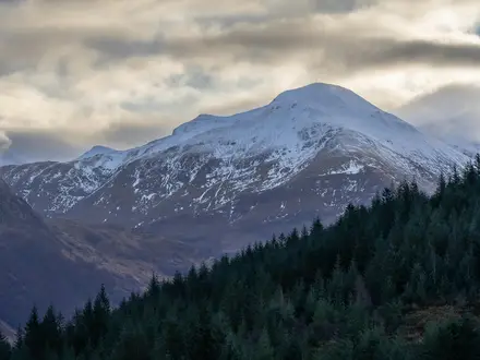
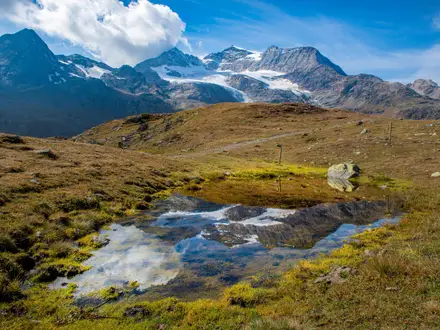
The Mare e Monti Nord is a hard, point-to-point multi-day trail in north-west Corsica, France, linking Calenzana with Cargèse over about 125 km in 10 days. Its name means “sea and mountains”, and that is accurate: the route alternates between coastal ridges, maquis, forest, granite paths, river valleys and villages. It suits fit walkers who want a strenuous Corsican trek without the alpine or technical demands of the GR20.
Route Overview
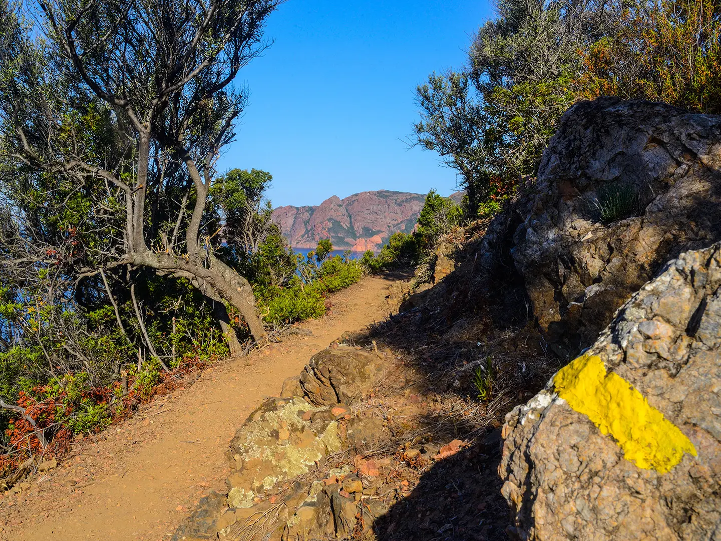
The route starts in Calenzana, about 12 km inland from Calvi and also the start village of the GR20, then runs south through Bonifatu, Tuarelli, Galeria, Girolata, Curzu, Serriera, Ota, Marignana and E Case/Revinda to finish at the coastal village of Cargèse. It is a linear trail, waymarked with orange paint stripes and sometimes marked TMM. Stages use old mule tracks, rocky paths and village-to-village gîte accommodation. For other mountain walking in France, compare the Cirque de Gavarnie Trails or the Chartreuse Trail GR9 segment.
Old Mule Tracks Between Corsica’s Coast and Interior
The Mare e Monti and Mare a Mare network was developed by the Parc Naturel Régional de Corse to connect mountain villages with coastal bays. The trail revives old mule tracks once used to move chestnuts, olives, wine and other goods between the interior and the coast. Along the way, Genoese-era towers, stone bridges and terraced villages reflect Corsica’s Pisan and Genoese heritage, while Calenzana links the route to the better-known GR20.
Notable highlights
- Scandola Nature Reserve: A UNESCO World Heritage marine and nature reserve. The trail crosses a wooded ridge around the Galeria to Girolata stage with views over the protected Scandola promontory; the reserve itself is accessed by boat.
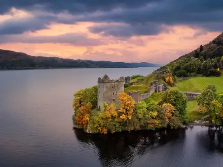
- Girolata: A largely seasonal fishing village reached only on foot or by boat. Its sheltered bay and 16th-century Genoese fort make it one of the route’s most memorable overnight stops.
- Spelunca Gorge: A wild gorge near Ota and Evisa, crossed on ancient mule paths. It is known for Genoese stone bridges, clear river pools and a steep ascent of about 650 m towards Evisa on itineraries using that variant.
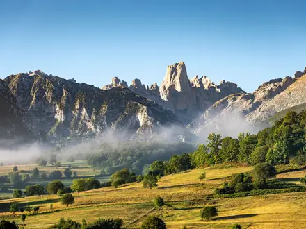
- Calanche de Piana: UNESCO-listed red and ochre granite formations above the Gulf of Porto. They sit near the southern section of the route and are a key landscape marker for hikers.
- Aitone / Laricio pine forest: Ancient Corsican Laricio pine and chestnut woodland in the Evisa area. It gives cooler, shaded walking compared with the exposed coastal maquis.
- Bonifatu forest: An early-stage forest of pine and holm oak in the Cirque de Bonifatu. It is reached on the first day from Calenzana and introduces the route’s forested terrain.
Challenges to expect
Expect a strenuous 10-day walk with about 7,000 m of cumulative ascent, steep rocky paths, stony descents and some exposed sections. Waymarking is by orange paint stripes, but terrain is remote enough to require careful navigation. Summer can bring intense heat and afternoon thunderstorms, while winter accommodation is scarce. Gîtes d’étape are the main overnight option, often with demi-pension.
HikeList Score
Mare e Monti Trail scored 82/100 on HikeList's trail-quality metrics.
See score breakdownHide breakdown
- Ideal length 94
- Balanced challenge 80
- Scenery & wildness 98
- Varied terrain 76
- Accommodation 58
- Food & support 65
- Path quality 98
- Season flexibility 89
Computed from length, challenge, scenery & wildness, terrain variety, accommodation, food & support, path quality and season flexibility.
Show more data Show less
- Mountainous
- Coastal
- Forest
- Rocky
- Dirt
- Huts
- Campsites
- Family Friendly
- Pet Friendly
- Water Sources
- Campsites
- Shelters
Photos from hikers
Taken on the trail by people who've reviewed Mare e Monti Trail.
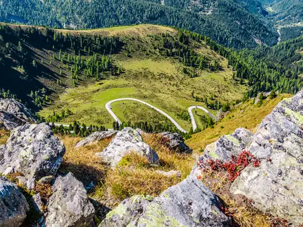
Start in Calenzana, the Balagne village where the GR20 also begins, and walk into the Bonifatu forest area on orange-marked paths.
Continue through forested and mountainous terrain, using dirt mule tracks and rocky paths towards Tuarelli.
The route moves towards the coast and the village of Galeria, with changing terrain between valleys, maquis and ridges.
Cross a wooded ridge with views towards the Scandola Nature Reserve before descending to Girolata, reachable only on foot or by boat.
Leave the sheltered bay of Girolata and continue over coastal and mountain terrain towards Curzu.
Follow orange waymarks through maquis, forest and rocky paths to the village of Serriera.
Walk towards Ota, a key village near the Spelunca Gorge and the Gulf of Porto area.
Continue inland on old tracks and mountain paths from Ota to Marignana; some itineraries in this area detour via Evisa and the Spelunca Gorge.
Head south through the final mountain-village section towards E Case/Revinda.
Complete the point-to-point route at Cargèse, a coastal village south of the Gulf of Porto.
Reviews
How would you rate Mare e Monti Trail?
Tap a star to start your review — you could be the first.