Sentiero Monte Tamaro
How would you rate Sentiero Monte Tamaro?
Tap a star to share your experience and help other hikers.
Sentiero Monte Tamaro: Monte Tamaro to Monte Lema Ridge Traverse
HikeList Score
Sentiero Monte Tamaro scored 77/100 on HikeList's trail-quality metrics.
See score breakdownHide breakdown
- Ideal length 55
- Balanced challenge 80
- Scenery & wildness 85
- Varied terrain 83
- Accommodation 66
- Food & support 88
- Path quality 98
- Season flexibility 76
Computed from length, challenge, scenery & wildness, terrain variety, accommodation, food & support, path quality and season flexibility.
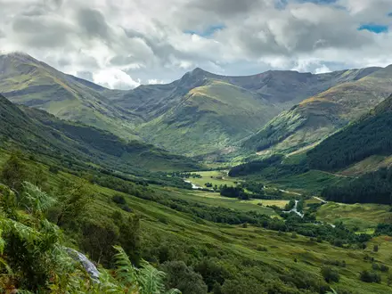
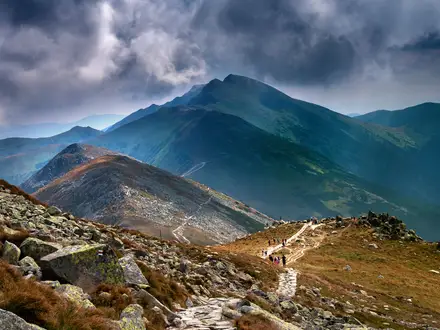
Sentiero Monte Tamaro is the classic Monte Tamaro–Monte Lema ridge traverse in Ticino, southern Switzerland. It is a 12.6–13 km point-to-point mountain hike, usually done in one day, with about 750 m of ascent and a highest point of 1,962 m on Monte Tamaro. The route is graded T2 but is best treated as hard because it is long, exposed, mostly unshaded and follows an open border ridge. It suits fit hikers who want big Lugano Prealps views without a multi-day commitment.
Route Overview
The usual direction is Alpe Foppa to Monte Lema. Start by taking the gondola from Rivera, near Monte Ceneri, to Alpe Foppa at 1,530 m. From there the path climbs past Capanna Tamaro to Monte Tamaro, then follows the crest over or around Monte Gradiccioli, Bassa di Indemini, Monte Pola and Monte Magno before finishing at Monte Lema, 1,624 m above Miglieglia. A cable car descends from Monte Lema to Miglieglia, with shuttle or public transport links back towards Rivera. For another Ticino panorama walk, compare the Cardada Cimetta Panorama Trail; for a much longer Swiss crossing, see the Alpine Pass Route (Route 6).
Modern Architecture and Old Border Country
Alpe Foppa is known for Santa Maria degli Angeli, a porphyry mountain chapel designed by Ticinese architect Mario Botta and built between 1992 and 1996. Its ramp and panoramic terrace make it a notable cultural stop before the ridge walk begins. The Alpe Foppa cable car first opened in 1972, making this high traverse practical as a lift-served day hike. Beyond the chapel, the ridge follows old pastoral and border country long used by shepherds.
Notable highlights
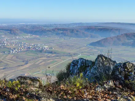
- Monte Tamaro summit (1,962 m): The high point comes early in the walk after the climb from Alpe Foppa. It gives broad views towards Lake Maggiore, Locarno, the Verzasca and Maggia valleys, Bellinzona, Lake Lugano and, in clear weather, the wider Alpine skyline.
- Santa Maria degli Angeli chapel: Mario Botta’s porphyry chapel at Alpe Foppa sits at the trailhead, not on the summit. Its stepped ramp, panoramic terrace and frescoes by Enzo Cucchi make it a worthwhile stop before starting the ridge.
- Switzerland–Italy border ridge: Much of the route follows the crest dividing Ticino from Italy. The walking is open and panoramic, with constant views both north and south.
- Capanna Tamaro: This mountain hut and restaurant lies a short way from Alpe Foppa. It is the natural early refuelling point before the long, exposed section towards Monte Lema.
- Monte Lema finish: The route ends at Monte Lema above the Malcantone, where there is a mountain restaurant, lookout terrace, weather-radar observatory and cable car down to Miglieglia.
Challenges to expect
Expect a sustained day rather than a technical climb. The path is a T2 white-red-white mountain trail, but the 13 km distance, exposed ridge, steep drop-offs, loose stone and very limited shade make it demanding. In hot weather there is little shelter. Carry water, check cable-car operating times, and watch for livestock guardian dogs between Bassa di Indemini and Monte Pola. Optional summit detours add roughly an hour.
HikeList Score
Sentiero Monte Tamaro scored 77/100 on HikeList's trail-quality metrics.
See score breakdownHide breakdown
- Ideal length 55
- Balanced challenge 80
- Scenery & wildness 85
- Varied terrain 83
- Accommodation 66
- Food & support 88
- Path quality 98
- Season flexibility 76
Computed from length, challenge, scenery & wildness, terrain variety, accommodation, food & support, path quality and season flexibility.
Show more data Show less
- Mountainous
- Alpine Pasture
- Ridge
- Rocky
- Gravel
- Dirt
- Huts
- Hotels
- Family Friendly
- Pet Friendly
- Restrooms
- Water Sources
- Shelters
- Picnic Areas
Photos from hikers
Taken on the trail by people who've reviewed Sentiero Monte Tamaro.
Reviews
How would you rate Sentiero Monte Tamaro?
Tap a star to start your review — you could be the first.