Pennine Way
How would you rate Pennine Way?
Tap a star to share your experience and help other hikers.
Pennine Way: A Complete Hiking Guide
HikeList Score
Pennine Way scored 82/100 on HikeList's trail-quality metrics.
See score breakdownHide breakdown
- Ideal length 80
- Balanced challenge 56
- Scenery & wildness 85
- Varied terrain 83
- Accommodation 92
- Food & support 94
- Path quality 98
- Season flexibility 89
Computed from length, challenge, scenery & wildness, terrain variety, accommodation, food & support, path quality and season flexibility.
The Pennine Way is a 431 km point-to-point National Trail from Edale in the Peak District to Kirk Yetholm in the Scottish Borders. Usually walked northbound over 16-19 days, it follows the Pennine hills through Derbyshire, Yorkshire, Durham, Cumbria and Northumberland. This is a strenuous upland route for experienced walkers: expect bog, exposed moorland, rocky fell tops and long remote sections. It is one of the defining long-distance hikes in England, tougher and wilder than coastal routes such as the Anglesey Coastal Path.
Route Overview
Most hikers start in Edale and walk north to Kirk Yetholm, following the National Trail acorn waymarks. The line climbs Kinder Scout, crosses the Dark Peak moors past Bleaklow and Standedge, then reaches Calderdale and the Yorkshire Dales via Malham Cove, Pen-y-ghent, Horton-in-Ribblesdale and Hawes. North of Keld it passes the Tan Hill Inn, Bowes/Stainmore, Middleton-in-Teesdale, High Force, Cauldron Snout, High Cup Nick and Dufton before crossing Cross Fell to Alston. The final third continues to Greenhead, Hadrian's Wall, Wark Forest, Bellingham and Byrness, then over the Cheviot ridge to the finish. It is a linear trail, so plan separate transport back from Kirk Yetholm.
History of the Pennine Way
The Pennine Way was proposed by journalist and rambler Tom Stephenson in a 1935 Daily Herald article calling for a “long green trail” along the Pennines. Its creation followed decades of access campaigning, including the 1932 Kinder Scout Mass Trespass. The route opened on Malham Moor on 24 April 1965 as Britain's first official National Trail. It also crosses older working and frontier landscapes, including Hadrian's Wall, lead-mining areas, drove roads and Pennine wool and farming country.
Notable highlights
- Kinder Scout (636 m): The high gritstone plateau above Edale is the Pennine Way's opening climb and the highest point in the Peak District. It is also linked to the 1932 Mass Trespass, a landmark moment in public access history.
- Malham Cove (about 80 m): A huge curved limestone cliff in the Yorkshire Dales, climbed by the Way to reach the limestone pavement above. Peregrine falcons nest on the crag.
- Pen-y-ghent (694 m): One of the Yorkshire Three Peaks, with a distinctive stepped profile of gritstone over limestone. The trail crosses it between Malham and Horton-in-Ribblesdale.
- High Force and High Cup Nick: In Teesdale, the route passes close above High Force, where the River Tees drops over Whin Sill dolerite, then climbs towards the dramatic U-shaped valley of High Cup Nick.
- Cross Fell (893 m): The highest point on the Pennine Way and the highest summit in the Pennines. It is broad, exposed and known for the bitter Helm Wind.
- Hadrian's Wall: The Way joins this UNESCO World Heritage Site for a memorable section along the Roman frontier before turning north into Northumberland.
Challenges to expect
The Pennine Way is strenuous because the difficulty is cumulative: repeated climbs, around 12,000 m of ascent, wet peat moorland, exposed high ground and long gaps between settlements. Waymarking uses the National Trail acorn, but mist, winter snow and boggy ground can still slow progress. Accommodation is available in villages, but remote stretches require advance planning. For a shorter upland comparison, see the Beacons Way; for a Scottish border-area option, see the Annandale Way.
HikeList Score
Pennine Way scored 82/100 on HikeList's trail-quality metrics.
See score breakdownHide breakdown
- Ideal length 80
- Balanced challenge 56
- Scenery & wildness 85
- Varied terrain 83
- Accommodation 92
- Food & support 94
- Path quality 98
- Season flexibility 89
Computed from length, challenge, scenery & wildness, terrain variety, accommodation, food & support, path quality and season flexibility.
 United Kingdom
 England
Show more data Show less
- Mountainous
- Grassland
- Forest
- Dirt
- Rocky
- Muddy
- Guesthouses
- Campsites
- Hostels
- Wild Camping Spots
- Bothies
- Family Friendly
- Dog Friendly On Leash
- Restrooms
- Non Potable Water Sources
- Established Campsites
- Shelters
- Picnic Areas
- Public Transport Access Points
Download Our Full Guide to Pennine Way FREE!
Get our comprehensive guide to this hike for free. Save it for later reading or print out at home.
Articles related to this hike
In these collections
Photos from hikers
Taken on the trail by people who've reviewed Pennine Way.
Pennine Way: The Complete Guide
 i
Image by petejeff
i
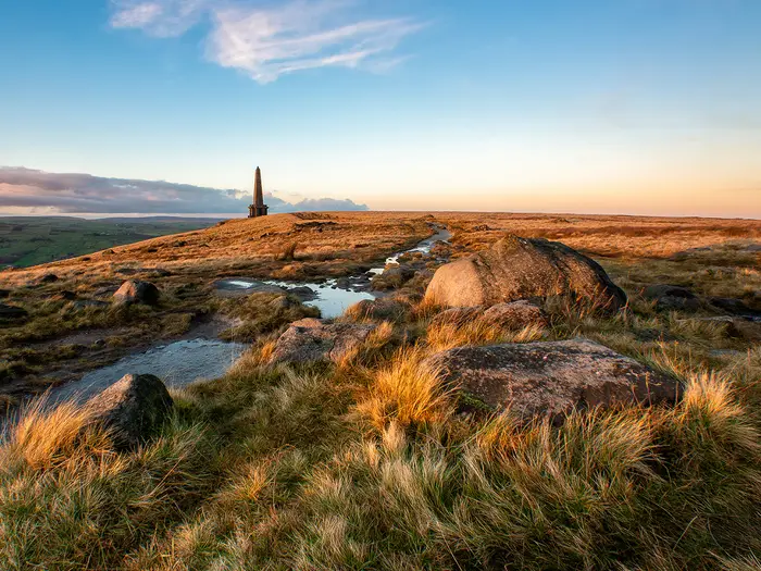
Image by petejeff The Pennine Way is Britain’s original National Trail: a 431 km line over the Pennine hills from Edale in the Peak District to Kirk Yetholm just over the Scottish border. It suits fit, experienced walkers who want a serious upland journey rather than a gentle village-to-village stroll.
The route starts hard, climbing onto Kinder Scout before crossing the wet peat and gritstone moors of the Dark Peak. Further north it changes character through Malham’s limestone, Pen-y-ghent, the high Dales, Teesdale waterfalls and the great sweep of High Cup Nick.
The hardest days are often the cumulative ones: long distances, repeated climbs, exposed fell tops, boggy ground and remote gaps between services. Cross Fell, the highest point at 893 m, and the final Cheviot crossing both demand proper weather judgement and confident navigation in mist.
There is no technical climbing, and the National Trail acorn waymarks help throughout, but this is not a first long-distance walk. Accommodation, resupply and transport need planning well ahead, especially around Tan Hill, Byrness and the facility-free approach to Kirk Yetholm.
This guide covers stages, days, accommodation, food, transport, terrain and the common mistakes that catch out Pennine Way walkers.
Stage-by-Stage Guide
Distances are approximate. The Pennine Way is waymarked with National Trail acorns, but these stage notes are not a substitute for OS mapping, a guidebook or a reliable GPX, especially on the Dark Peak, Cross Fell and the Cheviots.
Stage 1: Edale to Crowden — approx. 26 km
The opening day is a hard introduction, climbing straight from Edale onto Kinder Scout and crossing some of the most characteristic Dark Peak ground on the whole trail. The route passes Kinder Downfall and continues over high, exposed moorland towards Bleaklow before descending to Crowden.
Expect peat, gritstone, wet ground and groughs, even where flagstones have improved the worst sections. In mist, the plateau terrain can feel directionless, so keep map and compass or GPS to hand rather than relying only on waymarks.
Food and water should be sorted in Edale before starting; do not assume useful services once committed to the moors. Crowden is a practical stopping point on this itinerary, but accommodation is limited enough that it should be booked well ahead.
Edale has its own railway station on the Manchester–Sheffield Hope Valley line, making it the easiest point on the trail to reach by public transport. Crowden should be treated mainly as an overnight stop rather than a transport hub; onward travel or pick-up arrangements should be checked before travelling.
Stage 2: Crowden to Standedge — approx. 21 km
This is another moorland stage, leaving Crowden for the high peat of the northern Dark Peak and crossing Black Hill before reaching Standedge. It is shorter than the first day, but still serious in poor visibility or prolonged rain.
The ground can be saturated and slow, with paved sections helping but not removing the boggy character of the route. Black Hill is exposed and can be bleak in wind, low cloud or winter conditions.
Carry food and enough water from Crowden, and treat any upland water before drinking. Standedge is a stopping point rather than a large settlement, so overnight logistics, meals and any transport connection need arranging in advance.
Navigation is usually helped by the National Trail line and flagstones, but mist can make the broad moorland confusing. Check the weather before leaving Crowden and avoid underestimating this stage because of its shorter distance.
Stage 3: Standedge to Hebden Bridge — approx. 24 km
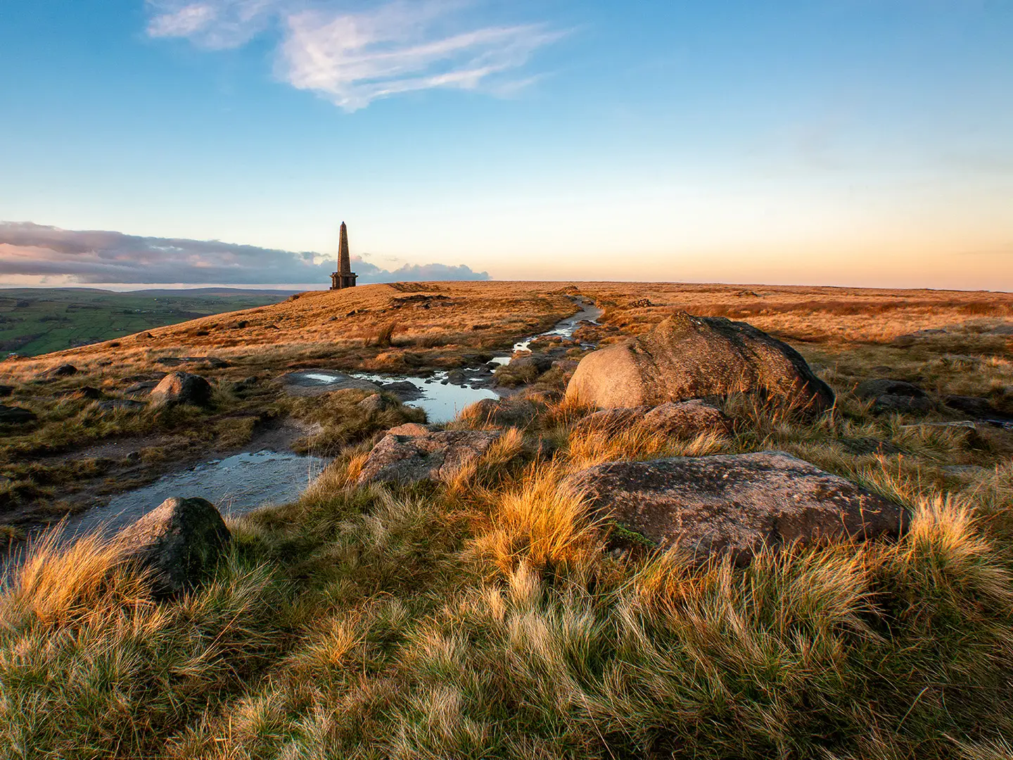
From Standedge the Way continues across South Pennine moorland towards the Calder valley. Stoodley Pike is the defining landmark of the day, standing high above Hebden Bridge and visible from a wide area in clear weather.
The walking mixes exposed moor, gritstone country and rough upland paths. Wet ground and mud remain normal features, though this stage begins to feel less like the deep peat crossings of Kinder and Bleaklow.
Food and water options should be checked before leaving Standedge; carrying a full day’s provisions is the safest plan. Hebden Bridge is a useful overnight base with a broader choice of accommodation than the preceding moorland stops, but beds still need booking during the main walking season.
Hebden Bridge is one of the better intermediate access points on the route, with rail or bus links useful for section walkers. The descent towards the Calder valley can be a relief after the open moors, but do not let the proximity of a town replace proper navigation on the approach.
Stage 4: Hebden Bridge to Gargrave — approx. 29 km
This is a long South Pennines-to-Dales transition stage, leaving Hebden Bridge and passing through the Colden area before continuing towards Gargrave. It is less defined by a single summit or monument than the previous days, but the distance makes it a substantial day.
Expect a mixture of moorland, field paths, tracks and wet upland going. Conditions underfoot can still be muddy, and the cumulative fatigue of the first few days often starts to show here.
Start with enough food and water for the day, as intermediate services should not be relied on without checking opening times and exact route access. Gargrave is a practical village stop with accommodation, but availability should be secured before starting the trail.
Hebden Bridge offers useful public transport access at the start of the stage. For Gargrave, local transport and onward connections should be checked before travelling, particularly if using it as a section end.
Stage 5: Gargrave to Malham — approx. 12 km
This is a deliberately shorter stage and a useful recovery day after the longer South Pennine mileage. The route heads into the limestone country of the Yorkshire Dales, finishing at Malham before the more demanding Malham-to-Horton crossing.
The terrain is generally less severe than the high peat moors, but paths can still be muddy after rain. The day is best used to dry kit, restock and arrive early enough to prepare for the next stage over Fountains Fell and Pen-y-ghent.
Gargrave and Malham are both sensible food and accommodation points, but small-village opening times and bed availability should always be checked before travelling. Do not assume late food or shop access without confirming it.
Public transport and road access for either village should be checked if joining or leaving the trail here. Navigation is usually more straightforward than on the Dark Peak, but the National Trail still crosses working farmland, so gates, livestock and dogs on leads need careful handling.
Stage 6: Malham to Horton-in-Ribblesdale — approx. 24 km
This is one of the classic Pennine Way stages, leaving Malham for Malham Cove, the limestone pavement above it, Malham Tarn, Fountains Fell and Pen-y-ghent. The contrast with the Dark Peak is strong: limestone, open Dales fell and one of the Yorkshire Three Peaks all come in a single day.
The climb by Malham Cove is steep and the limestone pavement can be awkward or slippery when wet. Pen-y-ghent is the day’s main physical test, with a steep stepped profile that is close to a scramble in places before the descent to Horton-in-Ribblesdale.
Carry food from Malham and do not rely on water being conveniently available on the high ground. Horton-in-Ribblesdale is a key overnight halt and one of the route’s useful public transport points, with rail or bus links for staged walks.
Navigation over the open fell sections still matters, especially in mist around Fountains Fell and Pen-y-ghent. In poor weather, allow extra time and keep waterproofs accessible rather than buried in the pack.
Stage 7: Horton-in-Ribblesdale to Hawes — approx. 23 km
This stage links two important Yorkshire Dales stopping points, leaving Horton-in-Ribblesdale and continuing north towards Hawes. It is a quieter day than the Malham and Pen-y-ghent stage, but still involves open upland walking and the usual Pennine exposure.
The ground can be wet and tiring, particularly after sustained rain. Treat it as a full hill day rather than a valley transfer, with navigation still needed if cloud drops onto the fells.
Horton-in-Ribblesdale is a useful place to restock before leaving. Hawes is another practical trail base with accommodation and rail or bus links in the wider transport pattern of the route, but bookings should be made ahead.
There are no major technical difficulties on this stage, but the warning is cumulative: seven days in, small foot problems, wet socks and poor pacing can become serious. Use Hawes for food, laundry, drying kit or replacing minor gear if available; current services should be checked before relying on them.
Stage 8: Hawes to Tan Hill Inn — approx. 28 km
From Hawes the Way climbs over Great Shunner Fell to Thwaite, continues through Keld and then pushes out onto the moor to Tan Hill Inn. It is a memorable stage because it finishes at the highest pub in Britain, standing alone on the Pennine Way at 528 m.
Great Shunner Fell is broad and exposed, with weather often more important than the technical difficulty of the path. The later approach to Tan Hill feels remote, and wind, rain or low cloud can make the final kilometres slow.
Hawes is the best place to leave with a full day’s food. Thwaite and Keld are named route settlements, but any food, drink or accommodation availability there should be checked before travelling rather than assumed.
Accommodation at or near Tan Hill is limited by its isolated position, so booking early is essential. Public transport options are not the reason to finish here; plan it as a booked overnight stop or have a pre-arranged alternative.
Stage 9: Tan Hill Inn to Middleton-in-Teesdale — approx. 27 km
This stage leaves the isolation of Tan Hill and heads across moorland towards Middleton-in-Teesdale. It is a long, exposed day without the immediate drama of Pen-y-ghent or Cross Fell, but it demands steady pacing and self-sufficiency.
The terrain is typical Pennine high ground: wet, open and potentially slow in poor conditions. Flagstones may help in places, but bog and waterlogged ground remain part of the route’s character.
Start from Tan Hill with food and enough water for the day. Middleton-in-Teesdale is the next substantial overnight stop on this itinerary, with accommodation and services that should be booked or checked in advance.
Navigation is generally not complex in good visibility, but low cloud on broad moorland can make the line harder to hold. This is a day to keep breaks efficient and avoid arriving late if weather is deteriorating.
Stage 10: Middleton-in-Teesdale to Dufton — approx. 33 km
This is one of the most varied and rewarding stages, following the River Tees past Low Force and High Force before continuing to Cauldron Snout, High Cup Nick and the descent to Dufton. It is also long, so the major highlights should not distract from the distance still to cover.
The riverside sections can be slippery, especially near waterfalls and on wet rock. Cauldron Snout is passed by a rough, scrambling section, and the later approach to High Cup Nick returns the route to high, exposed Pennine ground.
Food and water should be carried from Middleton-in-Teesdale, with any intermediate refreshment treated as a bonus only if checked in advance. Dufton is the logical overnight stop before Cross Fell, and accommodation should be secured before committing to the stage.
Navigation beside the Tees is usually more contained than on the open moors, but mist and bad weather matter again around High Cup. Take particular care near steep or wet ground at the waterfalls and High Cup Nick, and allow enough time for the 33 km distance.
Stage 11: Dufton to Alston — approx. 32 km
This is the highest and most serious stage of the route, crossing Great Dun Fell and Cross Fell before descending via Garrigill towards Alston. Cross Fell, at 893 m, is both the Pennine Way’s high point and the highest summit in the Pennines.
The ground is broad, high and exposed, with little shelter. Cross Fell is notorious for the Helm Wind on its south-west slope, and snow, mist or strong wind can turn this stage into a major undertaking.
Leave Dufton with enough food and water for a long fell day. Garrigill is passed before Alston, but any food or drink availability should be checked before travelling; Alston is the secure end-of-stage base and one of the route’s useful transport access points.
Navigation must be taken seriously here. In poor visibility the broad tops can be disorientating, so carry OS mapping, compass and a reliable GPS track, and be prepared to delay the stage if the forecast is severe.
Stage 12: Alston to Greenhead — approx. 25 km
This stage leaves the North Pennines around Alston and heads towards Greenhead, setting up the following day on Hadrian’s Wall. It is a more moderate distance than the Cross Fell day, but it still sits within an upland, weather-exposed section of the route.
Expect a mixture of paths, tracks and wet rural ground rather than a simple lowland walk. After heavy rain, mud and slow going are realistic planning assumptions.
Alston is the best place to sort food before starting. Greenhead is an important access point on the itinerary, with rail or bus links in the wider transport pattern of the trail, and accommodation should be booked ahead.
Navigation is usually less committing than on Cross Fell, but fatigue after the previous stage is a genuine risk. Use this day to reset pace, dry kit where possible and avoid carrying small injuries into the longer Hadrian’s Wall stage.
Stage 13: Greenhead to Bellingham — approx. 37 km
This is a long day with a major change of character: the Way joins Hadrian’s Wall around the Steel Rigg and Housesteads section before turning north into Northumberland towards Bellingham. The wall section is one of the most distinctive parts of the entire trail, combining Roman frontier remains with dramatic clifftop walking.
The first part of the day is likely to feel more structured than the open Pennine moors, but the full 37 km makes it demanding. After leaving the Hadrian’s Wall corridor, the route heads into quieter country including Wark Forest before the approach to Bellingham.
Carry enough food and water for a long day; do not rely on services once away from the main visitor areas unless they have been checked before travelling. Bellingham is the overnight target and should be booked ahead, particularly because the next stop at Byrness is remote.
Greenhead is a useful public transport access point. Navigation along the wall section is usually helped by the clear line of the route, but the later countryside is quieter, and tired walkers should take care not to lose time through small route-finding errors.
Stage 14: Bellingham to Byrness — approx. 25 km
This stage is the approach to the Cheviots and should be planned with the final crossing firmly in mind. The walking heads through increasingly remote Northumberland country towards Byrness, the last overnight stop before Kirk Yetholm on this itinerary.
Terrain is a mix of rural paths, forestry and open ground, with wet and muddy conditions possible. Although the distance is not extreme by Pennine Way standards, it is important to arrive in Byrness with enough energy, food planning and weather information for the final stage.
Bellingham is the place to stock up before leaving. Byrness has very limited onward options compared with larger villages, so accommodation, evening food and breakfast or packed-lunch arrangements must be organised well in advance.
Public transport or road access at Byrness should be checked before travelling, especially for section walkers. Navigation is mainly about staying disciplined and not treating this as a rest day; the Cheviot crossing begins immediately after this stop.
Stage 15: Byrness to Kirk Yetholm — approx. 43 km
The final stage crosses the remote Cheviots along the England–Scotland border before dropping to Kirk Yetholm. It passes Windy Gyle, with an optional spur to The Cheviot, and has no settlements en route before the finish.
This is one of the toughest days on the Pennine Way: long, high, exposed and facility-free. The route is not technically difficult, but weather, wind, mist, boggy ground and the sheer distance make it a serious undertaking.
Carry all food needed for the day and enough water, and know how water will be managed before leaving Byrness. Basic mountain refuge huts exist on the Cheviot section, but they are not a substitute for a booked bed or a guaranteed service; many walkers split the crossing or drop off-ridge to accommodation, which must be planned in advance.
Navigation is critical in poor visibility, even with waymarks. The optional spur to The Cheviot adds commitment to an already long day, so only include it if conditions, daylight and fitness allow.
The Pennine Way finishes on the village green outside the Border Hotel in Kirk Yetholm, just over the England–Scotland border. There is no railway at the finish; onward travel is by bus to Kelso and then on towards Berwick-upon-Tweed or Newcastle, and current timetables should be checked before travelling.
Recommended Itinerary
Distances below use the stage figures in the route brief. Treat them as planning distances rather than booking measurements: check official mapping before booking accommodation, especially where a stage is split or uses off-route accommodation.
Standard itinerary: 16 days
This is the most sensible version for many fit end-to-end walkers: it follows the common Pennine Way staging hubs but avoids making the final Cheviot crossing a single 43 km day. It still contains several long, exposed stages and should not be treated as an easy schedule.
| Day | From | To | Approx. distance | Why this stage makes sense | Services/accommodation notes |
|---|---|---|---|---|---|
| 1 | Edale | Crowden | 26 km | A full opening day over Kinder Scout, Kinder Downfall and the Dark Peak moors, finishing at the first practical stop after Bleaklow. | Edale is straightforward to reach by rail. Crowden is a key first-night stop; book ahead rather than assuming flexibility. |
| 2 | Crowden | Standedge | 21 km | Keeps the second day shorter after the hard Dark Peak start, while crossing Black Hill and continuing towards the South Pennines. | Accommodation may be at or near Standedge rather than in a large trail town. Check the exact location before committing. |
| 3 | Standedge | Hebden Bridge | 24 km | A manageable South Pennines stage, with Stoodley Pike providing a clear landmark before the descent towards the Calder valley. | Hebden Bridge is one of the better resupply and transport points on the route. It is a useful place to replace kit or adjust plans. |
| 4 | Hebden Bridge | Gargrave | 29 km | A long but logical push north towards the Yorkshire Dales, reaching an established overnight stop before the Malham section. | This is one of the longer early stages. Book accommodation in Gargrave ahead and check food options before arrival. |
| 5 | Gargrave | Malham | 12 km | A deliberately short recovery day, useful after the long South Pennines stage and before the higher limestone country around Malham. | Malham is a popular walking village; accommodation can fill quickly in good weather and holiday periods. |
| 6 | Malham | Horton-in-Ribblesdale | 24 km | A classic Pennine Way day over Malham Cove, Malham Tarn, Fountains Fell and Pen-y-ghent before dropping to Horton-in-Ribblesdale. | Horton-in-Ribblesdale has transport links and is a useful staging point. Expect this day to feel harder than the distance suggests. |
| 7 | Horton-in-Ribblesdale | Hawes | 23 km | A solid Dales stage linking Ribblesdale with Wensleydale, ending in one of the more useful service centres on the route. | Hawes is an important resupply and accommodation stop. It also has transport links for staged walkers. |
| 8 | Hawes | Tan Hill Inn | 28 km | Crosses Great Shunner Fell and continues through the upper Dales towards the isolated moorland stop at Tan Hill. | Tan Hill Inn is directly on the Pennine Way and stands alone on the moor. Book this night well ahead, as alternatives are not close together. |
| 9 | Tan Hill Inn | Middleton-in-Teesdale | 27 km | A remote-feeling transition from high moor into Teesdale, finishing in a practical village before the waterfalls and upper Tees section. | Do not rely on plentiful intermediate facilities. Middleton-in-Teesdale is the logical place to reset before a long following day. |
| 10 | Middleton-in-Teesdale | Dufton | 33 km | One of the great Pennine Way stages, following the River Tees past Low Force, High Force and Cauldron Snout before High Cup Nick and the descent to Dufton. | This is a long day with slow ground in places. Dufton accommodation should be booked early because it is the key stop before Cross Fell. |
| 11 | Dufton | Alston | 32 km | Crosses the high North Pennines over Great Dun Fell and Cross Fell, the highest point of the Pennine Way, before descending via Garrigill towards Alston. | This stage is very exposed in poor weather, especially around Cross Fell. Alston has transport links and is a useful recovery stop. |
| 12 | Alston | Greenhead | 25 km | A more moderate day after Cross Fell, moving north towards Hadrian’s Wall and the Roman frontier section. | Greenhead has transport links and is a practical staging point before the long day to Bellingham. |
| 13 | Greenhead | Bellingham | 37 km | A demanding but logical stage, taking in the Hadrian’s Wall section around Steel Rigg and Housesteads before turning north through more remote country. | This is one of the toughest standard-stage distances. Start early and have accommodation in Bellingham fixed before setting out. |
| 14 | Bellingham | Byrness | 25 km | Positions you at the foot of the Cheviots for the final crossing, rather than trying to approach it from farther south. | Byrness is a critical booking point. Accommodation and onward options are limited, so this night should be secured well in advance. |
| 15 | Byrness | Cheviots overnight option | Check official mapping before booking | Splits the otherwise very long Byrness to Kirk Yetholm crossing and gives more margin for weather, daylight and tired legs. | The Cheviots have no settlements en route. Basic mountain refuge huts exist, or some walkers arrange off-ridge accommodation; exact logistics must be checked before travelling. |
| 16 | Cheviots overnight option | Kirk Yetholm | Check official mapping before booking | Completes the remote border ridge past the Cheviot country and descends to the official finish at Kirk Yetholm. | Kirk Yetholm has no railway. Plan onward travel separately by bus connections towards Kelso and then Berwick-upon-Tweed or Newcastle. |
Slower variant: 17–19 days
A 17–19 day schedule suits walkers carrying camping gear, anyone wanting shorter days through the North Pennines and Cheviots, and those who prefer more bad-weather margin. It is also the better choice if accommodation availability forces off-route overnight stops.
Use the 16-day itinerary above as the base, then add one to three extra nights by splitting the hardest stages. The most useful stages to break are:
| Add a night around… | Why it helps | Planning note |
|---|---|---|
| Hebden Bridge to Gargrave | Reduces a long early Pennine stage before the Yorkshire Dales. | Exact split points depend on available beds or camping. Check official mapping before booking. |
| Middleton-in-Teesdale to Dufton | Breaks the 33 km Teesdale, Cauldron Snout and High Cup Nick day, which can be slow despite being well worth taking time over. | Do not assume services between the main settlements. This should be checked before travelling. |
| Dufton to Alston | Gives more flexibility for the Cross Fell crossing, where exposure, mist and the Helm Wind can make progress slow. | Any split must be planned carefully because high-level accommodation options are limited. Check before booking. |
| Greenhead to Bellingham | Reduces the 37 km day after Hadrian’s Wall and before the final Northumberland stages. | Accommodation may require leaving the line of the trail. Check official mapping and transport before booking. |
| Byrness to Kirk Yetholm | The most important split for many walkers, avoiding a single 43 km facility-free Cheviot crossing. | Basic mountain refuge huts exist, but they are not a substitute for a full accommodation plan. Check current arrangements before travelling. |
Faster variant: 15 days
A 15-day Pennine Way is possible by walking the stage list straight through and taking the final Byrness to Kirk Yetholm leg in one 43 km day. This suits very fit, efficient walkers with light packs, long daylight hours and settled weather.
The faster version is not recommended as a default plan. The final Cheviot day has no settlements en route, and earlier long stages such as Middleton-in-Teesdale to Dufton, Dufton to Alston and Greenhead to Bellingham already make the schedule demanding. If using the 15-day plan, book every remote night well ahead and keep a realistic fallback for bad weather.
Planning the Route
The Pennine Way is best planned around accommodation and exposed upland sections rather than around neat daily mileage. The trail passes through enough villages to make an end-to-end walk practical, but the spacing is uneven: several days are naturally short or moderate, while others become long because there is little useful accommodation in between.
Most end-to-end walkers should allow 16 to 19 days. A 15-day schedule is possible for strong, efficient walkers, but it creates several demanding days of 30 km or more and leaves little margin for bad weather, sore feet or transport disruption.
Choosing a pace
A faster itinerary suits walkers who are already comfortable with repeated long days over wet, exposed ground and who are using pre-booked accommodation or baggage transfer. It is not the best way to experience the route if this is a first major upland trail, because the Pennine Way’s difficulty is cumulative rather than technical.
A slower 18- or 19-day plan is usually more robust. It gives more flexibility around the Dark Peak peat, the North Pennines high fells and the final Cheviot crossing, and makes it easier to fit available beds in small places such as Tan Hill, Byrness and the remote northern section.
Rest days are not essential, but building in one spare day is sensible if travelling a long way to the start or walking outside settled summer weather. Bad conditions on Cross Fell or in The Cheviots can turn a hard day into a serious navigation exercise.
How stages are dictated by accommodation
Daily stages are strongly shaped by where walkers can sleep. The Pennine Way crosses long stretches of moorland, fell and forest with few settlements, so accommodation should be booked before transport is finalised.
The main pressure points are:
| Section | Planning issue | Practical approach |
|---|---|---|
| Edale to Hebden Bridge | Early high moorland over Kinder Scout, Bleaklow and Black Hill can be slow in poor weather. | Avoid overloading the first two days; start with a realistic pace rather than trying to “make up time” immediately. |
| Malham to Horton-in-Ribblesdale | Limestone terrain, Fountains Fell and the steep climb over Pen-y-ghent make this more than a simple village-to-village day. | Treat it as a proper upland stage and start with enough food, water and daylight. |
| Hawes to Tan Hill Inn and on to Middleton-in-Teesdale | Remote moorland and limited accommodation options around Tan Hill. | Book this part early and check any food or baggage arrangements directly before travelling. |
| Middleton-in-Teesdale to Dufton | A long stage including Teesdale, High Force, Cauldron Snout and the approach to High Cup Nick. | Plan a full day and do not assume there will be convenient services between the main overnight stops. |
| Dufton to Alston | Crosses Great Dun Fell and Cross Fell, the highest and most exposed ground on the route. | Keep a weather margin; Cross Fell is notorious for severe conditions, including the Helm Wind. |
| Greenhead to Bellingham | A long day after the Hadrian’s Wall section, followed by more remote Northumberland walking. | Check accommodation availability before committing to a fixed schedule. |
| Byrness to Kirk Yetholm | The final Cheviot crossing is around 43 km with no settlements en route. | Many walkers split it using a basic mountain refuge hut or by dropping off-ridge to accommodation; this should be planned in detail before travelling. |
Shortening or extending the walk
The easiest way to make the route more manageable is to add days, not to rely on cutting corners. Extra nights can reduce the longest stages and create better weather flexibility for Cross Fell and The Cheviots.
Shortening the walk usually means skipping a section by transport, which changes the nature of an end-to-end Pennine Way. For walkers with fixed annual leave, it is better to plan a clean section hike than to overcommit to a rushed full traverse.
The final Byrness to Kirk Yetholm stage deserves particular attention. If walking it in one day, it needs an early start, reliable navigation and enough food and water for a full remote hill day. If splitting it, the mountain refuge option is basic, and any off-ridge accommodation or transport should be checked before travelling.
Section hiking
Section hiking is practical, especially because several intermediate points have rail or bus links. Useful access points include Hebden Bridge, Horton-in-Ribblesdale, Hawes, Alston and Greenhead, with Edale served by its own railway station.
A sensible section-hiking approach is to divide the trail by landscape and transport access: the Peak District and South Pennines, the Yorkshire Dales, the North Pennines, Hadrian’s Wall and Northumberland, then the Cheviots to Kirk Yetholm. Current bus and train times should be checked before booking accommodation, particularly at the northern end.
Leaving the finish needs more planning than reaching the start. Kirk Yetholm has no railway station; onward travel is by bus to Kelso and then towards Berwick-upon-Tweed or Newcastle. This should be checked before travelling, especially on weekends or public holidays.
Key planning priorities
Accommodation: book early, especially in small villages and on remote sections. Tan Hill, Byrness and the Cheviot finish are the places where a casual approach is most likely to cause problems.
Food: do not assume that every overnight stop will have flexible food options or that daytime resupply will appear at convenient intervals. Carry enough food for the full day plus a reserve on the higher and more remote stages.
Water: carry enough between known settlements and accommodation points. Hill water should be treated if used, and dry or frozen conditions can make casual refills unreliable.
Navigation: the route is waymarked with National Trail acorns, but mist, snow, bog and open fell make map-and-compass skills important. The official National Trails map and GPX are useful, but paper mapping remains sensible for a route with this much exposed ground.
Relevant OS Explorer coverage includes OL1, OL21, OL2, OL30, OL31, OL5, OL43 and OL16. A dedicated Pennine Way guidebook can also help with stage planning, accommodation spacing and escape options.
Weather: mid-May to September is the normal planning window. Winter conditions on the high fells are serious and are only suitable for experienced walkers with appropriate winter judgement and equipment.
Transport: Edale is straightforward by train on the Manchester–Sheffield Hope Valley line. The finish at Kirk Yetholm requires onward bus planning, and all public transport links should be checked before travelling.
Baggage transfer: companies such as Sherpa Van offer Pennine Way baggage transfer. Coverage, pick-up points and accommodation compatibility should be confirmed before booking, as the remote stages can limit options.
Camping and basic shelters: campsites, camping barns, bothies and some wild camping can form part of a Pennine Way plan, but the details vary by place. Booking rules, access expectations and any camping permission should be checked before relying on them.
Towns, Villages and Overnight Stops
Accommodation planning is one of the main challenges on the Pennine Way. The trail links excellent walking country, but the useful overnight places are unevenly spaced and several stages finish at small settlements or isolated points where beds, food and onward transport can be limited.
Book the remote and low-supply stops first, especially around Crowden, Standedge, Tan Hill, Dufton, Byrness and Kirk Yetholm. Where a place is a practical staging point rather than a full-service town, do not arrive assuming there will be a spare bed, an evening meal or a shop.
| Route order | Place | Practical role |
|---|---|---|
| Start | Edale | Official start village; easiest access point by rail |
| Early Dark Peak | Crowden | First main overnight stop after Kinder Scout and Bleaklow |
| South Pennines | Standedge | Staging point between Crowden and Hebden Bridge |
| Calder valley | Hebden Bridge / Colden | Useful overnight and transport break |
| Yorkshire Dales approach | Gargrave | Good overnight before Malham |
| Yorkshire Dales | Malham | Key village stop below Malham Cove and Malham Tarn |
| Three Peaks area | Horton-in-Ribblesdale | Overnight stop after Pen-y-ghent; transport link |
| Wensleydale | Hawes | Major practical stop before Great Shunner Fell |
| Upper Swaledale | Thwaite / Keld | Small intermediate Dales settlements before Tan Hill |
| Open moor | Tan Hill Inn | Isolated high-level overnight stop directly on the Way |
| Teesdale | Middleton-in-Teesdale | Important service stop before the long Dufton stage |
| North Pennines | Dufton | Key village before Cross Fell |
| South Tyne valley | Garrigill / Alston | Alston is the main overnight and transport hub |
| Hadrian’s Wall area | Greenhead | Staging point before the Wall and Northumberland section |
| Northumberland | Bellingham | Main village stop before Byrness |
| Edge of The Cheviots | Byrness | Critical final staging point; very limited onward options |
| Finish | Kirk Yetholm | Finish village; no railway, onward bus required |
Edale
Edale is the official start of the Pennine Way, with the National Trail acorn waymarks leading out of the village towards Kinder Scout. It is a practical place to arrive the day before starting, especially if travelling by train.
The village has its own railway station on the Manchester–Sheffield Hope Valley line, making it one of the simplest long-distance trailheads in Britain to reach without a car. Accommodation and food should still be booked ahead, as it is a popular Peak District base and the first day to Crowden is a serious upland stage rather than a warm-up.
Crowden
Crowden is the first common overnight stop after the opening crossing of Kinder Scout, Kinder Downfall and Bleaklow. It is a functional stop rather than a large village, and it matters because the ground before and after it is high, wet and exposed.
Accommodation availability is limited compared with later town stops, so Crowden should be treated as an early priority booking. Food options and any camping or bunkhouse arrangements should be checked before travelling, particularly if walking outside the main summer season.
Standedge
Standedge works as a staging point between Crowden and Hebden Bridge, after the route has crossed the Black Hill area and moved into the South Pennines. It is useful for breaking the early moorland section into manageable days.
This is not a place to rely on for broad walk-in choice. Accommodation, evening meals, breakfast arrangements and any transport links should be checked before travelling, and many walkers will need to plan around exactly where their booked bed sits in relation to the trail.
Hebden Bridge and Colden
Hebden Bridge is one of the more useful breaks in the South Pennines, reached after the Standedge stage and before the longer push towards Gargrave. Colden sits on the route sequence above the Calder valley and is part of the same practical planning area for many walkers.
This is a sensible place for a reset: accommodation choice is typically better than at the smaller moorland stops, and it is one of the intermediate points with rail or bus links for staged walkers. Current public transport times should be checked before relying on them, especially if leaving or joining the trail here.
Gargrave
Gargrave is an important overnight stop on the approach to the Yorkshire Dales section proper. It breaks the long Hebden Bridge to Gargrave day from the shorter onward stage to Malham.
As a village stop, it is useful for accommodation, food and reorganisation before the limestone country around Malham and Pen-y-ghent. Book beds ahead and check shop or meal availability before arrival, as onward stages quickly return to more rural ground.
Malham
Malham is one of the key Pennine Way villages, positioned below Malham Cove, Malham Tarn, Fountains Fell and the onward crossing to Pen-y-ghent. It is a natural overnight stop because the next day to Horton-in-Ribblesdale includes significant limestone and fell walking rather than simple valley mileage.
Accommodation is in demand in good walking weather, so booking early is sensible. Food and packed-lunch arrangements should be made the evening before leaving, as the route over Fountains Fell and Pen-y-ghent is not a stage where walkers should depend on finding frequent services.
Horton-in-Ribblesdale
Horton-in-Ribblesdale is the usual stop after the Malham to Pen-y-ghent stage. It is a practical place to recover after the steep climb over one of the Yorkshire Three Peaks and to prepare for the next day to Hawes.
It is also one of the named intermediate access points with rail or bus links for section walkers. Timetables and service frequency should be checked before travelling, and accommodation should be booked rather than assumed.
Hawes
Hawes is one of the most important service stops in the middle section of the Pennine Way. It comes after the Horton-in-Ribblesdale stage and before the climb over Great Shunner Fell towards Thwaite, Keld and Tan Hill.
This is a good place to restock, wash kit where facilities allow, and sort food for the more exposed ground ahead. Hawes is also one of the intermediate places with rail or bus access for staged itineraries, but current services should be checked before building plans around them.
Thwaite and Keld
Thwaite and Keld are small Upper Swaledale settlements on the route between Hawes and Tan Hill. They are useful as possible intermediate stopping or escape points if the Hawes to Tan Hill stage feels too long, but they should not be treated as guaranteed full-service stops.
Any accommodation, food or baggage-transfer arrangements here need to be made in advance. These villages are especially useful for walkers who want to shorten the crossing from Hawes before continuing to the isolated Tan Hill Inn.
Tan Hill Inn
Tan Hill Inn is one of the most distinctive overnight stops on the Pennine Way: an isolated inn standing directly on the route north of Keld. At 528 m, it is the highest pub in Britain and is a major planning point because there is little else close at hand.
Book this stop well ahead if using it for accommodation. Because it is isolated and exposed, walkers should also check meal arrangements, opening details and any weather-related access issues before travelling.
Middleton-in-Teesdale
Middleton-in-Teesdale is the next major overnight stop after Tan Hill and is a valuable base before the long Teesdale stage to Dufton. The route beyond passes Low Force, High Force, Cauldron Snout and High Cup Nick, making it one of the most impressive but also one of the longer days in the standard itinerary.
Use Middleton-in-Teesdale to sort food, packed lunches and any kit issues before leaving the valley. Accommodation should be booked ahead, particularly because the onward day is long enough that starting late after searching for supplies is a poor plan.
Dufton
Dufton is a key Pennine Way village at the foot of the North Pennines crossing. It is the normal overnight stop before the route climbs towards Great Dun Fell and Cross Fell, the highest point of the trail.
This is a high-priority booking because the next section is serious, exposed fell walking and poor weather can make progress slow. Evening meal, breakfast and packed-lunch options should be arranged in advance rather than left until arrival.
Garrigill and Alston
Garrigill comes after the Cross Fell descent, while Alston is the main practical overnight hub for this part of the route. Many itineraries use Alston as the end of the Dufton stage and the start of the next day towards Greenhead.
Alston is one of the named intermediate places with rail or bus links for section walkers, making it useful for joining, leaving or pausing the trail. Current transport details should be checked before travelling, and accommodation should still be booked ahead during the walking season.
Greenhead
Greenhead is the staging point before the Hadrian’s Wall section around Steel Rigg and Housesteads. It is also one of the intermediate access points with rail or bus links, which makes it useful for section hiking and itinerary adjustments.
The following stage to Bellingham is long in the standard schedule, so Greenhead is a place to leave well supplied and well rested. Check accommodation, food and transport details before relying on them, particularly if arriving late from Alston.
Bellingham
Bellingham is the main village stop in Northumberland before the route heads towards Byrness and the Cheviot finish. It is a practical place for food, accommodation and a final reorganisation before the most remote northern section.
Treat Bellingham as the last substantial planning point before Byrness and the border ridge. The next two stages have far fewer options, so confirm bookings, packed food and weather forecasts before leaving.
Byrness
Byrness is a critical overnight stop at the edge of The Cheviots. It is the last practical settlement before the long final crossing to Kirk Yetholm, and accommodation is limited.
Book Byrness as early as possible. The Byrness to Kirk Yetholm stage is around 43 km in the standard itinerary and has no settlements en route, so food, water planning, bad-weather navigation and possible splitting strategies need to be settled before arrival.
The Cheviots
The Cheviots are not an overnight stop in the normal village sense, but they are central to accommodation planning. After leaving Byrness, the route follows the wild border ridge past Windy Gyle, with an optional spur to The Cheviot, before dropping to Kirk Yetholm.
There are no settlements en route on this final crossing. Some walkers split the stage using a basic mountain refuge hut or by dropping to accommodation off-ridge, but these plans require careful preparation and should be checked before travelling.
Kirk Yetholm
Kirk Yetholm is the finish village, with the Pennine Way ending on the village green outside the Border Hotel just over the England–Scotland border. It is a natural place to book a final night, especially after the long Cheviot crossing from Byrness.
There is no railway at Kirk Yetholm. Leaving the trail normally involves bus travel to Kelso and onward connections towards Berwick-upon-Tweed on the East Coast Main Line or Newcastle; current bus and rail times should be checked before travelling.
Getting to the Start
By train
Edale is one of the easiest National Trail starts to reach by public transport. The village has its own railway station on the Manchester–Sheffield Hope Valley line, making it practical to arrive without a car from either city.
From Edale station, the official start is in the village at the foot of Kinder Scout. The National Trail acorn waymarks then lead north out of the village and up onto the Kinder plateau.
Train times on the Hope Valley line should be checked before travelling, especially for early starts, Sundays, bank holidays and engineering works. This matters because the first stage to Crowden is a serious upland day over Kinder Scout and Bleaklow, and a late start can quickly become a problem in poor weather.
By bus
Rail is normally the simplest way to reach Edale. Bus options into the Hope Valley are more limited and less useful for most end-to-end walkers carrying full kit.
If using buses to reach Edale or a nearby village, check current services carefully before committing to an itinerary. This should be checked before travelling.
By car
Driving to Edale is possible, but it is usually less convenient than arriving by train. The Pennine Way is a linear route ending at Kirk Yetholm, so leaving a car at the start creates a long return-transport problem after two to three weeks on the trail.
Long-stay parking arrangements in or near Edale should be checked before travelling. Do not assume that ordinary village or visitor parking is suitable for a full end-to-end walk.
If a lift or taxi is being used for the final approach to Edale, pre-booking is sensible, particularly for early morning arrivals or late evening travel. Taxi availability in rural areas can be limited, and this should be checked before travelling.
From the nearest airport
There is no airport at the trailhead. For walkers flying in, the practical approach is to reach Manchester or Sheffield first, then continue by train on the Hope Valley line to Edale.
Allow enough time between landing and the onward train, particularly if carrying trekking poles, camping equipment or other hold-luggage items. Airport-to-rail connections and train times should be checked before travelling.
Where to stay before starting
Staying in Edale the night before starting is the cleanest option. It allows an early start straight from the village and avoids relying on a same-day train before the first upland stage.
That first day to Crowden is around 26 km and crosses exposed Dark Peak ground via Kinder Scout and Bleaklow. Beginning well rested, with food packed and waterproofs accessible, is more important here than on an easier lowland trail.
Accommodation in Edale can book up in the main walking season, especially from mid-May to September. If beds in Edale are unavailable, staying in Manchester or Sheffield and taking an early train is possible, but train times should be checked before booking.
Getting Home from the Finish
Kirk Yetholm is a remote finish compared with Edale. There is no railway station in the village, so the end of the Pennine Way needs an onward plan before you start the final Cheviot crossing from Byrness.
The usual exit is by bus from Kirk Yetholm to Kelso, then onwards towards Berwick-upon-Tweed for the East Coast Main Line, or towards Newcastle. Timetables, operating days and connections should be checked before travelling, especially if finishing late, on a Sunday or outside the main walking season.
By train
There is no train from Kirk Yetholm itself. The nearest practical rail exit named for the route is Berwick-upon-Tweed, on the East Coast Main Line, reached by bus or taxi connections via Kelso.
Berwick-upon-Tweed is the simplest rail target for most walkers because it gives onward mainline travel north and south. Newcastle is another onward option, but the exact bus and rail combination is timetable-dependent and should be checked before travelling.
Do not assume a same-day train connection if walking the full Byrness to Kirk Yetholm stage. That final stage is long, remote and facility-free, so delays from weather, boggy going or tiredness can easily affect onward transport.
By bus
The basic public-transport plan is:
| Leg | Practical use |
|---|---|
| Kirk Yetholm to Kelso | First onward move from the finish village |
| Kelso to Berwick-upon-Tweed | Access to the East Coast Main Line |
| Kelso / onward connections towards Newcastle | Alternative onward route, depending on current timetables |
These are rural services rather than high-frequency city links. Current times, operating days and last departures should be checked before travelling, and again shortly before the final stage.
If there is any doubt about catching the last bus, book accommodation at or near the finish and travel the next morning. This is often the safer plan after the Cheviots, particularly if carrying a full pack or walking in poor visibility.
By car/taxi
Leaving a car at the finish is possible in principle only if parking arrangements in Kirk Yetholm are sorted in advance. This should be checked before travelling.
A taxi can be useful for reaching Kelso, Berwick-upon-Tweed or another transport hub when bus times do not fit. Pre-booking is strongly advised, because Kirk Yetholm is a small village and taxis should not be assumed to be waiting at the finish.
For groups, a pre-booked taxi may be the most practical way to protect a same-day rail connection. Give a realistic finish time: the Byrness to Kirk Yetholm crossing is the longest and most committing stage in the itinerary, and bad weather on The Cheviots can slow progress.
From the nearest airport
Airport travel from the finish is best planned through the wider rail and bus network rather than directly from Kirk Yetholm. Use the bus or taxi link out to Kelso, then continue towards Berwick-upon-Tweed or Newcastle according to the current timetable.
The most convenient airport will depend on flight availability and onward rail or bus connections. This should be checked before travelling, and it is sensible to leave a buffer night after finishing before booking a flight.
Where to stay at the finish
The Pennine Way finishes on the village green outside the Border Hotel in Kirk Yetholm. Accommodation in and around the finish should be booked ahead, especially if aiming to complete the long Byrness to Kirk Yetholm stage in one push.
Staying overnight at the finish is often the most practical option. It removes pressure to catch a late bus, gives a margin for poor weather on The Cheviots, and makes the next day’s journey to Kelso, Berwick-upon-Tweed or Newcastle much easier to manage.
Which Direction Should You Walk?
The Pennine Way is traditionally walked northbound, from Edale to Kirk Yetholm. That is the standard direction used by most end-to-end itineraries and it fits the route’s history: the official start is in Edale, with the National Trail acorn waymarks leading up onto Kinder Scout, and the finish is on the village green at Kirk Yetholm outside the Border Hotel.
Walking southbound is entirely possible, but it is less convenient for most walkers and changes the feel of the route. The practical decision is not about waymarking — the trail can be followed in either direction — but about transport, accommodation timing, early-stage difficulty and the psychological value of the finish.
| Direction | Main advantages | Main drawbacks |
|---|---|---|
| Northbound: Edale → Kirk Yetholm | Traditional direction; easy rail access to the start at Edale; scenery and remoteness build naturally towards the Cheviots; iconic finish at Kirk Yetholm | Finish has no railway, so onward bus connections must be planned |
| Southbound: Kirk Yetholm → Edale | Easier rail exit at the end via Edale; remote northern ground is tackled while fresh | More awkward to reach the start; the Cheviots come immediately; the route feels less climactic |
Transport logistics
Northbound has the cleanest start. Edale has its own railway station on the Manchester–Sheffield Hope Valley line, so reaching the trailhead by public transport is straightforward.
The trade-off comes at the finish. Kirk Yetholm has no railway, so onward travel usually means taking a bus to Kelso and then continuing towards Berwick-upon-Tweed on the East Coast Main Line or to Newcastle. Current bus and train times should be checked before travelling.
Southbound reverses that problem. Starting from Kirk Yetholm requires more planning, but finishing at Edale gives a simple railway exit. That can suit walkers who want the easiest possible journey home after a long trail, but it is usually less convenient for the first day.
Terrain and difficulty by direction
The Pennine Way is strenuous in either direction. There is no technical climbing, but the difficulty comes from repeated ascent, wet moorland, exposed fells, long gaps between settlements and the cumulative fatigue of a 268-mile route.
Northbound gives a hard opening over Kinder Scout, Bleaklow and Black Hill, so it is not a gentle start. However, the route then builds through the Yorkshire Dales, Teesdale, Cross Fell, Hadrian’s Wall and finally the remote Cheviot ridge. That progression works well for walkers who want the wildest ground saved for the end, once trail fitness and daily routines are established.
Southbound puts the Cheviots very early. The Byrness–Kirk Yetholm section is one of the most committing parts of the whole trail, with no settlements en route, so tackling it at the beginning leaves little margin for walkers still settling into pack weight, navigation and weather judgement.
Some individual climbs and descents feel different by direction. For example, northbound walkers climb Pen-y-ghent between Malham and Horton-in-Ribblesdale; southbound walkers descend that steep ground instead, which may be harder on tired knees or in wet conditions. Over the full trail, neither direction removes the ascent — it simply changes where the hardest climbs and descents fall.
Weather and exposure
There is no direction that reliably avoids bad weather on the Pennine Way. The high fells are exposed whichever way you walk, and conditions can change quickly on the Dark Peak, Cross Fell and the Cheviots.
Cross Fell is the highest point on the trail and is known for the Helm Wind on its south-west slope. Direction should not be chosen on the assumption of a dependable wind advantage; navigation, waterproofs and a flexible bad-weather plan matter more.
Accommodation flow
Northbound itineraries match the accommodation hubs most commonly used by end-to-end walkers: Edale, Crowden, Standedge, Hebden Bridge, Gargrave, Malham, Horton-in-Ribblesdale, Hawes, Tan Hill Inn, Middleton-in-Teesdale, Dufton, Alston, Greenhead, Bellingham, Byrness and Kirk Yetholm.
Southbound is workable, but accommodation needs equal care. Remote-stage pinch points do not disappear in reverse, and the Tan Hill area, Byrness and the Cheviot crossing still need early booking and careful planning.
The finish
Northbound has the stronger psychological finish. After the long build north through the Pennines, the final traverse of the Cheviots and the drop into Kirk Yetholm feel like a true end-to-end completion, with the route finishing just over the Scottish border.
Southbound finishes in Edale, which is convenient and attractive, but it lacks the same sense of crossing the whole spine of northern England towards the border. For many walkers, that matters after two to three weeks on the trail.
Recommendation
Walk the Pennine Way northbound from Edale to Kirk Yetholm unless there is a specific transport or accommodation reason to do otherwise. It is the traditional direction, has the simplest start, follows the natural build of the landscape, leaves the wild Cheviots as the final challenge and gives the most satisfying finish.
Accommodation Along the Route
Accommodation on the Pennine Way is workable, but it is one of the main constraints on the route. The trail uses a chain of villages, small towns, pubs, inns, B&Bs, guesthouses, hostels, bunkhouses, camping barns and campsites, with some wild camping on high ground. It is not a route where you can reliably decide each afternoon where to sleep.
The key issue is spacing. Some sections have good overnight bases, but others cross long, exposed moorland and fell with little or nothing between recognised stopping points. The final Cheviot section from Byrness to Kirk Yetholm is the most important example: there are no settlements en route, and the day must be planned as a very long crossing, split with a basic mountain refuge hut, or managed by dropping off-ridge to accommodation.
Booking strategy
Book accommodation well ahead, especially for the remote and constrained stops such as Tan Hill Inn, Dufton, Byrness and Kirk Yetholm. These places sit at natural stage breaks, so walkers often want the same limited beds on the same nights.
For a 16–19 day itinerary, accommodation bookings need to match the stage plan before transport is finalised. Changing one night can affect several following days because there may not be another practical overnight village a short distance ahead.
Mid-May to September is the main walking season, so weekends and holiday periods can create pressure in the better-known areas of the Peak District, Yorkshire Dales, Hadrian's Wall and the Scottish Borders. Current availability, opening dates and meal arrangements should be checked before travelling.
Inn-to-inn walking and baggage transfer
The Pennine Way can be walked with a roof over your head most nights, but it is not a simple inn-to-inn trail in the softer sense. Expect a mix of pubs, inns, B&Bs, guesthouses and hostels rather than a neat sequence of hotels.
Baggage transfer can make the route more comfortable, particularly where repeated wet moorland days make drying kit difficult. Companies such as Sherpa Van serve the Pennine Way, but coverage, accepted overnight stops and seasonal operation should be confirmed before booking.
Taxi transfers can help with awkward gaps where beds are full or where accommodation lies away from the trail. This is most useful if a stage endpoint has limited beds, but it adds dependency to the plan and should not be treated as a substitute for carrying navigation, waterproofs and food on the hill.
Camping and basic shelter options
Camping is useful on the Pennine Way because it gives more flexibility where beds are scarce. Campsites are found in some villages, and there are also bunkhouses, camping barns and hostels along the route.
Wild camping is sometimes used on the high ground, but it should be treated as a self-reliant foul-weather option rather than an easy solution. Much of the route is exposed, wet and windy, and the high moors can be a poor place to discover that kit is not up to the conditions.
The Cheviots require particular care. Mountain refuge huts exist on the final section, but they are basic shelters, not bookable serviced accommodation, and should not be planned as if they were hostels or inns.
Accommodation by route section
| Place | Accommodation level | Best for | Notes |
|---|---|---|---|
| Edale | Good | Pre-walk night and early start | The official start village has the advantage of its own railway station, making it one of the easiest places on the route to reach without a car. Book ahead in walking season. |
| Kinder Scout / Kinder Downfall | None | Day crossing only | No accommodation on the plateau. Start the day with enough time and weather margin to reach the next planned stop. |
| Bleaklow | None | Day crossing only | High, exposed moorland with no overnight services on the route. Navigation and timing matter in mist or poor weather. |
| Crowden | Limited | First overnight stop from Edale | A natural stage end after the opening Dark Peak day. Capacity should be checked before committing to a schedule. |
| Black Hill | None | Day crossing only | No accommodation on the moor. This section should be planned around fixed stops before and after the crossing. |
| Standedge | Limited | Breaking the route between Crowden and Hebden Bridge | Useful as a stage break, but not a large accommodation hub. Check exact options before building an itinerary around it. |
| Hebden Bridge | Good | Resupply, rest, staged walks | One of the stronger service points on the southern half of the trail and useful for walkers joining or leaving the route. |
| Colden | Limited | Alternative stop near the Hebden Bridge stage | Useful if staying away from the larger Calder valley base, but beds should not be assumed without booking. |
| Gargrave | Good | Stage stop before Malham | A practical overnight village before entering the Malham and Pen-y-ghent section. |
| Malham | Good | Shorter day, rest, Dales accommodation | A popular walking base with a natural stage break. Weekend and holiday availability should be booked early. |
| Malham Tarn / Fountains Fell | None to limited | Day crossing | Do not rely on finding accommodation on the high section between Malham and Horton-in-Ribblesdale. |
| Horton-in-Ribblesdale | Good | Overnight after Pen-y-ghent | A key Pennine Way stop and useful for staged walks. Book ahead, especially when walking schedules converge here. |
| Hawes | Good | Resupply, rest, accommodation choice | One of the stronger overnight bases on the route and a sensible place to recover before the long pull towards Great Shunner Fell and Tan Hill. |
| Thwaite / Keld | Limited | Splitting the Hawes to Tan Hill area | Useful for adjusting stage lengths around Great Shunner Fell and the moorland north of Keld. Accommodation should be secured in advance. |
| Tan Hill Inn | Limited | Remote overnight on the high moor | A classic Pennine Way stop directly on the route, but capacity is limited by its remote setting. Book far ahead. |
| Middleton-in-Teesdale | Good | Teesdale stop and resupply | A practical base before the long Teesdale, Cauldron Snout and High Cup section towards Dufton. |
| Low Force / High Force / Cauldron Snout | None to limited | Day route through Teesdale | Treat this as a walking section rather than an accommodation corridor. Start with food, waterproofs and enough time for the full stage. |
| Dufton | Limited | Overnight before Cross Fell | A crucial stop before the high North Pennines crossing. Beds are limited, so this is one of the places to book early. |
| Great Dun Fell / Cross Fell | None | Day crossing only | No accommodation on the high fell. Conditions can be severe, and the stage to Alston should not be started late in poor weather. |
| Garrigill | Limited | Possible break before Alston | Can help shorten or reshape the long Dufton to Alston stage if accommodation is available. This should be checked before travelling. |
| Alston | Good | Rest, resupply, transport links | A useful service centre after the Cross Fell stage and a practical point for section walkers. |
| Greenhead | Good | Hadrian's Wall access and stage stop | A recognised Pennine Way overnight stop before the route follows the Hadrian's Wall area and then turns north. |
| Hadrian's Wall / Steel Rigg / Housesteads section | Limited on-route | Day section and sightseeing | Accommodation planning should be based on named overnight stops rather than assuming beds directly on the wall section. |
| Wark Forest | None | Day crossing only | No meaningful accommodation on the forest section itself. Plan between Greenhead and Bellingham. |
| Bellingham | Good | Resupply and final northern service base | One of the last stronger accommodation and service points before the remote final stages. |
| Byrness | Limited | Essential stop before the Cheviots | A critical planning point. Accommodation is limited and the next stage to Kirk Yetholm is long and remote, so booking and onward planning are essential. |
| The Cheviots / Windy Gyle / The Cheviot spur | None | Remote final ridge | No settlements en route. The crossing must be planned as a long self-reliant day, a basic refuge-hut split, or with an off-ridge accommodation arrangement. |
| Kirk Yetholm | Limited to good | Finish night | The trail finishes in the village green outside the Border Hotel. Book the finish night in advance, particularly if transport out will not be taken immediately. |
Camping and Wild Camping
The Pennine Way can be walked with camping gear, but it is not a route where camping removes the need for careful stage planning. The trail crosses long stretches of exposed moorland and fell, and several accommodation gaps are already demanding without the extra weight of a tent, stove, food and fuel.
A camping plan works best when it is built around recognised campsites, bunkhouses, hostels, pubs or village accommodation near the route, with wild camping treated only as a last-resort or permission-based option. Campsite availability, opening dates and whether advance booking is required should be checked before travelling.
Campsites and camping-style accommodation
The Pennine Way has a mixed accommodation pattern, including campsites in or near some of the villages used by end-to-end walkers. Do not assume every stage-end has a campsite, especially on the remoter northern stages.
Useful places to investigate for camping or low-cost accommodation are the established overnight hubs on the route, including Edale, Crowden, Hebden Bridge, Gargrave, Malham, Horton-in-Ribblesdale, Hawes, the Tan Hill area, Middleton-in-Teesdale, Dufton, Alston, Greenhead, Bellingham, Byrness and Kirk Yetholm. This should be checked before travelling, as facilities and seasonal opening vary.
The most awkward areas for a camping itinerary are the long, remote sections: the North Pennines around Cross Fell and the final Cheviot crossing from Byrness to Kirk Yetholm. The Byrness to Kirk Yetholm stage has no settlements en route; many walkers either complete it as a long day, use a basic mountain refuge hut, or drop off the ridge to accommodation. The refuge-hut option should not be treated as a normal campsite or guaranteed bed.
Wild camping: legal and practical position
Do not assume a right to wild camp on the English sections of the Pennine Way. Most of the route is in England, and informal camping generally requires the landowner’s permission. Local rules, access land restrictions and estate policies should be checked before relying on a wild-camping plan.
The route finishes just inside Scotland at Kirk Yetholm, but that does not materially help with camping logistics: the final walking day is still the long Cheviot ridge with no settlements en route before the descent to the finish.
Even where a discreet overnight pitch is tolerated or permission has been granted, the Pennine Way is often a poor place to improvise late in the day. Much of the ground is wet peat, bog, paved flagstone path, exposed fell or stock-grazed moorland, and a flat, dry, sheltered pitch may be hard to find.
Where camping suits the route best
Camping suits experienced, lightweight walkers who are already comfortable carrying multi-day kit over wet upland terrain. It is least suitable for anyone hoping to reduce planning effort; on this trail, camping often increases the need to plan water, food, shelter and bail-out options.
The more practical camping sections are those where the route passes regular villages or road-accessible stage ends, allowing a mix of campsites, pubs, shops or indoor nights. The most serious camping sections are the Dark Peak moors around Kinder Scout, Bleaklow and Black Hill; the high North Pennines around Great Dun Fell, Cross Fell and Garrigill; and the final Cheviots beyond Byrness.
A sensible strategy is to mix camping with occasional indoor accommodation. Drying kit, washing clothes and recovering from long wet days are important on a route known for bog, wet moorland and exposed high fells.
Water and fuel planning
Water is common in the landscape, especially on wet moorland and riverside sections such as Teesdale, but that does not mean it is automatically safe or conveniently available at the right time. Carry enough water between reliable supply points and treat or filter any natural water used for drinking.
The higher fells can be dry on ridges and difficult in bad weather, while peat water and stock-grazed areas require particular care. Never plan a high camp assuming there will be clean water at the pitch.
Food and stove fuel must also be planned stage by stage. Villages are widely spaced in places, and the Cheviots in particular have no en-route facilities between Byrness and Kirk Yetholm.
Leave No Trace and fire safety
Wild camping, where it is permitted, must be low impact: arrive late, leave early, keep groups small, use an unobtrusive pitch, and leave no litter, food waste or toilet paper. Camp away from buildings, livestock, watercourses, walls, archaeological features and popular viewpoints.
Open fires are inappropriate on the Pennine Way’s peat moorland and exposed uplands. Peat can be damaged easily and fire risk can be severe in dry or windy conditions. Use a camping stove only where safe, stable and permitted, and avoid scorching grass or peat.
Human waste must be dealt with carefully. Camp well away from streams and tarns, and pack out toilet paper and hygiene products.
Seasonal and weather considerations
The main walking season is mid-May to September, and that is also the most realistic camping window for most walkers. Even then, high Pennine weather can be cold, wet and windy, and a three-season shelter should be able to cope with exposed pitches.
Winter camping on the Pennine Way is a serious undertaking. Snow, severe conditions on the high fells, short daylight and difficult navigation make it suitable only for experienced winter walkers with appropriate equipment.
Cross Fell deserves particular caution because it is the highest point on the route and is exposed to severe weather, including the Helm Wind. The Cheviots also require a conservative camping plan: once committed beyond Byrness, there are no villages on the ridge before Kirk Yetholm.
Food, Water and Resupply
Food planning on the Pennine Way is mostly about not assuming the next village has a shop, and not assuming a pub or café will be open when you arrive. The route passes useful overnight hubs, but it also crosses long moorland and fell sections where there is no food available for many hours.
Treat accommodation, pubs, cafés and village shops as the core resupply network. Supermarkets and petrol-station resupply should not be assumed unless checked for the specific place and date. Rural opening hours, Sunday trading, bank holidays and seasonal closures can all affect a Pennine Way itinerary.
General resupply strategy
Start each day with lunch, snacks and enough emergency food to cope with a late finish or a closed kitchen. This matters most on the longer stages: Middleton-in-Teesdale to Dufton, Dufton to Alston, Greenhead to Bellingham, and especially Byrness to Kirk Yetholm.
Breakfast and evening meals are usually simplest when booked through accommodation or nearby pubs, but this should be checked before travelling. If camping, staying in a bunkhouse, or arriving late, carry a simple evening meal rather than relying on being able to buy food at the end of the day.
For multi-day food carries, the key pinch points are the more remote upland stretches rather than the whole trail. Hawes to Tan Hill Inn to Middleton-in-Teesdale, the Cross Fell section between Dufton and Alston, and the final Cheviot crossing from Byrness need more deliberate planning than the village-to-village sections in the Dales.
Water planning
Reliable water is best treated as water from accommodation, pubs, cafés and village taps where available. Fill bottles before leaving each overnight stop, particularly before high moorland days.
The Pennines are wet, but that does not make untreated water safe. Streams and becks on the moors may be peat-stained and the route crosses stock-grazed country, so natural water should be filtered, chemically treated or boiled if used. The River Tees is passed in Teesdale, but river water should still not be drunk untreated.
A carrying capacity of around two litres is a sensible baseline for most walkers in normal conditions, with more needed in hot weather, for dry camps, or for the long facility-free sections. On the Byrness to Kirk Yetholm crossing, carry enough water to complete the day unless a planned natural-water refill has been identified and treatment is available.
| Section | Food availability | Water availability | Notes |
|---|---|---|---|
| Edale to Crowden | Food is straightforward at the start in Edale, but there is no reason to expect useful resupply once committed to the Kinder Scout and Bleaklow crossing. | Fill up before leaving Edale. Natural moorland water may be present but should be treated. | Carry the day’s lunch and snacks from the start. Bad weather can make this opening stage slower than expected. |
| Crowden to Standedge | Treat this as a pre-planned food day rather than a shopping day. | Refill before leaving accommodation where possible; treat any moorland water. | Black Hill and the surrounding moors are exposed and wet underfoot, but not a reliable serviced resupply area. |
| Standedge to Hebden Bridge | Food becomes easier again towards Hebden Bridge, but do not rely on daytime cafés or pubs without checking hours. | Refill at the start and again at accommodation or food stops at the end. | Carry lunch from the start of the day. Evening arrival times can affect food options. |
| Hebden Bridge to Gargrave | Food availability is better at the overnight hubs, but the long distance means lunch and snacks should be carried. | Refill before leaving Hebden Bridge; top up only from reliable serviced sources unless treating natural water. | This is a long stage, so running short of food late in the day is a common planning mistake. |
| Gargrave to Malham | This is a shorter village-to-village day, so resupply is less pressured. | Refill in the villages. | Useful for catching up on food admin, packed lunches and supplies before the higher Dales stages. |
| Malham to Horton-in-Ribblesdale | Food should be carried from Malham; do not depend on finding anything between Malham Tarn, Fountains Fell and Pen-y-ghent. | Fill before leaving Malham. Treat any natural water. | A high, committing day over limestone and fell ground. Carry extra snacks in poor weather. |
| Horton-in-Ribblesdale to Hawes | Food is easiest at the stage ends, with Hawes the main target for resupply. | Refill before leaving Horton-in-Ribblesdale and again at Hawes. | Carry lunch and snacks for the full crossing. |
| Hawes to Tan Hill Inn | Hawes is an important place to leave fully supplied. Tan Hill Inn is a named pub and accommodation point directly on the Way, but opening and meal arrangements should be checked before travelling. | Fill in Hawes. Treat any natural water on the high ground. | The route passes Great Shunner Fell, Thwaite and Keld before the exposed moorland approach to Tan Hill. Carry food even if planning to eat at the inn. |
| Tan Hill Inn to Middleton-in-Teesdale | Food should be planned from Tan Hill Inn or carried in advance; Middleton-in-Teesdale is the next key overnight hub. | Fill before leaving. Treat natural water if used. | A long upland day. Do not rely on casual resupply between the start and finish. |
| Middleton-in-Teesdale to Dufton | Carry a full day’s food from Middleton-in-Teesdale. | Refill before leaving; the route follows the Teesdale waterfalls and Cauldron Snout area, but river water should be treated. | This is one of the longer stages and can feel slower because of riverside and upland terrain. |
| Dufton to Alston | Carry a full day’s food from Dufton. | Fill before the Cross Fell crossing; treat any fell water. | This is the highest section of the Pennine Way, crossing Great Dun Fell and Cross Fell. Exposure and the Helm Wind can increase water and food needs. |
| Alston to Greenhead | Food is mainly a start-and-finish matter unless specific intermediate services have been checked. | Refill in Alston and at the end of the stage. | Carry lunch and snacks for the day rather than depending on unplanned stops. |
| Greenhead to Bellingham | Carry a full day’s food. This is a long stage, despite the more varied Hadrian’s Wall and Northumberland terrain. | Fill before leaving Greenhead. Treat natural water if used. | At around 37 km in the listed itinerary, this is too long to gamble on uncertain food options. |
| Bellingham to Byrness | Bellingham is the key place to leave supplied. Byrness should be treated as a pre-booked accommodation and meal stop, not a casual resupply point, unless current services have been checked. | Fill in Bellingham; top up only from reliable serviced sources or treated natural water. | Use this stage to prepare for the Cheviots. Check packed lunch and breakfast arrangements before leaving Bellingham or Byrness. |
| Byrness to Kirk Yetholm | No food is available en route across the Cheviots. Carry all meals, snacks and emergency food needed to reach Kirk Yetholm. | No reliable serviced refill is available between Byrness and Kirk Yetholm. Carry enough water, or be equipped to treat natural water if a planned source is used. | The basic mountain refuge huts are not resupply points. This is the most important food-and-water planning day on the route. |
Terrain, Conditions and Difficulty in Practice
The Pennine Way is strenuous because of sustained upland walking rather than technical mountaineering. There is no climbing, and the route is waymarked with National Trail acorns, but the ground is often wet, exposed and slow, with repeated climbs over moorland and fell adding up to about 11,225 m of ascent.
In practice, the hardest days are usually those where distance, weather and surface combine: long moorland crossings, boggy peat, high wind, poor visibility and limited escape options. A fit walker can cover the mileage, but tired feet, wet socks and navigation mistakes are what make the route feel harder than its statistics suggest.
Main path surfaces
| Terrain type | Where it matters most | What it means in practice |
|---|---|---|
| Peat moorland, bog and groughs | Kinder Scout, Bleaklow, Black Hill and other Dark Peak sections | Slow, wet and navigationally awkward in mist. Much of the worst peat has been paved with gritstone flags, but waterlogged ground still remains. |
| Flagged moorland paths | Across many boggier upland sections | Faster than raw peat, but still tiring over a full day. Flags can be uneven, wet and hard underfoot. |
| Gritstone edges and upland tracks | Peak District and South Pennine sections | Generally straightforward walking, but exposed to wind and rain. Visibility can disappear quickly on plateau ground. |
| Limestone and pavement | Malham Cove, Malham Tarn, Fountains Fell and Pen-y-ghent | Firmer and more distinctive underfoot, with rough limestone pavement and steeper climbing around Pen-y-ghent. |
| Riverside and waterfall paths | Teesdale, including Low Force, High Force and Cauldron Snout | More varied walking, with rougher sections around the falls and a scrambly passage past Cauldron Snout. Care is needed on wet rock. |
| Broad high fell | Great Dun Fell, Cross Fell and the North Pennines | Serious exposure, big skies and little shelter. Cross Fell is the highest point of the route and is known for the bitter Helm Wind. |
| Forest, farmland and border ridge | Wark Forest, Northumberland and The Cheviots | Less peat in places, but still remote and exposed. The final Cheviot ridge has no settlements en route before Kirk Yetholm. |
Bog, wet ground and slow going
The Dark Peak gives an early lesson in Pennine Way conditions. Kinder Scout, Bleaklow and Black Hill include peat, bog and groughs where progress can be much slower than the map distance suggests, especially after rain.
Gritstone flagging has made many historically notorious sections easier, but it has not turned the route into a dry path. Expect wet feet at some point, carry spare socks, and treat boggy ground as a normal part of the walk rather than an occasional inconvenience.
Moorland that looks flat on the map can be physically draining. Small rises, peat hags, wet hollows and repeated changes of direction break rhythm and make accurate navigation more important than raw speed.
Climbs, descents and rougher sections
The route’s ascent is cumulative. There are few single Alpine-style climbs, but the repeated pattern of dropping to valleys and climbing back onto high ground becomes tiring over a 16–19 day schedule.
Pen-y-ghent is one of the steeper and rougher moments on the route, with a stepped gritstone-over-limestone profile and a climb that is almost a scramble. It is not technical in good conditions, but it deserves more care than a normal hill path, particularly in wind or rain.
Cauldron Snout is another place where the walking becomes rougher and more hands-on. The route passes the cataract on rocky ground, so wet conditions can make foot placement important.
Cross Fell is not difficult because of rock or steepness so much as exposure. The summit is broad, high and weather-prone, and mist or strong wind can make this section feel far more serious than its gradient implies.
Exposure and navigation
The Pennine Way crosses long stretches of open moor and fell where shelter is limited. Kinder Scout, Bleaklow, Black Hill, Great Shunner Fell, the North Pennines, Cross Fell and The Cheviots all demand proper waterproofs, warm layers and the ability to navigate when visibility drops.
Waymarking helps, but it should not be treated as a substitute for map, compass and a reliable GPS track. On broad plateaux and pathless-feeling moorland, a missed line can cost time and energy quickly.
The Cheviot finish is a particular planning point. The Byrness to Kirk Yetholm crossing is long, remote and has no settlements en route; mountain refuge huts exist but are basic, and the day should be planned as a serious upland crossing rather than a simple final walk-in.
Roads, fields, gates and livestock
Road walking is not the defining difficulty of the Pennine Way; the main challenge is upland ground. Shorter linking sections through villages, farmland and between access points are part of the route, but the walk is primarily a moorland and fell trail.
Lower-level sections pass through farmland and stock-grazed country, so expect gates, stiles and field paths to break up the walking. Dogs should be kept under close control and on a lead where livestock is present.
After prolonged rain, field paths can become muddy and churned, especially near gates. These sections are usually less serious than the high moors, but they can still slow progress late in a long day.
Seasonal conditions
Mid-May to September is the most practical season for most end-to-end walkers. Longer daylight, milder temperatures and reduced winter conditions make the big upland days more manageable, although rain, wind and bog remain normal Pennine Way factors in any season.
Spring can still bring cold, wet ground and poor visibility on the higher fells. Summer offers the easiest logistics and longest days, but exposed moorland can still be hostile in bad weather.
Autumn can be excellent in settled conditions, but shortening daylight makes the longer stages more demanding. Winter changes the character of the route completely: snow and severe conditions on the high fells make it suitable only for experienced walkers with winter judgement and equipment.
What makes the route harder than expected
The Pennine Way often feels tougher because difficulties stack together rather than arriving as isolated obstacles. A long stage over wet peat in low cloud, followed by a high exposed crossing the next day, can be much more demanding than the same distance on a dry lowland path.
Accommodation spacing also affects difficulty. Several stages are long because settlements are widely spaced, and the remote northern sections leave little room for casual shortening once committed.
The route becomes easier when daily distances are realistic, accommodation is fixed in advance, and kit is chosen for wet upland walking rather than fair-weather trekking. Waterproofs, warm layers, dependable navigation, broken-in footwear and a tolerance for bog are more important here than speed.
Weather and Best Time to Walk
The best window for the Pennine Way is mid-May to September. This is the period recommended for most end-to-end walkers and gives the best balance of weather, daylight and accommodation availability on a 16–19 day itinerary.
The route is essentially a summer upland walk, not because it is technically difficult, but because so much of it is high, wet and exposed. Bad weather can turn straightforward moorland into slow, tiring navigation, especially on Kinder Scout, Bleaklow, Black Hill, Cross Fell and the Cheviots.
Seasonal planning
| Season | Practical implications for walkers |
|---|---|
| Mid-May to September | Best overall period. Longer daylight helps with the long stages, including Middleton-in-Teesdale to Dufton, Dufton to Alston, Greenhead to Bellingham and the final Cheviot crossing from Byrness to Kirk Yetholm. Accommodation in key stopping places should still be booked well ahead. |
| Spring before mid-May | Possible for experienced walkers, but conditions can still be cold, wet and wintry on the higher fells. Daylight is improving, but boggy ground and exposed ridges can make progress slower than expected. |
| Autumn after September | Increasingly committing. Shorter daylight makes the longest stages harder to manage, and poor visibility or cold wind on high ground becomes more consequential. Accommodation and transport availability should be checked before travelling. |
| Winter | Not a normal end-to-end season. Snow and severe conditions affect the high fells, and winter attempts are for experienced walkers with strong navigation skills, suitable equipment and the judgement to change plans. |
Weather hazards that matter on this route
Rain and wet ground are central to Pennine Way planning. Much of the Dark Peak crosses peat moorland and bog around Kinder Scout, Bleaklow and Black Hill, and although many sections have gritstone flags, the ground is often wet or waterlogged. Waterproof boots or shoes, reliable waterproof clothing and spare dry layers are not optional comforts here.
Wind exposure is a serious factor on the higher fells. Cross Fell, the highest point of the route at 893 m, is particularly exposed and is known for the bitter Helm Wind on its south-west slope. Strong wind can also make the broad Cheviot ridge feel much more serious, especially near the end of a long day.
Mist and low cloud can make navigation difficult on the open moors and broad summits. The route is waymarked with National Trail acorns, but walkers still need map, compass and/or reliable GPS navigation, plus the ability to use them when the line of the path is unclear.
Snow and ice are winter and shoulder-season hazards on the high sections. The route has no technical climbing, but snow-covered flags, bog edges and broad featureless ground can make progress slow and navigation demanding.
Daylight and stage length
Daylight is a major reason to favour the main walking season. Several standard stages are long, with some days around 32–43 km, and the final Byrness to Kirk Yetholm crossing is especially committing because there are no settlements en route.
Outside the main season, shorter days leave much less margin for slow boggy ground, navigation errors, bad weather or fatigue. If walking in spring or autumn, plan more conservatively, start early and avoid relying on finishing long exposed sections in poor light.
Accommodation and seasonality
The Pennine Way has long gaps between settlements, and accommodation must be planned around the places where beds actually exist. This is especially important around Tan Hill, Byrness and the Cheviots, where options are limited and long stages can be difficult to shorten.
In the main walking season, popular accommodation can fill well ahead. Outside the main season, opening days, food availability and transport links may be reduced. This should be checked before travelling.
Is the Pennine Way realistic in winter?
For most walkers, no. A full winter end-to-end is a serious undertaking involving snow risk, severe wind chill, wet moorland, short daylight and remote high ground.
Winter walking on individual sections may be realistic for suitably equipped hillwalkers, but the full route should be treated as an experienced-only challenge. The high fells, Cross Fell and the Cheviots deserve particular caution in poor weather.
Safety Notes
The Pennine Way is not technically difficult, but it is a serious upland route. The main risks are cumulative fatigue, poor visibility, wet and boggy ground, long exposed crossings and the distance between settlements on the more remote stages.
In an emergency in the UK, call 999 or 112 and ask for Police, then Mountain Rescue if the incident is on the hill. Carry a charged phone, but do not rely on having signal across the open moors, Cross Fell or the Cheviots.
Navigation and mobile signal
The route is waymarked with National Trail acorns, but mist, snow patches, peat groughs and broad featureless summits can make the line hard to follow. Kinder Scout, Bleaklow, Black Hill, Great Shunner Fell, Cross Fell and the Cheviots all need competent navigation in poor visibility.
Carry proper mapping and a compass, plus an offline digital map or GPX as a back-up. A phone-only navigation plan is weak for this route unless there is a power bank, waterproof protection and the ability to navigate without signal.
Weather exposure
The Pennine Way spends long periods on high, open ground with little shelter. Conditions can change quickly, and windchill can be severe even outside winter.
Cross Fell is the highest point on the route at 893 m and is especially exposed; its south-west slope is known for the Helm Wind. The Cheviot ridge is also remote and committing, with no settlements en route between Byrness and Kirk Yetholm on the standard crossing.
Full waterproofs, warm layers, gloves and a hat should be carried even in summer. In hot weather, exposed moorland stages can also be draining, so start early, carry enough water and avoid underestimating long days such as Middleton-in-Teesdale to Dufton, Dufton to Alston, Greenhead to Bellingham and Byrness to Kirk Yetholm.
Wet ground, bog and slippery surfaces
Much of the worst peat has been improved with stone flags, but the Pennine Way is still often wet underfoot. Bog, waterlogged paths and slick paving are part of the route, particularly on the Dark Peak moors around Kinder Scout, Bleaklow and Black Hill.
Move carefully on wet flagstones, limestone around Malham and Pen-y-ghent, and the rocky riverside sections in Teesdale. Good waterproof boots or trail shoes with reliable grip matter more here than lightweight road-style footwear.
Rivers, waterfalls and steep ground
The Teesdale section passes Low Force, High Force and Cauldron Snout. Keep well back from edges, take care on wet rock and avoid stepping onto polished or spray-soaked slabs near fast water.
Cauldron Snout involves rougher, hands-on movement beside the cataract. It is not technical climbing, but it deserves care with a full pack, in rain or when tired.
Pen-y-ghent is also steeper and rougher than much of the route, with an almost scrambling feel in places. Take time here, especially in poor weather or when descending nearby limestone and gritstone steps.
Remote sections and escape planning
Several stages have few facilities once committed. The most important is Byrness to Kirk Yetholm, a long Cheviot crossing with no settlements en route before the final descent.
Other committing upland days include the Cross Fell stage from Dufton towards Alston and the high moorland sections north of Keld and Tan Hill Inn. Know the day’s distance, likely weather, daylight hours and possible exit points before leaving accommodation.
The basic mountain refuge huts in the Cheviots can be useful in poor conditions, but they should not be treated as guaranteed accommodation. Any plan that relies on them should be checked before travelling.
Roads, lanes and crossings
The Pennine Way is mainly a footpath and moorland route, but it uses lanes, tracks and road crossings to link villages and access points. Walk facing oncoming traffic where there is no pavement, use lights or reflective kit in poor visibility, and take extra care when tired at the end of a long stage.
Livestock and dogs
The route crosses stock-grazed farmland and open fell. Give cattle, sheep and horses space, move calmly, and never place yourself between cows and calves.
Dogs should be kept under close control and on a lead around livestock, through farms and where ground-nesting birds may be present. On exposed or boggy moorland, a dog also needs the stamina and weather protection for full upland days.
Solo hiking
Solo walkers should be especially conservative with timing and weather decisions. Leave a route plan with someone reliable, check in when possible, and make sure accommodation hosts know if a late arrival is likely.
On the long remote stages, carry enough food and warm clothing to cope with delay. Turning back or shortening a day is a better decision than pressing into mist, high wind or fading daylight without confidence in the route.
Check before setting off each day
- Current weather forecast, especially wind, rain, hill fog and temperature on high ground.
- Daylight available for the planned stage.
- Live trail diversions on the National Trail site.
- Accommodation check-in arrangements and food options at the end of the stage.
- Water and food carried for the full day, allowing for delays.
- Phone charge, power bank, offline mapping and paper map/compass.
- Waterproofs, spare warm layer and dry socks.
- Any public transport or escape plan being relied on. This should be checked before travelling.
Gear Recommendations
The Pennine Way does not need technical climbing kit, but it does need proper upland walking gear. The main gear demands are wet peat, long days, exposed fells, changeable weather and several remote sections where a small mistake in kit choice can become a serious problem.
Footwear
Choose footwear for wet ground rather than neat paths. The route crosses peat bog and groughs in the Dark Peak, paved flagstones across sections of moor, limestone around Malham and Pen-y-ghent, riverside paths in Teesdale and long exposed fell sections around Cross Fell and The Cheviots.
Most walkers will be best served by well-broken-in waterproof walking boots or robust trail shoes with an aggressive sole. Boots give more protection in boggy ground and on long, loaded days; trail shoes can work for experienced lightweight walkers, but they must drain or dry well and grip reliably on wet stone.
Carry spare socks and have a realistic foot-care kit. Wet feet are likely at some point, even where the worst bog has been paved, and the cumulative distance makes blisters more than a minor nuisance.
Waterproofs and warm layers
Full waterproofs are essential: jacket and trousers, not just a lightweight shower shell. The high Pennine moors are exposed, and stages over Kinder Scout, Bleaklow, Black Hill, Great Shunner Fell, Cross Fell and The Cheviots can feel severe in poor weather.
Pack warm layers even in the main walking season. A fleece or active insulation layer, a warmer stop layer, hat and gloves are sensible for long days over high ground, especially around Cross Fell, where the Helm Wind is a known hazard.
Avoid relying on village-to-village shelter. Several stages have long gaps between services, and the final Byrness to Kirk Yetholm crossing has no settlements en route.
Navigation
The Pennine Way is waymarked with National Trail acorn signs, but navigation still matters. Mist, bog, open moorland and broad fell tops can make the line harder to follow than the waymarking suggests.
Carry offline digital mapping or the official GPX, plus a paper-map-and-compass backup. Relevant OS Explorer coverage includes OL1, OL21, OL2, OL30, OL31, OL5 / OL43 and OL16, alongside a dedicated Pennine Way guidebook if preferred.
A phone-only navigation setup is not enough unless it is backed up by power, offline maps and the ability to navigate without signal. This is particularly important on the Dark Peak moors, Cross Fell and The Cheviots.
Water and food carry
Do not plan around constant resupply. The trail passes villages and pubs, but settlements are widely spaced and several stages are long, including Teesdale to Dufton, Dufton to Alston, Greenhead to Bellingham and Byrness to Kirk Yetholm.
Carry enough water for a full day between reliable services, with extra capacity for hot weather or slow going. Specific water availability changes with weather and access arrangements, so this should be checked before travelling.
Food carry should be more substantial than on a lowland village walk. Pack lunch and high-energy snacks for every stage, and take extra food for the Cheviot crossing, where there are no settlements en route before the descent to Kirk Yetholm.
Trekking poles
Trekking poles are useful on the Pennine Way rather than optional luxury kit. They help with repeated climbs and descents, reduce strain over 16–19 days, and add stability on boggy ground, stone flags and rough fell paths.
They are particularly helpful on long upland days such as Malham to Horton-in-Ribblesdale over Pen-y-ghent, Dufton to Alston over Cross Fell, and the final Cheviot ridge.
Camping gear
Campers need a lightweight but weatherworthy setup. The route includes campsites, camping barns, bunkhouses and some wild camping on high ground, but exposed moorland and fell weather mean an ultralight fair-weather shelter is a poor choice.
A stable tent, warm sleeping bag, reliable mat and dry-bag system are important. Pack discipline matters: carrying camping kit over 431 km with repeated ascent is a major part of the route’s difficulty.
For the Cheviots, mountain refuge huts can help some walkers split the long final crossing, but they are basic and should not be treated as serviced accommodation. Any plan to use them should be checked before travelling.
Power and electronics
Carry a power bank, especially if using a phone for navigation, accommodation details, transport updates or emergency communication. Long days and cold, wet conditions can drain batteries quickly.
Keep electronics in waterproof protection. A simple dry bag or waterproof phone case is worthwhile on a trail where rain, bog and wet clothing are normal hazards.
Sun, insects and seasonal extras
The Pennine Way is mostly recommended from mid-May to September, but that does not mean benign conditions. Pack sun protection for exposed moorland and fell sections: sunscreen, sunglasses and a cap or brimmed hat are useful in settled weather.
Insect protection can be useful in warmer months, particularly around damp ground and still evenings, but it is not the defining gear issue on this route. Waterproofing, warmth, navigation and food carry matter more.
Winter is a different proposition. Snow and severe conditions affect the high fells, and winter Pennine Way attempts are for experienced walkers with appropriate winter hill skills and equipment; exact requirements should be checked against the forecast before travelling.
Gear priorities by hiking style
| Hiking style | Gear priorities |
|---|---|
| Inn-to-inn hikers | Keep the pack light, but do not cut waterproofs, warm layers, navigation backup, lunch, snacks or water capacity. Accommodation does not remove the need to be self-reliant between villages. |
| Campers | Prioritise a stable shelter, warm sleep system, waterproof packing and careful food planning. Weight control is critical because the route is long, wet and cumulatively strenuous. |
| Fast or section hikers | Lightweight kit can work, but only with strong weather protection and reliable navigation. Fast schedules increase the consequence of delays, especially on remote stages and in mist. |
Budget and Costs
Pennine Way costs vary more than on many UK trails because accommodation is unevenly spaced. Popular villages and remote stops such as the Tan Hill area, Byrness and the Cheviot finish can be expensive or fully booked, leaving taxis or off-route beds as the fall-back.
Treat the figures below as planning allowances in GBP, not fixed prices. Check current prices before booking, especially for accommodation, baggage transfer and public transport.
Typical end-to-end budgets
These broad estimates cover 16–19 walking days and exclude major gear purchases. Transport to Edale and away from Kirk Yetholm, baggage transfer and rest days can change the total significantly.
| Style | Typical daily spend | Approximate route total | What it usually means |
|---|---|---|---|
| Low-budget | £30–£55 per day | £480–£1,045 | Campsites, some hostels or bunkhouses, supermarket food where available, limited pub meals, no luggage transfer. |
| Mid-range | £60–£110 per day | £960–£2,090 | Mix of hostels, bunkhouses, pubs and B&Bs, regular cooked meals, occasional taxi or paid transfer. |
| Comfortable | £120–£200+ per day | £1,920–£3,800+ | Private rooms where available, pub/B&B meals most nights, luggage transfer, taxis to off-route accommodation where needed. |
The low-budget approach is most realistic for walkers carrying camping kit and accepting a heavier pack. A B&B-only itinerary is possible in principle, but it needs early booking and can become costly where the trail passes through small villages with limited beds.
Accommodation costs
Accommodation is the biggest variable. The route uses a mix of campsites, hostels, bunkhouses, camping barns, pubs, inns, guesthouses and B&Bs, with some wild camping possible on high ground.
| Accommodation type | Planning allowance | Pennine Way notes |
|---|---|---|
| Campsite | £10–£25 per person | Cheapest paid option where available, but not every stage ends neatly at a campsite. Wet ground and long moorland days make reliable kit essential. |
| Hostel, bunkhouse or camping barn | £25–£55 per person | Good value when available, but capacity can be limited and some remote sections have few options. |
| Pub, inn, guesthouse or B&B | £60–£130+ per person or room | Prices depend heavily on whether travelling solo, sharing, and whether breakfast is included. Book early on remote stages. |
| Wild camping | Potentially low-cost | Can reduce costs but should not be treated as the default plan for every night. Carrying camping kit adds weight, and severe weather on exposed Pennine ground can force a paid alternative. |
For budgeting, assume the most expensive nights will be where there is least choice, not necessarily in the largest settlements. If accommodation is full at Tan Hill, Byrness or before the Cheviot crossing, the replacement cost may include a taxi as well as the room.
Food and drink
A realistic food budget is £10–£20 per day for a self-catering walker using shops where available, or £25–£50+ per day if relying on cafés, packed lunches, pub meals and breakfasts. Remote stages require carrying food from the previous settlement, so do not budget as if supplies appear daily.
Pub meals and accommodation breakfasts simplify logistics, but they raise the daily cost quickly. On long days such as Middleton-in-Teesdale to Dufton, Dufton to Alston, Greenhead to Bellingham and Byrness to Kirk Yetholm, carry enough food for a full hill day regardless of expected services.
Transport to and from the trail
Edale is straightforward to reach by train because it has a station on the Manchester–Sheffield Hope Valley line. The finish is more awkward: Kirk Yetholm has no railway, so onward travel normally involves bus connections towards Kelso and then onward to Berwick-upon-Tweed or Newcastle.
Rail and bus fares vary by booking time, route and ticket type, so price them before fixing the walking dates. For section hiking, places such as Hebden Bridge, Horton-in-Ribblesdale, Hawes, Alston and Greenhead can be useful access or exit points, but local bus times should be checked before travelling.
Taxis and off-route transfers
Taxis are most relevant when accommodation is full, when splitting a long stage, or when using off-route lodging in the more remote northern half of the trail. Costs vary too much by distance and operator to quote reliably; this should be checked before travelling.
Do not assume late-evening taxi availability after a long upland stage. If a taxi is part of the itinerary, book it before starting that day’s walk and keep the number accessible offline.
Baggage transfer
Baggage transfer can make the Pennine Way much more comfortable, especially for walkers using B&Bs and pubs rather than camping. Companies such as Sherpa Van offer Pennine Way baggage transfer, but coverage, stage combinations and prices should be checked before booking.
This is a separate daily cost and can be disproportionately expensive for solo walkers. It is usually better value for two or more people sharing the booking, and it works best when accommodation is fixed well in advance.
Where to save money
The biggest savings come from mixing accommodation styles rather than trying to camp every night. Use campsites or hostels where they fit naturally, then reserve paid rooms for awkward or exposed sections where a dry bed and early breakfast are worth the extra cost.
Carry enough food to avoid relying on every pub or café being open, but do not overpack several days of supplies unnecessarily. The Pennine Way is strenuous enough without turning a food budget into excessive pack weight.
Where not to cut costs
Do not save money by skipping proper waterproofs, warm layers, maps or navigation. The route crosses Kinder Scout, Bleaklow, Black Hill, Cross Fell and the Cheviots, where mist, bog, wind and exposure can turn a cheap day into a serious problem.
It is also false economy to leave remote accommodation until the last minute. If the only nearby bed is gone, the taxi-and-room combination can cost more than booking the right stop early.
Luggage Transfer, Guided Tours and Support Services
Luggage transfer
Luggage transfer is useful on the Pennine Way because the difficulty is cumulative: long wet days, repeated climbs, boggy ground and exposed fell crossings all feel harder with a full multi-day pack. It is especially helpful for walkers staying in B&Bs, pubs, hostels or bunkhouses rather than camping.
Sherpa Van offers Pennine Way baggage transfer. Services of this type normally move one main bag between pre-booked overnight stops while you walk with a daypack, waterproofs, food, water, spare layers and navigation. Current coverage, bag limits, pick-up rules and prices should be checked before booking.
Book luggage transfer at the same time as accommodation, not as an afterthought. The Pennine Way passes through widely spaced villages and several remote overnight points, so couriers need a realistic itinerary and accommodation addresses that accept bag drops.
Luggage transfer does not remove the need to carry proper hill kit. Days over Kinder Scout, Bleaklow, Black Hill, Fountains Fell, Pen-y-ghent, Cross Fell and The Cheviots still require waterproofs, insulation, map or GPS navigation, food and emergency essentials.
Self-guided walking packages
Self-guided packages suit walkers who want the independence of walking the trail alone or in a private group, but prefer accommodation, luggage movement and route notes to be arranged in advance. On a long trail such as the Pennine Way, this can remove much of the booking pressure in places where beds are limited.
A typical self-guided package may include accommodation, daily baggage transfer, route information and support contact details. Exact inclusions, start dates, rest-day options and single-room supplements vary, so current details should be checked before booking.
These packages are most useful for walkers with fixed annual-leave dates, those travelling from overseas, or anyone planning the route in the busier mid-May to September season. Independent walkers with time to manage bookings directly may not need a package, but should still reserve remote-stage accommodation early.
Guided walking
Fully guided end-to-end Pennine Way trips are less essential than on technical mountain routes because the trail is waymarked with National Trail acorns and involves no climbing. The challenge is not technical difficulty but sustained distance, exposure, bog, weather and navigation when visibility deteriorates.
A guided option can still be worthwhile for walkers who are new to British upland conditions, uncomfortable navigating in mist, or looking for a more structured group trip. Any guided itinerary should be checked carefully for daily distances, support arrangements and how it handles the longest, remotest stages.
Taxi transfers and off-route accommodation
Taxi transfers can be useful where accommodation directly on the trail is full, or where a walker wants to shorten a very long day by staying slightly off-route. This is most relevant around remote sections and small accommodation hubs, including the northern half of the route where options are more widely spaced.
They are also useful for staged walkers using transport links at places such as Hebden Bridge, Horton-in-Ribblesdale, Hawes, Alston and Greenhead. For the finish, Kirk Yetholm has no railway station, so onward transport by bus towards Kelso and then Berwick-upon-Tweed or Newcastle needs to be planned separately; current timetables should be checked before travelling.
Do not assume taxis will be readily available at short notice in the more rural sections. Book evening pick-ups, morning returns to the trail and end-of-walk transfers ahead, especially around weekends, holidays and the main walking season.
Where support matters most
Support services are most valuable on the long and remote stages rather than the shorter village-to-village days. Particular pressure points include the Tan Hill Inn area, the Dufton to Alston crossing over Cross Fell, and the final Cheviot section from Byrness to Kirk Yetholm.
The Byrness to Kirk Yetholm stage is the key logistical challenge: it is a long, facility-free crossing with no settlements en route. Some walkers split the Cheviots using a basic mountain refuge hut or by arranging accommodation off the ridge, but this needs planning before arrival at Byrness.
Even with luggage transfer or a walking-holiday package, the Pennine Way remains a serious upland route. Support can make the logistics easier, but it cannot substitute for fitness, weather judgement and competent navigation.
Shorter Hikes and Best Sections
The Pennine Way works well as a section-hike, but the best shorter trips are the ones with sensible end points. Several of the most dramatic stretches are remote, so transport and accommodation can be more important than the distance on paper.
Distances below use the stage distances in this guide and should be treated as approximate. For any linear section, check current bus and train times before booking.
| Best for | Start → End | Approx. distance | Why choose it | Transport notes |
|---|---|---|---|---|
| Best day walk | Malham → Horton-in-Ribblesdale | 24 km | A superb Yorkshire Dales day with Malham Cove, Malham Tarn, Fountains Fell and the steep climb over Pen-y-ghent. This is one of the strongest single-day introductions to the Way, but it is a full upland day rather than an easy stroll. | Horton-in-Ribblesdale has rail or bus links. Transport to/from Malham and any one-way connection should be checked before travelling. |
| Best weekend section | Gargrave → Horton-in-Ribblesdale | 36 km | A compact two-day Dales section: an easier first day to Malham, then the classic limestone-and-fell crossing to Horton-in-Ribblesdale via Malham Cove and Pen-y-ghent. Overnighting in Malham makes the mileage manageable. | Horton-in-Ribblesdale has rail or bus links. Gargrave and Malham transport options should be checked before travelling. |
| Best 3–5 day section | Middleton-in-Teesdale → Greenhead | 90 km | A serious mini-expedition through some of the route’s most distinctive northern landscapes: Low Force, High Force, Cauldron Snout, High Cup Nick, Dufton, Cross Fell, Garrigill and Alston. Expect long days and exposed high ground. | Alston and Greenhead offer rail or bus links. Transport to Middleton-in-Teesdale and any plan to split the long stages should be checked before travelling. |
| Best section for scenery | Middleton-in-Teesdale → Dufton | 33 km | One of the most rewarding single stages on the trail, following the River Tees past Low Force, High Force and Cauldron Snout before reaching the great U-shaped valley of High Cup Nick. It is long, so it suits fit walkers with an early start. | Public transport at either end is not as straightforward as on some southern sections. This should be checked before travelling. |
| Best for beginners | Gargrave → Malham | 12 km | The most approachable short taste of the Pennine Way in this itinerary. It gives a village-to-village walk with modest mileage and a finish in Malham, without committing to the harder high ground beyond Malham Tarn and Pen-y-ghent. | Useful as a first section if accommodation is booked in Malham. Current transport links to Gargrave and Malham should be checked before travelling. |
| Best for public transport | Edale → Hebden Bridge | 71 km | A logical three-day section from the official start, taking in Kinder Scout, Kinder Downfall, Bleaklow, Black Hill, Standedge and Stoodley Pike. It is not an easy section, but both ends are among the more practical access points. | Edale has its own railway station on the Manchester–Sheffield Hope Valley line. Hebden Bridge has rail or bus links. |
| Best for villages and accommodation | Gargrave → Hawes | 59 km | A practical multi-day Dales section using well-known walking bases: Gargrave, Malham, Horton-in-Ribblesdale and Hawes. It combines easier valley logistics with major Pennine Way highlights around Malham and Pen-y-ghent. | Horton-in-Ribblesdale and Hawes have rail or bus links. Beds should still be booked ahead, especially in peak walking season. |
| Best for experienced campers | Byrness → Kirk Yetholm | 43 km | The wild Cheviot finish is the most remote way to experience the northern end of the trail, with Windy Gyle, the optional spur to The Cheviot and the final descent to Kirk Yetholm. There are no settlements en route, so this is only suitable for self-reliant walkers. | Kirk Yetholm has no railway; leave by bus to Kelso and onward to Berwick-upon-Tweed or Newcastle. Byrness access, refuge-hut use and any camping plan should be checked before travelling. |
Practical section-hiking advice
For a first taste of the Pennine Way, choose Gargrave to Malham or Gargrave to Horton-in-Ribblesdale rather than the Dark Peak or the Cheviots. The southern start from Edale is iconic, but Kinder Scout, Bleaklow and Black Hill can be wet, boggy and difficult in poor visibility.
For a scenic but demanding short trip, the Teesdale and High Cup section is hard to beat. Middleton-in-Teesdale to Dufton is a long day, and continuing over Cross Fell to Alston or Greenhead turns it into a serious high-level itinerary.
The Cheviots should not be treated as a casual weekend walk. Byrness to Kirk Yetholm is long, exposed and facility-free, and bad weather can make navigation difficult even on a waymarked National Trail.
Accommodation should be booked before committing to any section, particularly around remote stages such as Tan Hill, Byrness and the Cheviots. Where public transport is thin, build the itinerary around confirmed beds and confirmed onward travel rather than assuming a bus, taxi or lift will be available.
Highlights and Points of Interest
The Pennine Way has several obvious “slow down” sections where it is worth building in time for weather, photos or a shorter day. The strongest places to linger are the opening Kinder Scout plateau, Malham and Pen-y-ghent, Teesdale and High Cup Nick, Cross Fell, Hadrian’s Wall, and the final Cheviot ridge.
Key highlights from south to north
| Highlight | Why it matters | Planning note |
|---|---|---|
| Kinder Scout | The route begins by climbing onto the high gritstone plateau above Edale, the highest ground in the Peak District. It is also closely linked with the 1932 Mass Trespass, a landmark moment in the public right-to-roam movement. | This is an immediate upland start rather than a gentle warm-up. Mist, peat and rough ground can make the first day feel serious from the outset. |
| Kinder Downfall | The Peak District’s highest waterfall lies on the western edge of the Kinder plateau. In strong winds the water can blow back on itself as spray. | A memorable early viewpoint, but exposure on the plateau means full waterproofs and navigation should already be accessible. |
| Bleaklow and Black Hill | These Dark Peak moors give the Pennine Way its first sustained taste of peat, groughs and exposed high ground. Much has been improved with stone flags, but the character remains wet and committing. | Not a sightseeing stop in the conventional sense, but a defining part of the trail. Expect slower going in poor weather. |
| Stoodley Pike | The tall 1850s monument above Hebden Bridge and the Calder valley is one of the most recognisable landmarks on the southern half of the Way. | Worth pausing for orientation and views before the route drops towards the Hebden Bridge area. |
| Malham Cove and limestone pavement | The Way climbs the huge curved limestone cliff of Malham Cove to reach the pavement above. Peregrine falcons nest on the crag. | Malham is one of the best places on the route to allow extra time, especially if the previous moorland stages have been wet and tiring. |
| Malham Tarn and Fountains Fell | North of Malham, the trail moves through limestone country before crossing Fountains Fell. | This section marks a clear change from the Dark Peak and South Pennine moors into Yorkshire Dales terrain. |
| Pen-y-ghent | One of the Yorkshire Three Peaks, Pen-y-ghent has a stepped gritstone-over-limestone profile and is climbed steeply by the Pennine Way between Malham and Horton-in-Ribblesdale. | The ascent is steep and almost a scramble in places, so it deserves care in wet or windy conditions. |
| Great Shunner Fell | The high ground between Hawes and Thwaite gives another broad Pennine fell crossing before the route drops towards Keld and the Tan Hill area. | Treat this as exposed upland rather than just a linking stage between villages. |
| Tan Hill Inn | Standing alone on the moor north of Keld, directly on the Pennine Way, Tan Hill Inn is the highest pub in Britain at 528 m. | A classic Pennine Way stop, but accommodation and services in this area should be booked well ahead. |
| Low Force and High Force | In Teesdale, the River Tees gives one of the finest riverside sections of the whole trail. High Force drops over the dolerite of the Whin Sill and is one of England’s most powerful waterfalls. | This is a good section to avoid rushing. Paths near waterfalls and river edges need care, especially when wet. |
| Cauldron Snout | A long, foaming cataract where the Tees tumbles below Cow Green Reservoir. The route scrambles past it on the way towards High Cup. | The scramble is a short but notable change from normal walking; keep hands free and take time with a loaded pack. |
| High Cup Nick | A near-perfect glacial U-shaped valley rimmed by the dolerite cliffs of High Cup Scar. It is one of the great landforms of the Pennines and a highlight before the descent to Dufton. | One of the best viewpoints on the entire route. If building in a shorter day, Dufton is a logical place to arrive with time to spare. |
| Great Dun Fell and Cross Fell | The route crosses the high North Pennines, reaching Cross Fell at 893 m, the highest point on the Pennine Way and the highest summit of the Pennines. | This is a serious exposed section, especially in mist, snow or strong wind. Cross Fell is known for the fierce Helm Wind on its south-west slope. |
| Hadrian’s Wall around Steel Rigg and Housesteads | The Pennine Way joins the Roman frontier and UNESCO World Heritage Site for a dramatic clifftop section before turning north into Northumberland. | A strong candidate for extra time if history is a priority. Expect a different feel here: more historic landscape, but still with repeated short climbs and descents. |
| Wark Forest and Bellingham | After Hadrian’s Wall, the route enters Northumberland, crossing forest and farmland before Bellingham. | This section is less about single headline viewpoints and more about the transition into the wilder northern end of the trail. |
| The Cheviots, Windy Gyle and The Cheviot spur | The final ridge follows the England–Scotland border through remote upland country, passing Windy Gyle, with an optional spur to The Cheviot. There are no settlements en route before the descent to Kirk Yetholm. | One of the most committing parts of the walk. Build plans around weather, daylight and the lack of facilities; the optional spur should only be added if conditions and time allow. |
| Kirk Yetholm and the Border Hotel finish | The trail ends on the village green outside the Border Hotel, just over the England–Scotland border. | A fitting place to finish, but onward transport needs planning because Kirk Yetholm has no railway station. |
Best places to spend extra time
Malham is the most obvious early place to slow down. Malham Cove, the limestone pavement, Malham Tarn, Fountains Fell and Pen-y-ghent all come close together, making this one of the richest landscape sections of the whole route.
Teesdale to Dufton is another standout. Low Force, High Force, Cauldron Snout and High Cup Nick come in sequence, with river walking, waterfalls, a short scramble and one of the Pennines’ finest viewpoints before the descent to Dufton.
Hadrian’s Wall deserves time if Roman history is part of the appeal. The Steel Rigg and Housesteads section gives the Pennine Way its clearest historic set-piece before the route leaves the Wall and heads into Northumberland.
The Cheviots are less about stopping at visitor sights and more about having enough time, fitness and weather margin for a remote final crossing. If there is any section where a spare day can improve the experience, it is the Byrness to Kirk Yetholm finish.
Common Mistakes and Planning Tips
| Common mistake | Why it matters on the Pennine Way | Practical fix |
|---|---|---|
| Treating it like a straightforward waymarked trail | The acorn waymarks help, but the route still crosses exposed moorland, bog, high fells and long remote gaps. The difficulty is cumulative rather than technical. | Train for repeated long days with a loaded pack. Plan for wet ground, poor visibility and tired decision-making late in the walk. |
| Booking accommodation too late | Beds are limited in several Pennine Way villages, and remote sections such as the Tan Hill area, Byrness and the Cheviots leave little flexibility. | Book the key overnight stops first, especially Tan Hill Inn, Byrness and the final Cheviot section. If dates are fixed, secure accommodation before booking non-refundable transport. |
| Copying a fast itinerary without checking the long days | Common stage plans include demanding days such as Middleton-in-Teesdale to Dufton, Dufton to Alston, Greenhead to Bellingham and Byrness to Kirk Yetholm. | Build the itinerary around realistic daily distance, ascent and terrain, not just kilometres. Add extra days if 30 km-plus upland stages are not routine. |
| Underestimating the Byrness to Kirk Yetholm finish | The final Cheviot crossing is long, remote and has no settlements en route before the descent to Kirk Yetholm. It is a serious final day, not a gentle walk-out. | Decide early whether to complete it in one long day, split it using a basic mountain refuge hut, or drop off-ridge to accommodation. This should be checked before travelling. |
| Assuming every village has reliable food and resupply | Settlements are widely spaced and some stages have little or nothing en route. Small places cannot be treated like guaranteed full-service trail towns. | Carry lunch and spare food for remote days. Check shop, pub and accommodation meal arrangements before each section, especially where arriving late or walking on Sundays. |
| Relying only on waymarks or a phone | The route is well waymarked, but mist, peat groughs, open fell and snow-covered or waterlogged ground can make navigation harder than expected. | Carry offline mapping, a charged phone or GPS, and paper mapping or a guidebook. Be able to navigate with map and compass on Kinder Scout, Bleaklow, Black Hill, Cross Fell and the Cheviots. |
| Using old route files without checking for changes | Long National Trails can be affected by diversions, path repairs and access changes. An outdated GPX can send walkers onto the wrong line. | Download current route information and GPX from the National Trail before departure, then check live diversions again shortly before travelling. |
| Thinking paved peat means dry feet | Much bog has been improved with gritstone flags, but the Pennine Way still has wet peat, waterlogged moorland and rough ground. | Pack for wet conditions: full waterproofs, spare socks and footwear suitable for boggy upland walking. Do not plan around staying dry. |
| Ignoring exposed-weather days | Cross Fell is the highest point of the route and is known for the Helm Wind. The Dark Peak, North Pennines and Cheviots can all feel severe in poor weather. | Check the forecast before high-level days and be prepared to delay, shorten or alter plans in bad conditions. Winter crossings are for experienced walkers only. |
| Forgetting that Kirk Yetholm has no railway station | The finish is not like Edale, which has its own station. Transport away from Kirk Yetholm needs separate planning. | Plan the onward journey by bus to Kelso and then on to Berwick-upon-Tweed or Newcastle. Timetables should be checked before travelling, especially for Sundays and late finishes. |
| Assuming baggage transfer solves every logistics problem | Baggage services can make the walk easier, but remote accommodation, access points and current coverage still need checking. | Confirm baggage-transfer coverage, collection points and dates before committing to accommodation. Carry enough essentials during the day to be self-reliant if luggage is delayed. |
| Starting too late in the season without winter-level judgement | The main walking season is mid-May to September. Outside that window, snow, short daylight and severe conditions can affect the high fells. | Treat winter and shoulder-season attempts as serious upland undertakings. Carry suitable equipment, allow shorter days and avoid relying on summer opening patterns. |
Planning habits that help
Book from the difficult points outwards: Byrness and the Cheviot finish, Tan Hill, then the smaller Pennine villages. Once those are fixed, the easier-access places such as Edale, Hebden Bridge, Horton-in-Ribblesdale, Hawes, Alston and Greenhead can be fitted around them.
Keep at least one flexible option in the itinerary if walking end to end. A weather delay before Cross Fell or the Cheviots is far easier to manage if the whole schedule is not already at its limit.
Treat the Pennine Way as a series of upland days rather than a village-to-village stroll. The safest plans assume wet feet, slow moorland travel, limited services and navigation in mist — then adjust downwards only when conditions are genuinely favourable.
Final Advice
The Pennine Way is best suited to fit, experienced long-distance walkers who are comfortable with wet moorland, exposed fells, long days and navigation in poor visibility. It is not technically difficult, but its seriousness builds over time: repeated climbs, boggy ground, remote gaps between settlements and weather-exposed high country make it a demanding undertaking.
The most important planning task is accommodation and stage length. Beds and services are widely spaced in places, with especially careful planning needed around Tan Hill, Byrness and the final Cheviot crossing to Kirk Yetholm. The Byrness to Kirk Yetholm stage has no settlements en route, so start times, food, water, weather and escape options need to be considered before setting out.
The route is at its best when treated as an upland journey rather than a village-to-village ramble. The Dark Peak, Malham and Pen-y-ghent, Teesdale, High Cup Nick, Cross Fell, Hadrian’s Wall and The Cheviots all give the trail its stature, but they also bring the exposure and remoteness that define the walk.
A full northbound thru-hike from Edale to Kirk Yetholm is the classic way to experience the Pennine Way and gives the strongest sense of progression along England’s backbone. A section hike is often the better choice for walkers with limited time, less tolerance for long consecutive days, or a preference for choosing good-weather windows for the high moorland and fell sections.
Do not rely on waymarks alone. Carry proper mapping, know how to navigate in mist, and check live diversions, transport times and accommodation details before travelling. In poor weather, especially on Cross Fell and The Cheviots, sound judgement matters more than keeping to a schedule.
Beginning at Edale in the Peak District, this section climbs steeply onto Kinder Scout and traverses the wild moorland of the Kinder Plateau. Hikers skirt the edge of Kinder Downfall, cross the remote Bleaklow and Black Hill plateaus, and descend into the valley to reach Crowden. Terrain is challenging, with rocky paths, peat bogs, and exposure to the elements throughout.
This stretch ascends from Crowden and continues across wild moorland over the peaks of Laddow Rocks and Black Hill. The route follows stone slabs across typically boggy ground, skirting reservoirs and heading toward Standedge on the edge of the Saddleworth Moor. Limited facilities, with exposed, windswept walking for much of the day.
Leaving Standedge, the route winds across the Pennine moors, passing historical landmarks such as Stoodley Pike. The path undulates over exposed ridges before descending gradually through moors and woodland edges, offering increasingly green scenery as it approaches the bustling town of Hebden Bridge.
From Hebden Bridge, the trail climbs steeply out of the Calder valley onto more moorland before passing the village of Colden. The scenery is a mix of moorland, sheep fields, and farmland with gentle descents and ascents, eventually reaching the village of Gargrave, gateway to the Yorkshire Dales.
A shorter stage leading through classic Yorkshire villages and following riverside paths into limestone countryside. The route gradually climbs through fields and pastures to the popular village of Malham, close to the famous Malham Cove and Gordale Scar.
This demanding section ascends Malham Cove and passes through the impressive limestone amphitheater before crossing Malham Tarn and ascending Fountains Fell. A steep climb leads to Pen-y-ghent, one of the iconic Yorkshire Three Peaks. The path finally descends into Horton-in-Ribblesdale.
Leaving Horton, the trail follows northern limestone landscapes over rolling hills and through the hamlet of Ling Gill. It traverses remote and quiet high moorlands, before descending through woodland and pasture to the traditional market town of Hawes.
Setting off from Hawes, the path ascends to Great Shunner Fell, the third highest point in the Pennines, before descending into the village of Thwaite. It then climbs steadily through the stark Swaledale landscape to reach the isolated and legendary Tan Hill Inn—the highest pub in Britain.
From Tan Hill, the route traverses remote moorland and past numerous peat bogs, following long stretches of flagstone path. It passes through quiet valleys and over Cotherstone Moor, finishing the day in the market town of Middleton-in-Teesdale.
A scenic day along the River Tees, highlighted by spectacular waterfalls such as Low Force and High Force. The trail continues through lush valley scenery and wildflower meadows before a steady climb to the village of Dufton at the foot of the Pennines.
Considered by many the most challenging section, this long and isolated route climbs from Dufton, summiting Knock Fell, Great Dun Fell, and Cross Fell (the Pennine Way’s highest point). Expect exposed walking and sometimes difficult navigation before descending into the small town of Alston.
A gentler day with mostly riverside walking following the South Tyne Trail. The terrain transitions from moorland to farmland, with some brief woodland stretches and small historic villages, ending at Greenhead near Hadrian’s Wall.
This section joins Hadrian’s Wall path for dramatic ridge-top walking past ancient Roman remains, then branches north through the rugged, remote landscape of the Northumberland National Park, finishing in the village of Bellingham.
Leaving Bellingham, the Pennine Way heads across open moorland and through forest plantations. The route is remote with little shelter and few facilities, culminating in the small outpost of Byrness on the edge of the Cheviot Hills.
The final and most remote stretch crosses the wild, undulating Cheviot Hills. With no settlements or resupply points en route, the trail offers panoramic views while traversing high ridges and peat bogs. The route concludes with a downhill segment to the welcoming village of Kirk Yetholm, marking the end of the Pennine Way.
Useful Links
Hand-picked external resources for planning and researching the Pennine Way — official trail sites, maps and GPX downloads, baggage transfer and local information. Each link opens in a new tab.
Official & reference
-
 Pennine Way — National Trails (official) nationaltrail.co.uk
The official National Trail website — the authoritative source for the route, its history, planning advice and the latest trail conditions and diversions.
-
 Pennine Way — Wikipedia en.wikipedia.org
A thorough, neutral overview of the trail’s history, route and geography — handy background reading before you set off.
- pennineway.info — independent guide pennineway.info
A dedicated independent guide to walking the Pennine Way, with practical route notes, FAQs and history from a walker who knows the trail well.
Maps & GPX
- Official interactive map & GPX download nationaltrail.co.uk
The official interactive map of the whole trail — showing accommodation, services and public transport — plus a free downloadable GPX of the full route.
-
 Walking Englishman — route, stats & GPX walkingenglishman.com
A free, long-running walkers’ resource with the full route, day-by-day statistics and downloadable GPX and Google Earth files.
-
 LDWA — Pennine Way trail record ldwa.org.uk
The Long Distance Walkers Association’s detailed record of the trail: distances, terrain, current official diversions and a curated set of further links.
Planning & logistics
-
 Sherpa Van — Pennine Way baggage transfer sherpavan.com
Door-to-door luggage transfer along the Pennine Way (with optional accommodation booking) so you can walk each day with just a daypack; per-stage pricing is published.
-
 Brigantes — baggage transfers brigantesenglishwalks.com
A long-established northern-England baggage courier that covers the full Pennine Way with its own vehicles — a well-regarded way to move your bags between overnight stops.
Local area & national parks
-
 Peak District National Park peakdistrict.gov.uk
Official site for the national park where the trail begins, climbing Kinder Scout out of Edale — useful for access rules, weather and reaching the start.
-
 Yorkshire Dales National Park yorkshiredales.org.uk
Official site for the Dales section around Malham, Pen-y-ghent and Horton-in-Ribblesdale, with local walking, parking and travel information.
-
 North Pennines National Landscape northpennines.org.uk
Official site for the wild, remote heart of the trail through Teesdale — High Cup Nick, Cauldron Snout and High Force — a UNESCO Global Geopark.
-
 Northumberland National Park northumberlandnationalpark.org.uk
Official site for the trail’s final, remotest stretch over the Cheviots to Kirk Yetholm, with route updates, safety advice and visitor information.
External links are provided for convenience and are not affiliated with HikeList. Always check official sources for the latest trail conditions before you set out.
Reviews
How would you rate Pennine Way?
Tap a star to start your review — you could be the first.