Offa's Dyke Path
How would you rate Offa's Dyke Path?
Tap a star to share your experience and help other hikers.
Offa's Dyke Path: Border Walking from the Severn to the Irish Sea
HikeList Score
Offa's Dyke Path scored 88/100 on HikeList's trail-quality metrics.
See score breakdownHide breakdown
- Ideal length 91
- Balanced challenge 100
- Scenery & wildness 85
- Varied terrain 83
- Accommodation 66
- Food & support 94
- Path quality 98
- Season flexibility 89
Computed from length, challenge, scenery & wildness, terrain variety, accommodation, food & support, path quality and season flexibility.
Offa's Dyke Path is a 285 km (177 mile) UK National Trail along the England–Wales border, from Sedbury Cliffs near Chepstow to Prestatyn on the Irish Sea. Usually walked in 12 days, this moderate point-to-point trail suits hikers who want a long-distance route with history, ridges, valleys, grassland, forest and small-town stops. It broadly follows the 8th-century Offa's Dyke earthwork and links the Wye Valley, Black Mountains, Llangollen and the Clwydian Range. For more routes, see Wales hiking trails.
Route Overview
The route is normally described south to north: Sedbury Cliffs near Chepstow on the Severn estuary to Prestatyn on the Irish Sea. Key sections pass the Wye Valley and Tintern Abbey, climb to Hatterrall Ridge in the Black Mountains, continue through Hay-on-Wye, Knighton and the Offa's Dyke Centre, Montgomery, Llangollen and the Dee Valley, then the Clwydian Range AONB. It is a point-to-point National Trail, so plan start/end logistics separately; no transport details are verified in this brief. If you are comparing other UK National Trails, see the Pennine Way or Hadrian's Wall Path. For another Welsh long-distance option, consider the Beacons Way.
History of Offa's Dyke Path
Offa's Dyke, or Clawdd Offa, is a large linear earthwork roughly tracing the England–Wales border. It is traditionally attributed to King Offa of Mercia, who ruled from 757 to 796. The modern Offa's Dyke Path is the waymarked National Trail that broadly follows this historic boundary feature. It opened in 1971, turning a major early medieval earthwork into a long-distance walking route between the Severn estuary and the Irish Sea.
Notable highlights
- Offa's Dyke earthwork (best-preserved stretches): The trail follows or approaches some of the best-preserved sections of the early medieval boundary earthwork. These are the defining feature of the walk and give the route its strong historical character.
- Tintern Abbey & Wye Gorge: Tintern Abbey is a ruined Cistercian abbey in the Wye Valley. The surrounding Wye Gorge makes this one of the most recognisable southern sections of the trail.
- Hatterrall Ridge (Black Mountains): This ridge is the route's highest area, reaching about 703 m. It gives the trail its main mountain character within the verified route facts.
- Clwydian Range AONB: The trail crosses the Clwydian Range in the northern part of the route. This protected hill landscape is a key final section before Prestatyn and the Irish Sea.
Challenges to expect
The difficulty is moderate, but the challenge is sustained distance over 12 days rather than technical walking. Expect a mix of mountainous ground, forest and grassland, with dirt, grass and gravel underfoot. Hatterrall Ridge is the highest point at about 703 m, so weather and visibility can affect the upland sections. Spring, summer and autumn are the verified walking seasons; total ascent is not verified.
HikeList Score
Offa's Dyke Path scored 88/100 on HikeList's trail-quality metrics.
See score breakdownHide breakdown
- Ideal length 91
- Balanced challenge 100
- Scenery & wildness 85
- Varied terrain 83
- Accommodation 66
- Food & support 94
- Path quality 98
- Season flexibility 89
Computed from length, challenge, scenery & wildness, terrain variety, accommodation, food & support, path quality and season flexibility.
Show more data Show less
- Mountainous
- Forest
- Grassland
- Dirt
- Grass
- Gravel
- Hotels
- Campsites
- Family Friendly
- Dog Friendly On Leash
- Restrooms
- Potable Water Sources
- Established Campsites
- Shelters
- Picnic Areas
- Public Transport Access Points
Download Our Full Guide to Offa's Dyke Path FREE!
Get our comprehensive guide to this hike for free. Save it for later reading or print out at home.
In these collections
Photos from hikers
Taken on the trail by people who've reviewed Offa's Dyke Path.
Offa's Dyke Path: The Complete Guide
 i
Image by SteveAllenPhoto999
i
Image by SteveAllenPhoto999 Offa’s Dyke Path is one of Britain’s great border walks: a 285 km National Trail from Sedbury Cliffs near Chepstow to the seafront at Prestatyn. It suits fit independent walkers who want a well-waymarked long-distance route with real variety rather than technical mountain ground.
The path shadows the 8th-century Offa’s Dyke earthwork for over 60 miles, weaving between England and Wales through market towns, farmland, river valleys and high open ridges. Early stages follow the wooded Wye Valley before the route climbs onto Hatterrall Ridge in the Black Mountains, the highest and most exposed ground on the trail.
Further north, the walk becomes a steady test of border-country legs through Kington, Knighton (Tref-y-Clawdd), the Shropshire and Clun hills, Montgomery (Trefaldwyn) and Llanymynech. The final run takes in the Llangollen Canal and Pontcysyllte Aqueduct area before the heather tops of the Clwydian Range and the descent to the Irish Sea.
The challenge is not navigation difficulty but consistency: long days, repeated steep ups and downs, muddy field paths after rain, and exposed upland sections where mist or poor weather can make progress harder. Accommodation is straightforward in the larger towns but thinner around remote upland and Shropshire-hill stages, so planning ahead matters.
This guide covers stages, days, accommodation, food, transport, terrain and the common mistakes to avoid.
Stage-by-Stage Guide
The stages below follow the 12 official National Trail sections from Sedbury Cliffs to Prestatyn. Distances are approximate, and day difficulty varies more with weather, mud and cumulative fatigue than with any single technical obstacle.
Stage 1: Sedbury Cliffs to Monmouth — c.28 km
This is a long opening day, beginning at the Offa’s Dyke stone on Sedbury Cliffs above the Severn estuary and quickly establishing the character of the southern trail: woodland, river scenery and ancient border country. The route passes through the Wye Valley, with Brockweir, Tintern across the valley, Redbrook and the approach to Monmouth giving the day a strong river-and-woods feel.
Underfoot, expect a mix of woodland paths, riverside meadow, field paths and occasional lanes. After rain, the Wye Valley sections can be muddy and slow, especially where the path runs through trees or enclosed ground.
The main highlight is Devil’s Pulpit, the classic viewpoint looking down towards the ruins of Tintern Abbey across the River Wye. The day ends in Monmouth, entered via the historic Monnow Bridge, the only remaining fortified river bridge in Britain with its gate tower still on the bridge.
Chepstow is the practical place to stock up before reaching the official start, and Monmouth is the main end-of-day service point. Do not assume reliable food or water at every smaller settlement on the way; opening times and facilities should be checked before travelling, and most walkers should start with enough food and drink for the day.
Accommodation is generally easier to arrange in Monmouth than on the more remote later stages, but the trail is popular and booking ahead is still sensible. For access, Chepstow has a railway station on the Gloucester–Newport line and is a short walk or taxi ride from Sedbury Cliffs; onward public transport from Monmouth is more dependent on regional buses and should be checked before travelling.
Navigation is usually straightforward on the National Trail waymarks, but the early woodland sections can contain path junctions where careful attention is needed. This is a full-distance first day, so an early start is worthwhile if beginning from Chepstow rather than from the cliffs themselves.
Stage 2: Monmouth to Pandy — c.27 km
This stage leaves the Wye Valley feel behind and moves through lower border farmland towards the Black Mountains. Llantilio Crossenny is the key named place on the section before the route works north-west towards Pandy.
Terrain is mainly field paths, farm tracks, lanes and lowland undulations, with a gradual sense of the hills ahead. Paths across farmland can be wet or churned after rain, and progress depends on careful use of gates, waymarks and field edges.
The day is less dramatic than Hatterrall Ridge but important for positioning: Pandy is the staging point before the highest and most exposed mountain section of the whole trail. Views increasingly open towards the eastern edge of the Black Mountains as the route approaches the end of the stage.
Food and water should be planned from Monmouth, with any smaller-place facilities treated as a bonus unless checked in advance. Pandy is not a large town, so accommodation and evening food arrangements need to be made before arrival; some walkers may need a short transfer off route.
Public transport is limited compared with the start and finish of the trail, and regional bus or taxi options should be checked before travelling. Navigation is generally manageable in clear conditions, but field-path complexity means a map or GPS track remains useful even on a waymarked National Trail.
Stage 3: Pandy to Hay-on-Wye — c.28 km
This is the most mountainous stage of Offa’s Dyke Path and one of the key days of the whole walk. From Pandy the route climbs onto Hatterrall Ridge, crossing the open eastern edge of the Black Mountains in Bannau Brycheiniog / Brecon Beacons National Park and reaching the trail’s high point at about 703 m.
The terrain is open mountain rather than technical scrambling, but it is exposed, committing and potentially hard going in poor visibility. The ridge has few landmarks in mist or low cloud, and wind, cold rain or winter conditions can make this stage significantly tougher than the distance suggests.
The main views are along the long ridge itself, with Llanthony in the valley below and broad border-country panoramas in good weather. The stage finishes by descending to Hay-on-Wye, a natural stopping point after the high ground.
Carry enough food and water for the full ridge crossing; there should be no reliance on services once committed to the high section. Hay-on-Wye has the best end-of-day accommodation and service prospects for this part of the route, but it is popular and should be booked ahead.
Public transport from Hay-on-Wye is not as simple as the rail-served trailheads, so bus and taxi arrangements should be checked before travelling. Navigation on Hatterrall Ridge deserves proper preparation: carry map, compass and/or a reliable GPS device, and avoid treating the waymarks as the only navigational aid in mist, low cloud or snow.
Stage 4: Hay-on-Wye to Kington — c.23 km
After the Black Mountains, this stage returns to rolling border country, linking Hay-on-Wye with Kington via the Gladestry area. It is shorter than the previous day but still includes typical Offa’s Dyke Path ups and downs rather than an easy valley walk.
The going is a mixture of field paths, grassy tracks, lanes and hillier ground. Mud can be a factor after wet weather, especially on enclosed farmland and around gateways.
The appeal of the day is the changing scale: the route leaves the open mountain behind and settles into the quieter Welsh–English border hills. Views are more intimate than on Hatterrall Ridge, with farmland, ridges and small settlements replacing the high moorland feel.
Hay-on-Wye is the obvious place to leave with supplies, while Kington is the main end-of-stage stop. Any facilities around Gladestry should be checked before travelling rather than assumed.
Accommodation is generally more practical in Kington than at smaller intermediate points, though booking remains important in season. Public transport is by regional services rather than a simple rail link on this stage, so onward or rest-day travel should be planned separately.
Navigation is mostly about staying alert through fields, lanes and rights-of-way junctions. This is a good stage to recover rhythm after the mountains, but tired legs can underestimate the repeated smaller climbs.
Stage 5: Kington to Knighton (Tref-y-Clawdd) — c.22 km
This stage leads into the heart of the dyke country and finishes at Knighton (Tref-y-Clawdd), the only town actually on Offa’s Dyke. It is a historically important section, with the earthwork increasingly central to the walk’s identity.
Expect rolling hill terrain, field paths, grassy ridges, lanes and sections near or beside the dyke. Although the distance is moderate, the repeated climbs and descents begin to build the cumulative effort that defines the middle of the trail.
Knighton is a major milestone: it sits around the rough midpoint of the National Trail and is home to the Offa’s Dyke Centre, run by the Offa’s Dyke Association. The highest point of the Offa’s Dyke earthwork itself, Llanfair Hill at around 430 m, is a separate figure from the higher Hatterrall Ridge high point of the National Trail.
Food and water should be organised at Kington and Knighton, with enough carried for the walking day. Accommodation in Knighton is a key booking on the route and should be arranged well in advance during busy periods.
Knighton has a station on the Heart of Wales Line, making it one of the more useful access points for section-hikers. Navigation is generally well supported by the National Trail acorn, but the route crosses working farmland and hill country where waymarks, gates and field boundaries need attention.
Stage 6: Knighton (Tref-y-Clawdd) to Brompton Crossroads — c.24 km
This is widely regarded as one of the toughest stages on the trail, not because of technical ground but because of relentless switchback walking through the Shropshire and Clun hills. It is also one of the strongest sections for experiencing well-preserved stretches of the dyke.
The day is dominated by steep grassy climbs, descents, field paths and exposed hill pasture. In wet weather, these slopes can be slippery and slow, and the constant height gain and loss makes the stage feel harder than the distance alone suggests.
Views are broad and rewarding in clear weather, with the dyke giving the stage a strong historical focus. There are fewer natural service points than on town-to-town stages, so this should be treated as a self-sufficient walking day.
Carry food and enough water from Knighton, and do not depend on finding supplies en route. Brompton Crossroads is a functional stage end rather than a full-service trail town, so accommodation often needs careful advance planning and may involve staying off route or arranging a transfer.
Road access at Brompton Crossroads makes pick-up or transfer possible, but public transport options should be checked before travelling. Navigation requires concentration where the path crosses fields, lanes and hilltops; in poor weather, the exposed ups and downs can become tiring and slow.
Stage 7: Brompton Crossroads to Buttington Bridge — c.20 km
This stage eases out of the hardest hill country and moves towards the Severn valley, with Montgomery (Trefaldwyn) the key place associated with the day. The historic border-town character changes again here, with Montgomery sitting beneath its ruined castle after the higher dyke country.
Terrain remains mixed, with hill paths, farmland, lanes and a gradual transition towards gentler valley walking. It is shorter than several other stages, but the early part can still carry the fatigue of the previous Shropshire and Clun hills.
Montgomery is the main highlight, a handsome Georgian border town and a useful potential overnight or service point depending on itinerary. The end at Buttington Bridge is more of a route point than a major accommodation hub.
Food and water arrangements should be made before setting out, with Montgomery treated as the most practical place to plan around if using it for services. Do not rely on Buttington Bridge itself for a full range of overnight facilities; accommodation or transfers should be arranged in advance.
Road access is more straightforward than on the hilltops, but bus links and pick-up logistics should be checked before travelling. Navigation is less mountain-like than Hatterrall Ridge, though care is still needed where the route shifts between fields, lanes and valley-side paths.
Stage 8: Buttington Bridge to Llanymynech — c.17 km
This is one of the gentler official stages and gives a change of pace after the central hill country. The route uses the flatter Severn valley and the Montgomery Canal towpath, making the walking feel very different from the dyke ridges and Shropshire switchbacks.
Underfoot, expect towpath, field paths, tracks and some lane sections. Canal-side walking is usually straightforward, but towpaths and low-lying ground can become muddy or puddled after prolonged rain.
The main value of the stage is practical as well as scenic: it provides a shorter day between more demanding sections and allows legs to recover before the route turns north towards the Chirk and Llangollen area. Llanymynech is the named end point and should be planned as the day’s destination carefully.
Carry normal day supplies from the start, as food and water availability along the way should be checked before travelling. Accommodation in or near Llanymynech can be more limited than in the larger trail towns, so booking ahead or arranging a transfer is sensible.
Public transport in this part of the route is mainly regional bus-based and should be checked before travelling. Navigation is generally easier on towpath sections, but it is important to watch for waymarks where the National Trail leaves canal or valley lines.
Stage 9: Llanymynech to Chirk Mill — c.23 km
This stage continues north through border farmland and villages towards Chirk (Y Waun), with Trefonen and Chirk among the key named places associated with the section. It is a transitional day between the Severn–Montgomery Canal country and the more dramatic Llangollen area to come.
The terrain is mixed: field paths, lanes, tracks and undulating countryside, with conditions becoming muddy on farmland after rain. The walking is not technically difficult, but the constant navigation through working countryside can be more mentally demanding than a simple ridge walk.
Chirk (Y Waun) is a useful waypoint because it has a station near the route. The stage end at Chirk Mill should be treated as distinct from a large town-centre stop, so accommodation and evening logistics need to be arranged before arrival.
Food and water should be planned from Llanymynech and any facilities at Trefonen or Chirk should be checked before travelling. The Chirk and Llangollen area offers more options than the thinnest rural sections, but availability still varies and advance booking is prudent.
For public transport, Chirk is one of the better mid-route access points because of its railway station. Navigation is generally well waymarked, but attention is needed at field exits, lane junctions and where local paths meet the National Trail.
Stage 10: Chirk Mill to Llandegla — c.26 km
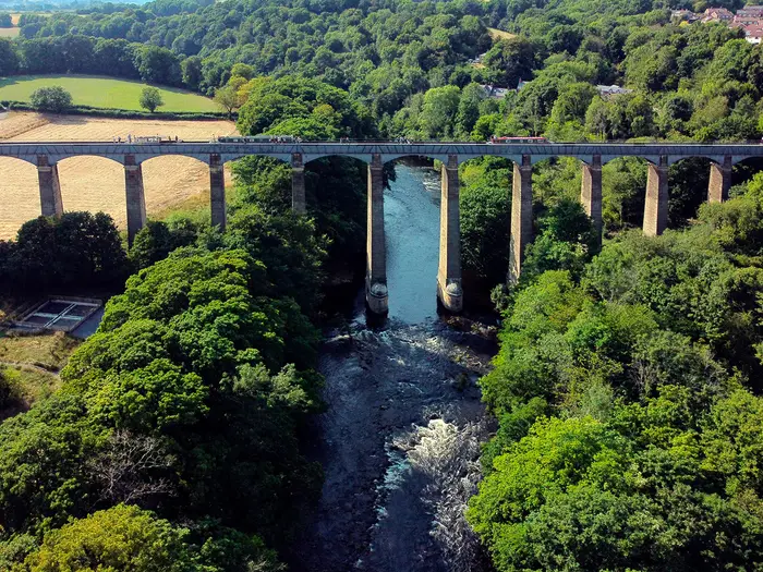
This is one of the most varied stages in the northern half of the walk, linking the Chirk area with the Vale of Llangollen, Trevor, the Llangollen Canal and the limestone scenery around the Eglwyseg crags. Llangollen itself is off route, but the area is an important accommodation and service base for many walkers.
The route includes canal-side walking, field paths, lanes and hillier ground as it approaches Llandegla. Paths around the limestone country can be rough or muddy in places, and the day has enough distance and variation to require steady pacing.
The headline landmark is Pontcysyllte Aqueduct near Trevor, Thomas Telford’s UNESCO World Heritage aqueduct carrying the Llangollen Canal high above the River Dee. It is one of the most distinctive built-heritage highlights on the whole trail.
Food and water should be planned around Chirk, Trevor, the Llangollen area and the end point, but current facilities and opening times should be checked before travelling. Accommodation may be found in the Llangollen area or at/near Llandegla, but if using an off-route overnight, the transfer or extra walking distance needs to be planned before the day starts.
Chirk is useful for public transport because of its station; transport from Llandegla is more dependent on regional links and should be checked before travelling. Navigation needs particular care where the canal, local paths and off-route options towards Llangollen create tempting alternatives to the National Trail line.
Stage 11: Llandegla to Bodfari — c.28 km
This is a long and exposed stage across the Clwydian Range, one of the defining landscapes of the northern trail. The route climbs into heather-clad hill country and crosses Moel Famau, around 555 m, with the ruined Jubilee Tower on its summit.
The terrain is upland path, grassy and heathery hill tracks, field paths and lanes on the approaches. There is no technical mountaineering, but the combination of distance, ascent, exposure and weather can make this one of the harder days late in the walk.
In clear conditions, the Clwydian Range gives some of the best views of the northern half of Offa’s Dyke Path, with a strong sense of nearing the coast. In mist, low cloud or winter conditions, the same open ground can become slow and navigationally serious.
Carry enough food and water for the full hill section, as services on the tops should not be expected. Bodfari is the official stage end, but accommodation can be limited compared with larger towns, so book ahead or arrange a transfer before committing to the day.
Public transport and road access at the end should be checked before travelling. Navigation on the Clwydian tops should not rely solely on waymarks in poor visibility; map, compass and/or reliable GPS are important, especially when tired after a long stage.
Stage 12: Bodfari to Prestatyn — c.19 km
The final stage completes the crossing of the northern hills before dropping to the coast at Prestatyn. It passes the Rhuallt area and then descends from Prestatyn Hillside to the Offa’s Dyke monument on the seafront beside Liverpool Bay / the Irish Sea.
Terrain remains mixed until the end: hill paths, field paths, lanes and the final descent into the town. After rain, grassy descents and enclosed paths can be slippery, so the shorter distance should not be treated as entirely effortless.
The key highlight is the transition from border hills to sea, with the finish monument marking the end of the 285 km National Trail. On a clear day, the approach to Prestatyn gives a strong sense of completion as the route drops out of the Clwydian landscape.
Carry normal day supplies from Bodfari, with Prestatyn providing the main end-of-walk services and accommodation options. Any intermediate facilities around Rhuallt should be checked before travelling rather than relied upon.
Prestatyn has a railway station on the North Wales Coast Line, making onward travel much simpler than from many mid-route points. Navigation is usually straightforward on the signed descent into town, but stay attentive through the urban approach so the final line to the seafront monument is not missed.
Recommended Itinerary
Standard 12-day itinerary
The cleanest way to plan Offa’s Dyke Path is to use the 12 official National Trail sections. This keeps the route close to the established stage structure, finishes most days at recognised trail hubs, and avoids relying on uncertain half-way accommodation in the more remote border hills.
| Day | From | To | Approx. distance | Why this stage makes sense | Services/accommodation notes |
|---|---|---|---|---|---|
| 1 | Sedbury Cliffs | Monmouth | 28 km | A full opening day from the Severn-side trailhead through the Wye Valley to a substantial market town. It gets the logistical awkwardness of the start out of the way and finishes somewhere practical. | Chepstow is the nearest rail-served town to the start. Monmouth has the best end-of-day services on this stage; book ahead in busy walking periods. |
| 2 | Monmouth | Pandy | 27 km | A long but logical approach to the Black Mountains, moving from lower border country to the foot of Hatterrall Ridge. | Pandy is a smaller overnight stop than Monmouth or Hay-on-Wye. Accommodation should be booked well ahead, and any transfer arrangements should be fixed before starting the walk. |
| 3 | Pandy | Hay-on-Wye | 28 km | This is the big mountain stage over Hatterrall Ridge, the highest ground on the trail at about 703 m. Keeping it as a single day avoids complex mid-ridge logistics, but it needs an early start in poor weather. | Hay-on-Wye is one of the most useful overnight towns on the route. Check the forecast carefully before leaving Pandy; the ridge is exposed and can be hard going in mist, low cloud or winter conditions. |
| 4 | Hay-on-Wye | Kington | 23 km | A more moderate day after the Black Mountains, continuing through rolling border country without the same high-level exposure. | Both Hay-on-Wye and Kington are established trail stops with accommodation. This is a sensible place to recover after the previous day rather than pushing on too far. |
| 5 | Kington | Knighton (Tref-y-Clawdd) | 22 km | A shorter official stage, but still hilly enough to deserve respect. Knighton is a natural mid-route base and one of the most useful places to pause, resupply or adjust plans. | Knighton (Tref-y-Clawdd) has a station on the Heart of Wales Line and is home to the Offa’s Dyke Centre. It is one of the better places on the route for a rest night. |
| 6 | Knighton (Tref-y-Clawdd) | Brompton Crossroads | 24 km | This stage enters the relentless switchback country of the Shropshire and Clun hills, widely treated as one of the toughest parts of the walk despite the modest distance. | Do not assume easy accommodation at the stage end. This is one of the sections where a pre-booked lift or off-route overnight may be needed; this should be checked before travelling. |
| 7 | Brompton Crossroads | Buttington Bridge | 20 km | A shorter day after the hardest hill country, with the route beginning to move towards the lower Severn valley. | Buttington Bridge is primarily a staging point rather than a guaranteed service hub. Plan the overnight carefully, especially if using Montgomery (Trefaldwyn) or a transfer. |
| 8 | Buttington Bridge | Llanymynech | 17 km | The shortest official day and a useful recovery stage, with easier ground than the upland sections before and after. | Llanymynech is a practical stage end only if accommodation is secured. Check availability before locking in the itinerary. |
| 9 | Llanymynech | Chirk Mill | 23 km | A balanced day that carries the route north towards Chirk (Y Waun) and the canal country before the more demanding northern hills. | Chirk (Y Waun) is near the route and has rail access, but the stage end is Chirk Mill. Check current transport times and the exact overnight arrangement before booking. |
| 10 | Chirk Mill | Llandegla | 26 km | A substantial northern stage passing the Llangollen Canal and the Pontcysyllte Aqueduct area before continuing towards Llandegla. | Llangollen is off route, so any overnight there needs an access plan. Llandegla accommodation should be booked ahead, as options are not as broad as in larger towns. |
| 11 | Llandegla | Bodfari | 28 km | A long and exposed penultimate day across the Clwydian Range, including the Moel Famau area. In bad weather this can feel much harder than the distance suggests. | Book Bodfari accommodation early. Carry full hill kit and do not treat this as an easy finish just because the coast is near. |
| 12 | Bodfari | Prestatyn | 19 km | A shorter final day over the last hills and down Prestatyn Hillside to the seafront finish, leaving a realistic chance of onward travel the same day. | Prestatyn has a station on the North Wales Coast Line. Allow enough time for the final descent, photos at the monument and the walk from the seafront to onward transport. |
Slower itinerary: 13–15 days
A slower schedule suits first-time long-distance walkers, anyone carrying heavier camping kit, and hikers who want more margin for bad weather on Hatterrall Ridge and the Clwydian Range. The simplest way to slow the route down is not to redesign every stage, but to add rest nights or split the longest days where accommodation or transfers allow.
Good places to add time include Hay-on-Wye after the Hatterrall Ridge crossing and Knighton (Tref-y-Clawdd) near the midpoint. Splitting the 28 km days — Sedbury Cliffs to Monmouth, Pandy to Hay-on-Wye, and Llandegla to Bodfari — can also make sense, but do not assume there will be a convenient half-way bed. Accommodation on remote upland and Shropshire-hill sections is limited; this should be checked before travelling.
Faster itinerary: 9–11 days
A faster schedule is only sensible for strong walkers who are used to repeated long days on hilly ground. The route is well waymarked, but the difficulty comes from cumulative ascent, steep border ups-and-downs and exposed weather rather than technical terrain.
The most obvious place to save time is around the shorter middle stages, especially where Buttington Bridge to Llanymynech is only 17 km and Brompton Crossroads to Buttington Bridge is 20 km. Combining official sections creates much longer days and can reduce accommodation flexibility, so faster itineraries should be built around confirmed overnight stops rather than an abstract target mileage. Check official mapping before booking any non-standard stage plan.
Planning the Route
How many days to allow
The standard plan is 12 walking days, matching the National Trail’s 12 official sections. That gives long but realistic days, generally between about 17 km and 29 km, and keeps the itinerary tied to the main overnight stops along the border.
Most walkers should allow around two weeks rather than trying to compress the route. The extra time is useful for travel at either end, a rest day, or a weather buffer before the exposed upland sections. Strong walkers can complete it faster, but the route is less about technical difficulty and more about repeated daily distance, steep climbs and cumulative fatigue.
A slower itinerary is usually more enjoyable if this is a first long-distance trail. The Wye Valley, Hatterrall Ridge, the Shropshire and Clun hills, the canal section near Llanymynech and the Clwydian Range all have a different feel, and rushing the walk removes much of the value of crossing them on foot.
Let the overnight stops shape the itinerary
Offa’s Dyke Path is not a trail where every stage can be freely adjusted by a few kilometres without consequence. Towns and larger villages provide the natural structure: Chepstow, Monmouth, Hay-on-Wye, Kington, Knighton (Tref-y-Clawdd), Montgomery (Trefaldwyn), Llanymynech, the Chirk (Y Waun) area, Llandegla, Bodfari and Prestatyn all matter when building the schedule.
Accommodation is thinner across the remote upland and Shropshire-hill sections, so those nights need booking first. In some places a short transfer off-route may be needed, especially where the official stage end is not a large service centre. Do not assume that every named stage end has multiple beds, evening meals or shops available on arrival.
The most important accommodation pinch points are likely to be around the higher and quieter middle sections, particularly between Pandy, Hay-on-Wye, Kington, Knighton (Tref-y-Clawdd), Brompton Crossroads, Montgomery (Trefaldwyn) and Buttington Bridge. Book these before committing to rail tickets or baggage-transfer arrangements.
Fast, slow or split stages?
The official 12-day schedule is a good framework, but it is not compulsory. If daily distances close to 28 km feel too demanding, plan extra nights and split the longer days where accommodation or transport makes that possible. This should be checked before travelling, as services vary considerably along the border.
Trying to walk the route quickly is most realistic for fit walkers who are comfortable with consecutive long days and who can carry enough food and water between settlements. The hard days are not only the mountain crossings: the switchback border country around Knighton (Tref-y-Clawdd) and the Shropshire and Clun hills can be as tiring as the higher ground.
A rest day is easiest to justify at a larger town with transport or services, such as Hay-on-Wye, Knighton (Tref-y-Clawdd) or another booked overnight base on the main line of the route. Rest days are also useful as weather buffers before Hatterrall Ridge or the Clwydian Range.
Section hiking
Section hiking is practical, but it needs more transport planning than a trail that follows one railway line. The route crosses the rail network at useful points rather than shadowing it throughout.
Chepstow is the practical rail access for the southern end, with the official start a short walk or taxi from Sedbury Cliffs. Prestatyn has a station at the northern end. Mid-route, Knighton (Tref-y-Clawdd) is on the Heart of Wales Line, and Chirk (Y Waun) is near the route; many other links depend on regional buses.
For section hiking, build each block around dependable access points first, then fit the walking days between them. Current train and bus times should be checked before travelling, especially for weekends, bank holidays and rural evening services.
Planning priorities
| Priority | What to plan |
|---|---|
| Accommodation | Book remote and upland-section nights early. Expect a mix of hotels, guesthouses, B&Bs, occasional hostels or bunkhouses and campsites, with fewer choices away from the main towns. |
| Food | Use the larger towns and villages for resupply, but carry enough food for the day before leaving each overnight stop. Do not rely on finding regular cafés or shops between settlements. Opening times should be checked before travelling. |
| Water | Carry adequate water for full-day stages, especially over exposed ridges and hill country. Availability on route should not be assumed between villages. |
| Navigation | The trail is waymarked with the National Trail acorn, but proper navigation is still needed. Hatterrall Ridge and the Clwydian Range have exposed, open ground where mist, low cloud or snow can make route-finding more serious. |
| Weather | Spring, summer and autumn are the main walking seasons. Winter is possible for well-equipped walkers, but the Black Mountains and Clwydian Range should be treated cautiously in poor visibility or snow. |
| Transport | Plan the start, finish and any rest-day exits separately. Chepstow and Prestatyn are the clearest railheads; mid-route public transport is patchier and often bus-based. |
| Diversions | Check the official National Trail information before departure for temporary closures, diversions or erosion-repair work, particularly on Severn-side and upland sections. |
| Permits and camping | The main issue is not a trail permit but where each night will be spent. Campsites, bunkhouses and any camping permissions should be checked and booked before travelling. |
Towns, Villages and Overnight Stops
Offa’s Dyke Path has enough towns and larger villages for a conventional inn/B&B-style walk, but the spacing is uneven. The Wye Valley, Hay-on-Wye, Kington, Knighton (Tref-y-Clawdd), Montgomery (Trefaldwyn), the Llangollen area and Prestatyn are the strongest overnight bases; the remote upland and Shropshire-hill sections need more careful booking.
Do not assume every stage end has a full spread of accommodation, evening meals and onward transport. On the thinner sections, it is common to use a nearby village, an off-route B&B, a taxi transfer or a pre-arranged lift from accommodation. This should be checked before travelling.
Sedbury Cliffs
Sedbury Cliffs is the official southern trailhead, marked by the Offa’s Dyke stone above the Severn estuary. It is not the practical overnight base for most walkers; nearby Chepstow is the usual place to stay before starting.
There should be no expectation of trailhead services at the cliffs themselves. Start-day logistics are best arranged around Chepstow, with enough time allowed to reach the monument and begin the first stage to Monmouth.
Chepstow
Chepstow is the practical gateway for the southern start, a short walk or taxi ride from Sedbury Cliffs. It is one of the easiest places on the route to organise a pre-walk night, last-minute food, maps and onward transport.
Accommodation is much stronger here than at the trailhead, with typical town options such as hotels, guesthouses and B&Bs. Chepstow has a railway station on the Gloucester–Newport line, making it the most straightforward access point for walkers starting in the south.
Brockweir
Brockweir lies early in the Wye Valley section between Sedbury Cliffs and Monmouth. It can be useful for breaking up the opening day if a shorter first stage is preferred, but the standard 12-section itinerary continues to Monmouth.
Facilities and accommodation should be treated as limited compared with Chepstow and Monmouth. If planning to stop here, book ahead and check food options before relying on them.
Tintern
Tintern sits across the valley from the trail in the Wye Valley, below the Devil’s Pulpit viewpoint area. It is not on the main line of the path but is close enough to matter for walkers looking at Wye Valley accommodation or a shorter first day.
Because it is off the direct route, any overnight here needs a clear plan for leaving and rejoining the trail. Food, accommodation and local transport arrangements should be checked before travelling.
Redbrook
Redbrook is on the Wye Valley approach to Monmouth and can work as a minor stopping or refreshment point depending on the day’s plan. It is more useful as a marker on the early route than as a default overnight stop.
Walkers should not rely on it as a full resupply base without checking current services. For most itineraries, Monmouth is the more practical overnight target.
Monmouth
Monmouth is the first major overnight stop on the official south-to-north itinerary, reached after the long opening stage from Sedbury Cliffs. It is a good place to recover from the first full day and reset before the next section to Pandy.
The town is one of the stronger service centres on the route, with a broader choice of accommodation than the smaller Wye Valley settlements. It is also a practical place for food and supplies before the trail leaves the Wye Valley for quieter border country.
The path enters Monmouth via the Monnow Bridge, one of the memorable town approaches on the trail. Book ahead in busy walking periods, especially if keeping to the official 12-stage schedule.
Llantilio Crossenny
Llantilio Crossenny sits on the Monmouth to Pandy section, where the route becomes more rural. It is best treated as a small-route settlement rather than a guaranteed service hub.
Accommodation and food options are likely to be far thinner than in Monmouth or Pandy. If using it to shorten the stage, arrange the overnight and evening meal before committing to the itinerary.
Pandy
Pandy is the official stage end before the crossing of Hatterrall Ridge in the Black Mountains. It is an important overnight stop because the next day is one of the highest and most exposed sections of the whole route.
Accommodation here needs booking ahead, as options are more limited than in the larger towns. Arrive with the next day’s mountain conditions in mind: food, water, waterproofs, warm layers and navigation should be sorted before leaving Pandy.
Transport options in this part of the route are less straightforward than at the start and finish. Any bus, taxi or accommodation transfer plans should be checked before travelling.
Llanthony
Llanthony lies in the valley below Hatterrall Ridge, rather than on the main ridge line of the National Trail. It is relevant for walkers considering an off-route valley overnight or a bad-weather escape from the high ground.
Do not treat Llanthony as an automatic stage end unless the detour and re-ascent are planned carefully. Accommodation, food and transport should be arranged in advance, particularly because the surrounding mountain section is exposed and can be difficult in mist.
Hay-on-Wye
Hay-on-Wye is the natural stop after the Hatterrall Ridge crossing and one of the most useful towns on the southern half of the trail. It is a strong candidate for an overnight, a slower morning or a rest stop after the Black Mountains.
The town has a better spread of accommodation than the upland settlements, including the kind of B&Bs, guesthouses and small hotels commonly used by National Trail walkers. It is also one of the better places to deal with food and general resupply before the route heads towards Kington.
Hay-on-Wye is famous for its bookshops and literary festival, but for walkers its main value is practical: beds, food and a chance to dry kit after the open ridge. Accommodation should still be booked ahead in popular periods.
Gladestry
Gladestry lies between Hay-on-Wye and Kington and can be useful for walkers adjusting the official stage length. It is not as strong a service base as either town at the ends of the section.
Any overnight here should be planned rather than improvised. Check accommodation, food availability and opening times before relying on it.
Kington
Kington is the official stage end between Hay-on-Wye and Knighton and is one of the more useful border towns for walkers. It works well as an overnight base before the route enters the hillier country towards Knighton.
Accommodation is generally more viable here than in the smaller villages on either side, but advance booking is still sensible. Kington is also a sensible resupply point before the tougher central part of the trail.
The following stage to Knighton is not the longest on the route, but it sits within more demanding border-hill terrain. Use Kington to prepare for a more committing run of days.
Knighton (Tref-y-Clawdd)
Knighton (Tref-y-Clawdd) is one of the key stops on Offa’s Dyke Path. It is the only town actually on the dyke, sits around the rough midpoint of the trail, and is home to the Offa’s Dyke Centre run by the Offa’s Dyke Association.
For logistics, it is one of the most important overnight bases on the route. Accommodation options are stronger than in the surrounding Shropshire and Clun hills, and it is a sensible place to regroup before the relentless ups and downs north of town.
Knighton has a station on the Heart of Wales Line, making it one of the few useful mid-route rail access points. Timetables and onward connections should be checked before travelling.
Brompton Crossroads
Brompton Crossroads is an official stage end on the 12-section itinerary, but it should be treated as a logistical point rather than a full town base. This is one of the sections where accommodation can be thin and walkers may need a transfer off-route.
Plan this night early, especially if walking in peak season or keeping to the official schedule. Do not arrive assuming there will be nearby beds, evening meals or shops available without prior arrangement.
This part of the route follows some of the toughest switchback border country, so a long transfer after arrival is best avoided if possible. If a transfer is needed, arrange it before setting out from Knighton.
Montgomery (Trefaldwyn)
Montgomery (Trefaldwyn) is a useful border-town stop after the high dyke country. It is not the official stage end in the 12-section itinerary, but it is an important accommodation option in this part of the route.
The town offers a better overnight prospect than many minor settlements nearby, and it can be used to reshape the itinerary around the Brompton Crossroads to Buttington Bridge section. Its position beneath the ruined castle also makes it one of the more attractive town stops, though the practical reason to stop is the relative availability of beds.
If using Montgomery instead of the official stage pattern, check how the detour or transfer affects the next day’s mileage. This should be checked before travelling.
Buttington
Buttington, and the nearby Buttington Bridge stage end, marks the transition towards the flatter Severn valley and the Montgomery Canal section. It is an official overnight point in the 12-section itinerary, but services should not be assumed to match those in larger towns.
Accommodation and food arrangements need checking ahead. Some walkers may prefer to use nearby alternatives or arrange a transfer depending on availability.
Llanymynech
Llanymynech is the official stage end after the shorter Buttington Bridge to Llanymynech section. It is a practical overnight target before the route continues north towards Chirk Mill.
As a larger village on the route, it is more useful than the smaller rural points, but accommodation and food should still be booked or checked before arrival. It is also a sensible place to review the next two days, which lead towards the canal, aqueduct and Llangollen area.
Trefonen
Trefonen lies between Llanymynech and Chirk and may be useful for walkers breaking the official stage. It should be treated as a smaller village stop rather than a guaranteed full-service base.
If planning to overnight here, check accommodation, food and onward transport in advance. Otherwise, Chirk Mill or the Chirk area is the more natural target on the standard itinerary.
Chirk (Y Waun)
Chirk (Y Waun) lies near the route and is one of the more useful logistical points in the northern half of the trail. The official stage end is Chirk Mill, with Chirk itself close enough to be relevant for accommodation, food and transport planning.
Chirk has a railway station near the route, making it one of the few practical mid-route rail access points. Timetables should be checked before travelling, especially if using it for a section start, section finish or rest-day connection.
This is also the area where the trail meets the Llangollen Canal landscape and the Pontcysyllte Aqueduct near Trevor. Accommodation should be booked ahead if aiming to stay close to the route rather than transferring into the wider Llangollen area.
Trevor
Trevor is important because of its position near the Pontcysyllte Aqueduct and Llangollen Canal. For many walkers, this is a highlight rather than a primary overnight base.
Facilities and accommodation should be checked before relying on Trevor as a stop. If the immediate area is full or inconvenient, the wider Chirk and Llangollen area may offer better options, but transfers or off-route walking need to be planned.
Llangollen
Llangollen is off the main line of Offa’s Dyke Path but is one of the most useful accommodation areas near the Chirk to Llandegla section. It can work well for walkers who want more choice than the smaller settlements directly on the route.
The trade-off is logistics. Staying in Llangollen may require a short transfer or extra off-route travel to leave and rejoin the National Trail, so the start and finish points for the day need to be fixed clearly.
The area is useful for beds, food and a more comfortable overnight before the route heads into the Clwydian side of the walk. Transport and transfer options should be checked before travelling.
Llandegla
Llandegla is the official stage end between Chirk Mill and Bodfari. It is a key overnight stop because the following day into the Clwydian Range is one of the longer official sections.
Accommodation is more limited than in larger towns, so book ahead and check evening food before arrival. This is not a place to leave the night’s arrangements vague, particularly if walking the official 12-day schedule.
Use Llandegla to prepare for the final upland section towards Bodfari and the approach to Moel Famau. In poor weather, the Clwydian Range can be exposed and navigation should not be taken lightly.
Bodfari
Bodfari is the final overnight stop on the official 12-section itinerary before Prestatyn. It is a practical staging point for the last day over the northern hills and down to the coast.
Accommodation should be booked ahead, as options are not comparable with Prestatyn. Check food arrangements in advance, especially if arriving late after the long stage from Llandegla.
The next day to Prestatyn is shorter than several earlier stages, but it still crosses hill country before the final descent. Do not treat it as a simple urban approach until the route has dropped off Prestatyn Hillside.
Rhuallt
Rhuallt lies on the final approach between Bodfari and Prestatyn. It can be useful as a route marker or possible break point, but it is not the normal final overnight target on the official itinerary.
Anyone planning to stop here should check accommodation, food and onward transport before travelling. Most walkers continue to Prestatyn to finish at the seafront monument.
Prestatyn
Prestatyn is the northern finish and the easiest place to end the walk cleanly. The path descends from Prestatyn Hillside to the Offa’s Dyke monument on the seafront, where the route reaches the Irish Sea / Liverpool Bay.
Accommodation is stronger here than in the smaller final-stage villages, making it a sensible place to book a finish-night stay rather than rushing for a late train. Prestatyn has its own station on the North Wales Coast Line, so onward travel is more straightforward than from most mid-route points.
If finishing on a tight schedule, check train times before committing to the final day’s plan. In poor weather, allow enough time for the hill section before the descent into town.
Getting to the Start
The southern trailhead is the Offa’s Dyke stone on Sedbury Cliffs, above the Severn estuary near Chepstow. Chepstow is the practical access point for most walkers; the official start is a short walk or taxi ride from the town, so allow time for this before the first full stage to Monmouth.
By train
Chepstow has a railway station on the Gloucester–Newport line, making it the main railhead for the southern start. For longer-distance journeys, plan rail travel to Chepstow via Gloucester or Newport, then continue to the station closest to the trailhead.
From Chepstow station, the official start at Sedbury Cliffs is not directly outside the station. Most walkers either walk out to the Offa’s Dyke stone or take a local taxi, particularly if starting late in the day or carrying a full pack. Current train times and any engineering works should be checked before travelling.
By bus
Bus options around Chepstow and Sedbury may be useful for local access, but the train is the more straightforward public transport option for most end-to-end walkers. Bus routes and frequencies can change, especially outside commuter times and at weekends, so this should be checked before travelling.
If arriving by bus, check carefully where the service stops in relation to both Chepstow town centre and Sedbury Cliffs. The official start is on the cliffs, not simply in Chepstow itself.
By car
Driving to the start is possible in practical terms, but Offa’s Dyke Path is a point-to-point trail ending at Prestatyn, so leaving a car near Chepstow creates a return-journey problem at the end of the walk. Long-stay parking arrangements in Chepstow or near Sedbury should be checked before travelling, and walkers should not assume convenient long-stay parking at the cliff-top trailhead.
A common approach is to travel to Chepstow by public transport and avoid moving a vehicle at the end of the hike. If using a car, plan the finish logistics at Prestatyn before committing to a parking location at the southern end.
From the nearest airport
Airport access is best planned around onward rail travel to Chepstow, using the Gloucester–Newport line for the final rail leg. The most convenient airport will depend on flight availability, arrival time and onward train connections, so this should be checked before travelling.
Build in enough time for delays and for the transfer from Chepstow to Sedbury Cliffs. Starting the first 28 km stage to Monmouth immediately after a flight is usually a poor plan unless arrival is very early and all connections are reliable.
Where to stay before starting
Chepstow is the obvious place to stay before beginning the trail. It has the best practical position for the southern trailhead and allows an early start for the first stage from Sedbury Cliffs to Monmouth.
Staying in Chepstow also makes it easier to buy last-minute food, sort baggage-transfer arrangements if using them, and take a taxi to Sedbury Cliffs if needed. Accommodation should be booked ahead in busy walking periods, and the exact access from your accommodation to the Offa’s Dyke stone should be checked before setting out.
Getting Home from the Finish
Offa’s Dyke Path finishes at the Offa’s Dyke monument on Prestatyn seafront, after descending from Prestatyn Hillside to the Irish Sea / Liverpool Bay. Prestatyn is one of the easier National Trail finishes to leave because the town has its own railway station on the North Wales Coast Line.
By train
Prestatyn railway station is the main exit point from the northern finish. The station is on the North Wales Coast Line, so most walkers should plan to leave the trail by train rather than arranging a long private transfer.
If returning to the southern start area, Chepstow also has a railway station on the Gloucester–Newport line, but the journey from Prestatyn will require onward rail connections. Exact routings, journey times and last trains should be checked before travelling, especially if finishing late in the day.
Do not assume there will be a convenient evening departure after a long final stage from Bodfari. If the final day is likely to run late, book a night in Prestatyn and travel the following morning with more time and less pressure.
By bus
Local and regional buses may be useful for short onward journeys from Prestatyn or for reaching accommodation away from the station, but the finish is primarily a rail-friendly endpoint. Bus routes, evening services and Sunday/public-holiday timetables are timetable-dependent and should be checked before travelling.
For walkers section-hiking the northern end, buses may also be relevant for linking back towards previous stage points such as Rhuallt or Bodfari, but services should not be treated as guaranteed without checking current times.
By car/taxi
If being collected by car, agree a clear meeting point in Prestatyn rather than on the hillside descent. The official finish is at the seafront monument, which is the natural place to complete the walk before moving on into town.
Taxis can be useful for short local transfers, late arrivals, or accommodation away from the station. Availability can be limited at busy times or late in the evening, so pre-booking is sensible if the onward plan depends on one.
Leaving a vehicle at the finish for the whole walk is possible only if secure long-stay parking arrangements have been made independently. Parking rules, costs and time limits in Prestatyn should be checked before travelling.
From the nearest airport
There is no airport at the trail finish, so the practical first step for onward flights is to take the train from Prestatyn and connect towards the airport city being used. The best airport will depend on flight choice, rail connections and the time of day, so this should be checked before travelling.
If flying the same day, allow a generous margin. A delayed finish on the Clwydian Range, a missed connection or reduced evening service can quickly make a tight flight plan unrealistic.
Where to stay at the finish
Prestatyn is a sensible place to stay at the end of the walk, particularly after the final stage from Bodfari. Staying overnight removes the need to rush the last hills and gives more reliable onward travel options the next morning.
Accommodation in Prestatyn includes the typical town mix of hotels, guesthouses and B&Bs. Book ahead in the main walking season, and be especially cautious with late-arrival check-in times if planning to walk the full final stage before reaching the coast.
Which Direction Should You Walk?
Offa’s Dyke Path is normally walked south to north, from Sedbury Cliffs near Chepstow to Prestatyn. That is the standard National Trail flow, and it is the direction used by the 12-stage itinerary on this guide.
Walking north to south is entirely possible. The trail is waymarked as a National Trail and there is no technical ground that makes one direction essential, but the two directions feel different in planning and psychology.
South to north: Sedbury Cliffs to Prestatyn
This is the best direction for most walkers. You start at the Offa’s Dyke stone above the Severn estuary, ease into the route through the Wye Valley, then hit the first major upland test on Hatterrall Ridge between Pandy and Hay-on-Wye.
The scenery also builds well. After the Wye, Black Mountains and mid-route border hills, the walk changes character through the Severn valley, Montgomery Canal area, Vale of Llangollen and finally the Clwydian Range before dropping to the Irish Sea at Prestatyn.
Transport is straightforward at both ends, but the standard direction has a particularly neat finish. Chepstow has a railway station a short walk or taxi from Sedbury Cliffs, while Prestatyn has its own station after the seafront finish, making the journey home relatively simple.
Accommodation planning is also easier this way because the official 12 sections run south to north: Monmouth, Pandy, Hay-on-Wye, Kington, Knighton (Tref-y-Clawdd), Brompton Crossroads, Buttington Bridge, Llanymynech, Chirk Mill, Llandegla, Bodfari and Prestatyn. Remote upland and Shropshire-hill nights still need booking well ahead, but the standard itinerary is the simplest framework to work from.
North to south: Prestatyn to Sedbury Cliffs
Walking southbound gives a more abrupt start. From Prestatyn the route climbs away from the coast into the Clwydian Range early, so the final hills of the northbound walk become an immediate test.
The reverse direction may suit walkers whose transport, accommodation or available dates line up better from north to south. It can also be a satisfying option for anyone wanting to finish above the Severn estuary at Sedbury Cliffs rather than by the sea at Prestatyn.
The main drawback is that planning will run against the standard stage descriptions used for the official south-to-north sections. Distances are the same, but daily logistics, accommodation transfers and mental pacing can feel less intuitive when reversing the usual flow.
Are the climbs easier one way?
There is no decisive climbing advantage. Offa’s Dyke Path is defined by repeated ascents and descents, especially through the Black Mountains, the Radnorshire and Shropshire hills, and the Clwydian Range.
The total ascent is the same whichever way you walk. Some climbs will feel steeper in one direction and some descents rougher in the other, but this is not a route where direction should be chosen mainly on gradient.
Weather and exposure
The exposed sections matter more than direction. Hatterrall Ridge and the Clwydian Range can be hard going in mist, low cloud, winter conditions or strong winds, whether walked northbound or southbound.
Do not choose direction on the assumption that the weather will be kinder one way. Check forecasts before the upland days, carry proper navigation, and be prepared to adjust plans if conditions are poor.
Recommendation
For most hikers, walk south to north: Sedbury Cliffs to Prestatyn. It follows the normal National Trail direction, matches the standard 12-section itinerary, gives a strong progression through the landscapes of the border, and finishes with the memorable descent from Prestatyn Hillside to the Irish Sea.
Walk north to south only if it suits your dates, transport or accommodation better. The trail works in either direction, but south to north is the clearest and most practical choice for a first full traverse.
Accommodation Along the Route
Offa’s Dyke Path works well as an inn-to-inn walk, but it is not a route where every official stage end has a large accommodation base. The easiest nights to organise are in the recognised trail towns: Chepstow, Monmouth, Hay-on-Wye, Kington, Knighton (Tref-y-Clawdd), Montgomery (Trefaldwyn), the Llangollen area and Prestatyn.
The awkward sections are the upland and hill-country stages, especially around the Black Mountains, the Shropshire and Clun hills, and some of the smaller border villages. In these areas, accommodation can be limited, spread out or off-route, so booking ahead matters more than on many lower-level National Trails.
Best overnight bases
For a standard 12-day itinerary, the main accommodation stops broadly follow the official National Trail sections: Monmouth, Pandy, Hay-on-Wye, Kington, Knighton (Tref-y-Clawdd), the Brompton Crossroads area, Buttington Bridge, Llanymynech, Chirk Mill / Chirk (Y Waun), Llandegla, Bodfari and Prestatyn. Not all of these are equal as overnight bases.
Monmouth, Hay-on-Wye, Kington, Knighton (Tref-y-Clawdd) and Prestatyn are the strongest practical stops because they are towns with a better chance of hotels, guesthouses, B&Bs and food options. Chepstow is also the sensible base for the night before starting at Sedbury Cliffs.
Pandy, Brompton Crossroads, Buttington Bridge, Llandegla and Bodfari need more care. These are the kinds of stops where a single closure, full B&B or minimum-stay rule can affect the whole itinerary, so arrange those nights before fixing the rest of the schedule.
Accommodation table
| Place | Accommodation level | Best for | Notes |
|---|---|---|---|
| Sedbury Cliffs | None | Official start only | The trailhead is on the cliffs above the Severn estuary. Use Chepstow for accommodation before starting. |
| Chepstow | Good | Pre-walk night, rail access, supplies | A practical base for the southern start, with the official trailhead a short walk or taxi away. |
| Brockweir | Limited | Breaking up the Wye Valley stage | Useful only if planning a shorter early stage. Availability should be checked before building an itinerary around it. |
| Tintern | Limited | Off-route Wye Valley option | Across the valley from the path and useful for some itineraries, but it is not one of the main official stage ends. |
| Redbrook | Limited | Short-stage planning near Monmouth | Better treated as a possible intermediate stop than a default overnight base. |
| Monmouth | Good | First main overnight stop, food and services | One of the stronger accommodation bases on the southern half of the trail. |
| Llantilio Crossenny | Limited | Breaking Monmouth–Pandy | Small-place logistics apply; accommodation and evening food should be checked before travelling. |
| Pandy | Limited | Base before Hatterrall Ridge | Important to book ahead because the next stage crosses the open Black Mountains to Hay-on-Wye. |
| Llanthony | Limited | Off-route valley option below Hatterrall Ridge | Useful for some walkers using transfers or a variant plan, but it sits below the ridge rather than directly on the main stage line. |
| Hay-on-Wye | Good | Rest stop, food, accommodation choice | A natural recovery point after the Black Mountains. It can be busy during festival periods, so check dates and book early. |
| Gladestry | Limited | Short-stage option before Kington | Useful if reducing daily distance, but should not be assumed to have spare beds. |
| Kington | Good | Main overnight stop before the Knighton stage | A practical town stop with better accommodation prospects than the smaller settlements around it. |
| Knighton (Tref-y-Clawdd) | Good | Mid-route stop, rest day, Offa’s Dyke Centre | One of the key places to secure early, especially if walking during busy spring, summer or autumn periods. |
| Brompton Crossroads | Limited | Official stage end after the Shropshire and Clun hills | This is one of the more awkward planning points. A nearby stay or short transfer off-route may be needed. |
| Montgomery (Trefaldwyn) | Good | Alternative stop near the central sections | A useful accommodation base beneath the ruined castle, though not the official end of every 12-day schedule. |
| Buttington Bridge | Limited | Official stage end before Llanymynech | Treat as a logistics point rather than a major accommodation hub. Check nearby options and transfers before committing. |
| Llanymynech | Limited | Overnight between Buttington and Chirk Mill | A workable stage stop, but book ahead rather than relying on late availability. |
| Trefonen | Limited | Short-stage option before Chirk | Useful only for customised itineraries. This should be checked before travelling. |
| Chirk (Y Waun) / Chirk Mill | Limited | Overnight near the canal and aqueduct section | Chirk is near the route and has transport value, but accommodation should still be arranged in advance. |
| Trevor | Limited | Canal and Pontcysyllte Aqueduct area | Can help with a shorter stage or access to the Llangollen area. Availability should be checked before travelling. |
| Llangollen | Good | Off-route accommodation base, rest stop | A strong option in the wider area, but it is off the main line of the trail, so factor in the transfer or extra walking. |
| Llandegla | Limited | Base before the Clwydian Range | Important to secure early because the following stages cross exposed final hill country. |
| Bodfari | Limited | Final overnight before Prestatyn | A key booking on the northern end of the trail. Do not leave this night to chance. |
| Rhuallt | Limited | Short final-stage option | Useful only for walkers splitting the Bodfari–Prestatyn section. Check availability before planning around it. |
| Prestatyn | Good | Finish, post-walk night, rail access | The most convenient northern finish base, with its own station on the North Wales Coast Line. |
Booking strategy
Book the constrained nights first: Pandy, Brompton Crossroads, Buttington Bridge, Llanymynech, Llandegla and Bodfari. Once those are fixed, the larger-town nights are easier to fit around them.
For a two-week schedule, consider adding a rest or shorter day in places with stronger services, such as Hay-on-Wye, Knighton (Tref-y-Clawdd), Montgomery (Trefaldwyn), the Llangollen area or Prestatyn after finishing. Rest days are much harder to organise comfortably in the smaller hill-country stops.
Spring, summer and autumn are the main walking seasons, so popular weekends can fill well ahead. Hay-on-Wye also needs particular care around literary festival periods. Confirm current availability, meal arrangements and check-in times before booking non-refundable rooms.
Transfers, luggage and awkward gaps
Short taxi transfers can make the accommodation pattern much easier, especially around the remote upland and Shropshire-hill sections. This is often the practical solution where the official stage end has limited beds or where a walker wants to stay in a larger nearby town.
Luggage transfer can also make the route more comfortable for inn-to-inn walkers, particularly because the trail has sustained day-after-day ascent and descent rather than one isolated hard day. Arrange baggage movement around the booked accommodation list, not the other way round.
If using transfers, keep the plan simple: agree pickup points, timings and phone signal expectations before setting out each morning. On exposed sections such as Hatterrall Ridge and the Clwydian Range, do not rely on being able to rearrange logistics from the hill in poor weather.
Camping and Wild Camping
Camping is possible on Offa’s Dyke Path, but it needs more planning than a simple campsite-to-campsite trail. The route has campsites among the accommodation options in and around the larger towns and villages, including places such as Chepstow, Monmouth, Hay-on-Wye, Kington, Knighton (Tref-y-Clawdd), Montgomery (Trefaldwyn), the Llangollen area and Prestatyn.
Away from those hubs, accommodation is thinner, especially on the remote upland and Shropshire-hill sections. Campers should not assume there will be a formal site at the end of every official stage; some nights may require a shorter or longer day, a short transfer off-route, or a non-camping night indoors. Current campsite opening dates, facilities and booking requirements should be checked before travelling.
Does the route suit camping?
Offa’s Dyke Path can suit experienced long-distance campers who are comfortable carrying extra weight over repeated steep climbs. The path is not technical, but 285 km of border country with more than 8,000 m of ascent becomes harder with a full camping pack.
The toughest camping days are likely to be the exposed upland and hill sections: Hatterrall Ridge between Pandy and Hay-on-Wye, the switchback country around Knighton and the Shropshire/Clun hills, and the Clwydian Range before Prestatyn. These are not places to be under-equipped in wind, mist, low cloud or winter conditions.
For many walkers, the most practical approach is mixed accommodation: camp where a formal site works well, then use a B&B, guesthouse, hostel or bunkhouse where the stage is remote or the weather is poor.
Wild camping and permission
Do not treat Offa’s Dyke Path as a route where wild camping is automatically allowed. The trail crosses a patchwork of farmland, woodland, lanes, upland, National Trail corridor and protected landscapes, and much of the land is privately owned or managed.
Wild camping should be treated as permission-only unless local access rules clearly allow otherwise. If permission cannot be obtained, use a formal campsite or booked accommodation instead. This should be checked locally before relying on any wild-camping plan.
Never pitch on Offa’s Dyke itself or on eroded banks, earthworks, field boundaries or archaeological features. The dyke is the defining historic feature of the trail, and camping on or beside it increases wear on already vulnerable sections.
Where camping logistics are easiest and hardest
| Part of the route | Camping considerations |
|---|---|
| Sedbury Cliffs / Chepstow to Monmouth | The Wye Valley section has settlements and services, but woodland and riverside ground should not be used for informal camping without permission. Formal sites or booked accommodation are the practical options. |
| Monmouth to Pandy to Hay-on-Wye | Plan the Hatterrall Ridge crossing carefully. It is open mountain ground with exposure, limited shelter and no reliable overnight facilities on the ridge itself. |
| Hay-on-Wye to Kington to Knighton (Tref-y-Clawdd) | These towns make better resupply and overnight anchors than the intervening countryside. Arrange camping or accommodation in advance rather than hoping to find a pitch late in the day. |
| Knighton to Brompton Crossroads to Buttington Bridge | This is one of the more awkward stretches for accommodation planning, with remote hill country and fewer obvious services. A formal campsite, off-route transfer or indoor night may be needed. |
| Buttington Bridge to Llanymynech to Chirk (Y Waun) / Trevor | The lower Severn valley, Montgomery Canal and settlement sections can be easier logistically, but canal towpaths and field margins should not be treated as free camping ground. |
| Chirk / Trevor to Llandegla to Bodfari to Prestatyn | The final hills of the Clwydian Range are exposed. Plan overnight stops either side of the high ground and avoid committing to a ridge camp in poor weather. |
Water and resupply for campers
Do not rely on streams, rivers, canal water or upland trickles as primary drinking-water sources. The route passes the River Wye, the Severn valley and the Montgomery Canal, but that does not mean water is safe or convenient for drinking.
The safest plan is to fill bottles at booked campsites, accommodation, cafés, pubs or other legitimate facilities in trail towns and villages. Carry enough water for exposed sections such as Hatterrall Ridge, the Shropshire and Clun hills, and the Clwydian Range, where services are sparse and weather can slow progress.
If using any untreated natural water in an emergency, it should be properly treated. Availability and quality vary, particularly after rain and through farmland.
Low-impact camping rules
Where camping is permitted, keep the pitch small, discreet and short-lived. Arrive late, leave early, and avoid blocking paths, gates, access tracks, livestock routes or farm operations.
Use a stove only where it is safe and permitted. Open fires are inappropriate on this route, especially in woodland, grassland, heather and upland areas, and can cause serious damage during dry spells.
Pack out all litter, food waste and used toilet paper. Use proper toilets whenever available; if none are available, camp and toilet well away from watercourses, buildings, livestock, paths and the dyke itself.
Seasonal points
Many campsites in the UK operate seasonally or reduce facilities outside the main walking season. Spring, summer and autumn are the normal camping seasons for this trail; winter camping adds cold, short daylight, mud and a much smaller margin for error.
The Black Mountains and Clwydian Range should be treated seriously in mist, low cloud, snow or strong wind. If the forecast is poor, a lower-level overnight stop or booked indoor accommodation is the safer plan.
Food, Water and Resupply
Resupply strategy
Offa's Dyke Path is not a wilderness route, but it is not a trail where food can be bought casually every few hours. The reliable approach is to use the larger towns as main resupply points: Chepstow, Monmouth, Hay-on-Wye, Kington, Knighton (Tref-y-Clawdd), Montgomery (Trefaldwyn), the Chirk (Y Waun) / Llangollen area and Prestatyn.
Between those hubs, many places are small villages, crossroads or off-route settlements. Pubs, cafés, village shops and petrol-station food may be useful where available, but rural opening hours can be short, seasonal and irregular. This should be checked before travelling, especially for Sundays, bank holidays and evenings.
Most walkers should start each day with lunch, high-energy snacks and an emergency spare meal or substantial backup food. This matters most on Hatterrall Ridge, the Shropshire and Clun hills, and the Clwydian Range, where the path spends long periods away from dependable services.
Even when staying in B&Bs or guesthouses, do not assume an evening meal is available on site or nearby. In thinner accommodation areas, ask when booking whether dinner, packed lunches or transfers to food are possible.
Water planning
Plan to fill bottles at accommodation, cafés, pubs or other mains-water points before leaving each settlement. On a typical UK walking day, carrying around 1.5–2 litres is sensible; in hot weather, on exposed ridges, or where the next refill is uncertain, carry more.
Natural water should not be treated as a dependable supply. The route crosses farmland, open hill, river valleys and canal country, but streams, rivers and troughs may be affected by livestock, agriculture or access issues. If natural water is used, it should be filtered or treated.
The most important water carries are the open upland and ridge stages: Pandy to Hay-on-Wye over Hatterrall Ridge, Knighton (Tref-y-Clawdd) to Brompton Crossroads through the switchback border hills, and Llandegla to Bodfari across the Clwydian Range. Start those stages full.
Stage-by-stage food and water notes
| Section | Food availability | Water availability | Notes |
|---|---|---|---|
| Sedbury Cliffs to Monmouth | Good at Chepstow and Monmouth. Smaller Wye Valley settlements such as Brockweir, Tintern across the valley and Redbrook may have options, but this should be checked before travelling. | Fill before leaving Chepstow / Sedbury area and again at Monmouth. Do not rely on the River Wye as drinking water. | Carry lunch unless a specific café or pub stop has been checked. |
| Monmouth to Pandy | Good at Monmouth. Pandy is a small end point, so evening food and next-day supplies should be arranged in advance. | Fill at Monmouth and at accommodation or services in Pandy if available. | Carry a full day's food and enough water for a rural stage. |
| Pandy to Hay-on-Wye | Very limited once on Hatterrall Ridge. Hay-on-Wye is the main resupply point at the end of the stage. | Start with full bottles. Water on the open ridge should not be relied on. | This is one of the key food-and-water carry days. Pack lunch, snacks and a reserve. |
| Hay-on-Wye to Kington | Good at Hay-on-Wye and Kington. Gladestry may offer limited options, but this should be checked before travelling. | Fill at Hay-on-Wye and refill at Kington. Intermediate refill opportunities are uncertain. | A normal packed-lunch day, with town resupply at both ends. |
| Kington to Knighton (Tref-y-Clawdd) | Good at Kington and Knighton. Limited dependable food between them. | Fill at Kington and Knighton. Treat rural water sources if used. | Carry lunch and snacks; do not assume a midday shop or pub will be open. |
| Knighton (Tref-y-Clawdd) to Brompton Crossroads | Good at Knighton before leaving. Brompton Crossroads is not a major resupply hub, so food at or near the finish must be pre-arranged. | Start full from Knighton. Refill options through the Shropshire and Clun hills are uncertain. | One of the more remote-feeling sections. Carry all food needed for the day plus a backup meal if accommodation arrangements are not clear. |
| Brompton Crossroads to Buttington Bridge | Food at the start and finish should not be assumed. Montgomery (Trefaldwyn) is the key place to plan around, but opening times should be checked. | Fill wherever staying near Brompton Crossroads. Refill options should be checked around Montgomery and Buttington. | This is a stage where accommodation, dinner and breakfast logistics need tying down before arrival. |
| Buttington Bridge to Llanymynech | Limited at Buttington Bridge. Llanymynech is the main end-of-day resupply point. | Fill before leaving Buttington Bridge area. The Severn valley and Montgomery Canal are not drinking-water sources without treatment. | Shorter than many stages, but still carry lunch unless a specific stop has been checked. |
| Llanymynech to Chirk Mill | Llanymynech and the Chirk (Y Waun) area are the main places to plan food around. Trefonen may have limited options; check current hours. | Fill at Llanymynech and again near the end of the stage. Treat any natural water. | Useful stage to restock before the Llangollen and Clwydian hills section. |
| Chirk Mill to Llandegla | Food is best planned around Chirk (Y Waun), Trevor and the Llangollen area, though Llangollen is off route. Llandegla options should be checked before relying on them. | Fill before leaving the Chirk / Trevor area. Refill at Llandegla if staying there, but check arrangements. | If diverting to Llangollen for food, allow time and distance for the off-route movement. |
| Llandegla to Bodfari | Limited dependable food once on the Clwydian Range. Bodfari is a small end point, so dinner and breakfast arrangements should be made in advance. | Start with full bottles. Upland water on the Clwydian Range should not be relied on. | Another key carry day: pack lunch, snacks and enough water for exposed hill walking. |
| Bodfari to Prestatyn | Limited early on. Prestatyn has the best end-of-trail resupply and food options. | Fill at Bodfari before leaving. Refill opportunities before Prestatyn should not be assumed. | A shorter final day, but still carry water and food until reaching town services. |
Terrain, Conditions and Difficulty in Practice
Offa's Dyke Path is a moderate National Trail in technical terms, but it is not an easy stroll. The walking is rarely difficult underfoot and there is no technical mountain ground, yet the route asks for repeated long days, frequent climbs and descents, and good judgement on exposed upland sections.
The total ascent is substantial, at roughly 8,534 m over the full trail, and ascent figures vary between mapping sources. In practice, the effort comes less from any single climb and more from the cumulative border-country pattern: down to a valley, up over a ridge, repeat the next day.
Surfaces underfoot
Expect a constantly changing mix of dirt, grass, gravel tracks, field paths, lanes, canal towpath and open moorland. This variety is one of the strengths of the trail, but it also makes daily pacing uneven: a flat canal section can pass quickly, while a similar distance through wet fields or hill country can take much longer.
After rain, the grassy and field-path sections can be muddy, especially where the path crosses working lowland farmland or climbs through softer upland ground. Waterproof footwear is sensible outside settled summer weather, and poles can be useful on steep grassy descents.
There is some lane walking. These sections are generally straightforward for navigation and speed, but they are hard underfoot over a long day and can feel tiring late in the route. Do not plan mileage purely from distance; surface and ascent matter more than the map line suggests.
The main terrain zones
| Route section | Terrain character | Practical difficulty |
|---|---|---|
| Sedbury Cliffs to Monmouth | Severn-side start, Wye Valley woodland, riverside meadow and high wooded viewpoints | Mixed surfaces and early climbing; can be slippery in woodland after rain |
| Monmouth to Pandy | Lowland farmland and border-country lanes/paths | Generally non-technical, but field paths can be slow when wet |
| Pandy to Hay-on-Wye | Hatterrall Ridge in the Black Mountains, reaching about 703 m | The most mountainous section; exposed, open and serious in poor visibility |
| Hay-on-Wye to Knighton (Tref-y-Clawdd) | Rolling border hills around Gladestry, Kington and Knighton | Sustained climbs and descents; tiring rather than technical |
| Knighton to Brompton Crossroads | Shropshire and Clun hills | Widely the most relentless switchback walking on the trail |
| Brompton Crossroads to Llanymynech | High dyke country easing towards the Severn valley and Montgomery Canal | Easier gradients in places, with faster going on flatter sections |
| Llanymynech to Llandegla | Mixed border walking, canal corridor, Vale of Llangollen and limestone Eglwyseg crags | Varied terrain; no technical climbing, but still a full walking day |
| Llandegla to Prestatyn | Clwydian Range, including Moel Famau, then descent towards the coast | Exposed heather tops; poor weather can make navigation and pacing harder |
Exposed upland sections
Hatterrall Ridge between Pandy and Hay-on-Wye is the highest and most mountainous part of the route. It is open ridge walking on the eastern edge of the Black Mountains, with few shelter options once committed to the high ground.
The Clwydian Range near the end of the trail is lower than Hatterrall Ridge but still exposed. The approach over heather tops, including Moel Famau, can feel much harder in wind, mist or persistent rain than it appears from the headline altitude.
Both areas need proper hillwalking kit, not just fair-weather walking clothes. In mist, low cloud or snow, navigation becomes more serious; winter crossings of these sections should be treated cautiously and avoided in poor conditions.
Climbs, descents and daily fatigue
The route's difficulty is cumulative. A fit walker may find any individual climb manageable, but the repeated steep ups and downs over 12 long sections create fatigue in knees, calves and feet.
The Shropshire and Clun hills between Knighton and Brompton Crossroads are especially demanding because the gradients come one after another. This is the part of the trail where conservative pacing pays off: save energy early in the day and avoid assuming that a modest distance will be quick.
The flatter Severn valley and Montgomery Canal sections provide useful relief, but they do not make the route easy overall. Long towpath or lane sections can still be tiring because of repetition and hard surfaces.
Farmland, gates and field conditions
Large parts of the trail pass through lowland farmland and field paths. Progress can be slower here than expected, particularly when grass is wet, field edges are muddy, or the route changes direction frequently across enclosed land.
Expect normal countryside access features such as field boundaries, gates and signed waymarks, and allow time for stop-start navigation through farmland. The National Trail acorn waymarking is a major help, but it does not remove the need for a map, guidebook or reliable GPS line.
Navigation and waymarking
Offa's Dyke Path is well waymarked as a National Trail, and the acorn symbols make most lowland and village sections straightforward. Navigation becomes more important where visibility is poor, especially on Hatterrall Ridge and in the Clwydian Range.
The path also follows or runs beside sections of the ancient Offa's Dyke earthwork for over 60 miles. Stay on the signed line, particularly where erosion or restoration work affects the route; current diversions and repair closures should be checked before travelling.
Seasonal conditions
Spring, summer and autumn are the normal walking seasons. Spring and autumn can bring cooler, wetter ground and shorter daylight, while summer gives the longest days but can still produce exposed, uncomfortable weather on the ridges.
Winter walking is possible, but the Black Mountains and Clwydian Range should be treated as proper hill country. Mist, low cloud, snow or strong wind can turn otherwise moderate walking into a navigation and safety problem.
After prolonged rain, expect slower going on grass, field paths and moorland. In dry settled weather, the same sections become much easier, but the long daily distances and repeated ascent still make fitness and foot care central to success.
Weather and Best Time to Walk
Offa’s Dyke Path is best treated as a spring-to-autumn walk. The route is not technically difficult, but it crosses exposed upland on Hatterrall Ridge in the Black Mountains and again in the Clwydian Range, where mist, wind, low cloud or snow can turn a straightforward waymarked path into a serious navigation day.
Best season
The most practical walking window is spring, summer and early autumn, when there is more daylight for the long 17–29 km official stages and a better chance of completing the upland days without winter conditions. Summer gives the longest days, which helps on the longer stages such as Sedbury Cliffs to Monmouth, Pandy to Hay-on-Wye, and Llandegla to Bodfari.
Spring and autumn can be excellent for fit walkers who prefer cooler conditions, but the route can be muddy after rain. Woodland and riverside sections in the Wye Valley, field paths, grassy banks beside the dyke and moorland tracks can all become slower underfoot when wet.
Winter realism
The path is walkable in winter, but it is not the best season for most end-to-end walkers. The Black Mountains and Clwydian Range have exposed ground and few landmarks in poor visibility, and the brief daylight leaves little margin on long stages if the going is muddy or navigation slows.
Winter attempts should be planned conservatively, with shorter days where possible, full waterproofs, warm layers, map-and-compass navigation and a willingness to stop or divert if the hill sections are in mist, low cloud, snow or strong wind. Hatterrall Ridge between Pandy and Hay-on-Wye is the key weather-sensitive stage; the Clwydian hills before Prestatyn also deserve the same caution.
Weather hazards by terrain
| Terrain / section | What matters in poor weather | Practical approach |
|---|---|---|
| Wye Valley and wooded/riverside paths | Mud, slippery woodland paths and slower progress after rain | Allow time early in the walk and do not judge daily pace from road sections alone |
| Hatterrall Ridge, Black Mountains | Exposure, wind, mist, low cloud and possible snow in winter | Carry proper hill kit and navigation; avoid committing to the ridge in poor visibility if not equipped |
| Radnorshire, Shropshire and Clun hills | Repeated steep ups and downs become tiring in wet or windy conditions | Keep food, water and waterproofs accessible; expect slower progress than the map distance suggests |
| Severn valley and Montgomery Canal towpath | Less exposed, but paths can still be wet and slow after prolonged rain | Useful mental respite after hillier days, but do not rely on completely dry surfaces |
| Clwydian Range and Moel Famau | Exposed heather tops, wind, mist and poor visibility | Treat as a hill day, not just the final approach to the coast |
Daylight and stage planning
The official 12-section itinerary includes several long days close to or above 25 km. In summer that is manageable for a fit walker with an early start; in winter or poor autumn weather, the same distance can become tight, especially on the upland and switchback sections.
If walking outside the main season, build in shorter stages where accommodation and transport allow. This is particularly important around the remote upland and Shropshire-hill sections, where accommodation is thinner and some nights may require a transfer off-route.
Accommodation and seasonal practicalities
Accommodation in the main towns and larger villages is mixed, but the remote sections need early booking at any time of year. In the main walking season, popular overnight stops such as Monmouth, Hay-on-Wye, Kington, Knighton (Tref-y-Clawdd), the Llangollen area and Prestatyn can book up, especially if walking fixed stages.
Campsites, hostels, bunkhouses and some smaller rural services may have seasonal opening patterns. This should be checked before travelling, particularly if relying on camping or on a specific off-route pickup.
Rain, mud and footwear
This is a border-country walk rather than a paved route. Expect a mix of dirt, grass, gravel, field paths, lanes, towpath and open moorland, with muddy going after rain.
Waterproof footwear with a reliable sole is the safest default. Lightweight shoes may be comfortable in dry summer conditions, but wet grass, churned field edges and steep muddy descents can make grip more important than speed.
Insects and ticks
The route crosses woodland, farmland, long grass and heather moorland, so normal UK tick precautions are sensible in the warmer months. Check legs and socks after grassy or heather sections, and carry a tick remover if walking in shorts or low socks.
Biting insects are not usually the defining issue on this trail, but they can be annoying around damp, sheltered ground in warm weather. A small repellent is worthwhile if camping or walking in still conditions.
Safety Notes
Offa's Dyke Path is a well-waymarked National Trail with no technical scrambling, but it is still a committing long-distance walk. The main safety issues are weather exposure, fatigue, navigation in poor visibility, road sections, livestock and the long gaps between services on some upland and hill stages.
Emergency help and mobile signal
In an emergency in the UK, call 999 or 112 and ask for Police, then Mountain Rescue if the incident is on open hill or remote ground. Give a clear location using a grid reference, What3Words if available, or the nearest named place, road, farm, summit, pass or National Trail waymark.
Mobile signal should not be relied on throughout the route. The Wye Valley, Hatterrall Ridge, the Radnorshire and Shropshire hills, and parts of the Clwydian Range can all leave walkers with limited or inconsistent coverage. Carry offline mapping, a charged phone, a power bank and a paper map or guidebook backup.
Solo walkers should leave a simple route plan with someone reliable, especially before the longer hill days. Agree a check-in time and make it clear what to do if no message arrives.
Weather and exposed ground
The most serious weather exposure is on Hatterrall Ridge between Pandy and Hay-on-Wye and on the Clwydian Range, including the final hill stages towards Prestatyn. These sections have open ground, few landmarks in poor visibility and can feel very different in mist, low cloud, strong wind, heavy rain or winter conditions.
The route is walkable outside summer, but the Black Mountains and Clwydian Range are best avoided in mist, low cloud or snow unless properly equipped and confident with navigation. A forecast that looks acceptable in a valley town can still mean cold wind and poor visibility on the tops.
Carry waterproofs, warm layers and gloves even in mild seasons. In hot weather, the exposed ridges and field paths can be draining, so start early, carry enough water and avoid assuming that shade or services will appear when needed.
Navigation and daily checks
The trail is waymarked with the National Trail acorn, but waymarks are not a substitute for navigation. Field edges, lanes, moorland paths and forestry or farmland junctions can still be confusing, particularly in bad weather or at the end of a long day.
Before setting off each morning, check:
- the weather forecast for both valleys and higher ground;
- daylight hours and whether the planned stage is realistic;
- the official trail information for diversions, erosion repairs or closures;
- the location of the next food, water and accommodation stop;
- bus or taxi options if the stage needs to be shortened;
- phone battery, offline maps and power bank;
- whether the day includes exposed ground such as Hatterrall Ridge, the Shropshire hills or the Clwydian Range.
Road walking and lanes
The route includes lanes and road crossings as it links villages, farms and hill sections. Use the usual UK road-walking precautions: face oncoming traffic where safe, step onto verges early, avoid wearing headphones on narrow lanes and be particularly careful near bends, brows and in poor visibility.
High-visibility clothing or a bright pack cover is useful in rain, mist or evening light. If a booked stage runs late, do not assume lane walking after dark will be straightforward.
Livestock and farmland
Much of the trail crosses working farmland. Keep to the signed right of way, close gates behind you, avoid blocking gateways and give livestock plenty of space.
Cattle, sheep and horses should be passed calmly and without sudden movement. Dogs should be kept under close control and on a lead where required, especially around livestock; if cattle become threatening, let the dog go rather than trying to hold it close.
Water, rivers, canals and steep edges
The route passes riverside ground in the Wye Valley, the Severn estuary at the southern end, canal towpaths around the Montgomery and Llangollen canals, and the Pontcysyllte Aqueduct area near Trevor. Take extra care on wet grass, muddy banks, towpaths and high or exposed waterside structures, especially in wind or when tired.
Do not descend unstable riverbanks to collect water or take shortcuts. Drinking water should be planned around towns, villages, accommodation and known services rather than assumed from streams or rivers.
Fatigue and long stages
The path’s difficulty is cumulative. A single day may feel moderate, but repeated 17–29 km stages with steep border ups-and-downs can quickly lead to tired decisions, slips and late finishes.
The switchback country around Knighton (Tref-y-Clawdd), the Clun and Shropshire hills, and the longer upland days deserve conservative pacing. If conditions are poor or a walker is carrying an injury, shortening a day or using an off-route transfer is safer than pushing on into darkness.
Gear Recommendations
Offa’s Dyke Path does not need technical mountain equipment, but it does demand reliable long-distance walking kit. The main gear challenge is not one extreme day; it is repeated 17–29 km stages over wet fields, lanes, wooded paths, exposed ridges and steep border-country climbs.
Footwear
Choose footwear for mixed ground rather than pure mountain terrain. The route uses dirt, grass, gravel paths, field paths, lanes, canal towpath and moorland, so grip on wet grass and mud matters as much as cushioning for hard surfaces.
Waterproof walking shoes or lightweight boots suit most walkers. Trail shoes can work well in dry conditions for experienced hikers, but the open sections, muddy field paths and repeated steep descents make good tread essential. Gaiters are useful after rain, especially through long grass, field edges and the muddier upland approaches.
Whatever is chosen, it should already be broken in. Blisters are a more likely trip-ending problem on this trail than any single technical obstacle.
Waterproofs and warm layers
Carry proper waterproof jacket and trousers throughout the walk, even in summer. Hatterrall Ridge in the Black Mountains and the Clwydian Range are exposed, and conditions can change quickly when cloud, wind or rain moves over the high ground.
A warm mid-layer is needed for stops on the ridges and for cooler evenings in upland villages. In spring and autumn, add hat and gloves; in winter conditions, the Black Mountains and Clwydian Range should be treated as serious hill days and avoided in mist, low cloud or snow unless equipped and competent for those conditions.
Navigation
The path is a waymarked National Trail, signed with the acorn symbol, but navigation should not rely on waymarks alone. Open sections such as Hatterrall Ridge and the Clwydian tops can be awkward in mist, and field-path navigation can become slow where signs are missed or vegetation obscures exits.
Carry offline mapping on a phone or GPS, plus a paper map or dedicated guidebook as backup. OS mapping for the route spans several sheets, so many walkers use a National Trail guide or route-specific map booklet rather than carrying full individual sheets for the whole border.
A compass is worth carrying for the open upland days. It is light, simple insurance when cloud drops onto the ridge.
Water and food carry
Do not assume regular refills on the more remote days. Towns and larger villages appear throughout the route, but the upland and Shropshire-hill sections have long stretches where services are limited.
Carry enough water for the whole day between planned stops, with extra capacity in warm weather. This is particularly important on exposed stages such as Pandy to Hay-on-Wye over Hatterrall Ridge, Knighton (Tref-y-Clawdd) to Brompton Crossroads, and Llandegla to Bodfari across the Clwydian Range.
Pack lunch and high-energy snacks before leaving each overnight stop if the next stage crosses quieter country. The flatter canal and valley sections are less committing, but even there cafés, shops and pub opening hours should not be treated as guaranteed. This should be checked before travelling.
Trekking poles
Trekking poles are strongly recommended for walkers carrying a full pack. They help on the repeated steep ups and downs through the Radnorshire, Shropshire and Clun hills, and they reduce knee strain on long descents.
Poles are also useful on muddy grass, slick field paths and eroded banks beside the dyke. They are less necessary on the canal towpath and lane sections, but over the whole trail they earn their place.
Power and electronics
A power bank is sensible, especially if using a phone for navigation, accommodation details and transport checks. Some days end in smaller places where charging opportunities may be limited until reaching accommodation.
Keep digital maps available offline. Mobile signal can be unreliable in valleys and upland areas, and the path crosses remote border country where a live data connection should not be assumed.
Sun, wind and insects
The exposed ridges offer little shelter, so carry sun cream, sunglasses and a brimmed cap in settled weather. Wind protection matters even on bright days, especially on Hatterrall Ridge and the Clwydian tops.
Insect repellent can be useful in wooded, riverside and meadow sections such as the Wye Valley and lower farmland stages. Long trousers or tick-aware clothing are sensible in long grass and bracken.
For inn-to-inn walkers
Inn-to-inn walkers can keep the pack relatively light, but should still carry full hill-day essentials: waterproofs, warm layer, navigation, water, lunch, first-aid basics, headtorch and power bank. The route is not remote in expedition terms, but several stages have limited mid-day services and exposed high ground.
If using luggage transfer, the daypack should still be capable of carrying bad-weather kit comfortably. Do not send waterproof trousers, warm layers or navigation tools ahead in the main bag.
For campers
Camping is possible in places along the route, with campsites among the accommodation options in towns and larger villages. Availability is thinner on remote upland and Shropshire-hill sections, so camping nights should be planned carefully rather than left to chance. This should be checked before travelling.
A lightweight, wind-stable tent is preferable to heavy camping gear, as the route has over 8,000 m of total ascent and many steep climbs. A warm sleeping bag and reliable waterproof stuff sacks are important in the damp border climate.
Campers should pay particular attention to food carry. Resupply is straightforward in larger stops such as Chepstow, Monmouth, Hay-on-Wye, Kington, Knighton (Tref-y-Clawdd), Montgomery (Trefaldwyn), the Llangollen area and Prestatyn, but the intervening stages can be sparse.
For fast and section hikers
Fast walkers and section hikers can reduce weight, but should not strip out safety kit on the upland stages. A light waterproof shell, spare warm layer, water, food, offline mapping and a charged phone remain essential.
For single-day sections, match kit to the terrain rather than the mileage alone. Pandy to Hay-on-Wye and Llandegla to Bodfari require more mountain-minded preparation than flatter valley or canal sections, even when the forecast looks settled.
Trail-running style packs can work well for strong walkers in good conditions, provided they have enough capacity for waterproofs, food and water. Minimal footwear should only be used by hikers already comfortable covering long, muddy UK hill days in it.
Budget and Costs
Offa’s Dyke Path is planned and paid for in GBP (£). With no permit or compulsory hut system, the main costs are accommodation, food, travel to and from the route, and any taxis or transfers needed where accommodation is off-route.
Prices vary heavily by season, room type and how early remote stops are booked. Check current prices before booking, especially for the thinner accommodation sections around the upland and Shropshire-hill stages.
Main cost factors
| Cost item | What to budget for |
|---|---|
| Accommodation | Hotels, guesthouses and B&Bs are the normal cost base. Occasional hostels, bunkhouses and campsites can reduce costs where they fit the stage plan. |
| Food | Breakfast may be included in B&B-style accommodation, but do not assume it. Budget for packed lunches, snacks and evening meals, with extra carried food on longer or more remote stages. |
| Transport | Rail works well at the ends: Chepstow for the southern start and Prestatyn for the northern finish. Mid-route rail options are more limited, with Knighton (Tref-y-Clawdd) and Chirk (Y Waun) useful for access or section walking. Many other links rely on regional buses. |
| Local taxis | Useful where accommodation is off-route, particularly on thinner rural sections. These can add up if used repeatedly. This should be checked before travelling. |
| Campsites | A lower-cost option where available, but campsites are not evenly spaced along the trail, so they need to be planned around the actual overnight stops rather than assumed for every stage. |
| Luggage transfer | If using baggage transfer, get quotes for the full itinerary before committing to accommodation. Availability and cost should be checked before travelling. |
| Guidebook / mapping | Budget for proper navigation: a dedicated National Trail or Cicerone guidebook and suitable OS mapping are practical costs, not luxuries, especially for the Black Mountains and Clwydian Range in poor visibility. |
Budget approach
The cheapest practical approach is to use campsites, hostels or bunkhouses where they line up with the route, keep food costs down with shop-bought breakfasts and packed lunches, and avoid taxis wherever possible. This works best for walkers with flexible daily distances and a willingness to carry camping equipment.
The limitation is spacing. Accommodation is thinner on the remote upland and Shropshire-hill sections, and campsites are not guaranteed at every natural stop. A budget itinerary still needs early booking and may require the occasional off-route transfer.
Mid-range approach
Most independent walkers should budget around B&Bs, guesthouses and small hotels in the main trail towns and villages, including Monmouth, Hay-on-Wye, Kington, Knighton (Tref-y-Clawdd), Montgomery (Trefaldwyn), the Llangollen area and Prestatyn. This gives the best balance of comfort, reliable drying space, breakfast options and proximity to evening meals.
For a 12-day crossing, allow for accommodation on each walking night, plus any pre-walk night near Chepstow or post-walk night in Prestatyn if train times make same-day travel awkward. The mid-route sections where beds are thinner should be booked first, then the easier town stops fitted around them.
Comfortable approach
A more comfortable budget uses private rooms throughout, off-route transfers where needed, luggage transfer if available, and occasional taxi links to simplify awkward accommodation gaps. This is the least stressful way to handle the long stages, repeated climbs and exposed upland days without carrying a heavy pack.
It is also the approach most exposed to availability. Small rural accommodation can fill early, and a single unavailable night can disrupt the whole itinerary. Book the harder-to-place nights before buying non-refundable long-distance travel.
Food and resupply costs
Food costs are straightforward in the larger stops but need planning between them. Chepstow, Monmouth, Hay-on-Wye, Kington, Knighton (Tref-y-Clawdd), the Llangollen area and Prestatyn are the obvious places to restock, eat out or arrange packed lunches.
Do not rely on finding food exactly when needed on the remote upland and hill sections. Carry enough lunch, snacks and emergency food for long days such as Pandy to Hay-on-Wye over Hatterrall Ridge and the tougher border hills around Knighton (Tref-y-Clawdd).
Transport costs
The simplest transport budget is rail to Chepstow and rail home from Prestatyn. Chepstow has a station on the Gloucester–Newport line, and Prestatyn is on the North Wales Coast Line.
For section walkers, Knighton (Tref-y-Clawdd) on the Heart of Wales Line and Chirk (Y Waun), near the route, are useful rail access points. Other mid-route joins and exits often depend on regional buses or taxis, and timetables should be checked before travelling.
Where extra costs commonly appear
Allow a contingency for:
- taxis to or from off-route accommodation;
- packed lunches bought from accommodation providers or village shops;
- extra meals in towns where self-catering is not practical;
- laundry or drying costs after wet stages;
- replacement kit, blister care or navigation supplies;
- an unplanned rest day if weather affects Hatterrall Ridge or the Clwydian Range.
The most reliable way to control the budget is to fix the accommodation plan early, then price transport, food and transfers around that itinerary. On this trail, availability can matter more than headline nightly cost.
Luggage Transfer, Guided Tours and Support Services
Luggage transfer
Luggage transfer can make Offa’s Dyke Path much more manageable, especially over the long official stages and the repeated climbs through the Black Mountains, the Shropshire and Clun hills, and the Clwydian Range. It suits walkers staying in B&Bs, guesthouses and hotels who want to carry only waterproofs, food, water, navigation, first aid and warm layers during the day.
Provider coverage, operating dates, baggage limits and prices vary, so current details should be checked before booking. Do this before finalising accommodation, because some overnight stops are less straightforward than others, particularly around the remote upland and Shropshire-hill sections.
When arranging baggage transfer, check that the courier will collect and deliver to the exact places on your itinerary, not just the nearest main town. Pay particular attention to stops such as Brompton Crossroads, Buttington Bridge, Chirk Mill, Llandegla and Bodfari, where accommodation may be limited or set slightly away from the line of the trail.
Practical points to confirm with any luggage service:
- whether they cover the full Sedbury Cliffs / Chepstow to Prestatyn route or only selected sections;
- whether they serve your exact accommodation each night;
- daily collection and delivery expectations;
- maximum bag weight and number of bags;
- what happens if a property is unmanned during the day;
- payment terms and cancellation rules;
- whether off-route accommodation transfers are included or charged separately.
Even with baggage support, carry enough kit to deal with a slow day or poor weather. Hatterrall Ridge and the Clwydian Range are exposed, and a transferred main bag is no help if conditions deteriorate while you are on the hill.
Self-guided walking-holiday packages
A self-guided package is the easiest supported way to walk the trail. These arrangements typically combine pre-booked accommodation, baggage transfer and itinerary planning, with route notes or mapping information supplied as part of the booking.
This suits walkers who want to complete the National Trail independently but do not want to spend time stitching together accommodation in the thinner sections. It is also useful if walking during busy spring, summer or early autumn periods, when the smaller overnight stops can book up well ahead.
Check exactly which itinerary the package follows. The official National Trail structure uses 12 sections, but some operators may split the route into more days, shorten difficult stages or use off-route accommodation with transfers. That can be a good choice, but it affects daily distance, cost and the amount of road or taxi linking required.
Before booking, ask whether the package includes:
- accommodation at every stop;
- daily baggage transfer;
- transfers between off-route accommodation and the path where needed;
- route notes, maps or GPX files;
- emergency contact arrangements;
- optional rest days, particularly around Hay-on-Wye, Knighton (Tref-y-Clawdd) or the Llangollen area;
- start and finish advice for Chepstow / Sedbury Cliffs and Prestatyn.
Prices vary by accommodation standard, season, itinerary length and whether transfers are included. Confirm current prices and what is included before booking.
Guided options
Most walkers do not need a guide for Offa’s Dyke Path. It is a waymarked National Trail, signed with the acorn symbol, and the walking is non-technical.
A guide can still be worthwhile for groups, less experienced long-distance walkers, or anyone uncomfortable navigating exposed upland in poor visibility. The sections where a guide adds most value are the open crossing of Hatterrall Ridge between Pandy and Hay-on-Wye, the relentless border hills around Knighton (Tref-y-Clawdd), and the final Clwydian Range stages.
If booking a guided trip, check the group size, daily distances, luggage arrangements, accommodation standard and whether transport is included at the start and end of each day. Also check whether the guide carries suitable navigation and safety equipment for mist, low cloud and winter conditions.
Taxi transfers and off-route accommodation
Taxi transfers are useful on this trail because accommodation is not evenly spaced. Some nights may require a short lift to a nearby village, town or rural property, especially away from the larger service centres such as Monmouth, Hay-on-Wye, Kington, Knighton (Tref-y-Clawdd), Montgomery (Trefaldwyn), the Llangollen area and Prestatyn.
Do not assume that a taxi will be available at short notice in the more rural middle sections. Book evening pick-ups and morning returns in advance, and give the operator a clear road meeting point rather than a vague path location.
Where accommodation offers its own pick-up from the trail, confirm the exact collection point, latest arrival time and what to do if you are delayed. Mobile reception can be patchy in upland and rural areas, so arrangements should be clear before setting out each morning.
When support is unnecessary
Fit, experienced backpackers or walkers using campsites may not need luggage transfer or a walking-holiday package. The route is well waymarked, and the main challenge is sustained daily distance rather than technical terrain.
Support becomes more valuable if walking the official 12-section itinerary, travelling with limited time, avoiding a heavy pack, or relying on B&B and hotel accommodation every night. It is also useful if walking as a group, where one missed booking or unavailable taxi can disrupt the whole schedule.
Whichever level of support is used, book the thinner accommodation sections first, then arrange baggage and taxis around those fixed nights. Check current trail diversions, transport timetables and service availability before travelling.
Shorter Hikes and Best Sections
Offa’s Dyke Path works well as a section-hike because the official 12 sections already break the trail into practical walking days. The main constraint is not navigation, but transport and accommodation: the route repeatedly crosses the rail network rather than following it, and some rural overnight stops need booking well ahead.
Distances below use the official section distances from the National Trail itinerary. Local buses, taxis and accommodation availability change, so current timetables and bookings should be checked before travelling.
| Best for | Section | Approx. distance | Why choose it | Transport notes |
|---|---|---|---|---|
| Best single-day mountain walk | Pandy to Hay-on-Wye | 28 km | The classic high-level day over Hatterrall Ridge in the Black Mountains, reaching the highest ground on the trail at about 703 m. This is the most mountainous short sample of the route, with open, exposed walking and Llanthony in the valley below. | No rail link at either end. Plan around regional buses, taxis or accommodation transfers, and avoid this section in mist, low cloud or winter conditions unless properly equipped. |
| Best easier day | Buttington Bridge to Llanymynech | 17 km | A shorter official section through the flatter Severn valley and along the Montgomery Canal towpath. This is a better choice if the upland sections feel too committing for a first taste of the trail. | Both ends rely on regional bus or taxi planning. This should be checked before travelling. |
| Best weekend section | Hay-on-Wye to Knighton (Tref-y-Clawdd), via Kington | 45 km | A strong two-day section linking three useful border towns, with varied hill country and a logical overnight at Kington. Knighton is a satisfying finish because it is the only town actually on the dyke and is home to the Offa’s Dyke Centre. | Knighton has a station on the Heart of Wales Line. Hay-on-Wye and Kington rely on regional buses or taxis, so plan the start carefully. |
| Best 3-day scenic section | Chirk Mill to Prestatyn, via Llandegla and Bodfari | 73 km | A compact northern finale with major variety: the Llangollen Canal and Pontcysyllte Aqueduct near Trevor, the limestone Eglwyseg crags, the heather tops of the Clwydian Range, Moel Famau and the final descent to the Irish Sea at Prestatyn. | Chirk has a station near the route and Prestatyn has a station on the North Wales Coast Line. Intermediate overnights at Llandegla and Bodfari need advance planning. |
| Best 4-day public-transport-linked section | Knighton (Tref-y-Clawdd) to Chirk Mill | 84 km | A practical rail-linked section using Knighton and Chirk as access points. It includes the hard border hills north of Knighton, then drops towards the Severn valley, Montgomery Canal country and the approach towards Chirk. | Knighton is on the Heart of Wales Line; Chirk is near the route and has a station. Accommodation around Brompton Crossroads and other rural stops is thinner, so book early or arrange short transfers. |
| Best for villages and accommodation | Hay-on-Wye to Knighton (Tref-y-Clawdd) | 45 km | This is one of the simpler short sections to organise because Hay-on-Wye, Kington and Knighton are all recognised service towns on the route. It gives a good mix of border scenery without committing to the more awkward remote nights further north. | Finish transport is strongest at Knighton. The Hay-on-Wye end needs bus, taxi or drop-off planning. |
| Best camping-oriented short section | Hay-on-Wye to Knighton (Tref-y-Clawdd), via Kington | 45 km | Camping is possible on parts of Offa’s Dyke Path, but it is not a route to improvise night by night. This section is more practical because Hay-on-Wye, Kington and Knighton are among the route’s larger service points where campsites or other accommodation may be available. | Book pitches before setting off and have a fallback indoors if weather or availability changes. Do not assume informal camping will be acceptable on farmland or exposed upland. |
Choosing the right short section
For the strongest sense of wild upland walking, choose Pandy to Hay-on-Wye, but treat it as a serious mountain day rather than a casual ramble. The ridge is exposed and can be difficult in poor visibility.
For a first Offa’s Dyke Path outing, Buttington Bridge to Llanymynech is the least committing of the options above. It gives a gentler day underfoot and avoids the long, exposed climbs of the Black Mountains and Clwydian Range.
For walkers wanting the most complete short experience, the northern three days from Chirk Mill to Prestatyn are hard to beat. They combine canal engineering, limestone scenery, open hills and a proper coastal finish, with rail access near the start and at the end.
For easier logistics, prioritise sections ending at Knighton, Chirk or Prestatyn, because these have rail access on or near the route. Elsewhere, assume buses may be infrequent and that taxis or accommodation transfers may be needed.
Highlights and Points of Interest
Offa’s Dyke Path is strongest when treated as more than a line between two coasts. Its best moments are a sequence of historic border sites, river valleys, exposed ridges and small towns where it is worth allowing time beyond simply covering the day’s distance.
Offa’s Dyke earthwork
The defining feature of the walk is Offa’s Dyke itself, the 8th-century linear earthwork attributed to King Offa of Mercia. For over 60 miles the National Trail runs along or beside the dyke, giving the route much of its historical character.
The earthwork is not continuous for the whole trail, so it is worth paying attention when the path does join it. The best-preserved and most atmospheric stretches come in the hill country around Knighton (Tref-y-Clawdd), the Clun hills and the Shropshire border, where the bank-and-ditch line is often obvious in the landscape.
Southern start: Sedbury Cliffs and the Severn estuary
The official southern trailhead is at the Offa’s Dyke stone on Sedbury Cliffs, above the Severn estuary near Chepstow. It is a simple but memorable start: the route begins with a broad estuary view before turning inland towards the Wye Valley.
Chepstow is a practical place to allow a little time before setting out, especially if arriving by train and walking or taking a short taxi to the trailhead. The route soon leaves town logistics behind, so last-minute food and kit checks are best done here.
Wye Valley, Devil’s Pulpit and Tintern Abbey views
The early stages through the Wye Valley give some of the most attractive lowland walking on the whole trail, with riverside meadow, ancient woodland and the wooded gorge of the River Wye. This is one of the sections where the path feels enclosed and green rather than exposed and upland.
Devil’s Pulpit is the key viewpoint. From high above the valley it looks down towards the ruins of Tintern Abbey across the Wye, making it a natural pause point on the first part of the walk.
Tintern itself lies across the valley rather than directly on the main line of the trail. Anyone planning extra time around the Wye Valley should check the practicalities of reaching it before building it into a walking day.
Monmouth and the Monnow Bridge
Monmouth is one of the most useful and interesting towns on the southern half of the trail. The route enters the historic market town on the River Wye by the 13th-century Monnow Bridge.
The bridge is a genuine standout feature: it is the only remaining fortified river bridge in Britain with its gate tower still standing on the bridge. Monmouth also makes a sensible place to pause, resupply or start a section walk, as it sits at the end of the first official stage from Sedbury Cliffs.
Hatterrall Ridge and the Black Mountains
The crossing from Pandy to Hay-on-Wye is the most mountainous section of Offa’s Dyke Path. The trail climbs onto Hatterrall Ridge on the eastern edge of the Black Mountains in Bannau Brycheiniog / Brecon Beacons National Park, reaching the route’s high point at about 703 m.
This is one of the grandest landscape changes on the walk: lowland border country gives way to open mountain, long horizons and exposed ridge walking. Llanthony Priory lies in the valley below the ridge, adding a strong historic focal point to the mountain scenery.
This section deserves clear weather if possible. In mist, low cloud or winter conditions, the ridge is much more serious than the trail’s generally moderate grading suggests, with few landmarks and a need for proper navigation.
Hay-on-Wye
Hay-on-Wye is a natural place to slow down after the Black Mountains. The town sits by the River Wye on the Welsh border and is famous for its second-hand bookshops and literary festival.
It is one of the best cultural stops on the trail and a good candidate for a shorter day, rest afternoon or overnight stay. Accommodation and food should still be booked ahead in busy periods, particularly around major events.
Kington, Knighton and the Offa’s Dyke Centre
The stretch from Hay-on-Wye through Kington to Knighton (Tref-y-Clawdd) moves into classic mid-border walking: rolling hills, field paths and frequent climbs. Kington is a useful staging town before the trail continues towards the rough midpoint of the route.
Knighton is especially important because it is the only town actually on the dyke. It is also home to the Offa’s Dyke Centre, run by the Offa’s Dyke Association, making it one of the most relevant places on the route for walkers interested in the history and management of the National Trail.
Current opening times for the Offa’s Dyke Centre should be checked before travelling, particularly if timing a visit around a walking day.
The Clun and Shropshire hills
The hill country between Knighton and Brompton Crossroads is widely regarded as the toughest part of the walk in terms of repeated ascent and descent. It is not technical, but the constant switchback profile makes it demanding with a multi-day pack.
This section is also one of the most rewarding for walkers interested in the dyke itself. Some of the best-preserved earthwork lies in this border country, with the trail repeatedly showing how the historic line was built into the shape of the hills.
Because accommodation is thinner here than in the larger towns, this is not the place to leave overnight planning loose. Anyone wanting to enjoy the hills rather than rush through them should book beds well ahead and be realistic about daily distance.
Montgomery (Trefaldwyn)
Montgomery (Trefaldwyn) comes after the high dyke country and has a distinctly different feel. It is a handsome Georgian border town beneath its ruined castle, and it works well as a quieter historic stop between the more exposed hill stages and the flatter country beyond.
The change in terrain around this part of the trail is noticeable. After the relentless ups and downs of the border hills, the route drops towards the Severn valley and the easier going around Buttington and Llanymynech.
Severn valley and Montgomery Canal
The Severn valley and Montgomery Canal sections provide a flatter interlude after the hillier middle of the route. Underfoot, the trail uses easier ground including canal towpath, which can feel like a welcome physical reset.
This is not the most dramatic part of Offa’s Dyke Path, but it is useful in the rhythm of the whole walk. It gives tired legs a break before the route builds again towards the Vale of Llangollen, Eglwyseg crags and the northern hills.
Pontcysyllte Aqueduct, Llangollen Canal and the Dee valley
Near Trevor, the trail reaches one of the major engineered landmarks of the route: Pontcysyllte Aqueduct. Designed by Thomas Telford, it carries the Llangollen Canal high above the River Dee and is the longest and highest aqueduct in Britain.
The aqueduct is part of a UNESCO World Heritage site and is a strong reason to allow extra time around Trevor and the Llangollen Canal. Llangollen itself is off the main route, so any detour or overnight plan there should be checked carefully against the walking day and onward accommodation.
Eglwyseg crags and the Vale of Llangollen
North of the canal country, the route enters the Vale of Llangollen and passes the limestone Eglwyseg crags. This is one of the most distinctive landscape shifts on the northern half of the trail, moving from canal and valley walking into more rugged limestone scenery.
It is also a useful reminder that the final third of Offa’s Dyke Path is not an easy run-in to the coast. The terrain continues to change, and the exposed northern hills still require proper clothing, navigation and weather judgement.
Clwydian Range and Moel Famau
The Clwydian Range provides the final major upland section before Prestatyn. The trail crosses heather-clad hills and climbs over Moel Famau, about 555 m, where the ruined Jubilee Tower is the key landmark.
This is one of the best high-level finishes of any National Trail in Britain: a final ridge sequence before the path drops towards the Irish Sea. In poor visibility, however, the Clwydians can be awkward and exposed, so this section should not be underestimated late in the walk.
Prestatyn and the Irish Sea
The northern finish comes as the trail descends from Prestatyn Hillside to the Offa’s Dyke monument on the seafront. After days of border hills, river valleys, farmland and canal towpath, the arrival at Liverpool Bay / the Irish Sea gives the route a clear and satisfying endpoint.
Prestatyn is also a practical finish because it has its own railway station on the North Wales Coast Line. Anyone planning a same-day journey home should still check current train times before travelling, especially after a long final walking day from Bodfari.
Common Mistakes and Planning Tips
Offa's Dyke Path is well waymarked and non-technical, but it catches out walkers who plan it like a lowland stroll between convenient towns. The main traps are logistics, cumulative ascent and exposed upland weather rather than scrambling or route-finding difficulty.
| Common mistake | Better planning fix |
|---|---|
| Treating “moderate” as “easy” | Plan for 285 km / 177 miles with around 8,534 m of ascent. The difficulty comes from repeated steep border climbs, long official stages and doing it day after day. |
| Booking accommodation too late | Reserve early for the thinner upland and Shropshire-hill sections, especially around Pandy, the Knighton (Tref-y-Clawdd) to Brompton Crossroads area, and other small-stage endpoints. Some nights may need a short transfer off-route. |
| Assuming every stage end is a full-service town | Build food and water plans around the larger towns and villages, not just the map names at the end of each day. Check opening hours for shops, pubs and accommodation meals before committing to a stage. |
| Relying only on the National Trail acorn signs | Carry proper mapping, a guidebook or reliable offline navigation. The path is well signed, but Hatterrall Ridge and the Clwydian Range can be difficult in mist, low cloud or poor weather. |
| Underestimating Hatterrall Ridge | The Pandy to Hay-on-Wye stage crosses the highest and most mountainous ground of the trail, reaching about 703 m in the Black Mountains. Check the forecast, carry warm and waterproof layers, and avoid committing to the ridge in winter snow or very poor visibility. |
| Saving energy for the “big mountains” but ignoring the middle | The switchback country around Knighton (Tref-y-Clawdd), Clun and the Shropshire hills is one of the most physically relentless parts of the walk. Keep daily distances realistic through this section rather than treating it as a gentle middle third. |
| Planning transport as if the trail follows a railway | Chepstow and Prestatyn are straightforward railheads, and Knighton (Tref-y-Clawdd) and Chirk (Y Waun) are useful mid-route rail points, but much of the route relies on regional buses or local transfers. Check current timetables for start, finish, rest days and exit options. |
| Mixing incompatible itineraries | The National Trail is commonly divided into 12 official sections of roughly 17–29 km, but other itineraries split it differently. Choose one coherent stage plan before booking, then make sure accommodation, baggage transfer and transport all match that version. |
| Forgetting the extra start logistics at Sedbury Cliffs | The official southern trailhead is the Offa's Dyke stone on Sedbury Cliffs, near Chepstow, not Chepstow station itself. Allow time to get from Chepstow to the cliffs before starting the first full stage to Monmouth. |
| Using old route files without checking for diversions | Erosion repairs and temporary closures can affect sections of the National Trail. Check the official National Trails information before travelling and use current route information rather than an old GPX alone. |
| Misreading ascent and high-point figures | Total ascent figures vary between sources, so treat them as approximate. Do not confuse the trail high point on Hatterrall Ridge, about 703 m, with Llanfair Hill, the lower high point of the Offa's Dyke earthwork itself. |
Booking tips that matter on this route
Book the accommodation first, then shape the walking days around it. This is particularly important where the route crosses remote upland or small border settlements rather than large service centres.
If using baggage transfer, check that the operator serves the exact overnight stops chosen. A plan that swaps an on-route stop for an off-route B&B or hotel can affect both luggage movement and morning/evening transfers.
Do not leave evening meals to chance in smaller places. Accommodation providers may offer meals, nearby pubs may have limited serving times, and some stage ends are not market towns. This should be checked before travelling.
Pacing tips
The official 12-section itinerary is demanding because several days sit in the low-to-high 20 km range. Strong walkers may shorten the overall duration, but most walkers benefit from keeping the Black Mountains, the Shropshire hills and the Clwydian Range as the controlling sections of the schedule.
A rest or shorter day around the middle of the trail can be useful, especially near Knighton (Tref-y-Clawdd), which is the rough midpoint and home to the Offa's Dyke Centre. Do not plan the second half as automatically easier; the final approach through the Clwydian Range still includes exposed hill walking before the descent to Prestatyn.
Navigation and weather tips
The route crosses open ground where a line of posts or path furniture is not always enough in poor visibility. Hatterrall Ridge and the Clwydian Range need the same basic hill kit as any exposed UK upland: waterproofs, insulation, map or offline navigation, spare battery power and enough food to wait out slow conditions.
In winter, the trail is walkable only with appropriate judgement. The Black Mountains and Clwydian Range have few landmarks in mist, low cloud or snow, so these sections are best avoided in poor winter conditions.
Transport tips
Plan the start and finish separately from the walking itinerary. Chepstow is the practical rail access for Sedbury Cliffs, while Prestatyn has its own station at the northern end.
Mid-route public transport is patchier. Knighton (Tref-y-Clawdd) and Chirk (Y Waun) are useful rail-connected points, but many other places depend on regional buses. Current bus and train times, especially for weekends and public holidays, should be checked before travelling.
Final Advice
Offa’s Dyke Path is best suited to walkers who want a long, historic border route rather than a wilderness expedition. It is well waymarked and non-technical, but the cumulative effort is significant: long daily distances, repeated climbs and descents, and exposed upland sections make it more demanding than the word “moderate” can suggest.
The main planning priority is accommodation. Towns such as Chepstow, Monmouth, Hay-on-Wye, Kington, Knighton (Tref-y-Clawdd), Montgomery (Trefaldwyn), the Llangollen area and Prestatyn give useful service points, but the remote upland and Shropshire-hill stages have fewer beds close to the line of the trail. Book those nights early, and allow for short off-route transfers where needed.
Transport is straightforward at the two ends, with Chepstow useful for the southern start and Prestatyn for the finish. Mid-route travel is less simple because the path crosses the rail network rather than following it; Knighton (Tref-y-Clawdd) and Chirk (Y Waun) are useful rail-linked points, while many other links depend on regional buses. Current timetables should be checked before travelling.
The most rewarding sections are also the ones that need the most respect. Hatterrall Ridge in the Black Mountains and the Clwydian Range give the route its highest, most open walking, but both can be awkward in mist, low cloud, winter conditions or strong wind. Carry proper waterproofs, warm layers, reliable navigation and enough food and water for the longer upland days.
As a thru-hike, the route has a strong sense of progression: Severn estuary, Wye Valley, Black Mountains, switchback border hills, canal country, aqueduct, Clwydian tops and finally the Irish Sea. It also works well as a section hike, especially for walkers using rail-linked points such as Chepstow, Knighton (Tref-y-Clawdd), Chirk (Y Waun) and Prestatyn, though local bus links and accommodation still need careful checking.
Before setting off, check the official National Trail information for diversions, erosion-repair closures and any local access changes. With accommodation booked, transport checked and realistic daily distances chosen, Offa’s Dyke Path is one of the most satisfying long-distance walks in Britain: historic, varied, well signed, and just tough enough to feel like a real journey.
Beginning at the official southern trailhead at Sedbury Cliffs near Chepstow, the path follows the edge of the River Severn before turning through fields and woodland. The route passes by the historic Offa’s Dyke monument and offers views over the Wye Valley as it leads north through quiet countryside to the village of Brockweir. The trail is generally gentle, following a mix of roadside verge, woodland paths, and riverside tracks.
Leaving Brockweir, the route passes through Tintern and the lower Wye Valley, offering impressive river views and mixed woodland. The section features several undulating climbs before heading out of the forests and into open fields on the approach to Monmouth—a bustling market town known for its historical bridges and amenities suitable for resupply or accommodation.
This longer stage leads away from Monmouth through farmland and rolling hills, passing through King’s Wood and past the White Castle ruins. The route is characterized by gentle gradients interspersed with occasional steeper ascents and offers panoramic rural views, finishing at the small hamlet of Pandy, close to the foothills of the Black Mountains.
One of the most scenic days, this stretch crosses the ridge of the Black Mountains. Expect upland walking with a steady, lengthy ascent onto the Hatterrall Ridge, followed by undulating ridge paths with far-reaching views into Wales and England. The day finishes with a long descent into the literary town of Hay-on-Wye, famous for its bookshops and lively atmosphere.
Departing Hay-on-Wye, the route meanders through rolling farmland, woodland and quiet villages. Highlights include open ridges, stretches along dykes, and picturesque views of Radnorshire. The trail navigates gentle ascents and descents, ending in the market town of Kington, a natural stop for provisions and rest.
Leaving Kington, the walk continues through classic border country with numerous short, steep climbs and descents over hills such as Herrock Hill and Hawthorn Hill. This section offers some of the best-preserved stretches of the actual Offa’s Dyke earthwork and finishes in the charming small town of Knighton, home to the Offa’s Dyke Centre.
Widely considered one of the toughest sections, this day involves a series of sharp ascents and descents through Shropshire hills and remote countryside. The path passes through quaint villages and over open moorland, rewarding hikers with expansive views before reaching the crossroads at Brompton.
Traveling further north, this section transitions between rolling farmland, quiet villages, and gentle valleys. The walk is less strenuous than previous days, with gentle gradients and scenic countryside, and brings hikers to the historic town of Montgomery, known for its castle ruins and welcoming atmosphere.
This stretch is defined by gentle pastoral walking, interspersed with riverside paths along the River Severn and several historic sites. The route takes in the tranquil mid-Wales countryside and skirts the border between England and Wales, concluding at the village of Llanymynech, renowned for its limestone rocks and canal heritage.
Heading north, the trail passes through a mix of woodland, farmland, and historic industrial areas, including wooded Blodwel Quarry. The route climbs over Moelydd Common before descending into Chirk, home to the impressive Chirk Castle and aqueduct.
The path follows the Ceiriog Valley and continues through the foothills of the Clwydian Range. Expect stretches of forest, moorland, and lanes, as well as sections above the spectacular Pontcysyllte Aqueduct before progressing to the village of Llandegla.
This penultimate section traverses the highest summits of the Clwydian Hills, with challenging climbs and expansive panoramas. The undulating ridge-top path passes Jubilee Tower on Moel Famau before descending through heather moorlands and green valleys to Bodfari, a small Denbighshire village nestled among rolling hills.
The final stage sets out from Bodfari, crossing more gentle farmland and low hills before a steady descent towards the Irish Sea at Prestatyn. The walk concludes with the official trail end at the Prestatyn seafront marker, where panoramic coastal views offer a fitting conclusion to this long-distance journey.
Reviews
How would you rate Offa's Dyke Path?
Tap a star to start your review — you could be the first.