Llangollen Round
How would you rate Llangollen Round?
Tap a star to share your experience and help other hikers.
Llangollen Round: A High-Level Circuit of the Dee Valley
HikeList Score
Llangollen Round scored 86/100 on HikeList's trail-quality metrics.
See score breakdownHide breakdown
- Ideal length 63
- Balanced challenge 84
- Scenery & wildness 98
- Varied terrain 100
- Accommodation 100
- Food & support 74
- Path quality 84
- Season flexibility 89
Computed from length, challenge, scenery & wildness, terrain variety, accommodation, food & support, path quality and season flexibility.
The Llangollen Round is a 53 km / 33 mile circular high-level hill walk around the Vale of Llangollen in Denbighshire, north-east Wales. Usually planned as a hard 2-day route — though fit walkers also tackle it as a 12–16 hour challenge — it links open summits, heather moorland, limestone edges, woodland and canal towpath. It suits experienced hikers comfortable with steep climbs, rough boggy ground and navigation on only partly waymarked moors.
Route Overview
The route starts and finishes at Llangollen, near the top of Gwernant above the town, and can be joined at several points or walked in either direction. A common 2-day split goes from Llangollen over Castell Dinas Bran and Llantysilio Mountain to the Horseshoe Pass area, then returns over Moel y Gamelin, the Eglwyseg / Maesyrchen moors, the Llangollen Canal and Pontcysyllte Aqueduct. As a loop, it needs no end-to-end transfer, and Llangollen works well as a base with hotels, guesthouses, hostel and camping options. For other Wales itineraries, compare the Aber Falls Walk, Anglesey Coastal Path and Beacons Way.
History of the Llangollen Round
The Round is a modern route, devised in 2011 by Llangollen author Judy Smith to link every summit around the Vale of Llangollen. Her self-published guide booklet raised money for Cancer Research UK. The landscape is much older: Castell Dinas Bran dates to the 1260s on an earlier Iron Age fort site, Moel y Gaer is an Iron Age hillfort, Valle Crucis Abbey lies near Llantysilio, and the lower route meets Thomas Telford’s early-19th-century canal engineering at Pontcysyllte Aqueduct and Horseshoe Falls.
Notable highlights
- Castell Dinas Bran: A ruined medieval castle on a steep hill directly above Llangollen. The climb is short but sharp, with broad views over the River Dee valley.
- Moel y Gamelin (577 m): The highest summit of the Llantysilio / Maesyrchen range and one of the main viewpoints on the Round. Its summit is marked by a large prehistoric cairn.
- Horseshoe Pass (Bwlch yr Oernant): A well-known mountain pass crossed by the A542, with the Ponderosa cafe area nearby. It is a natural halfway landmark on the high-level circuit.
- Eglwyseg escarpment and moors: Pale carboniferous-limestone cliffs edge the Eglwyseg valley, with open Maesyrchen and Ruabon moorland above. Expect big views, exposed walking and red-kite country.
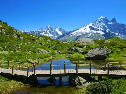
- Pontcysyllte Aqueduct: Thomas Telford and William Jessop’s 1805 aqueduct carries the Llangollen Canal 38 m above the River Dee. It is part of a UNESCO World Heritage Site and can be avoided by an alternative if heights are an issue.
- Llangollen Canal and Horseshoe Falls: The valley-floor return follows the canal towpath past Telford’s curved Horseshoe Falls weir, built to feed water from the Dee into the canal.
Challenges to expect
This is a hard hill circuit: 53 km with about 1,615 m of ascent, steep climbs and long exposed moorland sections. Waymarking is only partial, so carry the guidebook, map and GPS and be ready to navigate in poor visibility. Ground can be rough, boggy and trackless on the heather moors, while weather on the high tops can deteriorate quickly outside the best late-spring to autumn window.
HikeList Score
Llangollen Round scored 86/100 on HikeList's trail-quality metrics.
See score breakdownHide breakdown
- Ideal length 63
- Balanced challenge 84
- Scenery & wildness 98
- Varied terrain 100
- Accommodation 100
- Food & support 74
- Path quality 84
- Season flexibility 89
Computed from length, challenge, scenery & wildness, terrain variety, accommodation, food & support, path quality and season flexibility.
Show more data Show less
- Mountain
- Moorland
- Hills
- Woodland
- Dirt
- Rock
- Gravel
- Paved
- Hotels
- Guesthouses
- Hostels
- Campsites
- Family Friendly
- Pet Friendly
- Water Sources
- Campsites
Download Our Full Guide to Llangollen Round FREE!
Get our comprehensive guide to this hike for free. Save it for later reading or print out at home.
Photos from hikers
Taken on the trail by people who've reviewed Llangollen Round.
Llangollen Round: The Complete Guide
 i
Image by Eyematrix
i
Image by Eyematrix The Llangollen Round is a tough 53 km hill circuit around Dyffryn Llangollen, linking the summits, escarpments and moorland edges above Afon Dyfrdwy (the River Dee). It suits experienced hill walkers who want a compact but serious Welsh route, with repeated climbs and big views rather than an easy valley ramble.
From Llangollen, the route takes in Castell Dinas Brân, Traphont Ddŵr Pontcysyllte (Pontcysyllte Aqueduct), the Creigiau Eglwyseg limestone escarpment and the high ground around Bwlch yr Oernant (Horseshoe Pass). The second half crosses Mynydd Llantysilio, Moel y Gamelin and Moel Fferna, the highest point of the Round, before returning through the Dee Valley and along the Llangollen Canal.
Its appeal is the variety: canal towpath and aqueduct, ruined castle, open heather tops, limestone grassland, woodland, ancient green road and rough Berwyn-edge moor. Llangollen makes the logistics unusually straightforward for a hilly loop, with most walkers basing themselves in town and splitting the route by road, bus, heritage railway or taxi access points.
This is not a beginner’s long weekend. Waymarking is only partial, the moorland can be wet and trackless, and poor visibility on the tops makes a map, GPS and the Judy Smith guide booklet important rather than optional.
This guide covers stages, day splits, accommodation, food, transport, terrain and common planning mistakes.
Stage-by-Stage Guide
The two-stage split below uses the practical break at Bwlch yr Oernant (Horseshoe Pass), roughly halfway round the circuit. It makes two long hill days of about 27 km and 26 km, with repeated climbing, exposed tops and sections where waymarking is not enough on its own.
Stage 1: Llangollen (Allt y Gwernant) to Bwlch yr Oernant / Horseshoe Pass — approx. 27 km
This is a varied first day, moving from the Llangollen side of the Dee Valley into the limestone and heather country north of the town. It starts near the top of Allt y Gwernant above Llangollen, then works through the lower valley landscape before climbing onto the Panorama, Creigiau Eglwyseg and the open moorland around Cyrn-y-Brain.
Early highlights include Froncysyllte, Traphont Ddŵr Pontcysyllte (Pontcysyllte Aqueduct) and Trevor / Trefor. The aqueduct crossing is one of the most memorable parts of the whole Round, carrying the Llangollen Canal high above Afon Dyfrdwy (the River Dee); walkers uneasy with heights can use the signed low-level alternative.
Beyond Trevor the character changes quickly. The route climbs towards the Llangollen Panorama and the long pale limestone edge of Creigiau Eglwyseg, with big views back across Dyffryn Llangollen and the River Dee. The section through World’s End (Eglwyseg) and along the escarpment is more committing than the early valley walking, with rougher ground and more exposure to wind and weather.
The later part of the stage crosses high moorland towards Cyrn-y-Brain, one of the major tops on the circuit at about 564 m. Sir Watkin’s Tower viewpoint is nearby, and in clear weather this section gives wide views across the Dee Valley, the Clwydian hills and towards the Berwyns. The stage finishes at Bwlch yr Oernant (Horseshoe Pass), the A542 mountain pass, with the Ponderosa café acting as the obvious landmark and pick-up point.
Terrain and path conditions: expect a mix of towpath, field paths, escarpment walking, rough grass, heather moor and boggy upland ground. The lower sections are generally more straightforward, but the moorland around World’s End, Creigiau Eglwyseg and Cyrn-y-Brain can be wet, pathless-feeling in places and difficult in mist.
Food and water: Llangollen is the last dependable full-service base before setting out. The Ponderosa café may be useful at the end of the stage, but opening times should be checked before travelling. Carry food and water for the whole day rather than relying on upland streams, villages or seasonal facilities.
Accommodation at the end: there is effectively no on-mountain accommodation at the Horseshoe Pass split. Most walkers using this two-day schedule return to Llangollen by taxi and stay in town, where hotels, guesthouses, B&Bs, a hostel and campsites are available.
Public transport and road access: Llangollen has no mainline railway station; the usual rail approach is to Rhiwabon (Ruabon), then bus to Llangollen. The Horseshoe Pass is a clear road-access point on the A542, but a pre-arranged taxi is the most practical way to end the day there. Local bus, taxi and seasonal transport options should be checked before travelling.
Navigation notes: do not treat the waymarks as sufficient. The aqueduct, canal and Offa’s Dyke Path sections are easier to follow, but waymarking becomes sparse or absent on open moorland. Carry the Judy Smith Llangollen Round guide booklet, OS mapping and a GPS route, and be prepared to navigate by map and compass if cloud drops onto the tops.
Warnings: the aqueduct is high and exposed, though avoidable by the signed low-level alternative. Take care on minor roads and around the A542, and around the ford at World’s End after heavy rain or in icy conditions. The high ground can feel very remote in poor visibility, with boggy going and few sheltered places once committed to the moor.
Stage 2: Bwlch yr Oernant / Horseshoe Pass to Llangollen — approx. 26 km
The second stage is another full hill day and should not be treated as a gentle return to town. It crosses the Mynydd Llantysilio ridge, drops towards the Dee Valley access points around Carrog and Glyndyfrdwy, then climbs again to Moel Fferna, the highest point of the Round at about 625–630 m, before returning through the valley landscape towards Llangollen.
From Bwlch yr Oernant the route heads onto Mynydd Llantysilio and over the chain of summits including Moel y Faen, Moel y Gamelin and Moel Morfydd. Moel y Gamelin, at 577 m, is the highest summit of this sub-range and is marked by a large prehistoric cairn. This is classic exposed ridge walking: rewarding in clear weather, but tiring in wind, low cloud or after a hard first day.
The route then uses the Dee Valley side of the circuit, with Carrog and Glyndyfrdwy providing useful access points before the ground rises again towards the Berwyn foothills. Moel Fferna is the key summit of the day and the highest point of the whole Llangollen Round, reached on the North Berwyn Way section. Expect heather, rough paths, boggy patches and a more remote feel than the valley sections below.
After Moel Fferna the circuit continues by Mynydd Vivod (Vivod Mountain) and turns back towards the Llangollen valley. Abaty Glyn y Groes (Valle Crucis Abbey) lies just below the route and is a short near-route detour rather than a main-line path feature. The return also takes in Rhaeadr y Bedol (Horseshoe Falls), the Llangollen Canal corridor and the steep hill of Castell Dinas Brân before dropping back to Llangollen.
Terrain and path conditions: this stage includes steep ascents and descents, open ridge walking, heather moorland, upland bog, rough summit paths, woodland and easier valley-floor walking near the canal. The canal towpath and Horseshoe Falls section are gentler underfoot, but they come late in the day and should not obscure the amount of high ground already covered.
Food and water: the Ponderosa café may be useful before starting if open, but it should not be relied on without checking current hours. Carrog and Glyndyfrdwy are useful access points, but do not assume food or water will be available exactly when needed. Carry a full day’s supplies from the start and use Llangollen as the dependable resupply point at the end.
Accommodation at the end: Llangollen is the practical overnight base for the finish, with the main local range of hotels, guesthouses, B&Bs, hostel accommodation and campsites. There is no practical reason to plan a wild high-level overnight on this stage, and on-mountain accommodation is effectively absent.
Public transport and road access: the stage starts at a road-access point on the A542, so a pre-booked taxi from Llangollen is the simplest approach. Carrog and Glyndyfrdwy can be useful break or exit points, and the heritage Llangollen Railway serves the Dee Valley in summer, including these locations. Timetables, buses and taxi availability should be checked before travelling.
Navigation notes: the Mynydd Llantysilio ridge and Moel Fferna area need confident hill navigation in mist. The North Berwyn Way section gives a helpful line, but the Round as a whole is only partly waymarked and markers can be sparse on moorland. Keep the guide booklet, OS mapping and GPS to hand even late in the day, especially around junctions between upland paths, valley access routes and the canal return.
Warnings: fatigue is a genuine issue on this stage because the hardest ground is not confined to the morning. The exposed tops of Mynydd Llantysilio and Moel Fferna can catch fast-changing weather, and boggy heather can slow progress sharply after rain. Do not leave the high sections too late in the day unless fully prepared for navigation in darkness.
Recommended Itinerary
The Llangollen Round is most cleanly planned as a town-based walk from Llangollen, using the Horseshoe Pass area as the natural halfway break. There is effectively no on-mountain accommodation, so most walkers either return to Llangollen each night by taxi or use public transport where it fits the chosen access point.
Standard itinerary — 2 days
This is the best fit for strong hill walkers who are comfortable with two long, rough days and can navigate confidently on exposed moorland. The distances are approximate; use the Judy Smith guide booklet, OS mapping and current transport information before booking transfers.
| Day | From | To | Approx. distance | Why this stage makes sense | Services/accommodation notes |
|---|---|---|---|---|---|
| 1 | Llangollen / Allt y Gwernant | Bwlch yr Oernant (Horseshoe Pass) / Ponderosa area | 27 km | This takes in the western and northern side of the circuit, including the early low-level canal and aqueduct section, the climb towards the Panorama, Creigiau Eglwyseg (Eglwyseg escarpment), World’s End and Cyrn-y-Brain before reaching the major road access at the pass. It is a strenuous first day with repeated climbing and exposed ground. | Base in Llangollen and arrange a taxi back from the Horseshoe Pass area, unless a current bus option works for your timing. Do not rely on finding hill accommodation at the pass; this should be checked before travelling. |
| 2 | Bwlch yr Oernant (Horseshoe Pass) / Ponderosa area | Llangollen | 26 km | The second half crosses Mynydd Llantysilio (Llantysilio Mountain), Moel y Faen, Moel y Gamelin and Moel Morfydd before dropping towards the Dee Valley and continuing over the Berwyn-side high ground to Moel Fferna, the highest point of the Round. The return via Mynydd Vivod, Rhaeadr y Bedol (Horseshoe Falls), the Llangollen Canal and the approach back to Llangollen gives a more forgiving finish, but only after a serious upland day. | Stay again in Llangollen after finishing. If leaving a vehicle or arranging collection at the Horseshoe Pass start, confirm taxi availability and pickup point in advance, especially outside busy visitor periods. |
Slower variant — 3 to 4 days
A slower schedule suits walkers who want shorter hill days, more margin for poor visibility, or time to visit places such as Castell Dinas Brân, Traphont Ddŵr Pontcysyllte (Pontcysyllte Aqueduct), Abaty Glyn y Groes (Valle Crucis Abbey) or Rhaeadr y Bedol without rushing. The route can be joined at several road and rail access points, but exact stage splits depend on the current transport and taxi options; check official mapping before booking.
| Day | From | To | Approx. distance | Why this stage makes sense | Services/accommodation notes |
|---|---|---|---|---|---|
| 1 | Llangollen | A chosen access point before or around the northern escarpment section | Check official mapping before booking | Keeps the early climb, canal/aqueduct section and approach to the Panorama manageable, rather than pushing all the way to the Horseshoe Pass in one day. | Stay in Llangollen. Use bus or taxi access where available; current services should be checked before travelling. |
| 2 | Chosen access point | Bwlch yr Oernant (Horseshoe Pass) or another agreed road access point | Check official mapping before booking | Allows more time for Creigiau Eglwyseg, World’s End and Cyrn-y-Brain, which are exposed and navigation-dependent in poor weather. | Return to Llangollen for accommodation. The Horseshoe Pass / Ponderosa area is a practical landmark for pickup, but onward travel must be arranged in advance. |
| 3 | Bwlch yr Oernant or agreed access point | Dee Valley access such as Carrog or Glyndyfrdwy, where it fits the route plan | Check official mapping before booking | Breaks up the high second half over Mynydd Llantysilio, Moel y Gamelin and the Berwyn-side tops, reducing the risk of an overlong final day. | Llangollen remains the practical base. The heritage Llangollen Railway serves Dee Valley points such as Carrog and Glyndyfrdwy in summer, but timetables should be checked before travelling. Taxis may be needed. |
| 4 | Dee Valley access point | Llangollen | Check official mapping before booking | Gives a shorter final stage over the remaining upland ground and the valley-floor return by Rhaeadr y Bedol and the Llangollen Canal. | Finish in Llangollen. If using the railway or bus to reach the start of the day, confirm first and last services before committing to the split. |
Faster variant — 1 long challenge day
A single-day completion is only suitable for very fit walkers with proven hill endurance, early-start discipline and confident navigation. The Round is 53 km with around 1,615 m of ascent, and ascent figures vary between sources, so it should be treated as a full mountain day rather than a long lowland walk.
| Day | From | To | Approx. distance | Why this stage makes sense | Services/accommodation notes |
|---|---|---|---|---|---|
| 1 | Llangollen / Allt y Gwernant | Llangollen | 53 km | Avoids all transfer logistics and keeps the circular route intact, but compresses two hard hill days into one 12–16 hour effort. This is a challenge-walk approach, not the best option for most visitors. | Stay in Llangollen before and after. Carry the guidebook, OS mapping and GPS route data, and plan escape points before starting. Public transport will not remove the need for self-reliance on the exposed tops. |
Planning the Route
The Llangollen Round is easiest to plan as a town-based hill circuit rather than a village-to-village trail. Llangollen is the practical base, with the route starting and finishing above the town near Allt y Gwernant, and most walkers use taxis, buses or the heritage railway to break the loop into manageable days.
The route is not naturally dictated by accommodation on the hills. On-mountain accommodation is effectively absent, so the main planning task is deciding how much rough, exposed ground to take on each day and how to get back to Llangollen afterwards.
How many days to allow
Most independent walkers should allow 2–3 days. A two-day crossing is efficient and uses the Horseshoe Pass / Ponderosa area as the obvious high-level break, but both days are still long and strenuous. Three days gives more margin for poor visibility, slower progress over boggy moorland and time spent finding the line where waymarking is sparse.
A four-day plan works well for walkers who want shorter hill days or who are using public transport and taxis to section the route. A one-day completion is a challenge-walk option for very fit walkers only, typically requiring a long 12–16 hour day and good conditions.
| Plan | How it usually works | Best for | Main caution |
|---|---|---|---|
| 1 long day | Full circuit from Llangollen | Fast challenge walkers | Very long day with little margin for navigation errors or bad weather |
| 2 days | Llangollen to Bwlch yr Oernant / Horseshoe Pass, then back to Llangollen | Strong hill walkers wanting a compact itinerary | Both stages are around a full hill day, with repeated climbs |
| 3 days | Split using road/rail access points and return to Llangollen each night | Most walkers wanting a safer, more flexible plan | Requires transport planning before starting |
| 4 days / sections | Shorter sections based from Llangollen | Section hikers, slower parties, mixed-weather trips | Some access points may need taxis rather than public transport |
The practical two-day split
The cleanest two-day plan is:
| Day | Stage | Approx. distance | Planning notes |
|---|---|---|---|
| 1 | Llangollen / Allt y Gwernant to Bwlch yr Oernant / Horseshoe Pass | 27 km | Crosses the early aqueduct and escarpment sections before the high ground around Cyrn-y-Brain. The Ponderosa area is the natural finish, but onward transport must be arranged. |
| 2 | Bwlch yr Oernant / Horseshoe Pass to Llangollen | 26 km | Takes in Mynydd Llantysilio, the Berwyn foothills, Moel Fferna and the Dee Valley return. This is not an easy “second half”; the highest point of the Round comes on this section. |
This split is logical, but it is still a hard two-day outing. Day two includes Moel Fferna, the highest point of the Round at about 625–630 m, so avoid treating the final return to Llangollen as a simple valley walk.
Walking it quickly or slowly
A fast schedule suits only walkers who are comfortable moving efficiently over rough moorland and navigating without constant waymarks. The route has enough steep climbing, boggy ground and exposed tops that average lowland walking speeds are a poor guide.
A slower schedule is usually better if conditions are uncertain. The route links high points around Dyffryn Llangollen rather than following an easy valley corridor, so poor visibility on the tops can cost time quickly. Extra daylight and a realistic cut-off plan are more useful here than an over-ambitious mileage target.
Section hiking and escape points
Section hiking is practical because the Round can be joined at several road and rail access points. Llangollen remains the best base: stay in town, walk a section, then return by arranged transport.
Useful access areas include Bwlch yr Oernant / Horseshoe Pass, the Dee Valley railway points such as Carrog and Glyndyfrdwy, and the lower-level approaches around Llangollen, Froncysyllte, Trevor and the canal corridor. The heritage Llangollen Railway serves the Dee Valley in summer, while regular buses and taxis make other splits possible. Current timetables and taxi availability should be checked before travelling.
Shortening the route is possible, but not always simple on the open tops. If bad weather develops, the safest option is usually to leave the high ground by a planned road or valley access point rather than improvise across trackless moorland.
Accommodation strategy
Book accommodation in Llangollen unless deliberately arranging a very specific section-walk plan. The town has the useful range of hotels, guesthouses, B&Bs, hostel accommodation and campsites, while the hills themselves do not provide a natural chain of overnight stops.
Because this is a loop, there is no need for an end-to-end transfer. The main accommodation question is whether to stay several nights in Llangollen and use transport to reach daily start and finish points.
Food and water planning
Do not rely on frequent services once committed to the high sections. Llangollen is the main place to buy supplies, and the Ponderosa at Horseshoe Pass is a useful landmark and potential stop, but opening times should be checked before travelling.
Carry enough food and water for a full hill day between reliable resupply points. The moorland sections are exposed and can be slow, so pack for delays rather than for the mapped distance alone.
Navigation planning
Navigation is one of the main planning issues on the Llangollen Round. Much of the route has Llangollen Round waymarks, but they are sparse or absent across open moorland, and the tops can become difficult in poor visibility.
Carry the Judy Smith Llangollen Round guide booklet, suitable OS mapping and a GPS route as backup. The OS Explorer coverage spans sheets 240, 255, 256 and 264, so check map coverage before setting off rather than assuming a single sheet will be enough.
Transport planning
Llangollen has no mainline railway station. The nearest mainline station is Rhiwabon (Ruabon) on the Chester–Shrewsbury line, with onward buses into Llangollen; buses also run from Wrecsam (Wrexham). The Arriva number 5 and T3 TrawsCymru services are the key bus options to check.
For section walking, the summer Llangollen Railway can help with Dee Valley access, including points such as Carrog and Glyndyfrdwy. Other access points may require taxis, especially if finishing a high-level section late in the day. This should be arranged before starting the walk, not from the hill.
Weather, access and permissions
No special permit is normally the deciding factor for planning this walk; weather and access conditions matter far more. The high ground around Cyrn-y-Brain, Mynydd Llantysilio and Moel Fferna is exposed to fast-changing conditions, and the boggy sections can be much slower after wet weather.
Check the hill forecast before committing to the tops, especially for wind, low cloud and visibility. Any temporary access-land restrictions or local closures should be checked before travelling.
Towns, Villages and Overnight Stops
The Llangollen Round is best planned as a town-based hill circuit rather than a hut-to-hut or village-to-village route. Accommodation on the hills is effectively absent, and the practical pattern is to stay in Llangollen, then use taxis, buses or the heritage railway to split the route at access points.
For a two-day itinerary, the natural break is the Bwlch yr Oernant / Horseshoe Pass area near the Ponderosa. Most walkers will still need to transfer back to Llangollen or another booked base for the night, rather than sleep at the pass.
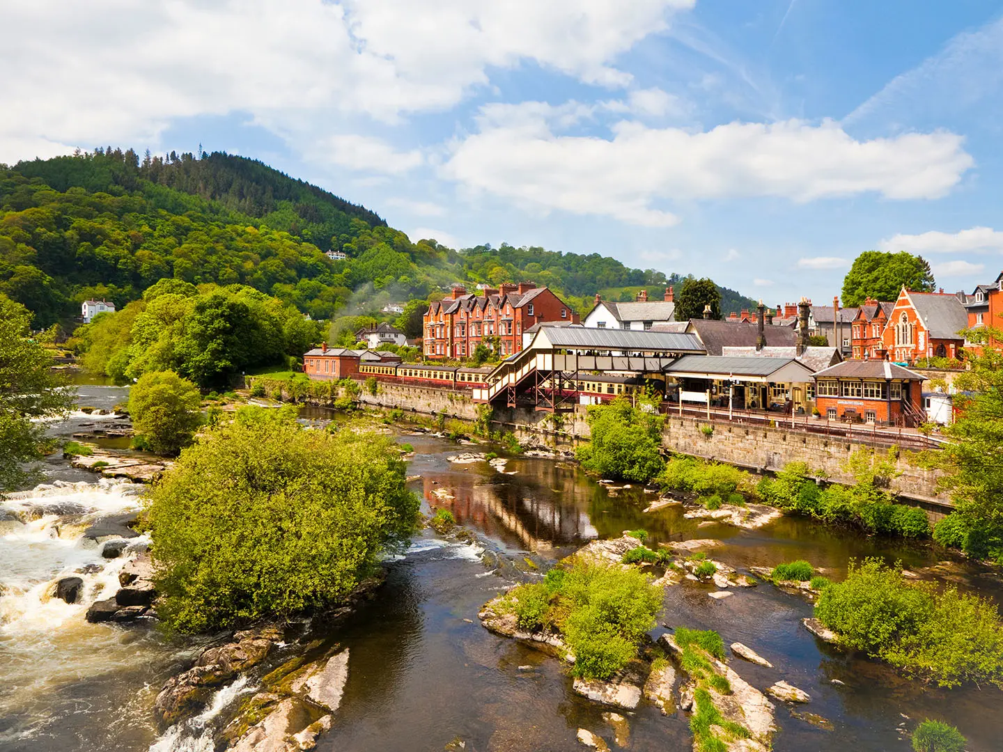
Llangollen
Llangollen is the main base for the whole route and the only place on the Round with a broad accommodation choice. Hotels, guesthouses, B&Bs, a hostel and campsites are available in or around the town, making it the most straightforward place to stay before, during and after the walk.
The route starts and finishes above the town near the top of Allt y Gwernant, but most logistics work better from the town centre. Use Llangollen for evening meals, packed-lunch planning and any last-minute supplies; individual opening times should be checked before travelling, especially for early starts.
Llangollen has no mainline railway station. The usual public-transport approach is by train to Rhiwabon (Ruabon) on the Chester–Shrewsbury line, then bus into Llangollen, including the Arriva number 5 or T3 TrawsCymru service. Buses also run from Wrecsam (Wrexham); current timetables should be checked before travelling.
Because the route is a loop, Llangollen also works well for section-hiking. Taxis can be used to reach or leave the more remote road-access points, while lower Dee Valley access may be possible by bus or, in season, the Llangollen Railway.
Froncysyllte, Traphont Ddŵr Pontcysyllte and Trevor / Trefor
Froncysyllte, Traphont Ddŵr Pontcysyllte (Pontcysyllte Aqueduct) and Trevor / Trefor sit early on the Round, where the route crosses the Llangollen Canal and the Afon Dyfrdwy (River Dee) corridor before climbing towards the Panorama and Eglwyseg hills. This is one of the easiest parts of the circuit to reach from the valley.
These places are more useful as access or bailout points than as core overnight stops. Accommodation and food options should be checked before travelling if planning to stop here, as the main reliable base for the Round remains Llangollen.
The aqueduct crossing is a major landmark and part of the route, with a signed low-level alternative for anyone uneasy with heights. If splitting the Round into shorter sections, this valley-side area can be useful for joining or leaving the walk without committing immediately to the higher moorland.
Llangollen Panorama, World’s End and Creigiau Eglwyseg
The Panorama road, World’s End and Creigiau Eglwyseg (Eglwyseg escarpment) form a long, high and exposed section rather than a village-based stopping area. Expect open hill country, limestone escarpment edges and limited practical shelter once away from the road.
This is not a sensible overnight area for most walkers. There is no dependable on-route accommodation on the tops, and food, water and transport options should not be assumed.
World’s End can be useful as a road-access point for strong walkers breaking the Round into shorter sections. Taxi arrangements should be made in advance, and mobile reception should not be relied on for last-minute pickups.
Bwlch yr Oernant / Horseshoe Pass and the Ponderosa
Bwlch yr Oernant (Horseshoe Pass) is the most useful halfway break on the standard two-day schedule. It sits on the A542 high above Llangollen and is a natural place to end or begin a day because the Round passes through the pass area near the Ponderosa.
The Ponderosa cafe is the key service here, but it should be treated as a daytime refreshment stop rather than a guaranteed overnight solution. Opening times and any current facilities should be checked before travelling.
For most walkers, this is a transfer point back to Llangollen or a pre-booked base. Arrange taxis in advance, especially if arriving late after the first half of the Round, as the surrounding hills are exposed and the route onwards over Mynydd Llantysilio is committing in poor weather.
Carrog
Carrog lies in the Dee Valley section after the Llantysilio Mountain tops and before the Round turns towards the Berwyn foothills. It is one of the more useful valley access points on the later part of the route.
The heritage Llangollen Railway serves Carrog in summer, making it potentially useful for section walkers or for shortening the Round. Timetables are seasonal and should be checked before travelling.
Do not rely on Carrog as an overnight stop without advance booking. Accommodation, food and shop availability should be checked directly before building a day plan around the village.
Glyndyfrdwy
Glyndyfrdwy is another Dee Valley access point on the later half of the circuit. It is useful because the route order brings walkers through the valley before the climb towards Moel Fferna, the highest point of the Round.
The Llangollen Railway serves Glyndyfrdwy in summer, so it can work as a join or leave point for walkers splitting the Round. Current railway operating days and times should be checked before travelling.
As with Carrog, Glyndyfrdwy should not be assumed to provide all the services needed for an overnight stop. Book accommodation in advance if staying locally, or plan a transfer back to Llangollen.
Abaty Glyn y Groes, Rhaeadr y Bedol and the Llangollen Canal
Abaty Glyn y Groes (Valle Crucis Abbey) sits just below the route and is a short near-route detour rather than a core overnight stop. It is best treated as a landmark or rest point on the return towards Llangollen.
Rhaeadr y Bedol (Horseshoe Falls) and the Llangollen Canal come late in the Round, after the higher Berwyn-side walking. This section is more sheltered and lower than the moorland tops, but it is close enough to Llangollen that most walkers continue back to town rather than stop overnight.
If the weather closes in on the final hills, this valley corridor can be a useful place to regain easier ground. Any onward transport or pickup should still be planned in advance rather than left to chance.
Castell Dinas Brân
Castell Dinas Brân is on the Round above Llangollen and is a landmark rather than a settlement. There are no overnight services on the hill itself, so it should be treated as part of the Llangollen start or finish logistics.
Its position directly above town makes it useful for timing the beginning or end of the route. If arriving in Llangollen late, many walkers will be better saving the full Round for the following day rather than starting tired onto the exposed high-level circuit.
Getting to the Start
By train
Llangollen has no mainline railway station. The nearest practical railhead is Rhiwabon (Ruabon), on the Chester–Shrewsbury line, followed by a bus or taxi into Llangollen.
Wrecsam (Wrexham) is another useful rail-and-bus gateway, particularly if services to Rhiwabon do not line up well with your arrival time. From outside the area, plan rail travel via Chester, Shrewsbury or Wrecsam, then make the final connection into Llangollen by bus or taxi.
The heritage Llangollen Railway serves the Dee Valley, including places such as Carrog and Glyndyfrdwy, and can be useful for splitting the Round or accessing one of the route’s valley points in summer. It should not be treated as the default way to reach the start unless its timetable works for your walking plan. This should be checked before travelling.
By bus
Llangollen is linked to Rhiwabon (Ruabon) by the Arriva number 5 and the T3 TrawsCymru bus. Buses also run from Wrecsam (Wrexham) to Llangollen.
For most walkers arriving by public transport, the simplest plan is:
| Step | Practical route |
|---|---|
| 1 | Train to Rhiwabon (Ruabon), or to Wrecsam (Wrexham) if that gives better connections |
| 2 | Bus into Llangollen town centre |
| 3 | Walk or take a local taxi up towards the route start near Allt y Gwernant if required |
Bus times, evening services and Sunday/holiday services can change, and missed connections may leave a long wait. This should be checked before travelling, especially if arriving late or planning to begin walking the same day.
By car
The Llangollen Round is a loop, so there is no end-to-end vehicle shuttle to arrange if you start and finish in Llangollen. The formal start/finish is near the top of Allt y Gwernant above the town, at grid reference SJ225397, but Llangollen town centre is the practical base for accommodation, food and transport.
Do not assume that the hill start itself is suitable for leaving a vehicle for multiple days. If driving, arrange overnight or long-stay parking in Llangollen through your accommodation or a suitable local car park before setting off. This should be checked before travelling.
A car is useful if you want to break the Round at road access points, but it is not essential. Regular buses serve some points on or near the route, the Llangollen Railway can help with some Dee Valley access in season, and taxis are the practical option for the less well-served access points.
From the nearest airport
There is no airport at Llangollen. For air arrivals, the practical approach is to reach the regional rail network first, then travel by train to Rhiwabon (Ruabon) or Wrecsam (Wrexham), followed by bus or taxi into Llangollen.
Airport choice, rail connections and late-arrival options should be planned around the Rhiwabon/Wrecsam onward connection rather than the walk start itself. This should be checked before travelling.
Where to stay before starting
Llangollen is the best place to stay before starting the Round. The town has a good range of hotels, guesthouses, B&Bs, a hostel and campsites, and staying in town keeps you close to shops, food, buses and taxis.
Because accommodation on the hills is effectively absent, most walkers base themselves in Llangollen and use transport to split the circuit into manageable days if they are not walking it as a continuous two-day round. Book early for weekends and busy holiday periods, and check whether your accommodation can advise on legal overnight parking or local taxi options.
Getting Home from the Finish
The Llangollen Round is a loop, so there is no end-to-end transfer at the finish. Most walkers finish back in Llangollen, usually after the valley return via Rhaeadr y Bedol (Horseshoe Falls), the Llangollen Canal and the Dee Valley, then leave from the town centre or stay overnight.
If the route has been started from the formal high point above town near Allt y Gwernant, allow for the final movement between the hill start/finish area and Llangollen town centre. Public transport is centred on the town, not the open hillside.
By train
Llangollen has no mainline railway station. The nearest mainline station is Rhiwabon (Ruabon), on the Chester–Shrewsbury line.
From Llangollen, use the Arriva number 5 or the T3 TrawsCymru bus towards Rhiwabon (Ruabon), or take a taxi if the timing is awkward. From Rhiwabon, trains connect along the Chester–Shrewsbury line, with onward connections for wider UK travel.
Wrecsam (Wrexham) is also a practical rail/bus hub for leaving the area, with buses running between Wrecsam and Llangollen. Exact train and bus times should be checked before travelling, especially for Sunday, bank-holiday or evening finishes.
By bus
Buses are the main public-transport link out of Llangollen. The key services for most walkers are the Arriva number 5 and the T3 TrawsCymru, linking Llangollen with Rhiwabon (Ruabon), and buses also run from Llangollen towards Wrecsam (Wrexham).
Although the Llangollen–Ruabon link is described as frequent, do not rely on turning up late after a long hill day without checking the last departure. The Round has exposed, navigation-dependent moorland sections, so delays are realistic in poor visibility or bad weather.
The heritage Llangollen Railway serves the Dee Valley, including places such as Carrog and Glyndyfrdwy, in summer and can be useful for splitting the walk. It should not be treated as the default way home from the finish unless its seasonal timetable fits the day’s plan.
By car/taxi
Because the walk is circular, driving logistics are simpler than on a linear trail: leave the car in or near Llangollen, complete the circuit, and return to the same base. Parking arrangements in Llangollen should be decided before setting off rather than improvised at the end of a long day.
Taxis are useful if finishing late, if accommodation is outside the town centre, or if the walk has been split using road access points such as Bwlch yr Oernant (Horseshoe Pass). Taxi availability should be checked before travelling, and pre-booking is sensible for early starts, evening collections or multi-day section plans.
From the nearest airport
There is no direct airport-style finish logistics for this route. The practical way out is first to reach Rhiwabon (Ruabon) or Wrecsam (Wrexham) by bus or taxi, then continue by rail via the Chester–Shrewsbury line and onward national connections.
Anyone flying should plan the airport connection from the rail network rather than from Llangollen itself. Airport rail and coach connections, and the final bus back from Llangollen, should be checked before travelling.
Where to stay at the finish
Staying in Llangollen after the Round is often the most sensible option, particularly after a two-day or challenge-style completion. The town has a good range of hotels, guesthouses, B&Bs, a hostel and campsites, and it avoids a rushed transfer after a strenuous final day.
An overnight stop also gives a buffer if the high sections over Mynydd Llantysilio, Moel Fferna or Mynydd Vivod take longer than planned. For walkers using public transport, it is safer to book accommodation than to depend on catching the last bus after a weather-affected finish.
Which Direction Should You Walk?
The Llangollen Round can be walked in either direction, and there is no end-to-end transfer to solve because it is a loop. There is also no strong transport reason to reverse it: Llangollen remains the practical base, and the same road, bus, railway and taxi access points apply whichever way you walk.
For most walkers, the best choice is the standard route order used by the main two-day split: Llangollen / Allt y Gwernant to Traphont Ddŵr Pontcysyllte (Pontcysyllte Aqueduct), Creigiau Eglwyseg, Cyrn-y-Brain and Bwlch yr Oernant (Horseshoe Pass), then over Mynydd Llantysilio, Moel Fferna and Mynydd Vivod before returning by the Dee Valley and Llangollen Canal.
Standard direction
The standard direction gives the walk a logical progression. It starts with the lower Dee Valley landmarks and the aqueduct, moves onto the long limestone edge of Creigiau Eglwyseg and World’s End, then reaches the Horseshoe Pass area as a natural halfway break.
The second half feels wilder and more committing, with Mynydd Llantysilio and Moel Fferna — the highest point of the Round — coming after the pass. Finishing by the Dee Valley and canal is psychologically useful: after the last high ground, the route unwinds onto easier valley-floor walking back towards Llangollen.
For a two-day itinerary, Bwlch yr Oernant / the Ponderosa area works well as the dividing point in this direction. It splits the Round into two similar-length days and gives a clear road access point for a taxi pick-up or drop-off.
Reverse direction
Walking the Round in reverse is perfectly viable, but it changes the feel of the walk. The high Berwyn and Mynydd Llantysilio ground comes earlier, so the rougher, boggier and more exposed sections are not left until late in the route.
This can be an advantage if the forecast is better at the start of the trip and due to deteriorate later. It can also suit walkers who want to finish with Creigiau Eglwyseg, the Panorama area and Pontcysyllte Aqueduct rather than the canal approach into Llangollen.
The main drawback is that the reverse direction loses the gentler canal-side return as a natural wind-down. If walking long days, ending with the aqueduct and escarpment side of the circuit may feel less forgiving when tired, especially for anyone uneasy with heights at Pontcysyllte, although a signed low-level alternative is available there.
Transport and accommodation
Direction makes little difference to accommodation planning because most walkers base themselves in Llangollen rather than staying out on the hills. On-mountain accommodation is effectively absent, so the key decision is where to leave and rejoin the route each day.
Bwlch yr Oernant / Horseshoe Pass is the most obvious halfway access point for a two-day walk. Other road, bus and rail-linked access points allow the Round to be split into shorter sections, with the heritage Llangollen Railway serving parts of the Dee Valley in summer and regular buses reaching two points on the route. Current bus, railway and taxi options should be checked before travelling.
Weather and navigation
There is no reliable directional advantage for wind or weather. The tops are exposed in both directions, and poor visibility can make the partly waymarked moorland sections difficult regardless of whether you walk clockwise or anti-clockwise.
If the forecast is marginal, choose the direction that puts the highest and most exposed ground — especially Cyrn-y-Brain, Mynydd Llantysilio and Moel Fferna — into the best weather window. Carry the Judy Smith guide booklet, OS mapping and GPS navigation whichever way you go.
Recommendation
Walk the Llangollen Round in the standard direction unless there is a clear weather, transport or personal reason to reverse it. The standard order gives the cleanest scenery progression, a practical halfway break at Bwlch yr Oernant / Horseshoe Pass, and the most satisfying finish back into Llangollen via the Dee Valley and canal.
Accommodation Along the Route
The Llangollen Round is best planned as a town-based walk, not a point-to-point inn-to-inn trail. Llangollen has the useful accommodation choice: hotels, guesthouses, B&Bs, a hostel and campsites, plus the services needed before and after long hill days.
Accommodation on the high parts of the circuit is effectively absent. The practical approach is to sleep in Llangollen and use taxis, buses or the summer Llangollen Railway to reach or leave day sections at road and rail access points.
Best overnight base
For most walkers, Llangollen town centre is the obvious base for the whole route. The official start is above town near Allt y Gwernant, but staying in the town centre gives easier access to food, transport and taxis.
This works especially well for walkers taking 2, 3 or 4 days over the Round. Rather than carrying overnight kit across the open tops, you can return to Llangollen after each section and start the next day from the previous exit point.
Accommodation by place
| Place | Accommodation level | Best for | Notes |
|---|---|---|---|
| Llangollen | Good | Main base before, during and after the walk | Best choice of hotels, guesthouses, B&Bs, hostel and campsites. Most walkers should book here and use transport to split the Round. |
| Froncysyllte / Trevor (Trefor) / Pontcysyllte Aqueduct area | Limited / check | Early-route access or low-level alternatives | Useful on the route, but not the main accommodation base. Do not rely on a same-day bed without checking availability before travelling. |
| Llangollen Panorama / World’s End / Creigiau Eglwyseg | None on the hill | Day-walk section only | High-level and exposed ground with no practical overnight stop on the route. Plan to continue to an access point or arrange a pick-up. |
| Bwlch yr Oernant (Horseshoe Pass) / Ponderosa area | None for route-planning purposes | Midpoint break and taxi pick-up/drop-off | A natural halfway landmark for a 2-day split, but not a dependable overnight base. Most walkers return to Llangollen by taxi from here. |
| Mynydd Llantysilio / Moel y Faen / Moel y Gamelin / Moel Morfydd | None | Hill section only | Exposed upland walking with no accommodation on the route. Carry full hill kit and plan exits carefully. |
| Carrog / Glyndyfrdwy | Limited / check | Rail-access section split in season | The Llangollen Railway serves the Dee Valley in summer and can help with section logistics. Accommodation should not be assumed; this should be checked before travelling. |
| Moel Fferna / Mynydd Vivod | None | Remote hill section | No on-mountain accommodation. Navigation and weather planning matter here, especially if finishing late. |
| Valle Crucis / Rhaeadr y Bedol (Horseshoe Falls) / canal return | Limited / check | Final-day access near Llangollen | Close enough to Llangollen for most walkers to continue back to town rather than overnighting nearby. Check options before building a stage around them. |
Booking strategy
Book Llangollen accommodation in advance, particularly for weekends, holiday periods and good-weather spring-to-autumn walking windows. The town is the natural base for the Vale of Llangollen, the canal, Castell Dinas Brân and nearby attractions, so last-minute choice can be restricted.
If camping, check the campsite’s opening dates, booking requirements and arrival rules before travelling. Do not assume a late arrival will be possible after a long day on the tops.
Using taxis and transport to solve awkward gaps
The Round’s accommodation problem is solved more by transfers than by changing overnight stops. The key break for a 2-day itinerary is the Bwlch yr Oernant / Horseshoe Pass area, where many walkers arrange a taxi back to Llangollen, then return the next morning to continue.
For a 3- or 4-day schedule, the road and rail access points allow shorter hill days. Regular buses reach some points on or near the route, and the Llangollen Railway can be useful in summer for Dee Valley access such as Carrog and Glyndyfrdwy. Current bus times, railway operating days and taxi availability should be checked before travelling.
Does it work as an inn-to-inn walk?
Not really. The Llangollen Round is a high-level circuit with long exposed sections and no reliable chain of overnight stops around the hills.
It can be made to feel like a multi-day route by staying several nights in Llangollen and using transfers each day. This is usually simpler, lighter and more reliable than trying to force an inn-to-inn itinerary around places with limited or uncertain accommodation.
Camping and Wild Camping
Best camping strategy
The Llangollen Round is better treated as a town-based walk than a backpacking route. Llangollen has campsites as well as hotels, guesthouses, B&Bs and a hostel, so the simplest plan is to camp in or near the town and use taxis, buses or the heritage railway access points to split the circuit into day walks.
This works especially well because the route is a loop and returns to Llangollen. It also avoids carrying a full overnight load over steep, boggy and exposed tops such as Cyrn-y-Brain, Mynydd Llantysilio and Moel Fferna.
There is effectively no on-mountain accommodation on the Round. Do not plan on finding huts, bothies or formal camping places on the high sections.
Campsites on or near the route
Formal camping is most practical around Llangollen rather than on the hills. Campsite opening dates, booking rules and whether they accept backpacking tents should be checked before travelling, especially outside the main spring-to-autumn walking season.
For a 2-day itinerary, many walkers will be better off leaving the tent at a Llangollen campsite and arranging transport to or from the Horseshoe Pass / Bwlch yr Oernant area. For a 3- or 4-day itinerary, any overnight stops away from Llangollen need to be planned around road or rail access points rather than assumed camping on the route itself.
Wild camping: legality and practical reality
Wild camping is not a dependable option on the Llangollen Round. In Wales, there is no general right to wild camp without the landowner’s permission, and the Round crosses a mix of farmland, open moorland, access land, woodland edges and protected landscape within the Clwydian Range and Dee Valley National Landscape / AONB.
Open access land does not automatically give permission to camp. If you want to camp away from a formal site, obtain clear landowner permission in advance; otherwise use an official campsite. Local restrictions, temporary closures and estate rules should be checked before travelling.
Avoid any idea of pitching on sensitive or busy parts of the route, including around Castell Dinas Brân, Traphont Ddŵr Pontcysyllte (Pontcysyllte Aqueduct), the Llangollen Canal towpath, Rhaeadr y Bedol (Horseshoe Falls), Abaty Glyn y Groes (Valle Crucis Abbey), road passes, car parks and café areas. These are not suitable wild-camping spots.
If permission is granted
If a landowner gives permission, keep the camp small, discreet and low-impact. Arrive late, leave early, avoid stock, gates, walls and buildings, and do not damage heather, bog or grassland.
Fires are not appropriate on this route. Heather moorland and dry grass can be easily damaged, and fire risk can rise quickly in warm, dry weather. Use a stove only where it is safe and permitted, and never on peat, heather or unstable ground.
Water and waste
Do not rely on the high-level sections for safe drinking water. The route crosses wet, boggy moorland and later returns by the Afon Dyfrdwy (River Dee) and Llangollen Canal, but this does not mean potable water is available.
Carry enough water from Llangollen or from known road-access services, and treat any natural water if used. Café or village refills should not be assumed without checking opening times and access in advance.
Pack out all litter, food waste and toilet paper. If toileting outdoors is unavoidable, go well away from paths, watercourses, walls, buildings and grazing areas, and leave no visible trace.
Does the Round suit backpacking?
Only experienced hill walkers should consider backpacking the Round, and even then it is awkward rather than ideal. The route is only partly waymarked, crosses rough moorland, and has long exposed sections where poor weather can make navigation and progress slow.
A heavy pack will make the repeated climbs noticeably harder. For most walkers, a lightweight day-pack from a Llangollen base is the more sensible, safer and lower-impact approach.
Food, Water and Resupply
The Llangollen Round is best treated as a self-sufficient hill walk between Llangollen and the Horseshoe Pass, with Llangollen as the main place to buy food before and after each stage. Do not assume regular shops or cafés on the high sections: much of the route is on open moorland, escarpment paths and exposed summits.
The one obvious mid-route refreshment point is the Ponderosa café at Bwlch yr Oernant (Horseshoe Pass), which makes it a practical halfway break on the common 2-day itinerary. Opening times can vary by season, day of week and weather, so it should be treated as a useful bonus rather than the only food plan. This should be checked before travelling.
How much to carry
For the standard 2-day split, carry a full hill day’s food from the start of each stage: lunch, high-energy snacks and an emergency reserve. The two days are both around 26–27 km with repeated climbs, so food needs are closer to a mountain day than a lowland towpath walk.
A sensible starting point is 1.5–2.5 litres of water per person for each day, increasing in warm weather or if walking the route as a one-day challenge. There are long exposed sections where there may be no reliable potable refill point, especially across Creigiau Eglwyseg, Cyrn-y-Brain, Mynydd Llantysilio and the Berwyn foothills around Moel Fferna.
Water sources
Reliable drinking water should be filled in Llangollen before setting out and, if open, at staffed premises such as the Ponderosa café. Do not rely on finding public taps on the route unless a specific refill point has been arranged or checked in advance.
Natural water is present in the wider landscape — the route returns through the Afon Dyfrdwy (River Dee) valley and follows the Llangollen Canal — but these should not be treated as safe drinking sources without proper filtration or purification. Moorland water can also be affected by peat, livestock and agricultural run-off, so filtering or boiling is needed if it is used in an emergency.
Resupply by section
| Section | Food availability | Water availability | Notes |
|---|---|---|---|
| Llangollen / Allt y Gwernant start | Best place to buy food before the route. Use Llangollen as the main resupply base. | Fill bottles before leaving town. | Most walkers should start with a full day’s food and water, even if expecting to stop later. |
| Llangollen to Froncysyllte, Traphont Ddŵr Pontcysyllte and Trevor / Trefor | Possible valley-side services may exist, but do not plan around them without checking. | No guaranteed refill point on the trail. | Early low-level sections can feel close to settlement, but the route soon commits to higher ground. |
| Trevor / Trefor to Panorama, World’s End, Creigiau Eglwyseg and Cyrn-y-Brain | Very limited once on the escarpment and moorland. Carry everything needed. | No reliable potable water on the tops. | One of the key dry-planning sections: exposed, high and slow in poor weather. |
| Bwlch yr Oernant / Horseshoe Pass / Ponderosa | Ponderosa café is the main practical food stop on the Round. | Refill may be possible if the café is open. | Check opening times before committing to it as lunch or resupply, especially outside peak season or on Sundays. |
| Horseshoe Pass to Mynydd Llantysilio, Moel y Faen, Moel y Gamelin and Moel Morfydd | No dependable food on the ridge. | No dependable potable water on the ridge. | Start this section with enough food and water to reach the Dee Valley or Llangollen, depending on the day plan. |
| Carrog / Glyndyfrdwy access area to Moel Fferna | Treat as limited for food unless using a pre-arranged stop or transport link. | Do not assume a refill before the climb to Moel Fferna. | This is a poor place to run short: Moel Fferna is the highest point of the Round and the ground can be boggy and slow. |
| Mynydd Vivod, Rhaeadr y Bedol, Llangollen Canal and return to Llangollen | Food becomes easier again once back in Llangollen. | Canal and river water are not drinking water unless treated. | Keep enough water for the valley return; the towpath is easier walking but can still take time at the end of a long day. |
Practical resupply strategy
For a 2-day walk, the simplest plan is to carry packed food from Llangollen on both mornings and use the Ponderosa only if its opening hours fit the day. For a 3- or 4-day version using taxis, buses or rail access points, Llangollen remains the easiest base for buying supplies between sections.
Rural opening hours can be short, seasonal and more limited on Sundays and bank holidays. Any plan depending on a café, pub, shop or refill point away from Llangollen should be checked before travelling.
Terrain, Conditions and Difficulty in Practice
The Llangollen Round is hard because it is repeatedly hilly rather than because it is technically difficult. There is no indication that scrambling is required, but the route links steep valley climbs, exposed moorland tops, rough summit paths and wet, boggy ground, with only partial waymarking.
HikeList uses 1,615 m of total ascent, although ascent figures vary between route trackers. In practice, the important point is that the climbing is spread across many separate tops and ridges, so tired legs have to deal with repeated descents and re-ascents rather than one single mountain day.
Underfoot: what the route actually feels like
| Part of the Round | Typical terrain | Practical difficulty |
|---|---|---|
| Llangollen, the Dee Valley and canal sections | Valley paths, canal towpath and easier low-level going | The simplest walking on the Round, useful for making steady time, though not representative of the hill sections. |
| Traphont Ddŵr Pontcysyllte (Pontcysyllte Aqueduct) | Canal-side crossing high above Afon Dyfrdwy (River Dee) | Exposed to height rather than technically hard; a signed low-level alternative exists for walkers uneasy with the aqueduct crossing. |
| Castell Dinas Brân and the hills above Llangollen | Short, steep hill ground above the town | Sharp climbs early or late in the route depending on direction; expect slower progress than the map distance suggests. |
| Panorama, Creigiau Eglwyseg and World’s End | Limestone grassland, escarpment edges, open hillside and some road-side/track sections | Generally more defined than the boggier moors, but exposed in poor weather and with care needed near escarpment edges. |
| Cyrn-y-Brain, Mynydd Llantysilio, Moel y Faen, Moel y Gamelin and Moel Morfydd | Open heather moorland, rough summit paths and repeated climbs | Physically demanding, exposed and slower underfoot; waymarks may be sparse away from clearer paths. |
| Moel Fferna and the Berwyn foothills | High, heather-clad moorland with upland bog and rough going | The most serious-feeling terrain on the Round: wet ground, exposure and navigation all matter here, especially in cloud or rain. |
| Return by Mynydd Vivod, Rhaeadr y Bedol and the canal | Hill descent followed by easier valley-floor walking | The canal return helps with pace, but it comes after the harder upland work and should not be treated as a guaranteed easy finish if tired. |
Mud, bog and wet ground
Wet ground is a real planning factor on this route. The moorland and Berwyn sections can be boggy and in places rough or trackless, especially away from well-used paths.
Waterproof boots or very robust trail shoes are more appropriate than lightweight urban footwear. Gaiters can be useful after rain, and spare dry socks are sensible on a multi-day itinerary.
After prolonged wet weather, the moorland sections are likely to take longer than their distance suggests. Build in time for slower foot placement, detours around saturated patches and extra navigation checks.
Climbs, descents and pace
The Round repeatedly drops from high ground towards passes, valleys or access points before climbing again. This makes it more tiring than a route of similar distance on a single ridge.
The climb to Castell Dinas Brân is short but steep. Later, the high ground around Cyrn-y-Brain, Mynydd Llantysilio, Moel y Gamelin and Moel Fferna gives the route its sustained hill-walking character.
A fit walker may cover the 53 km quickly in good visibility and dry conditions, but most walkers should pace it as a serious hill circuit. A 2-day schedule gives two long, strenuous days; 3 or 4 days makes the terrain and navigation more forgiving.
Exposure and weather
The tops are open and exposed, with little shelter on the higher moorland. Weather can change quickly, and cloud on the summits can turn a straightforward line into a navigation problem.
Wind, rain and low cloud make the Round substantially harder. In poor visibility, the combination of heather, bog and sparse waymarking means a map, compass, guidebook and reliable GPS track are not optional extras.
The route is best treated as a spring, summer or autumn hill walk. Even in summer, carry waterproofs and warm layers for the high sections rather than dressing only for conditions in Llangollen town centre.
Waymarking, gates and route-finding
The Llangollen Round is only partly waymarked. Logos are present on much of the route, but marks can be sparse or absent across open moorland, where the Judy Smith guide booklet and OS mapping are the main tools for staying on line.
The route uses a mixture of paths, tracks, open access-style hill ground, canal towpath and road/access links. Expect normal countryside barriers such as gates and boundary crossings, and take extra care to close gates where the route passes through enclosed land.
Do not rely on following footprints across the tops. In mist, heather and bog can make informal trods hard to distinguish, so regular position checks are needed before leaving a clear path or track.
Road walking and hard surfaces
This is not a road walk, but there are hard-surface sections around Llangollen, the canal corridor, the Panorama area and access points such as Bwlch yr Oernant (Horseshoe Pass). These sections can help with pace but can also feel punishing late in the day after rough moorland.
Take care where the route interacts with roads and pass areas, particularly around the A542 at Bwlch yr Oernant. Current access arrangements and safe pick-up points should be checked before travelling if splitting the Round by taxi or public transport.
What makes it easier or harder
Dry, clear weather makes the Round much more manageable: paths are easier to follow, boggy sections are less draining and the escarpment and summit navigation is more straightforward. Long daylight also matters, particularly for a 2-day itinerary.
The route becomes significantly harder in rain, low cloud or strong wind. The main risks are not technical climbing hazards, but slow progress, poor visibility, fatigue on repeated climbs and navigation errors on open moorland.
For most independent walkers, the realistic difficulty sits between a long-distance path and a mountain circuit. The canal and valley sections are gentle, but the full Round is a strenuous, self-reliant hill walk and should be planned accordingly.
Weather and Best Time to Walk
The Llangollen Round is best planned for spring, summer or autumn, when there is enough daylight for long hill days and the high moorland sections are less likely to be affected by winter conditions. The route reaches around 625–630 m on Moel Fferna and includes long exposed tops such as Cyrn-y-Brain, Mynydd Llantysilio, Moel y Gamelin and the Berwyn foothills, so valley weather in Llangollen is not a reliable guide to conditions on the summits.
The most dependable walking window is late spring to early autumn. Summer gives the longest daylight and the best chance of completing the route over two long days, but it can still be wet, windy and misty on the tops. Autumn can be excellent, though shorter days make the 27 km / 26 km two-day split more demanding.
Seasonal planning
| Season | What to expect | Planning advice |
|---|---|---|
| Spring | Longer days returning, but wet ground can remain on the moors. Weather can change quickly on the exposed ridges and summits. | A good time for fit walkers if carrying full waterproofs and warm layers. Allow extra time across boggy or indistinct ground. |
| Summer | Best daylight for a 2-day crossing and the easiest season for transport and town-based logistics. Heat is possible in the valley, but wind and rain remain realistic on the tops. | Start early, carry enough water between access points, and do not rely on waymarks across open moorland. Book Llangollen accommodation ahead for busy periods. |
| Autumn | Cooler walking conditions and often good visibility between weather systems, but daylight reduces quickly. Moorland can become wetter and slower. | A strong option for a 3-day or 4-day itinerary. For a 2-day attempt, keep a strict eye on daylight and have escape points planned. |
| Winter | Short days, cold wind, poor visibility, saturated bog, ice or snow are all possible on the higher ground. Navigation is harder because waymarking is only partial. | Not the normal season for this route. A winter Round is only realistic for experienced winter hill walkers with appropriate equipment and a conservative plan. |
Wind, rain and visibility
The biggest weather issue is not altitude alone, but exposure combined with navigation. Much of the route is on open heather moorland, rough summit paths and boggy ground, where low cloud or hill fog can make the line difficult to follow. Waymarks are sparse or absent in places, so poor visibility should be treated as a serious factor, not an inconvenience.
Strong wind is most important on the higher and more open parts of the circuit, including the Eglwyseg escarpment, Cyrn-y-Brain, Bwlch yr Oernant (Horseshoe Pass), Mynydd Llantysilio and Moel Fferna. In high winds, exposed ridges and escarpment edges can become tiring and uncomfortable, and progress across rough ground slows quickly.
After rain, expect the moorland sections to be wet underfoot. The route includes upland bog and rough, sometimes trackless ground, so waterproof boots, gaiters and poles can be useful. The lower valley return beside the Llangollen Canal is easier going, but it should not be used as a guide to the conditions higher up.
Daylight and itinerary choice
For most walkers, weather and daylight should decide whether this is a 2-day, 3-day or 4-day walk. The standard two-day split is demanding because both days are around a marathon-distance hill walk when ascent, rough ground and navigation are included. In marginal weather, spreading the route over three days is often the more sensible plan.
Anyone attempting the Round as a long single-day challenge needs a stable forecast, very early start and enough daylight or night-navigation competence. In poor visibility, darkness or bad weather, the partly waymarked nature of the route becomes a major limitation.
Accommodation, transport and seasonal checks
Llangollen is the practical base, with accommodation in the town rather than on the hills. Summer weekends and holiday periods can be busy, so accommodation and taxis should be arranged in advance, especially if using road access points to split the circuit.
The heritage Llangollen Railway is a seasonal option for the Dee Valley and summer timetables can help with some access plans, but times should not be assumed. Bus, railway and taxi details should be checked before travelling.
No specific seasonal closure applies to the whole Llangollen Round, but access-land conditions, severe weather warnings and any local restrictions should be checked before setting off. Carry the Judy Smith route guide, OS mapping and GPS navigation backup in every season.
Safety Notes
Emergency and communications
In an emergency in the UK, call 999 or 112. Give the location as clearly as possible, using an OS grid reference, named summit, road crossing or nearby landmark such as Bwlch yr Oernant (Horseshoe Pass), Moel Fferna, Traphont Ddŵr Pontcysyllte (Pontcysyllte Aqueduct) or Castell Dinas Brân.
Do not rely on continuous mobile signal across the high ground. The Round includes open moorland, rough tops and sections where waymarks are sparse or missing, so carry offline mapping, a charged phone, a backup power bank and paper OS mapping with the Judy Smith route guide.
Solo walkers should leave a route plan with someone reliable, including the intended direction of travel, road-access break points and latest expected finish time. If plans change, update that contact before moving on.
Navigation and remote ground
The Llangollen Round is only partly waymarked. Navigation is a central safety issue, especially on the exposed moorland around Cyrn-y-Brain, Mynydd Llantysilio, Moel y Gamelin, Moel Fferna and the Berwyn foothills.
Mist, low cloud or heavy rain can make the open sections confusing quickly. Carry the full route information, know how to use it, and avoid committing to the high tops if visibility and wind are poor.
The rougher parts of the route can be boggy, heather-covered and slow. Build in spare time, particularly on a 2-day schedule, and do not judge progress by distance alone.
Weather exposure, heat and cold
The tops are exposed to fast-changing weather. Even in spring, summer and autumn, carry waterproofs, warm layers, hat and gloves, plus enough food to keep moving if delayed.
In hot weather, the open moors and limestone escarpment sections can feel exposed, with limited shade away from woodland and valley sections. Start early, carry more water than expected, and do not assume easy refills on the hills.
In cold wind or persistent rain, fatigue can build quickly on the repeated climbs. If conditions deteriorate, use planned road-access points rather than pressing on over the next summit.
Roads, canal and aqueduct
The route uses or crosses roads at several access points, including the Panorama area and Bwlch yr Oernant (Horseshoe Pass) on the A542. Stay alert for traffic, keep groups tight at crossings, and use pavements or verges where available.
The crossing of Traphont Ddŵr Pontcysyllte (Pontcysyllte Aqueduct) is a significant height exposure above the Afon Dyfrdwy (River Dee). A signed low-level alternative exists for anyone uncomfortable with heights, high winds or crowds on the towpath.
On the valley return, take care beside the Llangollen Canal, Rhaeadr y Bedol (Horseshoe Falls) and the River Dee. Towpaths, stonework and grassy banks can be slippery when wet; keep away from edges and do not enter fast or deep water.
Livestock, dogs and open country
Expect livestock on farmland, grassland and open hill sections. Give animals space, close gates behind you, and avoid getting between cows and calves or between sheep and lambs.
Dogs should be kept under close control, and on a lead where required around livestock or on narrow, busy sections. The full Round is a strenuous, exposed hill circuit with rough boggy ground and is not automatically suitable for every dog despite some gentler valley sections.
Daily checks before setting off
Before each walking day, check:
- the mountain and local weather forecast for the high tops, not just Llangollen town;
- visibility, wind strength and rain before committing to open moorland;
- the day’s route line, escape points and road-access options;
- bus, railway or taxi arrangements if splitting the Round away from Llangollen — this should be checked before travelling;
- phone battery, offline maps, paper maps and guidebook;
- water, food, waterproofs, warm layers and headtorch;
- expected daylight for the planned stage, especially on a 2-day or 1-day challenge schedule.
Turn back or shorten the day if navigation, weather, daylight or fatigue begin to stack up. The Round is a loop with several access points, so there is no need to force a high-level section in poor conditions.
Gear Recommendations
The Llangollen Round needs proper hillwalking kit, not lightweight canal-walk clothing. Although it starts and finishes in Llangollen and has valley sections beside the Llangollen Canal, the core of the route is a strenuous upland circuit over exposed tops, rough heather moorland, boggy ground and steep repeated climbs.
Footwear
Wear waterproof walking boots or robust trail shoes with aggressive grip. Boots are the safer default for most walkers because the route includes wet moorland, rough summit paths, limestone grassland, woodland and steep descents where ankle support and a firm sole help.
Light trail shoes can work for experienced fast hikers in settled conditions, but they are less forgiving on boggy heather and long wet grass. Avoid road-running shoes: the grip and protection are not adequate for the open sections around Cyrn-y-Brain, Mynydd Llantysilio and Moel Fferna.
Gaiters are useful after rain, especially across the boggier moorland and heather sections. Spare dry socks are worth carrying even on a two-day itinerary.
Waterproofs and Warm Layers
Carry full waterproofs: a proper hooded waterproof jacket and waterproof trousers. The tops are exposed and the weather can change quickly, particularly on the higher ground around Bwlch yr Oernant (Horseshoe Pass), Moel y Gamelin and Moel Fferna.
A warm mid-layer should be packed even in summer. The route reaches around 625–630 m at Moel Fferna, and wind chill on the open moors can be very different from conditions in Llangollen town centre.
A hat and gloves are sensible outside high summer, and still useful on a long wet day in spring or autumn. For a one-day challenge attempt, do not strip the kit down so far that a slow finish, injury or navigation delay becomes risky.
Navigation Kit
Do not rely on waymarks alone. The Llangollen Round is only partly waymarked, and markings can be sparse or absent across open moorland.
Carry:
| Item | Why it matters on this route |
|---|---|
| Judy Smith’s Llangollen Round guide booklet | The primary route description for the Round |
| OS Explorer mapping | The route spans OS Explorer 240, 255, 256 and 264 |
| Compass | Essential if cloud, hill fog or darkness affects the open tops |
| GPS device or phone with offline mapping | Useful for confirming position on rough, partly trackless ground |
| Power bank | Important if using a phone for navigation over a long hill day |
Download maps and GPX files before leaving Llangollen, as mobile signal should not be assumed on the tops. A waterproof map case or fully waterproof phone pouch is useful in poor weather.
Water and Food
Carry enough water for long upland sections between reliable services. Llangollen is the practical base, and the Ponderosa at Bwlch yr Oernant is a natural halfway landmark, but opening times and refreshment options should be checked before travelling.
For a full hill day, many walkers will want capacity for around 2 litres or more in warm weather. There is no reason to plan around untreated upland water on this route.
Pack food that can be eaten without stopping for long: sandwiches, wraps, bars, nuts and salty snacks all work well for the repeated climbs. If splitting the Round over two days, each day is still a substantial outing of roughly half the full circuit, so carry lunch and emergency food rather than assuming easy resupply.
Trekking Poles
Trekking poles are useful on this route. They help on the steep ascents and descents around Castell Dinas Brân, the Eglwyseg escarpment, Mynydd Llantysilio and the Berwyn foothills, and they add stability on wet, tussocky or boggy ground.
Poles are less useful on the canal towpath and built sections, so collapsible poles are preferable if carrying them for the whole Round.
Town-Based and Inn-to-Inn Walkers
Most walkers should treat Llangollen as the gear base and carry only a day pack on the hills. This is the most practical approach because on-mountain accommodation is effectively absent and the route can be broken using road, rail or taxi access points.
A good day-pack setup should include waterproofs, warm layer, map/guide/GPS, water, lunch, emergency food, first-aid basics, head torch and power bank. If using taxis or buses to split the route, still carry enough kit to finish independently if transport plans change.
Campers
Camping is most practical from Llangollen-area campsites rather than as a true hill-camping traverse. The Round is a loop with no established on-mountain accommodation, and carrying overnight kit over every summit will make the steep climbs and boggy sections significantly harder.
If camping in the valley and day-walking the Round, leave the tent, sleeping system and cooking kit at base and walk with a normal hill day pack. If carrying camping gear between access points, keep the load compact and weatherproof, and allow extra time for the rougher moorland sections.
Fast, Challenge and Section Hikers
Fit walkers sometimes complete the Round in one long 12–16 hour day, but that still requires hill kit. A stripped-back fast pack should include waterproofs, insulating layer, head torch, spare batteries or power bank, offline navigation, enough water capacity, food for the full day and emergency food.
A head torch is essential for any early start or late finish, especially if attempting the Round outside midsummer. Navigation is also more demanding when tired, in poor visibility or after dark, so a phone-only setup without backup is a poor choice.
For section hikers using Llangollen, Rhiwabon (Ruabon), Wrecsam (Wrexham), the Llangollen Railway, buses or taxis to access parts of the route, pack for the hill section being walked rather than the valley start point. A short section can still involve exposed moorland and sparse waymarking.
Seasonal Extras
Spring and autumn walkers should expect colder winds and wetter ground on the tops, so warmer layers, gloves and a reliable waterproof system matter more than pack weight. After prolonged rain, gaiters and poles become particularly useful.
In summer, add sun cream, sunglasses and a sun hat for the open escarpments and moorland. Insect repellent can be useful around woodland, long grass and damp ground, and walkers should check for ticks after crossing heather and rough vegetation.
The route is not a winter-planned trail in this guide. If attempting it in winter conditions, extra hill skills and equipment may be required; this should be checked before travelling.
Budget and Costs
The Llangollen Round is usually cheaper to organise than a point-to-point trail because it starts and finishes in Llangollen and does not need an end-to-end transfer. Costs depend mainly on where you sleep in Llangollen, how much you use taxis to split the route, and whether you already own suitable OS mapping.
All prices below are planning ranges in GBP. Accommodation, transport and food prices change seasonally, so current prices should be checked before booking.
Typical cost levels
| Style | Likely approach | Indicative cost, excluding travel to north-east Wales |
|---|---|---|
| Budget | Campsite or hostel, self-catering, bus access where possible, minimal taxi use | £55–£130 per person for a 2–3 day trip |
| Mid-range | Guesthouse/B&B or modest hotel in Llangollen, pub meals, one or two taxi legs to access points | £160–£320 per person |
| Comfortable | Private hotel room, eating out throughout, taxis used to make shorter day sections | £280–£500+ per person |
These ranges assume the walk is based from Llangollen rather than using remote accommodation, as there is effectively no on-mountain accommodation on the Round.
Accommodation
Llangollen has the practical accommodation base for the route, with hotels, guesthouses, B&Bs, a hostel and campsites. Because the route is a loop, many walkers stay in the same place for two or three nights and use buses, the heritage railway in season, or taxis to reach road/rail access points.
As a rough planning guide:
| Accommodation type | Typical planning range | Notes |
|---|---|---|
| Campsite | £10–£25 per person per night | Cheapest option, but check location, season and whether late arrival is possible. |
| Hostel bunk | £25–£45 per person per night | Useful for solo walkers keeping costs down. Availability should be checked early. |
| B&B / guesthouse | £60–£110+ per room per night | Often the best mid-range option if sharing. Breakfast may reduce food costs. |
| Hotel | £100–£180+ per room per night | Prices rise at busy periods and weekends. |
A 2-day itinerary normally needs two nights in or near Llangollen if arriving the evening before walking. A 3-day or 4-day version may need extra nights unless daily transport links are used from another base.
Food and drink
There are useful low-level services in Llangollen, but the high sections over Creigiau Eglwyseg, Cyrn-y-Brain, Mynydd Llantysilio and Moel Fferna should be treated as self-sufficient hill days. Carry lunch, snacks and enough water before leaving town or valley access points.
Budget about £10–£20 per person per day for supermarket food and packed lunches. With café stops or pub meals, £25–£45 per person per day is more realistic. A comfortable budget with most meals eaten out can easily reach £45–£70+ per person per day.
The Ponderosa area at Bwlch yr Oernant (Horseshoe Pass) is a natural halfway landmark, but opening times should be checked before relying on it for food or shelter.
Transport to and from Llangollen
There is no mainline railway station in Llangollen. The nearest mainline station is Rhiwabon (Ruabon) on the Chester–Shrewsbury line, with onward buses into Llangollen, including the Arriva number 5 and T3 TrawsCymru services. Buses also run from Wrecsam (Wrexham).
Train fares depend heavily on origin, ticket type and booking time. Bus fares and timetables should be checked before travelling, especially for early starts, Sundays and public holidays.
If driving, allow for parking costs or accommodation parking arrangements in Llangollen. This should be checked before travelling, as parking rules and charges can change.
Local transport and taxis
The route can be split without a car by using road and rail access points, but taxis are often the most convenient way to avoid very long days or to break the Round into shorter sections. Useful access areas include Bwlch yr Oernant (Horseshoe Pass), Carrog and Glyndyfrdwy, with Llangollen as the main base.
The heritage Llangollen Railway serves the Dee Valley in summer and can help with one access point on the Round. Its timetable and operating dates should be checked before planning a stage around it.
Taxi prices vary by distance, time of day and availability. Book in advance where possible, agree the fare or meter arrangement, and do not assume that a taxi will be available at remote road points without pre-booking.
Maps, guidebook and navigation costs
The Judy Smith Llangollen Round guide booklet is the primary route description and costs about £5, with proceeds to Cancer Research UK. It is a small but important cost: the Round is only partly waymarked, and waymarks can be sparse or absent on open moorland.
OS Explorer mapping spans four sheets: 240, 255, 256 and 264. If buying paper maps specifically for this walk, this can be a noticeable extra cost. Digital mapping subscriptions or app-based OS maps may be cheaper if already used, but battery management and offline access are essential on the exposed tops.
Luggage transfer and package options
A luggage-transfer service is not usually central to planning this route because most walkers base themselves in Llangollen rather than moving accommodation each night. If walking it as a town-based circuit, leave overnight kit at the accommodation and carry a normal hillwalking day pack.
Guided or self-guided package arrangements are not a standard requirement for the Llangollen Round. Independent planning is straightforward, but any guided day, taxi-supported split or bespoke package should be priced directly before booking.
Luggage Transfer, Guided Tours and Support Services
The Llangollen Round is normally planned as a town-based walk rather than a point-to-point trek, so formal luggage transfer is much less important here than on linear long-distance trails. Most walkers stay in Llangollen and carry only a day pack, using taxis, buses or the Llangollen Railway to reach practical break points where needed.
There is effectively no reason to move a suitcase around the hills: accommodation is concentrated in and around Llangollen, while on-mountain overnight options are absent. If staying several nights in the town, ask the accommodation in advance about early bag drop, luggage storage on the final day and packed lunches.
Luggage transfer
Dedicated baggage-courier services are not a standard feature of the Llangollen Round. The route is short, circular and close enough to Llangollen that luggage transfer is usually replaced by a fixed base in town.
For a 2-day itinerary, the practical arrangement is to stay in Llangollen both nights and use transport to or from the Bwlch yr Oernant / Horseshoe Pass area, often around the Ponderosa, which makes a natural halfway access point. For a 3- or 4-day version, the same approach can be used with shorter taxi hops or public-transport links where available.
If accommodation changes are planned despite the loop format, ask each property whether they can hold bags or help arrange a local taxi transfer. Any bespoke luggage movement should be agreed directly with the accommodation or taxi operator before travelling.
Taxi transfers and public transport support
Taxis are the most useful support service for the Llangollen Round, particularly for the higher road access points and for walkers splitting the route into shorter stages. Book ahead, especially for early starts, late finishes, weekends and poor-weather contingency pickups.
Useful access points include:
| Access point | How it helps |
|---|---|
| Llangollen town centre | Best practical base for accommodation, food and transport connections. |
| Bwlch yr Oernant / Horseshoe Pass / Ponderosa | Natural halfway break for the common 2-day split. |
| Carrog and Glyndyfrdwy | Dee Valley access points that may suit shorter sections, with heritage railway services in season. |
| Rhiwabon / Ruabon | Nearest mainline rail access, with onward buses to Llangollen. |
| Wrecsam / Wrexham | Wider public-transport access into the Dee Valley. |
Llangollen has no mainline railway station. The nearest mainline station is Rhiwabon (Ruabon) on the Chester–Shrewsbury line, with onward bus links to Llangollen including the Arriva number 5 and T3 TrawsCymru services; current times should be checked before travelling.
The heritage Llangollen Railway can be useful for Dee Valley access in the summer, including places such as Carrog and Glyndyfrdwy. Services are seasonal and timetable-dependent, so this should be checked before building a walking day around it.
Guided and self-guided options
The Llangollen Round is not generally treated like a packaged National Trail with a wide choice of named self-guided holiday operators. It is better understood as a self-organised hill circuit, using Llangollen as the base and the Judy Smith route booklet as the main route description.
A self-guided plan suits experienced hill walkers who are happy with map-and-compass or GPS navigation, rough boggy ground and partial waymarking. Carry the guide booklet and the relevant OS Explorer mapping rather than relying on waymarks alone.
Guided walking may be available locally through independent hill-walking leaders or outdoor providers in north-east Wales, but availability, group size, insurance, dates and costs should be checked directly before booking. This is most useful for walkers who want help with navigation across the open moorland sections, poor-weather decision-making or a challenge-walk attempt.
What to book ahead
Book accommodation in Llangollen first, then plan transport around the chosen stage split. For the standard 2-day version, arrange the Horseshoe Pass transfer before arrival rather than assuming a taxi will be available on demand.
Before travelling, check:
- current bus times between Rhiwabon / Ruabon, Wrecsam / Wrexham and Llangollen;
- Llangollen Railway operating dates and times if using Carrog or Glyndyfrdwy;
- taxi availability for high-level access points such as Bwlch yr Oernant / Horseshoe Pass;
- whether accommodation can store bags, provide early breakfast or supply a packed lunch;
- weather conditions on the exposed tops, especially Cyrn-y-Brain, Mynydd Llantysilio and Moel Fferna.
Support services can make the logistics easier, but they do not remove the need for self-reliance. The Round crosses rough, exposed and only partly waymarked ground, so walkers should still be prepared to navigate independently and alter the plan if weather or visibility deteriorates.
Shorter Hikes and Best Sections
The Llangollen Round is easy to sample because it is a loop around a well-served valley, but the hill sections are not casual waymarked strolls. For anything beyond the canal, aqueduct and valley paths, carry the Judy Smith route guide, OS mapping and a GPS line; the waymarks are not continuous across the open moorland.
Distances for the two main half-route stages are well established. Shorter cut-down versions depend on exactly where you leave or join the Round, so measure them on the map before booking taxis or transport.
| Best for | Start and end | Approx. distance | Why choose it | Transport notes |
|---|---|---|---|---|
| Best hard day / best scenery | Llangollen / Allt y Gwernant to Bwlch yr Oernant (Horseshoe Pass) / Ponderosa | About 27 km | The most varied single section: Traphont Ddŵr Pontcysyllte (Pontcysyllte Aqueduct), the Dee valley, the Panorama, Creigiau Eglwyseg (Eglwyseg escarpment), World’s End and the climb towards Cyrn-y-Brain. It gives a strong feel for the Round without committing to the full circuit. | Start from Llangollen and arrange collection from the Horseshoe Pass area, or pre-book a taxi back to town. Any bus option for the pass should be checked before travelling. |
| Best high-summit section | Bwlch yr Oernant (Horseshoe Pass) / Ponderosa to Llangollen | About 26 km | The more sustained hill half, crossing Mynydd Llantysilio, Moel y Faen, Moel y Gamelin, Moel Morfydd and later Moel Fferna, the highest point of the Round. It finishes with the descent towards Mynydd Vivod, Rhaeadr y Bedol (Horseshoe Falls) and the Llangollen Canal. | Take a taxi to the Horseshoe Pass area and walk back into Llangollen. The Llangollen Railway may help with access around Carrog or Glyndyfrdwy in summer, but timetables should be checked before travelling. |
| Best weekend section if not doing the whole Round | Llangollen to Bwlch yr Oernant, with Llangollen as the base | About 27 km for the main hill day | Choose the eastern and northern half if time allows only one major day. It includes the aqueduct, limestone escarpment and open high ground, with a cleaner transport plan than trying to stitch together several minor access points. | Stay in Llangollen before and after. Arrange a taxi from Bwlch yr Oernant / Ponderosa back to town. |
| Best relaxed 3–4 day version | Full circuit from Llangollen back to Llangollen | About 53 km total | Because the whole Round is only 53 km, a 3–4 day plan usually means completing the circuit at a steadier pace rather than selecting one long subsection. This is the best option for walkers who want the summits but do not want two very long hill days. | Base in Llangollen and use taxis, road access points and, where useful in summer, the Llangollen Railway around the Dee Valley. Exact pick-up points and times should be checked before travelling. |
| Best for beginners or a gentler outing | Traphont Ddŵr Pontcysyllte / Trevor–Froncysyllte area, using the canal and aqueduct section | Variable; choose an out-and-back distance | This is the easiest way to experience part of the Round’s character without committing to rough moorland. The aqueduct crossing is on the Round, and there is a signed low-level alternative for anyone uncomfortable with heights. | Use Llangollen as the practical base. Public transport to Llangollen is via Rhiwabon (Ruabon) railway station and the Arriva 5 or T3 bus; onward local transport or taxis to the aqueduct area should be checked before travelling. |
| Best public-transport-assisted section | Carrog or Glyndyfrdwy to Llangollen, using the later part of the Round | Variable; measure from the chosen station/access point | This lets walkers use the Dee Valley as an access corridor and then finish in Llangollen. It can include the Moel Fferna / Mynydd Vivod side of the Round, but this is still serious upland ground, not a low-level railway stroll. | The heritage Llangollen Railway serves Carrog and Glyndyfrdwy in summer and can be useful for one access point. Current operating days and train times should be checked before travelling. |
| Best for villages, services and accommodation | Llangollen-based day sections | Variable, or the two main halves at about 27 km and 26 km | Llangollen has the strongest accommodation and food options, and the Round has effectively no on-mountain accommodation. Most section walkers are better off returning to town each night rather than trying to stay on the hill circuit. | Use taxis for the Horseshoe Pass and other road access points. Rhiwabon (Ruabon) is the nearest mainline station, with Arriva 5 and T3 buses into Llangollen. |
| Best for camping | Town-based camping in or around Llangollen | Depends on the day section chosen | Camping works best as a Llangollen base-camp plan, not as a backpacking traverse. The high sections are exposed, boggy and lack established on-route overnight infrastructure. | Book a campsite near Llangollen and use taxis or public transport for day-section access. Any wild-camping or access-land plans require landowner permission and should be checked before travelling. |
Highlights and Points of Interest
The Llangollen Round is unusually rich for a hill circuit: ruined castles, major canal engineering, limestone escarpments, open moorland summits and valley-floor heritage all sit close together around Dyffryn Llangollen (Vale of Llangollen). If time is limited, the best places to build in extra stopping time are Castell Dinas Brân, Traphont Ddŵr Pontcysyllte (Pontcysyllte Aqueduct), Creigiau Eglwyseg, the Horseshoe Pass area, Moel Fferna and the final Dee Valley return past Abaty Glyn y Groes and Rhaeadr y Bedol.
Castell Dinas Brân
Castell Dinas Brân is one of the defining landmarks of the route: a ruined 1260s stone castle of the Princes of Powys Fadog on a steep 321 m hill directly above Llangollen. The site was an Iron Age hillfort before the medieval castle, and its broken walls make a strong early objective on the Round.
It is on the route as “Peak 2”, not a distant side trip. Allow time here if the weather is clear: the summit gives wide views over Afon Dyfrdwy (River Dee), Llangollen and the surrounding ridges that the Round links together.
Traphont Ddŵr Pontcysyllte (Pontcysyllte Aqueduct)
The crossing of Traphont Ddŵr Pontcysyllte is one of the most distinctive low-level moments on the Round. Thomas Telford and William Jessop’s 1805 iron trough carries the Llangollen Canal 39 m above the River Dee, and forms part of the UNESCO World Heritage Site.
It is crossed early in the route and is worth extra time, especially if the day’s hill walking schedule allows a short pause before climbing back towards the higher ground. Walkers uncomfortable with heights can use the signed low-level alternative rather than crossing the aqueduct itself.
Creigiau Eglwyseg and World’s End
Creigiau Eglwyseg is the great limestone feature of the Round: a long pale escarpment above the Eglwyseg valley, with open views and a much wilder feel than the valley-floor approach suggests. The route uses the Offa’s Dyke Path and the Panorama area before reaching the hollow of World’s End.
This is one of the best sections for open-moor atmosphere and birdlife, with red kite country specifically noted along this part of the circuit. It is also an exposed area, so views can be outstanding in clear weather but navigation and clothing need to match the conditions.
Cyrn-y-Brain and Sir Watkin’s Tower area
Cyrn-y-Brain is a broad heather summit of around 564 m near Bwlch yr Oernant (Horseshoe Pass). It is not the highest point of the full Round, but it is one of the major tops and gives a strong sense of the high-level character of the route.
Sir Watkin’s Tower viewpoint lies nearby. In good visibility this is a worthwhile place to pause before dropping towards the Horseshoe Pass area, particularly on a two-day itinerary where this is often close to the break point.
Bwlch yr Oernant (Horseshoe Pass) and the Ponderosa
Bwlch yr Oernant is the well-known A542 mountain pass rising to about 417 m. For walkers using a two-day split, the pass and the Ponderosa area form the natural halfway landmark and one of the most practical access points on the circuit.
It is less a secluded beauty spot than a useful high-road crossing, but it matters logistically: this is where many walkers pause, meet transport or divide the Round into manageable stages. Current opening times and transport arrangements should be checked before travelling.
Mynydd Llantysilio, Moel y Faen, Moel y Gamelin and Moel Morfydd
The Llantysilio ridge gives the Round a sustained upland section after the Horseshoe Pass. Moel y Gamelin, at 577 m, is the highest summit of the Mynydd Llantysilio / Maesyrchen range and is marked by a large prehistoric cairn.
This is a good section to slow down if the weather is settled, with long views described from Eryri (Snowdonia) to the mid-Wales hills. It is also high, open walking, so it should not be treated as a casual ridge stroll in poor visibility or strong wind.
Moel Fferna
Moel Fferna is the highest point of the Llangollen Round, rising to about 630 m on the northern edge of the Berwyn range. It is reached on the North Berwyn Way section and has a stone shelter cairn on the heather-clad summit.
For many walkers, this is the key hill objective of the route. It is also one of the places where the Round’s rougher character is most apparent: expect exposed moorland, potentially wet ground and navigation that depends on more than waymarks.
Abaty Glyn y Groes (Valle Crucis Abbey)
Abaty Glyn y Groes lies just below the route near Llantysilio and is best treated as a near-route detour rather than a point directly on the main line. The abbey was founded in 1201 by Madog ap Gruffydd Maelor and was the last Cistercian house built in Wales.
It is one of the best cultural stops on the Round if the day’s timing allows. The 9th-century Eliseg’s Pillar is also nearby, making this area worth extra time for walkers interested in Welsh history rather than simply completing the hill circuit.
Rhaeadr y Bedol (Horseshoe Falls), Velvet Hill and the Llangollen Canal
The return towards Llangollen drops back into the Dee Valley via Rhaeadr y Bedol and the canal corridor. The falls are Thomas Telford’s curved 1806 weir on Afon Dyfrdwy, built to feed the Llangollen Canal.
This is on the route as part of the valley-floor return, not a separate excursion. After the rougher moorland sections, the towpath gives a gentler finish and a useful contrast with the high, exposed ground crossed earlier.
Llangollen and the Dee Valley setting
Llangollen is the practical base for the Round and also one of its main points of interest. The town sits tightly between the River Dee, the canal and the surrounding hills, so it works well for extra time before or after the walk rather than during a tight hill day.
The heritage Llangollen Railway serves the Dee Valley in summer, including places such as Carrog and Glyndyfrdwy, which can be useful for access as well as local interest. Timetables should be checked before travelling, especially outside the main visitor season.
Common Mistakes and Planning Tips
| Common mistake | Why it causes problems on the Llangollen Round | Better plan |
|---|---|---|
| Treating it as a fully waymarked trail | The Round is only partly waymarked. Logos are useful where present, but marks are sparse or missing across open moorland, rough tops and boggy sections. | Carry the Judy Smith guide booklet, OS mapping and a GPS track/device. Do not rely on waymarks alone, especially around Cyrn-y-Brain, Mynydd Llantysilio and the Berwyn-side sections towards Moel Fferna. |
| Underestimating the 2-day version | The standard 2-day split is roughly 27 km to Bwlch yr Oernant (Horseshoe Pass) and 26 km back to Llangollen, with repeated steep climbs and around 1,615 m of ascent overall. | Only plan a 2-day itinerary if you are comfortable with long hill days on rough ground. A 3- or 4-day version is often more realistic for walkers who want time for navigation, weather delays and the valley sights. |
| Assuming the high ground is straightforward because the route stays below 650 m | The tops are exposed, weather can change quickly, and the route includes wet, boggy and sometimes trackless moorland. Moel Fferna, at about 630 m, is the highest point and comes later in the Round rather than at the start. | Pack and pace it as a proper hill route: waterproofs, warm layers, compass/map skills and enough time to cross the open sections in daylight. Do not use Moel y Gamelin as the mental “high point done” marker; Moel Fferna is higher and still requires full attention. |
| Booking only in Llangollen but not arranging day transfers | The practical base is Llangollen, and on-mountain accommodation is effectively absent. If splitting the Round away from the town, some access points need buses, the heritage railway or taxis. | Work out each day’s start and finish before booking. Bwlch yr Oernant / Horseshoe Pass is the obvious 2-day break, but most walkers will need a taxi or planned transport back to Llangollen. Taxi availability should be checked before travelling. |
| Assuming public transport will solve every split | Llangollen has no mainline railway station. Rhiwabon (Ruabon) is the nearest mainline station, with buses onwards to Llangollen, and the Llangollen Railway is seasonal. | For access to Llangollen, check current Arriva number 5 and T3 TrawsCymru bus times from Rhiwabon / Wrecsam. If using the Llangollen Railway for a Dee Valley access point such as Carrog or Glyndyfrdwy, check the summer timetable before relying on it. |
| Not checking food, café and opening-time assumptions | Llangollen has the best range of services. The Ponderosa at Bwlch yr Oernant is a useful halfway landmark, but opening times can affect whether it is a real food stop on the day. | Start each stage with enough food and drink to be self-sufficient across the hill sections. Treat cafés and village services as bonuses unless current opening times have been checked before travelling. |
| Starting late from Llangollen | The route starts above town near Allt y Gwernant and quickly commits to climbs, open ground and navigation decisions. A late start can turn the exposed sections into an end-of-day problem. | Allow time to reach the actual start point, not just Llangollen town centre. On a 2-day itinerary, start early enough to cover the long first half to the Horseshoe Pass area without rushing navigation. |
| Treating the aqueduct crossing as compulsory | Traphont Ddŵr Pontcysyllte (Pontcysyllte Aqueduct) is on the route and is a major feature, but the height and narrow towpath can be uncomfortable for some walkers. | Use the signed low-level alternative if heights are a concern. Decide this in advance if walking with a group, children or dogs, rather than debating it on the aqueduct approach. |
| Assuming “family friendly” means the whole circuit is suitable for beginners | The canal towpath, aqueduct area and some valley sections are gentle, but the full Round is a hard, strenuous hill circuit with rough moorland, steep climbs and partial waymarking. | Match the plan to the weakest walker in the group. Families or less experienced walkers should choose short low-level sections rather than attempting the full 53 km circuit as a first hill route. |
| Ignoring weather because Llangollen itself feels sheltered | The Vale of Llangollen can feel mild while the tops around Creigiau Eglwyseg, Cyrn-y-Brain, Mynydd Llantysilio and Moel Fferna are exposed. Poor visibility makes the partly waymarked moorland sections much harder. | Check the hill forecast before setting out and be ready to shorten, delay or re-route. Carry navigation tools even in good weather, as mist and rain can arrive quickly on the higher ground. |
| Planning the Round from a small-scale map only | The route crosses a mix of canal, escarpment, lanes, moorland, woodland and rough summit paths. Small-scale mapping is not enough for field boundaries, access points and path choices. | Use detailed OS mapping. The route spans OS Explorer 240, 255, 256 and 264, so check coverage before setting off rather than discovering a missing sheet mid-route. |
| Forgetting that the final return is not just a gentle canal stroll | The later stages include Moel Fferna, Mynydd Vivod, the Berwyn foothills and then the Dee Valley return via Rhaeadr y Bedol (Horseshoe Falls), the canal and Llangollen. Fatigue can build before the easier valley-floor finish. | Keep time and energy in reserve for the final hills before the canal section. If splitting the Round over more days, avoid making the last day too long simply because it finishes on lower ground. |
Final Advice
The Llangollen Round is best treated as a serious hill circuit rather than a long valley walk. It suits experienced walkers who are comfortable with steep repeated climbs, exposed moorland, boggy ground and navigation where waymarks become sparse or disappear.
The main thing to plan carefully is navigation and access. Carry the Judy Smith route guide, suitable OS mapping and a reliable GPX or GPS device, and do not rely on waymarking alone across the higher ground around Cyrn-y-Brain, Mynydd Llantysilio and Moel Fferna. Weather on the tops can change quickly, so build in enough daylight and have clear escape or pickup points agreed in advance.
For most walkers, the best approach is to base in Llangollen and split the Round into two or three manageable days, using the Horseshoe Pass area, Dee Valley access points, buses, the seasonal Llangollen Railway or taxis where appropriate. A one-day completion is a challenge-walk undertaking for very fit walkers with strong navigation skills, not the standard way to experience the route.
The most rewarding sections are the high contrasts: Traphont Ddŵr Pontcysyllte (Pontcysyllte Aqueduct) early on, the limestone edge of Creigiau Eglwyseg, the open tops around Moel y Gamelin and Moel Fferna, and the gentler return by Rhaeadr y Bedol (Horseshoe Falls), the canal and Castell Dinas Brân. That variety is also what makes the route demanding, with little chance to switch off for long.
Do this walk in spring, summer or autumn with a settled forecast, a realistic itinerary and proper hill kit. Transport times, taxi availability and any seasonal services should be checked before travelling, especially if using public transport to split the circuit. The full Round is not a beginner or family leisure walk, but planned well it is one of the strongest compact hill circuits in north-east Wales.
The standard guided split starts in Llangollen and climbs over Castell Dinas Bran before continuing across Vivod Mountain, Llantysilio Mountain and the western high ground towards the Horseshoe Pass area.
The second day crosses Moel y Gamelin and the Eglwyseg / Maesyrchen moors, then returns on lower ground via the Llangollen Canal and Pontcysyllte Aqueduct to finish back in Llangollen.
Reviews
How would you rate Llangollen Round?
Tap a star to start your review — you could be the first.