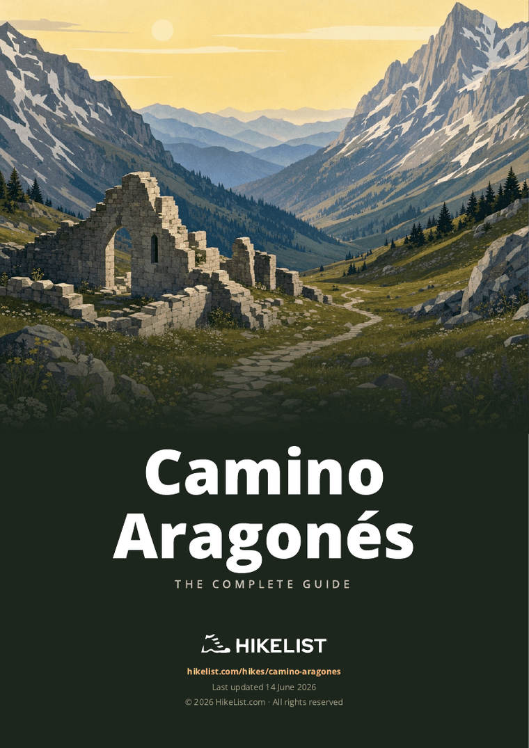
Camino Aragonés
How would you rate Camino Aragonés?
Tap a star to share your experience and help other hikers.
Camino Aragonés: Somport to Puente la Reina Guide
HikeList Score
Camino Aragonés scored 88/100 on HikeList's trail-quality metrics.
See score breakdownHide breakdown
- Ideal length 93
- Balanced challenge 100
- Scenery & wildness 88
- Varied terrain 100
- Accommodation 75
- Food & support 65
- Path quality 92
- Season flexibility 89
Computed from length, challenge, scenery & wildness, terrain variety, accommodation, food & support, path quality and season flexibility.
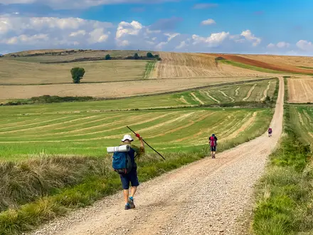
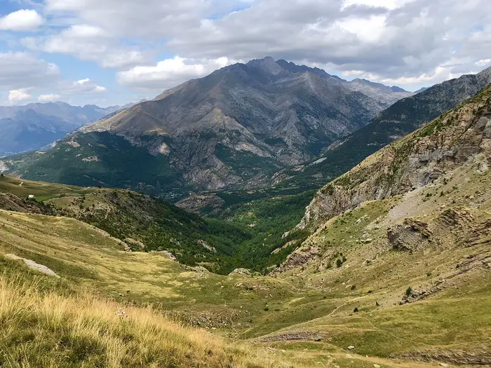
The Camino Aragonés is a 170 km waymarked Camino route in northern Spain, crossing from the Somport pass on the France–Spain border to Puente la Reina in Navarre. Most hikers walk it in 6 days. It is moderate: mountain terrain, a demanding first descent, but no technical sections. It suits walkers who want a quieter Pyrenean approach to the Camino Francés, with albergues and historic towns but fewer beds than the main route.
Route Overview
This is a point-to-point walk from Somport pass, at 1,632 m, to Puente la Reina, where the route merges with the Camino Francés. The usual walking itinerary is Somport to Jaca, Jaca to Arrés, Arrés to Ruesta, Ruesta to Sangüesa, Sangüesa to Monreal, then Monreal to Puente la Reina. In order, key places include Canfranc-Estación, Villanúa, Santa Cilia, Puente la Reina de Jaca, Undués de Lerda and Sangüesa. The route follows the Aragón River valley after the initial Pyrenean descent. As a point-to-point walk, plan separate access to Somport and onward travel from Puente la Reina. For other Spanish Camino options, compare the Camino del Norte guide and Camino Primitivo guide.
A Pyrenean Camino with medieval roots
The Camino Aragonés grew in importance from the 11th century, supported by the early kings of Aragón and by the Hospital de Santa Cristina below the Somport pass. It is the Spanish leg of the Via Tolosana, also known as the Arles route or GR-653, one of the four great medieval roads to Santiago listed in the 12th-century Codex Calixtinus. Pilgrims crossed the central Pyrenees here before joining the main Camino Francés at Puente la Reina.
Notable highlights
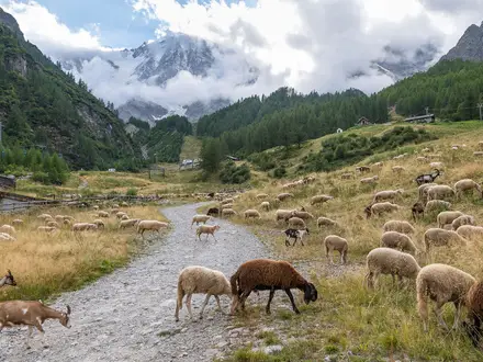
Somport pass and Hospital de Santa Cristina: The route starts at the 1,632 m Somport pass on the France–Spain border. Just below it are the ruins of the medieval Hospital de Santa Cristina de Somport, named in the Codex Calixtinus as one of the three great pilgrim hospitals of Christendom.
Canfranc-Estación: This immense Beaux-Arts international railway station opened in 1928 and was once among the largest in Europe. Restored as a hotel, it is a striking early landmark on the descent from Somport.
Jaca and its cathedral: Jaca was an early capital of the Kingdom of Aragón. Its 11th-century cathedral is one of the earliest Romanesque cathedrals in Spain and a major cultural stop on the route.
Monastery of San Juan de la Peña: This popular off-route detour near Jaca visits a monastery set beneath an overhanging rock cliff. It is associated with early Aragonese kings and Holy Grail legend.
Ruesta: Ruesta is a largely abandoned village clustered around a ruined castle. Its pilgrim albergue is set within the old fortress, giving this stage a distinctive semi-ghost-town feel.
Sangüesa: Sangüesa is a historic Navarrese town known for Romanesque and Gothic churches. The richly carved portal of Santa María la Real is the key architectural stop.
Challenges to expect
Expect a demanding first day: the hardest section is usually the steep descent from Somport to Canfranc-Estación, dropping over 400 m in the first 7 km. Surfaces vary between mountain and forest trails, single-track, farm tracks, meadow paths and quiet roads. Avoid winter and snow shoulder seasons, when the Somport pass can have heavy snow and avalanche risk. Albergues exist along the route, but there are fewer beds than on the busy Camino Francés.
HikeList Score
Camino Aragonés scored 88/100 on HikeList's trail-quality metrics.
See score breakdownHide breakdown
- Ideal length 93
- Balanced challenge 100
- Scenery & wildness 88
- Varied terrain 100
- Accommodation 75
- Food & support 65
- Path quality 92
- Season flexibility 89
Computed from length, challenge, scenery & wildness, terrain variety, accommodation, food & support, path quality and season flexibility.
Show more data Show less
- Mountainous
- Forest
- River Valley
- Meadow
- Single Track
- Farm Tracks
- Meadow Paths
- Quiet Roads
- Country Lanes
- Albergues
- Hostels
- Rural Accommodation
- Family Friendly
- Pet Friendly
- Restrooms
- Water Sources
- Shelters
Download Our Full Guide to Camino Aragonés FREE!
Get our comprehensive guide to this hike for free. Save it for later reading or print out at home.
Articles related to this hike
In these collections
Photos from hikers
Taken on the trail by people who've reviewed Camino Aragonés.
Camino Aragonés: The Complete Guide
 i
Image by miquelrc
i
Image by miquelrc The Camino Aragonés is the quieter Pyrenean approach to Santiago: a 170 km waymarked route from Somport (Puerto de Somport) on the France–Spain border to Puente la Reina (Gares) in Navarre. It suits walkers who want a real Camino with mountain air, Romanesque towns and fewer crowds than the Camino Francés.
The route starts high, at 1,632 m, beside the ruins of the medieval Hospital de Santa Cristina de Somport. From there it drops through the upper Aragón valley via Canfranc-Estación, Villanúa and Jaca before opening into drier foothills and farmland.
Beyond Jaca, the walking becomes more rural and spacious, passing Arrés, Artieda, Ruesta and the shore of the Embalse de Yesa before reaching Sangüesa (Zangoza). The final stages cross Navarre through Monreal (Elo), Obanos and into Puente la Reina, where the Aragonés formally joins the Camino Francés.
This is not a technical trail, but it is not a soft option. The first day has a long descent from the pass to Jaca, several stages run to 27–32 km, accommodation is thinner than on the Francés, and summer heat or snow-season conditions at Somport can change the difficulty sharply.
This guide covers stages, days, accommodation, food, transport, terrain and the common planning mistakes on the Camino Aragonés.
Stage-by-Stage Guide
Stage 1: Somport to Jaca — 32 km
The opening stage is the longest and most demanding day of the Camino Aragonés, not because of technical ground but because it begins at 1,632 m and immediately drops out of the Pyrenees. The route starts at Somport (Puerto de Somport), beside the ruins of the Hospital de Santa Cristina de Somport, then descends towards Canfranc-Estación and the upper Río Aragón valley.
The first section is the key physical test: over 400 m of descent in roughly the first 7 km to Canfranc-Estación. Expect mountain and forest paths, then a gradual transition to valley tracks, meadow paths, lanes and stretches close to minor roads as the route continues through Canfranc (Canfranc-Pueblo), Villanúa and Castiello de Jaca before reaching Jaca.
Canfranc-Estación is the main landmark early in the day, with its enormous restored 1928 international railway station. Jaca is the cultural reward at the end of the stage, with its 11th-century cathedral and Romanesque heritage.
Food and water planning should be conservative on this stage. Canfranc-Estación, Canfranc-Pueblo, Villanúa, Castiello de Jaca and Jaca are the named settlements on the line, but opening hours can vary, especially outside the main season. Carry enough water and food from the start to cover the mountain descent and any closed services.
Jaca is one of the best accommodation bases on the route, with pilgrim and private options compared with the smaller villages ahead. It is also the best place to reset kit, buy food and deal with any blister or knee issues caused by the long descent.
Transport access is strongest at Canfranc-Estación and Jaca. Canfranc has rail access with services from Zaragoza, while limited bus services connect Jaca and the Somport area; current times should be checked before travelling, as mountain services are sparse.
Navigation is generally straightforward, using the GR 65.3 markings, Camino yellow arrows and scallop-shell signs. In poor weather, snow patches or low cloud near Somport can make the opening kilometres more serious; winter and snow-shoulder-season conditions should be avoided because the pass can hold heavy snow and carry avalanche risk.
Stage 2: Jaca to Arrés — 25 km
This stage leaves the larger town of Jaca and moves into quieter foothill country. It is shorter than the first day, but the feel changes quickly: fewer services, more open ground and a stronger need to think ahead about food, water and the night’s bed.
The route passes through or near Santa Cilia (Santa Cilia de Jaca) and Puente la Reina de Jaca before climbing or rising into the small village of Arrés. Underfoot, expect a mix of country lanes, farm tracks, paths through open farmland and sections influenced by the Río Aragón valley.
Views broaden after Jaca, with the Pyrenean backdrop gradually giving way to lower Aragón countryside. This is also the stage where many walkers consider the off-route detour to the Monastery of San Juan de la Peña, but it is not on the main waymarked Camino; allow an extra day if adding it rather than trying to force it into a standard six-day schedule.
Jaca is the place to leave with supplies. Santa Cilia and Puente la Reina de Jaca are the main intermediate settlements, but food and water availability should be checked before relying on them, particularly outside peak season.
Arrés has very limited accommodation compared with Jaca. Plan this night in advance, especially if walking in a busier period or outside the normal albergue season when smaller pilgrim facilities may not be open.
Road access exists through the villages and around Puente la Reina de Jaca, but this should not be treated as a stage with frequent public transport escape options. Rural transport should be checked before travelling.
Navigation remains uncomplicated in normal conditions, but pay attention when leaving towns and where tracks, lanes and farm access routes intersect. In hot weather, the more open foothill sections can feel exposed, so an early start is sensible.
Stage 3: Arrés to Ruesta — 28 km
Arrés to Ruesta is one of the most rural and logistically important stages of the Camino Aragonés. The distance is significant, the settlements are small, and the route crosses exposed cereal country before reaching the distinctive, largely abandoned village of Ruesta.
The stage passes Martes and Artieda and then continues towards the shore of the Embalse de Yesa. Terrain is generally non-technical: farm tracks, quiet lanes, open paths, scrubby sections and reservoir-side country, with little shelter in places.
The Yesa reservoir is the defining landscape feature of the day. The walking can be scenic, but it is also one of the sections where sun, wind and lack of shade matter more than gradient.
Food and water need careful planning. Arrés, Martes, Artieda and Ruesta are all small places, and services should not be assumed to be open. Start the day carrying enough to reach Ruesta if intermediate options are closed.
Ruesta has a unique atmosphere, with its largely abandoned village, ruined castle and pilgrim albergue set within the old fortress area. Accommodation is limited, so this is a stage end where advance planning is especially important.
Road access is present in the wider area, but public transport is not something to rely on casually here. If using baggage transfer, taxis or any support arrangement, confirm arrangements before starting the stage.
Navigation is usually clear, but the openness of the landscape means waymarks can be spaced out between settlements. Keep an eye on the GR 65.3 and yellow arrows at junctions, especially where agricultural tracks branch away.
Stage 4: Ruesta to Sangüesa (Zangoza) — 22 km
This is the shortest of the standard six stages, but it still deserves a proper early start if the weather is hot. The route leaves Ruesta’s semi-abandoned setting and continues west towards Navarre, finishing in the historic town of Sangüesa (Zangoza) on the Río Aragón.
The main named settlement on the way is Undués de Lerda. The walking is a continuation of rural tracks, lanes and open country, with the terrain gradually moving away from the reservoir landscape towards the river valleys of Navarre.
The stage highlight is the change in character on arrival in Sangüesa. After several quieter nights, the town feels more substantial and is known for the richly carved Romanesque portal of the church of Santa María la Real.
Carry food and water from Ruesta unless certain of intermediate services. Undués de Lerda is the only named village between the two stage ends, and small-village opening hours can be unreliable for a walker’s schedule.
Sangüesa is one of the better accommodation and service stops on the Camino Aragonés. It is a practical place to restock, book ahead for the following smaller stage end and review weather conditions for the exposed farmland stages still to come.
Road access improves on reaching Sangüesa, but onward public transport options and timings should be checked before travelling. Do not assume rural bus frequency will match a walking itinerary.
Navigation is straightforward in normal conditions, but the route includes the usual mix of paths, tracks and minor roads. Take extra care on any road-side or lane sections and at junctions leaving Ruesta and entering Sangüesa.
Stage 5: Sangüesa (Zangoza) to Monreal (Elo) — 27 km
This stage links Sangüesa with Monreal (Elo), moving deeper into Navarre through rolling farmland and river-valley country. It is a full-distance walking day rather than a recovery stage, so use Sangüesa to stock up properly before leaving.
The route passes near Lumbier and through Izco before reaching Monreal. Expect a varied but non-technical mix of farm tracks, rural paths, lanes and open sections where heat and wind can be more important than steepness.
The scenery is quieter and less dramatic than the Pyrenean start, but the walking has a steady rhythm through agricultural Navarre. Views open across fields and low ridges rather than high mountains.
Food and water should be managed carefully between Sangüesa and Monreal. Lumbier is near the route and Izco is the main named place on the line, but exact service availability should be checked before relying on either for a meal or resupply.
Monreal is a smaller stage end than Sangüesa, so accommodation should be planned ahead. This is particularly important outside the main walking season, when some albergues and small rural places may close.
Road access exists around the settlements, but practical public transport for joining or leaving the route should be checked before travelling. Sangüesa is the safer place to make larger logistical adjustments before committing to the stage.
Waymarking continues with GR 65.3 and Camino arrows. The main navigation risks are routine ones: missing a turn on rural tracks, following a farm access route by mistake, or losing concentration late in the day after several hours of exposed walking.
Stage 6: Monreal (Elo) to Puente la Reina (Gares) — 31 km
The final stage is long and should not be underestimated. It crosses rolling Navarrese farmland and river-valley terrain before joining the Camino Francés and finishing at Puente la Reina (Gares).
The route passes Yárnoz, near Tiebas, then continues through Enériz and Obanos before reaching Puente la Reina. Santa María de Eunate, the octagonal Romanesque church near Enériz, is a worthwhile short detour off the marked route, not part of the direct line.
The key Camino moment comes at Obanos, where the Camino Aragonés meets the Roncesvalles branch of the Camino Francés. The merge is marked by the pilgrim monument with the line that from here all roads to Santiago become one.
Terrain remains moderate rather than technical: tracks, paths, minor lanes and open agricultural sections. The main challenge is the 31 km distance, especially in summer heat or if starting tired after five consecutive stages.
Carry enough food and water from Monreal to avoid depending completely on intermediate stops. Yárnoz, Tiebas, Enériz and Obanos provide named points along the way, but exact services and opening times should be checked before travelling.
Puente la Reina is a major Camino town compared with many earlier stops, with a wider mix of pilgrim albergues and other accommodation. It is also the practical transport finish, with buses to Pamplona, where there are onward rail and air connections.
Navigation is usually simple, but the final day includes more route choice pressure around villages, road crossings and the optional Eunate detour. If visiting Eunate, allow extra time and make sure the return to the main Camino is clear before continuing to Obanos and Puente la Reina.
Recommended Itinerary
Standard 6-day itinerary
The standard Camino Aragonés itinerary is six walking days from Somport (Puerto de Somport) to Puente la Reina (Gares). It is a logical schedule because it uses the established stage towns, keeps the mountain descent to one day, and finishes each night in places normally used by pilgrims on this route.
Distances are approximate. Accommodation is more limited than on the Camino Francés, especially in smaller villages such as Arrés and Ruesta, so do not treat this as a route where every stage can be improvised safely out of season.
| Day | From | To | Approx. distance | Why this stage makes sense | Services/accommodation notes |
|---|---|---|---|---|---|
| 1 | Somport (Puerto de Somport) | Jaca | 32 km | This is the classic opening stage: start at the 1,632 m pass, descend past the Hospital de Santa Cristina ruins and through the Canfranc valley, then continue to the first major town. It is long and mostly downhill early on, with a steep initial descent to Canfranc-Estación, so it is harder on knees than the profile may suggest. | Jaca is one of the best-served towns on the route, with a wider choice of pilgrim and private accommodation than the smaller villages. Start early from Somport, especially in summer heat or if arriving by limited mountain transport. |
| 2 | Jaca | Arrés | 25 km | A shorter day after the demanding opener, moving from the Pyrenean valley towards the quieter foothill section. It keeps the itinerary balanced before the more exposed country around the Yesa reservoir. | Arrés has very limited options compared with Jaca. Accommodation should be planned ahead, particularly outside the main walking season. |
| 3 | Arrés | Ruesta | 28 km | This stage carries you through the rural middle section of the route, passing places such as Martes and Artieda and skirting the Embalse de Yesa. It is a proper full day and can feel exposed in warm weather. | Ruesta is a distinctive but small overnight stop, with limited pilgrim infrastructure. Do not rely on turning up late without a bed plan. |
| 4 | Ruesta | Sangüesa (Zangoza) | 22 km | The shortest standard stage gives useful recovery after the longer rural days and brings the route into Navarre. It is a sensible place to regain supplies and sleep in a larger town. | Sangüesa (Zangoza) has more services than the preceding villages and is a practical resupply and laundry stop. It is also a good place to reset the plan before the final two longer stages. |
| 5 | Sangüesa (Zangoza) | Monreal (Elo) | 27 km | A steady inland stage through the Navarrese section, passing near Lumbier and through Izco before reaching Monreal. It positions walkers well for the final push to Puente la Reina. | Monreal is a smaller stop than Sangüesa, so accommodation availability should be checked before travelling. Carry enough food and water for the day rather than assuming frequent services. |
| 6 | Monreal (Elo) | Puente la Reina (Gares) | 31 km | A long final stage through rolling farmland and villages including Yárnoz, Tiebas area, Enériz and Obanos, where the Camino Aragonés meets the Camino Francés. The day ends at Puente la Reina (Gares), the natural finish for this route. | Puente la Reina (Gares) is a larger Camino town with onward buses to Pamplona. The church of Santa María de Eunate is a worthwhile short detour near Enériz, but it is off the marked line and adds time to an already long day. |
Slower options
A 7-day schedule suits walkers who dislike 30 km days, anyone starting late from Somport, and those who want more margin for heat, weather or accommodation constraints. The most useful place to add time is the opening stage: split Somport–Jaca by stopping somewhere in the Canfranc valley, such as Canfranc-Estación, Canfranc, Villanúa or Castiello de Jaca. Exact accommodation availability should be checked before booking.
Another common way to slow the route is to keep the six walking stages but add an extra day near Jaca for the Monastery of San Juan de la Peña. This monastery is a popular off-route detour, not part of the main waymarked Camino Aragonés, so it should be planned as an extension rather than squeezed into a normal stage.
The final Monreal–Puente la Reina stage is also long at about 31 km. Splitting it may be possible only if suitable accommodation or transport is arranged around the intermediate settlements; this should be checked before travelling.
Faster option
A faster itinerary is not recommended for most walkers. The standard six-day schedule already includes stages of roughly 27–32 km and the first day begins with a high Pyrenean descent from Somport.
Very strong walkers travelling light could complete the route in fewer days only by combining already long stages or by using non-standard overnight stops. That approach leaves little margin for heat, limited services or full albergues, so official mapping and accommodation should be checked before booking.
Planning the Route
The Camino Aragonés is best planned around accommodation and transport first, then daily mileage. The waymarking is straightforward in normal conditions, but the route is quieter than the Camino Francés and has fewer beds, fewer fallback services and several long days where changing plan mid-stage is not always simple.
Most walkers should allow the standard 6 walking days from Somport (Puerto de Somport) to Puente la Reina (Gares). Add at least one extra day if including the Monastery of San Juan de la Peña, which is a popular detour from the Jaca area but not on the main waymarked route.
How many days to allow
Six days is the normal itinerary, but it is not a leisurely schedule. The first day from Somport to Jaca is long and starts with a substantial mountain descent, while several later stages sit in the 27–32 km range.
A slower 7-day or 8-day plan is more comfortable for walkers who prefer shorter days, want time in Jaca or Sangüesa (Zangoza), or are starting the Camino without recent long-distance walking fitness. Splitting stages is possible in principle, but it depends on current accommodation in intermediate villages and should be checked before travelling.
A faster schedule is only sensible for strong walkers who are comfortable with repeated long days and minimal margin. Compressing the route reduces flexibility in the quieter sections around Arrés, Ruesta and the Yesa reservoir, where accommodation and services are more limited.
Standard stage structure
The route is naturally shaped by the main overnight stops. These are not just convenient distances: they reflect where pilgrim accommodation is commonly used along a rural route with fewer beds than the Camino Francés.
| Stage | Usual section | Planning notes |
|---|---|---|
| 1 | Somport to Jaca — approx. 32 km | The hardest planning day: mountain start, steep descent to Canfranc-Estación, then a long continuation through the Aragón valley. Start early and avoid arriving at Somport late in the day. |
| 2 | Jaca to Arrés — approx. 25 km | Shorter on paper, but accommodation at Arrés is limited, so this stage should not be left to chance in busy periods or out of peak season. |
| 3 | Arrés to Ruesta — approx. 28 km | Rural, exposed country near the Embalse de Yesa. Carry food and enough water for the day rather than relying on frequent services. |
| 4 | Ruesta to Sangüesa (Zangoza) — approx. 22 km | The shortest standard day, ending in a larger Navarrese town with more services than the preceding rural stops. |
| 5 | Sangüesa (Zangoza) to Monreal (Elo) — approx. 27 km | A longer inland stage where an early start helps in warm weather. Check accommodation arrangements before committing to the day. |
| 6 | Monreal (Elo) to Puente la Reina (Gares) — approx. 31 km | A long final day through rolling Navarrese country, joining the Camino Francés near Obanos before Puente la Reina. The church of Santa María de Eunate is a worthwhile short detour near Enériz, but it is off the marked line. |
Booking and flexibility
Accommodation planning matters more here than on the Camino Francés. Pilgrim albergues, donativo beds, rural guesthouses and small hotels exist along the route, but capacity is uneven and some villages have very limited options, notably Arrés and Ruesta.
Book or at least check ahead whenever walking outside the main season, when some albergues may close. This is especially important if relying on municipal, parish or donativo accommodation, where opening arrangements can change.
The larger towns — especially Jaca, Sangüesa (Zangoza) and Puente la Reina (Gares) — give the best flexibility for accommodation, food and rest. Between them, the route is more rural, so avoid assuming that every village will have a shop, bar or spare bed available on arrival.
Shortening, extending and detours
Shortening individual days is possible only where there is a practical overnight stop between the standard stage ends. Intermediate places such as Canfranc-Estación, Canfranc (Canfranc-Pueblo), Villanúa, Castiello de Jaca, Santa Cilia, Puente la Reina de Jaca, Artieda, Undués de Lerda, Izco and other villages lie on or near the line, but current accommodation and opening dates should be checked before building an itinerary around them.
The most significant extension is the detour to the Monastery of San Juan de la Peña near Jaca. Allow an extra day rather than trying to fold it into an already long stage unless the itinerary has been deliberately planned around it.
Santa María de Eunate, near Enériz on the final stage, is also off the marked route. It is a shorter detour than San Juan de la Peña, but it still adds time to a long Monreal–Puente la Reina day.
Section hiking
Section hiking is practical, but access is uneven. The easiest points to use are those with stronger transport links: Canfranc has a railway station with services from Zaragoza, Jaca is the key town below Somport, and Puente la Reina has bus connections to Pamplona.
Intermediate rural sections are less convenient to enter or leave without pre-arranged transport. Mountain and rural bus services are sparse, and current timetables should be checked before travelling.
For a shorter taste of the route, the Pyrenean opening from Somport through Canfranc-Estación to Jaca gives the strongest mountain character. For a more rural Camino section, the stages around Arrés, Ruesta and Sangüesa follow the quieter Aragón valley and Yesa reservoir country, but require more careful accommodation planning.
Food, water and daily logistics
Carry lunch and sufficient water for each stage, particularly across the more exposed foothill and reservoir sections. Summer heat can make the open country between Arrés, Ruesta and Sangüesa feel more demanding than the gradients suggest.
Use larger towns such as Jaca and Sangüesa (Zangoza) for more reliable resupply. In smaller villages, services may be limited, seasonal or closed at the time of day walkers pass through.
Start early on the longest stages. This is most important on day 1 from Somport, where the descent is steep and the total distance to Jaca is substantial, and on the exposed valley stages in warm weather.
Navigation and weather planning
In normal conditions, navigation is one of the easier parts of the route. Follow the GR 65.3 markings together with Camino yellow arrows and scallop-shell markers.
Winter and the snow shoulder seasons are different. The Somport pass can hold heavy snow and carries avalanche risk roughly from November to May, and waymarking is harder to follow when covered. Avoid planning this route in winter unless current mountain conditions and accommodation openings have been checked carefully.
Late spring to early autumn is the most practical walking window. Even then, the route begins at 1,632 m on the France–Spain border, so pack for mountain conditions at the start as well as heat and sun exposure lower down the Aragón and Navarre valleys.
Transport planning
Transport to the start is a key constraint. Somport is reached by limited or seasonal bus services from Jaca and from Oloron-Sainte-Marie on the French side, while Canfranc below the pass has a railway station with services from Zaragoza. Current bus and train times should be checked before travelling.
At the finish, Puente la Reina (Gares) has buses to Pamplona, which has onward rail and air connections. Do not assume late services will line up neatly with a long final walking day; check times before fixing accommodation or onward tickets.
Towns, Villages and Overnight Stops
Accommodation on the Camino Aragonés is more limited than on the Camino Francés, so the overnight strategy matters. The standard six-stage pattern uses Jaca, Arrés, Ruesta, Sangüesa (Zangoza), Monreal (Elo) and Puente la Reina (Gares) as the main stops, with pilgrim albergues forming the backbone and hotels, hostels and casas rurales filling the gaps in larger places.
Do not treat every village as a reliable resupply point. Several settlements are small, and some albergues are seasonal, donativo or have very limited capacity. Opening dates, meal availability and reservation rules should be checked before travelling, especially outside the main spring-to-autumn Camino season.
Somport (Puerto de Somport)
Somport is the high mountain start of the route, at 1,632 m on the France–Spain border. It is a practical start point rather than a normal overnight stop, and most walkers either arrive by limited mountain transport or start after staying lower down in the valley.
Public transport is a key planning issue here. There are limited or seasonal bus services from Jaca and from Oloron-Sainte-Marie on the French side, and current times should be checked before travelling.
Do not assume food, shop or accommodation availability at the pass itself. Start with water and food for the descent, and allow for mountain weather even in the walking season.
Hospital de Santa Cristina de Somport
The ruins of the medieval Hospital de Santa Cristina de Somport sit just below the pass at the beginning of the waymarked GR 65.3 route. This is an important historic landmark, not an overnight or service stop.
There are no planning advantages to stopping here beyond a short visit at the start of the walk. Continue prepared for the descent towards Canfranc-Estación, as services should not be assumed around the ruins.
Canfranc-Estación
Canfranc-Estación is reached early on the first stage after the steep descent from Somport. It is one of the most useful practical places on the upper route because Canfranc has a railway station with services from Zaragoza.
This is a sensible fallback start point if transport to Somport is difficult or if conditions at the pass are unsuitable. It can also work as a short first-night stop for walkers who do not want to combine the high descent with the full stage to Jaca.
Accommodation and food options should be checked before relying on them, but Canfranc-Estación is more useful than the smaller settlements immediately above and below it. The restored international railway station, now a hotel, is also one of the route’s major landmarks.
Canfranc (Canfranc-Pueblo)
Canfranc-Pueblo lies below Canfranc-Estación on the first day’s descent towards Jaca. It is mainly useful as an intermediate point for pacing the long first stage.
It may suit walkers splitting the Somport–Jaca day, but bed availability should be checked before planning around it. Do not assume a full range of food shops or evening meals without checking current local services.
Villanúa
Villanúa is another intermediate settlement on the first stage between Somport and Jaca. It is useful as a rest, food or possible overnight point only if current services line up with the day’s plan.
For most walkers following the six-stage itinerary, Villanúa is passed through rather than used as a stage end. Anyone shortening the first day should check accommodation and food in advance rather than arriving speculatively.
Castiello de Jaca
Castiello de Jaca sits on the approach to Jaca, still within the long first stage from Somport. It can be useful as a final break before reaching the day’s main stop.
As with the other valley villages on day one, it is not the standard overnight target. Treat any accommodation, café or shop plans here as something to verify before travel, particularly if walking outside peak season.
Jaca
Jaca is the main service centre of the first half of the Camino Aragonés and the standard overnight stop after the opening stage from Somport. It is the best place early on the route to reset after the mountain descent, organise food, and deal with any kit or transport issues.
Accommodation choice is broader here than in the smaller villages, with the route’s usual mix of pilgrim beds supplemented by hostels, casas rurales and hotels. Booking ahead is still sensible in busy periods and when arriving after a long stage.
Jaca is also a practical transport base because Somport bus access is linked to Jaca. The town is worth allowing time for if visiting the cathedral or planning the off-route detour to the Monastery of San Juan de la Peña, which normally requires adding time rather than treating it as part of the main waymarked day.
Santa Cilia (Santa Cilia de Jaca)
Santa Cilia lies west of Jaca on the second stage towards Arrés. It is useful as an intermediate settlement after leaving the larger services of Jaca behind.
It is not the standard stage end on the six-day schedule, but it may help walkers who want to divide the Jaca–Arrés stage more gently. Accommodation, meals and shops should be checked before making it an overnight plan.
Puente la Reina de Jaca
Puente la Reina de Jaca is on the route between Santa Cilia and Arrés. Be careful not to confuse it with Puente la Reina (Gares), the finish of the Camino Aragonés in Navarre.
For most walkers this is a through-point rather than an overnight stop. It can be useful for food or a rest if services are open, but this should be checked before travelling.
Arrés
Arrés is the standard overnight stop at the end of day two. It is one of the places where planning matters most, because accommodation is very limited compared with larger towns.
Do not arrive assuming spare beds, food or flexible opening hours. Reserve where possible, check the current status of the pilgrim accommodation, and carry enough food and water to cover a thin-service evening if necessary.
Arrés is still a logical stop because it fits the established stage pattern between Jaca and Ruesta. The main practical issue is capacity, not route position.
Martes
Martes lies between Arrés and Artieda on the third stage towards Ruesta. It is a small intermediate settlement rather than a main overnight hub.
Use it for pacing the day, not as a guaranteed resupply or accommodation point. Any plan to stop here should be checked before travelling.
Artieda
Artieda sits on the Arrés–Ruesta stage, in the open country before the route approaches the Yesa reservoir area. It can be a useful intermediate point on what is otherwise a fairly committed day.
It is not the standard overnight stop in the six-day itinerary, but it may be relevant for walkers adjusting stage lengths. Accommodation and meal availability should be checked in advance, especially outside the main walking season.
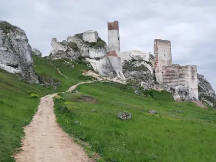
Ruesta
Ruesta is the standard overnight stop at the end of day three and one of the most distinctive places on the route. It is a largely abandoned village around a ruined castle, with the pilgrim albergue set within the old fortress setting.
This is not a place to treat casually. Options are limited, so check the albergue opening, reservation position and food arrangements before committing to the Arrés–Ruesta stage.
The stage into Ruesta includes the exposed country around the Embalse de Yesa, so arrive with enough water and food margin. If the accommodation at Ruesta is closed or full, alternatives may not be close or convenient on foot.
Undués de Lerda
Undués de Lerda is between Ruesta and Sangüesa (Zangoza) on the fourth stage. It is a useful intermediate village after leaving the very limited services of Ruesta.
For most walkers it is a daytime stop rather than an overnight target. Food, café and accommodation availability should be checked before depending on it.
Sangüesa (Zangoza)
Sangüesa (Zangoza) is the standard overnight stop at the end of day four and one of the main towns on the route. It sits on the Río Aragón and has a broader accommodation base than the small villages, including the general Camino mix of pilgrim lodging and private options.
This is a good place to resupply, eat properly and prepare for the next long stage to Monreal (Elo). It is also a worthwhile cultural stop, especially for the Romanesque portal of Santa María la Real.
Any onward local transport should be checked before relying on it. As a route-planning point, Sangüesa is the best service stop between Ruesta and Monreal.
Lumbier (near)
Lumbier is near the route corridor on the Sangüesa–Monreal section, but it is not listed as a standard stage end on the six-day itinerary. It may be relevant for walkers adapting the day or looking for services off the direct line.
Because it is described as near rather than a core on-route stop, check the exact route variant, access, accommodation and food before building a stage around it. Do not assume it will fall naturally on the waymarked line.
Izco
Izco lies on the fifth stage between Sangüesa (Zangoza) and Monreal (Elo). It is mainly a pacing point on a long day rather than a primary overnight stop.
Services should be treated as limited unless checked in advance. Carry food and water from Sangüesa if relying on the standard stage to Monreal.
Monreal (Elo)
Monreal (Elo) is the standard overnight stop at the end of day five and the last main stop before the long final stage to Puente la Reina (Gares). Its position makes it important even though it is not one of the larger towns named for broad accommodation choice.
Check bed availability and food arrangements before arrival, particularly outside peak season. This is a key place to avoid an accommodation problem because the following day is already long.
Monreal is also the point to organise an early start for the final stage, which passes several smaller settlements before reaching Obanos and Puente la Reina. Do not leave resupply planning until the morning unless current local shop or café opening has been checked.
Yárnoz
Yárnoz is an intermediate village on the final stage from Monreal (Elo) to Puente la Reina (Gares). It is useful for navigation and pacing, but not a main overnight target.
Treat services as uncertain unless checked before travelling. The final day is long enough that walkers should leave Monreal prepared to continue through small villages without guaranteed resupply.
Tiebas (near)
Tiebas is near the final-stage line between Monreal and Enériz. It is not presented as a standard overnight stop, so it is mainly relevant as a nearby settlement or route reference.
If planning to use Tiebas for accommodation, food or transport, check exact access from the waymarked route and current services before travelling. Do not assume it sits directly on the Camino line.
Enériz
Enériz lies late on the final stage before Obanos and Puente la Reina. It is an important planning point because the off-route detour to Santa María de Eunate is nearby.
For most walkers, Enériz is a daytime stop rather than the end of the day. Services should be checked before relying on them, especially if taking time for the Eunate detour and arriving later than planned at Puente la Reina.
Santa María de Eunate (off route)
Santa María de Eunate is a short detour off the marked route near Enériz, not a main-line overnight stop. It is best treated as a visit to an exceptional Romanesque church rather than as a service point.
Allow time and energy for the detour on the final stage. Check current access and opening arrangements before planning around a visit, and do not rely on food or accommodation at the church itself.
Obanos
Obanos is where the Camino Aragonés formally meets the Roncesvalles branch of the Camino Francés shortly before Puente la Reina. The pilgrim monument marks the merge with the inscription that from here all the roads to Santiago become one.
Most walkers continue to Puente la Reina rather than stopping at Obanos, because the formal finish is close beyond. It is still an important navigation and route-transition point, especially as the Camino becomes busier after joining the Francés.
Accommodation and food may be possible in the area, but current services should be checked before treating Obanos as an overnight alternative to Puente la Reina.
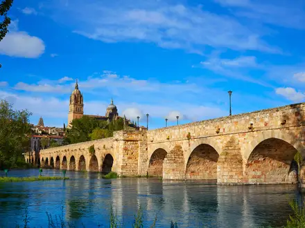
Puente la Reina (Gares)
Puente la Reina (Gares) is the finish of the Camino Aragonés and the first major shared stop after joining the Camino Francés. It is the most practical end point for accommodation, onward transport and continuing west towards Santiago.
Accommodation choice is broader here than in the small Aragonés villages, with hotels and other private options supplementing pilgrim lodging. Demand can be higher because the route has now merged with the Camino Francés, so booking ahead is sensible in busy periods.
For transport, Puente la Reina has bus links to Pamplona. Pamplona has a railway station and an airport with onward national connections, but current bus times should be checked before travelling.
Getting to the Start
The Camino Aragonés starts at Somport (Puerto de Somport), the 1,632 m road pass on the France–Spain border. The practical access points are Canfranc-Estación and Jaca on the Spanish side, or Oloron-Sainte-Marie on the French side, with the final link to the pass by limited bus or taxi.
By train
The nearest railway station to the start is at Canfranc-Estación, below the pass and early on the first walking stage. Canfranc has rail services from Zaragoza, making Zaragoza the main rail gateway for walkers approaching from elsewhere in Spain.
From Canfranc-Estación, the route start at Somport is still uphill at the border pass. Use the limited bus connection where available, or arrange a taxi to the pass rather than adding an unplanned climb before the first long stage to Jaca. Timetables and taxi availability should be checked before travelling.
By bus
Buses are the key final link to Somport. Services run from Jaca towards the pass, but they are limited and may be seasonal, so do not assume a same-day connection without checking the current timetable.
There are also limited services from Oloron-Sainte-Marie on the French side of the Pyrenees. This can work well for walkers approaching via France or continuing from the Via Tolosana/GR 653, but mountain border services are sparse. This should be checked before travelling.
If bus times do not line up with your arrival, a pre-booked taxi from Jaca or Canfranc-Estación is the most practical fall-back. This is especially important if arriving late in the day, as the first stage from Somport to Jaca is long and begins with a steep descent.
By car
Driving to Somport is possible, but it is usually awkward for a point-to-point Camino. The walk finishes at Puente la Reina (Gares), not back at the pass, so leaving a vehicle at the start creates a long return journey at the end.
If travelling by car, the simplest arrangement is often to be dropped at Somport, or to leave the vehicle in a larger service town such as Jaca and use bus or taxi transport up to the pass. Long-stay parking arrangements, restrictions and security should be checked locally before committing to this plan.
Do not rely on finding suitable long-stay parking at the pass itself. This should be checked before travelling.
From the nearest airport
There is no airport at the start of the route. The practical approach is to fly into a city with onward rail or bus links, then connect to Zaragoza, Jaca or Canfranc-Estación before making the final journey to Somport by bus or taxi.
For walkers planning the whole route, remember that the finish at Puente la Reina (Gares) has bus links to Pamplona, which has a railway station and an airport with onward national connections. This makes it worth planning both ends together rather than treating the start in isolation.
Where to stay before starting
Starting from Somport and walking to Jaca is a demanding first day of about 32 km, with a steep Pyrenean descent to Canfranc-Estación early on. Arriving at the pass late in the morning or afternoon is a poor plan unless you are shortening the stage.
For most walkers, the sensible options are to stay the night before in Jaca, Canfranc-Estación or another settlement below the pass, then take an early bus or taxi to Somport. This gives a clean start from the official trailhead and avoids trying to combine long-distance travel with the first full stage.
Accommodation is more limited in the mountain villages than in larger towns, and services on this route are thinner than on the Camino Francés. Book ahead where necessary, especially outside the main season, and check that transport to Somport is running on the day you intend to start.
Getting Home from the Finish
The Camino Aragonés finishes at Puente la Reina (Gares), where most onward travel is routed via Pamplona. Build some slack into the final day: the Monreal to Puente la Reina stage is long, and onward bus connections are timetable-dependent.
By train
Puente la Reina (Gares) is not the rail hub for this finish. The practical rail connection is via Pamplona, which has a railway station with onward national connections.
Plan on taking a bus or taxi from Puente la Reina to Pamplona before joining the rail network. Train times and any required reservations should be checked before travelling, especially if aiming for a same-day long-distance connection.
By bus
There are buses from Puente la Reina to Pamplona. This is usually the simplest public-transport exit from the route, with Pamplona then serving as the main onward hub.
Do not assume late-evening flexibility. Rural and inter-town services can be limited, and current bus times should be checked before travelling. If the final walking day runs long, staying in Puente la Reina is often more sensible than trying to force a same-day connection.
By car/taxi
Puente la Reina is a straightforward place to be collected compared with ending at the Obanos pilgrim monument, where the Camino routes formally merge before town. Arrange a clear pick-up point in Puente la Reina itself rather than relying on meeting on the trail.
Taxis or private transfers to Pamplona may be a practical fallback if bus times do not work, particularly for an early train or flight the next morning. Availability, prices and booking arrangements should be checked locally before relying on this option.
From the nearest airport
Pamplona has an airport with onward national connections, making it the relevant airport for leaving the finish. The usual sequence is Puente la Reina to Pamplona by bus or taxi, then onward from the city.
Flight schedules and airport transfer arrangements are timetable-dependent. If flying the same day, allow a conservative buffer after the final stage; if the connection is tight, stay overnight either in Puente la Reina or Pamplona.
Where to stay at the finish
Puente la Reina (Gares) has pilgrim accommodation and other town services, and it is a common stopping point because the Camino Aragonés has just joined the Camino Francés. Expect more pilgrim traffic here than on much of the Aragonés route.
Staying overnight at the finish is the safest plan if arriving late, if bus times are sparse, or if onward travel requires a morning train or flight from Pamplona. Book ahead in busy Camino periods, and check opening dates outside the main season.
Which Direction Should You Walk?
The Camino Aragonés is best walked in its traditional westbound direction: Somport (Puerto de Somport) to Puente la Reina (Gares). This follows the pilgrim flow towards Santiago, uses the GR 65.3 / Camino waymarking as intended, and ends where the route merges with the Camino Francés at Obanos and Puente la Reina.
Walking in reverse is possible in practical hiking terms, but it is not the natural direction of the route. It makes the navigation, transport finish and elevation profile less convenient, and it removes much of the Camino logic of the walk.
Standard direction: Somport to Puente la Reina
The main advantage of starting at Somport is that the route begins at its high point: the 1,632 m Somport pass. From there the path descends through the Pyrenean headwaters towards Canfranc-Estación, Canfranc, Villanúa and Jaca, then gradually moves through foothills, reservoir country and the rolling farmland of Navarre.
This does not make the walk easy. The first stage to Jaca is long at about 32 km, and the descent from Somport to Canfranc-Estación drops more than 400 m in the first few kilometres, which can be hard on knees and feet. Even so, westbound walkers avoid turning the route into a cumulative climb back up to the pass.
The scenery also unfolds well in this direction. The route opens with the strongest mountain setting, then widens into the Río Aragón valley, the Yesa reservoir area, Sangüesa (Zangoza), Monreal (Elo), Obanos and finally Puente la Reina. For walkers continuing to Santiago, the finish is not really an ending but a natural handover onto the Camino Francés.
Accommodation planning also fits the standard direction. The usual six-stage itinerary is built around westbound stops at Jaca, Arrés, Ruesta, Sangüesa, Monreal and Puente la Reina. Beds are more limited than on the Camino Francés, especially in smaller places such as Arrés and Ruesta, so the direction does not remove the need to plan ahead — but it does align with the way most pilgrims and services expect the route to be walked.
Reverse direction: Puente la Reina to Somport
Walking eastbound gives a different experience: the Pyrenees become the destination rather than the starting point. The landscape builds gradually from Navarre towards the mountains, with a dramatic final approach to Somport.
The trade-off is effort. In reverse, the route broadly gains altitude, and the final mountain section climbs back towards the pass rather than descending from it. Anyone reversing the standard stages should be prepared for the last day into Somport to feel much tougher than the equivalent westbound opening.
Navigation is also less natural. The route is waymarked as a Camino towards Santiago with yellow arrows and scallop-shell markers, so reverse walkers should not rely on seeing every mark easily from the opposite direction. A reliable map or GPX track is strongly advisable.
Transport is the other drawback. Puente la Reina has onward bus access to Pamplona, with rail and airport connections from there, which makes it a convenient finish in the standard direction. Ending at Somport leaves you dependent on limited mountain transport from the pass or on reaching Canfranc, which has a railway station with services from Zaragoza; current bus and train times should be checked before travelling.
Weather and season
There is no strong direction-based weather advantage for this route. The key seasonal issue is the Somport pass itself: winter and the snow shoulder seasons should be avoided because the pass can hold heavy snow and avalanche risk roughly from November to May.
This affects both directions, but reverse walkers should be especially careful not to leave the highest and most weather-exposed section until the end without checking conditions. In summer, long exposed valley stages make early starts sensible whichever way you walk.
Recommendation
Walk the Camino Aragonés westbound from Somport to Puente la Reina. It is the traditional Camino direction, follows the waymarking naturally, gives the easier overall elevation trend, fits the standard accommodation stages and ends with the satisfying merge into the Camino Francés.
Only choose the reverse direction if there is a specific reason to finish in the Pyrenees and you are comfortable with less convenient transport, more uphill walking and navigation against the usual Camino flow.
Accommodation Along the Route
Accommodation on the Camino Aragonés is usable but requires more planning than the Camino Francés. Pilgrim albergues — municipal, parish and donativo — are the backbone of the route, with small hostels, casas rurales and hotels filling the gaps in larger towns.
The key issue is not luxury but bed supply. Jaca, Sangüesa (Zangoza) and Puente la Reina (Gares) have the strongest choice, while smaller stage stops such as Arrés and Ruesta have very limited options. Do not treat this as a route where it is always safe to arrive late and improvise.
Best overnight strategy
The standard six-stage itinerary uses these overnight stops: Jaca, Arrés, Ruesta, Sangüesa (Zangoza), Monreal (Elo) and Puente la Reina (Gares). This works well if accommodation is open and available, but it leaves little margin on the quieter middle stages.
The first day from Somport to Jaca is long and mostly downhill. Walkers who do not want a full 32 km mountain-to-town day can look at breaking the descent around Canfranc-Estación, Canfranc (Canfranc-Pueblo), Villanúa or Castiello de Jaca, but current availability should be checked before travelling.
The main pinch points are Arrés and Ruesta. Both sit in rural sections where alternatives are limited, so these nights should be planned before committing to the stage. Ruesta is especially distinctive but remote-feeling, with its accommodation tied to the largely abandoned village setting.
Booking ahead and seasonal closures
Booking ahead is strongly recommended for private rooms and sensible for small albergue stages, especially outside the main walking season. Many albergues on this route are seasonal or have variable opening, and winter is a poor time to attempt the route because the Somport pass can hold heavy snow and many pilgrim services close.
In late spring, summer and early autumn, availability is generally more realistic, but long stages still make planning important. If a bed is not available at Arrés, Ruesta or Monreal (Elo), the workaround may require a much longer day, a taxi transfer or a redesigned itinerary. This should be checked before travelling.
Weekend and holiday pressure is most relevant in the larger towns, particularly Jaca, Sangüesa (Zangoza) and Puente la Reina (Gares), where hotels and guesthouses also serve non-pilgrim visitors. If using private accommodation, book these nights in advance rather than relying on arrival-day availability.
Accommodation by place
| Place | Accommodation level | Best for | Notes |
|---|---|---|---|
| Somport (Puerto de Somport) | Limited/uncertain | Starting the route | Most walkers treat the pass as the start point rather than an overnight base. If planning to sleep at or near the pass, this should be checked before travelling. |
| Canfranc-Estación / Canfranc (Canfranc-Pueblo) | Limited to moderate | Shortening the first stage | Useful if the full Somport–Jaca stage is too long. Canfranc-Estación has the restored international station now operating as a hotel, but wider pilgrim options should be checked before travelling. |
| Villanúa / Castiello de Jaca | Limited/uncertain | Alternative breaks before Jaca | Possible planning points on the descent-valley section, but do not assume beds without checking current options. |
| Jaca | Good | Main first-night stop; restocking; private rooms | One of the strongest accommodation towns on the route, with pilgrim and private options. Also the best place to adjust plans after the mountain descent. |
| Santa Cilia / Puente la Reina de Jaca | Limited/uncertain | Breaking up the Jaca–Arrés section | Useful only if deliberately shortening the stage or avoiding Arrés. Current accommodation should be checked before travelling. |
| Arrés | Limited | Standard second-night stop | A known pinch point with very limited options. Plan this night before leaving Jaca. |
| Martes / Artieda | Limited/uncertain | Intermediate planning between Arrés and Ruesta | Small rural settlements on the long middle section. Treat any accommodation here as something to verify in advance, not a guaranteed fallback. |
| Ruesta | Limited | Standard third-night stop; remote historic stop | Another key pinch point. Accommodation is limited, and the village setting means there are few easy alternatives nearby. |
| Undués de Lerda | Limited/uncertain | Possible break before Sangüesa | A small stop before the route reaches the stronger services of Sangüesa. This should be checked before travelling. |
| Sangüesa (Zangoza) | Good | Main town stop; private rooms; resupply | One of the best accommodation bases on the Camino Aragonés, with more choice than the rural villages before it. |
| Izco / nearby Lumbier area | Limited/uncertain | Breaking the Sangüesa–Monreal stage | Useful only if adjusting the standard itinerary. Confirm accommodation and onward walking distances before booking. |
| Monreal (Elo) | Limited | Standard fifth-night stop | A practical stage end before the long final day to Puente la Reina. Options are likely to be fewer than in Jaca or Sangüesa, so check ahead. |
| Enériz / Obanos | Limited/uncertain | Shortening the final stage | Potential late-stage planning points before Puente la Reina, especially if detouring to Santa María de Eunate. This should be checked before travelling. |
| Puente la Reina (Gares) | Good | Finish night; onward Camino Francés logistics | A strong accommodation town because the Camino Aragonés merges with the Camino Francés here. Book ahead in busy periods if staying in private rooms. |
Private rooms, luggage and taxi-supported itineraries
The route can work for inn-to-inn walkers, but it is less straightforward than the Camino Francés. A comfortable private-room itinerary is easiest around Jaca, Sangüesa (Zangoza) and Puente la Reina (Gares), and more constrained in Arrés, Ruesta and other rural villages.
Luggage transfer and taxi support should not be assumed at every small stop. On the Camino Aragonés, these services need arranging in advance, particularly around the more remote middle stages and if using small casas rurales or albergues rather than hotels. This should be checked before travelling.
Taxi transfers can solve awkward gaps if a planned overnight stop is full or closed, but they change the rhythm of the route and require coordination with rural availability. For a fully self-contained walking itinerary, the safest approach is to secure the limited nights first — especially Arrés and Ruesta — then build the rest of the schedule around them.
Camping and Wild Camping
Is camping a good fit for the Camino Aragonés?
Camping is usually not the simplest way to walk the Camino Aragonés. The route is built around pilgrim infrastructure: municipal, parish and donativo albergues, with hostels, casas rurales and hotels in larger places such as Jaca, Sangüesa (Zangoza) and Puente la Reina (Gares).
A tent can give useful backup on a quieter Camino with fewer beds than the Camino Francés, but it also adds weight to a route with several long 27–32 km stages. Most walkers will find it easier to plan accommodation ahead, especially in small places such as Arrés and Ruesta where options are limited.
Campsites and planned camping
Do not assume there will be a campsite at each stage end. No reliable stage-by-stage campsite chain should be assumed for this route, and any plan based on formal campsites should be checked before travelling.
If camping is central to the trip, contact local tourist offices, municipalities or accommodation providers in advance for current campsite availability near the route. This matters particularly out of peak season, when many Camino services reduce hours or close.
A practical camping plan should still be built around the main settlements rather than improvised late in the day. Jaca, Sangüesa (Zangoza), Monreal (Elo) and Puente la Reina (Gares) are better places to solve logistics than the smaller rural stage ends.
Wild camping legality and practical reality
Wild camping should not be treated as legal by default on the Camino Aragonés. The route crosses Aragón and Navarra, and camping rules can vary by region, municipality, land ownership and season. This should be checked locally before relying on any overnight bivouac or tent pitch.
Much of the route after the Pyrenean descent passes through farmland, village outskirts, reservoir-side country and managed rural land. Pitching on private land without permission is not appropriate, and the open cereal country around the Río Aragón valley and Embalse de Yesa offers little discreet or low-impact camping.
The Somport start is also a poor place to rely on camping. It is the highest point of the walk at 1,632 m, exposed to mountain weather, and winter or snow-shoulder conditions bring serious risk, including avalanche risk around the pass roughly from November to May.
Best and worst sections for carrying a tent
| Section | Camping implications |
|---|---|
| Somport to Jaca | Mountain weather, a steep descent and a long first day make this a poor section for improvising a camp. Plan accommodation or transport carefully before starting from the pass. |
| Jaca to Ruesta via Arrés | This is where limited beds can make a backup plan tempting, but it is also rural and exposed, with farmland and the Yesa reservoir stretch. Book ahead or obtain permission rather than assuming wild camping will be acceptable. |
| Ruesta to Puente la Reina (Gares) | More rolling farmland and village-based walking. Formal accommodation planning is normally more practical than carrying full camping kit. |
There is no obvious section of the Camino Aragonés where wild camping is the recommended strategy. A tent is best treated as a contingency or used only where a formal campsite or explicit landowner permission has been arranged.
Water, food and cooking
Do not rely on rivers, the Río Aragón or the Embalse de Yesa as drinking-water sources. Fill up in villages and accommodation where possible, and check whether any fountain water is potable before using it.
The long open stages and summer heat make water planning important, especially on the exposed valley and reservoir-side sections between Arrés, Artieda and Ruesta, and on the longer final stages through Navarra. Carry enough water for the whole walking stretch if services are uncertain.
Open fires are not appropriate on this route. Use a stove only where permitted, and expect seasonal fire restrictions in hot, dry weather. This should be checked locally before travelling, especially in summer.
Low-impact camping rules
If camping is legally permitted or arranged by permission, keep it discreet and low-impact:
- Pitch late, leave early and avoid visible village edges, crops, livestock areas and reservoir shores.
- Never light a fire.
- Pack out all rubbish, food waste and toilet paper.
- Use toilets in villages and accommodation wherever possible.
- Do not wash with soap in rivers, streams, fountains or the reservoir.
- Leave gates, tracks and agricultural access exactly as found.
For most hikers, the better low-risk plan is to use the Camino accommodation network and reserve ahead where beds are scarce. Camping can work only with careful local checking, a willingness to seek permission, and enough flexibility to switch to albergues or guest accommodation when needed.
Food, Water and Resupply
Food planning on the Camino Aragonés is generally manageable, but it needs more forethought than on the Camino Francés. The route is quieter, the villages are smaller, and several stages are long enough that a missed shop or closed bar can become a real problem.
Use the larger towns — especially Jaca, Sangüesa (Zangoza) and Puente la Reina (Gares) — as the main resupply points. Canfranc-Estación and the other valley settlements on the first day may also offer services, but opening times should be checked before relying on them.
Do not assume that every village has a shop, café or evening meal. Arrés and Ruesta are specifically places where facilities and beds are limited, so food for dinner, breakfast and the next day’s lunch should be planned before arrival unless your accommodation has been arranged and meal options are clear.
Practical food strategy
Carry at least one full day’s lunch and snacks whenever leaving a main town. On the longer stages — particularly Somport to Jaca, Arrés to Ruesta, Sangüesa to Monreal (Elo), and Monreal to Puente la Reina (Gares) — most walkers should also carry an emergency meal or enough extra food to cover a closed bar or late arrival.
Buy breakfast and lunch the evening before if starting early. Rural Spanish shops and bars may open late, close in the afternoon, close on Sundays or public holidays, or operate seasonally. This should be checked before travelling, especially outside the main walking season.
Spanish villages on this route are served more by bars, cafés, small shops and pilgrim accommodation than by anything resembling a British pub network. Supermarket-style resupply is best treated as a larger-town task, not something to expect daily.
Water planning
The safest water plan is to refill at accommodation, open bars/cafés and public facilities in villages where available. Always leave each morning with enough water for the full stage if services are uncertain.
In cool spring or autumn conditions, many walkers will be comfortable carrying around 1.5–2 litres between reliable refill points. In summer heat, on the exposed cereal-field and reservoir sections around the Embalse de Yesa, and on 27–32 km stages, carrying 2–3 litres is more sensible.
The route follows the Río Aragón valley and passes near the Embalse de Yesa, but rivers and reservoir water should not be treated as normal drinking sources. If natural water has to be used in an emergency, it should be filtered or treated.
| Section | Food availability | Water availability | Notes |
|---|---|---|---|
| Somport to Jaca | Do not rely on food at Somport unless checked. The route passes Canfranc-Estación, Canfranc, Villanúa and Castiello de Jaca before reaching Jaca, but opening times vary. Jaca is the key resupply point. | Carry water from the start. Refill opportunities are most likely in the settlements on the descent, where services are open. | Long first stage with a steep Pyrenean descent. Start with breakfast, lunch and snacks already sorted. |
| Jaca to Arrés | Stock up in Jaca before leaving. Santa Cilia and Puente la Reina de Jaca are on the route, but small-place services should not be assumed. Arrés has limited options. | Refill in Jaca and use settlements/accommodation where available. Carry enough to reach Arrés if intermediate services are closed. | Check whether accommodation in Arrés provides or can arrange dinner and breakfast. |
| Arrés to Ruesta | Treat this as a carry-food stage. Artieda lies on the route, but food availability should be checked before relying on it. Ruesta is limited. | Carry a full day’s water capacity, especially in warm weather. Refill only where services or accommodation make this possible. | The stretch around the Embalse de Yesa is exposed; carry lunch, snacks and a backup meal. |
| Ruesta to Sangüesa (Zangoza) | Leave Ruesta with enough food to reach Sangüesa. Undués de Lerda is passed before Sangüesa, but services should be checked. | Refill before leaving Ruesta and again in villages where possible. | Shorter than several other stages, but still rural enough to require self-sufficiency. Sangüesa is a useful resupply stop. |
| Sangüesa (Zangoza) to Monreal (Elo) | Resupply in Sangüesa before setting out. Food options in smaller places such as Izco should be checked before relying on them. | Fill up in Sangüesa and top up in settlements or open bars/cafés where possible. | Carry lunch and snacks for the full day. This is another long stage where closures matter. |
| Monreal (Elo) to Puente la Reina (Gares) | Leave Monreal with enough food for the day. Enériz and Obanos are passed before Puente la Reina, but do not assume all services will be open. Puente la Reina is the next major resupply point. | Carry enough water for a long final stage, topping up in villages where possible. | Santa María de Eunate is an off-route detour, not a resupply point. Plan food and water around the main villages instead. |
Terrain, Conditions and Difficulty in Practice
The Camino Aragonés is moderate rather than technical. The walking is generally straightforward and well waymarked with GR 65.3 markings, yellow arrows and Camino shell symbols, but the route is not an easy stroll: the first day starts high in the Pyrenees, several stages are long, and exposed valley sections can feel hard in heat.
Underfoot, expect a varied mix of single-track mountain and forest trail, meadow paths, farm and forest tracks, quiet country lanes and some stretches beside or on minor roads. There are no scrambling sections and no specialist mountain skills are needed in normal late spring to autumn conditions, but footwear still needs to cope with stony path, long descents and hard track or road surfaces.
The mountain start: Somport to Jaca
The highest point of the whole route is the start at Somport (Puerto de Somport), 1,632 m. From there the Camino descends through the Pyrenean headwaters of the Río Aragón towards Canfranc-Estación, losing more than 400 m in roughly the first 7 km.
This first descent is the section most likely to punish knees, calves and feet. It is not technical, but the combination of mountain path, sustained downhill walking and a long total day to Jaca makes it more demanding than the route profile may suggest. Trekking poles are useful here, especially with a full pack.
The terrain becomes progressively less mountainous after Canfranc-Estación, Canfranc (Canfranc-Pueblo), Villanúa and Castiello de Jaca, but the day remains long at around 32 km. Starting early helps avoid rushing the descent and gives more margin before reaching Jaca.
Foothills, reservoir country and exposed tracks
West of Jaca the route moves into more open foothill country, with farm tracks, paths, cereal fields and scrub. The stages through Santa Cilia, Puente la Reina de Jaca, Arrés, Artieda and Ruesta are less alpine, but they are not necessarily easier: shade can be limited and the distances remain substantial.
The stretch around the Embalse de Yesa between Arrés and Ruesta is one of the more exposed parts of the Camino Aragonés. In settled weather it is scenic and open; in hot conditions it can feel slow and draining. Carry enough water for the day’s walking and do not rely on frequent services between small villages.
Ruesta to Sangüesa (Zangoza) is the shortest standard stage at around 22 km, but it still follows rural terrain rather than a continuously serviced corridor. The feel changes again after Sangüesa, where the route enters Navarre’s rolling farmland and river-valley landscape.
Later stages through Navarre
From Sangüesa (Zangoza) to Monreal (Elo), and then on to Puente la Reina (Gares), the difficulty comes mainly from cumulative fatigue and distance. The final standard stage from Monreal to Puente la Reina is around 31 km, so it should not be treated as a gentle walk-in simply because the high mountains are behind you.
The ground is generally non-technical, with a mix of paths, agricultural tracks, lanes and minor-road walking. Harder surfaces can be tiring over long days, especially after several consecutive stages. Blister management, breathable socks and a realistic pack weight matter more here than mountain equipment.
The Camino Aragonés joins the Camino Francés at Obanos shortly before Puente la Reina. If adding the short off-route detour to Santa María de Eunate near Enériz, remember that it adds time and distance to an already long final day.
Stage-by-stage terrain feel
| Stage | Practical terrain and difficulty |
|---|---|
| Somport to Jaca | Longest early test: high Pyrenean start, steep descent to Canfranc-Estación, then valley walking through Canfranc, Villanúa and Castiello de Jaca. Downhill impact and total distance are the main issues. |
| Jaca to Arrés | Foothill and rural walking on mixed paths, tracks and lanes. Less mountainous than day 1, but still a full walking day with fewer services than on busier Camino routes. |
| Arrés to Ruesta | Open cereal country and the Embalse de Yesa area. Exposure to sun and wind can make this stage feel harder than the profile suggests. |
| Ruesta to Sangüesa | Shorter by Camino Aragonés standards, but still rural and untechnical. Useful as a recovery stage if the previous reservoir section has been hot or tiring. |
| Sangüesa to Monreal | Rolling Navarrese farmland and river-valley terrain. The distance is the main challenge, with hard surfaces and cumulative fatigue becoming more noticeable. |
| Monreal to Puente la Reina | A long final stage through rolling country towards Obanos and Puente la Reina. Straightforward underfoot, but demanding at the end of a six-day crossing. |
Road walking and hard surfaces
The route includes quiet country lanes and some sections alongside or on minor roads. These are part of the practical difficulty, not because they are technical, but because hard surfaces increase foot fatigue over 25–32 km days.
Road sections also require normal roadside care. Visibility, heat from tarmac and limited shade can all affect pace, especially in summer.
Mud, snow and seasonal conditions
This is not a boggy route by character. After rain, forest paths, meadow paths and farm tracks can still become wet or slippery, particularly on the Pyrenean descent and rural track sections. Waterproof footwear is useful in spring and autumn, but fast-drying comfort matters in warmer weather.
Winter and the snow shoulder seasons are a different proposition. The Somport pass can hold heavy snow and carries avalanche risk roughly from November to May; waymarking is also harder to follow when covered. Many albergues close outside the main walking season, so winter attempts should not be planned as a normal Camino itinerary.
Late spring to early autumn is the practical walking season. In summer, the issue is less cold and more heat exposure on open foothill and farmland stages, especially around the Yesa reservoir and the long Navarre stages. Early starts, sun protection and sufficient water are important.
What actually makes it hard
The Camino Aragonés is rarely difficult because of terrain complexity. It is difficult because the first day begins at a high pass and descends hard, then the route asks for repeated long stages with fewer beds and services than the Camino Francés.
Reasonably fit walkers should find the route achievable in the standard six stages, provided the first descent is paced carefully and accommodation is planned ahead. Walkers new to multi-day hiking may find the 27–32 km days more demanding than the moderate label suggests, particularly in heat or with an over-heavy pack.
Weather and Best Time to Walk
Best season
The best walking window for the Camino Aragonés is late spring to early autumn. This gives the best balance of usable mountain conditions at Somport, longer daylight for the 27–32 km stages, and a better chance of seasonal pilgrim accommodation being open.
The route has two very different weather problems: snow and mountain conditions at the Somport pass, and heat and exposure on the lower valley stages. Packing and daily timing should account for both, especially if walking in early or late season.
| Season | Practical verdict |
|---|---|
| Late spring | Often one of the better periods, but the Somport pass can still be affected by snow into May. Check current conditions before travelling. |
| Summer | Viable, but start early. The long open stages through cereal country, around the Embalse de Yesa and across Navarre can feel hot and exposed. |
| Early autumn | A strong option: generally better for avoiding peak summer heat, but daylight is shortening and accommodation openings should be checked. |
| Winter and snow shoulder seasons | Not recommended as a normal Camino walk. Somport can hold heavy snow and avalanche risk roughly from November to May, waymarking is harder to follow in snow, and many albergues close. |
Somport: the key weather decision
The route begins at Somport (Puerto de Somport), 1,632 m, so the highest and most weather-sensitive point comes immediately. Cold, wind, fog, snow or poor visibility at the pass can make the first kilometres more serious than the route’s overall “moderate” grading suggests.
Winter conditions are the main reason to avoid this Camino outside the normal walking season. If snow is lying, the yellow arrows and GR 65.3 markings may be obscured, and the descent towards Canfranc-Estación becomes a mountain-walking problem rather than a straightforward pilgrim stage. Current pass conditions should be checked before travelling.
Heat and exposure on the lower stages
After Jaca the route becomes more open, with long sections through foothill country, cereal fields, scrub and reservoir-side terrain near the Embalse de Yesa. In summer, the problem is less technical difficulty and more sustained exposure over long stages.
Plan for early starts in hot weather, particularly on the longer days such as Somport–Jaca, Arrés–Ruesta, Sangüesa–Monreal and Monreal–Puente la Reina. Carry enough water between villages and avoid assuming that every small settlement will have reliable services open when needed. This should be checked before travelling.
Rain, trail surface and visibility
Underfoot, the Camino Aragonés uses a mix of mountain and forest path, farm tracks, meadow paths, quiet lanes and minor-road sections. Wet weather is unlikely to create technical ground, but it can make the first-day descent from Somport more tiring and can slow progress on unsurfaced tracks.
Fog or low cloud matters most at the start around Somport, where the route leaves the pass and descends through the Pyrenean section. In poor visibility, pay closer attention to the GR 65.3 markings, Camino arrows and junctions.
Daylight and accommodation season
The standard itinerary includes several long days, so daylight matters. Late spring and summer give more margin for slow descents, café stops and accommodation check-in; autumn requires a more disciplined start time, especially on the 31 km final stage from Monreal (Elo) to Puente la Reina (Gares).
Accommodation is also seasonal. The Camino Aragonés has fewer beds than the Camino Francés, and some villages have very limited options, with many albergues closing outside the main walking season. Book or check openings ahead, particularly in winter, early spring, late autumn and in small places such as Arrés and Ruesta.
Safety Notes
The Camino Aragonés is a waymarked, non-technical walking route, but it is not risk-free. The main safety issues are the high mountain start at Somport, long stages, heat and exposure in the Río Aragón valley, occasional road sections, and the relative lack of services compared with the Camino Francés.
Emergency help and mobile signal
In Spain, call 112 for emergency services. This is the number to use for medical emergencies, accidents, fire or mountain rescue.
Mobile signal should not be treated as guaranteed. Coverage is more likely around larger settlements such as Canfranc-Estación, Jaca, Sangüesa (Zangoza), Monreal (Elo) and Puente la Reina (Gares), but can be weaker in mountain, forest and rural stretches. Carry an offline map, keep enough battery for the day, and do not rely solely on live navigation.
Mountain conditions at Somport
The route starts at Somport (Puerto de Somport), 1,632 m, which is the highest point of the whole Camino Aragonés. The first day is mostly downhill, but it begins in real Pyrenean terrain and drops steeply towards Canfranc-Estación.
Avoid winter and the snow shoulder seasons. The Somport pass can hold heavy snow and avalanche risk roughly from November to May, and waymarking is harder to follow when covered. If starting early or late in the season, check current pass conditions before travelling.
Even in the main walking season, the pass can be colder and windier than the valleys below. Carry a warm layer and waterproof shell, especially if starting early in the morning.
Heat, exposure and long stages
Several stages are long, with days of around 27–32 km. Fatigue, blisters and dehydration are more realistic risks than technical terrain.
The open foothill and farmland sections, including the country around the Embalse de Yesa and later Navarrese stages, can feel very exposed in summer. Start early in hot weather, carry more water than for a short Camino stage, and use sun protection. Do not assume there will be frequent cafés or fountains between villages.
Cold is still relevant outside summer, particularly at the start of the route and during early mornings. Pack for a broad temperature range rather than only for the forecast in the lowland towns.
Road walking and traffic
The Camino Aragonés uses a mix of footpaths, tracks, lanes and some stretches alongside or on minor roads. These are usually straightforward, but they still require attention.
Walk facing traffic where there is no safe verge, use high-visibility clothing or a light in poor visibility, and take extra care on bends and village approaches. Do not assume drivers expect walkers on quiet rural roads.
Water, rivers and reservoir sections
The route follows the Río Aragón valley and passes near the shore of the Embalse de Yesa, but water crossings are not a defining hazard of this Camino. The practical concern is drinking water availability rather than fords or tides.
Carry enough water for the full stage, especially between smaller villages and on exposed summer days. Avoid filling from untreated rivers, streams or the reservoir unless using a reliable treatment method.
Rural and solo walking precautions
This is a quieter Camino with fewer walkers and fewer beds than the Camino Francés. Solo walkers should be comfortable with long stretches where there may be little foot traffic, especially outside peak season.
Tell someone the day’s destination, keep essential items on your person rather than buried in a transported bag, and avoid pushing on late if accommodation is uncertain. In very hot weather or when tired, shortening a stage is safer than continuing into the afternoon without shade or water.
Where the route passes through farmland, give livestock, farm vehicles and working areas plenty of space. Leave gates as found and avoid approaching animals closely.
Check before setting off each day
Before leaving each morning, check:
- The local weather forecast, especially for Somport, exposed valley sections and hot summer afternoons.
- Whether the day’s stage has enough open food and water stops for the conditions.
- Accommodation availability at the intended finish, particularly in smaller places such as Arrés and Ruesta.
- Current albergue opening periods outside the main season.
- Any route diversions or local closures. This should be checked before travelling.
- Phone battery, offline maps and the location of the next realistic exit point or larger town.
The safest approach is conservative: start early, carry enough water, keep a margin of daylight, and avoid beginning from Somport when snow or winter conditions are present.
Gear Recommendations
The Camino Aragonés is not a technical mountain route, but it starts high at Somport (Puerto de Somport) and then asks for long, sometimes exposed days across Aragón and Navarre. Pack for a pilgrim route with a Pyrenean first day: light enough for repeated 25–32 km stages, but with proper weather protection for the pass and enough self-sufficiency for quieter villages.
Footwear
Choose comfortable, well-broken-in trail shoes or lightweight walking boots with good grip. The route mixes mountain and forest trail, farm tracks, meadow paths, quiet lanes and minor-road sections, so heavy mountain boots are usually unnecessary outside poor conditions, but flimsy trainers are a poor choice for the first descent from Somport to Canfranc-Estación.
The first day loses height steeply from the pass and can be hard on feet, knees and toes. Footwear should have enough forefoot room for downhill walking, and socks should be chosen to manage heat and friction over long days.
Gaiters are not essential for most walkers in the main season, but lightweight ankle gaiters can be useful after wet weather on meadow and forest paths.
Waterproofs and warm layers
Carry a proper waterproof jacket, not just a showerproof shell. Somport is at 1,632 m, and weather at the start can be colder, wetter and windier than the lower Río Aragón valley.
A light insulating layer is sensible even in summer, especially for early starts from the pass or from higher villages. In late spring and autumn, add a warmer mid-layer, hat and gloves; the route may become much milder lower down, but the Pyrenean start should not be treated like a lowland Camino.
Waterproof trousers are a judgement call in summer, but they are useful in spring and autumn or if walking in a poor forecast. A pack cover or dry bags will protect clothing and electronics during sustained rain.
Sun, heat and exposed sections
The route has open foothill country, cereal fields, scrub and exposed stretches around the Yesa reservoir, so sun protection is essential in the main walking season. Carry a brimmed hat or cap, sunglasses and high-factor sun cream.
Early starts are worthwhile in summer, particularly on the longer stages and on open valley sections. Heat management matters as much as mountain weather on this Camino.
Insect protection is not usually a defining gear issue for the route, but a small repellent is reasonable in warm months, especially near water, fields and evening accommodation stops.
Water and food carry
Carry more water capacity than on the busier Camino Francés. Several stages are long, villages can be small, and some parts of the route are exposed; do not rely on being able to top up frequently without checking current services.
As a practical baseline, a capacity of around 2 litres suits many walkers in mild conditions, with more needed in summer heat or if you drink heavily. Start long stages with full bottles, especially when leaving small overnight stops such as Arrés or Ruesta, where options are limited compared with larger towns such as Jaca, Sangüesa (Zangoza) and Puente la Reina (Gares).
Carry lunch or substantial snacks each day. Food availability in small villages can vary by season, day of the week and opening hours, so shop ahead when passing through larger places. This should be checked before travelling.
Navigation
The Camino Aragonés is well waymarked with GR 65.3 markings, Camino yellow arrows and scallop-shell markers, so specialist navigation equipment is not normally required. Even so, carry offline mapping on a phone and keep the day’s route available without mobile signal.
A paper map or printed stage notes are useful backup, particularly for the first day from Somport and for quieter rural sections where there may be fewer walkers to follow. In snow or poor visibility at Somport, waymarking can be harder to follow; the route is best avoided in winter and the snow shoulder seasons.
A power bank is strongly recommended. Long stages, offline maps, accommodation calls and photos can drain a phone before the day’s end, and charging points in pilgrim accommodation may be limited or shared.
Trekking poles
Trekking poles are particularly useful on this route because the highest point comes at the very start. The descent from Somport towards Canfranc-Estación drops more than 400 m in the first section and can be tiring on knees, especially with a full pack.
Poles are also helpful on long road-and-track days when fatigue builds. Choose collapsible poles if travelling by public transport or if they will be stowed during lane sections.
Sleeping gear and accommodation kit
For a standard inn-to-inn or albergue itinerary, keep sleeping gear light. A sleeping liner or compact lightweight sleeping bag is sensible for pilgrim albergues, with warmer sleepwear in spring or autumn.
Earplugs, a small towel, sandals or lightweight hut shoes, and a head torch are practical for shared accommodation. A small amount of cash is also useful for municipal, parish or donativo-style stops, though payment arrangements can change.
There are fewer beds than on the Camino Francés, and some villages have very limited accommodation. Gear will not solve a full albergue, so booking or phoning ahead is part of the kit strategy on this route.
Camping gear
Camping is not the normal way to walk the Camino Aragonés as described here; the route is primarily planned around albergues, hostels, casas rurales and hotels. Carrying a tent, stove and sleeping mat will add weight on already long stages and is usually unnecessary for most pilgrims.
Anyone intending to camp should research legal camping options, seasonal openings and local rules before committing to that plan. This should be checked before travelling.
Seasonal extras
Late spring to early autumn is the practical walking window. In spring and autumn, add warmer layers for Somport and be prepared for unsettled mountain weather at the start.
In summer, prioritise heat management: sun hat, sun cream, sunglasses, extra water capacity and an early-start routine. The open country after the Pyrenean descent can feel much more exposed than the wooded sections near the headwaters of the Río Aragón.
Winter and the snow shoulder seasons are not recommended for this route. Somport can hold heavy snow and carries avalanche risk roughly from November to May, with waymarking harder to follow and many albergues closed.
Pack approach by hiker type
Inn-to-inn and albergue hikers: aim for a compact, light pilgrim pack with waterproofs, warm layer, sleep sheet or light sleeping bag, spare socks, basic blister care, phone power bank, sun protection, water capacity and food for the day. Avoid carrying duplicate town clothing or heavy “just in case” items; the long stages make excess weight obvious.
Campers: only carry camping equipment if the whole logistics plan has been checked in advance. A camping load makes the first descent from Somport and the 27–32 km days significantly harder, and accommodation-based walking is the more natural fit for this Camino.
Fast or section hikers: a minimal daypack can work for single stages if transport and accommodation are fixed, but do not strip back mountain essentials on the Somport section. Even fast walkers should carry waterproofs, warm layer, offline navigation, power bank, water and food, especially on the longer exposed stages.
Budget and Costs
The Camino Aragonés can be walked on a relatively low budget if you use pilgrim albergues and keep meals simple. It becomes noticeably more expensive if you need private rooms in Jaca, Sangüesa (Zangoza) or Puente la Reina (Gares), or if you rely on taxis because rural transport is limited.
Exact prices for albergues, meals, buses, taxis and luggage services change by season and operator. Confirm current prices before booking, especially outside the main walking season when some albergues may close.
Main cost categories
| Cost | What to budget for | Planning notes |
|---|---|---|
| Accommodation | Municipal, parish and donativo pilgrim albergues are the cheapest option; small hostels, casas rurales and hotels cost more. | Beds are fewer than on the Camino Francés, with limited options in villages such as Arrés and Ruesta. Booking or phoning ahead is sensible. |
| Food | Simple groceries, café breakfasts, bar meals and pilgrim-style set meals where available. | Do not assume every small village has a shop or evening meal. Carry food between smaller stops, especially on the longer rural stages. |
| Transport to the start | Bus to Somport from Jaca or Oloron-Sainte-Marie where running; train to Canfranc from Zaragoza, then onward transport to the pass. | Mountain and rural services are sparse and may be seasonal. This should be checked before travelling. |
| Transport from the finish | Bus from Puente la Reina (Gares) to Pamplona for rail and airport connections. | Check current timetables before fixing onward travel. |
| Taxis | Useful as a fallback for missed buses, injury, closed accommodation or shortening a long stage. | Rural taxi costs can rise quickly because vehicles may need to come from a larger town. Agree the fare before travelling. |
| Luggage transfer | Possible in some Camino areas, but not something to assume on every stage of this quieter route. | Availability on the Camino Aragonés should be checked before relying on it. |
| Campsites | Not the normal accommodation model for this route. | Plan around albergues and guest accommodation unless a specific campsite has been checked in advance. |
| Detours | Extra night, meals and local transport if adding San Juan de la Peña or other off-route visits. | Allow an extra day if detouring to the Monastery of San Juan de la Peña. |
Budget approach
A low-cost walk means using pilgrim albergues wherever possible, carrying basic food, and avoiding taxis. This is realistic on the Camino Aragonés, but it requires more planning than on the busier Camino Francés because there are fewer beds and fewer services.
The weak points for a strict budget are the smaller overnight stops. Arrés and Ruesta have very limited options, so a closed or full albergue can force a taxi or a longer day. Always check accommodation before committing to a stage plan.
Mid-range approach
A mid-range budget mixes albergues with occasional private rooms in larger towns such as Jaca, Sangüesa (Zangoza) and Puente la Reina (Gares). It also allows for café meals, paid breakfasts and the occasional taxi if transport connections do not line up.
This is the most practical approach for many independent walkers. It keeps costs moderate while adding flexibility on a route where village services can be thin.
Comfortable approach
A comfortable budget uses private rooms where available, pre-booked accommodation, more meals in bars or restaurants, and taxis or luggage transfer where needed. This gives more certainty but reduces the spontaneity of the traditional albergue-based Camino.
Comfort planning is easiest in the larger towns. In small villages, comfort may simply mean securing the only available bed rather than choosing between several accommodation standards.
Package and organised options
A guided or self-guided package is not necessary for navigation, as the Camino Aragonés is waymarked with GR 65.3 markings, yellow arrows and scallop-shell markers. Packages may still appeal if accommodation booking, luggage movement and transport support are more important than minimising cost.
Package prices vary widely with room type, luggage transfer, meals and whether the Somport start is included. This should be checked before booking.
Luggage Transfer, Guided Tours and Support Services
The Camino Aragonés has support services, but not with the density or spontaneity of the Camino Francés. Treat baggage transfer, taxis and accommodation support as things to arrange ahead, especially between Jaca and Sangüesa, where villages such as Arrés and Ruesta have limited beds and fewer alternative services.
Luggage transfer
Luggage transfer can be useful on this route because several standard stages are long, and the first day includes a sustained descent from Somport (Puerto de Somport) to Jaca. It is most helpful for walkers with knee issues, anyone walking in summer heat, or anyone combining the route with a longer Camino and wanting to conserve energy before joining the Camino Francés at Puente la Reina (Gares).
Do not assume bag forwarding will be as flexible as on the busier Camino Francés. The route is quieter, accommodation is thinner, and some stops are small villages rather than large service towns. If using luggage transfer, book the service before starting and make sure every overnight stop can receive the bag.
Key points to check when booking:
- Whether collection is possible from Somport itself, or whether the service starts lower down at Canfranc-Estación, Canfranc (Canfranc-Pueblo) or Jaca.
- Whether delivery is available to smaller overnight stops such as Arrés and Ruesta.
- Whether the accommodation accepts luggage before check-in.
- Maximum bag weight, labelling requirements and collection times.
- What happens if a stage plan changes because of heat, snow conditions at Somport, injury or closed accommodation.
For strong walkers using pilgrim albergues and carrying a light pack, luggage transfer is not essential. The Camino Aragonés is only around 170 km and is normally walked in six stages, so a compact kit list is often simpler than coordinating daily bag movements.
Self-guided walking packages
Self-guided packages suit walkers who want the independence of walking without a guide but prefer accommodation, route notes and luggage arrangements to be handled in advance. Camino operators such as Pilgrim.es and Santiago Ways publish Camino Aragonés itineraries; check current inclusions, prices and availability before booking.
A typical self-guided Camino package may include booked accommodation, daily baggage transfer, route information and support contact details. Exact services vary, so check whether the itinerary begins at Somport or at a lower access point such as Canfranc or Jaca, and whether it follows the full route to Puente la Reina (Gares).
This option is particularly useful if walking outside the busiest months, when some albergues may be closed, or if the preferred itinerary includes small-stage villages with very limited accommodation. It can also help if adding the off-route detour to the Monastery of San Juan de la Peña, which needs separate planning from the main waymarked Camino.
Guided tours
Fully guided Camino Aragonés departures are less of a standard, turn-up-and-go product than on the better-known Camino Francés. Where available, they are best suited to walkers who want cultural interpretation, help with logistics in rural Aragón and Navarre, or extra confidence at the Pyrenean start.
When comparing guided options, check whether the guide is present throughout or only for selected days, whether transport is included to Somport, and how the itinerary handles the long stages of around 27–32 km. Also check whether the tour finishes at Puente la Reina (Gares) or continues onto the Camino Francés.
Taxi transfers and local support
Taxis are useful as a backup on the Camino Aragonés, particularly for reaching or leaving the route at short notice. They can also help shorten a long stage, deal with injury, or connect with transport at Canfranc-Estación, Jaca, Sangüesa (Zangoza) or Puente la Reina (Gares).
Do not rely on finding a taxi instantly in the smaller villages. Rural services are limited, and advance booking is sensible for early starts, evening transfers or detours. This should be checked before travelling.
Transport to the start and from the finish also needs planning. Somport has limited and seasonal bus access from Jaca and from Oloron-Sainte-Marie on the French side, while Canfranc below the pass has a railway station with services from Zaragoza. From Puente la Reina (Gares), buses connect to Pamplona, which has onward rail and air links; current timetables should be checked before committing to a start date.
What to book ahead
Book ahead if any part of the plan depends on support rather than carrying everything independently.
| Service | When to arrange it | Why it matters on this route |
|---|---|---|
| Accommodation | Before starting, especially in small villages | Beds are fewer than on the Camino Francés, with limited options in places such as Arrés and Ruesta |
| Luggage transfer | Before the first walking day | Coverage may be less flexible than on busier Camino routes, and small overnight stops need checking |
| Taxi transfers | At least the day before where possible | Mountain and rural transport is sparse, especially around Somport and smaller villages |
| Self-guided package | Well before travel | Useful where accommodation, baggage and route logistics need to be tied together |
| Guided tour | Well before travel | Departures and inclusions can vary; check whether the full Somport–Puente la Reina route is covered |
Independent walkers who carry their own kit, stay flexible and book beds sensibly can complete the Camino Aragonés without paid support. Those using support services should organise them deliberately rather than assuming Camino Francés-style infrastructure will be available at every stop.
Shorter Hikes and Best Sections
Shorter trips on the Camino Aragonés are easiest to organise at the ends of the route. The most practical access points are around Somport (Puerto de Somport), Canfranc-Estación and Jaca at the eastern end, and Puente la Reina (Gares) at the western end. Mid-route villages such as Arrés and Ruesta are rewarding places to walk through, but they have limited beds and rural transport, so they need more planning.
| Best for | Start–end | Approx. distance | Why choose it | Transport and logistics |
|---|---|---|---|---|
| Best day walk | Somport (Puerto de Somport) to Canfranc-Estación | ~7 km | The shortest way to experience the Pyrenean start: the frontier pass, the ruins of the Hospital de Santa Cristina and the steep descent towards the Aragón headwaters. It gives a strong sense of the route without committing to a 32 km first stage. | Limited/seasonal buses serve Somport from Jaca and from Oloron-Sainte-Marie on the French side. Canfranc-Estación has the railway station with services from Zaragoza. Times should be checked before travelling. |
| Best scenic section | Somport to Jaca | ~32 km | The classic mountain-to-town opening stage: high pass, forest and valley descent, Canfranc-Estación, Canfranc-Pueblo, Villanúa, Castiello de Jaca and the finish in historic Jaca. This is the most dramatic single section of the Camino Aragonés. | It is long and largely downhill, with more than 400 m of descent in the first ~7 km to Canfranc-Estación. Use it only if fit enough for a full mountain stage; otherwise stop at Canfranc-Estación. Somport bus times and onward travel from Jaca should be checked before travelling. |
| Best weekend section | Jaca to Ruesta | ~53 km over 2 stages | A strong two-day slice of the rural Aragón section, linking Jaca, Arrés, the cereal-country approach to the Embalse de Yesa and the semi-abandoned village of Ruesta. It has more variety than a simple valley walk. | The usual overnight is Arrés, where options are limited. Ruesta also has limited accommodation, so plan beds before committing. Onward transport from Ruesta should be checked before travelling. |
| Best 3–5 day section | Somport to Sangüesa (Zangoza) | ~107 km over 4 stages | The best condensed version of the route: it includes the Pyrenean start, Canfranc-Estación, Jaca, Arrés, the Yesa reservoir, Ruesta and the historic Navarrese town of Sangüesa. It gives the route’s main landscape changes without walking all the way to Puente la Reina. | Start access is via limited Somport buses or by using Canfranc-Estación below the pass. Accommodation is much thinner than on the Camino Francés, especially around Arrés and Ruesta. Transport from Sangüesa should be checked before travelling. |
| Best for beginners | Ruesta to Sangüesa (Zangoza) | ~22 km | This is the shortest standard stage, so it is the most manageable sample for walkers who are comfortable with a full day on non-technical Camino paths but do not want a 27–32 km day. It also finishes in Sangüesa, one of the larger towns on the route. | The awkward part is reaching Ruesta, which is rural and has limited services. Accommodation and transport at the start should be arranged in advance. |
| Best for public transport | Somport to Canfranc-Estación | ~7 km | The most transport-friendly short section because it finishes at the railway station settlement below the pass while still including the symbolic high start. It is also easy to turn into a longer walk by continuing down-valley if conditions and time allow. | Mountain bus services to Somport are limited and seasonal. Canfranc-Estación has rail services from Zaragoza. Verify current bus and train times before travelling. |
| Best for villages and accommodation | Jaca to Sangüesa (Zangoza) | ~75 km over 3 stages | A good compromise if beds matter: it starts and ends in larger towns with more accommodation choice, while still passing through Arrés, Artieda, Ruesta and Undués de Lerda. It also covers the Yesa reservoir section and the distinctive arrival into Sangüesa. | Do not assume the middle nights will be flexible. Arrés and Ruesta have very limited options, so book or plan ahead, especially outside peak season. Transport from Sangüesa should be checked before travelling. |
| Best final Camino section | Monreal (Elo) to Puente la Reina (Gares) | ~31 km | The best short section for the route’s symbolic ending: rolling Navarrese farmland, the possible detour to Santa María de Eunate, Obanos and the formal merge with the Camino Francés before Puente la Reina. | This is still a long walking day. Puente la Reina has buses to Pamplona, with rail and airport connections from there. Access to Monreal should be checked before travelling. |
Camping
The Camino Aragonés is better planned around pilgrim albergues, small hostels, casas rurales and hotels than around camping. The route’s key accommodation issue is not campsite spacing but the limited number of beds in smaller villages, especially Arrés and Ruesta.
If carrying camping gear, do not rely on informal options. Current campsite availability, local rules and any seasonal restrictions should be checked before travelling.
Highlights and Points of Interest
The Camino Aragonés is strongest where Pyrenean landscape and medieval pilgrim history overlap. Several of its best stops are either early in the route, around Somport and Jaca, or late in Navarre, where the Aragonés line approaches the Camino Francés.
Somport pass and Hospital de Santa Cristina
The route begins at Somport (Puerto de Somport), the 1,632 m frontier pass on the France–Spain border and the highest point of the Camino Aragonés. It is one of the most memorable starts of any Spanish Camino: a high Pyrenean crossing followed immediately by a long descent towards Canfranc-Estación.
Just below the pass are the ruins of the medieval Hospital de Santa Cristina de Somport. The site was named in the 12th-century Codex Calixtinus as one of the three great hospitals of Christendom, and it gives the first kilometres real historic weight. In poor weather or snow conditions, do not treat this as a casual sightseeing stop; the pass is exposed and winter conditions can be serious.
Canfranc-Estación
Canfranc-Estación is reached early on the descent from Somport and is worth allowing time for, even on the long first stage to Jaca. Its immense Beaux-Arts international railway station opened in 1928 and was once among the largest in Europe.
The station has been restored as a hotel, making it one of the route’s most distinctive built landmarks. It is also a useful mental marker on day one: by the time you reach Canfranc-Estación, the steepest part of the initial descent is behind you.
Jaca and its cathedral
Jaca is the main town of the early route and the best place to spend extra time before the Camino becomes more rural. It was an early capital of the Kingdom of Aragón, and its 11th-century cathedral is one of the earliest Romanesque cathedrals in Spain.
The cathedral also houses a notable diocesan Romanesque art museum, making Jaca the most important cultural stop on the route before Sangüesa. For walkers on a tight schedule, Jaca is the first place where it is worth protecting a few hours for more than food, laundry and sleep.
Río Aragón valley and the Yesa reservoir
After Jaca, the route follows the wider Río Aragón corridor through foothill country, cereal fields and open tracks. The landscape becomes less mountainous but more exposed, especially in hot weather.
Between Arrés and Ruesta, the Camino skirts the Embalse de Yesa, the large reservoir on the Río Aragón. This is one of the route’s key natural features: broad views, open country and a very different feel from the shaded Pyrenean descent. Start early in summer, as this section can feel long and exposed.
Arrés, Artieda and Ruesta
The villages between Jaca and Sangüesa are small, quiet and important for the character of the Camino Aragonés. Arrés and Artieda give this middle section its rural feel, with limited services and a much quieter atmosphere than the Camino Francés.
Ruesta is the most striking of these stops. It is a largely abandoned village clustered around a ruined castle, with the pilgrim albergue set within the old fortress. Its semi-ghost-town atmosphere makes it one of the most memorable overnight stops on the route, but accommodation options are limited, so planning ahead matters.
Sangüesa (Zangoza)
Sangüesa (Zangoza) is the main historic town on the Navarrese part of the route. It stands on the Río Aragón and is best known for the richly carved Romanesque portal of the church of Santa María la Real.
This is a good place to slow down if the previous rural stages have been long. It offers a stronger town-based pause before the route continues through smaller settlements towards Monreal (Elo) and Puente la Reina (Gares).
Santa María de Eunate detour
The Iglesia de Santa María de Eunate is not on the main waymarked line, but it is one of the most worthwhile short detours near the end of the Camino Aragonés. It lies near Enériz on the final stage.
The church is a remarkable octagonal 12th-century Romanesque building ringed by a free-standing arcade, with legends linking its origins to the Knights Templar. If adding the detour, allow time within the long final stage from Monreal (Elo) to Puente la Reina (Gares), rather than assuming it will fit unnoticed into the day.
Obanos and the meeting of the Caminos
At Obanos, the Camino Aragonés meets the Roncesvalles branch of the Camino Francés. The meeting is marked by a bronze pilgrim monument inscribed with the line: “y desde aquí todos los caminos a Santiago se hacen uno” — “and from here all the roads to Santiago become one”.
This is the symbolic end of the quiet Aragonés approach. From here, the character of the journey changes as the joined Camino continues into Puente la Reina (Gares).
Puente la Reina (Gares)
Puente la Reina (Gares) is the formal finish of this route and a major Camino town because of the convergence of the Aragonés and Francés lines. It is a practical place to finish, stay overnight, or continue west on the Camino Francés.
For walkers ending here, allow enough time to absorb the shift in atmosphere. After several days on a quieter rural route, Puente la Reina feels noticeably more connected to the main Camino flow.
Off-route highlight: Monastery of San Juan de la Peña
The Monastery of San Juan de la Peña is a popular detour near Jaca, not part of the main waymarked Camino Aragonés. It is tucked beneath a huge overhanging rock cliff and is tied to the early kings of Aragón and to Holy Grail legend.
This detour is best treated as an added day or a deliberate side trip, not something to squeeze into an already long stage. If it is a priority, build it into the itinerary before leaving the Jaca area.
Common Mistakes and Planning Tips
The Camino Aragonés is well waymarked and non-technical, but it is less forgiving than the busier Camino Francés because the stages are long, the start is high in the Pyrenees and services are thinner. Most avoidable problems come from planning it as a simple lowland Camino rather than as a quiet mountain-to-valley route.
| Common mistake | Better planning approach |
|---|---|
| Assuming the first day is easy because it is mostly downhill | Treat Somport to Jaca as one of the hardest days: around 32 km with a steep descent from 1,632 m and more than 400 m of height loss in the first section to Canfranc-Estación. Start early, use poles if knees are sensitive, and do not begin tired after a difficult travel day. |
| Planning it like the Camino Francés | Beds and services are fewer, especially in smaller places such as Arrés and Ruesta. Book ahead where possible, or at least phone before committing to a stage. This is especially important outside the main walking season, when some albergues may close. |
| Not checking transport to Somport | Somport is a high frontier pass, not a major transport hub. Bus services from Jaca and from Oloron-Sainte-Marie are limited and may be seasonal; Canfranc below the pass has a railway station with services from Zaragoza. Current bus and train times should be checked before travelling. |
| Arriving at the finish without an onward plan | Puente la Reina (Gares) is well placed for continuing on the Camino Francés, but if finishing there, plan onward transport in advance. Buses run to Pamplona, which has rail and air connections, but rural bus times should be checked before travelling. |
| Assuming every village has food and drink | The route passes small villages and long rural stretches, including open country around the Yesa reservoir and between smaller Navarrese settlements. Carry enough food and water to cover the next stage rather than relying on finding an open shop or bar in every village. |
| Underestimating heat and exposure | After the Pyrenean descent, several stages cross open foothill country, cereal fields, reservoir-side tracks and rolling farmland. In warm weather, leave early, carry sun protection and enough water, and avoid pushing the longest stages through the hottest part of the afternoon. |
| Starting in winter or during the snow shoulder season | The Somport pass can hold heavy snow and carries avalanche risk roughly from November to May. Waymarking is harder to follow in snow and many albergues close. Late spring to early autumn is the sensible walking window; winter conditions at the pass should be checked before committing. |
| Treating the route profile as “downhill all the way” | The route broadly loses altitude from Somport towards Navarre, but it still includes around 2,000 m of total ascent and several 27–32 km walking days. Fitness, footwear and recovery time matter more than the overall downhill trend suggests. |
| Relying only on Camino arrows | The waymarking is good, using GR 65.3 markings, yellow arrows and scallop-shell markers, but an offline map or GPX track is still useful on a quieter route with rural junctions, road sections and fewer other pilgrims to follow. This is particularly important in poor visibility or after snow. |
| Adding detours without adding time | The Monastery of San Juan de la Peña and Santa María de Eunate are both off the marked line. They are worthwhile for many walkers, but they should be treated as detours, not assumed to fit into an already long stage without extra time and energy. Allow an additional day if including San Juan de la Peña. |
| Forgetting that Ruesta and Arrés have limited options | These are distinctive Camino stops, but they are not large service towns. Do not arrive late expecting multiple accommodation and food choices. Check availability before walking the stage and carry a backup food supply. |
| Booking stages too rigidly for the first Camino day | The Somport start combines altitude, a long day and a steep descent to Canfranc-Estación before continuing towards Jaca. If unsure about fitness, consider how the first stage will be managed before fixing every later booking. A demanding first day can affect the rest of a short six-day itinerary. |
Practical tips that make the route easier
- Build the itinerary around the long days, not just the total distance. The overall route is about 170 km, but the standard six-stage version includes several days near or above 27 km.
- Keep Jaca as a key planning point. It is the first major town after the mountain start and has more services than the smaller villages that follow.
- Carry cash as well as cards. Small pilgrim albergues, donativo stays and rural bars may not always suit card-only travel. Exact payment arrangements should be checked when booking.
- Check accommodation opening before setting out each morning. Seasonal closures and limited beds are a real issue on this quieter Camino.
- Start early on the Arrés–Ruesta and Monreal–Puente la Reina stages. These are long days by the standard itinerary, and an early start gives more margin for heat, tired legs and detours.
- Keep detours separate in the plan. San Juan de la Peña near Jaca and Eunate near Enériz are not on the main waymarked route; add them deliberately rather than drifting off-route late in the day.
- Do not compare crowd levels with the Camino Francés. The quieter feel is part of the appeal, but it also means fewer fallback options, fewer open services and less help from the flow of other pilgrims.
Final Advice
The Camino Aragonés is best suited to walkers who want a quieter Camino with real Pyrenean character, strong historic interest and fewer crowds than the Camino Francés. It is not technically difficult, but it does reward fitness: the first day drops steeply from Somport (Puerto de Somport), and several stages are long enough to punish poor pacing, late starts or an overloaded pack.
The main planning priority is accommodation. There are fewer pilgrim beds than on the Camino Francés, and places such as Arrés and Ruesta have limited options, so stage planning should be tied to where beds are actually available. This is especially important outside peak season, when some albergues may close; opening dates should be checked before travelling.
Transport also needs attention. Somport is a mountain start with limited services, while Canfranc below the pass has rail links from Zaragoza and Puente la Reina (Gares) has bus connections towards Pamplona. Current bus and train times should be checked before committing to travel plans, particularly for mountain and rural services.
The most rewarding part of the route is the sense of progression: starting high at the Somport pass, descending past Canfranc-Estación and Jaca, then following the Río Aragón country towards Sangüesa (Zangoza) and Navarre before joining the Camino Francés at Obanos and Puente la Reina. The route feels coherent as a full six-day walk, and that is the best way to experience its transition from mountains to farmland.
Section hiking is still practical if time is limited, especially by using larger service points such as Jaca, Sangüesa and Puente la Reina as anchors. However, the Camino Aragonés works less well as an improvised day-to-day route than busier Caminos, simply because accommodation and transport are more thinly spread.
Avoid winter and the snow shoulder seasons at Somport. Heavy snow, avalanche risk, harder navigation and seasonal closures can turn a moderate Camino into a serious mountain undertaking. For most independent walkers, late spring to early autumn is the sensible window, with early starts in hot weather and a clear plan for water, food and beds each day.
Start at the Somport pass and descend from the Pyrenees, passing Canfranc-Estación and Villanúa before reaching Jaca.
Leave Jaca and continue via Santa Cilia and Puente la Reina de Jaca towards the small village of Arrés.
Continue west from Arrés to Ruesta, a largely abandoned village with its pilgrim albergue set within the old fortress.
Walk from Ruesta through Undués de Lerda to Sangüesa, a historic Navarrese town with notable Romanesque and Gothic churches.
Continue from Sangüesa to Monreal on the penultimate full stage of the Camino Aragonés.
Finish at Puente la Reina, also known as Gares, where the Camino Aragonés joins the Camino Francés.
Useful Links
Hand-picked external resources for planning and researching the Camino Aragonés — official trail sites, maps and GPX downloads, baggage transfer and local information. Each link opens in a new tab.
Official & reference
- Camino de Santiago por Aragón — Turismo de Aragón (official) caminodesantiagoporaragon.com
The Aragón government's official Camino site (with an English version), covering the route from Somport through Aragón with stage information, locality guides and preparation advice. It recommends April–June and September–October as the best months.
- Pilgrim's Reception Office — Credencial and Compostela rules (official) oficinadelperegrino.com
The Santiago Pilgrim's Office page setting out how the credencial must be stamped at the start and end of each stage and the final-100-km requirement for the Compostela — essential reading if you plan to continue to Santiago.
- Turismo de Navarra — Vía aragonesa, Monreal to Puente la Reina (official) turismo.navarra.es
Navarre's official tourism page for the final stretch of the route, where the Camino Aragonés crosses Navarrese farmland from Monreal to join the Camino Francés at Puente la Reina.
Planning & logistics
-
 Gronze — Camino Aragonés stage planner gronze.com
The most-used Spanish Camino planning site: all six stages with exact distances (Somport–Jaca 30.2 km through Monreal–Puente la Reina 30.6 km), elevation profiles, difficulty ratings and current albergue listings, plus the longer variant via San Juan de la Peña.
- American Pilgrims on the Camino — Camino Aragonés route overview americanpilgrims.org
A thorough English-language overview with detailed directions for reaching Somport by train and bus from Paris, Madrid or Barcelona, plus candid notes on albergue opening days, donativo highlights, waymarking and seasons.
Local area & national parks
-
 Aragonese Way — Wikipedia en.wikipedia.org
Factual overview of the roughly 170 km route as the Spanish continuation of the medieval Via Tolosana from Arles, with its Codex Calixtinus heritage and the merger with the Camino Francés at Puente la Reina.
-
 FFRandonnée — GR 653, the Arles route to Compostela ffrandonnee.fr
The French walking federation's page for the GR 653 Voie d'Arles, the long-distance path that feeds over the Somport pass into the Camino Aragonés — useful if you want to start further back in France.
External links are provided for convenience and are not affiliated with HikeList. Always check official sources for the latest trail conditions before you set out.
How long is the Camino Aragonés and how many days does it take?
The Camino Aragonés covers about 170 km (106 miles) from the Somport pass to Puente la Reina and is usually walked in six stages over six days. The standard itinerary runs Somport–Jaca, Jaca–Arrés, Arrés–Ruesta, Ruesta–Sangüesa, Sangüesa–Monreal and Monreal–Puente la Reina, with several long days of 27–32 km. Allow an extra day if you plan the popular detour to the Monastery of San Juan de la Peña near Jaca.
How difficult is the Camino Aragonés?
The Camino Aragonés is graded moderate, with around 2,000 m of total ascent and no technical ground. The hardest section comes first: a steep Pyrenean descent from the Somport pass, dropping over 400 m in the opening 7 km to Canfranc-Estación. After that the route trends gently downhill along the Aragón valley, and the real test becomes the long stage distances rather than the terrain.
Where does the Camino Aragonés start and finish?
It starts at the Somport pass (1,632 m) on the France–Spain border in the central Pyrenees, which is also the highest point of the whole route, and finishes at Puente la Reina (Gares) in Navarre. The route formally merges with the Camino Francés just before the finish at Obanos, where a pilgrim monument declares that from here all the roads to Santiago become one. Being point-to-point, it needs separate transport plans for each end.
When is the best time to walk the Camino Aragonés?
Late spring to early autumn is the walking season, and Turismo de Aragón specifically recommends April to June plus September and October. Winter and the snow shoulder seasons are best avoided, as the Somport pass holds heavy snow with avalanche risk from roughly November to May and waymarks become hard to follow. Several albergues are also seasonal, so beds thin out further outside the main months.
Do you need a credencial on the Camino Aragonés, and does it count towards the Compostela?
Yes, carry a credencial (pilgrim passport): it is required for pilgrim albergues and should be stamped at the start and end of each stage. The kilometres walked on the Camino Aragonés form part of your pilgrimage record, but the Compostela certificate requires at least the final 100 continuous kilometres into Santiago on foot. Most pilgrims therefore continue from Puente la Reina along the Camino Francés to Santiago.
Where do you stay on the Camino Aragonés?
Pilgrim albergues are the mainstay, a mix of municipal, parish and donativo houses charging modest amounts in euros, backed up by small hostels, casas rurales and hotels in Jaca, Sangüesa and Puente la Reina. There are noticeably fewer beds than on the Camino Francés, villages such as Arrés and Ruesta have very limited options, and not every albergue opens daily. Planning each night ahead is sensible, especially outside high season.
How do you get to the start of the Camino Aragonés at Somport?
Buses to the Somport pass run from Jaca on the Spanish side and Oloron-Sainte-Marie on the French side, though services are seasonal and limited. Canfranc, just below the pass, has a railway station with trains from Zaragoza, so many walkers arrive there and start with the descent already begun. From the finish at Puente la Reina, buses run to Pamplona for onward trains and flights; check current timetables, as mountain and rural services are sparse.
Is the Camino Aragonés waymarked?
Yes, the route is well waymarked as the GR 65.3, the Spanish leg of the GR 653 Via Tolosana from Arles, and carries the Camino's familiar yellow arrows and scallop-shell markers throughout. Navigation is straightforward in normal conditions, with no technical sections. The main exception is snow at the Pyrenean start, when markers around Somport can disappear, which is another reason to avoid the winter months.
Reviews
How would you rate Camino Aragonés?
Tap a star to start your review — you could be the first.