Tour de Beaufortain
How would you rate Tour de Beaufortain?
Tap a star to share your experience and help other hikers.
Tour de Beaufortain: A Hard Alpine Loop in Savoie
HikeList Score
Tour de Beaufortain scored 83/100 on HikeList's trail-quality metrics.
See score breakdownHide breakdown
- Ideal length 100
- Balanced challenge 80
- Scenery & wildness 98
- Varied terrain 64
- Accommodation 67
- Food & support 65
- Path quality 98
- Season flexibility 76
Computed from length, challenge, scenery & wildness, terrain variety, accommodation, food & support, path quality and season flexibility.
The Tour de Beaufortain is a 99 km GR de Pays loop through the Beaufortain massif in Savoie, in the French Alps between the Tarentaise valley and Mont Blanc country. Usually walked in 6–8 days, it is a hard hut-to-hut trek with about 6,700 m of ascent, high passes, rocky sections and long alpine climbs. It suits experienced mountain walkers planning a France Alps trip without technical climbing or glacier travel.
Route Overview
The standard Tour du Beaufortain is a loop most commonly started and finished at Queige, near Albertville, with other access points at Beaufort, Arêches-Beaufort and Hauteluce. It is a GRP route, waymarked with yellow-and-red flashes. Key places on the circuit include Arêches-Beaufort, Lac de Roselend, Col du Pré, Cormet de Roselend, Refuge de Presset, Lac de Presset, Col du Grand Fond, Col du Bresson, Col du Coin and Lac de Saint-Guérin. Near the Chalets de Jovet it briefly joins the Tour du Mont Blanc and shares the GR5 as far as Refuge de Presset, so expect more walkers there. For other French mountain routes, compare the Chartreuse Trail GR9 segment or the Cirque de Gavarnie trails.
Beaufortain cheese country and old pass routes
The Beaufortain takes its name from Beaufort, a village and valley known for Beaufort AOP cheese. The cheese is made from raw milk of Tarine and Abondance cows grazing the high alpages, and its tradition links back to monastic and village dairying in the Middle Ages and older mountain transhumance. The route also follows old pedlars’ and herders’ paths over passes such as the Col de la Croix du Bonhomme, linking the Val Montjoie, the Tarentaise and the Aosta Valley.
Notable highlights
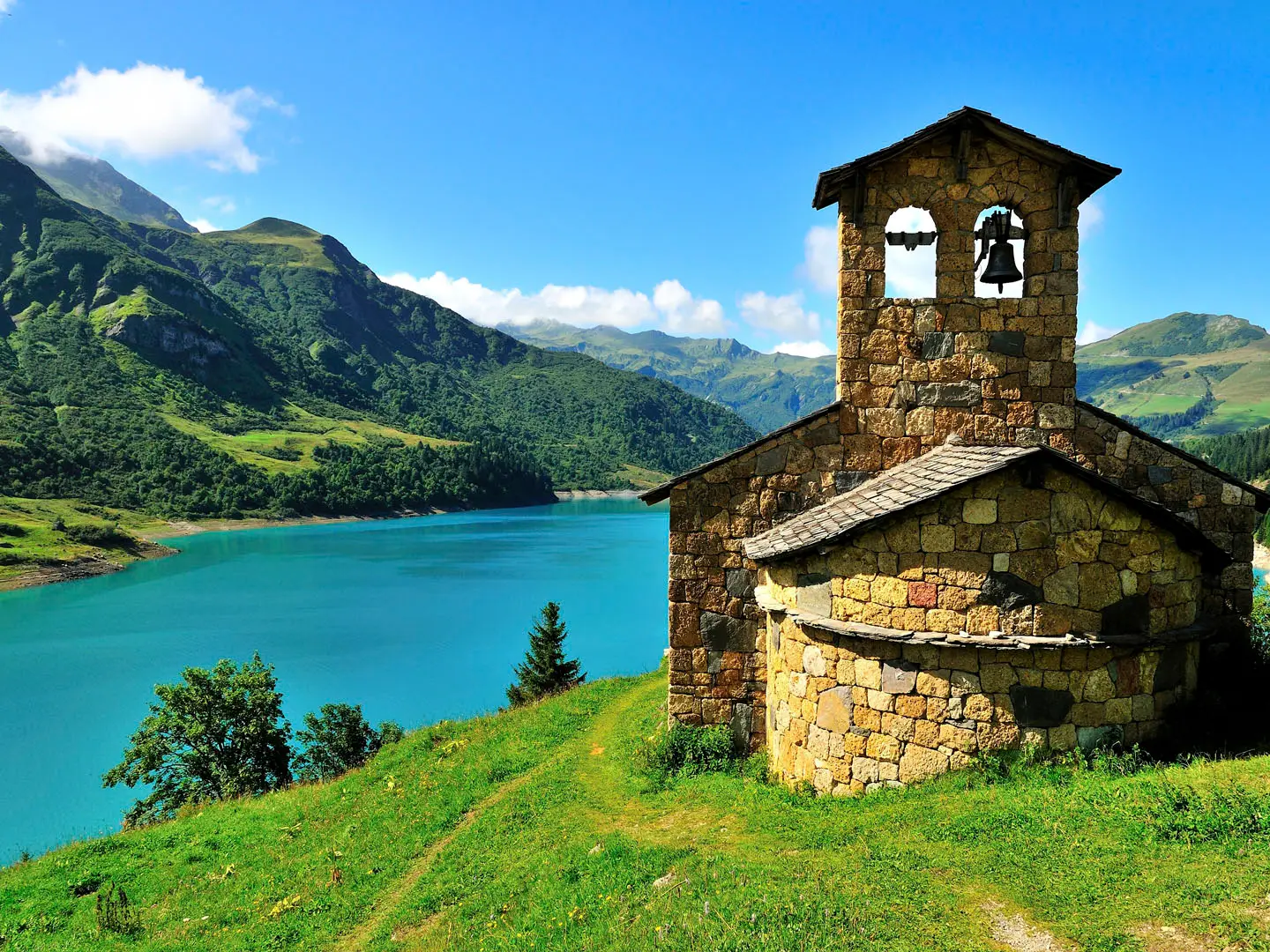
- Lac de Roselend (~1,550 m): A large turquoise dam reservoir ringed by alpine pastures, with the Chapelle de Roselend on its shore. It is one of the scenic centrepieces of the Beaufortain.
- Refuge de Presset and Lac de Presset (~2,514 m): A modern FFCAM refuge beside a high glacial lake. The setting gives classic views towards the Pierra Menta and makes a memorable overnight stop.
- Pierra Menta (2,714 m): A striking rock tower with a near-vertical wall, visible from the Presset area. The trek sees it from the route rather than climbing it.
- Col du Grand Fond (~2,671 m): The highest point on the trail. This rugged pass gives wide views over Beaufortain peaks and lakes before the descent towards Presset.
- Lac de Saint-Guérin: An emerald reservoir crossed by a Himalayan-style suspension footbridge. It is a popular photo stop in the heart of the massif.
- Beaufort cheese country: The valley of Beaufort and its alpages are home to Beaufort AOP cheese, with Tarine cows and working summer dairy chalets shaping the route’s Savoyard character.
Challenges to expect
Expect sustained ascent, long daily climbs and rough mountain paths over rocky passes and ridges. The route is well maintained and non-technical, but the altitude, weather changes and possible early-season snowfields on north-facing slopes can slow progress. Refuges are the main accommodation, so book ahead in season. The shared Tour du Mont Blanc and GR5 section near Refuge de la Croix du Bonhomme can be busy; for a lower-mountain contrast, see the Ballons des Vosges Park trails.
HikeList Score
Tour de Beaufortain scored 83/100 on HikeList's trail-quality metrics.
See score breakdownHide breakdown
- Ideal length 100
- Balanced challenge 80
- Scenery & wildness 98
- Varied terrain 64
- Accommodation 67
- Food & support 65
- Path quality 98
- Season flexibility 76
Computed from length, challenge, scenery & wildness, terrain variety, accommodation, food & support, path quality and season flexibility.
 France
Show more data Show less
- Mountainous
- Forest
- Dirt
- Rocky
- Huts
- Campsites
- Wild Camping Spots
- Pet Friendly
- Water Sources
- Campsites
- Shelters
Photos from hikers
Taken on the trail by people who've reviewed Tour de Beaufortain.
Beginning from Queige, the route climbs steadily through forested slopes and open meadows, offering first glimpses of the Beaufortain peaks above. The path alternates between dirt and rocky track, passing several traditional chalets before ascending to the Col de la Forclaz. After enjoying panoramic views, descend through alpine pastures and wildflower fields to arrive at the picturesque village of Arêches, known for its Savoyard character and local cheese.
Leaving Arêches, the trail climbs through wooded hillsides, passing alpine barns and grazing cows on the way to the Col du Pré. The views open up dramatically of the Mont Blanc massif before descending towards the turquoise waters of Lac de Roselend. The section concludes near lakeside refuges, with the opportunity to rest and soak in stunning surroundings.
Following the shore of Lac de Roselend, the trail soon begins a steady climb past Lac de la Gittaz. This day features some of the most remote and wild terrain of the route, with impressive views and dramatic alpine landscapes. The path traverses high pastures, with a challenging ascent to the Refuge de Presset, surrounded by soaring peaks and nestled beside a tranquil high mountain lake.
From Refuge de Presset, begin with a dramatic crossing of Col du Grand Fond, the high point of the trek. Descend into the wild Ormette valley, then weave through rocky outcrops and lush shepherd pastures. After passing several small alpine hamlets, the section concludes at Plan de la Lai, an area with options for camping or hut lodging.
Leaving Plan de la Lai, the trail undulates through a spectacular landscape of grassy ridges and pine forests. Pass under the imposing flanks of Mont Coin and through habitats rich in wildflowers and wildlife. The route then descends towards the scenic reservoir of Saint-Guérin, where hikers can visit a small chapel and enjoy peaceful lakeside views.
The final stage leads from Saint-Guérin through undulating woodlands and alpine plateaus dotted with pastoral buildings. After a gentle but long descent, pass through forested trails and open clearings, gradually returning to Queige. This concluding section is less technical, providing a scenic close to the full circuit with broad landscapes and peaceful stretches.
Reviews
How would you rate Tour de Beaufortain?
Tap a star to start your review — you could be the first.