Chartreuse Trail (GR9 Segment)
How would you rate Chartreuse Trail (GR9 Segment)?
Tap a star to share your experience and help other hikers.
Chartreuse Trail (GR9 Segment): Grenoble to Chambéry Traverse
HikeList Score
Chartreuse Trail (GR9 Segment) scored 84/100 on HikeList's trail-quality metrics.
See score breakdownHide breakdown
- Ideal length 85
- Balanced challenge 80
- Scenery & wildness 85
- Varied terrain 83
- Accommodation 83
- Food & support 81
- Path quality 98
- Season flexibility 76
Computed from length, challenge, scenery & wildness, terrain variety, accommodation, food & support, path quality and season flexibility.
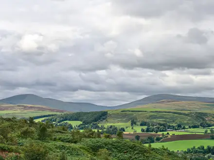
The Chartreuse Trail is the Chartreuse section of the GR9, crossing the Chartreuse massif in the French Pre-Alps between Grenoble and Chambéry. This point-to-point 85 km traverse takes 4–6 days, with about 4,200 m of ascent, and is a hard mountain walk suited to experienced hikers comfortable with long climbs, rocky limestone paths and limited water. It is one of the classic multi-day routes for hiking in France; for another dramatic French mountain option, compare the Cirque de Gavarnie Trails.
Route Overview
This is the classic Traversée de la Chartreuse, following the white-and-red GR9 waymarks through the Parc naturel régional de la Chartreuse between the mainline rail stations of Grenoble and Chambéry. It can be walked south-to-north or north-to-south. Key places on or near the line include the Bastille and Fort du Saint-Eynard above Grenoble, Le Sappey-en-Chartreuse, Col de Porte, Chamechaude, Saint-Pierre-de-Chartreuse, the Grande Chartreuse monastery area, Col du Cucheron, Saint-Pierre-d’Entremont, the Hauts de Chartreuse Nature Reserve and the northern exit towards Chambéry. If you want lower, gentler French park walking, see the Ballons des Vosges Park Trails; for a very different non-alpine route, see the Alsace Vineyard Trail.
Chartreuse: monastery, nature park and GR9 crossing
The massif takes its name from the Grande Chartreuse, founded in 1084 by Saint Bruno of Cologne and still the mother house of the Carthusian order. The same monastic tradition later gave its name to Chartreuse herbal liqueurs. The wider massif became the Parc naturel régional de la Chartreuse in 1995, and the high plateaus were protected as the Réserve naturelle des Hauts de Chartreuse in 1997. The GR9 threads this landscape as part of a much longer Grande Randonnée route from the Jura to the Mediterranean.
Notable highlights
- Chamechaude (2,082 m): The highest point of the Chartreuse massif and the traverse’s high point or summit option. Its limestone crest rises above Col de Porte, with wide views towards Belledonne and, in clear weather, Mont Blanc.
- Grande Chartreuse monastery: The mother house of the Carthusian order, founded by Saint Bruno in 1084. The enclosed monastery cannot be visited, but the nearby La Correrie museum explains its history near Saint-Pierre-de-Chartreuse.
- Cirque de Saint-Même: A limestone amphitheatre at the head of a valley, where the Guiers Vif rises and waterfalls spill over the cliffs. It is one of the major natural sights on the northern Chartreuse stages.
- Dent de Crolles (2,062 m): A castle-like karst summit on the eastern rock barrier of the massif. It is known for its extensive cave system and its position above the Hauts de Chartreuse.
- Hauts de Chartreuse Nature Reserve: A protected high plateau of alpine pasture and cliff terrain crossed by the route. Access, behaviour and bivouac are regulated, so check current reserve rules before you go.
- Mont Granier (1,933 m): The northern sentinel of the Chartreuse above Chambéry. Its huge north face and historic 1248 rock-slide make it a memorable landmark near the end of the traverse.
Challenges to expect
Expect sustained mountain days, including climbs of around 1,000 m or more on some stages, rocky and rooty paths, scree, bare limestone and occasional cabled or secured passages. The porous karst terrain makes water scarce: carry 2–3+ litres and plan refills in villages or at known springs. High passes may hold snow into early summer, and bivouac is restricted in parts of the Hauts de Chartreuse reserve.
HikeList Score
Chartreuse Trail (GR9 Segment) scored 84/100 on HikeList's trail-quality metrics.
See score breakdownHide breakdown
- Ideal length 85
- Balanced challenge 80
- Scenery & wildness 85
- Varied terrain 83
- Accommodation 83
- Food & support 81
- Path quality 98
- Season flexibility 76
Computed from length, challenge, scenery & wildness, terrain variety, accommodation, food & support, path quality and season flexibility.
 France
Show more data Show less
- Mountain
- Forest
- Alpine Meadow
- Dirt
- Rock
- Gravel
- Mountain Huts
- Guesthouses
- Hotels
- Family Friendly
- Pet Friendly
- Water Sources
- Campsites
- Shelters
Photos from hikers
Taken on the trail by people who've reviewed Chartreuse Trail (GR9 Segment).
Reviews
How would you rate Chartreuse Trail (GR9 Segment)?
Tap a star to start your review — you could be the first.