The Sma’ Glen Trail
How would you rate The Sma’ Glen Trail?
Tap a star to share your experience and help other hikers.
The Sma’ Glen Trail: Highland Edge Day Walk from Newton Bridge
HikeList Score
The Sma’ Glen Trail scored 80/100 on HikeList's trail-quality metrics.
See score breakdownHide breakdown
- Ideal length 55
- Balanced challenge 100
- Scenery & wildness 71
- Varied terrain 83
- Accommodation 100
- Food & support 67
- Path quality 92
- Season flexibility 89
Computed from length, challenge, scenery & wildness, terrain variety, accommodation, food & support, path quality and season flexibility.
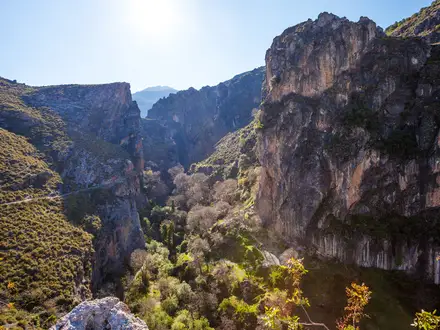
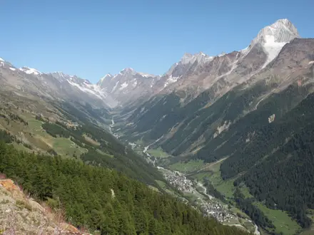
The Sma’ Glen Trail is a 9.5 km moderate out-and-back day walk in Highland Perthshire, Scotland, starting at Newton Bridge on the A822 near Crieff. It is not an official waymarked long-distance trail; this route follows the popular riverside estate track through Glen Almond beside the River Almond. It suits walkers wanting a short Highland-edge glen walk with history, steep craggy scenery and straightforward logistics, without committing to the rougher hill variants.
Route Overview
Start at Newton Bridge car park on the A822, where General Wade’s old stone bridge crosses the River Almond. From here, the walk heads west/south-west up Glen Almond on a private estate road/track, following the river through the narrow Sma’ Glen pass before retracing the same line back to the start. Key features include the River Almond, Ossian’s Stone and views up to the surrounding ridges, including Dun Mor and The Scurran. Road access is via the A822 between Crieff and Aberfeldy. For other Scottish route ideas, compare the Arran Coastal Way, Annandale Way or Beinn Eighe Mountain Trail.
Military Roads, Ossian’s Stone and an Ancient Highland Route
The Sma’ Glen was an ancient route from the Lowlands into the Highlands. In the 1730s, General Wade built a military road from Crieff through the glen to Aberfeldy and Loch Tay after the Jacobite risings. During construction, workers disturbed Ossian’s Stone, reputedly linked to the legendary Celtic bard Ossian, son of Fingal; burnt bones found beneath were later reburied locally on Dun Mor. The glen also appeared in the 1981 film Chariots of Fire.
Notable highlights
Ossian’s Stone (Clach Ossian): A large square boulder near the top of the glen, traditionally associated with the grave of the legendary bard Ossian. Its story is tied directly to the building of General Wade’s military road.
General Wade’s military road and Newton Bridge: The walk starts at the old stone bridge at Newton Bridge, part of the 18th-century military road from Crieff to Aberfeldy. It gives the route a clear historical anchor from the first steps.
River Almond and Glen Almond: The route follows the fast-flowing River Almond along the flat green strath floor. Expect easy valley walking with crags, small waterfalls and the chance of seeing dippers on river rocks.
Sma’ Glen pass: This narrow, steep-sided pass sits on the edge of the Highlands and is often described as the “Highlands in miniature”. It delivers a big-glen feel without a long approach.
Dun Mor hill fort: Dun Mor rises above the eastern side of the glen and is topped by a prehistoric fort. It is part of tougher hill variants rather than the standard riverside out-and-back.
Challenges to expect
The listed route is moderate and mostly straightforward on an obvious estate track, but the glen is exposed in poor weather and wet ground is common. Do not ford the River Almond in spate. If you leave the valley floor for Dun Mor, The Scurran or longer hill circuits, expect rough, boggy, pathless ground and the need for map, compass or GPS navigation.
HikeList Score
The Sma’ Glen Trail scored 80/100 on HikeList's trail-quality metrics.
See score breakdownHide breakdown
- Ideal length 55
- Balanced challenge 100
- Scenery & wildness 71
- Varied terrain 83
- Accommodation 100
- Food & support 67
- Path quality 92
- Season flexibility 89
Computed from length, challenge, scenery & wildness, terrain variety, accommodation, food & support, path quality and season flexibility.
Show more data Show less
- River
- Glen
- Mountain Pass
- Estate Track
- Rough
- Boggy
- Hotels
- B&Bs
- Inns
- Campsites
- Family Friendly
- Pet Friendly
- Water Sources
Photos from hikers
Taken on the trail by people who've reviewed The Sma’ Glen Trail.
Reviews
How would you rate The Sma’ Glen Trail?
Tap a star to start your review — you could be the first.