De Meinweg National Park Trail
How would you rate De Meinweg National Park Trail?
Tap a star to share your experience and help other hikers.
De Meinweg National Park Trail: Hilly Heathland on the Dutch-German Border
HikeList Score
De Meinweg National Park Trail scored 81/100 on HikeList's trail-quality metrics.
See score breakdownHide breakdown
- Ideal length 55
- Balanced challenge 100
- Scenery & wildness 78
- Varied terrain 100
- Accommodation 66
- Food & support 88
- Path quality 98
- Season flexibility 89
Computed from length, challenge, scenery & wildness, terrain variety, accommodation, food & support, path quality and season flexibility.
De Meinweg National Park Trail is a 9.5 km circular day walk in Nationaal Park De Meinweg, Limburg, in the south-east Netherlands, just east of Roermond and Herkenbosch. Allow roughly 2.5-3.5 hours; difficulty is easy to moderate, with non-technical but sandy, wet and sometimes steep paths. It suits walkers who want a short Dutch loop with more relief than usual, plus heath, forest, fens and border-country wildlife. For wider planning, see our Netherlands hiking guides.
Route Overview
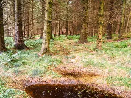
The listed route is a loop, so you finish where you start; visitor parking is available at Melickerbosweg, and the park is also reachable by public transport from nearby settlements such as Herkenbosch and Roermond. Expect a largely unpaved circuit through pine and old oak-birch forest, dry and wet heathland, sandy tracks, boardwalk sections and short climbs over the terrace edges towards the Beatrix Plateau. The dense marked network also includes shorter family loops and longer options such as the Meinvennen route, which briefly crosses into Germany. For flatter wetland walking, compare the Biesbosch National Park Trail; for sandy heath and forest, see the Brabantse Kempen Trail.
Shared Common Land and the Iron Rhine Railway
The name “Meinweg” comes from a medieval common, or “gemeyne”: shared grazing and woodland used jointly by fourteen surrounding villages. That communal history still fits the landscape, where woods, heath and stream valleys meet on the Dutch-German border. Several walking routes also cross the historic IJzeren Rijn, or Iron Rhine railway, built in the 1870s to link Antwerp with the German Ruhr. The former monastery of Sint Ludwig stands on the edge of the park.
Notable highlights
- Terraced landscape and the Beatrix Plateau (about 80 m NAP): Three river terraces create a height difference of about 50 m between the Roer valley and the highest plateau, giving this Dutch walk unusual relief.
- Purple heathlands (August-September): The heath turns purple in late summer, especially across the open dry and wet heath sections.
- The adder (last refuge in Limburg): De Meinweg is the only place in Limburg where the European adder still occurs; sunny heath edges are also habitat for other reptiles.
- Rode Beek stream: This clear, iron-tinged brook partly marks the German frontier and flows towards the Roer, adding a distinctive stream-valley section to the walk.
- IJzeren Rijn railway: The old Antwerp-Ruhr railway cuts through the woods, giving a visible industrial-history marker in an otherwise natural landscape.
- Cross-border setting: The park is enclosed on three sides by Germany and forms part of the Maas-Swalm-Nette Nature Park; longer loops can briefly step over the border. For another Dutch borderland-feel route, see the Brabantse Wal Trail.
Challenges to expect
This is not a technical hike, but it is rougher than many Dutch lowland walks. Expect sandy and gravel forest tracks, narrow heath paths, wet or boggy ground after rain, boardwalks over fens and short steep climbs at terrace edges. The path network is dense and route lengths vary by source, so follow the waymarks carefully and consider carrying a map or GPS track.
HikeList Score
De Meinweg National Park Trail scored 81/100 on HikeList's trail-quality metrics.
See score breakdownHide breakdown
- Ideal length 55
- Balanced challenge 100
- Scenery & wildness 78
- Varied terrain 100
- Accommodation 66
- Food & support 88
- Path quality 98
- Season flexibility 89
Computed from length, challenge, scenery & wildness, terrain variety, accommodation, food & support, path quality and season flexibility.
 Netherlands
Show more data Show less
- Forest
- Heathland
- Wetland
- River Valleys
- Sand
- Gravel
- Dirt
- Boardwalk
- Hotels
- Campsites
- Family Friendly
- Pet Friendly
- Restrooms
- Water Sources
- Campsites
- Picnic Areas
Photos from hikers
Taken on the trail by people who've reviewed De Meinweg National Park Trail.
Reviews
How would you rate De Meinweg National Park Trail?
Tap a star to start your review — you could be the first.