The Caledonian Canal Towpath
How would you rate The Caledonian Canal Towpath?
Tap a star to share your experience and help other hikers.
The Caledonian Canal Towpath: Great Glen Waterside Walk
HikeList Score
The Caledonian Canal Towpath scored 82/100 on HikeList's trail-quality metrics.
See score breakdownHide breakdown
- Ideal length 85
- Balanced challenge 50
- Scenery & wildness 98
- Varied terrain 64
- Accommodation 92
- Food & support 88
- Path quality 98
- Season flexibility 89
Computed from length, challenge, scenery & wildness, terrain variety, accommodation, food & support, path quality and season flexibility.
The Caledonian Canal Towpath is a low-level waterside walk across the Scottish Highlands, following Thomas Telford’s canal corridor from Corpach/Banavie near Fort William to Inverness. The full canal corridor is 97 km and a fit walker can cover it in about 5 days. Difficulty is easy on the flat towpath sections, but expect long days if walking coast to coast. It suits hikers who want Great Glen scenery, lochs, locks and straightforward navigation rather than mountain terrain.
Route Overview
This is a point-to-point route, normally walked south-west to north-east from the sea lock at Corpach/Banavie to Inverness and the Beauly Firth, which can put the prevailing wind behind you. Key places in order are Neptune’s Staircase, Gairlochy, Laggan Locks, Fort Augustus, Invermoriston, Drumnadrochit, Dochgarroch and Inverness. The corridor links towpath with lochside and forest tracks around Loch Lochy, Loch Oich, Loch Ness and Loch Dochfour. Both ends have good transport links. For a different canal walk, compare the Ashby Canal Trail; for Scottish coastal alternatives, see the Arran Coastal Way or Ayrshire Coastal Path.
Caledonian Canal history
The Caledonian Canal was surveyed and designed by Thomas Telford, authorised by Parliament in 1803 and opened in 1822. It uses the Great Glen, linking Loch Lochy, Loch Oich, Loch Ness and Loch Dochfour with man-made cuttings so vessels could cross Scotland without rounding the north coast and the Pentland Firth. Built partly to provide Highland employment, it later lost commercial importance to railways and larger ships. Its towpaths are now part of the modern Great Glen Way corridor.
Notable highlights
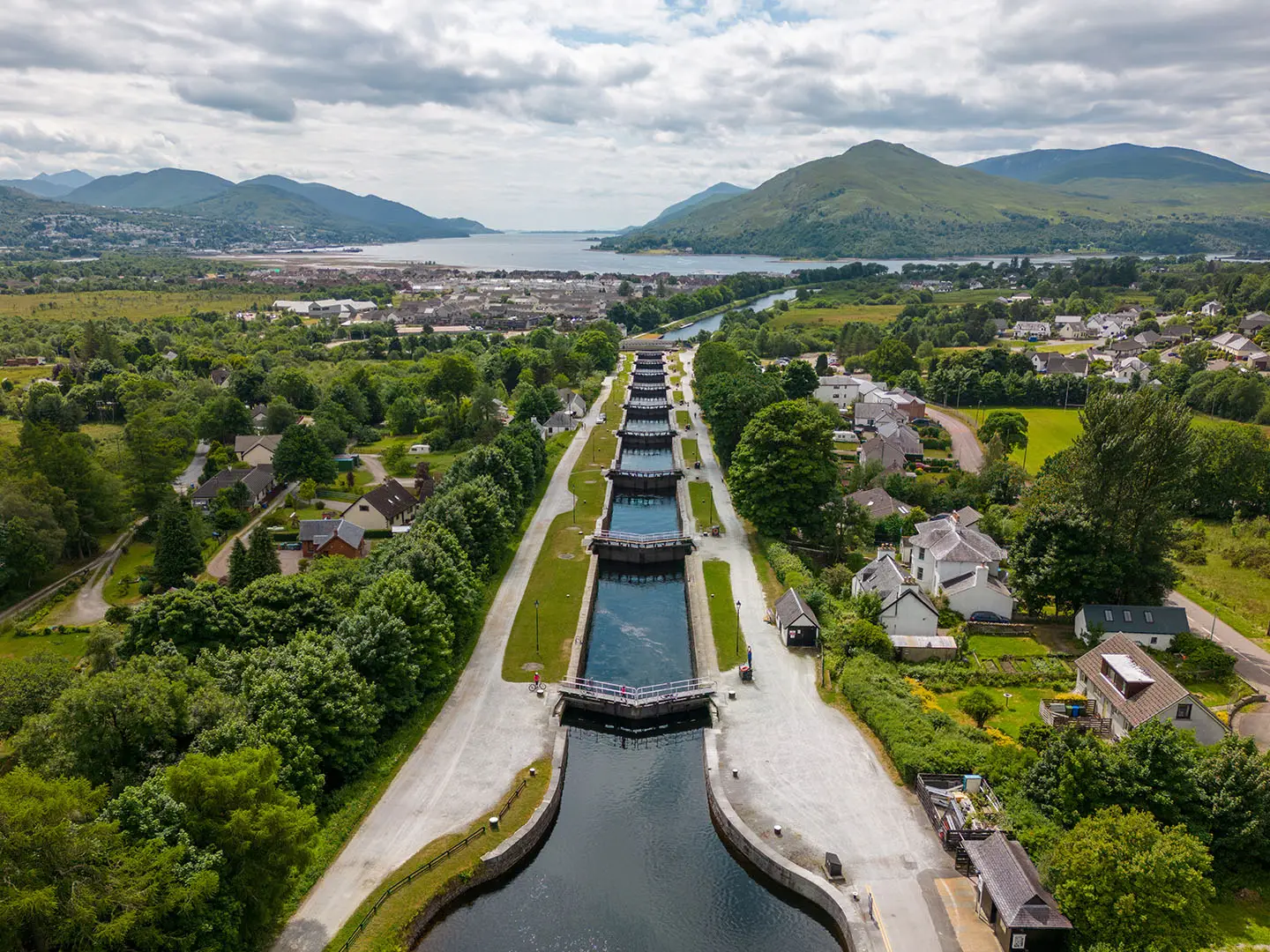
Neptune’s Staircase: A flight of eight connected locks at Banavie near the western end. The towpath runs beside the locks, with views towards the Ben Nevis massif.
The Caledonian Canal: Telford’s coast-to-coast waterway is only partly man-made; the rest uses the natural lochs of the Great Glen. Hikers pass locks, swing bridges, cottages and long level towpath sections.
Fort Augustus: The midway village at the south-western tip of Loch Ness has a five-lock staircase where the canal drops into the loch. It is a useful rest and resupply stop.
Loch Ness: The route follows the famous loch for much of its eastern half. Expect broad waterside views and the well-known monster folklore.
Urquhart Castle: A medieval ruin on a promontory above Loch Ness near Drumnadrochit. It is a strong side-interest for hikers wanting history and loch views.
Inverness finish: The route reaches the Highland capital via Dochgarroch and Clachnaharry sea lock, ending with full town amenities and onward transport.
Challenges to expect
The towpath is flat and well surfaced, but the coast-to-coast walk is not effortless: 97 km in 5 days means long stages. Surfaces include compacted gravel, dirt, forest tracks and short quiet-road sections, with mud after rain. Navigation is usually simple, but take care at roads and swing bridges. Summer midges can be irritating, and wind, rain and short winter daylight matter on this exposed Great Glen corridor. For a quieter Scottish inland route, compare the Annandale Way.
HikeList Score
The Caledonian Canal Towpath scored 82/100 on HikeList's trail-quality metrics.
See score breakdownHide breakdown
- Ideal length 85
- Balanced challenge 50
- Scenery & wildness 98
- Varied terrain 64
- Accommodation 92
- Food & support 88
- Path quality 98
- Season flexibility 89
Computed from length, challenge, scenery & wildness, terrain variety, accommodation, food & support, path quality and season flexibility.
 United Kingdom
 Scotland
Show more data Show less
- Wetlands
- Mountainous
- Gravel
- Dirt
- Hotels
- Hostels
- Campsites
- Wild Camping Spots
- Family Friendly
- Pet Friendly
- Restrooms
- Water Sources
- Campsites
- Picnic Areas
In these collections
Photos from hikers
Taken on the trail by people who've reviewed The Caledonian Canal Towpath.
Starting at Corpach near Fort William, Day 1 follows the canal from its western entrance past the engineering marvel of Neptune’s Staircase, the longest staircase lock in Britain. The route continues north through Banavie and along the tranquil waters of the canal, offering views towards Ben Nevis, before reaching Gairlochy at the southern end of Loch Lochy. The terrain is generally flat and follows a well-maintained towpath for easy hiking.
On Day 2, hikers traverse the length of Loch Lochy, following the canal towpath through woodland and alongside the water’s edge. Passing the scenic villages of Achnacarry and Clunes, the route is peaceful and lined with frequent spots for picnics or wildlife watching. The section ends at the Laggan Locks, where Loch Lochy meets Loch Oich, and nearby accommodation and food options are available.
Day 3 continues along Loch Oich, passing through Kytra Lock and lush woodland before reaching Fort Augustus. This day features classic Highland scenery, including forested paths and glimpses of local wildlife. Arriving in Fort Augustus, hikers can enjoy shops, cafes, and the impressive staircase of canal locks that descend into Loch Ness.
Leaving Fort Augustus, the trail follows the southwestern shore of Loch Ness, with forested segments and clearings offering iconic views across the famous loch. This stage is slightly more undulating than previous days but stays on good track surfaces. The route ends in the busy village of Drumnadrochit, known for its proximity to Urquhart Castle and the Loch Ness Centre.
The final stretch leads from Drumnadrochit to Inverness, following a combination of canal towpath and minor roads as it leaves Loch Ness and rejoins the Caledonian Canal at Dochgarroch. The last kilometers are mainly flat and easy, leading hikers into Inverness, the capital of the Highlands, where the route ends close to the heart of the city and its amenities.
Reviews
How would you rate The Caledonian Canal Towpath?
Tap a star to start your review — you could be the first.