Speyside Way
How would you rate Speyside Way?
Tap a star to share your experience and help other hikers.
Speyside Way: A Complete Hiking Guide
HikeList Score
Speyside Way scored 95/100 on HikeList's trail-quality metrics.
See score breakdownHide breakdown
- Ideal length 93
- Balanced challenge 100
- Scenery & wildness 90
- Varied terrain 100
- Accommodation 100
- Food & support 88
- Path quality 98
- Season flexibility 89
Computed from length, challenge, scenery & wildness, terrain variety, accommodation, food & support, path quality and season flexibility.
The Speyside Way is a 137 km / 85 mile point-to-point trail from Buckie on the Moray Firth to Newtonmore in the Cairngorms. One of Scotland’s Great Trails, it follows the River Spey through malt whisky country and suits hikers wanting a moderate, well-waymarked long-distance walk. This guide uses 6 days as a standard schedule, though the full route is often walked over 6–9 days. See more Scotland hiking routes if you are comparing national trails.
Route Overview
The route runs south-west from Buckie via Spey Bay, Fochabers, Craigellachie, Aberlour, Ballindalloch, Grantown-on-Spey, Nethy Bridge / Boat of Garten and Aviemore, then on to Kincraig and Newtonmore. The historic end point was Aviemore; the present full route continues to Newtonmore. A short spur from Craigellachie reaches Dufftown, and a longer optional spur goes to Tomintoul. Terrain changes from open coast and riverbank to old railway lines, forest tracks, farmland and exposed heather moorland. It is point-to-point, so plan start and finish logistics before committing to accommodation. For other Scottish long-distance options, compare the Annandale Way or the island-based Arran Coastal Way.
Speyside Way history
The Speyside Way first opened in 1981 between Spey Bay and Ballindalloch. A spur to Tomintoul was added in 1990, followed by a northern extension from Spey Bay to Buckie in 1999. In April 2000 the route was extended south from Ballindalloch to Aviemore. The final southern extension from Aviemore to Newtonmore, much of it using the former Strathspey Railway, was completed in 2020.
Notable highlights
- River Spey: The Way shadows the Spey for much of its length. It is one of Scotland’s fastest-flowing rivers and is closely associated with salmon fishing.
- Speyside whisky distilleries: The trail passes through Speyside malt whisky country, near places including Aberlour, Craigellachie, Cragganmore, Macallan and Cardhu. The Dufftown spur adds access to Glenfiddich and Balvenie.
- Cairngorms National Park: The southern half enters the UK’s largest national park, with views towards the Cairngorm mountains on the approach to Aviemore.
- Spey Bay and the Moray Firth: The coastal start sits at the mouth of the River Spey. Spey Bay is known for bottlenose dolphin watching and the Scottish Dolphin Centre.
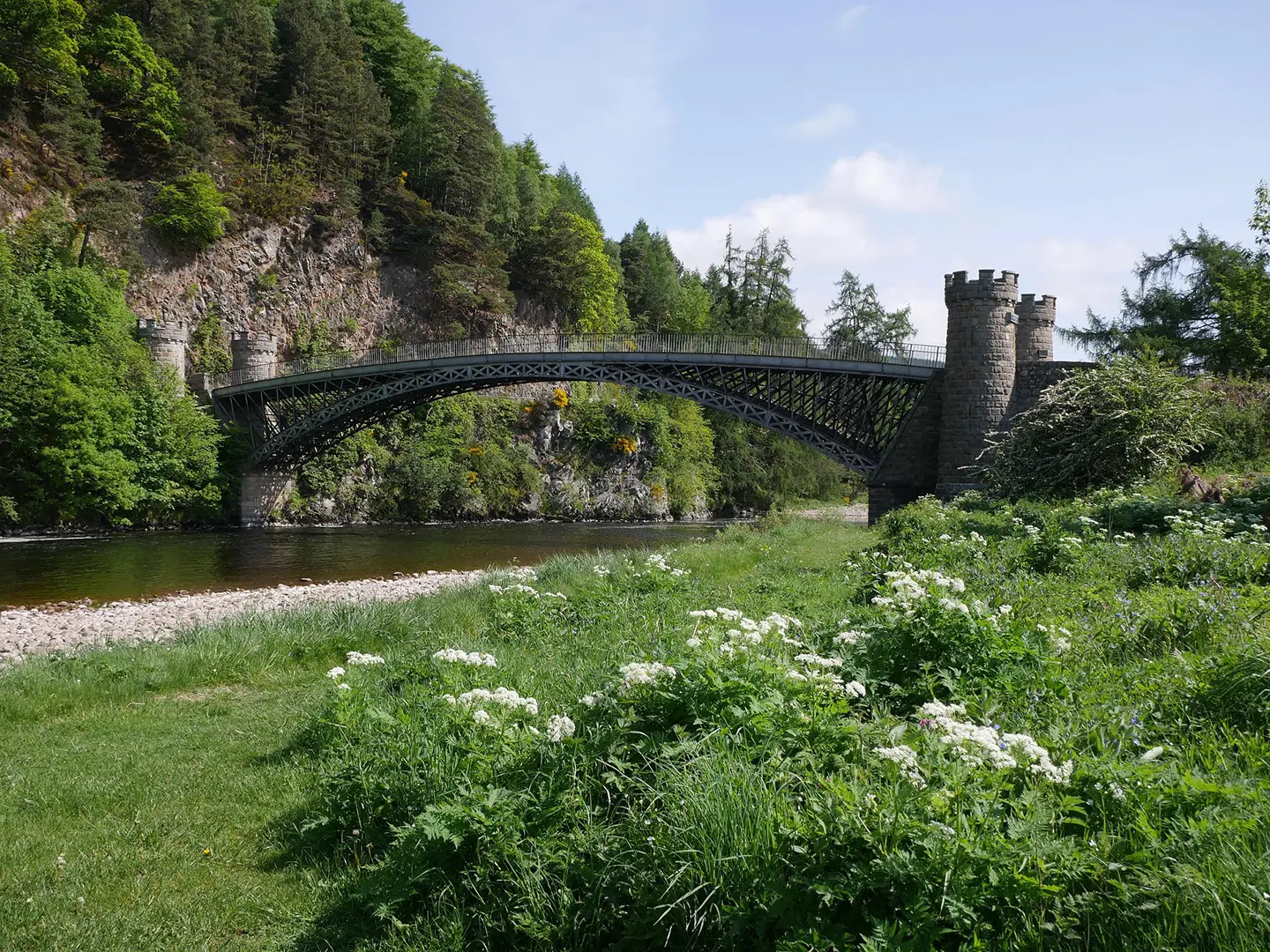
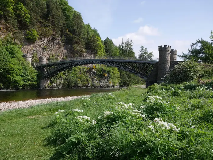
- Craigellachie Bridge: This cast-iron bridge over the Spey was designed by Thomas Telford and opened in 1814. It is one of the route’s clearest historic landmarks.
- Former Strathspey Railway: Long sections use disused railway lines, giving easier, near-level walking and links with the heritage Strathspey Steam Railway around Aviemore and Boat of Garten.
Challenges to expect
The Speyside Way is mostly low-level and well waymarked, but it is not flat throughout. The shoulder of Ben Aigan is the highest point on the main route, and Ballindalloch to Grantown-on-Spey is the hardest main-line section. Expect mixed surfaces: railway trackbed, woodland paths, farm and forest tracks, minor tarmac and rougher hill tracks. The Tomintoul spur is tougher, climbing over Carn Daimh.
HikeList Score
Speyside Way scored 95/100 on HikeList's trail-quality metrics.
See score breakdownHide breakdown
- Ideal length 93
- Balanced challenge 100
- Scenery & wildness 90
- Varied terrain 100
- Accommodation 100
- Food & support 88
- Path quality 98
- Season flexibility 89
Computed from length, challenge, scenery & wildness, terrain variety, accommodation, food & support, path quality and season flexibility.
 United Kingdom
 Scotland
Show more data Show less
- Coastal
- River Valley
- Forest
- Farmland
- Moorland
- Old Railway Trackbed
- Forest Tracks
- Farm Tracks
- Woodland Paths
- Minor Tarmac Roads
- Rough Hill Tracks
- B&Bs
- Guesthouses
- Hotels
- Hostels
- Bunkhouses
- Wigwams
- Family Friendly
- Dog Friendly On Leash
- Restrooms
- Established Campsites
- Picnic Areas
- Public Transport Access Points
Download Our Full Guide to Speyside Way FREE!
Get our comprehensive guide to this hike for free. Save it for later reading or print out at home.
Articles related to this hike
Photos from hikers
Taken on the trail by people who've reviewed Speyside Way.
Speyside Way: The Complete Guide
 i
Image by db2000
i
Image by db2000 The Speyside Way is a well-waymarked Scottish Great Trail linking Buckie on the Moray Firth with Newtonmore in the Cairngorms National Park, following the River Spey from coast and estuary into whisky country and the mountain foothills. Its character is practical and varied rather than extreme: disused railway trackbed, riverside paths, forest and farm tracks, a few rougher upland sections, with Spey Bay, Craigellachie Bridge, Grantown-on-Spey, the Strathspey Railway corridor, Insh Marshes and Ruthven Barracks giving the route its strongest sense of place.
The walk asks for sensible planning more than technical skill: accommodation is patchier in the middle, bus links between sections are limited, and the shoulder of Ben Aigan, the Ballindalloch to Grantown-on-Spey moorland and the long Aviemore to Newtonmore leg all need treating with respect. This guide covers how to break the route into stages and days, where to sleep and resupply, how transport works, what the terrain is like underfoot, and the common mistakes to avoid.
Stage-by-Stage Guide
The Speyside Way is generally well waymarked with wooden thistle-in-hexagon posts, but each day has a different character. Carry a map or GPS track as backup, particularly for the longer inland sections where villages are further apart. Do not rely on untreated water from the River Spey; carry enough between settlements.
Stage 1: Buckie to Fochabers
Distance: 17.2 km / 10.7 miles
Character: easy, near-flat coastal and riverside walking
The route begins at Cluny Square in Buckie and gives a gentle introduction to the Way: harbour, coast, old railway line, river mouth and woodland. Underfoot it is mostly shoreline path, pavement, disused railway trackbed, woodland path and field-edge walking, with some sandy or bark-surfaced sections around Spey Bay and Warren Wood.
Leaving Buckie, the Way passes Buckpool Harbour before following the Moray Firth coast towards Portgordon. Portgordon has a shop and makes a useful early stop before the route turns inland on old railway trackbed towards Spey Bay. The mouth of the Spey is the key feature of the day: a broad, dynamic river mouth where one of Scotland’s fastest-flowing rivers meets the sea. The Scottish Dolphin Centre at Spey Bay has a cafe, toilets and information, and the area is known for bottlenose dolphins, seals, otters and ospreys, though sightings are never guaranteed.
From Spey Bay the route continues through Warren Wood and Bellie Wood, then follows riverside and woodland paths into Fochabers, a Georgian planned village on the A96.
Food and water: carry water from Buckie. Portgordon has a shop, the Scottish Dolphin Centre cafe is seasonal, and Fochabers has shops, pubs, cafes and an ATM.
Accommodation: Fochabers has B&Bs, a hotel and a campsite on the eastern edge of the village. Book ahead in peak walking season.
Transport and access: Fochabers has bus links to Buckie and Elgin. There is no railway station in Fochabers; the nearest rail options are Elgin and Keith, with onward bus or taxi connections.
Navigation and cautions: navigation is straightforward and the stage is well waymarked. Some woodland and riverside sections near Spey Bay are narrow; walkers are fine, but cyclists and horse riders may need to dismount where signed or where space is tight. This is the easiest day of the six-day itinerary.
Stage 2: Fochabers to Craigellachie
Distance: about 21 km / 13 miles
Character: moderate; forest walking with the main route’s highest point
This is a more physical day than the opener. The stage leaves Fochabers from the area of the cricket pitch and climbs through mixed forest above the Spey valley. It includes woodland paths, tarred road sections and forestry tracks, with some steps soon after Fochabers and again north of Boat o’ Brig; both step sections can be bypassed by road alternatives.
A worthwhile early landmark is the Earth Pillars viewpoint, where eroded sandstone columns look out over the Spey valley. The route then continues through Ben Aigan forest and crosses the shoulder of Ben Aigan at around 270 m, the highest point on the main Speyside Way. This is a genuine climb and the hardest part of the northern half of the route, but it is not a mountain ascent; the 471 m summit of Ben Aigan is not on the main trail.
After the high section the Way descends to Boat o’ Brig, which has road access, then continues on forest road and woodland path towards Bridge of Fiddich and Craigellachie. Craigellachie sits at the meeting of the Fiddich and Spey rivers. Thomas Telford’s cast-iron Craigellachie Bridge, opened in 1814, is an essential short detour or viewpoint before finishing around Fiddich Park.
Food and water: there are limited reliable services between Fochabers and Craigellachie, so leave Fochabers with enough food and water for the full stage. Craigellachie has a village shop and pub/hotel options.
Accommodation: Craigellachie has several places to stay, and Aberlour, around 3.5 km further along the route, is another practical accommodation base if Craigellachie is full.
Transport and access: there is no railway station at Craigellachie and bus services are limited. Craigellachie Cars operates locally on 07960 567118. Boat o’ Brig offers useful road access if a shorter day or pickup is needed.
Navigation and cautions: the waymarking is generally clear. The combination of climb, tarmac and forest roads can feel harder on the legs than the distance suggests, so allow a slower pace than on Stage 1. In poor weather the open shoulder of Ben Aigan is more exposed, though the route remains a moderate walking route rather than technical hill terrain.
Stage 3: Craigellachie to Ballindalloch
Distance: 19.6 km / 12.2 miles
Character: easy, mostly flat railway-path walking through whisky country
This is one of the simplest days underfoot and one of the best for Speyside’s whisky heritage. From Craigellachie, the Way passes close to Telford’s Craigellachie Bridge and then follows the former Strathspey Railway trackbed south. The surface is firm, well drained and almost completely flat, with some farmland and riverside sections.
Aberlour is reached after about 3 km and is the obvious place for a morning stop or early lunch. The village has shops, food options, The Mash Tun pub and whisky bar, Aberlour Distillery and Visitor Centre, and the Walkers shortbread factory. Distillery tours and tastings should be booked ahead, and current access and opening times should be checked before travelling.
South of Aberlour, the route continues along the old railway corridor through the Spey valley, passing Carron, Tamdhu, Knockando and Blacksboat. The Way crosses the Spey at Bridge of Carron and finishes near the former Ballindalloch station, with the impressive Ballindalloch Viaduct dating from 1863. Cragganmore Distillery is a short walk away, and Ballindalloch Castle is nearby but not directly on the route.
Food and water: Craigellachie and Aberlour are the main service points. At the Ballindalloch end, there is a filling-station shop on the A95 near the former station. Carry water for the longer stretches between villages.
Accommodation: Ballindalloch is a logistical pinch point. Accommodation on or very close to the route is limited, and many options require a short transfer or arrangement in advance. Book this night before committing to the rest of the itinerary.
Transport and access: road access is available around the A95 near Ballindalloch. Public transport in the middle of the Spey valley is limited, so taxi arrangements may be needed if accommodation is off-route.
Navigation and cautions: this is the easiest navigation of the route, with long stretches on obvious railway trackbed. The stage includes two suspension bridges; walkers use the bridges, while horses use fords alongside. The main caution is planning rather than terrain: do not arrive at Ballindalloch without a bed or onward transfer arranged.
Stage 4: Ballindalloch to Grantown-on-Spey
Distance: 22.1 km / 13.7 miles
Character: the toughest main-route stage; rougher, wetter and more exposed
This is the most demanding day of the six-day itinerary. It leaves the easy railway-bed walking behind and climbs away from the Spey valley through woodland, farmland and open hill ground. Surfaces include forest roads, unsurfaced tracks, paths, boardwalks over boggier sections and rougher hill tracks. The route is not technical mountain walking, but it is slower than the distance suggests.
From Ballindalloch station, the Way follows the trackbed briefly before climbing through woodland and entering the Cairngorms National Park near Mains of Dalvey. It then passes through the Woods of Knockfrink and onto open moorland above the Spey valley. This is the most exposed section of the main route, and views towards the Cairngorms can be excellent in clear weather.
The route eventually descends to Cromdale, where it crosses the Spey. Cromdale is a small but useful intermediate point, with a hotel/pub and B&B, though opening hours should be checked if relying on food or drink. From Cromdale the Way continues through Anagach Woods, a pleasant Scots pine finish into Grantown-on-Spey.
Grantown-on-Spey is one of the best resupply points on the trail, with shops, cafes, pubs, restaurants, hotels, B&Bs, a hostel, an ATM and the Grantown Museum.
Food and water: start with enough water and food for most of the day. Services are very limited between Ballindalloch and Cromdale. Cromdale’s hotel/pub can be useful, but opening times vary. Grantown-on-Spey has full town services.
Accommodation: Grantown-on-Spey has a good range of hotels, B&Bs, guest houses and hostel accommodation. It is a sensible place for a restock and, if needed, a rest day.
Transport and access: Grantown-on-Spey has bus connections towards Aviemore and Inverness but no railway station. Cyclists and horse riders use an alternative on the B9102 on the north bank for this section.
Navigation and cautions: waymarking is present, but this stage needs more attention than the railway-bed days because the route leaves the river, crosses open moorland and passes through numerous gates. The chain-gates, wet ground and two stream crossings with stepping stones can slow progress significantly. In wet weather the moorland is harder underfoot; allow generous time and carry more water than expected.
Stage 5: Grantown-on-Spey to Aviemore
Distance: 26.1 km / 16.2 miles
Character: long but mostly easy, through pinewoods and old railway corridors
This is a long stage, but the walking is generally more straightforward than Stage 4. The route leaves Grantown-on-Spey through Anagach Woods and follows old railway line and forest paths towards Nethy Bridge. The first section is easy and grassy in places, with gentle going through woodland.
Nethy Bridge, about 10 km from Grantown, is the best mid-stage service point. It has a shop, cafe, pubs/hotels, an independent hostel and campsite. It is also a good place to break the itinerary if the 26 km stage is too long.
Beyond Nethy Bridge, the Way passes through Abernethy National Nature Reserve, one of Europe’s important Caledonian pinewood areas, with red squirrels, capercaillie, crested tit and osprey among the wildlife associated with the area. A short detour leads to RSPB Loch Garten Nature Centre, where live osprey camera feeds, cafe, shop and toilets are available in season. The centre normally opens from 1 April to 31 October; trails are accessible outside those dates, but facilities should be checked before travelling.
The route continues to Boat of Garten, crossing the Spey and passing the village’s shop, hotel and heritage railway station. The final section follows forest tracks, bridge tunnels and paths near the Strathspey Steam Railway into Aviemore. The heritage railway runs seasonal and irregular services between Broomhill, near Nethy Bridge, and Aviemore, so it is a feature of the walk rather than something to rely on for transport without checking the timetable.
Aviemore is a major Cairngorms base with supermarkets, outdoor shops, restaurants, hotels, hostels, B&Bs and a railway station on the Highland Main Line.
Food and water: Grantown-on-Spey has full services. Nethy Bridge is the strongest mid-stage resupply point, and Boat of Garten has a shop and hotel. Aviemore has extensive services. Carry water between villages, especially if detouring through forest sections.
Accommodation: Aviemore has the widest accommodation range on the route, including hotels, lodges, hostels, B&Bs and campsites. Nethy Bridge and Boat of Garten can also be used to split the stage.
Transport and access: Aviemore is one of the route’s best-connected points, with Highland Main Line rail services to Inverness, Perth, Edinburgh and Glasgow, plus Citylink M90/M91 express coaches. Boat of Garten and Nethy Bridge have road access and accommodation, making them useful bailout or split points.
Navigation and cautions: navigation is generally easy and well waymarked. The Loch Garten detour is off the main route and adds about 1.5 km return. There is one short steep gradient between Nethy Bridge and Boat of Garten, and some rougher forest sections, but no serious technical difficulty. This is the historic southern terminus of the original Speyside Way; the present route continues to Newtonmore.
Stage 6: Aviemore to Newtonmore
Distance: 31.4 km / 19.5 miles
Character: longest stage; varied low-level walking through the southern Cairngorms
The final stage is the longest day on the six-day schedule and many walkers sensibly split it. It combines roadside paths, unsurfaced tracks, minor roads, purpose-built paths, shared cycleway and forest roads. The route undulates gently to Kincraig, becomes more varied and undulating through the middle section, then eases for the final approach from Bridge of Tromie to Newtonmore.
From Aviemore, the Way follows good paths close to the railway through open woodland and grassland. Kincraig is reached after roughly 10 km and is the first practical stopping point. The village has a cafe, and Loch Insh Watersports nearby has a cafe and toilets; opening hours should be checked if relying on them.
The route then passes Loch Insh and continues through woodland to Uath Lochans, a cluster of small lochans in ancient pine forest and one of the most attractive places on the southern extension. It then crosses the Insh Marshes area, an internationally important wetland managed by RSPB, known for breeding waders in summer and whooper swans in winter.
Ruthven Barracks is the essential historic stop before Kingussie. The large 18th-century Hanoverian ruin stands on a mound above the Spey and is free to access. Allow time here rather than treating it as a quick photo stop. Kingussie follows soon after and has shops, cafes, pubs, hotels, B&Bs and a railway station on the Highland Main Line.
The final kilometres continue by clear cycleway and path to Newtonmore, the end of the Speyside Way. Newtonmore has shops, hotels, B&Bs, the Wildcat Centre and a railway station. The Highland Folk Museum lies on the outskirts between Kingussie and Newtonmore and is worth considering if time and opening season allow.
Food and water: start from Aviemore with enough water for the morning. Kincraig and Loch Insh may provide food and drink, but opening times should be checked. Kingussie has full small-town services before the final short section to Newtonmore.
Accommodation: Newtonmore has hotels and B&Bs, while Kingussie, about 3 km before the finish, is also a practical overnight stop. Many walkers split the stage by staying at Kincraig or Kingussie rather than walking the full 31 km in one day.
Transport and access: Aviemore, Kingussie and Newtonmore are all on the Highland Main Line, with services towards Inverness, Perth, Edinburgh and Glasgow. Kingussie station is useful if cutting the day short before the final section. Newtonmore provides straightforward end-of-route rail access.
Navigation and cautions: waymarking is generally reliable and the final stretch into Newtonmore is clear. The main challenge is distance rather than terrain. Do not underestimate the day after the long Grantown-to-Aviemore stage; splitting at Kincraig or Kingussie is often the better plan if legs are tired, weather is poor or accommodation timing is tight.
Recommended Itinerary
Standard itinerary: 6 days
This is the compressed, end-to-end schedule used in this guide. It suits fit walkers who are comfortable with several consecutive days of 20 km or more, and who can manage a very long final day from Aviemore to Newtonmore. Book accommodation before fixing travel, especially around Ballindalloch and Aviemore.
| Day | From | To | Approx. distance | Why this stage makes sense | Services/accommodation notes |
|---|---|---|---|---|---|
| 1 | Buckie | Fochabers | 16 km | A manageable opening day from the Moray Firth coast, passing Spey Bay before following the lower Spey inland. The distance leaves time for arrival logistics in Buckie. | Buckie has shops, B&Bs, hotels, hostels and a campsite. Spey Bay is a useful break point but has no shops. Fochabers has a Co-op, cafes, takeaway options, pubs/hotels, B&Bs and camping at Burnside on the eastern edge. |
| 2 | Fochabers | Craigellachie | 20 km | A solid but reasonable day through riverside and forest terrain, with the route crossing the shoulder of Ben Aigan, the main-route high point at about 270 m, before dropping towards Craigellachie. | Craigellachie is smaller, with limited accommodation and the basic Fiddich Park campsite. Many walkers continue to Aberlour for a wider choice of hotels, guesthouses, food and shops; add the extra distance and check official mapping before booking. |
| 3 | Craigellachie | Ballindalloch | 19 km | A useful mid-length stage through Speyside whisky country, much of it on former railway alignment beside the Spey. It positions walkers for the more exposed crossing to Grantown-on-Spey the next day. | Ballindalloch is a hamlet rather than a full village. Accommodation and camping options are limited, there is no pub or restaurant in the hamlet itself, and the small shop/Post Office at the petrol station is slightly off-route. Book this night early. |
| 4 | Ballindalloch | Grantown-on-Spey | 22 km | This is the most exposed and logistically important section of the first half of the route, with open moorland between Cromdale and Grantown-on-Spey. It is not the longest stage, but it can feel demanding in poor weather. | Carry extra water and food, as services are limited until Grantown-on-Spey. Grantown is the best-serviced stop since Fochabers, with a Co-op, hotels, B&Bs, hostels and a large campsite on the north-west fringe. |
| 5 | Grantown-on-Spey | Aviemore | 25 km | A long but well-provisioned day through Nethy Bridge and Boat of Garten, entering the Cairngorms National Park and using the better-served Strathspey corridor. | Nethy Bridge has a shop, accommodation, hotel, hostel and campsite, making it a good lunch or overnight stop. Boat of Garten has accommodation, a shop and campsites. Aviemore has the widest range of services on the trail, including supermarkets, restaurants, gear shops, hostels, hotels and rail connections, but it can book out early. |
| 6 | Aviemore | Newtonmore | 31 km | The longest day on the standard schedule. It completes the newer southern extension through Kincraig and Kingussie to Newtonmore, passing Insh Marshes and Ruthven Barracks on the way. Start early and avoid underestimating the cumulative fatigue from the previous five days. | Most walkers are better splitting this section at Kincraig. Kincraig has accommodation and a cafe but no shop, so an evening meal must be arranged in advance. Kingussie has shops, pubs, accommodation and a rail station. Newtonmore has hotels, B&Bs, hostels, shops and Highland Main Line rail services. |
Slower variants: 7–8 days
A 7- or 8-day itinerary is the better choice for most walkers who want time for distillery visits, wildlife stops, shorter walking days or a less pressured finish. It also reduces the risk of the Aviemore to Newtonmore section becoming an overlong final march.
| Variant | How to split it | Who it suits | Planning notes |
|---|---|---|---|
| 7 days | Keep the first five days broadly as above, then split Aviemore to Newtonmore at Kincraig. | Walkers who are happy with the earlier 20–25 km days but do not want a 31 km final stage. | Aviemore to Kincraig is about 13 km, with about 18 km remaining to Newtonmore. Kincraig has accommodation and a cafe but no shop; organise food before committing to this stop. |
| 7 days | Split Grantown-on-Spey to Aviemore at Nethy Bridge or Boat of Garten, then keep Aviemore to Newtonmore as one long final day. | Walkers who prefer easing Day 5 but are still fit enough for a very long last day. | Nethy Bridge has better overnight practicality than many small settlements, with a shop, accommodation, hotel, hostel and campsite. Boat of Garten also has accommodation, a shop and campsites. Check official mapping before booking exact daily distances. |
| 8 days | Split both Grantown-on-Spey to Aviemore and Aviemore to Newtonmore. | Most walkers seeking the most comfortable end-to-end schedule without turning the route into a very short-stage trip. | Sensible overnight stops are Nethy Bridge or Boat of Garten, followed by Aviemore, then Kincraig, Kingussie or Newtonmore depending on availability. Kincraig requires more food planning than Kingussie. |
Faster variant: 5 days
A 5-day Speyside Way is possible but demanding, and is not the best choice for most first-time long-distance walkers. It suits strong walkers travelling light, with accommodation already secured and little need for mid-route public transport.
| Day | From | To | Approx. distance | Why this stage makes sense | Services/accommodation notes |
|---|---|---|---|---|---|
| 1 | Buckie | Craigellachie | 36 km | Combines the Buckie to Fochabers and Fochabers to Craigellachie stages into one very long opening day. The terrain is generally manageable, but the distance is substantial before packs and consecutive days are considered. | Fochabers is the main resupply point during the day. Craigellachie has limited accommodation; Aberlour gives better services if extra distance is acceptable. |
| 2 | Craigellachie | Ballindalloch | 19 km | A shorter recovery day after the long start, staying on the Spey corridor through distillery country. | Ballindalloch has minimal services and limited accommodation. Do not rely on finding food or a bed without booking. |
| 3 | Ballindalloch | Grantown-on-Spey | 22 km | Keeps the exposed moorland section as a standalone day rather than combining it with another major stage. | Carry food and water from the start. Grantown-on-Spey is a strong resupply and accommodation stop. |
| 4 | Grantown-on-Spey | Aviemore | 25 km | A long but serviceable day with intermediate stops at Nethy Bridge and Boat of Garten. | Food and accommodation options improve after Grantown. Aviemore has extensive services but should still be booked early. |
| 5 | Aviemore | Newtonmore | 31 km | A very long final day via Kincraig and Kingussie. This should only be used by walkers who know they can sustain the pace after four previous days. | Kincraig has no shop, while Kingussie has fuller services and rail. Newtonmore has shops, accommodation and onward rail connections. |
Itinerary cautions
- Ballindalloch is the key accommodation pinch point. Secure this night before committing to the surrounding dates.
- Aviemore is the main transport and service hub, but demand is high in holiday periods; book early rather than treating it as an easy last-minute stop.
- Public transport between intermediate trail sections is patchy, especially south of Aberlour towards Ballindalloch. Section-hikers should plan exit points before booking accommodation.
- The final Aviemore to Newtonmore leg is the main reason to choose 7 or 8 days rather than 6. Splitting it at Kincraig or using Kingussie as an additional stop makes the southern extension much more manageable.
Planning the Route
How many days to allow
The Speyside Way can be walked quickly, but it is usually better planned around accommodation availability rather than pure walking speed. A 6-day itinerary is realistic for fit walkers, but it gives little margin for late starts, bad weather, distillery visits or transport delays. Most independent walkers should allow 7–8 days.
| Pace | Best for | Planning implications |
|---|---|---|
| 6 days | Fit walkers comfortable with long days | Includes demanding stage lengths, especially Aviemore to Newtonmore at about 31 km. Accommodation must line up cleanly. |
| 7 days | Most walkers | The most useful extra day is usually spent splitting Aviemore to Newtonmore with an overnight at Kingussie. |
| 8 days | Slower walkers, families, whisky-country stops | Gives more time around Craigellachie, Aberlour, Grantown-on-Spey and Aviemore, and reduces pressure on longer stages. |
| 8–9+ days | Walkers adding the Tomintoul Spur | The Tomintoul Spur adds at least two extra days and involves higher, more exposed ground than the main route. |
The official through-route now continues beyond Aviemore to Newtonmore. Do not plan the walk as finished at Aviemore unless deliberately shortening the route; Aviemore is a major transport and accommodation point, but it is not the present southern end of the Speyside Way.
Stage planning and overnight stops
Daily stages are strongly shaped by where accommodation exists. On several middle sections there is no convenient midway overnight stop, so the practical itinerary is often decided by available beds rather than by ideal distances.
The main overnight nodes are Buckie, Fochabers, Craigellachie or Aberlour, Ballindalloch, Grantown-on-Spey, Boat of Garten or Aviemore, Kingussie and Newtonmore.
| Area | Planning notes |
|---|---|
| Buckie | Usual starting base for a north-to-south walk. The trailhead is at Cluny Square. |
| Fochabers | A practical first overnight stop with a reasonable choice of accommodation, including hotels, B&Bs and caravan-park options. |
| Craigellachie / Aberlour | Useful paired overnight area in the whisky-country section. Check exact location against the next day’s stage, especially if staying off the line of the Way. |
| Ballindalloch | The key accommodation pinch point. Options are very limited, with small B&B provision and a basic campsite at Ballindalloch Station. Book this stop before committing to the rest of the itinerary. |
| Grantown-on-Spey | One of the most useful service centres on the route, with a wider range of hotels, B&Bs, hostel and campsite options. Demand can rise around the Spirit of Speyside Festival in spring; dates should be checked before booking. |
| Boat of Garten / Aviemore | Aviemore has the biggest range of services but also high demand and higher prices, especially at weekends and in summer. Boat of Garten can work for some itineraries depending on stage length and accommodation availability. |
| Kingussie | The most practical place to break the long Aviemore to Newtonmore section. |
| Newtonmore | Southern trail end and a useful finishing point because it is on the Highland Main Line. |
For peak walking months, treat Ballindalloch and Aviemore as the first bookings to secure. In May–August, the Ballindalloch stop can need booking months ahead. Many Speyside B&Bs are small, so a route that looks simple on a map can fail if a single night is unavailable.
Outside the main season, check each overnight stop individually. Many accommodation providers close from late October through winter into March or April, and a winter itinerary may be constrained more by open beds than by the path itself.
Direction of travel
The standard direction is Buckie to Newtonmore, walking broadly upstream from the Moray Firth into the Cairngorms National Park. This gives a gradual progression from coast and lower Spey valley to the Cairngorms area.
Walking south-to-north is also possible. It can make sense if rail connections to Newtonmore, Kingussie or Aviemore suit the arrival journey better, or if accommodation availability works more cleanly in reverse. Waymarking should not be relied on as the only navigation aid in either direction; carry mapping and know the day’s route before setting out.
Shortening, extending and section hiking
Shortening the route is easiest at the southern end because Aviemore, Kingussie and Newtonmore are all on the Highland Main Line. Aviemore is also a logical finish for walkers who want the historic version of the walk rather than the present full route to Newtonmore.
Section hiking is straightforward at the ends but awkward in the middle:
- Northern access: travel by train to Elgin or Keith, then use the Stagecoach bus connection to Buckie. Bus numbers and times should be checked before travelling.
- Southern access: Aviemore, Kingussie and Newtonmore have rail access on the Highland Main Line.
- Middle sections: public transport is limited between Fochabers, Craigellachie, Aberlour, Ballindalloch and Grantown-on-Spey. Some buses are infrequent or run only on school days or particular days of the week. There is no simple, frequent service pattern that makes ad-hoc section walking easy.
- Ballindalloch: this is a transport as well as accommodation pinch point, with only limited bus options linking the Aberlour and Grantown-on-Spey area.
Taxis can solve awkward joins but should be budgeted carefully. Local taxi journeys may be charged from the vehicle’s base, not just from where the walker is collected, and rural distances add up quickly. Craigellachie Cars and Ace Taxis Buckie are among the local operators used for Speyside Way logistics; availability and fares should be checked before travelling.
Extensions are possible via the optional Tomintoul Spur, which adds higher and more exposed walking over Carn Daimh at around 450 m, and via the Dufftown spur into another important whisky area. These should be treated as additions to the main walk, not as casual detours on a tight 6-day schedule.
What to prioritise when planning
Accommodation first
Accommodation is the hardest part of planning this route. Book the limited middle stops before buying non-refundable travel. Ballindalloch is the main constraint; Aviemore can also be difficult because it is a major Cairngorms resort with demand beyond Speyside Way walkers.
Self-guided holiday companies such as Macs Adventure, Absolute Escapes, Hillwalk Tours and The Natural Adventure can arrange accommodation and luggage transfer. This is especially useful for walkers who do not want to manage the Ballindalloch booking problem independently.
Transport second
End-to-end transport is relatively simple compared with many Scottish long-distance routes, but intermediate transport is not. Plan the exact arrival into Buckie and the departure from Newtonmore before setting the first and last walking days.
A common north-end approach is train to Elgin or Keith on the Aberdeen–Inverness line, then bus to Buckie. At the southern end, Newtonmore, Kingussie and Aviemore sit on the Highland Main Line. Middle-stage bus connections should not be assumed; check the current timetable before relying on them.
The Strathspey Steam Railway runs seasonally between the Aviemore and Broomhill area. It is useful for leisure travel and day-trip planning, but it should not be treated as a regular commuter link for a tight walking itinerary.
Food and water
Carry food for the day rather than assuming cafés or shops will be open at the right time. Smaller villages can have restricted opening hours, and there is no shop at Ballindalloch Station itself.
The Ballindalloch to Grantown-on-Spey stage needs particular attention. It includes a long, more exposed section where walkers should start with enough water and food for the full day. In warm weather, do not rely on being able to top up at convenient intervals.
Navigation
The Speyside Way is generally well waymarked with wooden posts carrying the thistle symbol, but it is still a long-distance route through farmland, woodland, river corridor and moorland. A map or offline GPX is not optional.
Good navigation options include:
- Harvey Speyside Way map, covering the full route including the Newtonmore extension.
- OS Explorer 424, OL61 and OL57 at 1:25,000.
- GPX files from established route resources such as Walking Englishman or RucSacs.
- A guidebook such as the Cicerone Speyside Way guide as a supplement, not as the sole navigation tool.
Mobile signal can be patchy in more remote sections, so download maps before setting out. The Aviemore to Newtonmore extension is less consistently signed in places than the older core route, and the Tomintoul Spur requires proper map-and-compass competence.
Weather and seasonal timing
The most practical walking season is April to October. Spring, summer and autumn all work, but conditions can change quickly, particularly in the Cairngorms National Park and on exposed ground.
The Ballindalloch to Grantown-on-Spey moorland section is the main weather-sensitive stage on the standard route. Check the forecast before leaving Ballindalloch, carry waterproofs even in settled spells, and allow extra time if visibility is poor or the ground is wet. After heavy rain or snowmelt, the route can be wet underfoot.
Summer midges can be a nuisance, especially in still evenings, woodland and moorland sections. Carry repellent and consider this when choosing camping stops.
Permits, access and camping
No permit, registration or trail fee is required for the Speyside Way. Access is covered by the Scottish Outdoor Access Code, which allows responsible access to most land and inland water.
Wild camping is permitted when done responsibly under the same code: small numbers, short stays, late arrival, early departure, no damage and no trace left behind. In the Cairngorms National Park, fires and BBQs are banned from 1 April to 30 September, with a maximum fine of £500. Use a stove where appropriate and follow local fire-risk advice.
Luggage transfer and supported walking
Luggage transfer is widely used on this route because accommodation is spread between fixed settlements and some stages are long. Speyside Couriers provides dedicated Speyside Way luggage transfer with quote-based pricing. Some local taxi operators may also arrange bag moves, but this should be agreed in advance rather than assumed on the day.
Supported self-guided packages are often the simplest solution for walkers with fixed dates, limited time or no flexibility around Ballindalloch. Independent walkers can manage the route without a package, but should book early and keep transport plans realistic.
Towns, Villages and Overnight Stops
Services on the Speyside Way are uneven. Buckie, Fochabers, Aberlour, Grantown-on-Spey, Aviemore, Kingussie and Newtonmore are the most useful places for food and supplies. Ballindalloch and Kincraig need particular care: both can work as overnight stops if accommodation is pre-booked, but neither should be relied on for resupply.
Buckie
Buckie is the coastal start point, with the Speyside Way trailhead at Cluny Square by the Moray Firth. It is a practical rather than especially polished start town, but it has the services needed before setting off.
Accommodation includes B&Bs, hotels and at least one independent hostel, with Strathlene campsite just east of town. Book ahead, especially if arriving late by public transport, as Buckie is the only sensible overnight base before Day 1.
The town centre has a range of shops for food, snacks and basic supplies. For public transport, Buckie has no railway station: the nearest stations are Keith and Elgin on the Aberdeen–Inverness line, with Stagecoach buses onward from Elgin, including service 35. Taxis are also an option from Keith; local fares can be around £3 per mile, but current fares should be confirmed before travelling.
Spey Bay
Spey Bay is a tiny hamlet at the mouth of the River Spey, reached partway through the first day from Buckie to Fochabers. It is usually a break point rather than an overnight stop, as it sits only about 6 km from Buckie.
There is one B&B at Spey Bay, but no shop. The main useful service for walkers is the cafe at the Scottish Dolphin Centre, which is also the reason many hikers pause here. Bottlenose dolphins are regularly seen from the river mouth, and binoculars are available to borrow. The centre’s usual opening pattern is Thursday to Monday, 10:30am to 4pm, closed Tuesday and Wednesday; this should be checked before travelling if relying on the cafe for food or drink.
Fochabers
Fochabers is the natural first-night stop on the standard north-to-south itinerary. It is an attractive 18th-century planned town with a central square, and it has enough services to make the first evening straightforward.
Accommodation includes B&Bs and hotels, with the Gordon Arms and Grant Arms among the established options. Burnside caravan and camping park sits on the eastern edge of the village. There are town-centre shops for resupply, plus cafes, restaurants and pubs for an evening meal.
Fochabers is one of the easier places on the northern half for public transport, with Stagecoach bus links to and from Elgin and Buckie. It is a good place to top up food before continuing inland, although the next stage to Craigellachie and Aberlour is still relatively well served compared with the Ballindalloch section.
Craigellachie
Craigellachie is a key overnight stop and walking hub at the confluence of the River Fiddich and River Spey. It is smaller than Aberlour, but it sits well for the standard stage from Fochabers and has strong accommodation and pub options for its size.
Accommodation includes hotels and B&Bs. The Craigellachie Hotel, with The Spey Inn, is a well-known choice, and the Highlander Inn is popular with walkers and whisky enthusiasts. Speyside by Craigellachie Camping and Caravanning Club site is nearby.
Budget walkers should note Fiddich Park, where free wild camping is available by the river, with toilets and water, normally open until late October. Facilities and seasonal access should be checked before relying on it.
Craigellachie has good reasons to stop even if staying elsewhere. Thomas Telford’s cast-iron Craigellachie Bridge, opened in 1814, is on the route and is one of the finest built landmarks on the Way. Craigellachie distillery is close by, and Macallan is nearby. There is no railway station; local taxi services such as Craigellachie Cars cover Speyside Way walkers.
The optional Dufftown spur leaves from Craigellachie. It is about 4 miles / 6.4 km and gives access to Dufftown, Glenfiddich and Balvenie, but it adds time and should be treated as a planned detour rather than an impulse extension at the end of a long day.
Aberlour
Aberlour sits just south of Craigellachie on the route and is only around 3 km away, making it a strong alternative overnight stop for Day 2 or a useful resupply stop early on Day 3. It is larger and better supplied than Craigellachie.
Accommodation is broader here, with multiple hotels and guest houses. Aberlour Gardens campsite lies between Aberlour and Craigellachie, which can suit walkers choosing a flexible stop between the two villages.
For supplies, Aberlour is one of the most useful villages on the middle route. It has a Co-op, Spey Larder for specialist food and whisky, plus a newsagent and post office. The old station building has been repurposed as a cafe and information centre right on the Way. Food options include The Mash Tun, the Aberlour Hotel, the Dowans Hotel, a fish and chip shop and cafes. Walker’s Shortbread is based in Aberlour, and the shop can be a convenient high-calorie morale stop.
Aberlour is also one of the best places to connect the walk with Speyside whisky country, with Aberlour distillery in the village and many distilleries in the surrounding area. Transport is limited, with buses not as useful as in the larger towns; taxis are generally needed for anything beyond the immediate valley.
Ballindalloch
Ballindalloch is a small hamlet and a practical planning pinch point. It sits around the midpoint of the full Speyside Way and is the junction for the optional Tomintoul spur, which climbs much higher than the main route over Carn Daimh at about 450 m.
This is not a service village. There is no village shop and no cafe, so food should be carried from Aberlour or arranged in advance. Accommodation is limited to a small number of B&Bs, such as Weiroch Lodge, and a hotel nearby. Non-campers should not arrive without a booking.
Campers have a useful option at the old Ballindalloch station, where there is a semi-wild campsite, normally free and first come, first served from May to the end of September. Seasonal toilets and an outdoor tap are provided, but there are no showers. Dates and facilities should be checked before travelling.
Transport is poor, with infrequent bus services on certain days only. In practice, a taxi from Aberlour or Grantown-on-Spey may be needed in an emergency. Treat Ballindalloch as a remote overnight stop, not as a place where problems can easily be solved on arrival.
Grantown-on-Spey
Grantown-on-Spey is the most significant town in the middle of the route and the main reset point between Fochabers and Aviemore. It is a handsome Georgian planned town with a wide, tree-lined high street, and it has the best combination of accommodation, food and resupply after the more exposed Ballindalloch to Grantown section.
Accommodation is varied, with hotels including the Grant Arms Hotel, Garth Hotel and Seafield Lodge, plus B&Bs, guesthouses such as Ravenscourt House, hostel accommodation and a large campsite on the north-western fringe of town.
For supplies, Grantown is excellent by Speyside Way standards. The Co-op opens late, and the high street has independent shops including The Bookmark bookshop, Elephants in the Pantry deli, galleries, clothing shops and whisky shops. There are cafes, restaurants, takeaways and hotel bars, including public bars at the Grant Arms Hotel and Garth Hotel.
Grantown has no railway station, but Stagecoach buses link the town with Inverness and Aviemore. Current times should be checked through Traveline Scotland before using Grantown as a join, leave or rest-day point. The Anagach Woods path network sits immediately beside town and is relevant because the route continues through this area towards Nethy Bridge.
Nethy Bridge
Nethy Bridge is a small Strathspey village on the Grantown-on-Spey to Aviemore section. It is a genuine intermediate stop for walkers who do not want to cover the full 25 km stage in one day.
Accommodation includes two hotels, B&Bs and an independent hostel with campsite, making it useful for both room-based walkers and budget hikers. The village Spar, open until 6pm every night, is an important resupply point, especially for campers continuing towards Boat of Garten or Aviemore.
Food options are more limited than in Grantown or Aviemore, with hotel bars and restaurants and limited cafe provision. There is no railway station. Bus links to Aviemore exist but are limited, so current timetables should be checked before depending on them.
Boat of Garten
Boat of Garten lies in the Cairngorms National Park and is another useful stopping point on the long Grantown-on-Spey to Aviemore stage, around 11 km before Aviemore. It works well for lunch, a shorter walking day or an overnight if accommodation is booked.
Accommodation includes a hotel, guest houses and a campsite in the village, with another campsite on the route before reaching the village. The village shop is particularly useful for walkers, with food and hot drinks and daily opening; it is one of the better small-shop stops on the southern half of the route.
Boat of Garten is known as the Osprey Village, with RSPB Loch Garten osprey centre nearby. For transport, the Strathspey Steam Railway has a station here and runs seasonally to Aviemore. It is a heritage railway rather than a full substitute for regular public transport, so timetables should be checked carefully. Regular bus services are limited.
Aviemore
Aviemore is the main transport and service hub on the Speyside Way. It was historically the finish of the route before the extension to Newtonmore, and it remains the easiest place to leave the trail, take a rest day or solve gear and food issues.
Accommodation is extensive, with SYHA and independent hostels, hotels, B&Bs and camping. Demand is high in summer and at weekends, and prices can rise sharply, so book well ahead. Aviemore is also the best place on the route for outdoor gear shops, with multiple options, as well as Co-op, Spar and a small Tesco for food resupply.
Food is easy here, with cafes, restaurants, pubs and takeaways. Transport is excellent: Aviemore station is on the Highland Main Line, with ScotRail services between Inverness and the central belt, and Citylink express buses connect with Inverness and Edinburgh. Local Stagecoach services also run from the town. The Strathspey Steam Railway has its southern terminus at Aviemore, with heritage services towards Boat of Garten and Broomhill.
If continuing to Newtonmore, stock up in Aviemore. The final day on the 6-day schedule is long, and services become thinner until Kingussie and Newtonmore.
Kincraig
Kincraig is a small Cairngorms National Park village between Aviemore and Kingussie, and it is a useful way to split the long Aviemore to Newtonmore section. It should be planned carefully rather than treated as a flexible stop.
Accommodation is limited to B&B and hotel options, so pre-booking is essential. The Old Post Office Cafe and Gallery is useful for a coffee break, and there is a village pub within walking distance, but food options are limited.
There is no village shop. Do not rely on Kincraig for resupply; carry food from Aviemore if staying here or passing through late in the day. The village is near Insh Marshes RSPB reserve and Ruthven Barracks, both relevant landmarks on the final section.
Kincraig has no scheduled bus service. The nearest railway station is Kingussie, about 5 km south, so a taxi is normally required for public-transport access or onward travel.
Kingussie
Kingussie is a quiet Highland town on the route between Kincraig and Newtonmore, about 5 km before the official finish. It is a practical overnight stop for walkers splitting the final section, and it is also a useful alternative end point if rail timings or accommodation work better here than in Newtonmore.
Accommodation includes hotels such as the Star Hotel and Duke of Gordon, B&Bs, guesthouses and Railway Rooms group hostel inside the historic Kingussie station. The Star Hotel is on the High Street and has a restaurant and two bars.
The town has general provisions, several coffee shops including the Railway Cafe, a handful of pubs, two chip shops and a Chinese takeaway. For transport, Kingussie station is on the Highland Main Line, giving strong rail connections towards Inverness, Edinburgh and Glasgow.
Because Newtonmore is close, Kingussie can suit walkers who want a shorter final morning or who need easier rail access at a particular time.
Newtonmore
Newtonmore is the official southern end of the Speyside Way following the route extension beyond Aviemore. It is quieter than Aviemore but still has proper finish-line services and straightforward onward transport.
Accommodation includes hotels, guesthouses, B&Bs and hostels. It can be busy in summer because it sits inside the Cairngorms National Park, so accommodation should be booked ahead rather than left to chance.
For food and supplies, Newtonmore has a Spar in the garage and a Co-op on the main road, both opening early and closing late, plus smaller shops, cafes and restaurants along the main road. This makes it a useful place to recover, eat and reorganise before travelling home.
Newtonmore station is on the Highland Main Line, with regular ScotRail services towards Edinburgh, Glasgow and Inverness. Stagecoach buses also serve the village; current bus times should be checked through Traveline Scotland. Kingussie, around 5 km north, provides another rail option if timings or accommodation make it more convenient.
Getting to the Start
The Speyside Way starts in Buckie, Moray, at the trailhead in Cluny Square. Buckie does not have a railway station, so most walkers reach the start via Elgin or Keith on the Aberdeen–Inverness railway, then continue by bus or taxi.
By train
The nearest railway stations are Elgin and Keith, both on the ScotRail Aberdeen–Inverness line.
| Station | Best use | Onward travel to Buckie |
|---|---|---|
| Elgin | Usually the most straightforward railhead for the start | Stagecoach routes 35 and X35 from Elgin Bus Station to Buckie |
| Keith | Useful if arriving from Aberdeen and taking a taxi | Taxi to Buckie, about 12.5 miles by road |
Elgin is generally the better public-transport option because it has the direct bus connection to Buckie. Typical train times are around 45 minutes from Inverness to Elgin and around 1 hour 28 minutes from Aberdeen to Elgin, with multiple trains per day on the corridor.
From Edinburgh, the usual rail approach is via the Highland Main Line to Inverness and then onward to Elgin, or via the east coast to Aberdeen and then the Aberdeen–Inverness line. From Glasgow, routes commonly run via Perth and Inverness, or via Aberdeen, with total journey times to Elgin depending heavily on connections.
ScotRail timetables should be checked before booking, especially for evening arrivals and Sunday travel. This should be checked before travelling.
By bus
The practical bus link to Buckie is from Elgin Bus Station.
- Operator: Stagecoach North Scotland
- Routes: 35 and X35
- Route: Elgin Bus Station to Buckie
- Typical journey time: about 50–60 minutes
- Frequency: approximately hourly on weekdays, with a slightly less frequent Saturday service
The X35 continues beyond Buckie towards Macduff, Oldmeldrum and Aberdeen, so make sure to get off in Buckie for the trailhead at Cluny Square.
Sunday and evening services can be more limited, and rural bus timetables can change. Check Stagecoach and Traveline Scotland before committing to accommodation or a first-day walking schedule. This should be checked before travelling.
A taxi is the main alternative if the bus timing does not fit. From Keith station, the road distance to Buckie is about 12.5 miles, with a typical journey time of around 20 minutes. Ace Taxis in Buckie advertise local taxi services and Speyside Way luggage transfers; a taxi from Keith may be cost-effective for a small group compared with travelling via Elgin. Moray Council’s taxi rate is listed at £3 per mile, so expect a Keith–Buckie taxi to be roughly £35–£40+, depending on operator charges and where the vehicle starts from. Confirm the fare before travelling.
By car
Buckie is reached by road from both Inverness and Aberdeen using the A96 corridor and local roads.
| From | Approximate road distance / time |
|---|---|
| Inverness | about 50 miles, roughly 55–60 minutes |
| Aberdeen | about 54 miles, roughly 1 hour |
| Edinburgh | about 160 miles, roughly 2.5–3 hours via M90/A9/A96 |
Buckie has public car parks, but there is no dedicated long-stay walker parking arrangement to rely on for a full Speyside Way trip. Check with Moray Council or local tourist information before leaving a vehicle for several days. This should be checked before travelling.
Because the Speyside Way is a point-to-point walk, driving to the northern start can create an awkward return journey. The simpler car-based plan is often to leave a vehicle near the finish end — Newtonmore, Kingussie or Aviemore all have Highland Main Line rail access — then travel to Buckie before starting the walk. This avoids needing to return to Buckie after finishing in Newtonmore.
From the nearest airport
The two most relevant airports for Buckie are Inverness Airport and Aberdeen Airport.
| Airport | Approximate distance to Buckie | Practical onward options |
|---|---|---|
| Inverness Airport (INV) | about 48 miles | Car hire is the simplest option; public transport via Inverness/Elgin and then bus to Buckie takes around 2 hours 10 minutes depending on connections |
| Aberdeen Airport (ABZ) | about 54 miles | Car hire is straightforward; public transport usually involves travelling into Aberdeen, then rail towards Keith or Elgin, with taxi or bus onward to Buckie |
From Edinburgh Airport or Glasgow Airport, there are no direct links to Buckie. Expect to travel into the city centre first, then continue by rail towards Inverness or Aberdeen and connect onwards to Elgin or Keith. Total journey times from Edinburgh or Glasgow to Buckie by public transport are typically around 4.5–5 hours or more, depending on connections.
Flight, rail and bus timings should be checked together before booking, as a late arrival can easily leave you needing an overnight stop before reaching Buckie. This should be checked before travelling.
Where to stay before starting
Staying in Buckie the night before is the most convenient option if you want an uncomplicated start from Cluny Square the next morning. The town has several B&Bs and hotels, including options such as Rosemount Hotel and Struan House B&B. Accommodation is modest in quantity, so book ahead in summer and at weekends.
A practical alternative is to stay in Elgin, which has more accommodation choice and better rail connections, then take the morning 35/X35 bus to Buckie. This works well if arriving by train the previous evening.
For longer-distance arrivals, staying in Inverness or Aberdeen the night before can also work, but only if the onward train and bus connections to Buckie fit the start of your first walking day. Day 1 to Fochabers is not especially remote, but leaving too late from a major city can compress the walking time unnecessarily.
Getting Home from the Finish
Newtonmore is a unusually convenient finish for a Scottish long-distance trail because it has a railway station on the Highland Main Line. The main constraint is frequency: trains and buses are not turn-up-and-go services, and Sunday options are much thinner. Plan the final day around the onward timetable, especially if walking the long Aviemore-to-Newtonmore section in one push.
By train
Newtonmore railway station is the best onward travel option from the finish. It sits on the Highland Main Line between Perth and Inverness, with ScotRail operating most services on the Edinburgh/Glasgow–Inverness corridor.
Typical onward rail options include:
| Destination | Approximate journey time from Newtonmore | Notes |
|---|---|---|
| Kingussie | ~7 minutes | Useful if staying one village north |
| Aviemore | ~25–30 minutes | Best hub for more buses and onward connections |
| Inverness | ~1 hour 20 minutes | Main northern rail and airport gateway |
| Perth | ~1 hour 30 minutes | Good interchange for central Scotland |
| Edinburgh Waverley | ~2 hours 30 minutes | A change at Perth may be needed |
| Glasgow Queen Street | ~2 hours 45 minutes | Check routing before booking |
On weekdays and Saturdays, expect roughly 4–6 trains per day northbound towards Inverness and 4–5 southbound towards Perth, Edinburgh and Glasgow. Sunday services are reduced, with only a few trains each way. Gaps of 2–3 hours are common, so check the timetable before setting off from Aviemore or Kingussie on the final stage.
Newtonmore station is basic: waiting shelter, help point, small car park and bike racks, but no ticket office. Buy tickets online in advance through ScotRail, Trainline, LNER or another rail retailer, or buy from the guard on board where available. Timetables and ticket arrangements should be checked before travelling.
The Caledonian Sleeper is also a strong option if heading for London. The Highland service calls at Newtonmore on the overnight route to London Euston, normally operating six nights per week from Sunday to Friday. The southbound sleeper leaves Newtonmore in the evening, typically in the 20:00–21:00 range, and reaches London the following morning. Book at sleeper.scot well ahead, especially in summer. LNER also runs a Sunday-only southbound service from Newtonmore to London King’s Cross; this should be checked before travelling.
By bus
Do not rely on a direct express bus from Newtonmore to the major cities. Newtonmore has limited local bus options, and services within Strathspey are sparse, particularly on Sundays.
For bus-based onward travel, the usual approach is to take the train north to Aviemore, then connect there. Scottish Citylink M90 services on the Inverness–Edinburgh/Glasgow corridor serve Aviemore rather than Newtonmore itself. Megabus may also operate on the Inverness–Edinburgh corridor, but schedules vary and should be checked before booking.
If using buses, build in a margin. A short rail hop from Newtonmore to Aviemore is usually the more reliable way to reach onward coach services.
By car/taxi
Newtonmore sits close to the A9, the main Highland trunk road south. For arranged collection or a two-car plan, typical driving times from Newtonmore are about 40 minutes to Aviemore, 1 hour 45 minutes to Inverness, 2 hours to Perth, 3 hours to Edinburgh and 3.5 hours to Glasgow. These times depend on traffic, roadworks and weather, especially outside summer.
Drivers doing a car-shuttle plan often either leave a vehicle near the finish and use public transport to reach the start, or arrange collection at Newtonmore after finishing. Buckie has no railway station, so any end-to-start public-transport plan needs to account for the railhead at Elgin or Keith plus the onward bus to Buckie.
Newtonmore station has a small free car park. This is useful for pick-ups, but it should not be treated as guaranteed long-stay parking without checking current local arrangements.
Taxis are available in the Cairngorms corridor, but rural pick-ups should be pre-booked. Useful operators for the Newtonmore, Kingussie, Kincraig and Aviemore area include:
| Taxi operator | Contact | Notes |
|---|---|---|
| Philippe’s Taxi | 01479 258 093 / 07551 160 060 | Aviemore area; covers Kingussie, Newtonmore, Kincraig, Boat of Garten and Grantown-on-Spey |
| Inverness Premier Taxis | 01463 800 223 | Covers the Newtonmore area |
| Inverness Taxis | Online booking | Covers Newtonmore and Kingussie areas |
Taxi costs in this rural area can be high, and operators may charge from their base. The official Speyside Way transport information gives an indicative taxi rate of about £3 per mile. A Newtonmore-to-Aviemore taxi may be roughly £15–£25, but fares vary; confirm the price when booking. Pre-book early-morning, late-evening and Sunday transfers.
From the nearest airport
Inverness Airport is the closest airport to Newtonmore, about 87 km / 54 miles north. The simplest public-transport route is train from Newtonmore to Inverness, then bus or taxi from Inverness city centre to the airport. Allow around 2–2.5 hours door to door, including station-to-terminal time. Inverness Airport serves London Heathrow, London Gatwick, Amsterdam, Dublin and several UK regional airports, but routes change seasonally and should be checked before booking flights.
Edinburgh Airport is a practical alternative for wider domestic and international connections. Take the train from Newtonmore to Edinburgh Waverley, then tram or bus to the airport; allow roughly 30 minutes between the city centre and terminal after arriving in Edinburgh.
Glasgow Airport is also reachable by train to Glasgow Queen Street, then bus to the airport. This works best when train times line up cleanly, as the journey is longer and usually less convenient than Inverness or Edinburgh.
Where to stay at the finish
Staying in Newtonmore on the final night is often the simplest plan, especially after the long final stage from Aviemore. It removes the pressure of catching a specific train and gives more flexibility if weather, pace or tired legs make the day slower than expected.
Newtonmore has a useful range of walker-friendly accommodation, including B&Bs, hotels, guesthouses and self-catering options. Named options in the village include Eagle View Guest House, the Highlander Hotel, Balavil Hotel, the Glen Hotel and Braeriach Hotel. Facilities in Newtonmore include a Co-op supermarket with a free cashpoint inside, an Esso garage/shop normally open 07:00–22:00, and several pubs and restaurants, including hotel bars.
Kingussie is about 4 km north by road and is easy to reach by a short train ride if Newtonmore is full or if accommodation there suits the onward timetable better. Kingussie is slightly larger and also has good walker accommodation, including the Duke of Gordon Hotel.
If catching a morning train, stay in Newtonmore or Kingussie rather than trying to push on late. If the Caledonian Sleeper timing fits, a practical option is to finish, eat in Newtonmore, then board the evening sleeper south from Newtonmore station.
Which Direction Should You Walk?
The Speyside Way is most commonly walked north to south, from Buckie to Newtonmore. That is the traditional direction, it matches the way most guidebooks and self-guided itineraries describe the route, and it usually gives the cleanest end-of-walk transport.
Walking the route in reverse, Newtonmore to Buckie, is perfectly possible and has one real advantage: the prevailing south-westerly wind is more likely to be behind you. For most walkers, though, the practical benefits still favour starting at the Moray Firth and finishing in the Cairngorms.
Direction at a glance
| Direction | Best for | Main drawbacks |
|---|---|---|
| Buckie → Newtonmore | Traditional direction; easier return journey; shorter early stages; stronger mountain finish | Often walking into the prevailing south-westerly wind; getting to Buckie at the start takes planning |
| Newtonmore → Buckie | More chance of a tailwind; starts from the easier rail end; finishes at the coast | Harder onward travel from Buckie; longer/harder stages come earlier; less dramatic Cairngorms build-up |
Transport is the strongest reason to walk north to south
The main logistical issue on the Speyside Way is not the walking direction itself, but Buckie. There is no rail station at Buckie, so reaching or leaving the northern trailhead involves an extra connection.
For a north-to-south walk, this inconvenience comes at the start, when timing is easier to control. The nearest station is Keith, on the Aberdeen–Inverness ScotRail line, about 12.5 miles from Buckie; a taxi is usually needed from there. Moray Council taxi rates of around £3 per mile make that roughly a £37 transfer, though fares should be checked before travelling. Ace Taxis, Buckie can be contacted on 01343 820 820. The alternative is to travel via Elgin station and take the Stagecoach bus No. 35 to Buckie; this is cheaper, but less frequent and must be planned around the timetable.
At the southern end, the logistics are much easier. Newtonmore, Kingussie and Aviemore are all on the Highland Main Line, with ScotRail services between Inverness, Perth, Edinburgh and Glasgow. Aviemore also has CityLink coach services, including the M90 and the less frequent M91, and is the best-connected settlement on the route. Finishing at Newtonmore, or splitting the final section and finishing through Aviemore/Kingussie, makes the homeward journey much simpler than finishing in Buckie.
For that reason alone, most independent walkers will find Buckie to Newtonmore the easier direction to organise.
Scenery builds better from Buckie to Newtonmore
Southbound, the route has a clear progression: coast to river valley to whisky country to Cairngorms. You start at Buckie and the Moray Firth, pass Spey Bay near the mouth of the River Spey, then follow the Spey inland through Fochabers, Craigellachie, Aberlour, Ballindalloch and Grantown-on-Spey before the landscape opens towards Aviemore, Kincraig, Kingussie and Newtonmore.
This gives the walk a strong sense of arrival. The Cairngorms become more important as the days pass, and the final stages feel like a journey into the Highlands rather than away from them.
In reverse, the route begins in the Cairngorms National Park and works gradually down towards the sea. That is attractive in its own way, and a coastal finish around Spey Bay and Buckie is memorable. However, the mountain scenery is then front-loaded, and the practical problem of getting away from Buckie can make the finish less straightforward.
Climbs and terrain are not a major reason to choose one direction
The Speyside Way is a moderate low-level trail rather than a mountain traverse. Underfoot, it uses a mix of riverside paths, disused railway trackbed, forest tracks, farm tracks, minor lanes and rougher hill tracks.
The main climb on the through-route is the shoulder of Ben Aigan, between Fochabers/Craigellachie and Ballindalloch. Walking Buckie to Newtonmore, this comes early as a steady climb through Ben Aigan Forest before the route drops towards Craigellachie. Walking in reverse, the same ground is tackled from the Craigellachie side. Neither direction is clearly easier overall.
The most serious section for exposure is the moorland stretch between Ballindalloch and Grantown-on-Spey. It needs the same respect in either direction, especially in poor visibility, wet weather or strong wind.
The practical terrain advantage of walking Buckie to Newtonmore is the pacing. The first two days in the standard 6-day schedule are relatively shorter — Buckie to Fochabers and Fochabers to Craigellachie — before the longer middle and southern stages arrive. That gives feet, legs and pack systems time to settle before the tougher days.
Wind favours the reverse direction
The main argument for walking Newtonmore to Buckie is the weather. Scotland’s prevailing winds are typically from the south-west, so a northbound walker is more likely to have the wind behind them. That can make a real difference on open ground, particularly between Ballindalloch and Grantown-on-Spey.
Walking Buckie to Newtonmore can mean heading into that south-westerly wind on several stages. This is not usually enough to outweigh the transport and scenery advantages of the traditional direction, but wind-sensitive walkers should take it seriously, especially outside settled summer weather.
Accommodation works in both directions
Accommodation is concentrated in the main trail settlements: Buckie, Fochabers, Craigellachie/Aberlour, Grantown-on-Spey, Aviemore, Kingussie and Newtonmore. The pattern works in either direction, provided rooms are booked early.
Aviemore has the broadest range of accommodation and services, which makes the southern end useful as a pre- or post-walk base. The middle of the route is sparser, so direction matters less than securing suitable overnights at the right spacing.
Recommendation
For most walkers, the best direction is Buckie to Newtonmore.
Choose this direction if you want the traditional Speyside Way experience, easier end-of-walk transport, a sensible fitness build-up, and the more satisfying progression from the Moray Firth into the Cairngorms.
Consider Newtonmore to Buckie only if a tailwind is a high priority, or if starting from the Highland Main Line at Newtonmore, Kingussie or Aviemore fits your travel plans better. The walking is no less valid in reverse, but the finish is less convenient unless onward transport from Buckie has been arranged in advance.
Accommodation Along the Route
Accommodation is one of the main planning constraints on the Speyside Way. The route works well as an inn-to-inn walk, with B&Bs, hotels, hostels, bunkhouses and campsites at most natural stage ends, but the choice is uneven. Grantown-on-Spey, Aviemore and the Aberlour/Craigellachie area have the strongest range; Ballindalloch is the key bottleneck and should be booked first.
For June to August, accommodation should be booked before starting the walk, ideally months ahead. This is especially important for Ballindalloch, Boat of Garten and Aviemore, and around the Spirit of Speyside Whisky Festival in May, when the Aberlour, Craigellachie and Dufftown area comes under extra pressure.
Accommodation by Place
| Place | Accommodation level | Best for | Notes |
|---|---|---|---|
| Buckie | Good | Pre-walk night; hotel or B&B start | Decent choice for a trailhead town, including hotels, B&Bs and Strathlene campsite just east of town on the Moray coast. |
| Spey Bay | Limited | Rare short first stage or unusual overnight | Very limited accommodation, with one B&B on route. Most walkers continue to Fochabers. |
| Fochabers | Good | First night on a 6-day schedule | Hotels, B&Bs, Burnside caravan park, shops, pubs and café. A practical and well-serviced first stop. |
| Craigellachie | Good | Classic second-night stop; hotel/B&B or camping | Small village but several strong options, including hotels, B&Bs and the free Fiddich Park campsite. Wider choice is nearby in Aberlour. |
| Aberlour | Good | Alternative to Craigellachie; better services | Larger village with guest houses, hotels, pubs, shops and café. Useful if Craigellachie is full. |
| Ballindalloch | Limited | Essential mid-route stop if following the 6-day itinerary | The thinnest overnight stop on the main route. The Delnashaugh and Ballindalloch Station campsite can fill early; book this night first. |
| Grantown-on-Spey | Good | Best central resupply and rest point | Strong hotel and B&B choice, bunkhouse options, campsite, supermarket, shops, pubs and cafés. The best-served stop between Fochabers and Aviemore. |
| Nethy Bridge | Good | Splitting Grantown-on-Spey to Aviemore | Hotels, B&Bs, Abernethy Bunkhouses / Nethy Station, campsite and village shop. Quieter than Aviemore. |
| Boat of Garten | Good | Midpoint split before Aviemore | Hotel, guest houses, Fraoch Lodge, campsites and shop. Fraoch Lodge is popular with walkers and should be booked early. |
| Aviemore | Good | Major overnight, rest day, transport and resupply | The widest choice on the route, including hostels, hotels, B&Bs and camping, but also the highest demand. Summer weekends and event periods book up quickly. |
| Kincraig | Limited | Splitting Aviemore to Newtonmore | Hotel and B&B accommodation, plus a café, but no shops. Stock up in Aviemore before staying here. |
| Kingussie | Good | Splitting the final long section | Hotels, B&Bs, hostels, pubs, café and shops. A quieter alternative to Aviemore and a useful stop before Newtonmore. |
| Newtonmore | Good | Finish-night accommodation | Hotels, B&Bs and hostel options, with shops, pubs and café. On the Highland Main Line for onward travel. |
Best Overnight Stops for a 6-Day Walk
The standard 6-day pattern uses Buckie, Fochabers, Craigellachie, Ballindalloch, Grantown-on-Spey, Aviemore and Newtonmore. This is practical for inn-to-inn walkers, but it depends on securing accommodation at Ballindalloch.
- Buckie is a sensible place to stay before starting, particularly if arriving by public transport via Elgin or Keith and bus. Hotels include the Rosemount Hotel, The Marine Hotel and The Old Coach House Hotel, with B&B options such as Struan House B&B. Strathlene campsite sits just east of town.
- Fochabers has enough choice for most walkers at the end of the first day. The Grant Arms Hotel and Gordon Arms Hotel are established town options, with B&Bs and Burnside caravan park adding flexibility.
- Craigellachie or Aberlour form the natural second overnight area. Craigellachie has landmark hotel accommodation, smaller B&Bs and Fiddich Park campsite; Aberlour gives a wider village choice and better services.
- Ballindalloch is the problem night. The Delnashaugh is the principal hotel-style stop, with Swiss Cottage as a nearby self-catering option, but capacity is limited. Ballindalloch Station campsite is useful for campers but seasonal and first-come-first-served. If Ballindalloch is full, alternatives may involve staying at Cromdale, pushing on to Grantown-on-Spey, or arranging a taxi transfer. This should be fixed before the rest of the itinerary is finalised.
- Grantown-on-Spey is the most comfortable central stop for services. It has the best range of accommodation in the middle section, including hotels, B&Bs, Ardenbeg Bunkhouse, Glenbeg Bunkhouse & Bothy and a large campsite on the northwestern fringe of town.
- Aviemore has the greatest overall choice, including Aviemore Youth Hostel, many hotels and B&Bs, and several campsites nearby. Demand is high because it is a major Highland resort, so prices and availability can be less forgiving than earlier on the route.
- Newtonmore is a practical finish-night stop, with hotels, B&Bs and budget hostel options including Strathspey Mountain Hostel and Newtonmore Hostel.
Where Accommodation Is Tight
The main accommodation risk is Ballindalloch. It is effectively a hamlet, not a town, and there are few beds close to the trail. The Delnashaugh is a popular walker stop and can be full many months ahead. Campers should not assume Ballindalloch Station campsite will solve the problem: it is seasonal, first-come-first-served and can fill quickly in summer.
The second pressure point is Aviemore. It has abundant accommodation, but it is also a major resort, with demand from walkers, mountain bikers, skiers and event visitors. June to August weekends should be booked well in advance.
Boat of Garten can also be tight because Fraoch Lodge is popular with Speyside Way walkers. It is a good split point, but not one to leave until the last minute.
Spey Bay is not a practical overnight base for most itineraries. Accommodation is very limited and the normal stage endpoints of Buckie and Fochabers work better.
Splitting Longer Sections
The route can be made easier by adding nights, and the accommodation pattern supports a 7- to 9-day schedule better than it first appears.
- Grantown-on-Spey to Aviemore can be split at Nethy Bridge or Boat of Garten. Both have accommodation and a village shop, and Nethy Bridge is a quieter option than Aviemore.
- Aviemore to Newtonmore is a long final day on the 6-day schedule. Walkers commonly split it using Kincraig or Kingussie. Kincraig has limited accommodation and no shops, while Kingussie has a stronger range of services.
- Craigellachie and Aberlour can be treated as the same overnight area for planning purposes, with Aberlour offering wider choice if Craigellachie is full.
Hostels, Bunkhouses and Budget Options
Budget accommodation is available, but not evenly spread along the route. The most useful lower-cost stops are:
- Ardenbeg Bunkhouse, Grantown-on-Spey — operated by Craggan Outdoors, with private bunk rooms, bathrooms, drying room and self-catering facilities.
- Glenbeg Bunkhouse & Bothy, near Grantown-on-Spey — another Craggan Outdoors option just outside town.
- Abernethy Bunkhouses / Nethy Station, Nethy Bridge — useful for splitting the Grantown-on-Spey to Aviemore stage; group preferences may apply at some periods.
- Aviemore Youth Hostel — private and shared rooms, drying room, lounge, self-catering kitchen, WiFi and breakfast option. Current rates should be checked before booking.
- Strathspey Mountain Hostel, Newtonmore — a budget finish-night option on Main Street.
Published hostel and bunkhouse prices vary by season and booking type, so current rates should be checked before relying on older figures.
Camping on the Speyside Way
Formal camping is possible at several useful points, but it does not remove the need to plan ahead. Known options include Strathlene near Buckie, Burnside at Fochabers, Aberlour Gardens between Aberlour and Craigellachie, Fiddich Park at Craigellachie, Ballindalloch Station, the campsite on the northwestern fringe of Grantown-on-Spey, camping at or near Nethy Bridge, campsites around Boat of Garten, and several sites near Aviemore.
Two free campsites are especially relevant:
- Fiddich Park, Craigellachie — first-come-first-served, with toilets and an outside tap; generally open April to September. Large groups should call ahead.
- Ballindalloch Station — first-come-first-served, with toilets and tap; generally open May to September.
Seasonal opening dates can change, and water or toilet availability should be checked before travelling. Campers should be particularly careful with the Ballindalloch night, as there is little nearby backup if the site is full or closed.
Luggage Transfer, Taxi Transfers and Packages
The Speyside Way is well suited to luggage-supported walking. Speyside Couriers offers dedicated Speyside Way luggage transfer with quote-based pricing; request a current quote with your itinerary before booking. Ace Taxis Moray also covers the Buckie to Aviemore section, and some B&Bs may move bags locally for a fee.
Luggage transfer is most useful for walkers staying in B&Bs and hotels, and for those using the longer 6-day schedule. It does not solve accommodation shortages by itself, but it can make off-route or slightly awkward bookings more manageable, particularly around Ballindalloch, Cromdale or the Aviemore area.
Self-guided operators such as Wilderness Scotland, Contours Walking Holidays and Hillwalk Tours package accommodation with luggage transfer. These are a practical option for walkers who want the overnight logistics handled in advance, especially during the peak summer season.
Camping and Wild Camping
The Speyside Way works well as a camping route. It is mostly low-level, waymarked and passes through a useful mix of trail towns, forest and river corridor, with several formal campsites and two free designated camping areas on the main route. The main planning issue is uneven spacing: camping is straightforward around Buckie, Fochabers, Craigellachie/Aberlour, Ballindalloch, Grantown-on-Spey and the Aviemore area, but options thin out towards the Newtonmore end.
Campsites and designated camping areas
Book commercial sites ahead in summer and at weekends, especially around Aviemore and the Cairngorms National Park. Free designated sites are first-come, first-served, so avoid building a rigid plan that depends on finding a specific pitch late in the day.
| Place | Position on the route | Camping option | Key facilities and notes |
|---|---|---|---|
| Strathlene, near Buckie | Start area | Commercial campsite | Just east of Buckie; useful for arriving the night before starting from Cluny Square. |
| Fochabers | End of Stage 1 | Burnside Caravan Park | On the eastern edge of Fochabers village. Showers and toilets; close to the trail. |
| Craigellachie / Fiddich Park | End of Stage 2 / start of Stage 3 | Free designated campsite | The Way passes through Fiddich Park. Free, first-come, first-served. Toilets and outside tap/fresh water are normally April to September, but toilet availability has changed in the past: check current status before relying on facilities. Large groups should contact the Ranger Service in advance on 01343 557046. |
| Near Aberlour / south of Craigellachie | Around Stage 2 | Speyside by Craigellachie Camping and Caravanning Club Site | Sheltered, south-facing site with grass and hardstanding pitches, tent pitches, modern toilet/shower block, washing-up area and accessible facilities. Prices start from around £7 for tent pitches, with non-members paying more than members; confirm current rates before booking. |
| Ballindalloch Station | End of Stage 3 / start of Stage 4 | Free designated campsite | Useful midpoint camping stop. Free, first-come, first-served. Toilets and outside tap available May to end of September, plus picnic benches. Large groups should contact the Ranger Service on 01343 557046 before arrival. |
| Tomintoul Spur junction near Ballindalloch | Optional spur, not the main through-route | Free designated wild camping area | Useful only if using the Tomintoul Spur. Toilet and picnic benches in season. Not needed for the standard Buckie–Newtonmore through-walk. |
| Grantown-on-Spey | End of Stage 4 | Grantown on Spey Caravan Park | Large site on the north-western edge of Grantown-on-Spey, about 10–15 minutes' walk from the town centre. Tent field for small tents, touring pitches, wigwams and free Wi-Fi. Open all year. |
| Nethy Bridge | Stage 5 | Hostel with attached campsite | Useful intermediate stop between Grantown-on-Spey and Aviemore. This should be checked before travelling. |
| Boat of Garten | Stage 5 | Campsites in/near the village | One campground before the village and one within Boat of Garten itself. This should be checked before travelling. |
| Aviemore area | End of Stage 5 / start of Stage 6 | Multiple camping options | Aviemore is a busy resort area, with several sites nearby, although not all are directly on the Speyside Way. Prices can be higher due to tourist demand. |
| Dalraddy Holiday Park, near Kincraig / south of Aviemore | Stage 6 area, slightly off-route | Commercial campsite | About 5 km south of Aviemore, just off the Speyside Way and directly accessible from the trail. Large tent field, woodland pitches, group area, electric hook-up and water points, toilet/shower/washing-up block, and on-site food at Dalraddy Street Food Hub. Open all year. |
| Kingussie / Newtonmore | Final section and finish | Limited dedicated camping | Some accommodation is available in Kingussie and Newtonmore, but dedicated camping is more limited at the southern end of the trail. Many walkers finishing here use B&Bs, guesthouses or the hostel instead. |
Camping suitability by stage
| Stage | Camping practicality | Planning notes |
|---|---|---|
| Buckie to Fochabers | Good | Strathlene is useful before starting; Burnside Caravan Park works well at the end of the first day. |
| Fochabers to Craigellachie | Good | Fiddich Park gives a free camping option at Craigellachie, but check facilities before relying on toilets or water. The Camping and Caravanning Club site near Aberlour is a more serviced option. |
| Craigellachie to Ballindalloch | Very good | Ballindalloch Station is one of the most useful camping stops on the route, sitting naturally at the end of this stage. |
| Ballindalloch to Grantown-on-Spey | Moderate | This is the longest, most remote gap between settlements on the standard schedule. Grantown on Spey Caravan Park is the obvious formal stop; experienced wild campers may consider the open moorland section, carrying sufficient water. |
| Grantown-on-Spey to Aviemore | Good | Nethy Bridge and Boat of Garten give intermediate camping possibilities, and the more forested valley sections can also suit responsible wild camping. |
| Aviemore to Newtonmore | Mixed | Dalraddy is useful at the northern end of the stage, but camping becomes sparser towards Kingussie and Newtonmore. Many walkers split this long stage or use non-camping accommodation near the finish. |
Wild camping rules on the Speyside Way
Responsible wild camping is permitted across most of Scotland under the Land Reform (Scotland) Act 2003 and the Scottish Outdoor Access Code. That includes the Speyside Way and the sections within the Cairngorms National Park, provided camping is lightweight, discreet and responsible.
Follow the Scottish Outdoor Access Code:
- Camp in a small group and use a lightweight tent.
- Stay no more than 2–3 nights in one place.
- Camp away from homes, roads and livestock.
- Camp at least 30 metres from water bodies where possible.
- Remove all litter, food scraps and waste.
- Leave no fire marks, dug ground or damaged vegetation.
- Move on if asked to by a landowner.
Access rights do not make every verge or field a suitable campsite. Much of the Speyside Way passes through farmland, managed woodland, riverside paths and village edges, so the best wild pitches are usually found by walking a little beyond settlement edges and avoiding enclosed, stock-heavy or obviously worked ground.
Best wild-camping areas
The route offers several practical wild-camping sections, but standards of judgement matter more than finding a named spot.
- Fochabers to Craigellachie: riverside and forest corridor sections offer sheltered camping possibilities, with the River Spey nearby. Treat all natural water.
- Ballindalloch to Grantown-on-Spey: the open moorland section is the main remote-feeling part of the route and can suit experienced wild campers. Carry enough water and be prepared for exposure.
- Grantown-on-Spey to Aviemore: the valley sections through Nethy Bridge and Boat of Garten are more forested and can provide sheltered, discreet places to camp.
- Aviemore to Newtonmore: the Spey corridor through the Cairngorms National Park can offer suitable camping ground, but the southern end has fewer formal camping options and the National Park fire rules apply.
Avoid relying on wild camping immediately beside trail towns or visitor hotspots. Around Aviemore in particular, formal campsites are usually the better option if a shower, charging, food or a guaranteed pitch is needed.
Water and cooking
The River Spey and its tributaries provide plenty of natural water along much of the route, but it should be filtered or treated before drinking. Do not camp hard against the riverbank simply for convenience; keep a sensible distance from water, avoid erosion-prone banks and wash well away from watercourses.
A camping stove is the most reliable cooking method for the whole trail. It avoids fire damage, works at formal and wild pitches, and is essential in the Cairngorms National Park during the fire-ban season.
Fire restrictions in the Cairngorms National Park
From 1 April to 30 September, open fires are banned across the Cairngorms National Park. This includes campfires, fire bowls and BBQs. The maximum fine is £500.
The Speyside Way enters the Cairngorms National Park roughly from the Ballindalloch area southwards, so this restriction is highly relevant for the second half of the route. Even outside the ban period, and outside the National Park, fires should be avoided during dry spells and anywhere near woodland, farmland, peaty ground or historic sites.
Seasonal considerations
Spring, summer and autumn are the normal camping seasons for the Speyside Way. Summer gives the best chance of open facilities but also brings more demand at campsites, particularly around Aviemore. Free designated camping areas and commercial sites with seasonal facilities should be checked before departure.
Autumn overlaps with the main deer-stalking season in the Highlands, broadly August to November. Walkers leaving the waymarked trail to wild camp or take higher ground should check the Heading for the Scottish Hills service for daily stalking notices before committing to off-route plans.
Food, Water and Resupply
Resupply on the Speyside Way is generally manageable, but it is uneven. Buckie, Fochabers, Aberlour, Grantown-on-Spey and Aviemore are the most useful places for proper food shopping. Craigellachie, Ballindalloch, Cromdale and Kincraig are much more limited, so do not plan the middle stages around finding a full shop at the end of every day.
The safest routine is to buy lunch and snacks in the previous evening’s town, carry breakfast only if accommodation does not provide it, and start each day with enough water to reach the next reliable settlement. Rural cafe and pub hours can be short, seasonal or affected by staff availability, especially on Sundays and outside the main walking season. Opening times should be checked before travelling.
Resupply by section
| Section | Food availability | Water availability | Notes |
|---|---|---|---|
| Buckie to Fochabers | Buckie has the strongest start-of-route services: shops, supermarkets, cafes, pubs, hotels, fish and chips, and local stores around Cluny Square. Spey Bay has the Scottish Dolphin Centre cafe, but no shop. Fochabers has good small-town services, including a Co-op, cafes, takeaways, pubs and hotels. | Fill in Buckie before setting off. Spey Bay may be useful if the cafe is open. Fochabers has normal town refill options through accommodation, cafes and shops. | Stock up in Buckie for Day 1. The Spey Bay cafe is useful but should not be treated as essential resupply; it normally operates limited daytime hours and is closed on Tuesdays and Wednesdays. |
| Fochabers to Craigellachie | Fochabers is the reliable food stop before this stage. Craigellachie is limited: there is a small shop at the garage/petrol station on Hill Street and food at local inns, but it is not a strong self-catering resupply point. | Fill in Fochabers. Craigellachie has normal accommodation/pub options, and Fiddich Park campsite has tap water in the summer season. | If cooking, buy food in Fochabers rather than relying on Craigellachie. |
| Craigellachie to Ballindalloch, via Aberlour | Craigellachie has limited provisions. Aberlour, about 7 km south of Craigellachie, is the key middle-section resupply point, with a Co-op close to the Way, cafes, a chip shop, Spey Larder deli and pub food. Ballindalloch has very limited services; the small shop/Post Office at the petrol station is slightly off the main Way. | Fiddich Park tap water is available in summer. Aberlour has town refill options. Ballindalloch Station campsite has tap water in the summer season. | Aberlour is the best place between Fochabers and Grantown-on-Spey to buy a proper packed lunch and evening supplies. Do not assume there will be a restaurant or pub directly on route at Ballindalloch. |
| Ballindalloch to Grantown-on-Spey | Food is sparse until Grantown. Cromdale has no shop; the hotel/pub and any advertised refreshments should be treated as a bonus rather than a plan. Grantown-on-Spey has the best-stocked services in the middle of the route, including a Co-op on The Square, cafes, restaurants and takeaways. | Fill at Ballindalloch Station before leaving if the summer tap is available, or through accommodation. Cromdale may offer a refill if the hotel/pub is open. Otherwise carry enough to Grantown-on-Spey. | This is one of the stages where a full packed lunch and spare snacks make sense. The section includes the more open, less-served middle part of the Way. |
| Grantown-on-Spey to Aviemore, via Nethy Bridge and Boat of Garten | Grantown is a critical resupply point. There is then a long gap to Nethy Bridge, where there is a Spar shop and Nethy House Cafe if open. Boat of Garten has a village shop and the Boat Hotel. Aviemore has the widest food choice on the route, including Tesco, Co-op, Spar, M&S Simply Food at the BP petrol station, cafes, pubs, bars and restaurants. | Fill fully in Grantown. There are practical refill opportunities once services resume at Nethy Bridge and Boat of Garten, then extensive options in Aviemore. | The Grantown-on-Spey to Nethy Bridge stretch is about 18 km with no reliable food stop. Carry lunch, snacks and at least 1.5–2 litres of water; in warm weather, 2–3 litres is more sensible. |
| Aviemore to Newtonmore, via Kincraig and Kingussie | Aviemore is the last town with supermarket-level choice before the finish. Dalraddy Holiday Park has basic supplies and seasonal food, but check before relying on it. Kincraig has no shop, though the Old Post Office Cafe & Gallery is useful if open. Kingussie has a Co-op and Costcutter in the town centre, requiring a short detour because the Way skirts the edge of town. Newtonmore has a Spar in the garage, a Co-op, cafes and smaller shops. | Fill in Aviemore before leaving. Refill at cafes, shops or accommodation where available through Kincraig, Kingussie and Newtonmore. Natural water may be encountered, but should be treated. | This is the longest day in the 6-day schedule. Stock up properly in Aviemore and do not depend on Kincraig for provisions. |
Best places to stock up
- Buckie: best place to buy the first day’s food and any forgotten basics before leaving the coast.
- Fochabers: important resupply before the route becomes more rural; useful for the Craigellachie stage.
- Aberlour: the key food stop between Fochabers and Grantown-on-Spey, especially for walkers cooking their own meals.
- Grantown-on-Spey: essential resupply before the long, quiet stretch towards Nethy Bridge and Boat of Garten.
- Aviemore: the strongest full-service resupply point on the entire Way and the best place to prepare for the final long stage to Newtonmore.
Craigellachie, Ballindalloch, Cromdale and Kincraig are not dependable full resupply points. They may have a garage shop, cafe, pub or seasonal refreshments, but a walker who needs specific food, stove meals or dietary options should buy earlier.
Water: taps, towns and natural sources
The most useful known tap-water points for walkers are:
- Fiddich Park campsite, Craigellachie — tap available in the summer season.
- Ballindalloch Station campsite — tap available in the summer season.
Both are free designated camping areas, and the taps are particularly useful for walkers carrying camping kit. Outside the summer season, do not assume these taps will be available.
Away from those points, the most reliable water comes from accommodation, cafes, pubs, shops and public facilities in the trail settlements. On most days, starting with 1.5–2 litres is adequate for a fit walker in mild conditions. In warm weather, or on the quieter middle stages, carry more.
The River Spey runs close to much of the Way, and there are burns and smaller watercourses at points along the route, but natural water should not be drunk untreated. The lower and middle Spey valley includes farming and livestock country, and the River Spey itself should be filtered or purified before drinking. A lightweight filter or purification tablets are sensible, especially for campers or anyone walking in hot weather.
Closures, Sundays and seasonal food stops
Several useful stops are not all-day, all-week services:
- Scottish Dolphin Centre cafe, Spey Bay: normally daytime opening, Thursday to Monday, and closed Tuesday and Wednesday; reduced or seasonal opening can apply.
- Nethy House Cafe, Nethy Bridge: normally open Friday to Tuesday, with Wednesday and Thursday closures.
- Cromdale refreshments: seasonal and not guaranteed.
- Dalraddy Holiday Park food options: useful if open, but seasonal.
- Rural pubs and hotel kitchens: may stop serving food early, often around the evening meal period rather than late at night.
Carry an emergency meal or substantial spare snacks on every stage. This matters most on Ballindalloch to Grantown-on-Spey, Grantown-on-Spey to Nethy Bridge, and Aviemore to Newtonmore.
Whisky country and distillery cafes
The Speyside Way passes through whisky country, and some distillery visitor centres in the wider area have cafes, restaurants or tasting rooms. These are daytime visitor services, often requiring advance booking for tours or formal meals, and should not be treated as primary resupply. They are better considered an optional stop for a snack, coffee or dram when opening hours fit the walking day.
Terrain, Conditions and Difficulty in Practice
The Speyside Way is not a technical mountain walk. Its difficulty comes from the length of the stages, repeated days on hard or uneven surfaces, and one notably tougher middle section between Ballindalloch and Grantown-on-Spey. Most of the route is low-level and well waymarked, but the underfoot conditions change often enough that footwear and pacing matter.
Main surfaces underfoot
| Surface type | Where it matters most | What it feels like in practice |
|---|---|---|
| Disused railway trackbed | Craigellachie/Aberlour to Ballindalloch, parts of Grantown-on-Spey to Aviemore, and much of the southern route towards Newtonmore | Generally firm, level and quick. Good in poor weather compared with riverside paths, though long straight sections can feel repetitive. |
| Forest roads and tracks | Ben Aigan, Anagach Woods, Abernethy National Nature Reserve and other wooded sections | Usually straightforward gravel or earth tracks. Can become soft or muddy after prolonged rain, but rarely technical. |
| Riverside paths | Around Spey Bay, Fochabers and sections beside the upper Spey | Narrower, twistier and more prone to mud than the railway sections. Expect slower walking after rain. |
| Minor roads and tarmac paths | Spread throughout the route, with notable stretches approaching Fochabers and again on the Aviemore to Newtonmore section | Easy navigation and fast progress, but tiring on feet and joints over several days. Cushioned footwear helps. |
| Rougher hill and moorland tracks | Ballindalloch to Grantown-on-Spey | The slowest ground on the main route: wet, uneven in places, gated, and more physically tiring than the map profile may suggest. |
| Coastal path and old railway ballast | Buckie to Spey Bay | Easy walking overall, but the stony ballast west of Port Gordon can be uncomfortable underfoot. |
Difficulty by section
| Section | Practical difficulty | Terrain notes |
|---|---|---|
| Buckie to Spey Bay | Easy | Shoreline path, pavement, old railway line and woodland path. Some shingle, sandy or bark surfaces, and a rough railway-ballast stretch west of Port Gordon. |
| Spey Bay to Fochabers | Easy to moderate | Riverside and woodland paths, forest tracks and minor road. Woodland sections through Bellie, Warren and Culriach woods can be muddy and more intricate than the open trackbed sections. |
| Fochabers to Craigellachie | Moderate | The main climb over the shoulder of Ben Aigan, followed by woodland and riverside paths. Steeper than the early stages, though mostly on forest road and track. |
| Craigellachie/Aberlour to Ballindalloch | Easy | The easiest terrain on the route: largely flat former railway trackbed with firm, well-drained going and suspension bridges at Aberlour and Pitchroy. |
| Ballindalloch to Grantown-on-Spey | Moderate to hard | The hardest main-route section. Wet tracks, poorer drainage, short steep pulls, stepping stones, boardwalks, many chain-gates and livestock fields all slow progress. |
| Grantown-on-Spey to Aviemore | Moderate mainly because of length | Mostly railway trackbed, forest paths, unsurfaced tracks, shared cycle route and roadside footpaths. Generally gentle, but a 25 km day still needs realistic pacing. |
| Aviemore to Newtonmore | Moderate mainly because of length | Mixed roadside paths, minor roads, tracks, purpose-built paths and cycleway. Gently undulating to Kincraig, a few short steeper sections beyond, then easier walking towards Newtonmore. |
Climbs, descents and exposure
The Speyside Way stays low by Scottish long-distance-walking standards. The high point of the main route is the shoulder of Ben Aigan, around 270 m, between the Craigellachie/Aberlour area and Ballindalloch. The climb is the most obvious sustained ascent on the northern half of the route: steep enough to raise the effort level, but mostly sheltered in forest and not technically difficult.
The most tiring climbing is not necessarily Ben Aigan. Ballindalloch to Grantown-on-Spey has repeated shorter climbs and descents on slower ground, with wet sections, gates and rougher tracks breaking rhythm. This is the day most likely to feel harder than its distance suggests.
There is no true ridge walking, scrambling or mountain terrain on the main route. The most exposed-feeling ground is the open moorland and higher, less sheltered terrain between Ballindalloch and Grantown-on-Spey. In poor weather this section can feel much more serious than the flatter railway-path stages.
The optional Tomintoul spur is a different proposition from the main route. It climbs over Carn Daimh at about 450 m and is the only genuinely hillier moorland option; it suits experienced, well-equipped walkers rather than anyone treating the Speyside Way as a low-level valley walk.
Mud, wet ground and stream crossings
Wet weather has the biggest effect on the Ballindalloch to Grantown-on-Spey section. Poor drainage, wet tracks, boardwalks, stepping stones and field-edge paths can make progress slow. Two stream crossings use stepping stones and may be awkward or unsafe in flood conditions. If heavy rain has fallen, allow extra time and do not assume this section will walk at the same pace as the railway trackbed stages.
Riverside paths near Spey Bay, Fochabers and other sections along the Spey are also more likely to be muddy after rain. Forest roads generally hold up better, and the disused railway trackbed is usually the most dependable surface in poor conditions.
Road walking and hard surfaces
The route includes a meaningful amount of tarmac: around 20 miles in total across the full trail. This is not difficult navigation-wise, but it can be hard on feet, knees and hips during a multi-day itinerary.
The approach to Fochabers includes a notable minor-road stretch, and the Aviemore to Newtonmore section also uses roadside paths, minor roads, cycleway and purpose-built multi-user paths. Walkers used to soft hill paths may find the hard surfaces more fatiguing than expected, especially on the longer final stages.
Gates, stiles, fences and livestock
The Speyside Way passes through farmland as well as woodland and river country, so gates and field boundaries are part of the walk. The main practical nuisance is the Ballindalloch to Grantown-on-Spey section, where numerous chain-gates can slow progress considerably. This matters for timing: a 22 km stage on gated, wet and undulating ground is not comparable with 22 km on railway trackbed.
Rambler-style stiles and squeeze-type access points occur in places, particularly on the tougher middle section and west of Port Gordon. Narrower fenced path sections also occur near the Fochabers end, with rutted or rocky ground in places.
Cattle are likely on parts of the route, especially between Ballindalloch and Grantown-on-Spey, where refuge fencing is provided in places. Give livestock space, keep dogs under close control, and avoid getting between cows and calves.
Seasonal conditions
Spring, summer and autumn are the normal walking seasons. Conditions underfoot vary more by recent rainfall than by the calendar alone.
- April to May: often a good walking period, but mud can linger after winter and snowmelt, especially on shaded woodland paths and the Ballindalloch to Grantown-on-Spey section.
- June to August: usually the best period for drier underfoot conditions, with the railway trackbed and forest tracks at their easiest. Long days also help on the 25 km and 31 km stages.
- September to October: still very workable in settled weather, but wetter spells can quickly make the rougher middle section slower and muddier.
- Late autumn and winter: not the best period for this route as a continuous hike. The trail can be very wet and muddy from October to March, and snow or ice can make the upper and more exposed sections harder.
After winter storms, fallen trees can affect wooded sections near the coast and lower Spey. Check current route information before setting off, particularly early in the season.
Footwear and kit for the actual ground
Waterproof walking boots are the safest default for the full route. Trail shoes may feel comfortable on the railway trackbed and tarmac, but they are less forgiving on wet fields, muddy riverside paths, rough ballast and the Ballindalloch to Grantown-on-Spey section. Ankle support is useful where the path is rutted, stony or uneven.
Gaiters are worthwhile in wet conditions, especially for the middle section. Trekking poles are not essential, but they can help with balance on muddy ground, stepping stones and the steeper pulls between Ballindalloch and Grantown-on-Spey.
The main route is moderate overall, but it rewards conservative planning. The easy early and railway sections can encourage fast days; the harder middle ground, long southern stages and accumulated fatigue are what usually make the Speyside Way feel like a proper long-distance walk.
Weather and Best Time to Walk
The best periods for the Speyside Way are May to early June and September. These give the best balance of usable daylight, generally manageable temperatures, lower midge pressure and better availability of accommodation than the main summer holiday period. The route is in one of Scotland’s drier areas, but conditions change noticeably as the walk moves from the Moray Firth coast into the Cairngorms National Park: Buckie and the Moray coast are comparatively dry, while Aviemore and Newtonmore are colder, wetter and more exposed to mountain weather.
Best months to book
| Period | Suitability | What to plan for |
|---|---|---|
| April | Good with caution | Often bright and relatively dry, but still cold at times. Ground can remain wet after winter, especially on the heather moorland section between Ballindalloch and Grantown-on-Spey. Some accommodation and services may not yet be fully open; this should be checked before travelling. |
| May to early June | Best | Usually the strongest all-round choice. Days are long, temperatures are improving, the countryside is green, midges are not yet at their worst and most accommodation is operating. The River Spey can still run high after wet weather or snowmelt, so check forecasts before committing to long riverside stages. |
| Late June to August | Good but busier | Long daylight and generally the easiest underfoot conditions on lower sections, but this is peak midge season and accommodation is harder to secure. Book well ahead, especially in trail towns such as Craigellachie, Aberlour, Grantown-on-Spey and Aviemore. |
| September | Very good | Often one of the best months: cooler walking temperatures, midges beginning to ease and autumn colour developing along the Spey. Daylight is still workable, though late September is closer to 12 hours, so long days should be started promptly. |
| October | Possible with caution | Attractive autumn conditions, but daylight shortens quickly, with sunset around 5–6pm by late October. Rainfall and flood risk increase, and some B&Bs and seasonal services begin closing from late October. Carry a headtorch and build in time for slower going. |
| November to March | Challenging | Realistic only for well-prepared walkers with flexible logistics. Expect short daylight, boggier ground, frost, possible snow and ice in the Cairngorms section, and reduced accommodation availability. Many walkers should avoid planning a first Speyside Way trip in winter. |
Weather variation along the route
Speyside is often described as Scotland’s driest and warmest corner, but that does not mean consistently dry walking. The northern end around Buckie and the Moray coast receives around 624mm of rain a year, while the mid-route area around Dufftown is wetter at about 782mm. By the time the route reaches the Cairngorms National Park, rainfall rises substantially: Aviemore receives around 1,155mm annually.
For route planning, this means:
- Buckie to Fochabers is often milder and drier than the southern stages, but coastal wind and sudden rain still need to be expected.
- Craigellachie, Aberlour and Ballindalloch sit in the Spey valley, where riverside and woodland sections can feel damp and humid after rain.
- Ballindalloch to Grantown-on-Spey includes the main exposed moorland section; wind, low cloud and wet ground matter more here than on the old railway trackbed.
- Grantown-on-Spey to Aviemore and Newtonmore is colder and wetter on average than the Moray coast. Even though the Way remains a low-level route, nearby Cairngorm mountain weather can bring cloud, wind and rain into the valley while the coast is clearer.
Rain, flooding and storms
Rain can arrive quickly at any time of year. The River Spey is one of Scotland’s fastest-flowing rivers and can flood after heavy rain or snowmelt, particularly in spring and autumn. Low riverside sections may become waterlogged or temporarily impassable after sustained rain.
Before setting out each day, check the local forecast for both the Spey valley and the Cairngorms end of the route. If heavy rain is expected, allow extra time and avoid relying on a tight onward transport connection. A spare buffer day is sensible on a full-route itinerary in April, October or winter.
Gale-force winds and violent storms are most common in late autumn, but strong winds can occur in any season. The exposed section between Ballindalloch and Grantown-on-Spey is the place where poor visibility, wind chill and wet ground are most likely to affect progress.
Daylight and daily timing
The Speyside Way lies above 57°N, so daylight varies sharply through the year.
| Time of year | Approximate daylight | Planning impact |
|---|---|---|
| Late June | 18–19 hours | Very forgiving for long stages and late finishes, though accommodation check-in times still matter. |
| Late September | Around 12 hours | Fine for most itineraries, but long stages need a prompt start. |
| Late October | Around 10 hours and reducing | Start early, carry a headtorch and avoid over-ambitious daily distances. |
| Late December | 6–7 hours | Winter itineraries require short days, precise navigation and no dependency on finishing in daylight without a headtorch. |
The longest standard stage in this guide is Aviemore to Newtonmore, around 31km. In short-day months, most walkers should split this section rather than attempt it as a single winter day.
Trail conditions by season
The Speyside Way is mostly on well-waymarked paths, disused railway trackbed, forest and farm tracks, woodland paths, minor lanes and some rougher hill tracks. Underfoot conditions are generally less severe than on high mountain routes, but season still matters.
- Spring: ground can be wet and boggy after winter, particularly on the heather moorland between Ballindalloch and Grantown-on-Spey. Conditions usually improve through May.
- Summer: the lower railway-trackbed sections usually drain well and are at their easiest underfoot. Woodland and moorland sections can still become muddy after rain.
- Autumn: September is often still good for path conditions. October brings wetter ground, more leaf litter in woodland and a higher chance of riverside flooding.
- Winter: expect the most difficult surfaces: boggy ground, frozen sections, ice, and possible snow in the Cairngorms National Park section between Aviemore, Kingussie and Newtonmore.
Waterproof boots or robust trail shoes are more useful than lightweight road-style footwear. In colder months, traction and warmth become more important than speed.
Temperature, snow and cold
In July, typical valley highs are around 17–19°C, cooler on open moorland or in wind. Hot spells are possible but uncommon; even in summer, carry a waterproof layer and a warm layer.
From November to March, Grantown-on-Spey and the southern section regularly see overnight frosts and temperatures below 0°C. Snow and ice are most likely towards Aviemore, Kingussie and Newtonmore, where the route sits within the Cairngorms National Park. The main route remains low-level, but winter conditions can still make navigation, footing and timing more serious.
The optional Tomintoul spur is a different proposition in poor weather. It climbs higher over Carn Daimh at around 450m and can be affected by snowdrifts, hill fog and stronger winds between November and March. It should not be treated as a casual winter add-on without suitable experience.
Midges and ticks
Midges are less severe on Speyside than on Scotland’s west coast, but they are still a real nuisance from June to August, especially in sheltered, humid riverside and woodland areas. Early morning and evening are usually worst. The breezier, more open moorland between Ballindalloch and Grantown-on-Spey is generally less affected.
For July and August walks, carry repellent and consider a midge net, particularly if camping or lingering near the river. Walking in May or September largely avoids the worst of the midge season.
Ticks are present in woodland and heathery ground from spring through autumn. Check skin and clothing each evening, especially after walking through long grass, bracken or heather. Prompt removal reduces the risk of Lyme disease; follow the Scottish Government’s “Check for Ticks” guidance for safe removal.
Accommodation and seasonal availability
Accommodation is available in the main trail towns, including Buckie, Fochabers, Craigellachie, Aberlour, Grantown-on-Spey, Aviemore, Kingussie and Newtonmore, but the middle of the route is sparser. Seasonal availability affects weather planning as much as comfort: if a long wet day ends somewhere with limited beds, there may be no easy fallback.
Book ahead for May, June, July, August and September. In April and October, check opening dates before building the itinerary around a specific overnight stop. From late October through winter, many B&Bs and services close or reduce availability, so every overnight and transport connection should be arranged before setting off.
Safety Notes
The Speyside Way is a moderate, mostly low-level trail, but it still needs normal hillwalking judgement. The main risks are not technical terrain; they are poor weather on open ground, flooded burn crossings, traffic on road sections, livestock, ticks and the practical consequences of being a long way from help on the quieter middle stages.
Emergency contacts and route issues
- Emergency services: dial 999 or 112 in the UK for police, ambulance or mountain rescue.
- Mountain rescue: if you are remote and need rescue, dial 999, ask for Police Scotland, then ask for Mountain Rescue.
- Non-emergency route issues: contact the Speyside Way team on 07919 624 164 or [email protected].
- Closures and diversions: check the official Speyside Way route news at speysideway.co.uk/news/ before starting each section.
Seasonal or temporary route issues do occur. Ben Aigan Forest is periodically affected by the Speyside car rally event in April, and forestry operations in places such as Tom an Uird Forest can require diversions. The Aberlour suspension bridge has had a weight restriction since January 2025; walking use remains safe, but heavy equipment should not use it.
Mobile signal and remote stretches
Mobile coverage is generally reasonable on many valley sections, especially near settlements, but it is not guaranteed. Expect gaps in forested areas and between smaller places.
The key section to treat with extra care is Ballindalloch to Grantown-on-Spey. It is the remotest part of the main route, with few easy escape points and unreliable signal in places. Solo walkers should leave a clear plan with someone off-trail, including the day’s route, expected arrival time and what to do if no check-in is received.
Carry a charged phone and, ideally, a power bank. Do not rely on a single device for navigation or emergency contact. A personal locator beacon is a sensible extra for walkers travelling alone on remote sections, as it can send an emergency signal where there is no phone reception.
A whistle and headtorch are worth carrying on every stage. Six short blasts on a whistle is the standard distress signal. A headtorch is particularly important from autumn to early spring, when daylight is short and a delayed finish can quickly become difficult.
Weather exposure
Scottish weather can change quickly at any time of year. Rain, hail or sleet can arrive with little warning, and gale-force winds are possible outside the depths of winter as well as in late autumn. Buckie is exposed to strong coastal winds at the start of the route.
The most exposed part of the main route is the moorland and open farmland between Ballindalloch and Grantown-on-Spey. There are few sheltered spots, so waterproofs, spare warm layers, hat and gloves should be packed even in a good forecast. In summer, the same open sections can feel hot and exposed; carry enough water and avoid starting long stages under-prepared.
The optional Tomintoul spur is a much more serious bad-weather proposition than the main Speyside Way. It crosses high, wild moorland over Carn Daimh at about 450 m. In low cloud, poor visibility, strong wind, snow or winter conditions, it requires map-and-compass competence and suitable equipment. Snow drifts are possible from November to March.
Flooding, burns and river safety
The River Spey is one of Scotland’s fastest-flowing rivers. The Speyside Way uses bridges for major crossings, so the main route does not require fording the Spey, but flood-swollen banks should be treated with respect. Stay well back from unstable or undercut edges during spate conditions.
Between Ballindalloch and Grantown-on-Spey, two burns are crossed on stepping stones. After heavy rain or snowmelt these can become difficult or impassable. If the stones are submerged or the water is fast, do not attempt the crossing; wait for levels to fall or seek an alternative route.
Low-lying riverside sections can also become waterlogged in wet periods, making progress slower and increasing the chance of slips.
Road walking and forestry traffic
Several parts of the Way use minor tarmac roads, quiet lanes and forestry access tracks. Fochabers to Craigellachie has notable road-walking sections, and the approach around Ben Aigan can involve forestry roads used by heavy lorries.
On road sections:
- walk single file where visibility is limited;
- face oncoming traffic unless signs or bends make the opposite side safer;
- wear bright or high-visibility clothing in poor light;
- take extra care at bends, crests and forestry entrances.
Livestock and dogs
The route passes through extensive farmland. Move calmly around livestock, give cattle and horses plenty of space, and avoid getting between animals and their young. Close gates behind you and do not disturb crops or farm operations.
Dog walkers need to be especially careful. Between Ballindalloch and Cromdale, cattle are specifically known to charge dogs, and dogs are not advised on this section. Elsewhere, dogs must be kept under close control, particularly during lambing season in spring. If cattle approach aggressively, release the dog if necessary rather than trying to hold it close.
Ticks and midges
Ticks are present in grass and bracken, especially from May to September. Wear long trousers, consider repellent, and check carefully after each day’s walk, including behind knees, waistline, armpits and sock lines. Remove ticks promptly with a tick tool. If a circular rash develops around a bite, or if flu-like symptoms follow, seek medical advice.
Midges are usually less severe in Speyside than on Scotland’s west coast, but they can still be irritating from late May to early September, especially near water and woodland at dawn and dusk. Repellent with picaridin, such as Smidge or similar, is useful; a head net is worth packing if camping. The Scottish Midge Forecast at smidgeup.com can help with day-to-day expectations.
Solo walking
Fit and experienced solo walkers should find the Speyside Way a realistic route, provided daily plans are sensible. Most stages are not extremely remote, but help may still be some distance away, and phone signal cannot be assumed.
Before starting each day, leave a plan with an accommodation host or trusted contact. Include the day’s start and finish points, intended route, expected arrival time and a latest check-in time. This is most important on Ballindalloch to Grantown-on-Spey, the longest remote-feeling section of the main route.
Daily safety checklist
Before setting off each morning, check:
| Check | Why it matters |
|---|---|
| Official route news at speysideway.co.uk/news/ | Diversions, forestry work and event closures can affect the trail. |
| Weather forecast | Conditions can change quickly, especially on exposed moorland and in the Cairngorms National Park. |
| Sunset time | Important from September to March, and essential if walking a long stage. |
| Phone and power bank | Charge both overnight and keep the phone protected from rain. |
| Daily plan shared | Tell someone your route and expected arrival time. |
| Water and food | Some sections have long gaps between services. |
| Stage 4 burn crossings | After heavy rain, stepping stones between Ballindalloch and Grantown-on-Spey may be unsafe. |
Access and fire safety
The Speyside Way is walked under Scotland’s responsible access framework. Under the Land Reform (Scotland) Act 2003, walkers have rights of responsible access to most land, but those rights depend on careful behaviour: close gates, avoid disturbing livestock and wildlife, do not damage crops, and carry all litter out.
Within the Cairngorms National Park, which covers roughly the southern half of the route from the Ballindalloch area southwards, open fires and BBQs are banned from 1 April to 30 September under the park fire byelaw, with a maximum fine of £500. Outside the park, and outside that ban, open fires are not automatically prohibited, but they must be small, controlled, on bare ground, away from trees, never on peat, and fully extinguished before leaving. In dry weather, fire risk can be high in forestry areas; check local restrictions and use a stove instead wherever possible.
Gear Recommendations
The Speyside Way is not a technical mountain route, but it is a multi-day Scottish trail with long stages, wet ground in places and changeable weather. Gear choices should be based less on altitude and more on repeated daily mileage, reliable waterproofing and self-sufficiency between villages.
Pack size by hiking style
| Hiking style | Recommended pack | Practical target weight | Notes |
|---|---|---|---|
| Inn-to-inn with luggage transfer | 25–35L daypack | Keep it light; transfer operators may set limits | Still carry waterproofs, warm layers, navigation, food, water and first aid every day. Check luggage limits before booking. |
| Inn-to-inn, self-carrying | 40–50L | Under 9–10kg where possible | Best for walkers staying in B&Bs, guesthouses, hotels, hostels or bunkhouses but carrying all kit. |
| Camping | 50–65L | Around 10–14kg fully packed | Requires shelter, sleep system, stove, water treatment and enough food between resupply points. |
| Fast or section hiking | Small running vest or light daypack | As light as safety allows | Suitable only if conditions, daylight and logistics are well planned; waterproofs and navigation are still essential. |
Use a waterproof pack liner or dry bags inside the rucksack whatever pack is chosen. A rain cover helps, but dry bags are more reliable for keeping spare layers, electronics and sleeping kit dry.
Footwear
Well-fitted, broken-in walking boots are the safest default for the full route. The Speyside Way has long firm sections on disused railway trackbed, forest tracks and minor lanes, but it also includes muddy riverside paths, rougher hill tracks, the shoulder of Ben Aigan and the exposed Ballindalloch to Grantown-on-Spey stage, where wet or boggy ground is common.
Waterproof boots with ankle support are particularly useful for:
- the Fochabers to Craigellachie riverside sections after rain;
- the climb and descent over the shoulder of Ben Aigan between Craigellachie/Aberlour and Ballindalloch;
- the Ballindalloch to Grantown-on-Spey moorland stage;
- any spring or wet-autumn itinerary;
- the optional Tomintoul Spur, which crosses higher, wilder moorland.
Trail shoes can work for dry-weather section hikes on the easier railway-trackbed and low-level stages, but expect wet feet if using non-waterproof shoes through boggy moorland, forest or wet riverside ground. Do not start the route in new boots: multi-day mileage on firm gravel and tarmac quickly turns small rubbing points into blisters.
Lightweight evening shoes or trainers are worth packing for inn-to-inn walkers and campers, especially if wearing waterproof boots all day.
Waterproofs and clothing layers
Full waterproofs are non-negotiable. The route may be low-level, but north-east Scotland can deliver wind, rain, hail or sleet quickly, even outside winter. A softshell alone is not enough.
Carry:
- a tested waterproof hardshell jacket;
- waterproof trousers;
- dry bags or a pack liner;
- a moisture-wicking base layer, either merino or synthetic;
- a fleece or lightweight insulated layer;
- a wind layer for open moorland and riverside stretches;
- hiking trousers or convertible trousers;
- a Buff or neck gaiter for wind, sun and insects.
Avoid cotton as a main hiking layer. It holds moisture and becomes cold during long wet stages. Even in summer, pack a warm mid layer: evenings around the Cairngorms National Park can feel cold after a day on the trail.
Gaiters are not essential for the whole main route, but they are useful on the Ballindalloch to Grantown-on-Spey section, in heather or bracken, and during wet spring or autumn walking.
Navigation
The main Speyside Way is generally well waymarked with wooden posts carrying the white/yellow thistle symbol used on Scotland’s Great Trails. That said, waymarking is not a substitute for navigation kit on a 137 km point-to-point route.
Good map options include:
- Cicerone’s Speyside Way Map Booklet with 1:25,000 Ordnance Survey route mapping;
- the Harvey Speyside Way map at 1:40,000;
- the Footprint Speyside Way folded map at 1:40,000.
A smartphone mapping app with offline maps is a sensible backup. OS Maps, Outdooractive and Komoot are all commonly used for UK walking, and GPX files are available from Cicerone and Walking Englishman. Mobile signal can be patchy in rural sections, so download maps before setting off and do not rely solely on live data.
Paper mapping matters most on longer or more exposed days, especially Ballindalloch to Grantown-on-Spey and the optional Tomintoul Spur. The Tomintoul Spur crosses wild moorland to around 450 m, where fog is a real hazard; map-and-compass competence is strongly advised for that option.
Water and food carry
For inn-to-inn walkers, carry at least 1.5–2 litres of water capacity. The route passes through towns and villages on most stages, but not every stage has convenient refill points once underway. The Ballindalloch to Grantown-on-Spey stage is the key section where extra water is sensible.
Natural water from rivers and burns should be filtered or purified. The route crosses lowland farming areas and whisky country, so do not assume untreated water is safe. Campers should carry a filter or purification tablets as standard.
Food carry is straightforward but should not be left to chance. Carry lunch and high-energy snacks each day, particularly for:
- Ballindalloch to Grantown-on-Spey, the most exposed and physically demanding main-route stage;
- Grantown-on-Spey to Aviemore;
- Aviemore to Newtonmore, especially if walking it as one long day.
If accommodation provides packed lunches, arrange them the night before. Otherwise, buy supplies before leaving the main trail towns rather than relying on mid-stage services.
Trekking poles
Trekking poles are optional for much of the Speyside Way. Long railway-trackbed sections and low-level riverside paths do not demand them. They become more useful on:
- the Ben Aigan shoulder climb and descent;
- boggy or uneven ground between Ballindalloch and Grantown-on-Spey;
- the long Aviemore to Newtonmore stage, where poles can reduce knee strain late in the day.
Collapsible poles are the most practical choice, as they can be stowed on flatter stages.
Camping-specific gear
Camping is a realistic option on the Speyside Way, but campers need more self-sufficiency than inn-to-inn walkers. There are two designated free camping spots on the route: Fiddich Park at Craigellachie and Ballindalloch Station. Both have toilets and water in summer.
Wild camping is permitted in Scotland when done responsibly under the Scottish Outdoor Access Code. Camp well away from buildings, roads and enclosed fields, keep groups small, leave no trace and avoid polluting watercourses.
Campers should carry:
- a lightweight tent suitable for exposed, windy conditions;
- a sleeping bag rated to at least -5°C for spring or autumn trips;
- a sleeping mat with enough insulation for cold ground;
- dry bags for sleeping bag and spare clothing;
- a small gas stove and pot;
- enough fuel for the full section being walked;
- a water filter or purification method;
- a trowel for responsible waste disposal away from water.
Gas canisters are available in Grantown-on-Spey and Aviemore outdoor shops, but availability should be checked before travelling. Do not assume fuel can be bought in every village.
Power, lighting and emergency kit
A power bank is strongly recommended. A 10,000–20,000 mAh unit is a practical size for walkers using GPS mapping, photography and accommodation communications. Keep the phone in low-power mode where possible and download offline maps before starting each stage.
Carry a headtorch outside the long daylight of June and July. It is particularly important in spring and autumn, when long stages such as Aviemore to Newtonmore may require an early start or could finish in failing light.
A compact first-aid kit should include blister treatment, such as Compeed, tape and a sterile needle. Firm gravel, tarmac lanes and repeated daily mileage can be as hard on feet as rough mountain ground. Also carry an emergency whistle and keep emergency contact details accessible. If help is needed, 999 or 112 can be used for emergencies, even where normal data signal is poor.
Sun, midges and ticks
Sun protection is still needed in Scotland. Carry SPF 30+ sunscreen, lip balm and a cap or brimmed hat. Cloudy days can still burn skin, particularly on open moorland and long exposed sections.
Midges are active from May to September, especially at dawn and dusk on calm, still days. Speyside and Moray are generally less midge-prone than the west coast, but insects are still present near the River Spey, woodland and campsites. A picaridin-based repellent such as Smidge or a DEET-based repellent is useful from June to August. A midge headnet is optional for inn-to-inn walkers but worth carrying for camping or evening stops outside.
Ticks are present from May to October in woodland, grassland, heather and bracken. Wear long trousers through overgrown sections, consider gaiters, and check skin and clothing every evening. Carry a tick removal tool and remove ticks promptly.
Seasonal extras
| Season | Gear adjustments |
|---|---|
| Spring | Full waterproofs, warm mid layer, headtorch, waterproof boots and extra caution with cold, wet ground. |
| Summer | Waterproofs still required; add repellent, tick tool, sunscreen, sun hat and enough water capacity for warm spells. |
| Autumn | Waterproof boots, gaiters, warmer insulation and a headtorch become more important as daylight shortens and ground becomes wetter. |
Budget and Costs
The Speyside Way can be walked cheaply with camping and self-catering, but costs rise quickly if using B&Bs, evening meals and luggage transfer. Accommodation is the main variable, especially around Ballindalloch and the middle stages where choice is limited and early booking matters.
All figures below are indicative in GBP (£). Prices change seasonally and between operators, so confirm current prices before booking.
Typical total budget
These estimates are per person for the main route, excluding travel to and from Scotland.
| Style | Likely total | What this usually means |
|---|---|---|
| Budget | £300–450 | Camping and/or hostels, mostly self-catered food, minimal taxis, no luggage transfer or only occasional bag moves |
| Mid-range | £650–950 | B&Bs or guesthouses with breakfast, packed lunches, one pub/cafe meal most days, public transport where practical |
| Comfortable | £1,100–1,500 | Better B&Bs/hotels, eating out most evenings, drinks and cafes, luggage transfer, taxis where useful |
| Self-guided package | from about £1,087 | Package including accommodation and luggage transfer; full-route prices vary by itinerary length and operator |
A 6-day walking schedule can still require more than six paid nights if you stay near Buckie before starting or in Newtonmore after finishing. Budget by nights required, not just walking days.
Accommodation costs
Accommodation on the Speyside Way ranges from free camping to hotels. Most B&Bs and hotels include breakfast, which reduces food costs and makes price comparisons more useful.
| Accommodation type | Indicative cost | Notes |
|---|---|---|
| Wild camping | Free | Legal in Scotland when done responsibly under the Scottish Outdoor Access Code. Keep camps small, discreet and well away from buildings, roads and livestock. |
| Ballindalloch Station campsite | Free | First-come, first-served; toilets and outside tap are available May–September. Useful because Ballindalloch has limited services. |
| Hostels / bunkhouses | Roughly £65–90+ per room, depending on room type | Aviemore has the best hostel choice. Dorm beds may be available; check current prices. |
| B&Bs / guesthouses | Typically £75–110 per room | Common in trail towns such as Fochabers, Craigellachie/Aberlour, Grantown-on-Spey, Aviemore, Kingussie and Newtonmore. |
| Hotels / inns | Typically £90–110+ per room | Prices can be higher in busier periods and in tourist-focused places such as Aviemore. |
The Fiddich Park camping area at Craigellachie has had its toilets and camping area closed by Moray Council; check current status before relying on it.
The tightest accommodation point is usually the middle of the route, particularly around Ballindalloch. Booking those nights first is often the safest way to build an itinerary.
Food and drink costs
Food costs depend heavily on whether breakfast is included and how often you eat out. Ballindalloch has very limited shopping and no village shop, so carry food from Aberlour or before, or plan to resupply at Grantown-on-Spey.
| Food style | Indicative daily cost | What to expect |
|---|---|---|
| Budget | £15–25/day | Supermarket food, packed lunches, camping meals, limited cafes/pubs |
| Mid-range | £25–40/day | Breakfast included in accommodation, packed lunch, one cooked meal or cafe stop |
| Comfortable | £45–65/day | Eating out for most meals, cafe stops, pub drinks |
Useful resupply points include Buckie, Fochabers, Aberlour, Grantown-on-Spey, Aviemore, Kingussie and Newtonmore. Aberlour and Grantown-on-Spey have Co-op stores, and Aviemore has the widest supermarket and food choice, including Tesco and Co-op.
Typical individual food and drink prices:
| Item | Indicative cost |
|---|---|
| Rural pub main course | £12–18 |
| Pub/restaurant main in busier towns | £15–22 |
| Fish and chips | £12–16 |
| Cafe lunch | £8–12 |
| Pint of beer | £4–6 |
| Coffee or tea | £3–4 |
Transport to and from the route
There is no fee to walk the Speyside Way, but getting to Buckie and home from Newtonmore needs budgeting.
| Journey | Indicative cost | Notes |
|---|---|---|
| Elgin to Buckie by Stagecoach Bus 35 | about £4–7 | Elgin is one of the nearest railheads to Buckie. Check current timetable and fare before travelling. |
| Keith to Buckie by taxi | about £37–50+ | Based on the distance from Keith to Buckie; confirm with local taxi firms before booking. |
| Elgin to Buckie by taxi | about £54+ | Based on Moray Council taxi rate guidance of about £3 per mile, plus possible call-out charges. |
| Newtonmore to Aviemore by train | from about £9.50 | Useful for car-return logistics. Advance fares are usually cheaper. |
| Elgin to Aviemore or Newtonmore by train | from about £13–16 | Useful for reverse logistics if leaving a car near the start. |
| Newtonmore to Inverness by train | about £10–20 advance | Walk-up fares can be higher. |
| Newtonmore to Edinburgh or Glasgow by train | about £15–35 advance | Journey time is roughly 2.5–3 hours; walk-up fares can be higher. |
For a car-based trip, common options are to leave a car near Buckie and return from Newtonmore by train to Elgin, then bus or taxi to Buckie; or to arrange a taxi/shuttle. Bus links between the middle trail sections are limited, so do not assume easy bail-out transport from every overnight stop.
Luggage transfer and taxis
Luggage transfer is a significant extra cost but can make the longer days easier, especially the 25 km Grantown-on-Spey to Aviemore stage and the 31 km Aviemore to Newtonmore stage if walked in one day.
Speyside Couriers offer specialist Speyside Way luggage transfer across the full route, with group discounts and no single supplement. Pricing is quote-based, so request a current quote with your itinerary before booking and budget for it as a significant extra on top of accommodation.
Ace Taxis also offer luggage transfer on the Speyside Way from Buckie to Aviemore on a quote basis. They can also be useful for local taxi logistics; confirm coverage, prices and availability in advance.
Packages and optional extras
Self-guided packages suit walkers who prefer accommodation, luggage transfer and route materials to be arranged for them. They cost more than a DIY trip but remove much of the booking work.
| Operator / style | Indicative cost | Includes |
|---|---|---|
| Contours Walking Holidays short break | from £425/person | Example short Speyside Way itinerary, accommodation and walking pack; check exact route and inclusions. |
| Contours Walking Holidays full route, 8 nights / 7 days | from £1,087/person | Accommodation, luggage transfer and custom holiday pack. |
| Contours Walking Holidays full route, 9 nights / 8 days | from £1,219/person | Accommodation, luggage transfer and custom holiday pack. |
| Absolute Escapes self-guided package | Quote-based | Accommodation and baggage transfer packages; request current pricing. |
Optional whisky distillery visits around Speyside can add noticeably to the budget. Distillery tours commonly cost about £15–25 per person, with tastings adding more.
Fees and permits
There is no permit, access fee or National Park entry fee for the Speyside Way. Cairngorms National Park is free to enter, and responsible access in Scotland is covered by the Scottish Outdoor Access Code.
Luggage Transfer, Guided Tours and Support Services
The Speyside Way is straightforward to walk independently, but support services are useful if you want to avoid carrying overnight kit, if accommodation availability forces awkward stage lengths, or if you are walking the full Buckie–Newtonmore route on a tighter schedule. The most valuable support is luggage transfer; fully guided walking is much less common than self-guided packages on this trail.
Luggage transfer on the Speyside Way
Luggage transfer is a practical upgrade on this route rather than a luxury. Most of the walking is moderate, but carrying a full pack makes the longer days more tiring, particularly the exposed Ballindalloch–Grantown-on-Spey moorland section and the long Aviemore–Newtonmore finish if walked in one day.
| Operator | Coverage and use | Practical notes |
|---|---|---|
| Speyside Couriers | Specialist luggage transfer for the Speyside Way, based in Rothes, Moray | Transfers are arranged around your own stage plan. Pricing is quote-based, with no single supplement and group discounts available; request a current quote with your itinerary before booking. Contact: [email protected] / 07736 466346. |
| Ace Taxis Moray | Luggage transfer on the Speyside Way from Buckie to Aviemore | Useful for walkers finishing at Aviemore or combining taxi and baggage support in the northern section. Ace Taxis gives custom quotes via its booking process. Walkers continuing to Newtonmore should check coverage before relying on this service. Contact: [email protected] / 01343 820820. |
For most walkers, the simplest arrangement is to book every night’s accommodation first, then send the courier a clear itinerary with dates, accommodation names and contact details. Bags are normally moved from one night’s stop to the next while you walk with a daypack. Keep waterproofs, warm layers, food, water, medication, valuables and route navigation with you, not in the transferred bag.
Luggage transfer is especially worth considering if:
- walking the route in 6 days, where the final Aviemore–Newtonmore stage is long;
- staying off-route because accommodation in Ballindalloch or other middle sections is limited;
- walking with children or a mixed-ability group;
- planning distillery visits or other stops and wanting lighter walking days;
- travelling without camping gear and relying on fixed accommodation each night.
It is less necessary if you are splitting the walk into shorter stages, staying in hostels or bunkhouses with a light kit setup, or section-walking from bases such as Grantown-on-Spey, Aviemore, Kingussie or Newtonmore.
Self-guided walking-holiday packages
Self-guided packages are the main organised-support option on the Speyside Way. These are not guided group walks: you walk independently, but the company books accommodation, arranges luggage transfer, provides route notes or mapping, and offers support if plans go wrong.
| Company | Typical Speyside Way offer | Notes |
|---|---|---|
| Contours Walking Holidays | Full Buckie–Newtonmore trail over 7 or 8 walking days / 8 or 9 nights | Packages include accommodation, luggage transfer and a route pack. Published prices include options from about £1,087 pp for 8 nights and £1,219 pp for 9 nights, with a season from 1 April to 31 October; check current prices and availability when booking. A shorter Craigellachie–Grantown-on-Spey break is also offered. |
| EasyWays Walking Holidays | Buckie–Aviemore route over 5 walking days / 6 nights | Includes en-suite accommodation with breakfast, door-to-door luggage transfer with a stated bag limit, guidebook/GPS app, electronic tour pack and emergency support. This is based on the older Aviemore finish rather than the current full route to Newtonmore. |
| Wilderness Scotland | Self-guided Buckie–Aviemore itinerary over 8 days / 7 nights | Includes B&B accommodation, luggage transfer, route notes and a taxi transfer from Elgin to Buckie. It is aimed at fit walkers and also follows the Aviemore finish rather than the full Newtonmore extension. |
| Macs Adventure | “Speyside Whisky Trail” style itinerary | A shorter, distillery-focused package with accommodation and luggage transfer, ending at Aviemore rather than Newtonmore. |
| Absolute Escapes, Mickledore, Celtic Trails, Gemini Walks, Highland Yaks, Hillwalk Tours and Let’s Go Walking | Speyside Way walking-holiday options may be available | Check current itineraries directly, especially whether the package finishes at Aviemore or continues to Newtonmore. |
A self-guided package suits walkers who want the trail experience without the admin of finding rooms in smaller places, matching baggage transfers to accommodation, and working around limited mid-route buses. It is also a sensible choice for visitors unfamiliar with Scottish public transport patterns, particularly where Sunday services or rural connections may be limited.
What is commonly included:
- accommodation booking;
- daily luggage transfer;
- route notes, maps or digital navigation;
- a pre-walk information pack;
- support contact during the trip.
What is commonly not included:
- evening meals;
- packed lunches;
- drinks;
- travel insurance;
- travel to and from the trail, except where a package specifically includes a transfer;
- distillery admissions or paid attractions.
Always check whether the package covers the present full Speyside Way to Newtonmore. Some established itineraries still finish at Aviemore, which was the historic end of the route and remains a common package endpoint.
Guided walking options
The Speyside Way is primarily set up for independent and self-guided walking. Regular fully guided departures, where a leader walks with the group each day, are not the standard way this trail is sold. If a guided group is required, contact walking-holiday operators directly and ask whether private guiding, bespoke group departures or escorted versions are available for the dates needed.
For most walkers, a self-guided package gives the important support — accommodation, baggage transfer and backup — without needing a guide on the trail. The route is waymarked as one of Scotland’s Great Trails, and navigation is generally manageable with normal long-distance walking preparation, though the moorland and forest sections still require proper map or GPS backup.
Taxi transfers and local backup
Taxis can be useful for filling gaps: reaching Buckie from nearby railheads, returning to accommodation if staying off-route, shortening a day, or dealing with injury or bad weather. They should not be treated as a substitute for planning, because rural availability can be limited and advance booking is often needed.
Useful contacts from the route support network include:
- Ace Taxis Moray: 01343 820820;
- Craigellachie Cars: 07960 567118.
Moray Council taxi rates are listed at about £3 per mile on the official Speyside Way transport information, but current fares should be checked before use. Taxis may charge from their base rather than only from the pickup point, which can make rural transfers more expensive than the map distance suggests.
Booking advice
Book support in this order:
- Choose whether the walk finishes at Aviemore or Newtonmore.
- Fix the stage plan and overnight stops.
- Book accommodation, especially in the middle of the route where options are sparser.
- Arrange luggage transfer against the confirmed accommodation list.
- Pre-book any taxis needed for off-route accommodation or awkward connections.
For July and August, and for weekends in the main walking season, book as early as possible. Self-guided holiday companies also advise early booking if preferred dates or specific accommodation standards matter. Luggage couriers are itinerary-based, so changes to accommodation or stage dates should be passed on promptly.
Shorter Hikes and Best Sections
The Speyside Way works well as a section-hike because it is naturally broken by towns and villages. The easiest sections to organise are in the south, where Aviemore, Kingussie and Newtonmore have railway stations; the middle of the route has some excellent walking but much weaker public transport, especially around Ballindalloch.
Best options at a glance
| Best for | Section | Approx distance | Why choose it | Transport notes |
|---|---|---|---|---|
| Best day walk | Craigellachie to Aberlour | 6–7 km one way; about 12 km return | Short, scenic riverside walking beside the Spey, with services at both ends | Bus links serve Craigellachie and Aberlour, but timetables should be checked before travelling |
| Best easy weekend | Craigellachie to Ballindalloch via Aberlour | About 19 km over 2 days | Classic Speyside whisky-country walking, mostly easy going with very little ascent | Start and finish transport needs planning; Ballindalloch has limited bus frequency |
| Best 3–4 day section | Grantown-on-Spey to Kingussie or Newtonmore | About 47 km to Kingussie; about 57 km to Newtonmore | Cairngorms National Park, forest, old railway trackbed, Loch Insh, Insh Marshes and Ruthven Barracks | Strongest logistics on the route, with railway stations at Aviemore, Kingussie and Newtonmore |
| Best for scenery and variety | Grantown-on-Spey to Aviemore, continuing towards Kingussie | 26 km to Aviemore; longer if continuing south | Abernethy forest country, villages, Strathspey Steam Railway, Cairngorm views and wetland landscapes further south | Aviemore is the main transport hub; Grantown-on-Spey has bus links, but check current services |
| Best for beginners | Aberlour to Ballindalloch | About 12 km | Mostly disused railway trackbed, easy navigation and a strong Speyside whisky character | Finish logistics are the main issue; arrange return transport from Ballindalloch in advance |
| Best for public transport | Aviemore to Newtonmore | About 31 km, usually split | Railway access at Aviemore, Kingussie and Newtonmore gives several exit points | Highland Main Line stations at all three towns; Aviemore also has Citylink coach services |
| Best for villages and accommodation | Grantown-on-Spey to Aviemore | 26 km, often split at Nethy Bridge or Boat of Garten | A practical section with regular village stops and good overnight options | Easier to organise than the central Speyside sections, especially if ending in Aviemore |
| Best coastal taster | Spey Bay and the mouth of the Spey | Variable short walks | Wildlife, the Moray Firth coast and the river mouth without committing to a full stage | Transport is limited; Buckie is reached by Stagecoach bus from Elgin, but current timetables should be checked |
Best day walk: Craigellachie to Aberlour
For a short, rewarding sample of the Speyside Way, the Craigellachie to Aberlour section is the strongest choice. It is about 6–7 km one way and follows the River Spey on a very scenic riverside stretch. The path can be muddy, so waterproof footwear is useful even though the distance is modest.
This section gives a concentrated taste of the route: riverside walking, Speyside village services and whisky-country landmarks. Craigellachie has Thomas Telford’s cast-iron bridge, opened in 1814, as well as the Speyside Cooperage nearby. Aberlour has shops, cafés, accommodation, Aberlour distillery and the Walkers Shortbread factory.
It can be walked one way if bus times work, or as an out-and-back of around 12 km. Bus connections serve both villages, but services are not frequent enough to rely on without checking current timetables before travelling.
Best weekend section: Craigellachie to Ballindalloch via Aberlour
The best two-day short break is Craigellachie to Ballindalloch, split overnight in Aberlour. The total distance is about 19 km, with a short first day and an easy second day:
| Day | Section | Approx distance | Character |
|---|---|---|---|
| 1 | Craigellachie to Aberlour | 6–7 km | Pretty riverside walking beside the Spey; can be muddy |
| 2 | Aberlour to Ballindalloch | About 12 km | Mostly disused railway trackbed through distillery country |
This is one of the gentlest ways to experience the Speyside Way. The walking is generally straightforward, the ascent is minimal, and the route passes through the heart of Speyside whisky country, with distilleries around Knockando, Tamdhu, Cardhu and Cragganmore in the wider section.
Aberlour is the key overnight stop, with shops, cafés, accommodation and a campsite at Aberlour Gardens. Ballindalloch is much less convenient for services and onward travel, so return transport should be arranged before booking accommodation.
Best 3–4 day section: Grantown-on-Spey to Kingussie or Newtonmore
For a longer section without committing to the whole 137 km route, Grantown-on-Spey to Kingussie or Newtonmore is the most practical and varied choice. Grantown-on-Spey to Aviemore is about 26 km, and the full continuation from Aviemore to Newtonmore is about 31 km. Many walkers split the Aviemore to Newtonmore section rather than treating it as a single long day.
A sensible 3–4 day plan could use overnight stops around Nethy Bridge, Boat of Garten, Aviemore, Kincraig, Kingussie or Newtonmore, depending on accommodation availability. The section includes forest tracks, old railway trackbed, village stops, the Strathspey Steam Railway corridor, Loch Insh, Insh Marshes National Nature Reserve and Ruthven Barracks.
Transport is much easier here than on the central part of the route. Aviemore, Kingussie and Newtonmore are all on the Highland Main Line, and Aviemore is also served by Citylink express coaches. This makes the southern Speyside Way the best choice for walkers who want a substantial route section without complex lifts or taxi arrangements.
Best section for scenery and variety: Grantown-on-Spey to Aviemore, then south if time allows
Grantown-on-Spey to Aviemore is about 26 km and is one of the best-balanced sections of the Speyside Way. It is mostly easy underfoot, using old railway trackbed through forest with only minor undulations, and it breaks naturally at Nethy Bridge and Boat of Garten.
Nethy Bridge is roughly 9–10 km from Grantown-on-Spey and has village services. Boat of Garten lies about 7.7 km further on and has good services, accommodation and access to the seasonal Strathspey Steam Railway. From Boat of Garten, the Way continues towards Aviemore alongside the railway corridor.
For extra scenery, continue south from Aviemore towards Kincraig, Kingussie or Newtonmore. This adds Loch Insh, Uath Lochans, Insh Marshes and Ruthven Barracks, giving a broader Cairngorms National Park experience. The RSPB Loch Garten Osprey Centre near Boat of Garten is seasonal, and opening times should be checked before planning a detour.
Best section for beginners: Aberlour to Ballindalloch
Aberlour to Ballindalloch is the easiest substantial section of the route. It is about 12 km, follows mostly disused railway trackbed and has very little ascent. Navigation is straightforward by Speyside Way standards, making it a good first taste of Scottish long-distance walking.
The main planning issue is not the walking but the finish. Aberlour has shops, cafés, accommodation and a campsite; Ballindalloch has more limited services and limited bus frequency. Beginners should not assume there will be a convenient return bus. Check timetables, arrange a lift, or book a taxi in advance.
Best section for public transport: Aviemore to Newtonmore
Aviemore to Newtonmore is about 31 km, and most walkers split it rather than walking it in one day. It is the best section for public transport because Aviemore, Kingussie and Newtonmore all have railway stations on the Highland Main Line. That gives useful flexibility: walkers can finish at Kingussie if conditions, time or energy make the full distance to Newtonmore unattractive.
The route passes Kincraig, Loch Insh, Uath Lochans, Insh Marshes National Nature Reserve and Ruthven Barracks before reaching Kingussie and Newtonmore. The shorter Kingussie to Newtonmore stretch, about 8 km, also works well as a simple station-to-station day walk.
Best section for villages and accommodation: Grantown-on-Spey to Aviemore
Grantown-on-Spey to Aviemore is the strongest choice for walkers who want regular settlement and easier accommodation planning. The section can be split at Nethy Bridge or Boat of Garten, both of which sit directly on the route and provide useful services for a shorter itinerary.
This is a better accommodation-based short section than Ballindalloch to Grantown-on-Spey, which is hillier, more remote and less convenient for public transport. It is also more flexible than the northern Buckie to Fochabers section, where onward transport options are less useful for most section-hikers.
Best section for camping
The most practical short camping option is the Craigellachie to Aberlour to Ballindalloch weekend, because Aberlour has a campsite at Aberlour Gardens and sits at a natural break in the walking. This allows a short first day from Craigellachie and an easy second day towards Ballindalloch.
Camping logistics should be planned carefully on the central route. Services are not evenly spaced, and Ballindalloch is not a place to reach late without onward arrangements. Wild camping in Scotland is governed by the Scottish Outdoor Access Code, but responsible camping still means arriving discreetly, avoiding enclosed fields and buildings, leaving no trace, and not relying on wild camping where a booked pitch or accommodation is the more practical option.
Highlights and Points of Interest
The Speyside Way is strongest when it is treated as more than a through-walk. Several places on or just off the route are worth building into the day rather than reaching late, particularly Spey Bay, Craigellachie, Aberlour, Grantown-on-Spey, Boat of Garten, Aviemore and Kingussie.
Spey Bay and the Moray Firth
The first major point of interest comes early, where the route reaches Spey Bay at the mouth of the River Spey. This is the best place on the walk to pause for coastal wildlife before the trail turns inland.
The WDC Scottish Dolphin Centre at Spey Bay has free entry, an exhibition on the Moray Firth bottlenose dolphin population, a café and beach-based dolphin watching. Dolphins are resident year-round, though sightings are never guaranteed. The beach outside the centre is the practical place to watch, and the Spey mouth is also a good area for grey seals and otters.
Next to the centre is the restored Tugnet Ice House, built in 1830 as part of a large commercial salmon-fishing station. It is a useful early reminder that the Spey has long been a working river as well as a scenic one.
Planning note: if the centre, café or exhibition is an important part of the day, opening times should be checked before travelling.
The River Spey
The River Spey is the defining feature of the route. It is Scotland’s second-longest river, one of its fastest-flowing, and one of the great Scottish salmon rivers. The Way shadows it for much of the walk, so the river changes character gradually: broad and powerful in the lower valley, then narrower and more turbulent as the route works upstream into Badenoch and Strathspey.
For walkers, the Spey gives the route its continuity. Even on railway trackbed, farm tracks or forest sections, the river valley usually explains the line of the path. It is also central to Speyside’s whisky industry, whose distilleries depend on clean, reliable water.
Ben Aigan: the best main-route viewpoint
The shoulder of Ben Aigan is the main climb to look forward to between the Fochabers, Craigellachie and Aberlour part of the route. The summit of Ben Aigan is 471 m, but the Speyside Way crosses the wooded shoulder at about 270 m, which is the high point of the main route.
This section gives the most satisfying elevated views on the through-route, looking back over the Spey valley and the broad sweep of whisky country. It is not a mountain day, but it is the clearest change from the easy river and railway walking, and the descent towards Craigellachie and Aberlour is one of the most rewarding sections of the main trail.
Craigellachie Bridge and whisky heritage
Craigellachie is one of the key places to slow down. The standout landmark is Craigellachie Bridge, Thomas Telford’s cast-iron arch bridge over the Spey, built between 1812 and 1814 and opened in 1814. It is the oldest surviving cast-iron bridge in Scotland, and is both a Category A Listed Building and a Scheduled Monument.
The village is also a whisky hub. The Speyside Cooperage, near the trail, is one of the last working cooperages in Scotland and offers public tours, with casks being made and repaired by hand. For walkers interested in how the whisky landscape functions, this is one of the most relevant stops on the whole route.
Planning note: distillery and cooperage tours often need advance booking and times can change seasonally. This should be checked before travelling.
Speyside malt whisky country
The central part of the route, especially from Craigellachie and Aberlour towards Ballindalloch, passes through the heart of Speyside malt whisky country. More than half of Scotland’s malt whisky distilleries are in Speyside, and this is where the walk feels most closely tied to that industry.
Distilleries in this part of the valley include Tamdhu, Knockando, Dalmunach, Cardhu at Knockando, and Cragganmore at Ballindalloch. The Macallan can be reached on a short detour. Cragganmore was deliberately sited close to the old Strathspey Railway, now part of the walking corridor, for the transport of barrels.
The optional Dufftown spur adds Glenfiddich and Balvenie. It suits walkers who want a more whisky-focused version of the route, but it changes the itinerary and should be planned as an extension rather than treated as a casual side trip.
Old railway walking and the Strathspey Railway
A large part of the Speyside Way follows former railway lines, especially in the central and southern sections. This gives the trail much of its easy, even underfoot character: long, near-level sections, old railway alignments, bridges and occasional reminders of station infrastructure.
Around Boat of Garten and Aviemore, the railway theme becomes more obvious because the preserved Strathspey Steam Railway runs for 10 miles between Aviemore and Broomhill via Boat of Garten. Aviemore is the southern terminus of the heritage railway, and a steam-train trip to Boat of Garten can work as a rest-day or half-day detour for walkers with time in Aviemore.
Grantown-on-Spey
Grantown-on-Spey is one of the best overnight stops for anyone who likes a proper town break mid-route. Founded in 1765 by Sir James Grant, it is a well-preserved Georgian planned town, with a wide, tree-lined High Street and a central square that feel notably different from the smaller Speyside villages.
It is also practical: accommodation, shops, cafés and pubs make it a useful resupply and recovery point before the route enters the pinewoods and the Cairngorms section. Grantown-on-Spey is also the junction with the Dava Way, which links south towards Forres and forms part of the Moray Way circuit with the Speyside Way and the Moray Coast Trail.
Abernethy Forest, Boat of Garten and Loch Garten
The stage from Grantown-on-Spey towards Aviemore passes through the Abernethy Forest National Nature Reserve, one of the largest remnants of ancient Caledonian pinewood in Scotland. This is a major change in atmosphere after the open valley and whisky-country sections: more forest, more Highland wildlife, and a stronger sense of entering the Cairngorms.
Boat of Garten is closely associated with ospreys, and the RSPB Loch Garten Osprey Centre lies on an easy detour of about 700 m from the route. Ospreys nest here from spring to late summer, and the RSPB hide has live camera feeds. The wider Abernethy Forest area is also known for red squirrel, capercaillie, crested tit and crossbill. Loch Garten itself is worth the short diversion even outside the osprey season.
Planning note: access arrangements and seasonal opening for the RSPB facilities should be checked before travelling, especially if the detour is a key part of the day.
Aviemore and the Cairngorms backdrop
Aviemore is the main service hub of the southern half of the Speyside Way and the point where the route’s setting feels most obviously Cairngorm. The approach opens up views towards the Cairngorm plateau, a clear contrast with the lower Spey valley walking of the earlier days.
For practical planning, Aviemore is also the best place on the southern half for accommodation, food, outdoor shops and onward transport on the Highland Main Line. It is a sensible place to allow extra time if bad weather, tired legs or a rest day need to be absorbed before the final section to Newtonmore.
Wildlife associated with this Cairngorms section includes osprey, otter, red squirrel and red deer. Beaver has also been reintroduced to the Cairngorms National Park, with reintroduction taking place in 2023.
Insh Marshes
Between Aviemore, Kincraig and the Kingussie area, the route passes the RSPB Insh Marshes National Nature Reserve, one of the most important floodplain wetlands in Europe. The reserve occupies the floodplain of the upper River Spey and is a major wildlife highlight of the final stage.
In summer, the marshes support breeding waders and wildfowl. From October to April, wintering whooper swans from Iceland and geese are part of the seasonal interest. The open wetland also gives wide views back to the Cairngorm mountains, making it one of the most spacious landscape sections near the end of the walk.
Ruthven Barracks
Ruthven Barracks, near Kingussie, is the strongest historic landmark on the final section. The ruined barracks stand on a prominent mound beside the River Spey and make a distinctive silhouette from the surrounding low ground.
The barracks were built between 1719 and 1721 by the Hanoverian government after the 1715 Jacobite rising, to garrison troops and control the Spey crossing. The site later became the final gathering point of the Jacobite army after Culloden in 1746 before its dispersal.
The site is managed by Historic Environment Scotland and is free to visit with open access. It is worth allowing time for the short stop, especially if finishing the day in Kingussie or continuing towards Newtonmore.
Best places to spend extra time
| Place | Best for | Practical note |
|---|---|---|
| Spey Bay | Dolphins, seals, otters, the Scottish Dolphin Centre and Tugnet Ice House | Best built into the first day rather than rushed |
| Craigellachie | Telford’s bridge, whisky heritage and the Speyside Cooperage | Good place for a longer pause if tour times work |
| Aberlour / Ballindalloch area | Distilleries and classic Speyside valley scenery | Distillery visits need advance planning |
| Grantown-on-Spey | Services, Georgian townscape and a natural overnight stop | Useful resupply point before the Cairngorms section |
| Boat of Garten / Loch Garten | Ospreys, Caledonian pinewood and wildlife | Loch Garten Osprey Centre is about 700 m off-route |
| Aviemore | Cairngorm views, transport, accommodation and rest-day options | Best southern service hub on the route |
| Insh Marshes / Kingussie | Wetland wildlife, mountain views and Ruthven Barracks | Worth not rushing on the final stage |
Route extensions and linked trails
The Speyside Way connects with the Moray Coast Trail at Buckie and with the Dava Way at Grantown-on-Spey, forming the 95-mile Moray Way circuit. These links are useful for walkers turning the route into a longer Moray and Speyside journey.
The optional Tomintoul spur is a more demanding extension from Ballindalloch. It is 25 km and climbs over the higher moorland of Carn Daimh at about 450 m before reaching Tomintoul and the Glenlivet distillery. This is separate from the main Speyside Way: the main through-route high point remains the shoulder of Ben Aigan at about 270 m.
Common Mistakes and Planning Tips
The Speyside Way is generally straightforward underfoot, but the practical traps are real: accommodation pinch-points, weak mid-route transport, limited resupply and a few long, exposed or hard-surfaced stages. Plan around these before booking rather than trying to fix them on the trail.
| Common mistake | Why it causes problems on the Speyside Way | Better plan |
|---|---|---|
| Leaving accommodation too late | Ballindalloch is the tightest overnight stop, with very limited beds in the village. Aviemore is busy and often expensive because it is a major Cairngorms resort. Whisky events in May and September/October can fill rooms quickly around Aberlour, Craigellachie and Grantown-on-Spey. | Book the whole route before committing to travel dates, with Ballindalloch and Aviemore sorted first. If Ballindalloch is full, check whether an off-route stay needs a pre-booked taxi. |
| Assuming Buckie is on the rail network | Buckie has no railway station. The nearest rail options are Elgin and Keith on the Aberdeen–Inverness line, with onward bus or taxi links. A late arrival can turn the first day to Fochabers into a rushed walk. | Arrive in Buckie the evening before if possible. If starting the same day, allow for the train-to-bus connection and do not plan a long first-day variant unless arrival is before midday. |
| Expecting easy public transport between stages | Middle sections, especially south of Aberlour towards Ballindalloch and between Ballindalloch and Grantown-on-Spey, have sparse bus options. Some services may be infrequent, school-term only or limited to certain days. | Treat mid-route buses as a bonus, not a safety net. Check Traveline Scotland before travelling and pre-book taxis where needed. Local taxi coverage varies; numbers such as Craigellachie Cars and Ace Taxis Buckie should be checked before relying on them. |
| Assuming every village has a shop or café | Spey Bay is not a reliable resupply point. Ballindalloch has no supermarket. Kincraig has no shops at all. Nethy Bridge and Boat of Garten have small shops, but opening hours can be limited, especially on Sundays. | Carry enough food to cover gaps between larger service points. Stock up in Aberlour, Grantown-on-Spey and Aviemore when passing through, and buy the final-stage food in Aviemore before setting off towards Newtonmore. |
| Under-carrying water on Ballindalloch to Grantown-on-Spey | This 22 km stage is the most remote part of the main route, crossing exposed heather moorland with no villages en route. In warm weather, there may be long stretches with no convenient tap-water refill. | Leave Ballindalloch with enough water for the full stage. If using natural water from burns or streams, filter or treat it. Do not assume there will be a café, shop or public tap before Grantown-on-Spey. |
| Treating the route as entirely lowland and sheltered | Most of the Way is low-level, but the shoulder of Ben Aigan on the main route and the moorland between Ballindalloch and Grantown-on-Spey are more exposed than the riverside and railway sections. | Check the forecast for wind, rain and visibility, not just temperature. Carry waterproofs, warm layers and navigation backup even in summer. In poor visibility, do not rely on waymarks alone. |
| Confusing Ben Aigan with the Tomintoul spur | The main route crosses the shoulder of Ben Aigan, around 270 m. Carn Daimh, around 450 m, is on the optional Tomintoul spur, not the standard Buckie-to-Newtonmore route. | Plan the main route and any spurs separately. The Tomintoul spur is a more exposed, higher moorland option and should not be treated as a casual add-on unless time, weather and navigation skills allow. |
| Using an old GPX file without checking the current route | The full present route continues beyond Aviemore to Newtonmore via Kincraig and Kingussie. Older files may stop at Aviemore or miss newer alignment details. Waymarking on the southern extension is less established than on older sections. | Download current route information shortly before departure and check the official Speyside Way Route News for closures, diversions and updates. Carry a map or offline mapping as well as a GPX track. |
| Underestimating the final Aviemore to Newtonmore day | At about 31 km, this is the longest stage in the 6-day schedule. It also includes extended tarmac sections, which can be hard on feet and joints at the end of a multi-day walk. | Split the final section if a 31 km road-and-track day feels too much, using Kingussie as a practical overnight point. Wear footwear that copes with hard surfaces, not only soft forest tracks. |
| Rushing road crossings and tarmac sections | The Way is mainly off-road, but there are minor roads, lanes and a careful A95 crossing near Grantown-on-Spey. Fatigue can make these sections feel more awkward than expected. | Stay alert on road sections, especially late in the day. Keep waterproofs and high-visibility items accessible in poor light or rain, and do not follow the waymarks across a road without pausing to assess traffic. |
| Ignoring Sunday and seasonal closures | Smaller cafés, pubs and shops may have reduced hours or close on Sundays. Many smaller B&Bs and guesthouses close from late October to early April. The Strathspey Steam Railway has a seasonal, irregular timetable and should not be used as a core logistics link. | Check opening days before setting out each morning. Carry an emergency meal and snacks. For late-autumn, winter or early-spring trips, verify accommodation and food availability before booking travel. |
| Forgetting midges in summer | The Spey valley, woodland sections, marshy ground and sheltered riverside areas can be bad for midges, especially in July and August. Calm, damp mornings and evenings are the worst times. | Pack midge repellent and consider a head net for peak summer. Campsites and slow evening stops near woodland or marshy ground can be uncomfortable without protection. |
| Booking distillery visits too tightly | The route passes through whisky country, and stops around Aberlour and Craigellachie are tempting. Distillery tour times may not fit neatly with a full walking day, and late arrivals can affect accommodation check-in or dinner plans. | Build whisky stops into the itinerary deliberately. If booking a tour, shorten that day, stay locally, or allow a buffer rather than trying to squeeze a fixed tour slot into a full stage. |
Final Advice
Who the Speyside Way suits best
The Speyside Way is a strong choice for walkers who want a civilised Scottish long-distance route without the sustained exposure or rough ground of higher mountain trails. It suits anyone with a basic level of fitness, from fit beginners taking on a first multi-day walk to experienced hikers who want steady mileage, good waymarking and varied scenery rather than technical difficulty.
It is especially rewarding for walkers interested in more than just the path underfoot. The route links the River Spey, former railway trackbeds, whisky villages, Telford's Craigellachie Bridge, Ruthven Barracks, Spey Bay wildlife and the Cairngorms National Park into a coherent journey. Whisky enthusiasts are particularly well served: Aberlour distillery is directly on the trail, the optional Dufftown spur reaches Glenfiddich and Balvenie, and Cragganmore, Cardhu and Macallan are close to the route.
It is also a good alternative for walkers who want a quieter Scottish trail than the West Highland Way, while still having enough towns, villages and accommodation to make the logistics manageable.
The main thing to plan carefully
Accommodation is the key planning task. Buckie, Fochabers, Craigellachie, Aberlour, Grantown-on-Spey, Aviemore, Kingussie and Newtonmore give useful overnight bases, but options thin out in the middle of the route and Ballindalloch has very limited choice. Book every night before committing to travel, especially in July, August and around bank-holiday weekends.
The other critical decision is how to handle the final Aviemore to Newtonmore section. At about 31 km / 19.5 miles, it is the longest day in the 6-day schedule and should not be treated as an easy finish. Most walkers are better served by splitting it at Kingussie unless they are comfortable with a long final stage and have accommodation arranged accordingly.
Check the Speyside Way Route News before departure for current diversions or closures, and use up-to-date mapping. The route now continues to Newtonmore; some older guidebooks and GPX files only cover the historic Buckie to Aviemore line.
The most rewarding parts
The whisky-country middle is the cultural heart of the walk. The stretch through Craigellachie, Aberlour and Ballindalloch brings together some of the best river scenery, historic bridges, railway heritage and distillery access on the route. If time is limited, Craigellachie or Aberlour to Grantown-on-Spey is the most satisfying short section, covering the Ben Aigan shoulder, classic Spey valley walking and a strong sense of place.
The start at Spey Bay is also memorable, with the river meeting the Moray Firth and regular bottlenose dolphin sightings. At the other end, the Cairngorms approach through Aviemore, Kincraig and Kingussie to Newtonmore is often underrated; Insh Marshes, Ruthven Barracks and the mountain backdrop give the extended modern route a much stronger finish than stopping at Aviemore.
Thru-hike or section hike?
A full thru-hike from Buckie to Newtonmore is usually the simpler and more rewarding option. The route has rail access at both ends via Elgin or Keith for Buckie, and Aviemore, Kingussie and Newtonmore on the Highland Main Line, so a linear journey is straightforward if booked sensibly.
Section hiking is possible, but mid-route public transport is limited and some buses are infrequent or do not run daily. Do not build an itinerary that depends on easy bus rescues between stages. If walking only part of the Way, base the plan around confirmed transport and accommodation rather than assuming each village can be linked conveniently.
Walkers adding the optional Tomintoul spur should allow extra time and treat it as a different undertaking: it climbs higher, over Carn Daimh at around 450 m, and needs its own logistics.
Final warnings and recommendations
- Plan the Buckie end carefully. The nearest railway stations are Elgin and Keith; Stagecoach bus 35 links Elgin and Buckie, while taxis from Keith need to be arranged and current fares checked before travelling.
- Carry a GPX file or current map as backup. Waymarking is generally good, but signposting can be less consistent around Fochabers and Aberlour.
- Do not underestimate the Ballindalloch to Grantown-on-Spey stage. It is one of the more remote days and can feel longer than expected, so carry enough water and food.
- Book distillery visits in advance. Do not rely on turning up on the day, especially in the busier season.
- Midges are usually less troublesome here than on Scotland's west coast, but repellent is still worthwhile in damp, sheltered places from July to September, particularly at dawn and dusk.
Overall, the Speyside Way is best approached as a well-planned, unhurried journey rather than a route to rush. Build the itinerary around secure beds, current transport and realistic daily distances, then leave enough time for the Spey, the distilleries, the railway heritage and the Cairngorms finale to do their work.
Starting from the coastal town of Buckie, this section takes you east along the Moray Firth before heading south into the initial woodlands and farmlands. The trail follows riverside paths, passing small hamlets and offering scenic views of open fields before arriving at the historic village of Fochabers, known for its Georgian architecture and hospitality services.
Leaving Fochabers, the route enters denser woodland and follows the winding course of the River Spey. This section provides serene riverside walking, passing through woodland and meadow, with opportunities to spot local wildlife. The day ends at Craigellachie, renowned for its scenic bridge and proximity to whisky distilleries.
This stage continues through Speyside’s heartland, meandering alongside the river and crossing picturesque old railway viaducts. The path weaves through Aberlour, a bustling whisky town, before progressing through mixed woodland and farmland to Ballindalloch, another village famous for its castle and distilleries.
Setting out from Ballindalloch, the trail climbs gently into pine and birch woodland, with impressive river views and quiet valleys. The route eventually leaves the river, ascending higher into rural hills before gradually descending to the lively town of Grantown-on-Spey, gateway to the Cairngorms National Park.
The final section leads south through forested tracks, open heather moorland, and past the quiet village of Nethy Bridge. The trail offers spectacular views of the Cairngorm mountains on approach to Aviemore, the route's official end and a bustling outdoor hub with excellent transport connections.
Useful Links
Hand-picked external resources for planning and researching the Speyside Way — official trail sites, maps and GPX downloads, baggage transfer and local information. Each link opens in a new tab.
Official & reference
-
 Speyside Way - Official Website speysideway.co.uk
The official trail website run by the managing authorities (Moray Council, Highland Council and the Cairngorms National Park Authority). Has the route split into stages, a route map, live route news on closures and diversions, and trip-planning advice.
-
 Speyside Way - Wikipedia en.wikipedia.org
Encyclopaedic overview of the trail: its 137 km Buckie-to-Newtonmore route, the Tomintoul spur, the phased history from 1981 to the 2020 Newtonmore extension, and its status as one of Scotland's Great Trails.
-
 The Speyside Way - Cairngorms National Park cairngorms.co.uk
The national-park authority's page for the trail, covering the southern half through Badenoch and Strathspey, its links to the Dava Way and Moray Coast Trail, and wildlife to watch for such as osprey, otter and reintroduced beaver.
Maps & GPX
-
 Speyside Way - Walking Englishman (map, GPS files, statistics) walkingenglishman.com
Free downloadable GPX and KMZ route files plus interactive Google and OpenStreetMap links for the whole trail, useful for loading the route onto a GPS device or phone before you set off.
Planning & logistics
-
 Speyside Couriers - Luggage Transfer speysidecouriers.co.uk
A local point-to-point baggage-transfer service that explicitly covers the Speyside Way (and the connecting Dava Way and Moray Coast Trail), moving your bags between accommodation each day so you can walk light. Quotes on request.
- Speyside Way - Travel & Transport speysideway.co.uk
The official getting-there guide: trains to Elgin/Keith and the Stagecoach bus to Buckie at the northern start, mainline rail to Aviemore and Newtonmore at the south, and a realistic note on the limited bus links between trail sections.
Local area & national parks
-
 The Speyside Way - Visit Cairngorms visitcairngorms.com
The Cairngorms destination site's trail page, with a section-by-section breakdown for the park, plus a directory of cafes, guesthouses, hotels and bike shops along the route for planning food and accommodation.
External links are provided for convenience and are not affiliated with HikeList. Always check official sources for the latest trail conditions before you set out.
Reviews
How would you rate Speyside Way?
Tap a star to start your review — you could be the first.