Höga Kustenleden (High Coast Trail)
How would you rate Höga Kustenleden (High Coast Trail)?
Tap a star to share your experience and help other hikers.
Höga Kustenleden: High Coast Trail Hiking Guide
HikeList Score
Höga Kustenleden (High Coast Trail) scored 87/100 on HikeList's trail-quality metrics.
See score breakdownHide breakdown
- Ideal length 99
- Balanced challenge 84
- Scenery & wildness 74
- Varied terrain 100
- Accommodation 84
- Food & support 88
- Path quality 84
- Season flexibility 89
Computed from length, challenge, scenery & wildness, terrain variety, accommodation, food & support, path quality and season flexibility.
Höga Kustenleden, the High Coast Trail, is a 135 km point-to-point hike in Västernorrland, north-east Sweden, following the Gulf of Bothnia through the UNESCO High Coast / Höga Kusten World Heritage Site. Plan on 6–9 days. It is hard overall, though individual stages vary from easy forest and coast walking to steep, rocky, rooty sections. It suits hikers who want wild camping, sea views, old-growth forest and distinctive post-glacial geology without a permit system.
Route Overview
The trail runs between Hornöberget, near the High Coast Bridge / Högakustenbron, and Örnsköldsvik, and can be walked in either direction. It is officially divided into 9 day-stages, passing or linking places including Lövvik, Gavik, Lappudden, Ullånger, Skuleberget, Skuleskogen National Park, Docksta and Köpmanholmen. Expect a mix of forest singletrack, gravel forestry roads, short road sections, cobble shores, sandy beaches and granite tops. Trailhead parking is generally free, and summer boats link the coast to islands such as Högbonden, Ulvön and Trysunda. For other Swedish coastal walking, compare the Bohus Coast Trail or the longer forest-and-coast feel of Bohusleden.
UNESCO High Coast and post-glacial uplift
The High Coast became a UNESCO World Heritage Site in 2000 and was extended in 2006 to include Finland’s Kvarken archipelago. Its importance is geological: after the last ice sheet melted, the land rebounded and is still rising by about 8 mm per year. The route crosses shorelines and raised seabed shaped by roughly 285 m of uplift. Skuleskogen National Park, established in May 1984, protects old-growth forest, Slåttdalsskrevan and the bare granite dome of Slåttdalsberget.
Notable highlights
- Skuleskogen National Park: The scenic core of the trail, with protected old-growth forest, granite mountains and raised cobble shores. Camping rules are stricter here than on most of the route.
- Slåttdalsskrevan crevice: A narrow gorge cut into Slåttdalsberget, roughly 200 m long, 40 m deep and about 8 m wide. The trail leads hikers through it.
- Skuleberget (286 m): The highest point on Höga Kustenleden and the world’s highest recognised ancient coastline. It gives wide views over the coast and archipelago.
- Post-glacial land uplift: The defining feature of the High Coast, lifting former seabed into the boulder fields, cobble shores and stepped shorelines crossed by the route.
- Gulf of Bothnia coast and archipelago: Cliffs, sandy bays and sea views break up the forest walking, with summer boat connections to islands such as Högbonden, Ulvön and Trysunda.
- Wind shelters and wild camping: Free vindskydd, simple cabins and Sweden’s Right of Public Access make low-cost camping practical along much of the trail.
Challenges to expect
The main difficulty is cumulative rather than alpine: around 2,540 m of ascent, several steep climbs and descents, and long stages on uneven roots, rock, boulder fields and cobble shores. High-summer mosquitoes can be active, and some streams may run low in dry spells. Accommodation is flexible, but Skuleskogen National Park has designated camping rules. If you want a less coastal Swedish alternative, see Bergslagsleden.
HikeList Score
Höga Kustenleden (High Coast Trail) scored 87/100 on HikeList's trail-quality metrics.
See score breakdownHide breakdown
- Ideal length 99
- Balanced challenge 84
- Scenery & wildness 74
- Varied terrain 100
- Accommodation 84
- Food & support 88
- Path quality 84
- Season flexibility 89
Computed from length, challenge, scenery & wildness, terrain variety, accommodation, food & support, path quality and season flexibility.
 Sweden
Show more data Show less
- Coastal
- Forest
- Boulder Fields
- Beaches
- Granite Tops
- Rocky
- Dirt
- Gravel
- Paved
- Huts
- Hotels
- Campsites
- Wild Camping Spots
- Family Friendly
- Pet Friendly
- Restrooms
- Water Sources
- Campsites
- Shelters
- Picnic Areas
Download Our Full Guide to Höga Kustenleden (High Coast Trail) FREE!
Get our comprehensive guide to this hike for free. Save it for later reading or print out at home.
In these collections
Photos from hikers
Taken on the trail by people who've reviewed Höga Kustenleden (High Coast Trail).
Höga Kustenleden (High Coast Trail): The Complete Guide
 i
Image by Petr
i
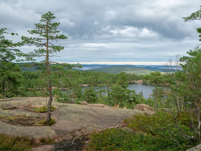
Image by Petr Höga Kustenleden is a 135 km coastal-and-forest trek through Sweden’s UNESCO-listed High Coast, running north from Hornöberget beside Högakustenbron to Örnsköldsvik. It suits self-reliant walkers who want a wild-feeling route without technical climbing, with orange waymarks, forest paths, granite tops and regular contact with the Gulf of Bothnia.
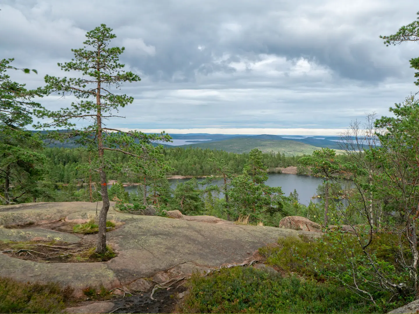
The trail’s character comes from land still rising after the last Ice Age. You cross boulder fields, raised cobble shores, old-growth forest, sandy bays and open rock, with wide sea views over the High Coast archipelago.
Skuleberget and Skuleskogen National Park are the scenic core, but the appeal is the constant change between coast, woodland, small settlements and bare stone. Free wind shelters, simple cabins and Sweden’s allemansrätten make low-cost camping practical for much of the route.
It is still a hard walk overall. The difficulty builds through repeated steep climbs and descents, rooty and rocky ground, long stages, summer mosquitoes and water sources that can be unreliable in dry spells.
This guide covers stages, timings, accommodation, food, transport, terrain and the common mistakes to avoid.
Stage-by-Stage Guide
Distances below follow the official 9-stage breakdown used by STF and the Höga Kusten tourism board. On the ground, the same route is also signposted as 13 shorter etapper, so place names such as Fjärdbotten, Skoved, Käl, Näske, Sandlågan, Svedje and Hörnett may appear between the official overnight points.
Stage 1: Hornöberget to Lövvik — 11 km
The trail starts at Hornöberget, beside Högakustenbron on the north side of the Ångermanälven river mouth. This is a short opening day by official-stage standards, but it immediately introduces the character of Höga Kustenleden: forest path, rocky ground, coastal viewpoints and orange waymarking rather than a smoothed-out walking track.
Expect uneven woodland walking with roots, stones and short steeper sections rather than technical terrain. The route leaves the bridge area and heads north towards Lövvik, with the scale of Högakustenbron and the Ångermanälven giving a strong sense of the coast-and-river landscape at the start.
Food and water should be carried from the start unless services have been arranged in advance. Streams and small water sources on this trail can be unreliable in dry spells, so do not plan the day around an unverified refill.
Hornöberget has free trailhead parking and road access via the High Coast Bridge. Local bus options near the southern end, including DinTur services, should be checked before travelling, especially if starting without a car.
Lövvik is the official stage end. Accommodation options along the trail are a mix of tent camping, vindskydd, simple open cabins and occasional serviced accommodation, but shelter space is first-come, first-served and should not be treated as guaranteed. Carry camping gear if relying on low-cost overnight stops.
Navigation is straightforward in principle: follow the orange markings and avoid being pulled onto local tracks around the start area. The main practical warning is underfoot rather than navigational — wet roots and granite can be slippery, and mosquitoes can be persistent in high summer.
Stage 2: Lövvik to Gavik — 27 km
This is the longest official stage on Höga Kustenleden and needs to be treated as a full day, even by fit walkers. The distance alone makes it demanding, and the cumulative effect of rooty forest, rocky surfaces, cobble-like ground and short climbs can make progress slower than a map distance suggests.
The route continues north through the High Coast landscape, with Fjärdbotten one of the intermediate places on the longer official stage. Expect a mixture of forest singletrack, gravel forestry road, occasional road sections and rougher natural surfaces.
Views come and go rather than staying constant. Forested sections are broken by coastal openings, raised shorelines and the post-glacial terrain that defines the World Heritage area.
Carry a full day of food and more water than the map might imply. This is not a stage where it is sensible to rely on finding an open shop, café or dependable stream en route. Water availability should be checked before travelling, and treatment is sensible for natural sources.
Gavik is the official stage end. As elsewhere, overnight planning should be based on confirmed accommodation, a tent, or use of first-come vindskydd/open cabins where available. Do not assume that a free shelter will have space, especially in the main summer season.
Road access exists around the settlements, but public transport for intermediate starts or exits should be planned with current DinTur information rather than assumed. If splitting the stage, Fjärdbotten is the obvious intermediate place name to use when checking maps and access.
Navigation remains by orange markers, but the length of the day leaves less margin for mistakes. Start early, keep an eye on pace, and avoid pushing this stage late into the evening if carrying a heavy pack or walking in wet weather.
Stage 3: Gavik to Lappudden — 9 km
This is one of the shortest official stages and is a useful recovery day after the long Lövvik–Gavik section. It still has the High Coast mix of forest, rocky ground and shoreline influence, but the short distance gives more time for breaks and slower going on uneven surfaces.
The stage leads towards Lappudden in the Nordingrå area, a classic part of the High Coast peninsula known for red Nordingrå granite, small settlements and coastal inlets. Lappudden itself is associated with Lappuddens Friluftscenter on the shore of the bay.
The walking is not alpine, but do not expect a flat promenade. Roots, rocks, wet patches and occasional boardwalk-style terrain are all part of the route’s general character, and surfaces can be awkward when wet.
Carry food for the stage unless using pre-arranged services at Lappudden. The short distance reduces water pressure, but natural water sources still need caution in dry spells and should be treated where appropriate.
Lappudden is one of the more practical official stopping points because of the outdoor centre, but accommodation and food arrangements should be booked or checked ahead. Camping remains the most flexible backup for walkers carrying a tent.
Road access around Nordingrå and Lappudden makes this a more manageable stage for section-walkers than the more remote forest stretches, but current bus options should be checked before relying on them.
Stage 4: Lappudden to Ullånger — 15 km
This is a moderate official stage linking the Nordingrå area with Ullånger. It is long enough to feel like a proper day, but far shorter than the main endurance stages, making it a useful place to regain time if the earlier long day was split.
The terrain remains varied: forest paths, local tracks, rocky sections and some settlement approach walking. Around Nordingrå, expect the landscape to feel more open in places, with small communities and coastal water never far from the wider route corridor.
The main landmarks are Lappudden at the start and Ullånger at the finish. This stage is less about one major headline sight and more about linking the peninsula landscape into the central section of the trail.
Food and water should still be planned conservatively. Ullånger is a named town on the trail and a sensible place to check for resupply, meals or accommodation, but opening times and exact services should be checked before travelling.
Accommodation at or near Ullånger may include guesthouse, hotel or hostel-style options in the wider High Coast trail network, alongside camping. Do not rely on free shelters alone unless carrying a tent as backup.
Navigation is usually simple with the orange markings, but extra attention is needed where the trail uses local roads, tracks or settlement edges. Road walking on the High Coast Trail is generally short, but stay alert to traffic where the route joins asphalt.
Stage 5: Ullånger to Skuleberget — 21 km
This is one of the key stages of the whole route, finishing at Skuleberget, the recognised high point of Höga Kustenleden at 286 m. It is also a substantial walking day: the distance is significant, and the climb to the trail’s highest ground comes after many kilometres already underfoot.
The route passes through the central High Coast landscape, with Skoved and Docksta among the intermediate places on the way to Skuleberget. Expect a mix of forest, local tracks, rocky ground and steeper climbing as the terrain builds towards the mountain.
Skuleberget is important geologically as the level of the world’s highest measured post-glacial coastline. From the summit area there are wide views over the Gulf of Bothnia and the High Coast archipelago, with the raised-landscape story visible in the stepped landforms below.
Below Skuleberget are Kungsgrottan, the King’s Cave, and Naturum Höga Kusten at the base off the trail. Naturum is useful for understanding the land uplift and World Heritage landscape, but opening times and any services should be checked before building a plan around it.
Carry enough food and water for a long, strenuous day. Docksta and the Skuleberget area may be useful planning points, but do not assume that food, water or indoor waiting space will be available at the exact time needed unless checked in advance.
Accommodation near the end needs planning. The broader trail has serviced hostels and guesthouses in or near towns, plus camping and simple shelters, but Skuleberget is a popular area and first-come options cannot be guaranteed.
Navigation is generally helped by the prominence of Skuleberget, but follow the orange route rather than cutting across local paths or access tracks. The main hazards are slippery granite in rain, exposed open rock in poor weather, and tired legs on the descent or final approach.
Stage 6: Skuleberget to Skuleskogen South Entrance / Entré Syd — 11 km
This shorter stage links Skuleberget with the southern entrance of Skuleskogen National Park. It is often used as a positioning day before the national park crossing, and its modest distance is useful after the harder Ullånger–Skuleberget stage.
The terrain remains rougher than the distance suggests. Expect forest path, rock, roots, possible wet sections and the general High Coast pattern of short climbs and descents rather than sustained easy cruising.
The main planning landmark is Entré Syd, the southern entrance to Skuleskogen National Park. The landscape becomes increasingly focused on the protected old-growth coastal forest, granite heights and raised shorelines that make the park the scenic core of the route.
Carry food for the whole day and enough water to reach the entrance area without relying on unverified streams. If planning to camp in or near the national park, check current rules before travelling.
Inside Skuleskogen National Park, camping is stricter than on most of the trail. In the main season, roughly 1 May to 30 September, tents are limited to designated sites, stays are limited to about three nights, fires are allowed only at provided fire sites using provided wood, and dogs must be on a lead.
Accommodation at this point is best planned around camping or a pre-arranged off-route stay. Do not assume that a wind shelter or open cabin will be empty on arrival.
Road access to the entrance area makes it a possible section start or finish, but public transport should be checked with current local timetables. Navigation into the park should be treated carefully, as national park paths, visitor routes and the through-trail may intersect.
Stage 7: Skuleskogen South Entrance / Entré Syd to Skuleskogen North Entrance / Entré Nord — 8 km
This is the shortest official stage but one of the most important. It crosses Skuleskogen National Park, established in 1984 and covering about 30 km² of old-growth coastal forest, granite mountains and raised cobble shores.
Do not underestimate the day because of the distance. The park has rocky, rooty and uneven ground, with steep sections, granite slabs and boulder-field terrain that can slow progress, especially with a full pack or in wet conditions.
The headline feature is Slåttdalsskrevan, the dramatic granite crevice in Slåttdalsberget, roughly 200 m long and 40 m deep. The path through the crevice has been closed since 2023 for rockfall safety; it is now viewed and bypassed from the rim and ends. Current diversion information should be checked before travelling.
The park section also gives access to the coastal character of Skuleskogen, including raised shorelines and the Tärnättholmarna area, where former islands have been joined to the mainland by land uplift. Smooth rocks, sea views and simple overnight cabins make this one of the most memorable parts of the trail, but facilities remain basic.
Food should be carried, and water should be treated or planned carefully. Natural water availability varies, and dry spells can make small sources unreliable.
Camping and overnight stays must follow national park rules. Use designated tent areas where required, use fire sites only as permitted, and do not assume cabins or shelters will have space.
Navigation needs more care here than on some other stages because of intersecting national park paths, visitor routes and Slåttdalsskrevan diversions. Follow official signs and orange trail markings, and allow enough daylight for slow rocky ground rather than treating 8 km as a quick stroll.
Stage 8: Skuleskogen North Entrance / Entré Nord to Balesudden / Köpmanholmen area — 20 km
This is a long post-park stage leading north from Entré Nord towards the Balesudden and Köpmanholmen area. After the intensity of Skuleskogen, the route continues through a mix of forest, coast-influenced terrain and settlements, with Käl, Näske and Köpmanholmen among the important intermediate place names.
The walking remains typical of Höga Kustenleden: forest singletrack, gravel roads, occasional asphalt, rocky ground and uneven coastal surfaces. The cumulative fatigue from previous stages often makes this 20 km feel harder than it looks on paper.
Views continue to alternate between enclosed forest and openings towards the Gulf of Bothnia. The wider archipelago setting is part of the appeal in this northern half, and summer passenger boats link parts of the coast with islands such as Högbonden, Ulvön and Trysunda, although schedules are seasonal and should be checked before relying on them.
Carry a full day of food. Köpmanholmen is a useful settlement name for checking services, access and accommodation, but specific food availability, opening hours and water points should be checked before travelling.
Accommodation in the Balesudden / Köpmanholmen area should be arranged in advance unless camping. As with the rest of the trail, vindskydd and simple cabins are useful but first-come, first-served; a tent gives far more control over the itinerary.
Road access improves around settlements such as Näske and Köpmanholmen, making this a possible section-walking point. Local bus options should be checked with current DinTur timetables.
Navigation can become more intricate around settlements, forestry tracks and road crossings. Keep following the orange waymarks rather than assuming the most obvious track is the trail.
Stage 9: Balesudden / Köpmanholmen area to Örnsköldsvik — 19 km
The final official stage is still a real walking day, not just an urban approach. It leads north towards Örnsköldsvik, passing the later-route place names Sandlågan, Svedje and Hörnett before finishing at Varvsberget and the central park area, Stadsträdgården.
Expect a mixed day underfoot. Forest paths, tracks and rocky sections gradually give way to more settlement-edge walking as the route approaches the city, with some road or asphalt stretches likely near the finish.
The main highlight is the transition from the quieter High Coast trail corridor into Örnsköldsvik, with a final elevated finish at Varvsberget. On clear days, the last high ground gives a satisfying sense of the route’s northern end and the coastal landscape behind.
Carry food and water for most of the day rather than assuming early city services. Once in Örnsköldsvik, full town amenities are available, making it the most reliable resupply and recovery point on the trail.
Accommodation is easiest to arrange at the finish compared with most other stages. Örnsköldsvik has full town services plus onward train, bus and airport links, including SJ rail connections and regional airport access; times and connections should be checked before booking tight onward travel.
Navigation on the final approach needs attention where paths, local roads and urban routes intersect. Continue following the orange markings to the official finish rather than ending the walk at the first road into town.
The main warnings are ordinary but important: tired legs on hard surfaces, route-finding distractions near the city, and the temptation to under-carry water because the finish feels close. Treat the last 19 km as a full stage until the trail actually reaches Örnsköldsvik.
Recommended Itinerary
The most practical default plan is the official 9-day breakdown used by STF and the Höga Kusten tourism board. It keeps the longer sections manageable, gives enough time for Skuleberget and Skuleskogen National Park, and avoids relying too heavily on uncertain intermediate accommodation.
Published stage counts vary: the same route is also signposted on the ground as 13 shorter etapper. If booking fixed accommodation rather than carrying a tent, check official mapping before booking, especially around the longer Lövvik–Gavik and Entré Nord–Balesudden/Köpmanholmen sections.
Standard 9-day itinerary
| Day | From | To | Approx. distance | Why this stage makes sense | Services/accommodation notes |
|---|---|---|---|---|---|
| 1 | Hornöberget | Lövvik | 11 km | A short first day from the trailhead beside Högakustenbron, useful if arriving by bus, coach or car the same day. It also gives time to settle into the orange waymarking and the mixed forest/coast terrain. | Free trailhead parking is available at Hornöberget. Accommodation and camping options beyond the start should be checked before travelling; carrying camping gear gives the most flexibility. |
| 2 | Lövvik | Gavik | 27 km | This is the longest official stage and should be treated as a full walking day. Expect a more committing section where water, food and overnight plans need to be sorted before leaving Lövvik. | Fjärdbotten is an intermediate point on the 13-etapp version and may help slower walkers split the day. Do not rely on services or shelter space without checking current information. |
| 3 | Gavik | Lappudden | 9 km | A deliberately short recovery day after the long Lövvik–Gavik section. It brings the route into the Nordingrå/Lappudden area, one of the more useful places to pause before continuing north. | Lappudden has an outdoor centre on the shore. Check current accommodation, camping and food arrangements before booking this as a fixed overnight. |
| 4 | Lappudden | Ullånger | 15 km | A moderate linking day that keeps the itinerary balanced before the longer approach to Skuleberget. It is a sensible point to reassess food, weather and onward accommodation plans. | Ullånger is one of the named settlements on the route. Treat it as a planning checkpoint, but check exact services and opening times before relying on them. |
| 5 | Ullånger | Skuleberget | 21 km | A substantial day with the route’s recognised high point at Skuleberget, 286 m. Allow time for steep and rocky ground, viewpoints over the Gulf of Bothnia, and slower progress on granite and roots. | Skoved and Docksta are intermediate places before Skuleberget. Naturum Höga Kusten is off the trail at the base of Skuleberget; check opening times if planning to use it. |
| 6 | Skuleberget | Skuleskogen South Entrance / Entré Syd | 11 km | A shorter day after Skuleberget, positioning you at the southern side of Skuleskogen National Park without rushing into the park late in the day. | Before entering Skuleskogen, check current national park camping rules and any route diversions. In season, camping is restricted to designated sites. |
| 7 | Skuleskogen South Entrance / Entré Syd | Skuleskogen North Entrance / Entré Nord | 8 km | Short in distance but important in terrain: this is the scenic core through Skuleskogen, with rough coastal forest, granite and raised shorelines. Do not judge the day by kilometres alone. | If staying inside the park, use designated camping areas or permitted cabins only. The path through Slåttdalsskrevan has been closed since 2023 for rockfall safety; check the current bypass and viewing arrangements before travelling. |
| 8 | Skuleskogen North Entrance / Entré Nord | Balesudden / Köpmanholmen area | 20 km | A longer northern stage after leaving the national park, continuing through coastal and forest terrain towards the Köpmanholmen area. It is best started early, especially in wet weather or mosquito season. | Käl, Näske and Köpmanholmen are intermediate points on the wider route description. Accommodation and shelter options are irregular, so carry enough food and water margin for the day. |
| 9 | Balesudden / Köpmanholmen area | Örnsköldsvik | 19 km | A final full walking day into Örnsköldsvik, finishing at Varvsberget / Stadsträdgården. It is long enough to require a normal trail start, but ends with full town logistics. | The route passes through or near Sandlågan, Svedje and Hörnett before Örnsköldsvik. Örnsköldsvik has town amenities plus train, bus and airport links; check SJ, DinTur and airport schedules before fixing onward travel. |
Slower variant: 10–13 days
A slower itinerary suits hikers who want shorter days, families doing selected sections, anyone carrying a heavy camping load, or walkers who prefer more time in Skuleskogen and the Nordingrå peninsula. It is also the safer approach if using fixed accommodation, because the official 9-day version includes several long or awkwardly spaced stages.
The best places to add time are:
| Where to slow down | How to adapt the itinerary | Why it helps |
|---|---|---|
| Lövvik–Gavik | Split the long 27 km official stage using the 13-etapp structure, with Fjärdbotten as the key intermediate place to investigate. | This is the clearest improvement for most walkers, turning the hardest distance day into a more manageable section. Check official mapping before booking. |
| Gavik–Lappudden | Keep this as a short day rather than combining it. | It gives recovery time after the southern stages and leaves more margin for weather, mosquitoes and water planning. |
| Ullånger–Skuleberget | Consider breaking the approach around Skoved or Docksta if accommodation or camping plans allow. | The stage is 21 km and includes the climb to Skuleberget, so a split gives more time for the high point and surrounding viewpoints. |
| Skuleskogen National Park | Spend an extra night at a designated site or permitted cabin area, such as the coastal section around Tärnättholmarna if it fits the current rules and route plan. | Skuleskogen is the most rewarding part of the trail to walk slowly, but national park camping rules are stricter than elsewhere. Check current regulations before travelling. |
| Entré Nord–Balesudden / Köpmanholmen area | Use the intermediate places Käl, Näske and Köpmanholmen to plan a shorter day if suitable overnight options are available. | This reduces another 20 km stage and makes the northern end less rushed. Exact stopping points should be checked against current maps and accommodation availability. |
Faster variant: 6–7 days
A faster itinerary is only sensible for fit, self-reliant hikers carrying camping gear and comfortable with long days on roots, granite slabs, boulder fields and wet forest paths. It is much harder to make a fast schedule work with fixed accommodation, because the convenient overnight points do not always line up with even daily distances.
The cleanest way to compress the route is to combine the shortest official stages while using camping to avoid awkwardly long road-to-road days. In practice, that usually means combining Gavik–Lappudden with an adjacent day, and combining Skuleberget–Entré Syd with Entré Syd–Entré Nord if conditions in Skuleskogen allow.
An official-endpoint 7-day compression could look like this, but it includes one very long day and should not be treated as the default plan:
| Day | From | To | Approx. distance | Why this stage makes sense | Services/accommodation notes |
|---|---|---|---|---|---|
| 1 | Hornöberget | Lövvik | 11 km | A controlled start, useful if arrival logistics take part of the day. | Carry enough food to continue into the longer southern section. |
| 2 | Lövvik | Lappudden | 36 km | Combines the long Lövvik–Gavik stage with the short Gavik–Lappudden stage. This is a demanding day and only suits strong walkers in good conditions. | Do not plan this without checking water, camping and bailout options. Fjärdbotten and Gavik are the key intermediate planning points. |
| 3 | Lappudden | Ullånger | 15 km | A shorter recovery day after the longest push. | Use Ullånger as a practical point to review supplies and the weather forecast. |
| 4 | Ullånger | Skuleberget | 21 km | Keeps the Skuleberget climb as its own substantial day rather than rushing it. | Check options around Skoved, Docksta and Skuleberget before fixing the overnight. |
| 5 | Skuleberget | Skuleskogen North Entrance / Entré Nord | 19 km | Combines the approach to Skuleskogen with the short official crossing from Entré Syd to Entré Nord. It is efficient, but rougher than the distance suggests. | Check Skuleskogen camping rules and any Slåttdalsskrevan diversion before committing to this day. |
| 6 | Skuleskogen North Entrance / Entré Nord | Balesudden / Köpmanholmen area | 20 km | Maintains the official northern stage. | Shelter and accommodation spacing is irregular; camping gear is strongly advised. |
| 7 | Balesudden / Köpmanholmen area | Örnsköldsvik | 19 km | A final full day into the city, with reliable onward transport options once finished. | Book onward trains, buses or flights from Örnsköldsvik with enough margin for a late finish. |
A 6-day crossing is possible only as a fitness-focused backpacking schedule, not as the recommended plan. It requires long daily distances, flexible wild-camping outside restricted areas, and careful checking of water reliability in dry spells.
Planning the Route
Höga Kustenleden is straightforward to follow, but it is not a route to plan only by daily kilometre totals. The ground is often slow: roots, granite slabs, boulder fields, cobble shores and short steep climbs can make a moderate-looking stage feel longer than it appears on paper.
Most walkers should allow 7–9 days. The official structure is 9 hiking days, which gives the best margin for uneven terrain, swimming or rest stops on the coast, weather delays and the stricter camping rules in Skuleskogen National Park. Strong backpackers carrying camping gear often compress the route into 5–7 days, but that makes accommodation, water and food planning less forgiving.
Choosing a schedule
The official tourism-board and STF schedule divides the trail into 9 stages, while the ground signage also uses 13 shorter etapper on the same route. This is useful in practice: the 9-stage version works as a simple end-to-end plan, while the 13-etapp structure gives more intermediate stopping points such as Fjärdbotten, Skoved, Käl, Näske, Köpmanholmen, Sandlågan, Svedje and Hörnett.
A relaxed plan should avoid treating every day as equal. The longer official days include Lövvik–Gavik, Ullånger–Skuleberget, Skuleskogen North Entrance–Balesudden/Köpmanholmen area and the final approach to Örnsköldsvik. These are the days where an early start and a pre-planned overnight option matter most.
A faster 6–7 day itinerary is most realistic with a tent and the willingness to use wind shelters, simple open cabins or responsible wild camping. Relying only on serviced accommodation makes the route less flexible, because hostels, cabins and guesthouses are irregularly spaced rather than forming a continuous hut chain.
Direction of travel
The trail can be walked in either direction, but it is officially described south to north from Hornöberget by Högakustenbron to Örnsköldsvik. South-to-north planning has two advantages: it follows the official stage descriptions, and it finishes in the larger transport hub, with railway, bus and airport links at Örnsköldsvik.
North-to-south is still practical if transport works better that way. In that direction, take extra care with the final logistics at Hornöberget, as the start has parking and local access but not the same range of onward services as Örnsköldsvik.
Accommodation dictates the rhythm
This is not a hut-to-hut trail in the Alpine sense. Accommodation is flexible but uneven: free vindskydd wind shelters, simple open cabins and designated tent spots are useful, but they are first-come, first-served and not a substitute for carrying a shelter unless the whole itinerary has been planned around booked accommodation.
Serviced options include STF hostels and a small number of hotels or guesthouses in or near settlements, including places such as STF Allsta Gård, STF Kajkanten Höga Kusten, STF Pelle Åbergsgården, STF Skutskepparn and Högbonden lighthouse hostel. Availability, opening periods and prices should be checked before booking travel.
For most independent walkers, the safest planning model is to carry camping gear and treat indoor beds as a bonus or pre-booked comfort. This also makes it easier to shorten a long stage, stop before poor weather, or adapt if a shelter is already full.
Camping and permits
There is no permit system for walking Höga Kustenleden. Sweden’s allemansrätten — the right of public access — makes responsible wild camping practical along much of the route, provided camps are low-impact and away from private homes and sensitive ground.
The main exception is Skuleskogen National Park, where stricter rules apply. In the main hiking season, tents are restricted to designated sites, fires are only allowed at provided fire places with provided wood, and dogs must be on a lead. Current national park camping rules should be checked before travelling.
Food and water planning
Do not assume every village on the route has reliable resupply. The trail passes settlements such as Lövvik, Gavik, Lappudden, Ullånger, Docksta, Köpmanholmen and Örnsköldsvik, but opening hours and services can vary, especially outside peak summer.
Plan to carry food for multiple days at a time unless resupply has been checked in advance. This is particularly important if walking a fast schedule, camping between villages, or travelling in May, September or outside the busiest holiday period.
Water also needs active planning. Streams can be unreliable in dry spells, so start each day with enough capacity for the distance ahead and check current local advice before relying on smaller water sources. A treatment method is sensible for any natural water source.
Transport and section hiking
End-to-end logistics are manageable but should be fixed before accommodation is booked. Hornöberget is reached via the High Coast Bridge area, with free trailhead parking; public transport access normally involves rail or coach connections to the region and local DinTur buses. Örnsköldsvik is the simpler end for onward travel, with train, bus and airport links.
Current SJ, Ybuss and DinTur timetables should be checked before travelling. Local bus 50 runs near the southern end, but public transport is not frequent enough to treat every stage end as a guaranteed exit point without planning.
Section hiking is practical, especially around the more accessible villages and road-linked points, but it is not as simple as hopping on and off a frequent urban bus network. Build each section around confirmed transport first, then choose overnight stops.
Summer passenger boats can add side trips to islands such as Högbonden, Ulvön and Trysunda, but they should be treated as extensions rather than core trail logistics. Seasonal boat schedules should be checked before relying on them.
Shortening, extending and building in slack
The easiest way to shorten a full traverse is to use the intermediate etapp structure and finish at a transport-accessible settlement rather than forcing the whole route into a fixed number of days. Places such as Ullånger, Docksta, Köpmanholmen and Örnsköldsvik are more useful planning anchors than isolated shelter sites.
The most natural extensions are rest days or coastal side trips rather than extra trail distance. Skuleskogen, Skuleberget, the Nordingrå area and the island boats all justify extra time if the weather is good and services are running.
Build in at least some slack if travelling without a tent, during mosquito-heavy midsummer, or in unsettled weather. Wet granite, boulder fields and rooty forest paths can slow progress sharply.
Navigation and current route status
The trail is waymarked in orange and is generally clear, but a map or offline GPS track is still advisable. Forestry roads, boardwalks, rocky shorelines and forest paths can make junctions less obvious in poor visibility or fading light.
Published distances vary: the official figure is 135 km in 9 stages, while the same route is also described as roughly 128.6–131 km in 13 etapper. For planning, the difference matters less than the daily terrain and overnight options, but avoid building a schedule with no time margin.
Check current trail information before departure, especially in and around Slåttdalsskrevan. The path through the crevice has been closed since 2023 for rockfall safety, with the feature viewed or bypassed from the top and ends instead.
Towns, Villages and Overnight Stops
Höga Kustenleden is not a village-to-village inn trail. The practical pattern is a mix of booked serviced accommodation, free wind shelters, simple open cabins, designated tent sites and responsible wild camping under allemansrätten, with stricter rules inside Skuleskogen National Park.
Do not assume that every named stage point has a shop, café or bed. Outside Örnsköldsvik, accommodation and food availability should be checked before travelling, especially if planning a non-camping itinerary.
Serviced options in the wider trail corridor include STF hostels and guesthouses such as STF Allsta Gård, STF Kajkanten Höga Kusten, STF Pelle Åbergsgården, STF Skutskepparn and the Högbonden lighthouse hostel off the coast. Check exact location, opening period and current availability against the day-by-day itinerary before booking.
Hornöberget
Hornöberget is the official southern trailhead, beside Högakustenbron on the north shore of the Ångermanälven river mouth. It is mainly a start point rather than a natural overnight stop, although the free trailhead parking makes it practical for hikers being dropped off or leaving a car.
The route is waymarked in orange from here. For public transport, the usual approach is via Härnösand by SJ train and then a DinTur local bus, or by Ybuss coach; local bus 50 runs near the southern end. Timetables should be checked before travelling.
Lövvik
Lövvik is the first official stage end northbound, around 11 km from Hornöberget. It is a useful short first day if arriving late at the trailhead or easing into the route before the longer Lövvik–Gavik stage.
Treat Lövvik as a planned overnight point only if accommodation, camping or shelter arrangements have been checked in advance. Do not rely on it as a guaranteed resupply stop without current information.
Fjärdbotten
Fjärdbotten is one of the intermediate 13-etapp points on the same trail, sitting between Lövvik and Gavik. It is useful for breaking up the long official second stage, which is one of the tougher planning days on the route.
There is no continuous serviced hut chain on this section, so campers have the most flexibility. If using Fjärdbotten as an overnight or food stop, current facilities should be checked before travelling.
Gavik
Gavik is the official end of the long Lövvik–Gavik stage and the start of the shorter stage to Lappudden. For many hikers it is a logical place to stop after a full day, especially when carrying camping gear.
Accommodation and food options should not be assumed. Plan this section with enough food to continue if local services are closed or unavailable.
Lappudden
Lappudden sits in the Nordingrå area and is one of the more useful serviced stopping points on the southern half of the trail. Lappuddens Friluftscenter makes it a natural overnight candidate for hikers wanting a softer night between Gavik and Ullånger.
It is also a sensible place to pause if splitting the route into shorter sections around the Nordingrå peninsula. Bookable accommodation, food and any local transport options should be checked before travelling.
Ullånger
Ullånger is an official stage end and a key planning point before the climb towards Skuleberget. It is one of the named settlements where hikers commonly look to regroup, wash kit, recharge devices or adjust food carries.
Do not build a resupply plan around Ullånger without checking current shop and accommodation opening times. From here the next official stage to Skuleberget is a substantial day, so leaving with enough food and water capacity matters.
Skoved
Skoved is an intermediate point between Ullånger and Docksta/Skuleberget on the 13-etapp breakdown. It can be useful when dividing the longer official Ullånger–Skuleberget stage into a more conservative walking day.
Specific food, transport and bed options should be checked before relying on Skoved. Campers will have more freedom than hikers trying to link only booked accommodation.
Docksta
Docksta sits near the Skuleberget section and is one of the practical settlement names to know when arranging accommodation or transport around the middle of the route. It is a useful access point for hikers section-walking the High Coast Trail or joining/leaving near Skuleberget.
Food, cafés and accommodation in or near Docksta should be checked before travelling. The Naturum Höga Kusten visitor centre is off the trail at the base of Skuleberget, so allow time if adding it to the day.
Skuleberget
Skuleberget is an official stage end and the trail’s recognised high point area at 286 m. It is a major route landmark, but it should still be treated as a planned overnight rather than an assumed service stop.
The following section to Skuleskogen South Entrance is shorter on the official itinerary, but the terrain remains rocky and uneven. Confirm current accommodation, food, transport and any local facilities before committing to an overnight here.
Skuleskogen National Park — South Entrance / Entré Syd
Entré Syd is the southern entry point for the official Skuleskogen crossing and an official stage end. It is a useful place to time the route carefully, because national park camping rules are stricter than on most of Höga Kustenleden.
In season, tents are restricted to designated sites, stays are limited, fires are only allowed at provided fire sites with provided wood, and dogs must be on a lead. Current rules and any diversions, including around Slåttdalsskrevan, should be checked before travelling.
Skuleskogen National Park — North Entrance / Entré Nord
Entré Nord is the official end of the Skuleskogen crossing and the start of the longer stage towards the Balesudden/Köpmanholmen area. It works well as a boundary point for planning: south of it, national park restrictions apply; north of it, the route returns to the broader mix of forest, coast, shelters and camping options.
Do not assume serviced accommodation or food at the entrance itself. Carry enough supplies to continue beyond the park if shelters or tent sites are full.
Käl
Käl is one of the intermediate 13-etapp points north of Skuleskogen. It is mainly useful as a route-splitting and navigation point rather than a guaranteed serviced stop.
If planning to overnight here, check current shelter, camping and accommodation options in advance. The section after Skuleskogen can feel committing if food or water assumptions prove wrong.
Näske
Näske lies on the northern half of the trail before the route continues towards the Köpmanholmen and Balesudden area. It is a useful named point for shortening the official Entré Nord–Balesudden stage.
Accommodation, food and transport details should be checked before travelling. Campers should still carry enough food to bypass the stop if necessary.
Köpmanholmen
Köpmanholmen is part of the practical Balesudden/Köpmanholmen area used in the official northbound staging before the final push to Örnsköldsvik. It is one of the more important names on the northern part of the trail for section hikers and anyone arranging a pickup, overnight or exit point.
The coast in this wider area is also relevant for summer passenger boats to offshore High Coast islands such as Högbonden, Ulvön and Trysunda, although boat schedules are seasonal and should be checked before relying on them. Högbonden lighthouse hostel is an off-route option, not a standard on-trail stage stop.
Sandlågan
Sandlågan is an intermediate point between the Köpmanholmen area and Örnsköldsvik. It is useful for breaking up the final official stage if the full distance into the city is too long after previous days.
Treat it as a planning point rather than a guaranteed resupply stop. Check any accommodation, shelter or transport options before building an itinerary around it.
Svedje
Svedje is another intermediate northern point on the approach to Örnsköldsvik. It can help with pacing the final day, particularly if the weather is poor or the previous stage has run long.
No specific food or accommodation facilities should be assumed. Most hikers will either continue towards Örnsköldsvik or use camping/shelter options where permitted and available.
Hörnett
Hörnett sits close to the finish side of the route before Örnsköldsvik. It is most useful as an approach marker and possible local access point rather than a destination in its own right.
For hikers leaving or joining the trail here, local DinTur bus options should be checked before travelling. If continuing to the finish, Örnsköldsvik has the stronger transport and service base.
Örnsköldsvik
Örnsköldsvik is the northern finish, with the trail ending at Varvsberget / the central park area around Stadsträdgården. It is the only place on the route where full town amenities can be assumed.
This is the best place for a final hotel or hostel night, proper resupply, onward transport and gear sorting after the walk. Örnsköldsvik has railway links, DinTur local buses and Örnsköldsvik Airport; SJ train times, bus connections and flights should be checked before booking fixed onward travel.
Getting to the Start
Höga Kustenleden officially starts at Hornöberget, on the north shore of the Ångermanälven river mouth beside Högakustenbron, the High Coast Bridge. The trailhead has free parking and the route is waymarked in orange from the start.
Public transport access is workable, but it needs planning: the final leg to Hornöberget depends on current regional bus times or a pre-booked taxi. Check SJ, Ybuss and DinTur timetables before building a same-day arrival-and-hike plan.
By train
The practical rail approach is to take an SJ train to Härnösand, then continue by local DinTur bus towards the southern end of the trail. From Stockholm, this is the main train-based route into the area.
Do not assume a seamless connection from train to trailhead, particularly outside the main summer season or late in the day. Bus times, stop locations and the walking distance from the nearest stop to Hornöberget should be checked before travelling.
Örnsköldsvik, at the northern end of the trail, also has an SJ railway station with trains to and from Stockholm and Sundsvall. This is useful for the end of a south-to-north hike, or for walkers arranging a return to a car left at Hornöberget.
By bus
Ybuss operates direct coach links from Stockholm to the High Coast area, while DinTur runs local and regional buses in Västernorrland. Local bus 50 runs near the southern end of Höga Kustenleden and may be useful for reaching the Hornöberget area.
Exact bus stops, operating days and connections change, so this should be checked before travelling. If the onward bus does not line up with a train or coach arrival, pre-booking a taxi for the final leg is the safer option.
A taxi is most relevant for evening arrivals, early or late season starts, or groups splitting the fare. Do not rely on finding a taxi waiting at the trailhead.
By car
Drivers should head for Hornöberget beside Högakustenbron, over the Ångermanälven. Free trailhead parking is available at the start.
The main issue is that Höga Kustenleden is a point-to-point trail. Leaving a car at Hornöberget means arranging a return from Örnsköldsvik after the hike, usually by train, bus or taxi combination.
Although the trailhead parking is free, any current restrictions or suitability for leaving a vehicle for the full hike should be checked before travelling.
From the nearest airport
The useful regional airport for the route is Örnsköldsvik Airport (OER), at the northern end rather than the official start. For a south-to-north walk from Hornöberget, flying into Örnsköldsvik usually means arranging onward travel by train, bus and/or taxi to the start, or choosing to walk the trail north-to-south instead.
If arriving in Sweden via Stockholm, the simplest onward options are the SJ train towards Härnösand with a DinTur connection, or a Ybuss coach towards the High Coast area. Flight schedules and ground transfers should be checked before booking tight connections.
Where to stay before starting
Hornöberget should be treated as a trailhead, not a full resupply base. If arriving by public transport, the lowest-risk plan is to stay somewhere with reliable onward access to the start the following morning, then take a bus or pre-booked taxi to Hornöberget.
If starting immediately, the first official stage is the relatively short Hornöberget to Lövvik section. This makes a same-day start possible if arrival times are early enough, but avoid committing to it unless the final connection to the trailhead is secure.
The wider High Coast area has STF hostels, guesthouses and hotels, but accommodation is not continuous at every stage and should be booked ahead where it forms part of the plan. Campers can also use Sweden’s allemansrätten, the right of public access, where responsible wild camping is permitted, but do not rely on finding a suitable pitch at the trailhead after dark.
Getting Home from the Finish
Höga Kustenleden finishes in Örnsköldsvik, at Varvsberget / the central park area around Stadsträdgården. This is one of the easiest parts of the route logistically: unlike many intermediate trail points, the finish is in a city with rail, bus, taxi, accommodation and airport links.
By train
Örnsköldsvik has its own railway station, making train the simplest onward option for most walkers. SJ trains connect Örnsköldsvik with Stockholm and Sundsvall, so it is practical to finish the trail and continue south by rail if the timetable lines up.
Train times should be checked before travelling, especially if aiming to leave on the same day as the final stage. Build in margin for the walk down from Varvsberget, food, collecting any left luggage and the possibility of a slower final day after several days on rough ground.
By bus
DinTur local buses serve Örnsköldsvik and the wider Västernorrland area. They can be useful for regional movements or for linking with other transport, but do not assume there will be a convenient late-day service from the finish without checking the current timetable.
If retrieving a vehicle left at the start at Hornöberget by Högakustenbron, plan this connection before starting the hike. It may require a combination of train, regional bus and local taxi rather than a simple direct journey. This should be checked before travelling.
By car/taxi
Örnsköldsvik is a practical pick-up point because the trail ends in the city rather than at a remote trailhead. A pre-arranged lift or taxi is usually more straightforward here than at the smaller settlements and national park entrances earlier on the route.
If finishing late, tired or in poor weather, using a taxi from the central finish area to accommodation, the station or the airport may be the most sensible option. Taxi availability and fares should be checked locally before relying on this, particularly outside normal daytime hours.
From the nearest airport
Örnsköldsvik Airport (OER) is the nearest airport to the finish. It gives the trail a useful fly-out option, but flight schedules and ground transport between the city and airport are timetable-dependent and should be checked before booking a same-day departure.
For international journeys, many hikers will still find it simpler to connect onward by train towards larger transport hubs. Compare the train and flight timings before committing, especially if the final hiking day ends in the afternoon or evening.
Where to stay at the finish
Staying overnight in Örnsköldsvik is often the safest plan, particularly after a 6–9 day itinerary where the final stage length, weather and cumulative fatigue can make arrival time uncertain. The city has full amenities, so it is a good place to shower, eat properly, dry gear and travel onward the next morning.
Book accommodation in advance in the main summer walking season. If planning a same-day train, bus or flight connection, choose a flexible ticket where possible and leave enough time between reaching Varvsberget and the departure.
Which Direction Should You Walk?
The standard direction for Höga Kustenleden is south to north, from Hornöberget by Högakustenbron to Örnsköldsvik. This is the direction used by the official 9-stage description and is the simplest way to follow the route as packaged by STF and the Höga Kusten tourism board.
The trail is waymarked in orange and can be walked either way. There is no technical reason to avoid the reverse direction, but it does change the logistics and the feel of the walk.
South to north: Hornöberget to Örnsköldsvik
This is the best default choice for most walkers. You start at the High Coast Bridge, move through the smaller coastal and forest settlements of the southern half, cross the Nordingrå area, then reach the major scenic core around Skuleberget and Skuleskogen National Park before finishing in a proper town.
The biggest practical advantage is the finish. Örnsköldsvik has full town amenities, a railway station, bus links and a regional airport, so it is a much easier place to end a multi-day hike, shower, eat properly and travel onward. If using public transport, it usually makes sense to deal with the more limited trailhead access at Hornöberget at the start, rather than when tired at the end.
The official stage flow also works south to north. The route’s long second stage, Lövvik to Gavik, comes early, while the most celebrated sections around Skuleberget, Slåttdalsskrevan and Skuleskogen arrive after several days of building trail rhythm.
The main downside is that the route does not finish in wilderness. The final approach leads into Örnsköldsvik, which is practical rather than remote, though ending at Varvsberget gives a clear northern endpoint and immediate access to services.
North to south: Örnsköldsvik to Hornöberget
Walking north to south can work well if transport, accommodation or a parked car makes it more convenient. It is particularly logical if a vehicle is left at Hornöberget, where there is free trailhead parking, because the walk then ends at the car rather than requiring a transfer back from Örnsköldsvik.
The reverse direction gives a different psychological shape. You begin with the security of a city start, then quickly move into the wilder northern and central sections. The major scenery around Skuleskogen National Park and Skuleberget comes relatively early, rather than forming the mid-route climax.
The trade-off is the finish. Hornöberget is a dramatic trailhead beside Högakustenbron, but it does not offer the same range of onward transport and end-of-walk services as Örnsköldsvik. Bus and coach connections should be checked before travelling, especially if relying on DinTur, Ybuss or a timed connection to SJ trains.
Climbing and walking difficulty by direction
There is no clear climbing advantage either way. Höga Kustenleden is hard because of its cumulative terrain: repeated short climbs and descents, rooty forest path, granite slabs, boulder fields and cobble shores. Reversing the route changes which slopes are ascents and which are descents, but it does not remove the main difficulty.
For many hikers, descending wet granite, roots or loose rocky ground can be as demanding as climbing it. Trekking poles are useful in either direction, especially with a full camping pack.
Accommodation and stage planning
South to north is easier to plan because it follows the official 9-stage structure from Hornöberget to Örnsköldsvik. Reverse walkers can use the same stages in the opposite order, but need to check overnight spacing carefully rather than assuming every day will naturally finish at the most convenient shelter, cabin, campsite or settlement.
Accommodation on this trail is flexible rather than guaranteed. Free wind shelters and simple open cabins are first-come, first-served and irregularly spaced, so most walkers should carry camping gear whichever direction they choose. Inside Skuleskogen National Park, camping rules are stricter and designated camping areas must be planned around.
Weather and wind
There is no reliable direction advantage for weather. The route mixes forest, coast, open granite and exposed cobble shore, and wet conditions can make the harder ground slow in either direction.
In summer, long daylight helps with late finishes, but mosquitoes can be a significant nuisance. In early autumn, fewer insects and cooler conditions can make either direction more comfortable.
Recommendation
For most hikers, walk south to north, from Hornöberget to Örnsköldsvik. It matches the official stage descriptions, gives a strong progression through the High Coast landscape, and ends in the easiest place for food, accommodation and onward travel.
Choose north to south only if it solves a specific logistical problem — especially finishing at a car parked at Hornöberget — or if starting in Örnsköldsvik gives better transport connections for your itinerary. Current SJ, Ybuss and DinTur times should be checked before booking around either direction.
Accommodation Along the Route
Höga Kustenleden is best planned as a camping-first trail with occasional serviced nights, not as a classic inn-to-inn route. The strongest accommodation security comes from carrying a tent or other sleep system, because the free shelters and simple cabins are irregularly spaced and are first-come, first-served.
Serviced accommodation exists in and near some settlements, including STF hostels and a few hotels or guesthouses, but there is not a continuous chain at every stage end. Places such as Lappudden, Ullånger, Docksta/Skuleberget and Örnsköldsvik are the most useful planning anchors; the smaller intermediate villages are better treated as resupply, access or camping points unless accommodation has been booked in advance.
Inside Skuleskogen National Park, camping is more controlled than on the rest of the route. In season, tents are restricted to designated sites, with limits on length of stay and fires only at provided fire sites; check current national park rules before setting an itinerary through this section.
How accommodation works on Höga Kustenleden
There are four practical overnight styles on this trail:
- Wild camping under allemansrätten: viable on much of the route, provided it is done responsibly and outside restricted areas.
- Vindskydd and simple open cabins: useful, free or low-cost-feeling trail infrastructure, but not bookable and not guaranteed to have space.
- Designated campsites and outdoor centres: most useful around known stopping points such as Lappudden and within Skuleskogen where rules are stricter.
- Hostels, guesthouses and hotels: available in selected places only, including STF options such as STF Allsta Gård, STF Kajkanten Höga Kusten, STF Pelle Åbergsgården, STF Skutskepparn and the Högbonden lighthouse hostel.
Most independent hikers should carry enough camping gear to be self-sufficient for at least one awkward night. This is especially important on the longer official stages, such as Lövvik–Gavik and Ullånger–Skuleberget, where relying on a specific bed without a booking can make the day unnecessarily fragile.
Accommodation by place
| Place | Accommodation level | Best for | Notes |
|---|---|---|---|
| Hornöberget | Limited | Trailhead logistics | The start has free trailhead parking beside Högakustenbron. Do not assume meaningful accommodation choice at the actual trailhead. |
| Lövvik | Limited | First-night stop on the official 9-stage itinerary | Treat as a small-stage stop rather than a major accommodation hub. Book anything serviced before relying on it. |
| Fjärdbotten | Limited / none | Intermediate break or flexible camping plans | One of the shorter signed etapp points rather than a main serviced base. This should be checked before travelling. |
| Gavik | Limited | Breaking up the long southern section | Official stage end after the long Lövvik–Gavik day. Carrying camping gear gives much more flexibility here. |
| Lappudden / Nordingrå | Good | Softer night, camping, outdoor-centre facilities | Lappuddens Friluftscenter is one of the more useful accommodation anchors on the route and a logical place to plan a serviced or semi-serviced stop. |
| Ullånger | Good / limited | Resupply-style stop, bed night, route reset | One of the better settlement stops before the Skuleberget and Skuleskogen section. Book ahead in the main walking season. |
| Skoved | Limited / none | Intermediate waypoint | Better treated as a route point than a guaranteed overnight base. This should be checked before travelling. |
| Docksta | Good / limited | Access to Skuleberget area and serviced accommodation nearby | A practical base around the Skuleberget section, though accommodation choice should be checked and booked early in summer. |
| Skuleberget | Limited | Camping or nearby booked accommodation | The official stage ends at Skuleberget, but walkers wanting a bed may need to use accommodation in the wider Docksta/Skuleberget area. |
| Skuleskogen South Entrance / Entré Syd | Limited | National park entry, designated camping planning | Not a normal inn-to-inn stop. Plan around national park camping rules and available designated sites or simple shelters/cabins. |
| Skuleskogen North Entrance / Entré Nord | Limited | Exit from Skuleskogen, flexible camping | Similar to Entré Syd: useful as a stage end, but not a serviced accommodation hub. Check current park rules before travelling. |
| Tärnättholmarna | Limited | Simple cabin or coastal camping within Skuleskogen | Known for overnight cabins by the sea, but these should be treated as first-come, simple facilities rather than guaranteed accommodation. |
| Käl | Limited / none | Intermediate waypoint | One of the shorter signed etapp points north of Skuleskogen. Do not rely on accommodation without checking. |
| Näske | Limited / none | Intermediate waypoint | Better for flexible itineraries than fixed bed-to-bed planning unless accommodation has been arranged. |
| Köpmanholmen / Balesudden area | Limited | Final southern approach to Örnsköldsvik, camping or booked bed | The official itinerary uses the Balesudden/Köpmanholmen area before the final day. Accommodation should be checked before building a fixed itinerary around it. |
| Sandlågan | Limited / none | Intermediate waypoint | Treat as a route point rather than a main accommodation stop. This should be checked before travelling. |
| Svedje | Limited / none | Intermediate waypoint | Useful for route planning, but not a place to assume serviced accommodation. |
| Hörnett | Limited | Approach to Örnsköldsvik | Close enough to the final urban section to be useful, but most walkers will continue to Örnsköldsvik for full services. |
| Örnsköldsvik | Good | Finish night, transport connections, recovery | The best accommodation choice on the route, with full town amenities plus train, bus and airport links. |
Booking strategy
For a camping-based itinerary, bookings are less critical, but a tent remains important because shelters and open cabins cannot be reserved. In high summer, weekends and holiday periods, assume that the easiest shelters and the best-positioned serviced accommodation may be busy.
For a mixed camping-and-hostel itinerary, book the key bed nights first, then shape the walking days around them. Lappudden, Ullånger, Docksta/Skuleberget and Örnsköldsvik are the most useful places to anchor this kind of plan.
For a mostly serviced itinerary, plan conservatively and expect gaps. This route can work for walkers who want occasional indoor nights, but it is not ideal as a pure inn-to-inn hike unless accommodation and transfers are arranged in advance.
Can luggage transfer or taxi transfers solve the gaps?
Do not assume a standard baggage-transfer system along Höga Kustenleden. Any luggage movement would need to be arranged directly with accommodation providers or local operators, and this should be checked before travelling.
Taxi or bus links may help shorten awkward sections or connect a stage end to a nearby bed, especially around the larger settlements and the Örnsköldsvik end. Timetables and local availability change, so confirm DinTur services, taxi availability and any accommodation pick-up options before relying on them.
Practical advice for shelters and camping
A free shelter or simple cabin should be treated as a bonus, not a guaranteed booking. Arrive with a plan B: a tent, enough food, and enough water capacity for dry spells.
Use established fire places where provided, follow local fire restrictions, and be particularly careful inside Skuleskogen National Park. In the national park, current camping and fire rules should be checked before travelling, especially between roughly May and September.
Mosquitoes can be significant in high summer, so a shelter without a bug net may not be as comfortable as it looks on paper. A tent inner, head net or reliable insect protection can make the difference between a usable wild camp and a poor night’s sleep.
Camping and Wild Camping
Höga Kustenleden is well suited to a camping-based trip. The route has free wind shelters (vindskydd), simple open overnight cabins and designated tent/camping spots along much of its length, but they are irregularly spaced and generally first-come, first-served. Most backpackers should still carry a tent or other reliable shelter rather than planning to sleep only in huts or shelters.
Sweden’s right of public access, allemansrätten, makes responsible wild camping practical on most of the trail outside protected or restricted areas. It is not a licence to camp anywhere: pitch discreetly, stay away from houses, gardens and cultivated land, avoid damaging vegetation, and leave no trace.
How camping works on this trail
| Section | Camping notes |
|---|---|
| Hornöberget to Gavik | A mix of forest, coast and small settlements. Wild camping is generally practical where the ground and land use allow it, but do not assume a shelter will appear exactly where needed. |
| Gavik to Lappudden and Ullånger | Useful for shorter stages and resupply-style planning, with settlements on or near the route. Choose pitches carefully around villages, shorelines and private property. |
| Ullånger to Skuleberget and Docksta area | More committing if carrying full camping gear, with rocky ground and repeated climbs. Plan the overnight before starting the longer Ullånger–Skuleberget stage. |
| Skuleskogen National Park | Stricter rules apply. In the main season, tents are allowed only at designated sites; use the marked camping areas and open cabins rather than informal pitches. |
| Skuleskogen to Köpmanholmen and Örnsköldsvik | Camping remains possible in suitable places, but the approach to Örnsköldsvik becomes more built-up. Avoid trying to wild camp close to the city, roads, homes or gardens. |
Wild camping and allemansrätten
Outside Skuleskogen National Park and other restricted land, allemansrätten normally allows a small tent for a short stay, provided it is done responsibly. On this route that usually means a low-impact forest or coastal pitch well away from homes, agricultural land and busy visitor spots.
Good pitches are not guaranteed. The High Coast terrain includes bare granite, rooty forest, boulder fields, cobble shores and wet ground, so a flat tent site can be harder to find than the map suggests. Start looking before dusk rather than assuming the next kilometre will be easier.
Do not camp on cultivated land, in gardens, beside occupied buildings, or anywhere signed against camping. If a location looks like private residential land or managed visitor infrastructure, move on or ask locally.
Skuleskogen National Park rules
Skuleskogen National Park is the main exception to the otherwise flexible camping style. During the main season, roughly 1 May to 30 September, tents are restricted to designated sites, with a maximum stay of about three nights. Fires are allowed only at provided fire sites and with provided wood, and dogs must be kept on a lead.
The trail crosses the park between Entré Syd and Entré Nord, so do not plan an informal wild camp inside the park. Tärnättholmarna has overnight cabins by the sea and is one of the key places to factor into a camping itinerary through this section, but spaces are not bookable in the way a hostel bed is. Current national park camping rules and any seasonal restrictions should be checked before travelling.
Shelters, cabins and tent sites
The free vindskydd and simple open cabins are a major advantage of Höga Kustenleden, especially in wet weather or during mosquito-heavy summer evenings. They should be treated as shared emergency-style facilities, not guaranteed accommodation. Arrive prepared to camp outside if they are full, occupied by day users or unsuitable.
Carry a sleeping mat even if planning to use shelters, as wooden sleeping platforms are hard and basic. A tent, tarp or bivvy also gives flexibility on the longer official stages, including Lövvik–Gavik and Ullånger–Skuleberget, where relying on a single planned stopping point can make the day unnecessarily rigid.
Water and camping logistics
Do not rely on every stream or small watercourse being usable. Streams can be unreliable in dry spells, which matters if camping away from settlements or shelters. Fill up when passing reliable services or known water points, and carry enough to cook and camp if the next section is dry.
Coastal scenery does not necessarily mean convenient drinking water. The route often runs near bays, beaches and the Gulf of Bothnia, but salt or brackish coastal water is not a practical drinking source. Plan water before committing to a remote pitch.
Fires, stoves and seasonal issues
Use a stove for cooking unless a proper fire site is provided and fires are currently permitted. In Skuleskogen, fires are restricted to provided fire places with provided wood. Elsewhere, local fire bans can apply in dry weather, and current fire-risk information should be checked before lighting any fire.
High summer brings long daylight but also peak mosquitoes, especially around damp forest, still water and sheltered camping spots. A head net, repellent and a tent with intact mesh are worth carrying. Early autumn is often quieter for insects, but colder nights make a warmer sleeping bag more important.
Leave No Trace on the High Coast
Pack out all rubbish, including food scraps, wipes and damaged gear. Use toilets where provided; otherwise camp well away from paths, water and visitor areas, and bury human waste responsibly where permitted.
Keep camps small and unobtrusive, avoid widening existing bare patches, and do not move stones or branches to build furniture or fire rings. The raised cobble beaches, granite slabs and old coastal forest are part of the World Heritage landscape, so the aim is to leave no visible sign of the night’s camp.
Food, Water and Resupply
Höga Kustenleden is not a continuous village-to-village resupply walk. It passes named settlements and serviced places, but long sections are forest, coast, cabins, wind shelters and small rural communities where food cannot be assumed.
Plan as a self-sufficient backpacking route unless accommodation, meals and opening times have been arranged in advance. Örnsköldsvik has full town amenities at the northern end; elsewhere, treat shops, cafés, petrol-station food and hostel meals as useful bonuses rather than guaranteed daily resupply.
Food planning
Carry enough food to cover the longer official stages, especially Lövvik–Gavik, Ullånger–Skuleberget, Entré Nord–Balesudden / Köpmanholmen area and the final approach to Örnsköldsvik. Several of these are around 19–27 km and pass through mixed forest, road, coastal and rocky terrain where progress can be slower than the map distance suggests.
A sensible approach is to start with at least two days of food, then use settlements such as Lappudden, Ullånger, Docksta, Köpmanholmen and Örnsköldsvik as planned or potential resupply points only after checking current services. Rural Swedish opening hours, Sunday trading and seasonal café/restaurant hours can be limited, particularly outside peak summer. This should be checked before travelling.
If using STF hostels, guesthouses or outdoor centres such as those in the High Coast area, check whether meals, packed lunches or self-catering food are available before relying on them. Free wind shelters and open cabins should be treated as overnight infrastructure only, not food stops.
Water planning
Water is a more important planning issue than the coastal setting may suggest. Streams and small sources can be unreliable in dry spells, and the route includes exposed granite, cobble shores and long forest sections where there may be no convenient tap for hours.
Fill bottles whenever leaving a settlement, accommodation, visitor facility or known tap. Natural water should be filtered, treated or boiled unless it is clearly from a safe tap or managed supply. Do not plan to use sea water as a drinking source.
For most stages, start with enough water for a full day’s walking. In cool weather many hikers will carry around 2 litres; in warm weather, on the longer stages, or when camping away from a reliable water point, carry more and top up whenever a safe source is available.
Section-by-section resupply notes
| Section | Food availability | Water availability | Notes |
|---|---|---|---|
| Hornöberget to Lövvik | Limited at the trailhead and on the short first stage unless arranged locally. | Start with a full carry from the trailhead area; natural sources should be treated. | Hornöberget is a trailhead with parking, not a guaranteed resupply point. Do not begin short on food or water. |
| Lövvik to Gavik | Treat as a low-resupply stage. | Carry enough for a long day; streams may be unreliable in dry spells. | This is one of the longest official stages, so food and water should be packed before setting off. |
| Gavik to Lappudden | Limited rural availability; services at or near Lappudden should be checked. | Refill where available at serviced accommodation or facilities; treat natural water. | A shorter stage, but do not assume café or shop opening without checking. |
| Lappudden to Ullånger | Possible resupply around Ullånger, but current shops and opening hours should be checked. | Fill before leaving Lappudden if possible; refill in Ullånger if services are open. | Useful point to reduce pack weight if reliable food access has been checked in advance. |
| Ullånger to Skuleberget | Food may be available in settlements or serviced places on/near the route, but should not be assumed. | Carry enough for the full stage; exposed granite and climbs can increase water needs. | This is a longer, hillier section. Start with food for the day and enough water to avoid relying on minor sources. |
| Skuleberget to Skuleskogen South Entrance | Limited once away from Skuleberget. | Fill before entering the national park area; treat natural water. | Check current facilities and national park information before relying on water or services. |
| Skuleskogen South Entrance to North Entrance | No reliable food resupply inside the park. | Carry water, and treat/boil any natural water used. | Camping rules are stricter in Skuleskogen; food should be packed for the park crossing and any overnight stop. |
| Skuleskogen North Entrance to Balesudden / Köpmanholmen area | Limited until reaching the Köpmanholmen area; check services before planning a meal stop. | Carry enough for a long day; natural sources should be treated. | A substantial stage with coastal and forest terrain. Pack food as though there is no mid-stage shop. |
| Balesudden / Köpmanholmen area to Örnsköldsvik | Food availability improves towards Örnsköldsvik. | Start with enough for the day, then use town amenities at the finish. | Örnsköldsvik has full town amenities, making it the most reliable resupply and end-of-hike food stop. |
Practical carry strategy
For a camping-based hike, carry breakfasts, evening meals and emergency food independently of cafés or hostels. Use village services to add fresh food, snacks and stove fuel only where current availability is certain.
For a hut, hostel or guesthouse-based itinerary, book ahead and ask specifically about evening meals, breakfast, packed lunches and nearby shops. A bed booking does not automatically solve food logistics on this trail.
In summer, carry extra water capacity for hot, still days and mosquito-heavy camps where cooking away from exposed water sources may be more comfortable. In early or late season, carry enough food to cover closed cafés and reduced rural services.
Terrain, Conditions and Difficulty in Practice
What the ground is like
Höga Kustenleden is not a high-altitude route, but it is rarely smooth for long. The main surfaces are forest singletrack, gravel forestry roads, short asphalt road sections, boardwalk over wetland, sandy beaches, wave-rounded cobble shores and bare granite tops.
The hardest underfoot sections are the rooty forest paths, boulder fields and raised cobble beaches created by post-glacial land uplift. These can be slow with a full pack, especially where the stones are rounded, loose or wet. Progress is often limited more by foot placement than by gradient.
The bare granite slabs and domes are a major part of the High Coast character. In dry weather they can be firm and enjoyable; in rain they can become slippery, particularly where lichen, pine needles or damp moss sit on the rock.
There is some easier walking on gravel roads and short asphalt stretches. These help average speed, but they do not remove the need for proper hiking footwear: the route repeatedly returns to uneven forest and rocky coast.
Why the route feels harder than its height suggests
The high point at Skuleberget is only 286 m, but the route’s difficulty comes from repetition. Expect many short, steep climbs and descents rather than one big mountain day.
Published ascent totals vary, so it is best treated as roughly 2,540–3,000 m across the full route rather than a single exact figure. That amount of climbing over 135 km is manageable for a fit backpacker, but it becomes tiring when combined with roots, rock, cobbles and long stages.
The official 9-stage itinerary includes one long stage of about 26.8 km between Lövvik and Gavik, plus several stages around 19–21 km. On this terrain, those distances should not be judged like road or easy woodland kilometres. A heavy pack, wet rock, mosquitoes or a dry-water detour can make a nominally moderate day feel much harder.
Rocky and exposed sections
There is no technical climbing on the trail, and the waymarking is in orange. However, the rocky sections demand concentration, especially on boulder fields, cobble shores and granite slabs.
The most exposed feeling comes on open granite tops and coastal viewpoints, where there is less shelter from wind, sun and rain. These sections are not alpine, but they are more committing than ordinary forest walking in poor weather because slips on wet rock are a real risk.
Skuleberget is the recognised high point of the trail and one of the steeper, more strenuous parts of the route. Skuleskogen National Park also contains some of the most rugged walking, with granite mountains, old-growth forest and raised shorelines.
Slåttdalsskrevan is a key landmark in Skuleskogen, but the path through the crevice has been closed since 2023 due to rockfall risk. The route is now viewed or bypassed from the top and ends; current diversions and access should be checked before travelling.
Wet, muddy and boggy ground
The route includes boardwalk over wetland, which helps on the softest ground but can be slippery when damp. Forest sections can also be muddy after rain, particularly where roots hold water and foot traffic has worn the path.
Höga Kustenleden is not primarily a bog route, but wet ground still affects pace and footwear choice. Waterproof boots or trail shoes with strong grip are more useful than lightweight road-running soles, especially if hiking in spring or after sustained rain.
Streams can be unreliable in dry spells. This affects difficulty in practice because carrying extra water adds pack weight, and water stops may take longer than expected. Water availability should be checked before travelling, particularly in high summer.
Road walking, forestry tracks and navigation
Expect some gravel forestry roads and short asphalt road sections between forest and coast. These are useful for covering distance and linking villages, but they are intermittent rather than the dominant character of the trail.
Navigation is generally straightforward because the route is waymarked in orange. The main practical issue is not route-finding complexity, but staying alert where the trail changes surface, meets roads, or passes through settlements and trailheads.
The trail is described officially in 9 day-stages, while ground signage also breaks the same route into 13 shorter etapper. This matters for planning because signs may refer to intermediate places such as Fjärdbotten, Skoved, Käl, Näske, Köpmanholmen, Sandlågan, Svedje and Hörnett rather than only the 9-stage endpoints.
Fields, fences and barriers
This is primarily a forest, coast, granite and village-linking trail, not a UK-style field-and-stile walk. Livestock fields, stiles and frequent gate systems are not a defining feature of the route.
The practical barriers to progress are more likely to be uneven ground, wet boardwalk, boulder fields, road crossings, seasonal services and national park rules than fences or farm navigation.
Seasonal conditions
The practical hiking season is roughly May to September. Outside that window, snow, ice and reduced services make the route a different proposition and winter walking is not the norm.
Spring can bring wet ground, colder conditions and lingering slipperiness on shaded rock or boardwalk. It can be a good time for strong walkers who want quieter trails, but accommodation, transport and service availability should be checked before relying on them.
Midsummer gives very long daylight, which helps on long stages and makes flexible wild-camp planning easier. The trade-off is peak mosquitoes, which can make forest camps, still evenings and low-lying wet areas significantly less comfortable.
High summer can also bring dry spells, making streams less reliable. Plan water carries conservatively and avoid assuming that every mapped or expected water source will be running.
Early autumn is often one of the most practical seasons for experienced walkers: fewer insects, cooler hiking temperatures and autumn colour. Daylight shortens, however, so long stages over rocky ground need earlier starts than in midsummer.
Difficulty in real-life planning terms
Höga Kustenleden is best treated as a hard multi-day backpacking route rather than a technically difficult mountain trail. The route is well waymarked and low in elevation, but it asks for steady fitness, secure footing and the ability to handle long, uneven days.
The full trail suits walkers who are comfortable carrying camping gear or linking simple shelters and accommodation without relying on a continuous hut chain. Because shelters and cabins are first-come, first-served and irregularly spaced, a tent gives a much safer margin.
The main factors that make the hike harder are wet rock, rooty forest, boulder and cobble sections, mosquitoes, long stages, pack weight and uncertain water in dry periods. The main factors that make it easier are the clear waymarking, low altitude, long summer daylight and the option to break the route using shorter signed etapper or nearby settlements.
Weather and Best Time to Walk
The practical hiking season for Höga Kustenleden is roughly May to September. Outside this window, snow, ice, short daylight and reduced services make the route a much more specialist undertaking rather than a normal long-distance walk.
For most hikers, the best balance is late summer to early autumn: the trail is generally more settled underfoot than in spring, insects are less of a problem than around midsummer, and the long forest and coast sections are still realistic as a multi-day backpack. Midsummer is also popular because daylight is exceptionally long, with near-midnight light, but mosquitoes are at their peak.
Month-by-month planning
| Period | What to expect | Practical advice |
|---|---|---|
| May | Start of the practical hiking season. Conditions can still feel early-season, especially in shaded forest and wet areas. | Check transport, accommodation and any trail updates before committing. Carry warm layers and do not assume all seasonal services are operating. |
| June to July | Long daylight and the easiest timing for long stages, but this is also the main mosquito period. | Bring proper insect protection, especially for camps, wind shelters and still forest sections. Book any serviced accommodation early if using hostels or guesthouses. |
| August | Often one of the most practical months for the full trail: still within the main season, with long-enough days and usually fewer insects than midsummer. | A strong choice for backpackers carrying a tent. Continue to treat water availability cautiously in dry spells. |
| September | Early autumn colour, fewer insects and a chance of seeing the northern lights. Days are shorter and nights are cooler. | Start stages early, carry warmer sleep gear, and check current service and transport availability before relying on it. |
| October to April | Not the normal hiking season. Snow, ice, cold, reduced daylight and reduced services can all affect the route. | Only suitable for walkers equipped and experienced for winter or shoulder-season Scandinavian conditions. This should be checked before travelling. |
Weather risks that matter on this trail
Höga Kustenleden is not an alpine route, but the weather still affects progress. The trail crosses exposed granite tops, forest singletrack, boulder fields, cobble shores, boardwalks and short road sections, so rain can quickly make the harder ground slower and more slippery.
Bare granite, roots and wave-rounded cobbles deserve particular care when wet. The steep climbs and descents around the High Coast terrain are tiring in dry conditions and can become awkward with a heavy pack after rain.
The Gulf of Bothnia coast also means exposed viewpoints and open shore sections where wind and cooling weather are more noticeable than in the forest. Even in summer, carry a waterproof layer and an insulating layer rather than planning for warm-weather walking only.
Daylight and stage timing
Midsummer gives very long daylight, which is useful on the official longer stages, including the long Lövvik–Gavik and Ullånger–Skuleberget days. This makes June and July forgiving for slower progress over roots, slabs and boulder fields.
By September, the route is still realistic, but shorter days make early starts more important. This matters if using first-come wind shelters or open cabins, as arriving late can mean needing to continue to a tent pitch or alternative overnight spot.
Insects and dry-spell water issues
Mosquitoes are a real planning factor in high summer, particularly around forest, wetland and sheltered camping areas. A head net, repellent and clothing that covers arms and legs can make camps and breaks far more comfortable.
Streams can be unreliable in dry spells, so do not plan water too tightly in summer. Check current local guidance where possible, and carry enough capacity to manage longer dry sections between dependable water points.
Accommodation and seasonal services
The free vindskydd, simple cabins and tenting options make the route flexible, but they are irregularly spaced and first-come, first-served. In busy summer periods, a tent remains the safest fallback even if planning to use shelters.
Serviced options such as STF hostels, hotels and guesthouses are not a continuous hut chain, and availability varies by place and season. Book ahead where accommodation is part of the plan, and confirm current opening dates before travelling.
Seasonal passenger boats to islands such as Högbonden, Ulvön and Trysunda are useful for side trips rather than necessary for the main trail. Their schedules should be checked before relying on them.
Winter suitability
Höga Kustenleden is not normally walked as a winter long-distance hike. Snow and ice change the character of the granite, roots, boardwalks and steep rocky sections, while reduced services and short daylight make logistics harder.
A winter attempt should be treated as a separate cold-weather expedition, not as the same route with fewer people. Current trail conditions, transport, accommodation and any national park restrictions should be checked before travelling.
Safety Notes
Emergency help and communication
Sweden’s emergency number is 112 for police, ambulance and mountain/rescue assistance. Carry a charged phone and a power bank, but do not rely on having continuous mobile signal on forested, rocky or more remote sections.
Download offline maps before starting each day and carry a paper map or other non-phone backup. The trail is orange-waymarked, but junctions, forestry roads, diversions and poor visibility can still make navigation harder than the headline waymarking suggests.
Remoteness and long stages
Höga Kustenleden is not an alpine route, but it has several committing days where a slow pace, injury or bad weather can leave you out for longer than planned. The official Lövvik–Gavik stage is about 26.8 km, and the later northern stages also include long sections between larger services.
Plan daily food, water and exit options before setting off. Shelters and simple cabins are first-come, first-served, so always have a realistic overnight backup if you are not booked into fixed accommodation.
Solo hikers should leave a route plan with someone reliable, including the intended overnight stop and expected finish time. Update that plan when plans change, particularly before entering Skuleskogen National Park or tackling a long stage.
Terrain hazards
The main risk is underfoot rather than altitude. Expect roots, uneven forest path, granite slabs, boulder fields, cobble shores, boardwalk and short road sections; wet rock and timber can be slippery.
Use footwear with secure grip and take walking poles if they help with balance on cobbles and steep descents. Slow down on the raised cobble beaches and boulder fields, where ankle injuries are more likely than on ordinary forest path.
Open granite tops can feel very exposed in rain, wind or heat. Avoid pushing across bare rock during poor visibility or when surfaces are slick.
Skuleskogen and Slåttdalsskrevan
Skuleskogen National Park is one of the rougher and more remote-feeling parts of the route. Carry enough water and food for the day, and check the national park rules before entering, especially if camping.
The path through Slåttdalsskrevan has been closed since 2023 because of rockfall risk. Treat any closure or diversion signage as mandatory; the crevice is viewed and bypassed from safe points rather than walked through. This should be checked before travelling, as access arrangements can change.
Weather, heat and cold
The practical hiking season is roughly May to September, but conditions can still change quickly on the coast and on exposed granite. Pack waterproofs, warm layers and sun protection even in summer.
Midsummer brings very long daylight, which is useful for long stages, but it also brings peak mosquitoes. A head net, repellent and long sleeves make camps and sheltered forest sections much more manageable.
Early autumn can be a good walking season, but colder evenings and reduced services make planning more important. Winter walking is not the normal use of the trail because snow, ice and reduced services change the risk profile substantially.
Water and shore safety
Streams can be unreliable in dry spells, so do not assume every mapped water source will be flowing. Start long or warm days with enough water, and refill whenever there is a dependable opportunity.
Treat natural water before drinking unless using a clearly safe supply. Along the Gulf of Bothnia shore, take care on smooth wet rock and wave-rounded cobbles, particularly when carrying a full pack.
Road walking and settlements
The route includes short stretches of asphalt road and gravel forestry road. Walk facing traffic where appropriate, use a light or reflective item in poor visibility, and stay alert at bends and junctions.
Where the trail passes through villages, farmland or private land, follow allemansrätten responsibly: keep gates as found, do not block access tracks, and avoid camping close to homes. If livestock is encountered, give animals space and keep dogs under close control.
Daily pre-start checks
Before setting off each morning, check:
- the day’s distance, ascent and likely pace over rocky or rooty ground;
- the next reliable water and food options;
- weather, especially wind, rain, heat and temperature overnight;
- any route diversions, especially around Skuleskogen and Slåttdalsskrevan;
- camping rules and available legal overnight options for that section;
- phone battery, offline maps and emergency contact arrangements;
- transport timings if the day depends on a bus, train or seasonal boat connection.
Most safety issues on Höga Kustenleden are avoided by conservative pacing, carrying enough water, and not treating the well-marked trail as a serviced hut-to-hut route.
Gear Recommendations
Höga Kustenleden is not a technical mountain route, but it is hard on gear. The combination of rooty forest path, bare granite, boulder fields, cobble shores, boardwalk, gravel road and occasional asphalt rewards durable, weather-ready kit rather than ultralight minimalism taken too far.
Most walkers should pack for self-reliance between settlements and overnight options. Wind shelters and simple cabins are useful, but they are first-come, first-served and irregularly spaced, so camping hikers need a complete sleep system rather than assuming a roof each night.
Footwear
Choose footwear with a grippy sole that holds on wet granite, roots and wave-rounded cobbles. Trail shoes can work for experienced lightweight hikers, but many walkers will prefer supportive hiking shoes or light boots for the repeated steep climbs, descents and uneven rock.
Waterproof footwear is a personal choice. It can help on wet boardwalks, damp forest and early-season ground, but it will be warmer in midsummer and can dry slowly after heavy rain. Whatever the style, prioritise traction, toe protection and a secure fit for boulder fields and cobble beaches.
Pack spare socks and blister care. Long stages, rough underfoot conditions and occasional asphalt are a bad combination for untested shoes.
Waterproofs and warm layers
Carry a proper waterproof jacket and a waterproof pack cover or liner. The trail repeatedly moves between forest, coast and open granite tops, and wet rock becomes noticeably more slippery.
A warm mid-layer is needed even in the main season, especially for exposed rests, cooler evenings and camp. Early autumn walkers should add a hat, gloves and a warmer insulating layer; the season can bring excellent walking conditions but colder nights.
Waterproof trousers are worth considering for multi-day hikers, particularly if camping or walking in shoulder-season conditions. Fast section hikers may accept a lighter setup, but the route is long enough that being soaked for hours can quickly become a safety issue.
Navigation and electronics
The route is waymarked in orange, but navigation should not rely on paint alone. Carry an offline map or GPX track on a phone, plus a backup map method that does not depend on mobile signal or battery life.
A power bank is strongly recommended for anyone walking more than a day stage. It is useful for navigation, transport coordination, accommodation bookings and emergency contact, especially where the route passes through forest and away from town amenities.
Check current trail diversions before setting off, particularly around Slåttdalsskrevan, where the path through the crevice has been closed for rockfall safety and is bypassed/viewed from outside the crevice. This should be checked before travelling.
Water and food carry
Carry enough water capacity for a full walking day, not just the next stream. Streams can be unreliable in dry spells, and long stages make it unwise to start with marginal capacity.
A filter, purification tablets or another treatment method is sensible if using natural water. Do not assume every village, shelter or campsite has a dependable water source. This should be checked before travelling.
Food planning should be based on the itinerary rather than on optimistic resupply. Towns and villages such as Ullånger, Docksta, Köpmanholmen and Örnsköldsvik sit on or near the route, but opening hours and actual resupply options vary. This should be checked before travelling.
Campers should carry at least one extra meal beyond the planned schedule. Shelter space, weather, slower progress over boulder fields or a missed resupply can all make a short delay more likely than on a lowland road-walk route.
Trekking poles
Trekking poles are useful on Höga Kustenleden. They help on steep descents, rooty climbs, long gravel-road sections and unstable cobble or boulder ground.
They are especially worthwhile for campers carrying a heavier pack. Fast hikers with strong ankles may choose to go without, but poles can still reduce fatigue over a 135 km route with repeated short, steep climbs.
Camping and overnight gear
A tent or other fully enclosed shelter is the safest default for backpackers. Vindskydd, open cabins and designated tent spots are a major advantage of the route, but they should be treated as a bonus rather than a guaranteed bed.
Bring a sleeping bag and mat suitable for the season, plus a stove if planning to camp away from serviced accommodation. In Skuleskogen National Park, camping is more restricted than under general allemansrätten; in season, tents are limited to designated sites and fires are restricted to provided fire sites with provided wood. Current national park rules should be checked before travelling.
Do not rely on open fires for cooking. A stove keeps meal planning independent and reduces pressure on firewood supplies at popular sites.
Sun and insect protection
Midsummer brings very long daylight but also peak mosquitoes. Pack repellent, long sleeves and, for anyone sensitive to bites, a head net for camps and still forest sections.
Sun protection also matters. The route crosses open granite domes, beaches and exposed coastal sections where shade can be limited, so carry sunglasses, sunscreen and a brimmed cap or sun hat.
What to adjust by hiking style
| Hiking style | Gear priorities | What can be lighter |
|---|---|---|
| Camping hikers | Full shelter, sleep system, stove, water treatment, larger food carry, power bank and insect protection. Pack for shelters being full or poorly spaced for the day’s plan. | Accommodation-related extras can be minimal if genuinely wild camping, but do not cut core wet-weather or insulation kit. |
| Hostel, hotel and guesthouse hikers | Still need waterproofs, warm layers, reliable navigation, food and water for long stages, and a power bank. A lightweight emergency layer is sensible even when not carrying camp gear. | Tent, stove and full sleep system can be omitted if every night is booked and reachable, though bookings and access arrangements should be checked before travelling. |
| Fast or section hikers | Grippy footwear, compact waterproofs, offline navigation, water capacity, snacks, blister care and a power bank. Poles are useful for rougher sections and steep descents. | Overnight equipment can be left out on true day sections, but do not underestimate the slow pace caused by roots, granite slabs, boulder fields and cobble shores. |
Seasonal extras
For May and early-season starts, expect a greater chance of wet or cold ground conditions and pack warmer camp clothing. For high summer, prioritise mosquitoes, sun protection and water capacity. For early autumn, add warmer evening layers and a reliable headtorch as daylight shortens.
Winter walking is not the normal way to tackle Höga Kustenleden. Snow, ice and reduced services change the route into a different undertaking, requiring winter-specific equipment and current local information.
Budget and Costs
Sweden uses the Swedish krona (SEK / kr), not the euro. Exact prices for accommodation, food, buses, trains, boats and taxis change by season and booking date, so current prices should be checked before booking.
The Höga Kustenleden can be a relatively low-cost long-distance hike because there is no permit system, wild camping is practical under allemansrätten, and there are free vindskydd and simple open cabins along parts of the route. Costs rise quickly if you replace camping nights with hostels, hotels, taxis or seasonal boat trips.
Typical budget styles
| Style | What it looks like | Main costs |
|---|---|---|
| Budget camper | Carry a tent, use free wind shelters/open cabins when available, cook most meals, use public transport at each end. | Food, stove fuel, public transport, occasional paid shower/campsite/hostel night. |
| Mid-range walker | Mix camping with STF hostels or guesthouse/hotel nights in or near settlements such as Lappudden, Ullånger, Docksta, Skuleberget and the Örnsköldsvik end. | Accommodation, food resupply, public transport, some café/restaurant meals where available. |
| Comfortable itinerary | Book paid accommodation for most nights, use taxis to shorten awkward links, eat out when possible, and add optional island travel such as Högbonden, Ulvön or Trysunda in summer. | Hotels/hostels, taxis, restaurant meals, boats, flexible transport tickets. |
Accommodation costs
The cheapest approach is to camp. Free overnight options are one of the route’s strengths: wind shelters, simple open cabins and responsible wild camping make a low cash-cost crossing realistic for hikers carrying proper camping gear.
Do not plan around a guaranteed shelter bed every night. Wind shelters and open cabins are first-come, first-served, irregularly spaced and may already be occupied, so a tent or other independent sleeping system is the safer budget option.
Paid accommodation is available in places on or near the trail, including STF options such as STF Allsta Gård, STF Kajkanten Höga Kusten, STF Pelle Åbergsgården, STF Skutskepparn and the Högbonden lighthouse hostel, plus some hotels and guesthouses in towns. Prices vary by season, room type and availability; check current rates before fixing stage lengths.
Inside Skuleskogen National Park, camping is more restricted than on much of the rest of the trail. In the main season, tents must be pitched only at designated sites, fires are restricted to provided fire sites, and current national park rules should be checked before travelling.
Food and resupply
A budget hiker should plan to self-cater for most of the 6–9 days. Carry enough food for the longer and more remote stretches, especially where the route passes forest, coast and national park rather than larger settlements.
Expect the food budget to increase if relying on cafés, restaurants or small local shops, because services are unevenly spaced and opening hours can be seasonal. Örnsköldsvik has full town amenities at the finish; smaller places along the route should be checked individually before depending on them for meals or resupply.
Stove fuel, insect repellent and extra snacks are worth budgeting for. In high summer, mosquitoes can make long evening cooking stops less pleasant, so quick meals and adequate fuel are practical rather than luxurious.
Transport costs
The start at Hornöberget has free trailhead parking beside Högakustenbron. For public transport, typical approaches include SJ train travel to Härnösand followed by a local DinTur bus, or a Ybuss coach; the finish at Örnsköldsvik has train, bus and airport links.
Fares depend on date, booking window and connection choice. Check current SJ, Ybuss and DinTur times and prices before building a point-to-point itinerary, especially if trying to reach the Hornöberget start without a car.
Local bus 50 runs near the southern end, but rural bus links should not be treated as turn-up-and-go services. Missed or infrequent buses can create taxi costs, so transport buffers are part of the budget as well as the timetable.
Taxis, boats and extras
Taxis can be useful for connecting accommodation, shortening a stage or recovering from a missed bus, but they are likely to be one of the more expensive extras on this rural point-to-point route. Agree the fare or get an estimate before travelling.
Seasonal passenger boats link the coast with islands such as Högbonden, Ulvön and Trysunda. These are optional rather than necessary for completing Höga Kustenleden, and both schedules and fares should be checked before relying on them.
There is no need to budget for a trail permit. More realistic extras include maps or offline navigation, power-bank charging arrangements, paid showers or laundry on rest stops, and occasional replacement food if a planned resupply point is closed.
Luggage transfer and packages
Do not assume there is a continuous luggage-transfer system along Höga Kustenleden. Independent backpacking is the normal low-cost approach, and walkers wanting bags moved between paid accommodation should arrange this directly with accommodation providers or local taxi operators. This should be checked before travelling.
A fully comfortable, pre-booked trip may be possible by combining hostels, guesthouses, hotels, taxis and public transport, but it needs more planning than a hut-to-hut route with a fixed service network. Confirm current prices before booking, especially in summer and around popular High Coast destinations.
Luggage Transfer, Guided Tours and Support Services
Höga Kustenleden is best planned as a self-reliant trail rather than a fully serviced inn-to-inn walk. It has excellent waymarking, flexible camping options and some staffed accommodation, but it does not have the kind of guaranteed hut-to-hut luggage system found on some European long-distance routes.
Most walkers either carry a full backpack, use wind shelters and tent sites, or build a softer itinerary around STF hostels, cabins, hotels and guesthouses where they fit the stages. Any support service should be arranged before starting, especially outside the busiest summer period.
Luggage transfer
Do not assume that daily bag transfer is available along the whole 135 km route. The trail passes through small settlements, forest, coastline and Skuleskogen National Park, and accommodation is not evenly spaced enough for a simple baggage-forwarding pattern on every stage.
If walking without camping gear, the most realistic approach is to book fixed accommodation first and then ask each host whether they can help arrange luggage movement or a local taxi. This should be checked before travelling. Expect bespoke arrangements rather than a standard trail-wide courier service.
Luggage transfer is most useful for:
| Situation | Practical use |
|---|---|
| Accommodation-based itineraries | Moving overnight bags between booked hostels, cabins, hotels or guesthouses where transfer can be arranged locally |
| Shorter supported sections | Walking selected stages such as Ullånger–Skuleberget, Skuleberget–Skuleskogen or the approach to Örnsköldsvik with only a daypack |
| Mixed hiking and public transport | Leaving excess kit in Örnsköldsvik, or using transport to simplify the start/end logistics |
| Group trips | Sharing transfer costs where a taxi or accommodation shuttle can be arranged |
For a full thru-hike, carrying personal overnight kit remains the simplest and most reliable option. Shelters and cabins are first-come, first-served, water can be unreliable in dry spells, and Skuleskogen National Park has designated camping rules, so even supported walkers need enough equipment and flexibility to cope with changes.
Self-guided walking holidays
A self-guided package can make sense for hikers who want help with accommodation booking, route notes and transport links, but it should not be assumed that every official stage can be walked with serviced lodging at both ends. The official 9-stage itinerary includes long and remote-feeling days, including the Lövvik–Gavik stage and the northern sections through and beyond Skuleskogen.
Where self-guided arrangements are offered, they typically suit walkers who are happy to follow the orange waymarks independently but want pre-booked beds and some local transfer help. Check exactly what is included: luggage movement, meals, trailhead transfers, emergency contact arrangements and what happens if weather, mosquitoes, dry streams or trail diversions affect the plan.
STF describes Höga Kustenleden as one of Sweden’s signature trails, and STF accommodation exists in the wider High Coast area, including places such as STF Allsta Gård, STF Kajkanten Höga Kusten, STF Pelle Åbergsgården, STF Skutskepparn and Högbonden lighthouse hostel. These should be treated as useful building blocks, not as a continuous hut chain along the whole trail.
Guided walking
A guide is not necessary for competent independent hikers in normal conditions. Höga Kustenleden is waymarked in orange, involves no technical climbing, and the main challenge is fitness, rough ground, long days and carrying the right kit.
Guided walking may still be worthwhile for walkers who want a shorter introduction to the High Coast, help interpreting the World Heritage landscape, or support through areas such as Skuleskogen National Park and Skuleberget. It is also a sensible option for groups with mixed experience, or for visitors who do not want to manage transport and accommodation logistics in rural Västernorrland.
Before booking a guided trip, check whether it covers the full trail or only selected highlights. Many practical guided itineraries are likely to focus on day walks or shorter sections rather than the complete Hornöberget to Örnsköldsvik traverse. Dates, group sizes and prices should be checked when booking.
Taxi transfers and local support
Taxis are most useful as a problem-solver rather than the backbone of the trip. They can help connect accommodation that is off the trail, shorten an overlong day, return to a parked car at Hornöberget, or bridge gaps where local buses do not suit the walking schedule.
Availability is likely to be much better around larger settlements and the finish in Örnsköldsvik than in the smaller trail villages. Rural pickups should be booked ahead, with clear Swedish place names such as Hornöberget, Ullånger, Docksta, Entré Syd, Entré Nord, Köpmanholmen or Örnsköldsvik. This should be checked before travelling.
Public transport can reduce the need for taxis, but timetables matter. The start is reached via the High Coast Bridge area, with onward access involving services such as SJ trains, Ybuss coaches and DinTur buses; the finish at Örnsköldsvik has rail, bus and airport links. Current SJ, Ybuss and DinTur times should be checked before relying on them.
What to book ahead
Book ahead if the plan depends on beds, transfers or travelling light. The flexible camping model makes the trail straightforward for backpackers, but a supported itinerary needs more structure.
Prioritise these arrangements:
- Accommodation in or near trail settlements, especially in the main summer season.
- Any luggage movement between booked stops, agreed directly with hosts or local transport providers.
- Taxi transfers for rural pickups, early starts or evening arrivals.
- Public transport to Hornöberget and back from Örnsköldsvik, with current times checked before departure.
- Seasonal boat trips to islands such as Högbonden, Ulvön or Trysunda if adding side trips.
- Skuleskogen National Park rules and diversions, including current camping rules and the status around Slåttdalsskrevan.
For most experienced hikers, the least fragile plan is still to carry camping gear, use shelters where available, and treat paid support as a comfort or contingency rather than a necessity.
Shorter Hikes and Best Sections
Höga Kustenleden works well as a section hike, but the best short trips are not always the easiest logistically. The trail passes many small settlements, yet public transport is limited compared with a town-to-town European route, so plan the start and finish before choosing a section.
Distances below use the official 9-stage breakdown. Ground signage divides the same route into 13 shorter etapper, so exact stage lengths may differ slightly on maps and signposts.
Best day walk: Skuleskogen South Entrance to Skuleskogen North Entrance
| Start | End | Approx. distance | Best for | Transport notes |
|---|---|---|---|---|
| Skuleskogen South Entrance / Entré Syd | Skuleskogen North Entrance / Entré Nord | 8 km | The most concentrated taste of the route: old-growth coastal forest, granite, raised cobble shores and the Slåttdalsskrevan area | This is a point-to-point walk between national park entrances, so arrange a lift, taxi or vehicle shuttle. Public transport access should be checked before travelling. |
This is the strongest single-day choice if the aim is to see the core landscape rather than simply tick off distance. It crosses Skuleskogen National Park, the scenic centre of the High Coast Trail, and gives a compact sample of the terrain that makes the full route harder than its modest elevations suggest.
Slåttdalsskrevan is nearby, but the path through the crevice has been closed since 2023 for rockfall safety. Treat it as a feature to view from the rim and ends unless current park information says otherwise.
Best weekend section: Skuleberget to Skuleskogen North Entrance
| Start | End | Approx. distance | Best for | Transport notes |
|---|---|---|---|---|
| Skuleberget | Skuleskogen North Entrance / Entré Nord | 19 km | A two-day route linking the trail high point with Skuleskogen National Park | Skuleberget has road access in the Docksta area. Pick-up from Entré Nord, taxi arrangements and any local bus options should be checked before travelling. |
This is the best short section for walkers who want the headline High Coast features in one weekend. Day one can take in Skuleberget, the trail’s recognised high point at 286 m, with broad views over the Gulf of Bothnia and archipelago, before continuing towards the national park.
The second part crosses Skuleskogen between Entré Syd and Entré Nord. Expect steep, rocky and rooty ground rather than a gentle coastal path, even though the distances look short on paper.
Best 3–5 day section: Ullånger to the Balesudden / Köpmanholmen area
| Start | End | Approx. distance | Best for | Transport notes |
|---|---|---|---|---|
| Ullånger | Balesudden / Köpmanholmen area | 60 km | The most rewarding mid-length hike, covering Skuleberget, Skuleskogen and the coast north of the park | Ullånger and Köpmanholmen are road-accessible settlements, but through-transport needs planning. DinTur bus options, taxis and accommodation transfers should be checked before travelling. |
This four-stage section is the best compromise for hikers with a long weekend or short week. It avoids the need to commit to the full 135 km while still covering the trail’s most distinctive terrain: granite tops, old forest, uplifted shorelines, boulder fields and exposed coastal stretches.
It is not an easy 60 km. The Ullånger–Skuleberget stage is around 21 km, and the ground through and beyond Skuleskogen is slower than the map distance implies.
Best section for scenery: Ullånger to Skuleskogen North Entrance
| Start | End | Approx. distance | Best for | Transport notes |
|---|---|---|---|---|
| Ullånger | Skuleskogen North Entrance / Entré Nord | 40 km | The densest sequence of viewpoints, granite, national park forest and uplift landscape | Start and finish logistics are the constraint. Check local bus, taxi or transfer options before fixing dates. |
This section links the climb to Skuleberget with the full traverse of Skuleskogen National Park. It is the best choice where scenery matters more than village stops or transport convenience.
The section also gives a strong geological sample of the UNESCO High Coast: land uplift, raised cobble shores and former seabed now sitting high above the Gulf of Bothnia.
Best beginner-friendly sampler: Gavik to Lappudden
| Start | End | Approx. distance | Best for | Transport notes |
|---|---|---|---|---|
| Gavik | Lappudden | 9 km | A shorter official stage with a manageable distance and a finish at Lappudden in the Nordingrå area | Access and return transport are the main issue. Arrange a lift or check local options before travelling. |
This is one of the shortest official stages and is a sensible first taste for walkers who do not want a long rocky day. It still gives a feel for the Nordingrå peninsula and the High Coast landscape without committing to the tougher central stages.
Do not treat it as representative of the whole trail’s difficulty. The full Höga Kustenleden becomes more demanding over repeated days of roots, slabs, cobbles and steep short climbs.
Best section for public transport: Balesudden / Köpmanholmen area to Örnsköldsvik
| Start | End | Approx. distance | Best for | Transport notes |
|---|---|---|---|---|
| Balesudden / Köpmanholmen area | Örnsköldsvik | 19 km | A final-stage section with the strongest end-point transport | Örnsköldsvik has railway, bus and airport links. Getting to the start still needs planning; check DinTur, taxi and any seasonal connections before relying on them. |
This is the most practical section if the priority is finishing somewhere with reliable onward travel. Örnsköldsvik has full town services, SJ rail connections, buses and a regional airport, which makes the exit much easier than from a remote trailhead.
The trade-off is that the start is still not a major transport hub. Build the plan around how to reach the Balesudden / Köpmanholmen area first, rather than assuming a simple walk-up bus connection.
Best section for villages and accommodation: Lappudden to Skuleberget
| Start | End | Approx. distance | Best for | Transport notes |
|---|---|---|---|---|
| Lappudden | Skuleberget | 36 km | A softer two-stage hike through the Nordingrå and Ullånger / Docksta part of the route | Accommodation, bus and taxi options can change seasonally. Book ahead and check current transport before travelling. |
This is a good choice for walkers who want more settlements and fewer remote camping decisions. The route links Lappudden, Ullånger, Skoved, Docksta and Skuleberget, giving more scope for guesthouses, hostels or serviced stops than the national park section.
Availability should not be assumed, especially in summer. The High Coast has scattered accommodation rather than a continuous hut chain, so reserve beds early if not carrying camping gear.
Best section for camping: Skuleberget to Skuleskogen North Entrance
| Start | End | Approx. distance | Best for | Transport notes |
|---|---|---|---|---|
| Skuleberget | Skuleskogen North Entrance / Entré Nord | 19 km | A compact wild-feeling trip with granite, forest, national park coast and possible overnight stops | Arrange start and finish transport in advance. Check current Skuleskogen camping rules and any shelter or cabin information before travelling. |
This is the most rewarding short camping section because it combines the high point with Skuleskogen’s coastal forest and rock landscape. Tärnättholmarna, on the park’s coastal section, has smooth rocks and overnight cabins by the sea.
Camping rules are stricter inside Skuleskogen National Park than on much of the rest of the trail. In the main season, tents are limited to designated sites, fires are restricted to provided fire places, and shelters or cabins are first-come, first-served.
Highlights and Points of Interest
Högakustenbron and the Ångermanälven
The trail starts at Hornöberget, beside Högakustenbron, the High Coast Bridge over the mouth of the Ångermanälven. It is a useful landmark as well as a practical trailhead, with free parking and the first orange waymarks nearby.
This is not a place to lose much walking time, but it is worth allowing a few minutes at the start to orientate yourself: the route leaves a major river mouth and immediately begins the pattern of forest, granite and coastal terrain that defines the rest of the trail.
Nordingrå and Lappudden
The Nordingrå peninsula is one of the classic High Coast landscapes, with red Nordingrå granite, small settlements and water-cut bays. Lappudden, on the shore of the bay, is a natural place to pause because it has the Lappuddens Friluftscenter outdoor centre and sits roughly midway through the southern half of the route.
This is one of the better sections for walkers who want the High Coast to feel more settled and cultural rather than purely remote forest. If building in a shorter day or a recovery stop, the Gavik–Lappudden and Lappudden–Ullånger stages are more manageable than the longest official days.
Skuleberget
Skuleberget is the recognised high point of Höga Kustenleden at 286 m, marking the level of the world’s highest known post-glacial coastline. The summit area gives wide views over the Gulf of Bothnia and the High Coast archipelago, making it one of the strongest viewpoints on the whole trail.
Below Skuleberget is Kungsgrottan, the King’s Cave, and the Naturum Höga Kusten visitor centre lies off the trail at the base. This is one of the best places to spend extra time if the geology of the World Heritage Site is a reason for choosing the route.
Post-glacial land uplift and raised shorelines
The defining feature of the High Coast is post-glacial land uplift: the land is still rising by about 8 mm a year, with around 285 m of uplift since the ice melted. On the trail this is not just background information — it explains the stepped shorelines, boulder fields and cobble beaches crossed throughout the route.
The most memorable examples are often underfoot rather than at a single viewpoint. Expect wave-rounded cobbles far above present sea level, bare granite tops and former seabed now lifted into forested slopes.
Skuleskogen National Park
Skuleskogen National Park is the scenic core of the route, crossed between Entré Syd and Entré Nord. It protects about 30 km² of old-growth coastal forest, granite mountains and raised cobble shores, and the trail’s national-park stages feel wilder and rougher than much of the approach walking.
This is the section most worth slowing down for if time allows. Camping is more regulated here than on much of the rest of the trail, with designated rules in season, so overnight plans inside the park should be checked before travelling.
Slåttdalsskrevan
Slåttdalsskrevan is the best-known natural landmark in Skuleskogen: a granite crevice roughly 200 m long and 40 m deep, cut into Slåttdalsberget with sheer vertical walls. It is one of the most dramatic geological features on Höga Kustenleden.
The route no longer simply passes through the cleft as older descriptions may imply. The path through Slåttdalsskrevan has been closed since 2023 for rockfall safety, so it is now viewed and bypassed from the top and ends. Current access and any diversion should be checked before travelling.
Tärnättholmarna
Tärnättholmarna is one of the most distinctive coastal stops in Skuleskogen. These were once islands, but post-glacial uplift has joined them to the mainland by narrow land bridges.
The area combines smooth shore rocks, sea views and overnight cabins by the water, making it a strong place to pause on the national-park section. As with all simple cabins and shelters, availability is first-come, first-served rather than guaranteed.
Gulf of Bothnia coast and archipelago
Although much of Höga Kustenleden is forested, the Gulf of Bothnia repeatedly opens up the route with cliffs, sandy bays, cobble shores and broad sea horizons. These coastal breaks are useful morale points on longer days, especially where the trail has been rooty or enclosed for several hours.
In summer, passenger boats link parts of the coast with islands including Högbonden, Ulvön and Trysunda. Högbonden is notable for its lighthouse and hostel, but boat timetables are seasonal and should be checked before building an island detour into a hiking itinerary.
Wind shelters, cabins and camp spots
The network of vindskydd, simple open cabins and informal camping possibilities is part of the character of the High Coast Trail. Sweden’s allemansrätten makes low-cost overnighting practical along much of the route, provided camping is responsible and local restrictions are respected.
These places are points of interest as well as logistics: many sit by water, forest clearings or coastal viewpoints. They should not be treated as bookable accommodation, and most full-route hikers still carry camping gear because shelters and cabins are irregularly spaced and first-come, first-served.
Örnsköldsvik and Varvsberget
The trail finishes in Örnsköldsvik, around Varvsberget and the central park area. After several days of forest, granite and coast, the arrival in a proper city is a practical highlight: food, transport links and full town amenities are immediately useful at the end of the walk.
For walkers continuing travel the same day, Örnsköldsvik has rail, bus and airport links. Current SJ, DinTur and airport connections should be checked before committing to tight onward plans.
Common Mistakes and Planning Tips
| Common mistake | Practical fix |
|---|---|
| Treating the 9-stage itinerary as a gentle schedule | The route is not technically difficult, but the cumulative effort is real: rooty forest paths, granite slabs, boulder fields, cobble shores and repeated short climbs make progress slower than the map distance suggests. The Lövvik–Gavik stage is especially long at about 27 km, and Ullånger–Skuleberget is also a substantial day. Build in shorter days if carrying a full camping pack or if wet rock will slow the pace. |
| Planning from the wrong stage count | Höga Kustenleden is commonly presented as 135 km in 9 day-stages, while ground signage also breaks the same route into 13 shorter etapper. Do not assume a mismatch means there are two different trails. Use the place names on the ground — Hornöberget, Lövvik, Gavik, Lappudden, Ullånger, Skuleberget, Skuleskogen, Köpmanholmen and Örnsköldsvik — and cross-check the day’s end point before setting off. |
| Underestimating the ascent because the high point is only 286 m | Skuleberget is modest in altitude, but the route repeatedly climbs and drops between coast, forest and rocky viewpoints. Published total-ascent figures vary, so treat the trail as roughly 2,540–3,000 m of climbing rather than relying on a single exact number. This matters most when planning long days over uneven ground. |
| Assuming every named village has food and services | The route passes many small places, but not every named point should be treated as a reliable resupply stop. Carry enough food between larger service points, and check current opening times before depending on shops, cafés or accommodation. This is especially important outside peak summer and on shorter-service days. |
| Relying on wind shelters or open cabins as guaranteed beds | Vindskydd and simple cabins are useful, but they are free, first-come, first-served and irregularly spaced. Carry a tent or another credible backup, even if the plan is to sleep under cover most nights. Late arrivals in high season should not expect an empty shelter. |
| Forgetting that Skuleskogen National Park has stricter camping rules | Allemansrätten makes responsible wild camping practical on much of the trail, but Skuleskogen is different. In the main season, tents are restricted to designated sites, fires are limited to provided fire places with provided wood, and dogs must be kept on a lead. Check the current national park rules before entering the park. |
| Misjudging water in dry spells | Streams can be unreliable in dry periods, so do not plan water carries only from minor blue lines on a map. Refill when water is available, carry enough capacity for longer dry sections, and treat natural water where appropriate. Water availability should be checked before travelling, especially in warm summer weather. |
| Using an outdated description of Slåttdalsskrevan | The path through Slåttdalsskrevan has been closed since 2023 because of rockfall risk. Plan to view or bypass the crevice from the permitted route rather than walking through it. Check current diversion information before relying on any GPX file or printed guide for this section. |
| Trusting orange waymarks without a backup navigation plan | The trail is waymarked in orange, but forest junctions, road sections, diversions and bad weather can still cause mistakes. Carry an offline map or GPX track, plus enough battery to use it. This is particularly useful where the 9-stage and 13-etapp descriptions use different intermediate points. |
| Ignoring the effect of wet granite and cobble beaches | Bare granite, roots, boardwalk and wave-rounded cobbles can become slow and slippery after rain. Footwear with reliable grip is more useful than lightweight road-style shoes, and poles can help on descents and boulderier sections. Add time to the day’s plan if the forecast is wet. |
| Packing for warm summer but not for insects | Midsummer gives long daylight, but it is also peak mosquito season. A head net, repellent and a shelter with proper bug protection can make camps and evening stops far more comfortable. Early autumn usually has fewer insects, but cooler nights and shorter days. |
| Leaving transport planning until the end of the walk | The route is point-to-point, so onward travel is part of the itinerary. Hornöberget has trailhead parking by Högakustenbron, while Örnsköldsvik has train, bus and airport links. Check SJ, Ybuss and DinTur times before booking accommodation around the first or last day. |
| Assuming seasonal boats are part of the core route | Passenger boats to islands such as Högbonden, Ulvön and Trysunda are useful for side trips, not essential for completing Höga Kustenleden. If adding an island detour, check seasonal schedules carefully and do not build a tight hiking day around an unverified boat connection. |
| Trying to complete the trail too fast without camping flexibility | Fit backpackers often complete the route faster than the 9-day schedule, but that works best with camping gear and flexible overnight plans. Without a tent, the spacing of hostels, cabins and shelters can dictate the itinerary. Book serviced accommodation early where using it, and keep a fallback plan for full shelters or changed weather. |
Final Advice
Höga Kustenleden is best for self-reliant walkers who are happy carrying camping gear, managing irregular services and taking rough ground seriously. The route is well waymarked and not technically alpine, but the repeated steep climbs, roots, granite slabs, boulder fields and long official stages make it a harder undertaking than the modest summit heights suggest.
The main planning priority is overnight logistics. Free vindskydd, simple open cabins and allemansrätten make a low-cost trip realistic, but shelters are first-come, first-served and not evenly spaced. Carrying a tent gives the flexibility needed to handle full shelters, weather changes and long days; inside Skuleskogen National Park, follow the designated camping rules rather than relying on general wild-camping freedom.
Water and transport also need attention. Streams can be unreliable in dry spells, so do not assume every mapped water source will be usable. SJ, Ybuss and DinTur connections, plus any seasonal boats to islands such as Högbonden, Ulvön and Trysunda, should be checked before travelling.
The most rewarding section for many hikers is the central part around Skuleberget and Skuleskogen National Park, where the trail’s geology, old-growth coastal forest, raised cobble shores and Gulf of Bothnia views are at their strongest. Slåttdalsskrevan remains a major feature, but the path through the crevice has been closed since 2023 for rockfall safety; use the current bypass and check the latest diversion status before setting out.
As a full thru-hike, the trail works best over 6–9 days, with the official 9-stage schedule giving the most breathing room. Strong hikers carrying camp gear may compress it, but the long Lövvik–Gavik and later northern stages are poor places to discover that the terrain is slower than expected. As a section hike, the route is also very practical: Skuleberget, Skuleskogen, Nordingrå and the approach to Örnsköldsvik all stand well as shorter trips.
The final recommendation is simple: treat Höga Kustenleden as a proper multi-day wilderness-coast walk, not a casual coastal path. Start with realistic daily distances, carry insect protection in high summer, keep a margin for water and weather, and allow the rough post-glacial terrain to dictate the pace.
The route starts at Hornöberget, right by the dramatic High Coast Bridge, and follows the coast north through mixed forests and along rocky ridges. Hikers pass several viewpoint areas with sweeping sea vistas, traverse gentle hills, and cross small streams. The day’s route offers a blend of forested paths and open shoreline, finishing at Lövviksfjärden where shelters and campsites are available near the water.
From Lövviksfjärden, the trail heads inland through tranquil forests and passing several picturesque lakes. Notable sections include boardwalks through wetlands and brief ascents to rocky viewpoints. The approach to Lappudden follows the shoreline of Lake Vågsfjärden and passes ancient cultural sites before reaching the traditional settlement where accommodation and rest facilities are available.
Day three covers a mixture of forest tracks and hilly terrain, featuring panoramic ridge walks and occasional lake views. The trail passes through small villages, offers several rest shelters, and delivers some of the most varied scenery of the hike. Upon reaching Ullånger, hikers have access to shops, accommodations, and logistics options for resupply.
Leaving Ullånger, the trail winds northward through dense forests and alongside tranquil lakes. This section features some short, steep climbs, especially as you approach the Skuleskogen area. The day’s highlight is nearing Docksta, a coastal community well-equipped with restaurants and lodging, and the gateway to the impressive Skuleberget.
This dramatic stretch takes hikers through the heart of the High Coast’s iconic landscapes. The route climbs Skuleberget, offering panoramic views, and continues through mixed forests towards Skuleskogen National Park’s southern entrance. The region is characterized by ravines, wildflowers, and unique rock formations. Camping and sheltered accommodations are available near the park.
The final stage winds through the primeval forests and dramatic ravines of Skuleskogen National Park, passing the famed Slåttdalsskrevan crevice. The path then veers north, following forest and coastal tracks before the descent into the city of Örnsköldsvik. This urban finish gives hikers a sense of completion, with full amenities and transport at the endpoint.
Reviews
How would you rate Höga Kustenleden (High Coast Trail)?
Tap a star to start your review — you could be the first.