Padjelantaleden
How would you rate Padjelantaleden?
Tap a star to share your experience and help other hikers.
Padjelantaleden: Swedish Lapland’s High-Plateau Hut Trek
HikeList Score
Padjelantaleden scored 83/100 on HikeList's trail-quality metrics.
See score breakdownHide breakdown
- Ideal length 95
- Balanced challenge 100
- Scenery & wildness 71
- Varied terrain 94
- Accommodation 58
- Food & support 72
- Path quality 98
- Season flexibility 76
Computed from length, challenge, scenery & wildness, terrain variety, accommodation, food & support, path quality and season flexibility.
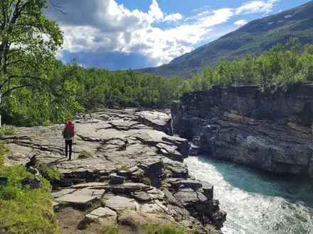
The Padjelantaleden is a roughly 140 km point-to-point hut trek through Padjelanta National Park in Swedish Lapland, usually walked in 9–10 days between Kvikkjokk and Ritsem. It is moderate: daily ascent is modest, the path is waymarked and huts are well spaced, but the route is remote, weather-exposed and dependent on boat transfers at both ends. It suits hikers who want open Arctic-alpine fell, Sami cultural landscapes and a quieter alternative to routes such as Abisko to Kebnekaise in Sweden.
Route Overview
Padjelantaleden is a linear trail that can be walked either way, though south-to-north from Kvikkjokk to Ritsem is common. From Kvikkjokk, a boat across the Tarraätno/Tarradalen river reaches the trailhead before the path passes STF huts at Njunjes, Tarrekaise and Såmmarlappa. It then enters the high plateau via BLT huts including Darreluoppal, Duottar, Stáloluokta, Árasluokta, Låddejåhkå and Gisuris. The northern end finishes near Áhkká/Akka and Änonjálmme, where a passenger boat crosses Lake Áhkájávrre/Akkajaure to Ritsem. For another Arctic thru-hike comparison, see Greenland’s Arctic Circle Trail.
Sami Routes, National Park and Laponia
Padjelantaleden follows ancient Sami migration and reindeer-grazing routes through Badjelánnda, the Lule Sami name meaning “the higher land”. Padjelanta National Park was established in 1962 to protect this high plateau, and the area became part of the Laponia UNESCO World Heritage Site in 1996 for both its natural values and living Sami culture. The huts inside the park are run by Badjelánnda Laponia Turism, a Sami-linked operator, while STF manages cabins at the southern and northern ends.
Notable highlights
- Padjelanta National Park: Sweden’s largest national park, a high Arctic-alpine plateau of open fell, lakes, rivers and reindeer-grazing land within the Laponia UNESCO World Heritage Site.
- Stáloluokta: The largest Sami summer settlement on the route, beside Lake Virihaure, with a small church/chapel and a helicopter link; hikers may sometimes buy local produce such as smoked Arctic char.
- Virihaure and Vastenjaure: Broad Lapland lakes near Stáloluokta, widely regarded as among Sweden’s most beautiful lake landscapes.
- Áhkká / Akka massif: The dominant mountain massif at the northern end, rising to about 2,015 m and nicknamed the “Queen of Lapland”.
- Hut chain: STF and BLT cabins create practical day stages across an otherwise remote route, with wild camping also allowed under allemansrätten.
Challenges to expect
Expect remoteness rather than technical difficulty. The first days include forest, boggy ground and boardwalks; the middle and northern sections are exposed Arctic-alpine fell with fast weather changes, stream crossings and limited shelter. Mosquitoes can be intense in July–August. There is no permit, but hut nights cost money and may be cash-only. Dogs are not permitted during the summer hiking season. For a less remote Swedish trail comparison, see Höga Kustenleden.
HikeList Score
Padjelantaleden scored 83/100 on HikeList's trail-quality metrics.
See score breakdownHide breakdown
- Ideal length 95
- Balanced challenge 100
- Scenery & wildness 71
- Varied terrain 94
- Accommodation 58
- Food & support 72
- Path quality 98
- Season flexibility 76
Computed from length, challenge, scenery & wildness, terrain variety, accommodation, food & support, path quality and season flexibility.
 Sweden
Show more data Show less
- Arctic Alpine
- Tundra
- Forest
- Bog
- Lakes
- Rivers
- Dirt
- Rocky
- Boardwalk
- Huts
- Wild Camping Spots
- Family Friendly
- Restrooms
- Water Sources
- Campsites
- Shelters
Photos from hikers
Taken on the trail by people who've reviewed Padjelantaleden.
Begin the journey from Kvikkjokk, following the trail northwest as it enters Padjelanta National Park. The route traverses through sparse forest and alongside rivers, climbing gently towards the plateau. The day finishes at the Njunjes hut, offering early glimpses of the mountainous terrain that characterizes much of the hike.
Leaving Njunjes, the trail climbs further, revealing views over the Tarradalen valley. The path passes through birch forests and along the rushing Tarra River, crossing occasional boardwalks over wetlands. Arrive at Tarrekaise and settle in for the night in the comfortable hut or set up camp nearby.
Today the trail continues along the valley, gradually ascending onto higher plateaus and open landscapes. Encounter a mix of birch forests, open tundra, and scenic streams. After a full day of hiking, reach the Såmmarlappa hut nestled in tranquil surroundings with views across the wild terrain.
Departing Såmmarlappa, follow the trail over undulating ground, skirting boggy sections and using boardwalks where needed. The route traverses remote moorland scattered with lakes before arriving at Tuottar hut, which offers shelter and a peaceful place to rest after a day of trekking through the wilds.
The path from Tuottar descends towards the large lakes that dominate this section of the trail. Cross open tundra and approach Staloluokta, a Sami settlement and a central highlight of Padjelantaleden. Here, interact with locals in summer and sample traditional Sami foods, enjoying a unique cultural experience.
Leaving Staloluokta, the path follows the western shore of Virihaure Lake—renowned for its clear waters and striking scenery. Skirt mountain slopes and cross small streams before reaching Arasluokta, another small Sami outpost surrounded by beautiful, open landscapes and wildflower meadows.
Continue along the Vaarekjåhkå river and pass multiple lakes, with expansive open vistas and distant views of the Akka massif. The route remains predominantly flat, with gentle rolling terrain. Arrive at Låddejåkkå hut, where the sound of rushing water accompanies your overnight stay.
Leave the river's edge and traverse alpine plateaus dotted with low vegetation and panoramic mountain views. The trail is mostly open and exposed, so be ready for wind and weather. Reach Kisuris hut, signaling the end of another remote and scenic day.
Today involves crossing suspension bridges and hiking along the base of the Akka mountains. The trail rolls across rocky and sometimes wet sections, providing spectacular views of the towering massif and nearby lakes. Arrive at the welcoming Akkastugorna huts at the base of Mount Akka.
The final section descends gradually towards Akkajaure Lake. Cross the lake via boat transfer (when in operation) or continue along marked paths to Ritsem. Complete your trek in Ritsem, where you’ll find rest facilities and the opportunity to reflect on your journey across Swedish Lapland’s pristine wilderness.
Reviews
How would you rate Padjelantaleden?
Tap a star to start your review — you could be the first.