Österreichischer Weitwanderweg 07 (Eastern Way)
How would you rate Österreichischer Weitwanderweg 07 (Eastern Way)?
Tap a star to share your experience and help other hikers.
Österreichischer Weitwanderweg 07: Eastern Austria Border Trail Guide
HikeList Score
Österreichischer Weitwanderweg 07 (Eastern Way) scored 81/100 on HikeList's trail-quality metrics.
See score breakdownHide breakdown
- Ideal length 52
- Balanced challenge 100
- Scenery & wildness 69
- Varied terrain 100
- Accommodation 92
- Food & support 88
- Path quality 70
- Season flexibility 100
Computed from length, challenge, scenery & wildness, terrain variety, accommodation, food & support, path quality and season flexibility.
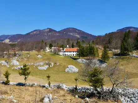
The Österreichischer Weitwanderweg 07, also called the Ostösterreichischer Grenzlandweg or “07er”, is a linear long-distance trail across eastern Austria. The main route is approximately 690–720 km and is usually walked in about 34 stages, or roughly four weeks. Technically it is the easiest of Austria’s official Weitwanderwege, rarely exceeding 1,000 m, but the overall effort is moderate because of the distance. It suits hikers who want villages, vineyards, river valleys, wetlands and borderland history rather than sustained alpine terrain.
Route Overview
The route starts at Nebelstein on the Austrian–Czech border in the northern Waldviertel and finishes at Bad Radkersburg in the Styrian Vulkanland on the Slovenian border. It crosses Lower Austria, Vienna, Burgenland and Styria, making it the only Austrian Weitwanderweg to pass directly through Vienna. The four named sections are the Thayatalweg, Weinviertler Grenzlandweg, Via Pannonia and Oststeirischer Grenzlandweg, with key places including Weitra, Gmünd, Hardegg, Retz, the Donauinsel, Hainburg, Lake Neusiedl, Hartberg and Fürstenfeld. This is a point-to-point walk, so plan separate start and finish logistics. For comparison, see the river-focused Donausteig (Danube Trail) or more alpine Austrian routes such as the Carnic High Trail and Eagle Walk.
Borderland history of the 07er
The Österreichischer Weitwanderweg 07 was inaugurated on 22–23 September 1979 as one of Austria’s classic long-distance routes. Its line follows Austria’s eastern frontier and, for much of the way, traces the former Iron Curtain border with Czechoslovakia, Hungary and Yugoslavia. Much of this once-restricted border landscape is now valuable protected nature. Sections of the route also coincide with the European long-distance paths E8 and E4.
Notable highlights
- Hardegg & Thayatal National Park: Hardegg is Austria’s smallest town, set on the River Thaya below a large medieval castle. The surrounding Thayatal National Park protects a deeply incised, forested river canyon shared with the Czech Podyjí park.
- Vienna via the Danube Island: The 07 is the only Austrian Weitwanderweg to pass straight through Vienna. Crossing the Donauinsel gives a rare urban break in a long rural thru-hike.
- Lake Neusiedl and Illmitz: Neusiedler See is a vast, shallow steppe lake on the Austria–Hungary border. Around Illmitz, the route reaches some of Austria’s lowest terrain, with reedbeds and Seewinkel wetlands known for birdlife.
- Weinviertel & Retz wine country: The trail crosses the Weinviertel, Austria’s largest wine region. Retz is a historic walled town noted for its extensive underground wine cellars.
- Hochwechsel: At about 1,743 m, Hochwechsel is the trail’s highest point and the main upland section. Expect open alpine pasture and broad views over eastern Austria.
Challenges to expect
Do not underestimate the 07er because it is technically easy. The challenge is cumulative distance: around 690–720 km with about 9,000 m of ascent. Much of the route uses asphalt, roads, dirt roads and forest tracks, so footwear comfort matters. Eastern Austria can be very hot in midsummer, especially in the Weinviertel and Burgenland. Waymarking is red-white-red with the number 07, but long lowland stages still require attention.
HikeList Score
Österreichischer Weitwanderweg 07 (Eastern Way) scored 81/100 on HikeList's trail-quality metrics.
See score breakdownHide breakdown
- Ideal length 52
- Balanced challenge 100
- Scenery & wildness 69
- Varied terrain 100
- Accommodation 92
- Food & support 88
- Path quality 70
- Season flexibility 100
Computed from length, challenge, scenery & wildness, terrain variety, accommodation, food & support, path quality and season flexibility.
 Austria
Show more data Show less
- Lowland
- Forest
- Vineyards
- River Valleys
- Wetland
- Farmland
- Upland
- Asphalt
- Dirt Road
- Forest Track
- Road
- Footpath
- Guesthouses
- Pensions
- Hotels
- Wine Taverns
- Family Friendly
- Pet Friendly
- Restrooms
- Water Sources
- Campsites
- Shelters
- Picnic Areas
Photos from hikers
Taken on the trail by people who've reviewed Österreichischer Weitwanderweg 07 (Eastern Way).
Reviews
How would you rate Österreichischer Weitwanderweg 07 (Eastern Way)?
Tap a star to start your review — you could be the first.