Oostvaardersplassen Trail
How would you rate Oostvaardersplassen Trail?
Tap a star to share your experience and help other hikers.
Oostvaardersplassen Trail: Flat Wetland Walking in Flevoland
HikeList Score
Oostvaardersplassen Trail scored 71/100 on HikeList's trail-quality metrics.
See score breakdownHide breakdown
- Ideal length 55
- Balanced challenge 50
- Scenery & wildness 68
- Varied terrain 94
- Accommodation 83
- Food & support 75
- Path quality 98
- Season flexibility 76
Computed from length, challenge, scenery & wildness, terrain variety, accommodation, food & support, path quality and season flexibility.
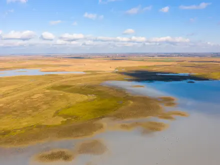
The Oostvaardersplassen Trail is an easy, flat walking loop through the Oostvaardersplassen, a rewilded wetland reserve in Zuidelijk Flevoland, the Netherlands. The full marked circuit from Buitencentrum Oostvaardersplassen is officially 11.3 km, often rounded to 12 km, and takes roughly 3 hours. It suits walkers wanting a half- to full-day route with bird hides, open polder horizons and a good chance of seeing grazing herds. There is no climbing, rough ground or hut logistics: this is a straightforward day walk.
Route Overview
Start and finish at Buitencentrum Oostvaardersplassen, Kitsweg 1, Lelystad. The route is a marked loop network rather than one canonical long-distance trail: the full circuit combines the Oostvaardersplassen core route and Oostvaardersveld section, with shorter signed options of 5.1 km and 7.3 km. Key points include the visitor centre, bird hides such as De Zeearend, De Krakeend, De Poelruiter, De Brandgans and Wigbels Eiland, plus the Praambult / Grote Praambult viewpoint roughly halfway round. Access is by car; there is no direct public transport to the Buitencentrum. For more lowland walking in the Netherlands, compare the wetland-focused Biesbosch National Park Trail or the urban-river Amstel River Trail.
How Oostvaardersplassen Became a New Wilderness
Oostvaardersplassen sits on land reclaimed from the IJsselmeer in 1968 as part of Zuidelijk Flevoland. It was earmarked for industry, but the boggy ground was colonised by greylag geese and marshland instead, later becoming a Ramsar wetland. From the late 1970s, biologist Frans Vera led a rewilding scheme with konik ponies, Heck cattle and red deer. After harsh winter losses in 2017–18, Flevoland changed herbivore management. The reserve became part of Nieuw Land National Park in 2018.
Notable highlights
- Rewilded grazing herds: Konik ponies, red deer and Heck cattle graze the reserve year-round. They are the signature sight of the Oostvaardersplassen and central to its Dutch rewilding story.
- White-tailed eagles: This large bird of prey began breeding here around the late 2000s, marking the first nesting in the Netherlands in centuries. The reserve is one of the country’s key places to look for them.
- Bird hides and the Praambult viewpoint: Hides including De Zeearend, De Krakeend, De Poelruiter, De Brandgans and Wigbels Eiland give sheltered viewing over ponds, reedbeds and open water. The Praambult mound adds a wide panorama across the reserve.
- Buitencentrum Oostvaardersplassen: The outdoor centre is the gateway for the marked walks, with a café, terrace overlooking ponds, shop and information desk. All signed walking routes start here.
- Oostvaardersveld: This section stays open year-round and adds open grassland, willow scrub and wetland margins to the walk.
Challenges to expect
The walking is easy, but the landscape is exposed: wind, rain and sun can feel stronger on the open polder. Navigation is simple if you follow the marked loops, but check closures before travelling: the 5.1 km Oostvaardersplassen core route is closed January to April, while Oostvaardersveld remains open. There is no direct public transport to the visitor centre, and dogs are only allowed on a lead on some sections. For a longer marked Dutch walk, see the Floris V Trail.
HikeList Score
Oostvaardersplassen Trail scored 71/100 on HikeList's trail-quality metrics.
See score breakdownHide breakdown
- Ideal length 55
- Balanced challenge 50
- Scenery & wildness 68
- Varied terrain 94
- Accommodation 83
- Food & support 75
- Path quality 98
- Season flexibility 76
Computed from length, challenge, scenery & wildness, terrain variety, accommodation, food & support, path quality and season flexibility.
 Netherlands
Show more data Show less
- Wetland
- Grassland
- Reed Marsh
- Polder
- Gravel
- Compacted Earth
- Grass
- Hotels
- B&Bs
- Campsites
- Family Friendly
- Pet Friendly
- Restrooms
- Picnic Areas
- Campsites
Photos from hikers
Taken on the trail by people who've reviewed Oostvaardersplassen Trail.
Reviews
How would you rate Oostvaardersplassen Trail?
Tap a star to start your review — you could be the first.