Amstel River Trail
How would you rate Amstel River Trail?
Tap a star to share your experience and help other hikers.
Amstel River Trail: Amsterdam’s easy riverside day walk
HikeList Score
Amstel River Trail scored 66/100 on HikeList's trail-quality metrics.
See score breakdownHide breakdown
- Ideal length 55
- Balanced challenge 50
- Scenery & wildness 68
- Varied terrain 100
- Accommodation 57
- Food & support 81
- Path quality 65
- Season flexibility 89
Computed from length, challenge, scenery & wildness, terrain variety, accommodation, food & support, path quality and season flexibility.
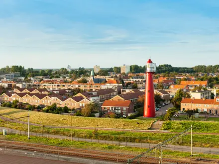
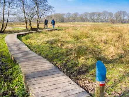
The Amstel River Trail is a flat 14 km day walk in the Netherlands, following the River Amstel south from central Amsterdam to Ouderkerk aan de Amstel. It is not a single official branded trail, but a well-used riverside route on paved towpaths, quiet lanes and park paths. With negligible ascent, easy navigation and cafés at the village end, it suits first-time visitors, casual hikers and anyone wanting a low-effort walk from Amsterdam into the Amstelland polders.
Route Overview
Start in central Amsterdam, commonly at the Magere Brug or near the H'ART museum by Waterlooplein, then follow the Amstel past the Amstelsluizen and south through Martin Luther King Park, Amstelpark, De Riekermolen, Zorgvlied cemetery and Wester-Amstel estate. The route finishes in Ouderkerk aan de Amstel, a historic riverside village with places to eat and drink. The 14 km version is best treated as a point-to-point walk, with an easy return by bus. Published versions vary: some make it a longer there-and-back from Amsterdam. For more Dutch lowland walking, compare the Groene Hart Pad or the Floris V Trail.
The river that named Amsterdam
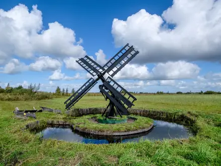
The Amstel gave Amsterdam its name: “Amstel Dam” refers to the 13th-century dam built across the river’s mouth. Ouderkerk aan de Amstel, now the walk’s village finish, was once the seat of the medieval Van Amstel lords before Amsterdam grew to dominate the area. In the Dutch Golden Age, the riverbanks south of the city filled with polder-drainage windmills and country estates such as Wester-Amstel, while Rembrandt sketched the Amstel landscape near De Riekermolen.
Notable highlights
- Magere Brug / Skinny Bridge: An iconic white double-leaf drawbridge over the Amstel in central Amsterdam and a classic place to begin the walk.
- Amstelsluizen: Historic sluices first built in 1673, still associated with regulating Amsterdam’s canal water levels as the city gives way to open riverside.
- Amstelpark: A leafy west-bank park created for a 1972 garden festival, useful for a green pause before the route enters more open polder scenery.
- De Riekermolen windmill: A 1636 polder-drainage smock mill beside the Amstel, linked with Rembrandt sketches and still turning at summer weekends.
- Wester-Amstel estate: A Dutch Golden Age country house from 1662, with gardens open to walkers and a reminder of the merchants’ rural retreats along the river.
- Ouderkerk aan de Amstel and Beth Haim cemetery: The historic village marks the route’s end; nearby Beth Haim is the Netherlands’ oldest Jewish cemetery, established by Amsterdam’s Sephardic community in 1614.
Challenges to expect
The walking is easy, but expect urban edges, cyclists, shared paths and exposed flat sections where wind or rain can matter more than terrain. Most of the route is paved, with a few unpaved park or riverbank stretches. Navigation is simple if you keep to the Amstel, though signage is only partial. If you want a wilder wetland contrast, see the Biesbosch National Park Trail; for coastal walking, see the Dutch Coastal Path.
HikeList Score
Amstel River Trail scored 66/100 on HikeList's trail-quality metrics.
See score breakdownHide breakdown
- Ideal length 55
- Balanced challenge 50
- Scenery & wildness 68
- Varied terrain 100
- Accommodation 57
- Food & support 81
- Path quality 65
- Season flexibility 89
Computed from length, challenge, scenery & wildness, terrain variety, accommodation, food & support, path quality and season flexibility.
Show more data Show less
- River
- Polder
- Pasture
- Parks
- Paved
- Asphalt
- Park Paths
- Unpaved
- Hotels
- Wheelchair Accessible
- Stroller Accessible
- Family Friendly
- Pet Friendly
- Restrooms
- Water Sources
- Picnic Areas
In these collections
Photos from hikers
Taken on the trail by people who've reviewed Amstel River Trail.
Reviews
How would you rate Amstel River Trail?
Tap a star to start your review — you could be the first.