Lauterbrunnen Valley Trail
How would you rate Lauterbrunnen Valley Trail?
Tap a star to share your experience and help other hikers.
Lauterbrunnen Valley Trail: Easy Waterfall Walk
HikeList Score
Lauterbrunnen Valley Trail scored 79/100 on HikeList's trail-quality metrics.
See score breakdownHide breakdown
- Ideal length 51
- Balanced challenge 64
- Scenery & wildness 88
- Varied terrain 94
- Accommodation 100
- Food & support 88
- Path quality 80
- Season flexibility 89
Computed from length, challenge, scenery & wildness, terrain variety, accommodation, food & support, path quality and season flexibility.
The Lauterbrunnen Valley Trail is an easy, mostly flat valley-floor walk in the Bernese Oberland, Switzerland. It runs around 7 km from Lauterbrunnen village to Stechelberg beside the Weisse Lütschine, usually taking about 2 hours. This is a genuine half-day day walk, not a multi-day trek, and suits families, beginners and most fitness levels. Expect meadows, alpine farmland, sheer limestone cliffs and famous waterfalls, with a frequent postbus back to Lauterbrunnen.
Route Overview
Walk point to point from Lauterbrunnen village, starting near the train station or church at about 800 m, towards Stechelberg at the head of the valley. The route first passes Staubbach Falls, then follows lanes and well-maintained dirt or crushed-gravel paths along the Weisse Lütschine. A signed detour leads to Trümmelbach Falls, while Buchen and the cliffs below Mürren mark the middle of the valley. The finish is at Stechelberg, by the postbus stop and Schilthornbahn cable-car station. For longer Swiss mountain objectives, compare the Alpine Pass Route or the Aletsch Glacier Panorama Trail.
Lauterbrunnen’s Literary and Alpine History
Lauterbrunnen was first recorded in 1240 as “in claro fonte”, meaning “clear spring”, and the church stands at 802 m. The valley’s waterfalls drew Romantic-era visitors: Goethe stayed near Staubbach Falls in 1779 and wrote “Gesang der Geister über den Wassern” (“Song of the Spirits over the Waters”), and Lord Byron also visited. J.R.R. Tolkien hiked from Interlaken into the valley in 1911; the landscape later became the pictorial model for his sketches of Rivendell.
Notable highlights
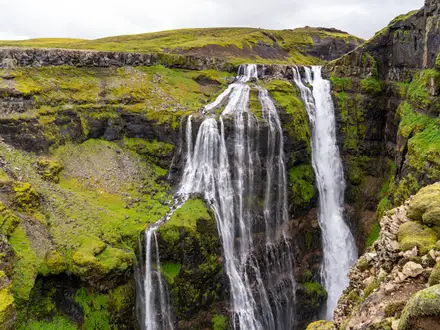
- Staubbach Falls (297 m): Switzerland’s highest free-falling waterfall drops from the cliff just beyond Lauterbrunnen. A short path leads up behind the misty veil of water.
- Trümmelbach Falls (signed detour): Ten glacier-fed waterfalls are carved inside the mountain and reached by tunnel funicular and galleries. They drain meltwater from the Eiger, Mönch and Jungfrau.
- Walled glacial valley: The classic U-shaped trough is hemmed in by near-vertical limestone cliffs up to about 1000 m high. Roughly 72 waterfalls tumble over the rim, giving the valley its name.
- Mürren and the cliffs: High on the western wall, car-free Mürren sits on the lip of the valley. Nearby Mürrenbach Falls, at 417 m, is the tallest waterfall in Switzerland.
- Stechelberg and the Jungfrau wall: The walk ends beneath the cliffs at the foot of the Jungfrau massif. The Schilthorn cable car leaves from the valley floor here.
Challenges to expect
This is an easy walk, but Alpine weather can change fast, even on the low valley floor. The route is mostly flat, with around 150 m of ascent, and mixes paved lanes with dirt and crushed-gravel riverside path. Navigation is straightforward, though the walk is point to point, so plan the postbus return from Stechelberg. Trümmelbach Falls is optional and has an entry fee.
HikeList Score
Lauterbrunnen Valley Trail scored 79/100 on HikeList's trail-quality metrics.
See score breakdownHide breakdown
- Ideal length 51
- Balanced challenge 64
- Scenery & wildness 88
- Varied terrain 94
- Accommodation 100
- Food & support 88
- Path quality 80
- Season flexibility 89
Computed from length, challenge, scenery & wildness, terrain variety, accommodation, food & support, path quality and season flexibility.
 Switzerland
Show more data Show less
- Valley
- River
- Meadows
- Alpine Farmland
- Paved
- Dirt
- Gravel
- Hotels
- Guesthouses
- Hostels
- Campsites
- Family Friendly
- Pet Friendly
- Stroller Accessible
- Restrooms
- Water Sources
- Campsites
- Picnic Areas
Photos from hikers
Taken on the trail by people who've reviewed Lauterbrunnen Valley Trail.
Start in Lauterbrunnen village near the train station or church, pass Staubbach Falls, follow the Weisse Lütschine through meadows and hamlets, take the signed detour to Trümmelbach Falls if wanted, then continue below Mürren to Stechelberg for the postbus back.
Reviews
How would you rate Lauterbrunnen Valley Trail?
Tap a star to start your review — you could be the first.