Lancashire Witches Walk
How would you rate Lancashire Witches Walk?
Tap a star to share your experience and help other hikers.
Lancashire Witches Walk: Pendle to Lancaster on Foot
HikeList Score
Lancashire Witches Walk scored 86/100 on HikeList's trail-quality metrics.
See score breakdownHide breakdown
- Ideal length 81
- Balanced challenge 84
- Scenery & wildness 82
- Varied terrain 94
- Accommodation 100
- Food & support 81
- Path quality 80
- Season flexibility 89
Computed from length, challenge, scenery & wildness, terrain variety, accommodation, food & support, path quality and season flexibility.
The Lancashire Witches Walk is an 82 km waymarked point-to-point trail in Lancashire, England, from Barrowford to Lancaster. Allow 4-5 days. It is a hard, non-technical walk: farmland and valley paths are balanced by remote, exposed Bowland moorland where navigation can matter. It suits experienced long-distance walkers who want a compact but serious route with strong local history, varied terrain and a clear finish at Lancaster Castle.
Route Overview
The route starts at Pendle Heritage Centre, Barrowford, and runs south-east to north-west across Lancashire to Lancaster Castle. It dips past Read Park, turns north to Clitheroe, then crosses the Ribble Valley into the Forest of Bowland via Slaidburn. The crux is the Salter Fell / Hornby Road crossing, the highest and most remote section, before the trail drops to the Lune Valley at Caton and follows the river via Crook o' Lune to Lancaster. Barrowford, Clitheroe and Lancaster have public transport links, but the Bowland middle is remote. For other UK upland routes, compare the Beacons Way or Annandale Way.
The Pendle Witch Trials of 1612
The walk commemorates the 1612 Pendle witch trials, among the best-known witch trials in English history. Accused people from the Pendle area were taken to Lancaster Assizes after investigations led by magistrate Roger Nowell. Nine were convicted and hanged at Gallows Hill in Lancaster on 20 August 1612; one more, Jennet Preston, was hanged at York. The route’s ten cast-iron tercet markers stand for the ten people executed.
Notable highlights
Pendle Heritage Centre, Barrowford: The official start, set among historic buildings linked to the Pendle witches and local life. It is the natural place to orient yourself before leaving Barrowford.
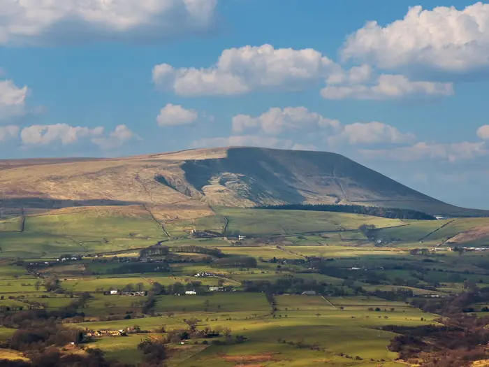
Pendle Hill and the Forest of Pendle: Pendle Hill is the 557 m landmark that dominates the opening miles, but the walk passes beneath it rather than over the summit. The early stages give the historical setting without committing you to the hilltop.
Clitheroe: A Ribble Valley market town with a small Norman keep on a limestone knoll. It is roughly a third of the way along and is the last strong resupply and accommodation stop before the wilder Bowland section.
Slaidburn and the Forest of Bowland: Slaidburn is a stone village with an old inn and YHA hostel, about halfway along the walk. Beyond it, the Forest of Bowland National Landscape becomes more remote, open and upland.
Salter Fell / Hornby Road: An ancient packhorse salt road over the Bowland fells and the walk’s highest, wildest section. Expect exposed moorland, rough going and more serious navigation than on the valley stages.
Lancaster Castle and Gallows Hill: The finish stands at the medieval castle where the accused were imprisoned and tried, overlooking Gallows Hill where they were hanged in 1612. Castle tours are separate from the walk.
Challenges to expect
The main difficulty is the Bowland crossing: remote, exposed, wet and sometimes boggy moorland around Salter Fell / Hornby Road. Waymarking exists, but it is sparser on the high ground, so carry a map, compass/GPS and know how to use them. The walk has roughly 1,850 m of ascent, limited facilities in the middle section, and winter brings short daylight, mist and harsher navigation.
HikeList Score
Lancashire Witches Walk scored 86/100 on HikeList's trail-quality metrics.
See score breakdownHide breakdown
- Ideal length 81
- Balanced challenge 84
- Scenery & wildness 82
- Varied terrain 94
- Accommodation 100
- Food & support 81
- Path quality 80
- Season flexibility 89
Computed from length, challenge, scenery & wildness, terrain variety, accommodation, food & support, path quality and season flexibility.
 United Kingdom
 England
Show more data Show less
- Moorland
- Rolling Hills
- River Valley
- Forest
- Farmland
- Dirt
- Gravel
- Paved
- Hostels
- Inns
- Guesthouses
- Hotels
- Bnbs
- Family Friendly
- Pet Friendly
- Restrooms
- Water Sources
- Campsites
Download Our Full Guide to Lancashire Witches Walk FREE!
Get our comprehensive guide to this hike for free. Save it for later reading or print out at home.
Photos from hikers
Taken on the trail by people who've reviewed Lancashire Witches Walk.
Lancashire Witches Walk: The Complete Guide
 i
Image by Jane McIlroy
i
Image by Jane McIlroy The Lancashire Witches Walk is a compact but serious 82 km crossing of Lancashire, linking Pendle Heritage Centre in Barrowford with the hard historical finish at Lancaster Castle. It suits experienced long-distance walkers who want varied walking, strong local history and a route that can be completed in a long weekend or a steady five days.
The opening stages keep Pendle Hill in view without climbing its summit, moving through Barrowford, Barley, Higham, Read Old Bridge, Whalley and Clitheroe on field paths, parkland, lanes and Ribble Valley tracks. Along the way, yellow-and-blue witch’s-face discs and cast-iron tercet waymarkers tie the landscape to the 1612 Pendle witch trials.
The character changes beyond Clitheroe and Slaidburn, where the Forest of Bowland becomes the defining challenge. The Salter Fell / Hornby Road crossing is remote, exposed, wet underfoot in poor conditions and reaches the route’s high point at roughly 416–417 m.
After the moors, the walk drops towards Roeburndale, Caton and the Lune Valley, with the Crook o’ Lune and Williamson Park marking the approach to Lancaster. The finish at Lancaster Castle gives the route a clear destination rather than just an arbitrary end point.
This is not a technical trail, but it asks for proper hill kit, careful accommodation planning around Slaidburn, and confident navigation on the Bowland stage. Valley days are gentler, yet mud, sparse services and changeable upland weather can still affect the schedule.
This guide covers stages, days, accommodation, food, transport, terrain and the common mistakes to avoid.
Stage-by-Stage Guide
Stage 1: Barrowford to Higham via Barley — approx. 16 km
The walk begins at Pendle Heritage Centre in Barrowford, beneath Pendle Hill. This opening stage is the easiest way into the route: rural, low-level and historically rich, with Pendle Hill dominating the skyline but not climbed by the trail.
Expect a mix of field paths, quiet lanes and village approaches through the Forest of Pendle area. Underfoot conditions are generally straightforward, but field sections can be muddy and waterlogged after rain, especially where livestock has churned gateways and stiles.
Barley is the main place passed between Barrowford and Higham, and it is the natural point to pause beneath Pendle Hill. The first of the route’s cast-iron tercet waymarkers are also part of this early Pendle section, linking the landscape to Carol Ann Duffy’s poem and the 1612 trials.
Food and water are easiest to sort before leaving Barrowford. Barley and Higham are small villages, so do not rely on late opening hours or full resupply without checking locally before setting off.
Accommodation at the end of this stage needs planning. Higham is used as a stage point, but the accommodation base for the route is stronger in Barrowford, Clitheroe, Slaidburn, Caton and Lancaster; availability in or around Higham should be checked before travelling.
Public transport access is strongest at the start of the walk, with Barrowford reached via nearby Nelson and Colne railway stations and onward bus links. Road access to the Pendle villages is practical, but any bus connection for Higham should be checked before relying on it.
Navigation is usually moderate on this stage because the route is waymarked with yellow-and-blue witch-face discs, but the waymarking should not replace a map or GPS track. Pay particular attention at field boundaries, lane crossings and around village edges, where long-distance trail signs can be easier to miss.
Stage 2: Higham to Clitheroe via Read Old Bridge — approx. 16 km
This stage continues across the gentler Pendle and Ribble Valley side of the walk. It is still a lowland day compared with Bowland, with farmland, riverside influence and settled villages rather than open fell.
The route heads by Read / Read Old Bridge, then towards Whalley and Spring Wood before reaching Clitheroe. Terrain is a practical mix of field paths, parkland-style walking, lanes and village approaches, with mud likely after wet weather.
Views broaden across the Ribble Valley, with Pendle Hill still a major landmark behind and to the side of the route. Clitheroe gives the stage a strong finish, with its small Norman keep on a limestone knoll and one of the tercet waymarkers associated with the route.
Clitheroe is the key resupply point on the first half of the walk and should be treated as the last strong service stop before the more remote Bowland stages. Carry enough food for the following day if continuing beyond Clitheroe, and plan water carefully before the Slaidburn stage.
Accommodation is much easier in Clitheroe than at some of the smaller stage points. Inns, guesthouses, B&Bs and hotels are part of the route’s normal accommodation pattern here, but booking ahead is still sensible on weekends and in the main walking season.
Clitheroe has a railway station on the Ribble Valley line to Blackburn and Manchester, making it the most practical mid-route public transport access point before the Bowland crossing. Higham’s public transport options should be checked before travelling if starting or finishing this stage there.
Navigation remains mostly straightforward in settled country, but field-path walking still demands attention. Keep an eye on waymarks at farms, wooded sections near Whalley / Spring Wood, and where the route threads between paths and lanes.
Stage 3: Clitheroe to Slaidburn — approx. 16 km
This is the transition stage from the Ribble Valley into the Forest of Bowland National Landscape. It begins from a well-serviced market town and ends in a small stone village that becomes the key base before the wildest part of the whole walk.
The walking is more committing than the first two days, though it is still not the high moor crossing itself. Expect field paths, quiet lanes, gravel tracks and gradually rougher rural terrain as the route leaves Clitheroe behind and works towards Slaidburn.
The main planning feature of this stage is Slaidburn. It sits almost halfway along the route and is the important overnight point before Salter Fell / Hornby Road, with an old inn and a YHA hostel noted as well placed for walkers.
Clitheroe is the place to leave with supplies. Once on the way to Slaidburn, services become more limited, so carry lunch, snacks and enough water for the day rather than assuming there will be options en route.
Accommodation in Slaidburn should be booked ahead, because it is the practical overnight base for the Bowland crossing and alternatives are limited in the immediate area. This is not a stage to leave accommodation vague and hope to sort it out on arrival.
Clitheroe has good rail access for starting, ending or joining the route. Slaidburn is in the remote Bowland middle of the walk, where rural bus services are sparse; onward or escape transport should be checked before travelling.
Navigation becomes more important as the route moves away from the Ribble Valley’s larger settlements. The waymarking continues, but a map, compass or GPS track should already be in use before the more exposed ground on the next stage.
Stage 4: Slaidburn to the Lune Valley / Caton area via Salter Fell and Hornby Road — approx. 16 km
This is the hardest and most serious stage of the Lancashire Witches Walk. It crosses the Forest of Bowland fells on Salter Fell / Hornby Road, an old packhorse salt road and part-Roman route, reaching the walk’s high point on the Whitendale / Croasdale watershed at roughly 416–417 m.
The terrain changes decisively here. Expect open, exposed moorland, rough fell track and wet or boggy sections, with fewer facilities and less shelter than on any other part of the route.
In good weather this is the wild centrepiece of the walk, with big Bowland views and a real sense of leaving the settled valleys behind. In poor visibility, strong wind or heavy rain, it becomes a navigational and exposure problem rather than just a longer rural walk.
Leave Slaidburn with all food and water needed for the day. There should be no assumption of reliable resupply on the moorland crossing, and weather can make the stage slower than its distance suggests.
The stage finishes by dropping towards Roeburndale / Littledale and the Lune Valley, with Caton the practical accommodation area identified for this part of the route. Inns, guesthouses, B&Bs and hotels are part of the wider route accommodation pattern around Caton, but availability should be checked before travelling.
Public transport is limited through the Bowland middle. Slaidburn, Salter Fell and the moorland section are not places to rely on easy escape by bus, so road support, lifts or taxi arrangements should be planned in advance if needed.
Navigation is the main warning on this stage. The route is waymarked, but on the high moorland the marking is sparser and can be hard to follow in mist, rain or low cloud; a map, compass or GPS is essential.
Start early enough to avoid finishing in fading light, especially outside high summer. The stage is non-technical, but wet ground, exposure, wind chill and poor visibility make proper hill kit necessary.
Stage 5: Caton / Lune Valley to Lancaster Castle via Crook o’ Lune — approx. 16 km
The final stage is a clear contrast with the Bowland crossing: easier, lower and more settled, following the Lune Valley towards Lancaster. It is still a full walking day, but the serious upland exposure is behind you.
The route uses riverside paths, quieter tracks and urban-edge approaches as it works through the Lune Valley. Underfoot conditions are generally simpler than on Salter Fell, though riverside and field sections can still be muddy after rain.
Crook o’ Lune is the major landscape highlight of the day: the horseshoe bend of the River Lune near Caton, long celebrated as a viewpoint and associated with Turner. One of the cast-iron tercet waymarkers is placed here, making it both a scenic and commemorative point on the route.
The approach to Lancaster passes via Halton and Williamson Park before finishing at Lancaster Castle. The castle is the historical endpoint of the walk: the place where the accused were imprisoned and tried at the Lancaster Assizes in 1612.
Food and water are easier to manage than on the Bowland day because the stage moves through the Lune Valley and into Lancaster. Even so, carry enough for the day from Caton, as small-village services and opening hours can vary.
Accommodation is strongest at the finish. Lancaster has hotels and other town accommodation, while Caton is also listed among the route’s accommodation bases; booking ahead remains sensible during busy periods.
Transport at the end is excellent compared with the route’s middle section. Lancaster is a major station on the West Coast Main Line, making onward travel straightforward, while any local buses from Caton or Halton should be checked before travelling.
Navigation is easier than on the moors, but do not switch off. The main points to watch are path junctions along the Lune Valley, transitions around Halton and the urban approach through Williamson Park to Lancaster Castle.
Recommended Itinerary
Standard 5-day itinerary
The most practical schedule is the five-day version used by the published staging: roughly 16 km per day, with the remote Forest of Bowland crossing kept as its own stage from Slaidburn to the Lune Valley. This is the best choice for most walkers because it avoids turning the Salter Fell / Hornby Road day into an overlong outing and keeps the easier valley sections manageable.
| Day | From | To | Approx. distance | Why this stage makes sense | Services/accommodation notes |
|---|---|---|---|---|---|
| 1 | Barrowford, from Pendle Heritage Centre | Higham, via Barley | 16 km | A measured opening day beneath Pendle Hill, with time to settle into waymarking and field-path navigation without tackling the Bowland fells too early. | Barrowford has accommodation and is the official start. Higham is a smaller overnight stop, so accommodation should be booked before committing to this stage. |
| 2 | Higham | Clitheroe, via Read Old Bridge | 16 km | Keeps the walk moving through the easier Pendle and Ribble Valley terrain and finishes in the route’s strongest mid-walk service town. | Clitheroe is a key resupply and accommodation stop, with a railway station on the Ribble Valley line. It is the last substantial town before the wilder Bowland section. |
| 3 | Clitheroe | Slaidburn | 16 km | Positions you correctly for the high, exposed Salter Fell / Hornby Road crossing on the following day, rather than approaching it tired from a longer stage. | Slaidburn is a critical overnight point, with a well-placed YHA hostel and an inn. Book ahead, as alternatives in the Forest of Bowland middle section are limited. |
| 4 | Slaidburn | Caton / Lune Valley, via Salter Fell / Hornby Road | 16 km | This is the key hill day: remote, exposed, potentially wet and boggy, and the route’s highest section at about 416–417 m. Keeping it as a single stage gives more margin for weather and navigation. | Facilities are sparse across the moorland. Carry food, water, waterproofs, warm layers, and map/compass or GPS. Caton and the Lune Valley are the practical onward overnight area. |
| 5 | Caton / Lune Valley | Lancaster Castle, via Crook o’ Lune and Williamson Park | 16 km | A lower, more straightforward final day along the Lune Valley into Lancaster, finishing at the castle where the accused were tried. | Lancaster has the best finish logistics, with a major station on the West Coast Main Line and a wide range of accommodation. |
Slower option
A slower approach is best treated as a five-day walk with extra overnight time, rather than trying to force unverified short stages into the Bowland middle. The most useful places to add flexibility are Clitheroe and Slaidburn: Clitheroe for resupply and transport, Slaidburn for weather planning before the exposed moorland crossing.
This suits walkers who want shorter-feeling days, more time for the historical waymarkers, or a better weather window for Salter Fell / Hornby Road. Any attempt to split the route into six shorter walking days depends on accommodation and transport in smaller villages, so this should be checked before travelling.
Faster option
Fit long-distance walkers can complete the route in four days by combining the first two standard stages:
| Day | From | To | Approx. distance | Why this stage makes sense | Services/accommodation notes |
|---|---|---|---|---|---|
| 1 | Barrowford | Clitheroe, via Barley, Higham and Read Old Bridge | 32 km | Combines the easier opening farmland and valley stages, leaving the Bowland crossing to be tackled later as a separate day. | Start early and ensure the route into Clitheroe is within daylight. Clitheroe is the logical first overnight stop because it has strong services and rail access. |
| 2 | Clitheroe | Slaidburn | 16 km | A shorter second day before the remote upland section, useful after the long opening day. | Book Slaidburn accommodation ahead; options are limited compared with Clitheroe and Lancaster. |
| 3 | Slaidburn | Caton / Lune Valley, via Salter Fell / Hornby Road | 16 km | Keeps the hardest and most exposed section as a self-contained stage, which is the safest way to handle the Bowland fells. | Carry hill kit and navigation. Do not rely on finding services between Slaidburn and the Lune Valley. |
| 4 | Caton / Lune Valley | Lancaster Castle | 16 km | A manageable final stage into Lancaster, with good onward transport at the finish. | Lancaster is the simplest place to finish, overnight or travel home. |
A three-day crossing is possible only for very fit walkers with carefully arranged accommodation, long daylight and confidence on remote ground. Exact day splits should be planned from official mapping before booking, especially around Slaidburn, Salter Fell and the Lune Valley.
Planning the Route
How many days to allow
Most walkers should plan the Lancashire Witches Walk over five days, using the natural rhythm of the route: Pendle and Ribble Valley paths first, the remote Bowland crossing in the middle, then the easier Lune Valley approach to Lancaster. The accompanying guidebook divides the walk into short sections that work well as five manageable day walks.
A four-day itinerary suits fit long-distance walkers who are comfortable with longer days and can book accommodation in the right places. A three-day crossing is possible for strong walkers, but it leaves little margin for slow ground, wet moorland, navigation stops or transport delays.
The key planning point is not the total distance; it is the Slaidburn to Lune Valley day over Salter Fell / Hornby Road. That stage is exposed, high, wet underfoot in poor conditions and much more serious than the valley walking either side.
Natural stage pattern
The route is easiest to plan around its existing five-stage structure. Each day is roughly similar in distance, but not in seriousness: the Bowland day needs the most daylight, food, water and navigation confidence.
| Stage | Typical section | Planning notes |
|---|---|---|
| 1 | Barrowford to Higham via Barley | A gentler opening beneath Pendle Hill. Overnight options in smaller villages should be booked carefully and checked before travelling. |
| 2 | Higham to Clitheroe via Read Old Bridge | Easier Ribble Valley walking, finishing at the strongest resupply and transport point before Bowland. |
| 3 | Clitheroe to Slaidburn | A transition day into the Forest of Bowland. Slaidburn is the key overnight stop before the remote moorland crossing. |
| 4 | Slaidburn to the Lune Valley / Caton area via Salter Fell and Hornby Road | The committing day of the route: remote, exposed fell and moorland with sparse facilities. Start early and carry proper hill kit. |
| 5 | Caton / Lune Valley to Lancaster Castle via Crook o' Lune | Easier riverside and valley walking into Lancaster, with the historic finish at the castle. |
Booking accommodation
Accommodation planning matters most around Slaidburn and the Lune Valley / Caton area. Slaidburn is almost exactly where it is needed for the Bowland crossing, with a YHA hostel and an inn, but choice is limited and should be booked ahead.
Barrowford, Clitheroe, Caton and Lancaster offer more practical bases than the smaller villages. The five-day version may require careful booking or local transfer arrangements around Higham, depending on availability. This should be checked before travelling.
For a four-day itinerary, avoid creating an overlong Bowland day by accident. The safest approach is to keep Slaidburn as an overnight stop and adjust the easier valley stages either side.
Food, water and resupply
Clitheroe is the last strong resupply point before the wilder Bowland section. Plan to leave Clitheroe and Slaidburn with enough food for the full day ahead, especially before Salter Fell / Hornby Road.
Facilities are limited between Slaidburn and the Lune Valley. Do not rely on finding food or water on the high moorland crossing; carry what is needed for the day. In wet weather the ground may be saturated, but that does not remove the need to carry drinking water.
Navigation and weather planning
The route is waymarked with yellow-and-blue discs carrying a witch’s-face motif, and there are ten cast-iron tercet waymarkers along the line. Waymarking is useful, but it is not enough on its own for the Bowland fells.
Carry a map and compass or a reliable GPS, and know how to use them. The Salter Fell / Hornby Road crossing is the highest and most exposed part of the walk, reaching roughly 416–417 m on the Whitendale / Croasdale watershed. Mist, rain, wind and boggy ground can slow progress significantly.
The route does not climb Pendle Hill. Pendle Hill dominates the opening miles visually, but the trail passes beneath it; the high point is on the Bowland crossing, not on Pendle.
Current moorland access notices, diversions and weather warnings should be checked before travelling. In poor visibility or high winds, the Slaidburn to Lune Valley stage deserves the same respect as a short hill day, not a valley walk.
Transport and section hiking
Public transport planning is straightforward at the ends and more limited in the middle. Barrowford is reached via nearby Nelson and Colne railway stations with onward buses, while Lancaster is a major station on the West Coast Main Line. Clitheroe also has its own railway station on the Ribble Valley line.
Section hiking is most practical using Barrowford / Nelson / Colne, Clitheroe and Lancaster as access points. Slaidburn is useful as a midpoint on foot, but rural bus services in the Forest of Bowland are sparse, so it is not as simple for public-transport day sections. Current bus and rail times should be checked before committing to a plan.
The route can be split into two shorter trips, with Clitheroe or Slaidburn as the logical break. The harder half is the western-middle section over Bowland, so do not assume both halves require the same kit or weather window.
Towns, Villages and Overnight Stops
The Lancashire Witches Walk has a simple accommodation logic: the practical overnight anchors are Barrowford, Clitheroe, Slaidburn, Caton or the wider Lune Valley, and Lancaster. The smaller villages between them are useful for pacing and shelter, but should not be assumed to have beds, food or transport without checking ahead.
For most walkers, the key booking pressure point is Slaidburn. It sits almost halfway and is the natural stop before the remote Salter Fell / Hornby Road crossing, but options are limited compared with the towns at either end.
| Place | Best use for walkers | Accommodation confidence | Transport usefulness |
|---|---|---|---|
| Barrowford | Start base | Good for a start-night stay | Reached via Nelson and Colne railway stations, then bus to Barrowford |
| Higham | Possible first-stage finish | Must be checked | Limited information; do not rely on it without planning |
| Clitheroe | Strong resupply and overnight stop | Good | Railway station on the Ribble Valley line to Blackburn and Manchester |
| Slaidburn | Crucial mid-route overnight before Bowland | Limited but well placed | Remote; rural bus services are sparse |
| Caton / Lune Valley | Natural stop after the moor crossing | Good in the Caton area | Local transport should be checked before travelling |
| Lancaster | Finish base | Excellent compared with the route villages | Major station on the West Coast Main Line |
Barrowford
Barrowford is the official start, with the route beginning at Pendle Heritage Centre beneath Pendle Hill. It is the best place to stay the night before starting if an early departure is wanted, especially for walkers arriving by public transport.
Accommodation is available in and around Barrowford, including the general mix of inns, guesthouses, B&Bs and hotels found on the more settled parts of the route. It is a market village rather than a city, so pre-walk food shopping, evening meals and opening hours should still be checked before travelling.
For transport, Barrowford is reached via nearby Nelson and Colne railway stations, with buses onward to Barrowford. It also has road access from the M65, making it one of the easier points on the walk for drop-off, taxi positioning or a pre-booked start-night stay.
Barley
Barley comes early on the first day between Barrowford and Higham, beneath the Pendle Hill landscape that dominates the opening section. It is more useful as a route village and pacing point than as a core overnight base for the whole walk.
Specific accommodation and food details for Barley should be checked before travelling. Walkers should not assume that every small village on this route can provide evening food, supplies or a late check-in.
Barley can be useful if shortening the first stage or arranging a local pick-up, but the main planned overnight pattern pushes on towards Higham or uses Barrowford and Clitheroe as stronger service points.
Higham
Higham is the standard end point for the first 16 km stage from Barrowford via Barley. It works well on paper for a five-day itinerary because it keeps the opening day moderate and avoids making the next day into Clitheroe too long.
Accommodation and evening food in Higham should be checked before travelling. If no suitable bed is available, walkers may need to adjust the itinerary, use a nearby off-route stay, or arrange a transfer.
There is no strong public-transport role for Higham in the route information, so it should be treated primarily as a stage village rather than a reliable access point. Anyone starting or leaving the route here should check current local bus and taxi options before committing.
Read / Read Old Bridge
Read and Read Old Bridge sit on the second stage between Higham and Clitheroe. They are useful landmarks in the Ribble Valley section, where the walking is gentler than the later Bowland fells.
This is not one of the main overnight stops for most walkers. Accommodation, cafés, pubs and shops should be checked before travelling if planning to stop here for more than a short break.
The practical aim on this stage is usually to continue to Clitheroe, which has much stronger services and transport.
Whalley and Spring Wood
Whalley, via the Spring Wood area, lies on or near the settled Ribble Valley part of the route before Clitheroe. It can be a useful intermediate point on the second day, especially if the weather is poor or the day needs breaking up.
The route information does not make Whalley a primary overnight stop for this walk. Any plan to use it for accommodation, food or transport should be checked before travelling.
For most long-distance itineraries, Clitheroe remains the more practical target because it is a market town with a railway station and a stronger resupply role before the route turns towards Bowland.
Clitheroe
Clitheroe is one of the most important planning points on the Lancashire Witches Walk. It sits about a third of the way along the route and is the last strong resupply and accommodation stop before the wilder Forest of Bowland section.
Accommodation is available in Clitheroe, with the wider route offering inns, guesthouses, B&Bs and hotels here. It is the sensible place to restock food, check the forecast, charge devices and make sure navigation is ready before committing to the Slaidburn and Salter Fell stages.
Clitheroe has its own railway station on the Ribble Valley line to Blackburn and Manchester, making it the best mid-route access point. It is also useful for section-hikers who want to walk the Pendle/Ribble Valley half separately from the Bowland and Lune Valley half.
The castle and town centre make Clitheroe more than a functional stop, but its real value for walkers is logistical: beds, food, transport and a clear reset before the route becomes more remote.
Slaidburn
Slaidburn is the key overnight stop in the middle of the walk. It sits between Clitheroe and the exposed Forest of Bowland crossing, making it the natural base before the Salter Fell / Hornby Road day.
Accommodation is limited but important: the route has a well-placed YHA hostel and an inn at Slaidburn. These should be booked ahead, particularly if walking at weekends, during holidays, or as part of a fixed five-day schedule.
Food and evening meal arrangements should be checked before travelling. There are far fewer fallback options here than in Clitheroe or Lancaster, and arriving without a bed or meal plan can create a serious problem before the most remote day of the walk.
Transport is also limited. Slaidburn is in the remote Forest of Bowland area, with sparse rural bus service, so it should not be treated like an easy rail-linked trail town. If using it as a start, finish or bail-out point, current bus times or taxis should be arranged in advance.
Forest of Bowland fells and Salter Fell / Hornby Road
This is not an overnight-stop area; it is the section that makes the overnight planning either work or fail. From Slaidburn the route heads into remote, exposed Bowland country and crosses Salter Fell / Hornby Road, the walk’s highest and wildest ground.
There are no reliable services to assume across the fell crossing. Carry enough food, water, waterproofs, warm layers and navigation to get from Slaidburn to the Lune Valley without depending on shops, pubs, transport or mobile signal.
The day should be planned around daylight and weather. In poor visibility the sparse waymarking and wet, boggy ground make map, compass or GPS essential rather than optional.
Roeburndale / Littledale
Roeburndale and Littledale come after the Bowland high ground as the route drops towards the Lune Valley. For walkers, they are best understood as transition country between the exposed moors and the more settled approach to Caton.
Do not plan on facilities here unless specific arrangements have been made. Accommodation, food and transport should be checked before travelling.
This part of the day is usually about completing the moorland crossing safely and reaching the Caton or Lune Valley area for the night.
Caton
Caton is the natural overnight target after the Slaidburn to Lune Valley stage. It gives a practical stopping point after the remote Salter Fell / Hornby Road crossing and sets up a manageable final day into Lancaster.
Accommodation is available in the Caton area as part of the route’s mix of inns, guesthouses, B&Bs and hotels. Booking ahead is sensible because this is the main practical stop between Bowland and Lancaster.
Food and local services should be checked before travelling, especially if arriving late after a slow moorland day. The section before Caton is the hardest part of the route, so allow enough time to reach the village before evening.
Public transport in the Lune Valley is less straightforward than Lancaster’s rail access. Check current bus times before relying on Caton as an access or exit point.
Claughton
Claughton lies on the Lune Valley run between the Bowland edge and the Lancaster approach. It is a useful place-name for tracking progress, but it is not one of the main overnight anchors of the route.
Accommodation, food and transport should be checked before travelling if planning to stop here. Most walkers will continue either to Caton for the night or onwards along the Lune towards Lancaster, depending on itinerary length.
Crook o’ Lune and Halton
Crook o’ Lune and Halton come on the final approach to Lancaster, where the route follows the River Lune corridor. Crook o’ Lune is also one of the locations associated with the route’s tercet waymarkers.
These places are useful for pacing the final day rather than as essential overnight stops. If breaking the last stage here, accommodation, food and onward transport should be checked before travelling.
The main practical advantage is proximity to Lancaster: once here, the route has left the remote Bowland section behind and is on the final run-in to the city.
Lancaster
Lancaster is the finish, with the route ending at Lancaster Castle. It is the easiest place on the whole walk for onward travel, post-walk accommodation and flexible plans if the schedule changes.
Accommodation choice is much broader than in the route villages, with hotels, guesthouses and other city options. It is the obvious place to stay after finishing, especially for walkers using public transport home the next morning.
Lancaster station is on the West Coast Main Line, making it the strongest transport point on the route. This also makes Lancaster a practical base for section-walkers tackling the final Lune Valley stage.
The finish at Lancaster Castle is historically central to the route, but the main planning benefit is simple: once the walk reaches Lancaster, services, transport and accommodation become far easier than anywhere between Clitheroe and the Lune Valley.
Getting to the Start
The official start is at Pendle Heritage Centre in Barrowford (grid ref SD862398), beneath Pendle Hill. Barrowford is not the strongest railhead on the route, so most public-transport approaches use nearby Nelson or Colne railway stations, followed by a local bus or taxi into Barrowford.
By train
The practical rail approach is to travel to Nelson or Colne, then continue to Barrowford by bus or taxi. Train and onward bus times should be checked together before booking accommodation, especially for a morning start.
For walkers travelling from the Manchester area, the wider Lancashire rail network gives access into the county, and Clitheroe is also on the Ribble Valley line to Blackburn/Manchester. However, Clitheroe is not the official start; it is better treated as a mid-route access point unless intentionally section-hiking.
Because the walk finishes at Lancaster, a major station on the West Coast Main Line, public transport usually works better than leaving a car at Barrowford. One common plan is to travel to Barrowford for the start, then return home directly by train from Lancaster at the end.
By bus
Local buses connect Nelson and Colne with Barrowford, making them the normal final link from the rail network to Pendle Heritage Centre. Exact routes, frequencies and evening/Sunday services can change, so this should be checked before travelling.
Do not rely on the same level of bus coverage once the route reaches the Forest of Bowland. The middle of the walk, particularly around Slaidburn and the Salter Fell / Hornby Road crossing, has sparse rural transport, so the start, finish and Clitheroe are the more practical access points.
By car
Barrowford is reached by road via the M65 area, making it straightforward to access by car from within Lancashire and nearby regions. The main issue is not reaching the start, but what to do with the vehicle on a point-to-point walk ending in Lancaster.
Do not assume long-stay parking is available at Pendle Heritage Centre. If driving to the start, arrange parking in advance with accommodation or another local provider, or plan a return transfer from Lancaster after finishing. This should be checked before travelling.
A taxi can be useful for the short final link from Nelson or Colne to Barrowford, or for early starts when bus times do not work. Book ahead rather than assuming immediate availability, particularly outside normal daytime hours.
From the nearest airport
No airport is needed for most UK-based walkers; the simplest long-distance approach is usually by rail to Nelson or Colne, then bus or taxi to Barrowford. If flying in, connect into the rail network and allow enough time for the final local transfer to Barrowford. Airport rail links and late-day onward connections should be checked before travelling.
Where to stay before starting
Barrowford is the most convenient place to stay before day one, as the walk begins at Pendle Heritage Centre in the village. Accommodation in and around Barrowford includes inns, guesthouses, B&Bs and hotels, but availability can be limited compared with larger towns, so book ahead.
Staying close to the start is useful if following the standard first stage to Higham via Barley, as it removes the risk of a missed morning bus or taxi connection. If staying elsewhere, make sure the transfer to Barrowford is arranged before committing to an early walking schedule.
Getting Home from the Finish
The Lancashire Witches Walk finishes at Lancaster Castle, making the exit logistics far easier than the remote Bowland middle of the route. Lancaster is the strongest public-transport point on the whole walk, but onward train, bus and taxi times are still timetable-dependent and should be checked before travelling.
By train
Lancaster station is the practical rail exit from the finish. It is on the West Coast Main Line, giving onward rail options to major towns and cities without needing to return to the start first.
This is the best option for most walkers finishing at Lancaster Castle, especially if travelling onward with a rucksack and tired legs. Booked tickets may be cheaper on long-distance services, but allow a sensible margin between the expected finish time and any fixed train departure.
If the final day has run late, avoid relying on the last train of the evening. Either build in a flexible ticket, book accommodation in Lancaster, or have a taxi plan ready for local transfers.
By bus
Lancaster has urban and regional bus services, but bus planning from the finish is mainly useful for local onward travel rather than long-distance connections. For most journeys beyond the immediate area, the train from Lancaster will be simpler.
Bus times can vary by day of week, season and evening/Sunday service levels. This should be checked before travelling, particularly if finishing late in the day or walking the route outside peak summer months.
By car/taxi
For a point-to-point walk, leaving a car at Lancaster can work well if arranging a lift or taxi back to Barrowford, Clitheroe or another access point. A full end-to-start taxi transfer is possible in principle, but it is a long cross-county journey and should be booked in advance rather than left until arrival at the castle.
Taxis are also useful if accommodation is away from the city centre, if trains have finished for the night, or if bad weather has delayed the final Lune Valley stage. Do not assume immediate availability late in the evening; book ahead where possible.
From the nearest airport
There is no trail-specific airport transfer at the Lancaster finish. For flights, plan the journey around rail connections to and from Lancaster on the West Coast Main Line, then choose the airport that best fits the onward rail route.
Airport rail links, late arrivals and Sunday services should be checked before booking flights. If flying out on the same day as finishing, allow generous time between reaching Lancaster Castle, collecting any stored luggage, and making the onward train connection.
Where to stay at the finish
Lancaster is the most convenient place to stay at the end of the walk, with hotels and other town accommodation available. Staying overnight is the safest choice if the final day may finish late, if onward trains are limited, or if walking in poor weather when progress along the Lune Valley could be slower than planned.
An overnight stop also avoids rushing the historical finish at Lancaster Castle and gives more flexibility for onward travel the following morning. Accommodation should be booked ahead during busy periods, and current availability and prices should be checked before travelling.
Which Direction Should You Walk?
The Lancashire Witches Walk is best walked in its standard direction: Pendle Heritage Centre, Barrowford to Lancaster Castle. This is the official line of travel and it matches the historical pull of the route, moving from Pendle country towards the place where the accused were imprisoned and tried.
Reverse walking is perfectly possible, but it is usually a less satisfying and slightly less convenient way to organise the route.
Standard direction: Barrowford to Lancaster
Walking south-east to north-west gives the route its clearest narrative shape. The early miles sit beneath Pendle Hill and pass through Pendle and Ribble Valley villages before the walk becomes wilder across the Forest of Bowland and then eases into the Lune Valley for the approach to Lancaster.
This direction also gives the strongest finish. Ending at Lancaster Castle is the natural conclusion to the route’s history, and it is more memorable than finishing at Barrowford after travelling away from the trial site.
Transport also works well in this direction. Barrowford is reached via nearby Nelson and Colne railway stations with onward buses, while Lancaster is a major station on the West Coast Main Line, making the journey home simpler at the end of the walk. Current rail and bus times should be checked before travelling.
Accommodation flow is logical in the standard direction: Barrowford, Clitheroe, Slaidburn, the Caton/Lune Valley area and Lancaster all fit naturally into a four- or five-day plan. The key booking point is Slaidburn, because it sits before the remote Forest of Bowland crossing and has limited places to stay.
Reverse direction: Lancaster to Barrowford
Starting in Lancaster is easy by rail, and the first stage out through the Lune Valley is straightforward compared with the Bowland middle. However, the route’s historical momentum is weaker in reverse: Lancaster Castle becomes the departure point rather than the destination.
The final travel logistics are also less neat. Finishing at Barrowford means using local transport to reach Nelson or Colne for rail connections, rather than stepping off the trail in a major railway city. This is manageable, but it needs more planning than finishing in Lancaster.
Reverse walking does not remove the hardest section. The Salter Fell / Hornby Road crossing remains remote, exposed, wet and boggy in poor conditions whichever way it is tackled. There is no clear practical advantage that makes the Bowland crossing significantly easier in reverse.
Weather and navigation
Do not choose direction on the assumption that one way will reliably avoid bad weather. The exposed Bowland section is the part that matters: check the forecast, carry proper navigation, and avoid committing to the moorland crossing in poor visibility unless equipped and confident.
Waymarking helps, but the higher ground has sparser markers than the valley and farmland sections. A map, compass or GPS is important in either direction, especially between Slaidburn, Salter Fell / Hornby Road and the Lune Valley.
Recommendation
Walk the Lancashire Witches Walk from Barrowford to Lancaster unless there is a specific transport or accommodation reason to reverse it. The standard direction gives the best historical progression, the most satisfying finish at Lancaster Castle, and the simpler end-of-walk rail connection.
Accommodation Along the Route
Accommodation is straightforward at the two ends of the Lancashire Witches Walk and more constrained in the middle. Barrowford, Clitheroe, Caton and Lancaster have the strongest mix of inns, guesthouses, B&Bs and hotels, while Slaidburn is the key Bowland overnight because it has both a YHA hostel and an inn.
The main planning issue is the remote Forest of Bowland section. Once beyond Slaidburn, the Salter Fell / Hornby Road crossing has very limited facilities, so accommodation needs to be fixed around Slaidburn and the Lune Valley rather than left to chance.
Best overnight stops
For most walkers, the cleanest five-day accommodation pattern is:
| Place | Accommodation level | Best for | Notes |
|---|---|---|---|
| Barrowford | Good | Start night | Practical base for the official start at Pendle Heritage Centre. Accommodation includes inns, guesthouses, B&Bs and hotels. |
| Barley | Limited | Short first-day adjustment | Useful if starting late or splitting the opening Pendle-side section more gently. Availability should be checked before travelling. |
| Higham | Limited | End of the first guidebook-style day | The five-day stage pattern uses Higham after Barrowford, but accommodation choice is not as strong as in the larger towns. Book ahead or have a fallback plan. |
| Read / Read Old Bridge | Limited | Route continuity between Higham and Clitheroe | More useful as a passing point than a dependable overnight base. This should be checked before travelling. |
| Whalley | Limited | Possible Ribble Valley adjustment | Can help if reshaping the Higham–Clitheroe section, but do not assume easy availability without checking. |
| Clitheroe | Good | Major resupply and overnight before Bowland | One of the strongest stops on the walk, with a market-town range of accommodation and services. Sensible place to reset before the wilder middle stages. |
| Slaidburn | Limited but important | Essential Bowland overnight | The key halfway stop, with a YHA hostel and an inn. Book ahead, especially at weekends and in the main walking season. |
| Forest of Bowland fells / Salter Fell | None | Not an overnight base | Treat this as a committed moorland crossing, not a place to improvise accommodation. Carry what is needed for the day. |
| Caton / Lune Valley | Good | Overnight after the Bowland crossing | The natural target after Slaidburn and Salter Fell. Accommodation here makes the final walk into Lancaster manageable. |
| Halton / Crook o' Lune area | Limited | Shortening the final day | Useful only if deliberately breaking the Lune Valley approach. Availability should be checked before travelling. |
| Lancaster | Good | Finish night | The easiest place on the route for accommodation choice, onward travel and recovery after finishing at Lancaster Castle. |
Booking strategy
Book Slaidburn first. It is the pivotal overnight because it sits between the Ribble Valley and the exposed Bowland crossing, and there are few practical alternatives once the itinerary is fixed.
After Slaidburn, secure the Lune Valley night, usually around Caton, before filling in the easier start and finish accommodation. Barrowford, Clitheroe and Lancaster give more flexibility, but weekends and holiday periods can still tighten availability.
Higham is the awkward stop in a standard five-day schedule. If suitable accommodation is not available there, adjust the first two days rather than forcing a poor plan; options include using Barrowford, Barley, Whalley or Clitheroe as alternative bases, depending on what is open and practical at the time. This should be checked before travelling.
Does it work inn-to-inn?
Yes, the Lancashire Witches Walk can work as an inn-to-inn or B&B-to-B&B route, provided accommodation is booked in advance and the Bowland section is planned carefully. It is not a trail where every village has plentiful beds, and the middle is too remote for casual end-of-day improvisation.
Walkers wanting the least complicated itinerary should aim for fixed nights in Barrowford, the Higham or Ribble Valley area, Clitheroe, Slaidburn, Caton or the Lune Valley, and Lancaster. Fit walkers compressing the route into fewer days will usually benefit from the stronger accommodation centres: Barrowford, Clitheroe, Slaidburn and Lancaster.
Luggage and taxi transfers
No trail-wide luggage-transfer arrangement should be assumed for this route. Private taxi transfers may help with awkward accommodation gaps, particularly around Higham, Slaidburn and the Lune Valley, but availability in the rural middle is limited and should be arranged before travelling.
A taxi can also make it possible to sleep off-route while keeping the walking line intact. This is most useful where the desired overnight village has no suitable room, but it adds dependency on rural transport at the start or end of a long day, so times and pick-up points need to be agreed clearly in advance.
Camping and Wild Camping
The Lancashire Witches Walk is not a classic campsite-to-campsite trail. It passes through useful villages and towns such as Barrowford, Clitheroe, Slaidburn, Caton and Lancaster, but the accommodation pattern is mainly inns, guesthouses, B&Bs, hotels and the YHA hostel at Slaidburn rather than a dependable chain of campsites.
Camping is possible only with careful planning. Any campsite, farm camping pitch or pub camping arrangement should be booked in advance, and its distance from the line of the walk checked before committing to a stage plan.
Wild camping legality
In England, wild camping is generally not permitted without the landowner’s permission. That applies across the farmland, river valleys and moorland crossed by this route, including the Forest of Bowland section.
Do not assume that open moorland around Salter Fell or Hornby Road is available for camping just because it feels remote. Access land does not automatically include a right to camp, and local restrictions or conservation measures may apply. This should be checked before travelling.
Does the route suit a camping itinerary?
For most walkers, this route is better tackled using fixed accommodation, especially because the Forest of Bowland middle section is remote and has limited facilities. Carrying camping kit adds weight on the wet, boggy and exposed Salter Fell / Hornby Road crossing, where navigation and weather already demand attention.
A camping-based plan works best for experienced hikers who are happy to arrange permissions or booked pitches off-route. It is less suitable for anyone hoping to simply find a legal place to pitch at the end of each day.
| Route section | Camping practicality |
|---|---|
| Barrowford to Higham / Clitheroe area | Mostly settled farmland and villages; any camping needs a booked site or landowner permission. |
| Clitheroe to Slaidburn | More rural, but still not a free-camping area; Slaidburn is the key planned overnight point before the wilder ground. |
| Slaidburn to Caton / Lune Valley via Salter Fell | The most remote section, but also the least forgiving for camping: exposed, wet underfoot and not legally available for wild camping without permission. |
| Caton / Lune Valley to Lancaster | More settled again, with riverside paths and villages; use booked accommodation or a confirmed camping option rather than informal pitching. |
Water and resupply when camping
Do not rely on finding convenient treated water between villages. Clitheroe and Slaidburn are the important planning points before the Bowland crossing, and enough water should be carried for the exposed Salter Fell / Hornby Road section.
Streams and upland water should be treated if used, and availability can vary with season and recent weather. The route later follows the Lune Valley, but river water is not a substitute for carrying safe drinking water.
Low-impact camping rules
Where camping is permitted by a landowner or campsite, keep the impact minimal:
- pitch only where permission has been granted;
- avoid blocking gates, tracks, field access or livestock routes;
- use a stove only where allowed and do not light open fires;
- pack out all litter, food waste and used hygiene products;
- keep well away from buildings, livestock and working farm areas;
- leave no trace of the pitch when leaving.
The Forest of Bowland is a protected National Landscape, and the high moorland is exposed, wet and sensitive. Campfires, disposable barbecues and careless pitching are inappropriate on this route.
Seasonal considerations
Spring, summer and autumn are the normal walking seasons, but the camping practicalities still depend heavily on weather. After rain, field paths and the Bowland moorland can be muddy or waterlogged, making discreet, low-impact pitching harder even where permission has been granted.
Daylight is another issue on a 4–5 day itinerary. The Salter Fell crossing should be planned as a walking day, not as a late push towards an uncertain pitch in poor visibility.
Food, Water and Resupply
The Lancashire Witches Walk is not a wilderness route throughout, but resupply is uneven. Food is straightforward at the larger settlements — especially Barrowford, Clitheroe and Lancaster — and much more limited through the Forest of Bowland middle section.
The key planning point is simple: leave Clitheroe properly stocked, do not assume much between Slaidburn and the Lune Valley, and treat the Salter Fell / Hornby Road crossing as a self-sufficient hill day.
Main resupply points
Barrowford is the practical place to start with food already bought for the first day. It is a market village rather than a large town, so opening times and exact shop options should be checked before travelling.
Clitheroe is the strongest mid-route resupply point. It is a market town and the last reliable place to restock before the wilder Bowland stages, so buy lunch, hill snacks and any next-day backup food here.
Slaidburn is well placed almost halfway along the route, with an old inn and a YHA hostel, but it should not be treated like a full resupply town. If staying there, check meal availability and opening times in advance, especially outside peak season or on Sundays.
Caton / the Lune Valley is the next practical food stop after the Bowland crossing. Services are more useful here than on the moorland, but rural opening hours still matter. This should be checked before travelling.
Lancaster has the easiest end-of-route food options and is the least risky place for late arrivals.
Stage-by-stage food and water planning
| Section | Food availability | Water availability | Notes |
|---|---|---|---|
| Barrowford to Higham via Barley | Start with food from Barrowford. Do not rely on guaranteed daytime food en route unless checked in advance. | Fill before leaving Barrowford. Refill only from open businesses or accommodation where available. | A packed lunch is sensible even though this is not a remote hill day. Rural services may have short or seasonal hours. |
| Higham to Clitheroe via Read Old Bridge and Whalley | Limited certainty before Clitheroe. Clitheroe is the main resupply target. | Start full and refill in Clitheroe. Any intermediate refill should be treated as opportunistic. | Plan to arrive in Clitheroe with enough time to buy food for the next stage. |
| Clitheroe to Slaidburn | Clitheroe is the last strong resupply before Bowland. Slaidburn has limited facilities, including an inn and YHA hostel. | Fill in Clitheroe and again at accommodation or a business in Slaidburn if available. | Carry lunch, snacks and some spare food. Check evening meal and breakfast arrangements at Slaidburn before booking. |
| Slaidburn to Caton / Lune Valley via Salter Fell and Hornby Road | Very limited to none across the Forest of Bowland fells. Carry a full day’s food from Slaidburn or Clitheroe. | Leave Slaidburn with enough water for the crossing. Natural water on the fells should not be relied on untreated. | This is the critical self-sufficient section: remote, exposed, wet underfoot and with sparse facilities. Carry extra snacks in case navigation, weather or boggy ground slows progress. |
| Caton / Lune Valley to Lancaster Castle via Crook o’ Lune and Halton | Easier than the Bowland day, with Lancaster providing the secure finish-point resupply. Check rural options before relying on them earlier in the day. | Fill before leaving accommodation. Refill opportunities improve towards Lancaster. | A lighter food carry is reasonable, but still take lunch or snacks if walking on a Sunday or outside normal opening hours. |
How much to carry
For the easier valley and farmland stages, most walkers should carry a packed lunch, high-energy snacks and enough water to get between villages without depending on a café or pub being open. The daily stages are around 16 km, so the risk is less about distance and more about rural opening hours.
For the Slaidburn to Caton / Lune Valley stage, carry a full hill-day food supply: lunch, snacks and emergency calories. This is the section where a closed inn, late start, bad weather or slower progress over boggy ground can create a real problem.
As a practical baseline, start ordinary stages with around 1.5–2 litres of water, adjusting for heat, pace and personal needs. On the Salter Fell / Hornby Road crossing, carry more if conditions are warm or if there is any doubt about reaching the next refill point before businesses close.
Natural water
The route passes through river valleys and wet upland country, but natural water should not be treated as automatically safe. Farmland, grazing, moorland drainage and boggy ground all increase contamination risk.
If using streams or other natural sources, filter, chemically treat or boil the water first. Avoid taking water from sluggish, peaty, heavily grazed or obviously polluted sources. On this route, natural water is a backup option rather than a primary resupply plan.
Sundays, evenings and rural hours
Rural Lancashire villages can have short opening hours, seasonal variation and reduced Sunday service. Do not plan a critical resupply around an unconfirmed village shop, pub kitchen or café.
This matters most at Higham, Slaidburn and Caton / the Lune Valley, where arriving late may leave few options. Check current opening times before travelling, book meals where possible, and carry enough food to cover a missed stop.
Terrain, Conditions and Difficulty in Practice
The Lancashire Witches Walk is hard in a practical rather than technical sense. There is no scrambling, no summit ridge and no need for climbing skills, but the route strings together five days of mixed lowland paths, lanes, river walking and one genuinely exposed upland crossing over the Forest of Bowland at Salter Fell / Hornby Road.
The easiest mistake is to judge the whole trail by the gentler Pendle, Ribble Valley and Lune Valley sections. Those stages are often straightforward underfoot, but the Slaidburn to Lune Valley day is a different proposition: remote, open, wetter, more exposed and less forgiving of poor navigation.
Underfoot: what the walking is actually like
Expect a varied surface rather than a single consistent trail. The route uses field paths, parkland paths, quiet lanes, gravel tracks and riverside paths, with rougher moorland and boggy upland ground on the Bowland crossing.
The opening miles beneath Pendle Hill and through the Forest of Pendle are not mountain walking. Pendle Hill dominates the skyline, but the Lancashire Witches Walk passes beneath it rather than climbing to the 557 m summit. The high point of the walk is instead on the Salter Fell / Hornby Road crossing, around 416–417 m.
Through the Ribble Valley, around Read Old Bridge, Whalley and Clitheroe, the walking is generally easier and more settled. These sections still take time because field paths and valley walking rarely give the pace of a road march, especially when the ground is wet.
Beyond Slaidburn, the character changes. The Salter Fell / Hornby Road section follows an old packhorse and Roman route over open Bowland fell country, where the surface can be rough, wet and boggy. In poor weather this is the part of the trail most likely to feel like a serious hill day rather than a countryside walk.
The finish through the Lune Valley, including Caton, Crook o' Lune, Halton and into Lancaster, returns to easier river-valley walking. This is still a long-distance trail surface mix rather than a paved promenade throughout, but it is generally less committing than the Bowland middle.
Difficulty by section
| Section | Practical terrain character | What makes it harder or easier |
|---|---|---|
| Barrowford to Higham via Barley | Farmland, parkland and village-to-village paths beneath Pendle Hill, with some quiet lanes | Generally approachable, but can be muddy after rain; do not treat the Pendle skyline as a summit objective on this route |
| Higham to Clitheroe via Read Old Bridge | Ribble Valley field paths, lanes and easier lowland walking | Navigation and field-path continuity matter more than altitude; wet fields can slow progress |
| Clitheroe to Slaidburn | Transition from settled Ribble Valley walking towards the Forest of Bowland | A more purposeful day because Slaidburn is the key staging point before the remote middle section |
| Slaidburn to the Lune Valley via Salter Fell / Hornby Road | Open, exposed moorland and rough fell track, with boggy ground possible | The hardest section: sparse facilities, sparser waymarking on high moorland, exposure to wind and rain, and the route high point around 416–417 m |
| Caton / Lune Valley to Lancaster Castle | Riverside and valley paths via Crook o' Lune and Halton, then urban approach into Lancaster | Easier underfoot and simpler logistically, though tired legs can still make the final day feel longer than expected |
Mud, bog and wet ground
Mud is a normal part of this walk after rain. The lower farmland and valley sections can become greasy and slow, especially where field paths are used repeatedly or where water sits on low ground.
The wettest and boggiest ground is most likely on the Bowland fells around Salter Fell / Hornby Road. Waterproof boots or shoes with reliable grip are more appropriate than lightweight travel footwear, and gaiters can be useful in prolonged wet conditions.
After a spell of bad weather, the difficulty rating rises noticeably. A 16 km day on firm lanes and valley paths is very different from a 16 km day across exposed, wet fell ground with limited shelter.
Road walking and lanes
The route includes quiet lanes as part of the overall mix. These help link villages, farms, valleys and moorland tracks, and they can provide faster walking than the field sections.
Lane sections should not be treated as risk-free. Rural roads may have limited verges, blind bends and farm traffic, so visibility and road awareness matter, especially in poor light or rain.
Climbs, descents and cumulative effort
With roughly 1,850 m of total ascent over 82 km, the walk is not defined by one huge climb. The effort comes from repeated rises and descents across rolling Lancashire terrain, then the sustained height and exposure of the Bowland crossing.
The Salter Fell / Hornby Road section is the physical and navigational crux. At around 416–417 m it is not high by British mountain standards, but its open moorland position makes it feel much more serious in wind, rain, mist or low cloud.
Fit walkers can compress the route into fewer days, but that increases the effect of cumulative ascent, muddy ground and navigation time. The standard four- to five-day schedule gives more margin for the slower surfaces and the remote middle.
Navigation and waymarking on the ground
The route is waymarked with yellow-and-blue discs carrying a witch's-face motif, and the ten cast-iron tercet waymarkers provide memorable fixed points along the trail. These are useful aids, not a substitute for proper navigation.
Waymarking is less reassuring on the high moorland, where the line across Salter Fell / Hornby Road can feel remote and exposed. A map and compass or GPS should be carried and used, particularly between Slaidburn and the Lune Valley.
Mist, rain and short daylight can turn a straightforward track into a slower, more uncertain day. The Bowland section should be started with enough time to finish in daylight and with the onward accommodation or transport plan already fixed.
Fields, boundaries and rural walking
The Pendle and Ribble Valley parts include farmland and field paths, so progress is naturally more stop-start than on continuous tracks. Expect agricultural ground, field edges and boundary crossings rather than a manicured trail corridor.
Keep to the walked line, leave gates as found and give livestock plenty of space where animals are present. Dogs should be managed with particular care on farmland and open country, and local signs should always take precedence.
Seasonal conditions
Spring, summer and autumn are the main seasons for this route. In spring, paths can still be saturated after winter rain, and the Bowland crossing may feel cold and exposed even when the valleys are mild.
Summer gives the best daylight margin for the remote middle section, but heat, sudden showers and uneven ground still need planning. Carry enough water for the longer gaps between services, especially across the Forest of Bowland.
Autumn can be excellent underfoot after dry spells, but daylight shortens quickly and wet, windy weather makes Salter Fell / Hornby Road more demanding. Late starts are a poor choice for the Slaidburn-to-Lune Valley stage.
Winter is not the natural season for this walk as a multi-day hike. If attempting it outside the main season, daylight, weather, accommodation availability and any moorland access or diversion notices should be checked before travelling.
What makes it feel hard in practice
The Lancashire Witches Walk is hardest when several small difficulties combine: wet fields, muddy tracks, exposed moorland, limited facilities through the Bowland middle and the need to keep moving between fixed accommodation points.
It is easiest when treated as two different walks in one: a largely manageable valley-and-farmland route at either end, with a serious upland day in the centre. Planning should be built around that contrast, with the Slaidburn to Lune Valley crossing given the same respect as a hill day in a remote National Landscape.
Weather and Best Time to Walk
The practical walking season is spring, summer and autumn. The best window is usually late spring to early autumn, when daylight is long enough for the 16 km stages and the Forest of Bowland crossing is less likely to be affected by cold, short days and winter hill conditions.
This is not a high mountain route, but it is still an exposed long-distance walk. The key weather risk is the Slaidburn to Lune Valley stage over Salter Fell / Hornby Road, where the route crosses open Bowland moorland at about 416–417 m. In poor weather this section can feel much more serious than the gentler farmland, Ribble Valley and Lune Valley stages.
Seasonal conditions
| Season | What to expect | Planning advice |
|---|---|---|
| Spring | Changeable weather, improving daylight, wet or muddy field paths after rain. The Bowland moors can still feel cold and exposed. | A good time to walk if equipped for wind and rain. Do not underestimate the Salter Fell day in low cloud or strong winds. |
| Summer | Longest daylight and generally the easiest season for a 4–5 day itinerary. Paths can still be boggy after rain, especially on the upland section. | Usually the most straightforward season logistically, but book limited accommodation around Slaidburn ahead, especially at busy times. Carry enough water and sun protection as well as waterproofs. |
| Autumn | Often a good walking season, but daylight shortens quickly and wet ground becomes more likely. Mist and low cloud can make the Bowland crossing harder to navigate. | Start early on the Slaidburn to Caton/Lune Valley stage. Treat the high moorland as a proper hill day, not a valley walk. |
| Winter | Short daylight, colder conditions, saturated ground, stronger wind exposure and possible snow or ice on the higher Bowland crossing. | Realistic only for experienced walkers with winter-ready kit, strong navigation and flexible plans. It is not the best season for a first attempt at the full route. |
The Bowland crossing is the weather-critical day
Most of the route uses field paths, quiet lanes, riverside paths and valley walking, where poor weather is inconvenient rather than exceptional. The section beyond Slaidburn is different: Salter Fell / Hornby Road is remote, exposed and can be wet, boggy and sparsely waymarked on the high moorland.
In fog, heavy rain or strong wind, carry and know how to use a map and compass or reliable GPS. Do not rely on waymarks alone across the open fell. If the forecast is poor, it is better to adjust the itinerary than to commit late in the day to the most remote part of the walk.
Rain, mud and underfoot conditions
The Lancashire Witches Walk should be planned as a wet-ground route whenever there has been recent rain. Farmland paths can become muddy, and the Bowland upland section may be boggy or waterlogged.
Waterproof boots or trail shoes with good grip are more useful than lightweight road-style footwear. Waterproofs should be carried in every season, including summer, because the exposed moorland offers little shelter once committed.
Daylight and itinerary timing
A five-day itinerary gives comfortable stage lengths, but the moorland day still deserves an early start. In spring and autumn, do not leave the Slaidburn to Lune Valley stage until late morning unless conditions are settled and navigation is confident.
Fit walkers sometimes compress the route into fewer days, but shorter daylight and wet ground make that much harder outside summer. The easier valley stages can absorb delays; the Bowland crossing is where poor timing matters most.
Accommodation and seasonal logistics
Accommodation is more flexible in Barrowford, Clitheroe, Caton and Lancaster than in the remote middle of the route. Slaidburn is the key overnight stop before the Forest of Bowland crossing, with limited options, so it should be booked before committing to dates.
Opening times, accommodation availability and rural transport can vary by season, especially away from the main towns. This should be checked before travelling.
Bottom line
For most walkers, the best choice is a spring, summer or early autumn crossing, with summer offering the easiest daylight margin. Winter is possible for capable, well-equipped walkers, but the route becomes a more serious undertaking because of short days, wet ground and exposure on Salter Fell / Hornby Road.
Safety Notes
The Lancashire Witches Walk is non-technical, but it should not be treated as a simple lowland stroll. The main safety issue is the contrast between the easier farmland and river-valley stages and the remote, exposed crossing of the Forest of Bowland fells over Salter Fell / Hornby Road.
In an emergency in the UK, call 999 or 112 and ask for the appropriate service. On the open fell section, be ready to give a grid reference, GPS location or clear description of the route section, as road access and evacuation options are limited.
The Bowland crossing
The section from Slaidburn over Salter Fell / Hornby Road towards the Lune Valley is the most serious part of the route. It is remote, exposed, can be wet and boggy, and has sparser waymarking than the valley stages.
Carry a proper map and compass, or a GPS device with the route loaded, and know how to use them. Do not rely solely on waymarkers or a phone map, especially in low cloud, heavy rain or fading light.
Start this section with enough daylight to finish comfortably. In poor weather, strong wind or hill fog, the safest option may be to delay rather than commit to the crossing.
Mobile signal and solo walking
Mobile coverage should not be relied on across the Forest of Bowland middle section. Keep your phone charged, carry a power bank if using it for navigation, and download mapping before setting off.
Solo walkers should leave a clear plan with someone else, including the day’s start and finish, the intended route, and an expected arrival time. This matters most on the Slaidburn to Lune Valley stage, where there are fewer facilities and fewer easy exit points.
Weather, heat and cold
The highest point of the walk is around 416–417 m on the Salter Fell / Hornby Road watershed, but the exposure can still feel serious in bad weather. Wind, rain and low cloud can make navigation harder and progress slower.
Carry waterproofs, warm layers and spare food even in settled conditions. In summer, take enough water for the longer rural and moorland stretches, as facilities are limited between villages.
The route is best suited to spring, summer and autumn. If walking outside the main season, short daylight, colder conditions and wetter ground increase the margin for error, particularly on the Bowland section.
Roads, lanes and village approaches
Parts of the walk use quiet lanes and village approaches. Walk facing oncoming traffic where there is no pavement, use verges carefully, and take extra care on bends, narrow lanes and in poor visibility.
A small light or reflective item is sensible if there is any chance of finishing late. This is especially useful on dull days or where a lane section follows open countryside rather than a lit village street.
Livestock, farmland and dogs
The route crosses farmland and field paths through the Pendle and Ribble Valley sections. Expect livestock, gates, stiles and muddy ground, particularly after rain.
Keep dogs under close control and follow local signs around livestock. Give cattle and sheep space, close gates behind you, and avoid walking directly between cows and calves.
Rivers, wet ground and slips
The route follows river-valley paths, including the Lune Valley approach towards Lancaster. Normal riverside care applies: keep back from eroded or slippery banks, take care on wet grass and stone, and avoid unnecessary risk near fast or swollen water after heavy rain.
Boggy ground is more relevant on the Bowland moorland than river crossings. Waterproof footwear and poles can help with balance on saturated tracks, but the main safety measure is allowing extra time when the ground is heavy.
Check before setting off each day
Before leaving each morning, check:
- the weather forecast, especially wind, rain and visibility for the Salter Fell / Hornby Road crossing;
- daylight available for the planned stage;
- that the day’s accommodation or onward transport is secure, particularly around Slaidburn and the Lune Valley;
- current bus and rail times if using public transport;
- any local access notices, diversions or temporary closures — this should be checked before travelling;
- phone battery, offline maps, spare power and emergency contact arrangements;
- food and water, especially before leaving Clitheroe or Slaidburn for the quieter middle stages.
The safer approach is to treat the Bowland day as a hill day and the other stages as rural walking days. That keeps the route enjoyable without underestimating its most exposed section.
Gear Recommendations
The Lancashire Witches Walk is not technically difficult, but kit choices should be made for two very different types of walking: lowland field, lane and river-valley paths on most days, and a more serious exposed moorland crossing over Salter Fell / Hornby Road. The Bowland section is the gear-critical part of the route: it can be wet, boggy, sparsely waymarked and remote from services.
Footwear
Waterproof walking boots are the safest all-round choice for most walkers. The route includes muddy field paths, waterlogged ground after rain and rougher upland track across the Forest of Bowland, where ankle support and a firm sole are useful.
Lightweight trail shoes can work for fit walkers in settled summer weather, especially on the easier valley and riverside stages. They are a poorer choice if the Salter Fell crossing is wet, if carrying a heavier pack, or if completing the walk over consecutive days with tired feet.
Gaiters are worth considering outside dry summer spells. They help on boggy moorland, muddy pasture edges and wet grass, particularly between Slaidburn and the Lune Valley.
Waterproofs and Warm Layers
Carry proper hill waterproofs, not just a lightweight shower jacket. The highest ground is only around 416–417 m, but the Salter Fell / Hornby Road crossing is open, exposed and can feel much colder than the Ribble Valley or Lune Valley sections.
A practical clothing system is:
| Item | Why it matters on this route |
|---|---|
| Waterproof jacket with hood | Essential for Bowland rain and wind exposure |
| Waterproof overtrousers | Strongly recommended for wet moorland and long grass |
| Warm mid-layer or fleece | Needed during stops, poor weather or slow going on the fell section |
| Hat and gloves | Sensible in spring and autumn, and on windy upland days |
| Spare dry layer | Useful if staying in inns or B&Bs and walking consecutive days |
Even in summer, do not treat this as a lowland-only walk. The valley stages may feel benign, but the Bowland middle is a proper hill day.
Navigation
The route is waymarked with yellow-and-blue discs carrying a witch’s-face motif, with cast-iron tercet waymarkers at key points. Waymarking should not be the only navigation method, especially across Salter Fell / Hornby Road where the route is more remote and the waymarking is sparser.
Carry at least one reliable map-based navigation option, and ideally two:
- paper OS mapping or a printed route map in a waterproof case;
- compass and the ability to use it;
- GPS device or phone mapping with the route downloaded offline;
- spare phone battery or power bank.
Relevant OS mapping named for the route includes OS Explorer OL21, OL41, OL2, 287 and 296, and OS Landranger 97, 102 and 103. Check which sheets cover the exact itinerary being walked before setting off.
Water and Food Carry
The settled sections pass through or near places such as Barrowford, Barley, Higham, Clitheroe, Slaidburn, Caton, Halton and Lancaster, but the Bowland crossing between Slaidburn and the Lune Valley has very limited facilities. Do not rely on being able to buy food or drinks once committed to that section.
For most walkers, carry enough water for a full day on the Slaidburn to Caton / Lune Valley stage. In warm weather, increase capacity rather than assuming natural water can be used; no dependable treated water points are specified for the moorland section.
Carry a full packed lunch and emergency snacks for the Bowland day. On the easier stages, food planning is more flexible, but shops, pub opening and accommodation meal times should still be checked before travelling.
Trekking Poles
Trekking poles are optional, but useful. They help with balance on boggy and uneven ground, reduce fatigue over several consecutive 16 km days, and make muddy descents less awkward after rain.
They are most valuable on the Forest of Bowland section and least necessary on the riverside run-in towards Lancaster, where the walking is generally easier underfoot.
Power, Lighting and Weather Awareness
A small power bank is recommended if using a phone for mapping, accommodation details and transport connections. Keep the phone protected from rain, and do not let navigation depend on a single battery.
Carry a headtorch, particularly in spring and autumn or if walking the route in four shorter daylight windows. The exposed Bowland stage is not a place to be caught out after dark.
Check the weather forecast carefully before the Slaidburn to Lune Valley crossing. High wind, poor visibility and persistent rain can turn the hardest day from a straightforward hill walk into a navigation problem.
Sun and Insect Protection
Sun protection is still needed despite the often wet character of the route. Open moorland, field paths and riverside sections can leave walkers exposed for long periods, so carry sunscreen, sunglasses or a brimmed cap in settled weather.
Insect repellent can be useful in warm, still conditions around rivers, wet ground and sheltered valleys. This is a small item, but one that can make evening stops and slower sections more comfortable.
Inn-to-Inn Walkers
Inn-to-inn walkers can keep pack weight moderate, but should not strip kit down too far. The route’s seriousness comes from the exposed Bowland day rather than overall altitude.
Prioritise:
- waterproof jacket and trousers;
- warm spare layer;
- map, compass and/or offline GPS;
- power bank;
- full day food and water for the Slaidburn to Lune Valley stage;
- dry socks and basic blister care.
A 25–35 litre daypack is usually enough for accommodation-based walkers, depending on spare clothing and food carry. Keep the Bowland day pack self-sufficient, even if the previous and following nights are comfortable village stays.
Campers
Camping is not the natural planning style for this route unless pitches are arranged in advance. The accommodation pattern is based around inns, guesthouses, B&Bs, hotels, Slaidburn’s YHA hostel and village accommodation; campsite availability is not specified here. This should be checked before travelling.
If camping, the extra weight makes waterproof footwear, poles and careful food planning more important. The Bowland middle is remote and exposed, so a dependable shelter, warm sleep system and a conservative weather plan are essential.
Do not assume camping removes the need to plan the Slaidburn and Lune Valley logistics. Water, food, legal overnight stopping places and bad-weather alternatives all need sorting before committing to the fell crossing.
Fast and Section Hikers
Fast walkers and section hikers can go lighter on the easier Barrowford–Clitheroe and Caton–Lancaster sections, provided weather and daylight are favourable. A light waterproof, water, snacks, phone mapping and a small first-aid kit are still sensible basics.
The Slaidburn to Lune Valley stage should be treated differently. Even if moving quickly, carry proper waterproofs, a warm layer, offline navigation, spare power, enough water and food, and a headtorch.
For section hikers using public transport, remember that the strongest access points are around the start and finish, with Clitheroe also practical. The Forest of Bowland middle has sparse rural transport, so kit should allow for delays, slower ground and a longer-than-planned day.
Budget and Costs
The Lancashire Witches Walk is not an expensive expedition route, but it is not a guaranteed shoestring walk either. The main cost is accommodation, especially because the Forest of Bowland middle section has limited places to stay and should be booked around Slaidburn and the Lune Valley rather than left to chance.
Prices vary sharply by season, room type, day of week and whether you are walking solo or sharing. Treat the figures below as planning ranges in GBP and confirm current prices before booking.
Typical trip budgets
| Style | Likely approach | Indicative cost for 4–5 walking days, excluding travel to/from Lancashire |
|---|---|---|
| Budget | Use the lowest-cost beds where available, keep meals simple, carry lunches, avoid taxis | £250–£450 |
| Mid-range | B&Bs, inns or modest hotels, pub meals most evenings, occasional café stops | £450–£750 |
| Comfortable | Private rooms throughout, better hotels where available, more flexible taxi use | £750+ |
Solo walkers usually pay more per person because many rural rooms are priced by room rather than by bed. Pairs sharing twin or double rooms will normally get better value.
Accommodation costs
Accommodation is available in the main trail settlements including Barrowford, Clitheroe, Slaidburn, Caton / the Lune Valley area and Lancaster, but choice is uneven. Clitheroe and Lancaster are the strongest places for availability; Slaidburn is strategically important because it sits before the remote Bowland crossing and has limited capacity.
As a working range, allow roughly:
| Accommodation type | Typical planning range |
|---|---|
| Hostel or simple shared accommodation where available | £25–£45 per person |
| B&B / guesthouse / inn room | £70–£130 per room |
| Hotel or more comfortable room | £120–£200+ per room |
The Slaidburn night deserves particular attention. If beds there are full, the alternatives can involve awkward transport, extra road miles or a taxi transfer, which can quickly erase any saving from cheaper accommodation elsewhere.
Food and drink
Food costs depend on how much is bought in cafés and pubs versus carried from shops. Clitheroe and Lancaster are the most useful resupply points; the Forest of Bowland section should be treated as a carry-your-own food day.
A practical daily allowance is:
| Food style | Daily allowance |
|---|---|
| Mostly shop-bought breakfasts/lunches, simple evening meal | £15–£30 |
| Café stop plus pub evening meal | £30–£55 |
| More relaxed meals and drinks | £55+ |
Carry lunch, snacks and enough water for the Slaidburn to Caton / Lune Valley stage over Salter Fell and Hornby Road. There are very limited facilities once on the open fell crossing.
Transport costs
Public transport is one of the cheaper ways to handle this point-to-point route. Barrowford is normally approached via nearby Nelson or Colne railway stations with onward bus or taxi, Clitheroe has its own railway station, and Lancaster is a major rail finish on the West Coast Main Line.
Rail fares in the UK vary widely by booking time, ticket type and route. Advance tickets can be much cheaper than flexible fares, while last-minute long-distance tickets to or from Lancaster can be costly. Check current rail and bus times before travelling, especially for rural services around the Forest of Bowland.
Local taxis are useful as a backup for accommodation gaps, bad weather or a shortened day, but rural taxi mileage can become expensive. Get quotes in advance if relying on a taxi to connect Slaidburn, Caton, the Lune Valley villages or Clitheroe.
Camping, luggage transfer and packages
This is better planned as an inn, B&B, hostel and hotel route than as a campsite-to-campsite walk. Campsite options are not a core strength of the itinerary, particularly around the Bowland middle, so any camping plan should be checked before travelling.
Treat luggage transfer as something to arrange privately rather than as an assumed route service. If carrying overnight kit is undesirable, contact accommodation providers or local taxi firms for current options and prices before booking the itinerary.
Guided or self-guided packages may be possible through general walking-holiday operators, but they should not be assumed for this trail. If using a package, compare what is included: accommodation standard, baggage movement, route notes, emergency support and transfers around the remote Bowland stage.
Luggage Transfer, Guided Tours and Support Services
Luggage transfer
The Lancashire Witches Walk is short enough for many experienced walkers to carry their own kit, especially on a 4- or 5-day schedule using inns, B&Bs, hotels and the hostel at Slaidburn. A lightweight overnight pack is the simplest option and avoids being tied to courier timings on a route with several small villages and a remote Bowland middle section.
Dedicated baggage-transfer infrastructure is not as obvious here as on larger, busier National Trails. If walking without a full pack is important, arrange luggage movement before booking the whole itinerary rather than assuming it will be available locally. This should be checked before travelling.
Practical options are likely to be:
- asking accommodation providers whether they can recommend a local taxi or baggage courier;
- using pre-booked taxis to move bags between overnight stops;
- choosing a walking-holiday package if one is available for the route and includes baggage handling;
- shortening the itinerary around stronger service centres such as Clitheroe and Lancaster, where onward transport is easier.
The section that most needs planning is the middle of the walk around Slaidburn and the Forest of Bowland crossing. There are very limited facilities between Slaidburn and the Lune Valley, so do not rely on arranging same-day baggage help once on the moorland stage.
Self-guided walking packages
A self-guided package suits walkers who want the route, accommodation and baggage logistics handled while still walking independently. For this trail, that would typically mean booked overnight stops around Barrowford, Higham or nearby villages, Clitheroe, Slaidburn, Caton or the Lune Valley, and Lancaster, plus route notes or GPX files and possibly baggage transfer.
Availability, departure dates, inclusions and prices vary. Check current details before booking, especially if the itinerary depends on Slaidburn accommodation or a bag move across the Forest of Bowland stage.
A package is less necessary if you are comfortable booking your own rooms, carrying a light pack and navigating with OS mapping or GPS. The route is compact, public transport is practical at Barrowford via Nelson or Colne, at Clitheroe, and at Lancaster, and the day stages are short enough to arrange independently with care.
Guided walks
This is not a technically difficult mountain route, but a guide can be useful for groups, walkers who want historical interpretation of the Pendle witch story, or anyone less confident with navigation on the Salter Fell / Hornby Road crossing. The Bowland section is the part where guided support adds the most practical value: it is remote, exposed, can be wet and boggy, and has sparser waymarking than the lower valley stages.
Guided options should be arranged in advance, particularly outside peak walking months or for private groups. Check what is included: some guides may cover only a single stage, such as Pendle or the Forest of Bowland crossing, rather than the full Barrowford-to-Lancaster route.
Taxi transfers and bail-out planning
Taxis are most useful for linking accommodation to the trail, moving luggage by arrangement, or shortening a stage if weather, fatigue or timing becomes a problem. Pre-booking matters, particularly around Slaidburn, Salter Fell, Caton and the Lune Valley, where rural services are sparse and mobile reception or immediate availability should not be assumed.
The strongest public-transport points are near the start at Nelson and Colne for Barrowford, Clitheroe railway station, and Lancaster railway station at the finish. The Forest of Bowland middle is much less convenient for spontaneous exit by public transport, so any contingency plan for that section should be arranged before setting out from Slaidburn.
For most independent walkers, the best support plan is simple: book Slaidburn early, carry enough food and wet-weather kit for the Bowland crossing, pre-book any taxi or baggage movement, and keep Lancaster as the easiest finish-point for onward travel.
Shorter Hikes and Best Sections
The Lancashire Witches Walk splits cleanly into five roughly 16 km stages, which makes it easier than many long-distance routes to sample in single days or short breaks. The main planning issue is not distance but access: Barrowford, Clitheroe and Lancaster are the easiest public-transport anchors, while Slaidburn, Salter Fell and the Bowland middle need more care.
Distances below are approximate stage distances, so allow extra distance for reaching accommodation, stations or pick-up points.
| Best for | Start → finish | Approx. distance | Why choose it | Transport notes |
|---|---|---|---|---|
| Best day walk | Caton / Lune Valley → Lancaster Castle via Crook o' Lune | 16 km | The easiest way to get the historic finish without committing to the whole trail. It follows the riverside run-in through the Lune Valley, passes Crook o' Lune and finishes at Lancaster Castle. | Lancaster is the strongest transport point, with a major railway station on the West Coast Main Line. Local access to Caton or the Lune Valley start should be checked before travelling. |
| Best weekend section | Slaidburn → Lancaster Castle via Salter Fell, Caton and Crook o' Lune | 32 km | A strong two-day version of the route: one wild Bowland day over Salter Fell / Hornby Road, then the gentler Lune Valley approach to Lancaster. | Slaidburn has limited transport and accommodation, so book ahead and check rural bus or taxi options before relying on them. Lancaster is the easy end point by rail. |
| Best 3-day section | Clitheroe → Lancaster Castle via Slaidburn and Caton | 48 km | The best compact version for fit walkers: Ribble Valley approach, the Forest of Bowland crossing and the full Lancaster finish. It includes the route’s most serious terrain and most memorable final miles. | Start at Clitheroe, which has its own railway station. Overnight planning normally centres on Slaidburn and Caton / the Lune Valley; both should be booked ahead, especially around the remote middle. |
| Best section for scenery | Slaidburn → Caton / Lune Valley via Salter Fell / Hornby Road | 16 km | The highest, wildest and most exposed part of the walk, crossing the Bowland fells on the old Hornby Road and topping out around 416–417 m. Choose this for open moorland rather than village walking. | This is the least convenient section to do as a casual day walk. Public transport is sparse, so plan a lift, taxi or overnight stops carefully; this should be checked before travelling. |
| Best for beginners | Higham → Clitheroe via Read Old Bridge and Whalley / Spring Wood | 16 km | A more forgiving valley-and-farmland stage with a clear market-town finish. It avoids the exposed Bowland moors and is better suited to walkers testing the route’s style before attempting the full crossing. | Clitheroe is the practical railhead at the end. Access to Higham should be checked before travelling. |
| Best for public transport | Barrowford → Clitheroe, split over Higham | 32 km | The first two stages give a manageable two-day sample beneath Pendle Hill and through the Ribble Valley, without entering the difficult Bowland middle. | Barrowford is reached via nearby Nelson and Colne railway stations with onward buses to Barrowford. Clitheroe has its own railway station. Check current bus and rail times before booking. |
| Best for villages and accommodation | Barrowford → Clitheroe via Barley, Higham, Read Old Bridge and Whalley | 32 km | This is the most settled part of the route, with regular villages and a strong accommodation end point at Clitheroe. It suits walkers who want shorter days and easier resupply rather than remote fell walking. | Barrowford and Clitheroe are the most practical access points. Do not assume every smaller village has suitable accommodation; book beds before setting out. |
Camping
Camping is not the simplest way to plan this route. The walk is usually easier to section using inns, guesthouses, B&Bs, hotels and the Slaidburn hostel / inn options, with the remote Bowland day planned around fixed accommodation.
No camping-specific itinerary should be assumed without checking current campsite availability and access arrangements around the named settlements. Do not rely on finding facilities on the Salter Fell / Hornby Road crossing; this should be checked before travelling.
Highlights and Points of Interest
Pendle Heritage Centre, Barrowford
The official start at Pendle Heritage Centre is the best place to set the historical context before walking. It sits in Barrowford beneath Pendle Hill, linking the route immediately with Pendle life and the 1612 witch story.
Allow a little time here if starting late in the day or staying locally before the first stage. It is also the natural point to check the opening waymarks before heading towards Barley and Higham.
Pendle Hill from below
Pendle Hill dominates the opening miles and is the landmark most strongly associated with the Pendle witches. The important planning point is that the Lancashire Witches Walk passes beneath the hill rather than climbing to its 557 m summit.
That makes the early walking less mountainous than the name might suggest, but it also means any summit detour would be an additional walk, not part of the official route. If adding extra time around Barrowford or Barley, factor that in separately rather than assuming it is built into the day.
The cast-iron tercet waymarkers
One of the route’s most distinctive features is its series of ten cast-iron “tercet” waymarkers. Designed by Stephen Raw, each carries one three-line verse from Carol Ann Duffy’s poem The Lancashire Witches, with one marker for each of the ten people hanged after the 1612 trials.
They are placed along the route from Barrowford through places including Clitheroe Castle, Slaidburn, Crook o’ Lune, Williamson Park and Lancaster Castle. They are worth watching for throughout the walk, not just as navigation features but as the thread that ties the landscape to the history.
Clitheroe and the Ribble Valley
Clitheroe is the main town in the first half of the walk and a useful place to slow down if the schedule allows. Its small Norman keep stands on a limestone knoll, giving the town a clear landmark and a strong sense of arrival after the Pendle and Ribble Valley farmland.
For practical purposes, Clitheroe is also the last strong resupply and accommodation stop before the more remote Bowland section. Walkers planning a shorter day or a rest break before Slaidburn should treat it as a key logistics point as well as a place of interest.
Slaidburn and the edge of the Forest of Bowland
Slaidburn is one of the most important overnight stops on the route, sitting almost exactly halfway before the walk commits to the wilder ground beyond. The village has an old inn and a YHA hostel, making it the natural base before the Salter Fell / Hornby Road crossing.
This is also where the character of the walk changes. Behind lie the easier valley, farmland and market-town stages; ahead is the open Forest of Bowland, a National Landscape with remote upland terrain and far fewer services.
Salter Fell and Hornby Road
The Salter Fell / Hornby Road section is the wildest and highest part of the Lancashire Witches Walk. This ancient packhorse salt road and part-Roman route crosses open Bowland moorland and reaches the walk’s high point on the Whitendale/Croasdale watershed at around 416–417 m.
It is a highlight for strong walkers who enjoy exposed upland, but it is not a casual viewpoint stop. Conditions can be wet, boggy and windswept, with sparser waymarking than on the lower stages, so map, compass or GPS navigation matters here.
Crook o’ Lune and the River Lune
The final approach to Lancaster follows riverside country through the Lune Valley, with Crook o’ Lune one of the standout places to pause. This horseshoe bend of the River Lune near Caton was painted by Turner and is one of the route’s best-known viewpoints.
It also marks a softer final phase after the Bowland crossing: riverside paths, valley walking and the gradual run-in towards Lancaster. One of the tercet waymarkers is sited here, making it both a scenic and commemorative stop.
Williamson Park, Lancaster
Williamson Park gives the Lancaster approach a notable green-space landmark before the finish at the castle. It is one of the locations associated with the tercet waymarkers, so walkers following the poem markers should allow time rather than rushing straight through the city outskirts.
For those finishing late in the day, this section is also a useful mental checkpoint: the route is close to completion, but there is still the formal historical finish at Lancaster Castle ahead.
Lancaster Castle and Gallows Hill
Lancaster Castle is the route’s most powerful historical endpoint. The accused were imprisoned and tried here at the Lancaster Assizes in 1612, giving the finish a direct connection to the events that the whole walk commemorates.
Nine of the ten were hanged nearby at Gallows Hill on 20 August 1612; the tenth, Jennet Preston, was tried at York and hanged there on 29 July 1612. If extra time is available anywhere on the walk, Lancaster is the place to allow it, as the finish is not just a terminus but the culmination of the route’s historical narrative.
Common Mistakes and Planning Tips
The Lancashire Witches Walk is short enough to look straightforward on paper, but the planning errors tend to happen in the same places: the remote Bowland middle, the point-to-point transport, and the assumption that waymarks and villages will solve every problem.
| Common mistake | Better plan |
|---|---|
| Treating the whole route like an easy valley walk | Plan for one serious upland day across Salter Fell / Hornby Road. The Pendle and Ribble Valley stages are gentler, but the Bowland crossing is remote, exposed, wet underfoot and has sparser waymarking. |
| Assuming the route climbs Pendle Hill | It does not. Pendle Hill dominates the opening miles, but the walk passes beneath it. The high point is on the Salter Fell / Hornby Road watershed at about 416–417 m. |
| Leaving Slaidburn accommodation to chance | Book Slaidburn early if using the standard 5-day split. It is the key halfway stop before the moorland crossing, with limited accommodation options compared with Clitheroe or Lancaster. |
| Relying only on the witch-face waymarks | Carry proper navigation: map and compass, GPS, or both. The route is waymarked, but the high moorland section is not the place to depend on discs alone, especially in mist, poor light or bad weather. |
| Underestimating the Slaidburn to Caton / Lune Valley day | Treat this as the committing day of the walk. Check the forecast, start early, carry food and waterproof hill kit, and avoid setting out across the fell if visibility or conditions are poor. |
| Assuming every village has dependable resupply | Stock up in the larger stops, especially Clitheroe and Lancaster, and carry enough food and drink for the full day through the Bowland section. Opening times in smaller villages should be checked before travelling. |
| Planning transport around the remote middle as if it were urban Lancashire | Public transport is most practical at Lancaster, Clitheroe and the start area via Nelson or Colne with onward buses to Barrowford. Slaidburn and the Bowland middle have sparse rural bus services, so timetables should be checked before travelling. |
| Forgetting that the route is point-to-point | Sort the return journey before booking accommodation. Lancaster is the simplest finish for rail, while the official start at Pendle Heritage Centre in Barrowford usually needs a local bus or taxi connection from Nelson or Colne. |
| Compressing the walk without allowing for terrain | Fit walkers can complete the route in 3–4 days, but that creates longer days and less margin for the Bowland crossing. The 5-day split keeps the stages close to 16 km and is much easier to manage logistically. |
| Using an old GPX without checking it against current mapping | Use a current map or trusted navigation app and check for any route updates, access notices or diversions before setting off. This is especially important around moorland, farmland and estate tracks where temporary changes can matter. |
Key planning tips
Book the middle of the walk first. Clitheroe, Slaidburn and the Caton / Lune Valley area control the itinerary far more than Lancaster, where accommodation and transport options are broader.
Carry hill kit even if the first day feels low-level. Waterproofs, warm layers, navigation tools and a charged phone are particularly important for the Salter Fell / Hornby Road crossing, where the weather can feel very different from the valley stages.
Use the 5-day itinerary if accommodation and daylight are priorities. The shorter daily distances give more time for route-finding, weather delays and the historical stops at places such as Clitheroe, Crook o' Lune, Williamson Park and Lancaster Castle.
Check public transport close to departure. Rail access is strong at Lancaster and Clitheroe, but rural connections around Barrowford, Slaidburn and the Bowland middle are much less flexible.
Final Advice
The Lancashire Witches Walk is best suited to walkers who are comfortable linking easy lowland miles with one serious upland crossing. The farmland, parkland and Lune Valley sections are straightforward in character, but the Salter Fell / Hornby Road stage through the Forest of Bowland is remote, exposed and potentially boggy enough to make the whole route a hard walk rather than a gentle heritage trail.
The main planning priority is the middle of the route. Book Slaidburn and the Lune Valley stop carefully, carry proper hill navigation, and do not treat the Bowland crossing as just another waymarked valley day. In poor visibility, wet ground or short daylight, this is the section where timing, route-finding and spare layers matter most.
The route works well as a compact 4–5 day thru-hike, especially because the official start and finish are practical to reach via the wider rail network at the Barrowford/Nelson/Colne end and Lancaster. It also sections neatly around Clitheroe, Slaidburn and Caton/Lune Valley, which makes it a good choice for walkers who want to save the Bowland crossing for a settled weather window.
The most rewarding part is the contrast: Pendle history and Ribble Valley settlements build towards the lonely high line over Salter Fell, before the walk eases into the River Lune approach to Lancaster Castle. Do not add an unnecessary Pendle Hill summit unless deliberately planning a separate diversion; the official route passes beneath it, and the trail’s real high point is on the Bowland watershed.
Before setting out, check current public transport times, accommodation availability and any access or diversion notices affecting the Forest of Bowland. With those details sorted, this is a short but memorable long-distance walk with a strong sense of purpose and a finish that gives the route real weight.
Start at Pendle Heritage Centre in Barrowford and head through the Forest of Pendle beneath Pendle Hill, passing Barley before continuing to Higham.
Continue through lower farmland and valley terrain via Read Old Bridge to Clitheroe, a useful market-town stop before the route turns towards Bowland.
Leave Clitheroe and enter the Forest of Bowland, walking via Fell Side to Slaidburn, which has accommodation including a YHA hostel.
Cross the wild Salter Fell / Hornby Road moorland, the route’s highest and most remote section, topping out around the Bowland watershed.
Drop towards the Lune Valley, pass Crook o' Lune and follow the river downstream to finish at Lancaster Castle.
Reviews
How would you rate Lancashire Witches Walk?
Tap a star to start your review — you could be the first.