Hrid Lake Trail
How would you rate Hrid Lake Trail?
Tap a star to share your experience and help other hikers.
Hrid Lake Trail: A Short Prokletije Day Hike
HikeList Score
Hrid Lake Trail scored 79/100 on HikeList's trail-quality metrics.
See score breakdownHide breakdown
- Ideal length 55
- Balanced challenge 100
- Scenery & wildness 85
- Varied terrain 83
- Accommodation 83
- Food & support 61
- Path quality 98
- Season flexibility 76
Computed from length, challenge, scenery & wildness, terrain variety, accommodation, food & support, path quality and season flexibility.
Hrid Lake Trail is an approximately 8 km out-and-back day hike in Prokletije National Park, north-eastern Montenegro, starting near Babino Polje above Plav. It reaches Hrid Lake (Hridsko jezero / Liqeni i Zanave), a small glacial lake at about 1,970 m, with around 250–275 m of gradual ascent. The route is moderate: a rough 4WD track to Bajrovica Katun, then marked forest single-track. It suits reasonably fit walkers wanting a short Accursed Mountains hike rather than a committing peak day.
Route Overview
Start and finish at the Babino Polje parking/trailhead, reached by road from Plav in about 15 km / 30 minutes; a 4x4 is recommended for the rough final mountain track. The walk follows a dirt 4WD track for roughly 3.6 km to Bajrovica Katun, a seasonal shepherds’ settlement with Samelova Koliba / Samel’s Cottage, then continues for about 3.2 km on trail no. 542 through pine and spruce forest to Hrid Lake. Return the same way. If you are based around Plav and Gusinje, combine it with the Ali Pasha’s Springs Trail or the tougher Grbaja Valley to Karanfili; for another lake-focused walk, see the Black Lake Loop.
Notable highlights
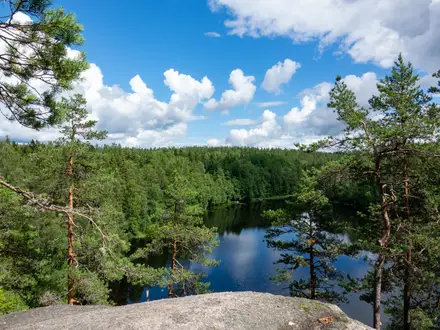
- Hrid Lake (about 1,970 m): A small glacial tarn roughly 300 m by 160 m, with clear water, a tiny islet and forested shores. It is one of Montenegro’s “gorske oci”, or mountain eyes.
- Liqeni i Zanave / Fairy Lake: Local folklore calls it the Lake of Happiness and says it was a hidden bathing pool for forest fairies. Visitors traditionally bathe in the cold water or throw in a coin or piece of jewellery for luck.
- Bajrovica Katun: This seasonal shepherds’ settlement sits on the approach to the lake. Samelova Koliba, also called Samel’s Cottage, can provide food, refreshments and beds when open.
- Accursed Mountains setting: The lake sits beneath Hridski Krs (2,358 m) and Bogicevica (2,374 m). Hridski Krs is a popular extension, while the triple-border summit of Tromedja lies nearby.
- Peaks of the Balkans connection: Hrid Lake lies on the 192 km Peaks of the Balkans route linking Montenegro, Kosovo and Albania. The day hike shares terrain with this trans-frontier long-distance trail.
Challenges to expect
The hiking is moderate, but do not treat it as a park stroll. The access road is rough, the first section is a dirt 4WD track, and the forest path is rocky and root-strewn in places. Waymarking exists but is only moderate, so carry a map or GPS, especially in poor visibility. Snow can linger into late spring; the best season is June to September.
HikeList Score
Hrid Lake Trail scored 79/100 on HikeList's trail-quality metrics.
See score breakdownHide breakdown
- Ideal length 55
- Balanced challenge 100
- Scenery & wildness 85
- Varied terrain 83
- Accommodation 83
- Food & support 61
- Path quality 98
- Season flexibility 76
Computed from length, challenge, scenery & wildness, terrain variety, accommodation, food & support, path quality and season flexibility.
Show more data Show less
- Mountainous
- Forest
- Alpine Meadows
- Dirt
- Rocky
- Root Strewn
- Huts
- Guesthouses
- Hotels
- Family Friendly
- Pet Friendly
- Campsites
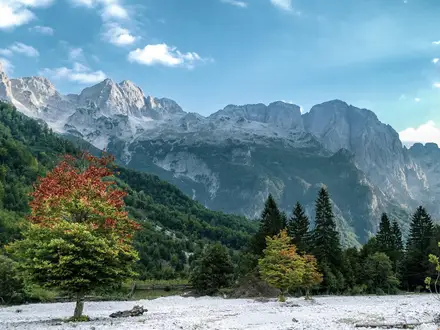
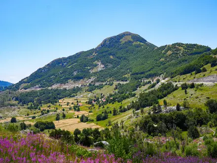
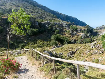
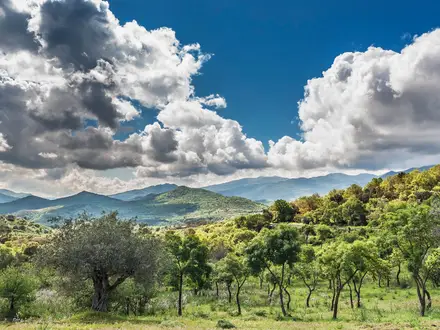
Photos from hikers
Taken on the trail by people who've reviewed Hrid Lake Trail.
From the Babino Polje parking/trailhead, follow the dirt 4WD track for roughly 3.6 km to Bajrovica Katun and Samelova Koliba. Continue on the marked single-track forest path, trail no. 542 from the Bajrovica side, for about 3.2 km to Hrid Lake. Picnic, swim if conditions allow, then return by the same route.
Reviews
How would you rate Hrid Lake Trail?
Tap a star to start your review — you could be the first.