GR13 (Morvan Regional Park)
How would you rate GR13 (Morvan Regional Park)?
Tap a star to share your experience and help other hikers.
GR13 (Morvan Regional Park): Burgundy’s Forest Traverse
HikeList Score
GR13 (Morvan Regional Park) scored 94/100 on HikeList's trail-quality metrics.
See score breakdownHide breakdown
- Ideal length 98
- Balanced challenge 100
- Scenery & wildness 98
- Varied terrain 71
- Accommodation 100
- Food & support 81
- Path quality 98
- Season flexibility 89
Computed from length, challenge, scenery & wildness, terrain variety, accommodation, food & support, path quality and season flexibility.
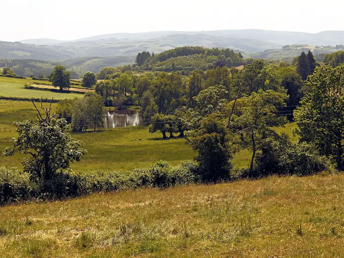
The GR13 through Morvan Regional Nature Park is a 174 km point-to-point hike in Burgundy, France, usually walked in 8 days from Vézelay to Autun. It is a moderate long-distance route: waymarked with red-and-white GR blazes, non-technical, but long enough to demand steady fitness. Expect wooded granite hills, rural lanes, forest tracks, rocky and muddy sections, and cool, wet weather even in summer. It suits hikers wanting a quiet French thru-hike with villages, lakes, forest and Gallo-Roman history.
Route Overview
This listing covers the north-to-south Morvan crossing of the GR13, from UNESCO-listed Vézelay to Autun. The route enters the park near Saint-Père/Vézelay, then links Pierre-Perthuis, the Cure valley, Lormes, Ouroux-en-Morvan, Lac des Settons, Saint-Brisson, Dun-les-Places, Château-Chinon, Glux-en-Glenne, Mont Beuvray / Bibracte and Saint-Léger-sous-Beuvray before Autun. It is a linear trail, so plan start/end logistics rather than a loop. For gentler Burgundy walking, compare the Burgundy Canal Towpath; for another French canal option see the Berry Canal Walk. If you want higher forested mountains, look at the Ballons des Vosges Park Trails.
Morvan History: Timber, Bibracte and the Resistance
The Morvan’s granite uplands were long a poor, forested massif, known for floating oak and beech down the Cure and Yonne to heat Paris; Lac des Settons was created for that timber trade. Mont Beuvray held Bibracte, capital of the Aedui, later abandoned in favour of Autun. In the Second World War, the remote forests sheltered large Maquis groups. Dun-les-Places, on the route, is remembered as a martyr village after a German massacre in June 1944.
Notable highlights
- Vézelay (northern gateway): A UNESCO World Heritage hill town crowned by the Romanesque Basilica of Sainte-Marie-Madeleine, and a historic starting point for Santiago de Compostela pilgrim routes.
- Lac des Settons (forest reservoir): A 366-hectare granite-dammed lake on the River Cure, originally built for the Morvan timber trade and now a swimming, sailing and picnic area near Montsauche-les-Settons.
- Saint-Brisson (park headquarters): Home to the Morvan Regional Park headquarters and the Museum of the Resistance in the Morvan, set around the Maison du Parc grounds.
- Gorges de Narvau (Lormes detour): A short wooded gorge with a waterfall and climbing crags, close to Lormes and easy to add if time allows.
- Haut-Folin (901 m high point): The highest point of the Morvan and Burgundy, in the Saint-Prix forest; the GR13 crosses or passes close to this high ground.
- Mont Beuvray / Bibracte: A wooded 821 m summit holding the Iron Age oppidum of Bibracte, with excavation areas and a modern archaeology museum.
Challenges to expect
The GR13 Morvan section is moderate rather than technical: the main challenge is 174 km of cumulative distance, rolling ascent and variable surfaces. Forest tracks, dirt paths, gravel and rocky sections can become muddy after rain. The Morvan is one of the cooler, wetter parts of inland France, so carry waterproofs even in summer. Accommodation exists in villages and hamlets, but stages need planning.
HikeList Score
GR13 (Morvan Regional Park) scored 94/100 on HikeList's trail-quality metrics.
See score breakdownHide breakdown
- Ideal length 98
- Balanced challenge 100
- Scenery & wildness 98
- Varied terrain 71
- Accommodation 100
- Food & support 81
- Path quality 98
- Season flexibility 89
Computed from length, challenge, scenery & wildness, terrain variety, accommodation, food & support, path quality and season flexibility.
Show more data Show less
- Mountainous
- Forest
- Dirt
- Rocky
- Gravel
- Hotels
- Lodges
- Campsites
- Hostels
- Wild Camping Spots
- Family Friendly
- Pet Friendly
- Water Sources
- Campsites
- Picnic Areas
Download Our Full Guide to GR13 (Morvan Regional Park) FREE!
Get our comprehensive guide to this hike for free. Save it for later reading or print out at home.
In these collections
Photos from hikers
Taken on the trail by people who've reviewed GR13 (Morvan Regional Park).
GR13 (Morvan Regional Park): The Complete Guide
 i
Image by luctheo
i
Image by luctheo The GR13 through the Morvan is a quiet 174 km north-to-south traverse of Burgundy’s granite uplands, linking Vézelay’s UNESCO-listed hill town with Autun via forests, bocage, lakes and high wooded summits. It suits fit walkers who want a waymarked French long-distance route with rural solitude rather than technical mountain terrain, with standout days around Lac des Settons, Haut-Folin — the 901 m high point of Burgundy — and Mont Beuvray / Bibracte before the final descent towards Autun.
What the route asks is steady endurance, good stage planning and a willingness to carry a full pack through a region where services are spread out and muddy tracks are common after rain. This guide covers the 8 stages, daily planning, accommodation, food and water, transport to Vézelay and from Autun, terrain and conditions, and the common mistakes that make this walk harder than it needs to be.
Stage-by-Stage Guide
The GR13 through the Morvan is best treated as an accommodation-led traverse: the path is waymarked, but villages are small, services are uneven and several days have long stretches with no reliable shop. Check accommodation, meal availability and rural opening hours before committing to each stage, especially outside the main summer season and on Sundays.
Stage 1: Vézelay to Chastellux-sur-Cure — 24 km
The first stage is a full day from the hilltop streets of Vézelay into the Cure valley and the northern edge of the Morvan. It begins with a descent from the UNESCO-listed town and the Basilica of Sainte-Marie-Madeleine, then passes Saint-Père before continuing through a mix of farmland, small villages, riverside woodland and quiet lanes.
Underfoot, expect a varied day: bocage tracks, vineyard and field edges, forest paths beside the Cure, gravel, dirt and some road walking. The early open sections can be hot and exposed in summer, so this is not a stage to start short of water. Around Pierre-Perthuis, with its Roman bridge, the route also marks a noticeable transition from limestone country towards the granite Morvan.
Main places and landmarks on or close to the day include Saint-Père, Foissy-lès-Vézelay, Pierre-Perthuis, Domecy-sur-Cure, Pontaubert and Saint-André-en-Morvan before the finish at Chastellux-sur-Cure. The château above the Cure valley is the main landmark at the end of the day.
Food and water: Vézelay is the place to stock up before leaving. Between Vézelay and Chastellux-sur-Cure, services are very limited and hamlets should not be assumed to have shops. Public water points are noted at Foissy-lès-Vézelay and Domecy-sur-Cure, with a cemetery tap at Chastellux-sur-Cure; taps and fountains should still be checked locally before relying on them. Carry a packed lunch.
Accommodation: Chastellux-sur-Cure is small, with limited choices. Options referenced locally include Gîte du Vezelien and Le Chastellux. Book ahead, as this is not a village where it is sensible to arrive without a reservation.
Access and navigation: Vézelay is reached via local transport connections from Avallon/Sermizelles rather than by a major trailhead railway. Chastellux-sur-Cure has road access, but public transport options are limited and should be checked before travelling. Waymarking is generally good, though some farm-track routing in the middle of the stage can feel indirect; follow the red-and-white GR marks rather than cutting across private land.
Warnings: This is a long first day with limited resupply and exposed field sections. In hot weather, leave Vézelay with enough water for several hours. After rain, riverside and shaded woodland paths can be muddy.
Stage 2: Chastellux-sur-Cure to Quarré-les-Tombes — 19 km
Stage 2 is shorter than the opening day, but it is not a throwaway stage. It rolls through a quieter mix of meadows, hamlets and forest, with sections near the Cure and around the Lac du Crescent area. Douglas pine plantations and enclosed bocage give the day a more wooded Morvan character than the approach from Vézelay.
The walking is mostly on rural tracks, forest paths and lanes. There is some road walking near the Lac du Crescent area, and one awkward or confused section has been noted where careful attention to the waymarks is needed, especially if tired or walking in poor visibility.
The main features are the departing views back around Chastellux-sur-Cure, the Lac du Crescent area and the steady approach to Quarré-les-Tombes, the best-serviced village in the northern part of this itinerary.
Food and water: Do not assume there are shops en route. Quarré-les-Tombes is the key resupply point, with a bakery, butcher, grocer, tobacco shop, chocolaterie and tourist office. The bakery Quarré de Chocolat is on Place de l'Église, and the tourist office is on rue du grand puit. Shop hours in rural Burgundy can be restrictive, particularly on Sundays and Mondays; confirm opening times before relying on them.
Accommodation: Quarré-les-Tombes has a better range than most intermediate stops, including hotels such as L'Hôtel du Nord, Logis le Morvan and Auberge de l'Atre, plus gîte options. There is also a motorhome/camping aire with water. Even here, booking ahead is still advisable during holiday periods.
Access and navigation: Quarré-les-Tombes has road access and is a realistic place to pause or rework an itinerary, but local public transport is limited. Any MOBIGO or taxi option should be checked before travelling. Stay close to the GR blazes through the less obvious forest and lane junctions.
Warnings: The shorter distance can tempt walkers into a late start, but services at the finish may close early or not open every day. Plan food before leaving Chastellux-sur-Cure or by confirmed opening times at Quarré-les-Tombes.
Stage 3: Quarré-les-Tombes to Saint-Agnan — 15 km
This is the shortest official stage and gives some breathing space after the first two days. It is mainly a forest and memorial-history stage, passing through mature woodland around the Forêt de Breuil-Chenue and the martyr village of Dun-les-Places before continuing towards Gouloux and Saint-Agnan.
Paths are generally well waymarked and largely non-technical, with forest tracks and shaded paths forming much of the day. In wet weather, expect soft ground and muddy sections under trees. The deer park area near the Breuil-Chenue forest and the wooded approach to the Saut de Gouloux give the stage a more enclosed feel than the farmland north of Quarré-les-Tombes.
Dun-les-Places is an important stop: the village is remembered for the German massacre of June 1944, the worst martyred village in Burgundy. Later, the route passes near the Saut de Gouloux, a 10-metre waterfall, and close to the Dolmen de Chevresse and the Champgazon peat bogs. Saint-Brisson, with the Maison du Parc, the Museum of the Resistance in the Morvan, herbularium, arboretum, bistro, local produce shop and tourist office, lies about 2–3 km off the main GR13 and makes a worthwhile but distance-adding detour.
Food and water: Stock up in Quarré-les-Tombes before leaving. Café-Restaurant Le Saut de Gouloux can be useful mid-stage, but opening should be checked before relying on it. Saint-Agnan and the Lac de Saint-Agnan area have limited services; do not count on a full resupply without prior confirmation.
Accommodation: Around Saint-Agnan and Lac de Saint-Agnan there are gîte and chambre d'hôtes options. Chalets Alain Marchand near Gouloux are another referenced option in the wider stage area. Availability is limited, so reserve ahead.
Access and navigation: Road access exists at Dun-les-Places, Gouloux and Saint-Agnan, but public transport should not be assumed. Navigation is usually straightforward in the forest, though the Saint-Brisson detour needs separate time and distance planning if taken.
Warnings: The short distance makes this a good day for visiting memorial and park sites, but the detour to Saint-Brisson changes the character of the day. Confirm café, museum and accommodation opening times before building the stage around them.
Stage 4: Saint-Agnan to Lac des Settons — 23 km
Stage 4 moves deeper into the central Morvan, linking forest, bocage and lake country. The day continues through rolling wooded terrain, with a gradual sense of entering the higher, wetter interior of the park before reaching Lac des Settons.
The surfaces are typical Morvan: forest tracks, dirt paths, gravel and quiet rural lanes. After rain, expect mud and standing water in shaded sections. The route passes through or near Gouloux and Montsauche-les-Settons before arriving at Lac des Settons, a 360-hectare reservoir on the River Cure, built with a granite dam for the historic timber-floating trade. The lake sits at around 583 m and is bordered by pines; a separate marked circuit of about 15 km runs around the shoreline.
Highlights include the approach to Lac des Settons, the pine-fringed lake environment and the wider Resistance history of the area. The lake is also one of the more sociable points on the route, with swimming, sailing and picnic areas in season.
Food and water: Montsauche-les-Settons is the practical service village for this stage, with a bakery, small supermarket and other services. Around Lac des Settons there are lakeside cafés, restaurants and accommodation, but seasonal opening and weekend pressure matter. Check opening hours before depending on a late meal or shop.
Accommodation: The Lac des Settons area has more choice than many Morvan hamlets, including lakeside gîte d'étape options such as Suite Panoramique Vigie, camping and cabin-style accommodation such as La Cabanétape. Summer demand can be high, so book well ahead.
Access and navigation: The lake and Montsauche-les-Settons have road access and are among the more practical places on the route for joining, leaving or meeting support by car. Public transport is still not frequent enough to treat as a casual bail-out option; check MOBIGO timetables before travelling. Navigation is generally straightforward on established forest paths, with a lake footbridge crossing noted on the approach.
Warnings: Rural Sunday hours can affect Montsauche-les-Settons shops. In summer, accommodation at the lake may be full even when smaller inland villages are quiet. Carry enough food to reach the lake without relying on intermediate hamlets.
Stage 5: Lac des Settons to Anost — 22 km
This stage leaves the lake country and continues south through mixed forest, bocage and valley terrain. Compared with the very hard day that follows, it is more moderate, but it still requires a full walking day with limited services between the start and finish.
The route passes through or near Planchez and Moux-en-Morvan, using forested ridges, rural lanes and river-valley paths. The gradients are generally easier than on the Anost to Glux-en-Glenne stage, but the ground can still be slow after rain. The walking is quiet and enclosed for long stretches, with fewer obvious resupply points than the map might suggest.
Anost is a useful and characterful stop, known for Morvan oral heritage and galvachers history. The Maison du Patrimoine Oral and the Maison des Galvachers reflect local traditions, including the history of Morvan itinerant lumberjacks. Above the village, the wooded hilltop statue of Notre-Dame de l'Aillant (erected 1878) is a viewpoint that commemorates Anost being spared by German troops on 14–16 July 1944. Resistance history remains present in the wider area, including Maquis Socrate memorial sites.
Food and water: Carry food from Lac des Settons or Montsauche-les-Settons. There are gaps in reliable services before Anost, and rural opening hours in small hamlets should not be relied upon. At Anost, services include restaurants such as Ah! nos pizz' and La Galvache, and village water.
Accommodation: Anost has practical overnight options including Hôtel Fortin and the municipal gîte d'étape in the converted school building. Plan this night carefully: it is the launch point for the hardest stage of the route, so an early breakfast or packed meal arrangements are worth sorting on arrival.
Access and navigation: Anost has road access, but local public transport should be checked before travelling. The GR waymarking is generally reliable on this stage. In forest, vegetation can obscure marks, so carrying the official trace or IGN mapping remains sensible.
Warnings: Do not under-plan this day simply because the gradients are easier than Stage 6. Food gaps are real, and a late arrival in Anost can make it difficult to prepare properly for the next morning.
Stage 6: Anost to Glux-en-Glenne — 30 km
Stage 6 is the crux of the Vézelay to Autun traverse: the longest day, the biggest physical effort and the most committing terrain. It is around 30 km with roughly 1,000–1,100 m of climbing and can take about 8 hours 45 minutes of walking time before breaks. Many walkers should plan for 9 hours or more on the move.
The day has three major efforts. First comes the steep forest climb towards Mont Robert, reached after the opening uphill from Anost; this area also marks roughly 100 km walked from Vézelay. Later, the Gorges de la Canche provide the most demanding natural section of the route, with a Natura 2000 gorge, cascades, wet rock, water crossings and steep, hands-on ground where secure footing matters. A flatter section on the Chemin du Tacot, an old railway track, gives some relief before the final high-ground push towards Haut-Folin.
Haut-Folin, at 901 m, is the highest point of the Morvan and Burgundy. It lies in the Saint-Prix forest on the Seine-Loire watershed, with radio towers visible from a distance. The summit area is wooded and not as ceremonially marked as some hikers expect, so treat it as a high crossing rather than a guaranteed viewpoint.
Food and water: This stage must be provisioned in advance. A cemetery tap is noted at Roussillon-en-Morvan, around mid-stage, and Auberge de Roussillon can be a useful stop if open. Do not depend on finding food before Glux-en-Glenne without checking opening times. Carry a packed lunch, emergency food and more water than usual.
Accommodation: Glux-en-Glenne is a small high village, noted as the highest village in Burgundy. Accommodation options include Plumes de Mouton et Cie, around 4 km before the village centre, and Gîte du Mont Beuvray. Bivouac has been noted as possible at a picnic area near the village, but regulations, land ownership and current local rules should be checked before relying on it.
Access and navigation: Road access exists at points such as Roussillon-en-Morvan and Glux-en-Glenne, but this is not a stage with easy public-transport escape options. Navigation remains on GR waymarks, but the terrain itself is the challenge. The Gorges de la Canche require particular care; official signs recommend boots, and sturdy footwear is strongly advised for the whole day.
Warnings: Do not attempt this stage in bad weather, poor visibility or when already exhausted. The gorge can be slippery and awkward with a heavy pack, and water crossings and wet rock increase the risk of a fall. Start early, allow generous time and have a realistic plan if progress is slower than expected.
Stage 7: Glux-en-Glenne to Saint-Léger-sous-Beuvray — 14 km
After the previous day, Stage 7 is deliberately short, but it still includes one of the defining climbs of the route: Mont Beuvray. The day begins with forested walking from Glux-en-Glenne before climbing to the 821 m wooded summit and the archaeological site of Bibracte.
Mont Beuvray was the site of Bibracte, the Iron Age oppidum and capital of the Aedui tribe, founded in the late 2nd century BC. The summit area has excavation zones, a separately signed rampart circuit and the Musée de Bibracte. The beech forest is also notable for queules, trees historically shaped and woven by farmers to mark agricultural boundaries. From the summit area, the route descends to Saint-Léger-sous-Beuvray.
The stage is mostly on forest paths and tracks, with the climb and descent making it feel more substantial than the distance suggests, particularly on tired legs. Views from Mont Beuvray are among the best on the southern half of the traverse when conditions are clear.
Food and water: The Musée de Bibracte has a café/restaurant and can be a useful mid-stage stop, but opening is seasonal and should be checked before travelling. Carry enough food and water to complete the stage if the museum facilities are closed.
Accommodation: Saint-Léger-sous-Beuvray has village accommodation options, including Chambre d'hôte du Petit Montigny. As with other small stops, book ahead rather than assuming walk-in availability.
Access and navigation: Mont Beuvray and Saint-Léger-sous-Beuvray have road access, but public transport should be checked in advance. Around Bibracte, distinguish the GR from the museum and rampart circuits, which are signed separately and can easily add time if followed unintentionally.
Warnings: The short distance is useful recovery, but cumulative fatigue from Stage 6 is often the main issue. If planning to visit the museum properly, allow enough time and check seasonal opening hours.
Stage 8: Saint-Léger-sous-Beuvray to Autun — 27 km
The final stage is long again, descending from the southern flanks of the Morvan through forest, farmland and quiet lanes towards the Autunois basin. The route gradually leaves the granite uplands behind and approaches Autun, the historic Gallo-Roman town of Augustodunum.
Underfoot, expect the familiar mix of woodland paths, rural tracks, gravel and lanes. The navigation is generally straightforward on the waymarked GR, and town signage becomes more relevant as Autun nears. After wet weather, forest and farm sections can still be muddy, so keep proper footwear for the final day rather than treating it as an easy walk-out.
Autun provides a strong finish, with Roman remains including the theatre, Porte Saint-André and Porte d'Arroux, as well as the Cathedral of Saint-Lazare and its Gislebertus tympanum. For walkers continuing on pilgrimage routes, the GR131 heads south towards Cluny, but that is a separate onward itinerary.
Food and water: Carry supplies from Saint-Léger-sous-Beuvray unless a specific open stop has been confirmed on the final approach. Autun is a full-service town with bakeries, supermarkets, restaurants and hotels.
Accommodation: Autun has a wider range of hotels, gîtes and chambres d'hôtes than any intermediate stage stop. Booking ahead is still sensible in peak season or if arriving late after the 27 km stage. The Autun tourist office can help with local accommodation information.
Access and transport from the finish: Autun should not be treated as a direct rail finish. The Étang-sur-Arroux–Autun railway has been closed since 2020, and onward travel uses an SNCF replacement bus to Étang-sur-Arroux station. From Étang-sur-Arroux, TER trains connect towards Le Creusot, Nevers and Dijon. MOBIGO is the regional bus brand in Burgundy. Check MOBIGO and SNCF timetables before finishing, and allow enough time for the bus connection.
Warnings: This is the longest day since Anost to Glux-en-Glenne. Start early if aiming to leave Autun the same day, as the last useful bus connection may be too early for a relaxed late finish. Do not plan onward travel on the assumption of a train departing directly from Autun.
Recommended Itinerary
Standard 8-day itinerary
This is the most practical schedule for the Vézelay-to-Autun GR13 traverse: it follows the established 8-stage line, keeps overnight stops in recognised villages or accommodation clusters, and avoids making the already long Morvan days harder than necessary. Book accommodation before committing to dates, especially at Chastellux-sur-Cure, Saint-Agnan, Glux-en-Glenne and outside the main summer season.
| Day | From | To | Approx. distance | Why this stage makes sense | Services/accommodation notes |
|---|---|---|---|---|---|
| 1 | Vézelay | Chastellux-sur-Cure | 24 km | A substantial opening day that gets the route out of the Vézelay limestone country and into the Morvan approach via Saint-Père, Pontaubert and the Cure valley. The distance is already meaningful, so start early rather than treating it as a warm-up. | Vézelay has the best pre-walk services. Chastellux-sur-Cure is small, with limited options; the gîte d'étape and nearby guest accommodation should be reserved. Carry lunch and snacks, as there are no large village services to rely on during the stage. |
| 2 | Chastellux-sur-Cure | Quarré-les-Tombes | 19 km | A more manageable second day after the long start, passing towards Lac du Crescent and Dun-les-Places before reaching one of the better service villages on the northern half of the route. | Quarré-les-Tombes has a boulangerie, épicerie, tourist information office and a Sunday morning market. It is a sensible place to restock before the quieter central stages. Accommodation is available in the village, but should still be booked ahead. |
| 3 | Quarré-les-Tombes | Saint-Agnan | 15 km | The shortest northern-stage day and a useful recovery point. It also leaves time for Saint-Brisson, where the Maison du Parc and the Museum of the Resistance in the Morvan make a worthwhile stop. | Saint-Agnan has accommodation around the lake, including gîte and auberge-style options, but village services are limited and no general shop should be assumed. Nearby Saulieu has fuller services but is off-route. |
| 4 | Saint-Agnan | Lac des Settons | 23 km | A full but balanced day through the heart of the Morvan, with Gouloux and the Saut de Gouloux as useful landmarks before reaching the Lac des Settons area. | The lake and nearby Montsauche-les-Settons form an important service point, with hotels, restaurants and lake accommodation. Some lakeside services may be seasonal, so check opening dates before booking. |
| 5 | Lac des Settons | Anost | 22 km | Keeps the middle of the walk steady without overloading the legs before the hardest stage. The route crosses quieter upland and wetland country, including the Champgazon peat bog area. | Anost has a gîte d'étape, hotel/restaurant options and village services, though year-round opening should not be assumed. Confirm meals when booking, particularly outside July and August. |
| 6 | Anost | Glux-en-Glenne | 30 km | The longest and most demanding day. It takes in steeper terrain around the Gorges de la Canche and crosses the high ground of Haut-Folin, at 901 m the highest point of the Morvan and Burgundy. Allow a full day, especially in wet conditions. | Glux-en-Glenne is a small high village with limited fallback options. Accommodation includes farm-stay, gîte and chambres d’hôtes options, but food and evening meals must be arranged in advance. This is the key booking bottleneck of the route. |
| 7 | Glux-en-Glenne | Saint-Léger-sous-Beuvray | 14 km | A deliberately short stage after the 30 km day. It gives proper time for Mont Beuvray and Bibracte rather than forcing the archaeological site into a rushed pass-through. | Saint-Léger-sous-Beuvray has useful village services: bakery, restaurants/bars, pharmacy, petrol station and a Thursday morning market. It is a good place to prepare for the long final day. |
| 8 | Saint-Léger-sous-Beuvray | Autun | 27 km | A long finishing stage through Morvan forest and down to Autun. The distance is significant, so avoid leaving too late if onward transport is planned the same day. | Autun has full town services: hotels, restaurants, supermarkets and pharmacy. For onward travel, use the SNCF replacement bus to Étang-sur-Arroux, then TER connections; the Autun rail line has been closed since 2020. Check current MOBIGO/SNCF timetables before travel. |
Slower variant: 9–10 days
A slower schedule suits walkers carrying heavier packs, those wanting more time at Lac des Settons, Haut-Folin and Bibracte, or anyone not comfortable with repeated 20 km-plus days on muddy upland tracks. The best places to soften the route are the two longest stages:
| Adjustment | How it helps | Planning caution |
|---|---|---|
| Split Day 6 between Anost and Glux-en-Glenne | Reduces the hardest 30 km stage, which includes steeper ground and the Haut-Folin high point. | Intermediate accommodation is scattered and cannot be assumed. Check official mapping and book a specific bed before relying on this split. |
| Split Day 8 between Saint-Léger-sous-Beuvray and Autun | Makes the 27 km final day easier and reduces the risk of missing onward transport from Autun. | Only plan this if accommodation has been secured on or close to the route. This should be checked before travelling. |
| Add a rest/short day around Lac des Settons or Bibracte | Gives more time for the lake area or the Mont Beuvray/Bibracte visit without compressing the walking. | Seasonal opening matters around the lake; confirm accommodation and meals before booking the rest day. |
For a 9–10 day version, keep the fixed service villages in the standard itinerary and add extra nights only where accommodation is confirmed. The Morvan has plenty of hamlets, but not every hamlet has food, shops or year-round lodging.
Faster variant: 6–7 days
A faster itinerary is only sensible for strong, self-sufficient walkers who are comfortable with 30 km days on rolling, sometimes muddy terrain while carrying their own pack. There is no established baggage-transfer service for this route.
| Option | Approx. effect | Who it suits | Caution |
|---|---|---|---|
| Combine Day 3 and Day 4: Quarré-les-Tombes to Lac des Settons | Creates a long day of about 38 km and removes one overnight stop. | Very fit walkers who can start early and maintain pace through a full day. | This skips the natural recovery stage at Saint-Agnan and leaves little margin for poor weather or slow surfaces. |
| Keep Day 6 as standard rather than trying to lengthen it | Maintains the 30 km Anost to Glux-en-Glenne crossing as the main hard day. | Most fast hikers. | Extending this stage is not recommended unless accommodation and timing are fully controlled. |
| Combine Day 7 and Day 8: Glux-en-Glenne to Autun | About 41 km if walked in one push. | Only exceptionally fit walkers with long-day experience. | This sacrifices time at Bibracte and creates a very demanding final day before uncertain onward bus/rail connections. For most walkers, it is better to keep Saint-Léger-sous-Beuvray as the overnight stop. |
The most realistic 7-day version is to combine the short Quarré-les-Tombes to Saint-Agnan stage with the following stage to Lac des Settons, provided accommodation at the lake is booked and the weather forecast is reasonable. A 6-day schedule is possible only by adding another very long day and is a poor choice for anyone wanting a reliable, enjoyable traverse rather than an endurance exercise.
Planning the Route
How many days to allow
Most walkers should plan on 8 walking days, matching the established Vézelay-to-Autun stage structure. The daily distances are uneven: some days are relatively short, but others are long enough that accommodation, food and weather need to be arranged before setting out.
A 9–10 day plan is often more comfortable if you want time for Vézelay, Lac des Settons, Bibracte or Autun, or if you prefer shorter days with a lighter margin for bad weather. Fast, fit walkers carrying camping gear can compress the route to 7 days by combining shorter stages, but this is less practical if relying on booked beds and village services.
This HikeList route follows the Vézelay to Autun line. Other bodies describe slightly different GR13 variants, including Avallon-based or shorter routes ending before Autun, so check that maps, GPX files and accommodation bookings all match the same itinerary.
Stages are dictated by accommodation
The Morvan is rural, with long stretches between villages. This is not a route where you can reliably walk until tired and then find a bed nearby. The practical stage ends are the accommodation nodes: Chastellux-sur-Cure, Quarré-les-Tombes, Saint-Agnan, Lac des Settons / Montsauche-les-Settons, Anost, Glux-en-Glenne, Saint-Léger-sous-Beuvray and Autun.
| Route section | Planning note |
|---|---|
| Vézelay to Chastellux-sur-Cure | A full first day from a well-served start into a much smaller village. Book ahead rather than assuming availability on arrival. |
| Chastellux-sur-Cure to Quarré-les-Tombes | More manageable distance, ending in one of the better intermediate service points. |
| Quarré-les-Tombes to Saint-Agnan | Shorter day, but Saint-Agnan is very small, so accommodation and food need checking in advance. |
| Saint-Agnan to Lac des Settons | Lakeside accommodation is seasonal and can be busy in summer, especially around July and August. |
| Lac des Settons to Anost | A normal full walking day; Anost has more options than the smallest villages but still benefits from advance booking. |
| Anost to Glux-en-Glenne | The key planning constraint of the route: around 30 km and crossing the high ground near Haut-Folin. Accommodation at or near Glux-en-Glenne is limited, so book this night first. |
| Glux-en-Glenne to Saint-Léger-sous-Beuvray | A short recovery stage after Haut-Folin and before the final day to Autun. Some strong walkers combine onward, but this creates a very long finish. |
| Saint-Léger-sous-Beuvray to Autun | A long final day into a larger town with a full range of accommodation. |
The most important booking is the night around Glux-en-Glenne. Options are limited, with accommodation such as Plumes de Mouton et Cie around 4 km before the village and Gîte du Mont Beuvray serving this part of the route. Availability, opening periods and exact access should be checked before travelling.
Fast or slow?
The best pace for most walkers is steady rather than fast. The terrain is non-technical, but the cumulative walking is significant and the surfaces can be slow after rain. The headline ascent figure is often given at roughly 3,000 m, while GPS-based profiles for the full Vézelay-to-Autun line are closer to 4,800 m of cumulative climb. Either way, the route is hillier than the daily distances alone suggest.
A slower pace also makes the route easier logistically. It gives more time for village opening hours, accommodation check-in windows, wet-weather delays and visits such as the Maison du Parc at Saint-Brisson, Dun-les-Places, Lac des Settons and Bibracte. Non-French speakers may also appreciate an extra day, as English is not universally spoken in small Morvan villages.
Shortening, extending and rest days
The cleanest way to shorten the hike is to start at Quarré-les-Tombes instead of Vézelay, skipping the first two stages and making a 6-day walk across the central and southern Morvan. Quarré-les-Tombes can be reached by MOBIGO bus from Avallon, but timetables should be checked before travelling.
There is no simple mid-route shortcut that dramatically reduces the walk once you are in the central Morvan between Saint-Agnan and Glux-en-Glenne. In that section, the practical options are usually to continue to the next booked stop, retrace to a previous roadhead, or arrange local transport.
Good places for a rest or half-day are:
- Vézelay before starting, especially if arriving late by public transport.
- Lac des Settons, where summer accommodation and services are concentrated around the lake.
- Autun, which has the easiest end-of-route logistics and the broadest accommodation choice.
For an extension, some walkers continue from Autun towards Cluny on the onward pilgrimage line, adding roughly 111 km over 4–5 stages. Treat this as a separate route with its own accommodation and transport planning.
Section hiking
The GR13 through the Morvan works well as a section hike, particularly for walkers with a car. Many stage ends have road access, and public transport can be useful from the northern and southern ends, though it is limited away from Avallon and Autun.
Practical section choices include:
| Section | Why it works |
|---|---|
| Quarré-les-Tombes to Glux-en-Glenne over 3–4 days | Covers the central Morvan: forest, lakes, Saint-Agnan, Lac des Settons, Anost and the approach to Haut-Folin. |
| Lac des Settons to Anost, then towards Haut-Folin | A shorter taste of the high Morvan, useful if time is limited. |
| Glux-en-Glenne to Autun | A strong southern section taking in Mont Beuvray / Bibracte before finishing in Autun. |
For car-based section hiking, the simplest method is usually to park at the intended finish and arrange a taxi or bus to the start. Quarré-les-Tombes and Montsauche-les-Settons have car parks. Public-transport section hiking is more awkward but feasible from the Avallon side in the north and the Autun / Étang-sur-Arroux side in the south.
What to plan first
Accommodation
Book the full route ahead, especially for weekends and July–August. Rural gîtes d’étape and chambres d’hôtes often have limited capacity, and some villages have very few alternatives. Do not leave Chastellux-sur-Cure, Saint-Agnan, Glux-en-Glenne or Saint-Léger-sous-Beuvray to chance.
Food and resupply
Food planning matters as much as bed planning. Village shops, cafés and restaurants may have limited opening days, seasonal hours or closures. This should be checked before travelling, especially for Chastellux-sur-Cure and Glux-en-Glenne. Carry reserve snacks every day and avoid relying on a single lunch stop being open.
Water should be topped up whenever a reliable opportunity appears, especially before longer forest and upland sections. Do not assume that natural water encountered on route is drinkable without treatment.
Transport
There is no dedicated trail shuttle and no widely advertised baggage-transfer service for this route, so most walkers carry their own packs. Plan both ends before booking accommodation.
Northern access is normally via Avallon by TER, then local MOBIGO bus links towards Vézelay. Southern exit is via Autun, but the Étang-sur-Arroux–Autun railway has been closed since 2020; Autun is served by SNCF replacement bus connecting with TER trains at Étang-sur-Arroux for onward travel towards Nevers, Le Creusot and Dijon. Timetables should be checked before travelling.
Navigation
The GR13 is waymarked with red-and-white GR blazes, but a map or GPX is still essential. Download the route from the Parc du Morvan hiking portal or MonGR before setting out, as mobile reception can be unreliable in rural and forested areas.
Direction markers differ by walking direction: red hiker symbols on a white background indicate the Vézelay-to-Autun direction, while white symbols on a red background indicate the reverse. The FFRandonnée topoguide and IGN TOP25 mapping are the best print references.
Weather
The Morvan is one of the cooler, wetter parts of inland France. Waterproofs are needed even in summer, and muddy paths are common after rain. Check the forecast carefully before the Anost to Glux-en-Glenne stage, which crosses the high ground around Haut-Folin and is the most exposed part of the route.
Permits and camping
No permit or fee is required to walk the GR13 through the Parc naturel régional du Morvan. It is a regional natural park, not a national park with entry controls.
Bivouac-style camping is possible in some forest areas, but local rules, fire restrictions and land access should be checked before relying on it. Fires may be restricted or banned in dry conditions.
Towns, Villages and Overnight Stops
Accommodation on the GR13 through the Morvan is usable but unevenly spaced. The reliable planning hubs are Vézelay, Quarré-les-Tombes, Lac des Settons / Montsauche-les-Settons, Anost and Autun. Chastellux-sur-Cure, Saint-Agnan, Glux-en-Glenne and Saint-Léger-sous-Beuvray are quieter overnight stops where advance booking, meals at the gîte or hotel, and carrying spare food matter.
Rural opening hours are a real constraint: shops commonly close over lunch and may be closed on Sundays or Mondays. Always check opening days before relying on a village shop, bakery or restaurant, and carry emergency snacks between stages.
Vézelay
Vézelay is the northern start for this HikeList itinerary and the best place to spend the night before setting out. It is a well-served hill town with hotels, gîtes, chambres d'hôtes, restaurants, bars and small shops, particularly around rue Saint-Étienne and rue Saint-Pierre.
Accommodation choice is good by Morvan standards, but it is also a popular stop for pilgrims and visitors to the Basilica of Sainte-Marie-Madeleine, so booking ahead is sensible in summer and at weekends. Hotels include Les Glycines and Le Compostelle; restaurants include Le Relais du Morvan and La Terrasse.
There is no train station in Vézelay. Access is by MOBIGO bus from Avallon, which has a TER station, or from Sermizelles-Vézelay station. This makes Vézelay practical for arrival, but not a place to leave transport arrangements until the last minute. The Office de Tourisme du Grand Vézelay can help with local information: +33 (0)3 86 33 23 69.
Saint-Père
Saint-Père sits below Vézelay early on Stage 1, roughly 3 km from the start. It is useful if accommodation in Vézelay is full or if a walker wants a lower-key first night close to the route.
There is municipal camping in the village, and the church of Notre-Dame de Saint-Père and the nearby Fontaines Salées archaeological site make it more than just a transit point. Village services are limited, so most food planning should still be done in Vézelay.
Pontaubert
Pontaubert is a small village on the Cousin river between Vézelay and Chastellux-sur-Cure. It is mainly a Stage 1 transit point rather than a natural overnight stop for the standard 8-day itinerary.
The key hiker-relevant option is Le Moulin des Templiers, a hotel-restaurant on the river. Shops are limited, so do not treat Pontaubert as a resupply point unless current opening details have been checked before travelling.
Chastellux-sur-Cure
Chastellux-sur-Cure is the standard end of Stage 1, after about 24 km from Vézelay. It is a small village above the Cure gorges, with the Château de Chastellux overlooking the river.
This is a practical overnight only if accommodation and food are arranged in advance. The village has a gîte d'étape at 22 rue de la Croix, Chastellux-sur-Cure 89630, tel. 03 86 34 22 71 / 06 82 18 83 38. There are no significant shops or restaurants in the village itself, so self-catering supplies, a pre-booked meal or gîte catering should be organised before arrival.
There is no useful public transport link for a typical thru-hiker here. Treat Chastellux-sur-Cure as a quiet end-of-stage stop, not a service centre.
Quarré-les-Tombes
Quarré-les-Tombes is the end of Stage 2 and one of the most useful villages on the northern half of the GR13. It is more service-rich than most Morvan settlements on this route, making it a good place to restock and reset after the first two days.
Hiker services include a bakery, butcher, charcuterie-delicatessen options, grocery store, pharmacy, bar, pizzeria and wine bar. Accommodation includes Hotel-Restaurant Le Morvan and Auberge de l'Atre, alongside other local options. It is a sensible place to book a comfortable overnight rather than relying on small hamlet accommodation later.
The village has no train or regular trail-specific transport link; road access is via local roads. Its unusual stone sarcophagi around the church are worth a short look, but the main planning value is food, pharmacy access and a reliable overnight.
Dun-les-Places
Dun-les-Places lies between the Quarré-les-Tombes and Saint-Agnan section of the route area. It is a small Nièvre village with notable wartime significance as a martyr village, remembered for the German massacre of June 1944.
For walkers, it can be useful as a food or accommodation back-up if the stage plan is adjusted. Services include a bakery, restaurant and small grocery, though opening days should be checked. Accommodation includes Chalet du Montal, Longère Morvandelle on the GR13, and various gîtes.
Dun-les-Places is also a local walking base, with marked trails from the village. Do not assume onward public transport from here; this should be checked before travelling.
Saint-Brisson
Saint-Brisson is important because it is home to the Maison du Parc, the headquarters of the Morvan Regional Natural Park, close to the GR13. It is one of the best information stops on the route rather than a standard overnight on the 8-day schedule.
The Maison du Parc complex includes the park tourist office, documentation centre, museums including the Museum of the Resistance in the Morvan, a bistro, shop selling local and organic products, and a bookshop. The 40-hectare grounds include ponds, trails, a sensory path and a bivouac area.
Usual opening is April to November, with longer daily hours in July and August, but times should be checked before relying on the bistro, shop or visitor facilities. Contact: [email protected] / 03 86 78 79 00.
Saint-Agnan
Saint-Agnan is the end of Stage 3, after the shortest official day from Quarré-les-Tombes. It is a quiet hamlet near the Lac de Saint-Agnan reservoir and works mainly as a peaceful overnight stop rather than a service village.
Accommodation options are limited and should be booked before starting the trail. Food availability is also limited, so carry dinner or confirm whether the accommodation provides meals. This is not a place to arrive expecting a shop, restaurant choice or late booking flexibility.
Gouloux
Gouloux is on the route between Saint-Agnan and Lac des Settons. It is best treated as a daytime stop, particularly for the Saut de Gouloux waterfall on the Caillot stream, where there is a picnic area.
The Saboterie Marchand, a traditional wooden clog workshop, is a useful cultural stop if opening times match the walking day. Services are small-scale, so Gouloux should not be planned as a major resupply or overnight unless current accommodation and food arrangements have been checked.
Lac des Settons / Montsauche-les-Settons
Lac des Settons is the end of Stage 4 and one of the strongest accommodation areas on the whole route. The GR13 passes along or near the shore of the 360-hectare reservoir, while Montsauche-les-Settons village sits about 3 km from the lake.
This is the best-serviced middle-section overnight. Around the lake are multiple campsites, including Plage des Settons and Les Mésanges, plus La Cabane Étape at the Activital outdoor centre. Other options include Les Grillons du Morvan, gîtes and chambres d'hôtes. Montsauche-les-Settons has essential services including shops, pharmacy, tourist office at the Maison des Grands Lacs and post office.
The lake is also a busy outdoor hub, with swimming, sailing, canoeing and mountain biking, so summer accommodation should be booked ahead. Tourist contact: [email protected] / +33 3 86 22 82 74.
Anost
Anost is the end of Stage 5 and the most useful service village before the high southern Morvan. It is a particularly important resupply point because the following stage to Glux-en-Glenne is the longest on the itinerary.
Services include a bakery, butcher, grocery, pharmacy, ATM, petrol station, café, restaurant and newsstand. Accommodation includes Gîte Étape d'Anost, tel. +33 7 61 64 20 20, Hôtel Fortin and Vacances en Morvan.
Anost is also a walking and mountain-bike base, with a large network of marked trails, but GR13 hikers should focus on practical preparation here: buy lunch and snacks for the next day, confirm dinner at Glux-en-Glenne, and leave early for the 30 km stage.
Glux-en-Glenne
Glux-en-Glenne is the end of Stage 6, after the longest day of the route from Anost. It is a very small upland village between Mont Beuvray, Prénelay and the Haut-Folin massif, with an average altitude of about 660 m.
Accommodation is available but limited. Options include Plumes de Mouton et Cie, Gîte du Mont Beuvray and group accommodation. Book in advance and confirm whether evening meals are available, as village shops and services are very limited.
This is not a resupply village. Carry food from Anost, especially if arriving late after the long stage. Its location on the edge of the Saint-Prix forest makes it a strong walking stop, but logistically it is a remote rural hamlet.
Haut-Folin / Saint-Prix forest
Haut-Folin is the high point of the GR13 Morvan traverse at 901 m, in the Bois du Roi within the Forêt Domaniale de Saint-Prix. The route crosses this remote forested high ground on the Seine-Loire watershed.
There are no village services, cafés or shops at the high point. It should be planned as an exposed upland forest section where weather, mud and temperature can be less forgiving than in the lower villages. Carry enough water, food and waterproof layers before leaving your overnight stop.
Saint-Prix village is nearby and has a gîte, but it is not the standard overnight stop on the 8-day Vézelay-to-Autun itinerary. Any alternative-stage use of Saint-Prix should be checked and booked before travelling.
Mont Beuvray / Bibracte
Mont Beuvray is the other major summit on the southern GR13, rising to 821 m and holding the Iron Age oppidum of Bibracte. The route crosses the wooded summit area before the descent towards Saint-Léger-sous-Beuvray and, later, Autun.
There is no overnight accommodation on the summit itself. The Bibracte site has practical visitor facilities, including lockers, restrooms, picnic tables, bike racks and parking, and the museum area has a café/restaurant in season. Museum and catering opening should be checked before relying on them.
For many walkers this is the main historical stop of the final part of the route. It is still a hill stage, so allow time for both the climb and any museum visit rather than treating it as a quick roadside attraction.
Saint-Léger-sous-Beuvray
Saint-Léger-sous-Beuvray is the standard end of Stage 7, at the foot of Mont Beuvray. It is a small working village and a good final overnight before the 27 km walk into Autun.
Services include a bakery and local produce shops. Accommodation includes Hôtel-Restaurant du Morvan, La Maison du Beuvray group gîte, and Gîtes de France rentals such as Gîte n°1843 and Gîte de la Basse Porte. As with other small Morvan villages, book ahead and confirm meal arrangements.
Bibracte is about 6 km away uphill on Mont Beuvray, so many walkers visit it on the approach to Saint-Léger-sous-Beuvray rather than adding an out-and-back after arrival.
Autun
Autun is the southern finish of the Vézelay-to-Autun GR13 itinerary and the first full-service town after the rural Morvan stages. It has a wide range of restaurants, bars, shops, supermarkets, pharmacies, hotels, gîtes and chambres d'hôtes, making it the easiest place to recover, wash kit and organise onward travel.
Accommodation options include Hôtel le Terminus et son restaurant Côte à Côte, Pied à Terre Appart'hôtels, Contact Hotels near the bus/rail area, and various guest accommodation. Staying overnight in Autun after finishing is strongly recommended, especially if arrival is late in the day after the 27 km final stage.
Important transport note: there is no train service into Autun. The Étang-sur-Arroux–Autun railway has been closed since 2020. Autun is served by SNCF replacement bus, connecting at Étang-sur-Arroux with TER trains towards Nevers, Le Creusot and Dijon. Buses also link from Le Creusot TGV station. Services are branded MOBIGO and are infrequent in this rural area, so timetables should be checked before travelling. The Office de Tourisme Grand Autunois Morvan can help with local information: +33 (03) 85 86 80 38.
Getting to the Start
By train
The nearest rail access for the start in Vézelay is Sermizelles-Vézelay station, in the Cure valley about 10 km east of Vézelay. It is on the Paris Bercy–Avallon TER Bourgogne-Franche-Comté line.
| Rail approach | Practical details |
|---|---|
| Paris Bercy to Sermizelles-Vézelay | Direct TER services take roughly 2h45–3h. There are around 6–7 services per day in each direction, but timings vary by date. This should be checked before travelling. |
| Paris Bercy to Avallon | Avallon is the terminus of the same TER line, about 5 km beyond Sermizelles-Vézelay. It can be a better overnight base if Vézelay accommodation is full, but you will still need a bus or taxi onward to Vézelay. |
| Montbard TGV to Avallon | Montbard is on the Paris–Dijon TGV axis, about 1h15 from Paris. From there, MOBIGO buses connect to Avallon in about 45 minutes, with onward local transport to Vézelay. This can suit walkers connecting via Dijon, Lyon or southern France. |
SNCF tickets can be booked via sncf-connect.com or major rail booking platforms. Paris Bercy to Sermizelles-Vézelay fares are often around €13–25 with advance booking, but prices should be checked before committing to an itinerary.
From Sermizelles-Vézelay station, the key onward link is the MOBIGO shuttle to Vézelay centre, taking about 15 minutes. It runs twice daily year-round; on weekends and public holidays it operates by reservation. Book ahead via viamobigo.fr or by calling MOBIGO on 03 80 11 29 29. Regional MOBIGO bus fares start from €2, but the current fare should be checked before travelling.
Outside the shuttle times, do not assume there will be a taxi waiting at the station. Pre-booking is strongly recommended. Local taxi options include:
- Annette Devry Taxis, Sermizelles — 03 86 32 36 63 / 06 87 41 16 69
- Cyril Taxis, Vézelay — 03 86 33 19 06
- Cathy Taxi, Vault de Lugny — 03 86 32 31 88 / 06 74 53 45 76
Taxi availability and phone numbers should be checked before travelling, especially for evening arrivals, Sundays and public holidays.
By bus
Regional buses in Bourgogne-Franche-Comté are operated under the MOBIGO network. The useful planning site is viamobigo.fr, with telephone information and reservations on 03 80 11 29 29.
For most walkers, bus access to Vézelay works as an onward connection rather than a simple direct intercity journey:
- The most important local link is the Sermizelles-Vézelay station to Vézelay shuttle, operated under MOBIGO.
- Avallon is the main nearby transport hub, with onward bus or taxi access to Vézelay.
- MOBIGO services connect parts of the wider region, including Dijon, Auxerre, Corbigny, Autun and Saulieu, with the Avallon/Vézelay area, but routings often involve changes and do not always line up neatly with train arrivals.
Walkers coming by bus from Dijon or elsewhere in Burgundy should use the MOBIGO journey planner for the exact date of travel. This should be checked before travelling, as rural timetables can be sparse and seasonal patterns may affect useful connections.
By car
Vézelay is straightforward to reach by road, and driving can be simpler than relying on the limited rural bus links.
| From | Typical driving route and time |
|---|---|
| Paris | About 215 km, usually 2h–2h30 via the A6 autoroute, leaving at Nitry exit 21 or Avallon exit 22, then continuing on local roads. The A6 is tolled; budget roughly €15–20 in tolls from Paris. |
| Lyon | About 230 km, around 2h30 via the A6 north. |
| Dijon | About 110 km, around 1h30, either via the A6 or via Montbard/Semur-en-Auxois on the N6/D905 corridor. |
For parking in Vézelay:
- Le Clos car park, at the southern entrance to Vézelay, is the main long-stay option and a convenient place for drop-off at the start.
- Les Ruesses parking is signed as suitable for motorhomes and shared with buses; overnight parking is possible, but local signs should be checked for current restrictions.
- Parking is often free in the evening and overnight, while daytime charges apply in peak season. This should be checked locally.
- If leaving a car for the full traverse, confirm multi-day parking terms at the car park or arrange parking through accommodation.
A car at Vézelay creates a return-logistics problem at the end of the walk in Autun. The Autun rail line to Étang-sur-Arroux has been closed since 2020 and Autun is served by SNCF replacement bus rather than regular train, so the return to Vézelay needs planning rather than being left to the final day.
From the nearest airport
There is no major airport immediately beside the Morvan. For most international walkers, the practical choices are Paris or Lyon, followed by rail, bus or car hire.
| Airport | Best use for this hike |
|---|---|
| Paris Charles de Gaulle (CDG) | About 240 km from Vézelay, roughly 2h45 by car. Public transport means crossing Paris to Paris Bercy, then taking the TER to Sermizelles-Vézelay and the shuttle or taxi to Vézelay. Allow a full half-day for the journey. |
| Paris Orly (ORY) | About 220 km, roughly 2h30 by car via the A6. By public transport, reach Paris city first, then continue from Paris Bercy by TER. |
| Lyon-Saint-Exupéry (LYS) | About 230 km, roughly 2h30 by car via the A6 north. Car-free travellers can look at TGV connections to Montbard, then MOBIGO bus to Avallon and taxi or local bus to Vézelay. Connections should be checked carefully. |
| Dole-Jura Airport (DLE) | Closer on paper, about 135 km and around 1h30 by car, but scheduled services are limited, so it is not usually the most practical airport for this route. |
There is a small airfield at Avallon for light aircraft, but it is not relevant for normal commercial travel to the hike.
Where to stay before starting
Staying in Vézelay the night before starting is the cleanest option. Day 1 to Chastellux-sur-Cure is a substantial first stage of about 24 km, so an early start is useful, especially in warm weather or after a late arrival the previous evening.
Good pre-walk options include:
- Le Relais du Morvan, in Vézelay centre — hotel and gîte-style accommodation used by walkers.
- Gîte du Vézelien, at Foissy-lès-Vézelay, about 4 km from Vézelay and on the GR13 route.
- Other chambres d'hôtes, self-catering gîtes and small hotels in and around Vézelay.
If Vézelay is full, Avallon is the most useful nearby alternative, about 15 km from Vézelay, with more hotels and restaurants. It works well for late arrivals by train, but arrange the morning transfer to Vézelay in advance. The Avallon tourist office is at 6 rue Bocquillot and can be contacted on 03 86 34 14 19.
Vézelay is a UNESCO World Heritage hill town and a popular pilgrim stop, so accommodation can fill quickly in July–August and on busy pilgrimage weekends. Book several weeks ahead in peak periods, and do not rely on turning up without a reservation.
Getting Home from the Finish
The GR13 Morvan traverse finishes in Autun. Treat Autun as a bus-and-road finish rather than a rail finish: the Étang-sur-Arroux–Autun railway has been closed since 2020, so no passenger trains stop in Autun itself. The old station functions as a mobility hub, with information on MOBIGO buses, SNCF connections, on-demand transport, car-sharing and local mobility services.
By train
There is no direct train from Autun. To continue by rail, first take a bus from Autun to a connected station, then join the SNCF network.
| Rail gateway | How to reach it from Autun | Best for | Notes |
|---|---|---|---|
| Le Creusot-Montceau-Montchanin TGV | MOBIGO LR 706, about 42–50 minutes | Fastest route to Paris Gare de Lyon and Lyon Part-Dieu | TGVs run to Paris in roughly 1h15–1h33 and to Lyon in about 45 minutes. Allow around 2.5–3 hours total from Autun to Paris including transfer time. |
| Étang-sur-Arroux TER station | SNCF replacement bus from Autun | TER connections towards Nevers, Le Creusot and Dijon | This replaces the closed Autun rail service. Check SNCF timings carefully before relying on it. |
| Chalon-sur-Saône | MOBIGO LR 704, about 1h10 | Alternative route to TGV and TER services | Useful if the Chalon connection fits better than Le Creusot. |
| Chagny TER station | MOBIGO LR 705 | TER services on the Dijon–Lyon corridor | Timetable-dependent; check current services before planning around it. |
| Dijon | MOBIGO LR 129, about 1h20 | Paris, eastern France and international onward connections | Dijon has TGV services to Paris in about 1h40, plus wider TER/TGV links. |
For most walkers heading to Paris or Lyon, Autun → Le Creusot-Montceau-Montchanin TGV by MOBIGO LR 706 is the simplest and fastest onward route.
By bus
Regional public transport is operated under the MOBIGO network. Regional MOBIGO bus journeys cost €2 per journey, but timetables and operating patterns change, so check current times at viamobigo.fr or by phone before travelling.
Key services from Autun include:
- LR 706 Autun → Gare TGV Le Creusot-Montceau: the main exit route from the trail, taking roughly 42–50 minutes. Buses leave from Place du Champ de Mars in Autun. Services are roughly every few hours, with early morning and evening departures, but some are à la demande.
- LR 704 Autun → Chalon-sur-Saône: about 1h10, useful for TGV/TER connections if timings work better than Le Creusot.
- LR 705 Autun → Chagny: connects with Chagny TER station.
- LR 129 Autun → Dijon via Arnay-le-Duc: a direct daily option towards Dijon, useful for onward travel north or east.
- LR 123 Autun → Saulieu → Avallon: useful if returning north towards Avallon, Vézelay or connections via Montbard.
- SNCF replacement bus Autun → Étang-sur-Arroux: links with TER services, replacing the closed railway section.
Some MOBIGO services are on-demand and must be booked in advance. The usual rule is to book by 17:00 the day before; for Sunday or Monday travel, book by Friday. Use viamobigo.fr or call 03 80 11 29 29. This is especially important if finishing on a weekend or public holiday.
Stage 8 from Saint-Léger-sous-Beuvray to Autun is a long final day, so do not assume an evening connection will be easy. If trying to leave the same day, aim to reach Autun by early evening; otherwise, stay overnight and travel the next morning.
By car/taxi
Autun has normal road access but no dedicated long-stay hiker car park is specifically advertised. If a support driver or taxi is being used, the practical onward road links are:
- D978 north towards Arnay-le-Duc, then the A6 for Paris.
- D978/N80 towards Le Creusot, for Le Creusot-Montceau-Montchanin TGV and motorway access.
- D994 east towards Chalon-sur-Saône.
- D973 north towards Avallon and Vézelay, useful for car-return logistics.
Several taxi operators are based in Autun, including Taxi Metin, Taxi Millot, Taxi Ambulance Brague SAS, Taxi Le Morvan and Taxi Moffront. Current numbers are best obtained from the Autun Maison de la Mobilité or the tourist office. A taxi is most useful if arriving too late for the last bus, or for a direct transfer to Le Creusot TGV; expect this to cost significantly more than the bus, and confirm the fare before booking.
Car rental should not be assumed in Autun itself. Rental is available at larger hubs such as Lyon airport and Chalon-sur-Saône. Citiz car-sharing is available in Autun at the station and is accessed by app, which may suit some pre-planned onward journeys.
From the nearest airport
Autun is inland and not directly airport-linked, so the most practical airport choices depend on onward rail connections rather than road distance alone.
- Lyon–Saint-Exupéry (LYS): the most useful major airport for many walkers heading south or internationally. A practical public-transport route is MOBIGO bus from Autun to Le Creusot-Montceau-Montchanin TGV, TGV to Lyon Part-Dieu, then airport shuttle. Allow roughly 2–2.5 hours if connections are good, but build in margin.
- Paris Charles de Gaulle (CDG): practical for long-haul flights, but slower from Autun. The usual route is bus to Le Creusot TGV, TGV to Paris Gare de Lyon, then cross Paris by RER B to CDG. Allow roughly 3.5–4 hours, plus a sensible buffer before flights.
- Geneva (GVA): possible by road, but awkward by public transport from Autun.
- Dole-Jura / Dijon airport: much smaller, with limited international usefulness.
For flights, it is usually safer to overnight in Autun or near the departure city rather than rely on a tight same-day connection after the final 27 km walking stage.
Where to stay at the finish
Autun is the best place to stop at the end of the route. It has enough accommodation and food options to make an overnight finish much more practical than rushing for an evening bus, especially after the long final stage from Saint-Léger-sous-Beuvray.
Central options include traditional hotels such as Hôtel de la Tête Noire and Hôtel du Commerce, plus ibis Autun near the Plan d'eau du Vallon. Gîtes de France properties and chambres d'hôtes are also available in and around town. The Office de Tourisme d'Autun et du Grand Autunois Morvan lists current accommodation and can help with taxi numbers and transport information.
Staying overnight also gives a cleaner onward plan: take a morning MOBIGO connection to Le Creusot TGV, Dijon, Chalon-sur-Saône or Étang-sur-Arroux rather than gambling on the last bus after a tiring final day. Timetables, on-demand booking rules and SNCF connections should be checked before travelling.
Which Direction Should You Walk?
Standard direction: Vézelay to Autun
The GR13 Morvan traverse is best planned north to south, from Vézelay to Autun. This is the standard direction used for the 8-stage Vézelay–Autun itinerary, and it is the direction that most naturally matches the stage order, guide descriptions and walking rhythm of the route.
Red-and-white GR waymarking can be followed on the ground, but practical navigation is simpler when the written stage notes, accommodation planning and daily expectations all run the same way: Vézelay, Saint-Père and Pontaubert into the northern Morvan, then Chastellux-sur-Cure, Quarré-les-Tombes, Saint-Agnan, Lac des Settons, Anost, Glux-en-Glenne, Mont Beuvray / Bibracte and Autun.
Walking south to north is possible, but it is the less natural option. It means reversing the stage logic, using the more awkward Autun transport connections at the start, and reaching the harder upland stages earlier in the walk.
Transport: easier to start in the north
For most independent walkers, transport is the strongest practical argument for walking Vézelay → Autun.
At the northern end, Vézelay is relatively straightforward to reach by public transport. The nearest station is Sermizelles-Vézelay, about 10 km from Vézelay, with TER services on the Paris–Avallon line. There is a MOBIGO shuttle/bus connection to Vézelay; weekend services may be demand-responsive and should be booked in advance. Avallon is another useful access point, about 15 km from Vézelay, with MOBIGO bus links onwards. Current timetables and booking rules should be checked before travelling.
Autun, by contrast, needs more planning. The Étang-sur-Arroux–Autun railway line has been closed since 2020, so journeys shown to Autun involve replacement bus services rather than a train into the town. The nearest TER rail connection is at Étang-sur-Arroux, reached by replacement bus or local demand-responsive transport. Autun also has a bus connection to Le Creusot-Montceau-Montchanin TGV via MOBIGO line LR706. This makes Autun a workable finish, but a less convenient place to start if travelling independently with a pack.
In short: starting at Vézelay usually gives the cleaner arrival plan; finishing in Autun is manageable once the onward bus connection is built into the itinerary.
Scenery progression
North to south gives the route its most satisfying build-up. Vézelay provides a strong hilltop departure, then the first stages ease you into the Morvan through the Cure valley, bocage, forest tracks and small villages. The landscape becomes progressively more remote around Saint-Brisson, Saint-Agnan, Gouloux and Lac des Settons, before the route reaches its highest and wildest ground around Haut-Folin.
This progression works well on foot: the walk begins with accessible countryside, deepens into the lakes and forests of the central Morvan, then reaches the big upland section before the final historical sequence of Mont Beuvray / Bibracte and Autun.
In reverse, the route opens with Autun and the climb towards Mont Beuvray early on. That is a strong start, but it puts one of the cultural high points at the beginning rather than allowing it to act as part of the finish. Arriving at Vézelay at the end can be emotionally powerful, especially for walkers who like the idea of finishing at a great pilgrim hill town, but the overall landscape arc is less clean.
Are the climbs easier one way?
There is no major climbing advantage in either direction. The Morvan is a rolling granite upland rather than a mountain chain with an obvious easy side. The total climbing and descending are broadly balanced: the headline ascent is often given around 3,000 m, while GPS profiles for the full Vézelay–Autun line are closer to 4,800 m of cumulative climb.
The key practical difference is where the hardest day falls. In the standard direction, the long Anost to Glux-en-Glenne stage comes on Day 6, after several days of walking. This stage is around 30 km and includes the high ground around Haut-Folin, so it is better tackled with trail legs already established. In reverse, the same demanding ground arrives much earlier in the itinerary.
South to north also means the final approach to Vézelay involves a long climb to the hill town. That can make for a memorable finish, but not an easier one.
Weather and wind
There is no useful prevailing-wind advantage on this route. The Morvan is an inland massif, and weather exposure is more about elevation, forest shade, rain and muddy ground than walking northbound or southbound.
The region is one of the cooler, wetter parts of inland France, so waterproofs and footwear that can cope with wet forest tracks matter more than direction choice. Rain and cloud can affect both directions equally.
Accommodation flow
North to south also works well for accommodation planning. Vézelay has strong visitor infrastructure for a pre-walk night, while Autun is a proper town and a practical place to recover after the final stage.
Between them, accommodation exists but is spread through villages and hamlets, with gîtes d'étape, chambres d'hôtes, small hotels, auberges and campsites. The middle of the route is the part that needs the most careful booking, whichever way it is walked. Walking in the standard direction does not remove that constraint, but it does place the route between two good accommodation anchors: Vézelay at the start and Autun at the finish.
Psychological appeal of the finish
The classic direction gives a strong narrative: leave the pilgrim hill town of Vézelay, cross the quiet Morvan, pass through its lakes, forests and high ground, then finish with Mont Beuvray / Bibracte and the descent to Autun. Autun makes a satisfying endpoint because it has town services, historic interest and onward transport options.
The reverse direction has one clear attraction: finishing at Vézelay. For walkers who want a pilgrimage-style arrival at the basilica, that can be a compelling reason to go south to north. It is a valid choice, but it comes with more awkward starting logistics and less alignment with the standard stage descriptions.
Recommendation
Walk the GR13 Morvan north to south: Vézelay to Autun.
This direction has the best balance of practical advantages: easier access to the start via Sermizelles-Vézelay or Avallon, a logical 8-stage structure, better scenery progression, the hardest upland day later in the walk, and a useful town finish at Autun. Reverse the route only if the idea of arriving at Vézelay is more important than simpler logistics and following the standard flow of the trail.
Accommodation Along the Route
Accommodation is available at the official overnight points on the Vézelay–Autun GR13, but it is thinly spread and uneven. This is not a route with a continuous chain of walkers’ hostels every few kilometres. The practical pattern is a mix of gîtes d’étape, chambres d’hôtes, small hotels, auberges, holiday gîtes and campsites, with the strongest choice at Vézelay, Quarré-les-Tombes, Lac des Settons / Montsauche-les-Settons and Autun.
For most walkers, the accommodation plan should drive the itinerary. Chastellux-sur-Cure, Saint-Agnan, Anost / Athez and Glux-en-Glenne have limited capacity, and Glux-en-Glenne follows the longest stage of the route. Book these nights before committing to travel dates.
| Place | Accommodation level (good/limited/none) | Best for | Notes |
|---|---|---|---|
| Vézelay | Good | Pre-walk night, hotels, chambres d’hôtes, gîtes, campers | Strong choice, but high demand in summer and at weekends. Camping Municipal de Saint-Père is useful for campers below Vézelay. |
| Chastellux-sur-Cure | Limited | Individual walkers using the gîte d’étape | The key option is the gîte d’étape at 22 rue de la Croix, with 7–8 dormitory places plus one chambre d’hôtes room. Meals, lawn camping and local baggage help may be available. Book early. |
| Quarré-les-Tombes | Good/moderate | Early-route resupply stop, walkers wanting more choice | One of the better early-stage villages, with chambres d’hôtes, holiday gîtes, a small hotel and restaurants. The mairie / tourist welcome point provides accommodation listings. |
| Saint-Agnan | Limited | Quiet overnight near Lac de Saint-Agnan | A small village rather than a service centre. A few gîtes and chambres d’hôtes exist in and around the village, but availability should be arranged in advance. |
| Lac des Settons / Montsauche-les-Settons | Good | Campers, cabin users, walkers wanting a reliable mid-route stop | Best accommodation density in the middle of the route. ACTIVITAL offers eco-cabins and other accommodation near the lake; Camping Plage des Settons has pitches and chalets. |
| Anost / Athez | Limited | Thru-hikers using a dedicated gîte | The municipal Gîte d’Athez is the key walkers’ gîte, with 26 places. It is at Athez, south of Anost, so check exactly how it fits the day’s walking. Seasonal opening applies. |
| Glux-en-Glenne | Limited | Essential overnight after the long Anost–Glux stage | Critical booking point. Gîte du Mont Beuvray is the main walkers’ accommodation, with seven rooms and a shared kitchen. Plumes de Mouton et Cie is another chambre d’hôtes option. |
| Saint-Léger-sous-Beuvray | Moderate | Last rural night before Autun | Several chambres d’hôtes and group-style accommodation, including La Maison du Beuvray. Still a small village, so do not rely on last-minute availability. |
| Autun | Good | Finish night, hotels, B&Bs, onward travel logistics | Full town accommodation choice, including hotels, chambres d’hôtes and gîtes. Less pressure than the rural stages, though summer booking is still sensible. |
Best overnight stops and pressure points
Vézelay is the logical place to stay before starting. It has hotels, chambres d’hôtes and gîtes, including hiker-friendly options such as Gîte du Vézelien near Foissy-lès-Vézelay / Avallon, plus camping at Saint-Père. Because Vézelay is both a UNESCO-listed visitor town and a Compostelle staging point, accommodation can fill quickly in peak season.
Chastellux-sur-Cure is one of the tightest nights on the itinerary. The gîte d’étape at 22 rue de la Croix is the main practical option for individual thru-hikers, with a small dormitory capacity and one private room. The same property also offers meals and camping on the lawn. A larger holiday gîte exists nearby, but that is more naturally suited to groups booking a whole property than to solo walkers looking for a single bed.
Quarré-les-Tombes gives the best choice in the northern half after Vézelay. It has several chambres d’hôtes and gîtes, plus a small centre with hotels and restaurants. It is a useful place to build in comfort, flexibility or a slightly easier logistics night.
Saint-Agnan is much smaller. There are gîtes and chambres d’hôtes in and around the village and near Lac de Saint-Agnan, but this is not a place to arrive without a booking. Some walkers may adjust the stage around Saint-Brisson or nearby accommodation, but this should be checked before travelling.
Lac des Settons / Montsauche-les-Settons is the easiest mid-route area for accommodation. ACTIVITAL’s lakeside accommodation includes cabanétapes and other cabin-style options, and Camping Plage des Settons provides pitches and chalets. This is also a busy leisure area in summer, so the greater number of beds does not remove the need to book.
Anost / Athez needs careful map-checking. The municipal Gîte d’Athez is a key GR13 walkers’ stop, but it is at Athez rather than in the middle of Anost village. It has 26 places and is open April to September by reservation, with October to December availability for groups of eight or more. Do not plan to use it outside its normal season without arranging it directly.
Glux-en-Glenne is the most important booking on the southern half. The approach from Anost is the longest official stage, and the village itself is tiny. Gîte du Mont Beuvray is well suited to walkers, with seven rooms, en-suite facilities and a shared kitchen, while Plumes de Mouton et Cie provides a chambre d’hôtes alternative. Book this night as early as possible, especially for weekends and July–August.
Saint-Léger-sous-Beuvray has more choice than Glux-en-Glenne, including La Maison du Beuvray and several chambres d’hôtes, but it remains a small rural stop. It is the final countryside overnight before the longer walk into Autun.
Autun is the easiest finish point for accommodation. As a proper town, it has hotels, B&Bs, chambres d’hôtes and gîtes, with listings through the Autun tourist office and Gîtes de France Saône-et-Loire. It is the least problematic night to arrange, but booking ahead still avoids a tired search after the final stage.
Booking strategy
Book the whole route before setting off if walking the standard eight-stage itinerary. At a minimum, secure Chastellux-sur-Cure, Saint-Agnan, Anost / Athez and Glux-en-Glenne first, then build the remaining nights around those bookings.
July and August bring extra pressure from holidaymakers, cyclists and lake visitors, particularly around Vézelay and Lac des Settons. Weekends can be tight even outside peak holiday weeks. Many rural properties are small family-run chambres d’hôtes or holiday gîtes rather than hotels with large room inventories, so one full property can remove the only realistic option in a village.
Prices and opening periods change, especially for municipal gîtes, campsites and seasonal accommodation. Current rates, meal availability and arrival arrangements should be checked before booking.
Luggage transfer, taxis and inn-to-inn walking
There is no widely advertised baggage-transfer service covering the GR13 through the Morvan, and no established inn-to-inn package network comparable with busier French long-distance trails. Most walkers should expect to carry their own pack.
Individual accommodation providers may offer limited help, such as the Chastellux-sur-Cure gîte’s local baggage service, but this should be treated as a property-specific arrangement rather than a route-wide solution. Taxi transfers may be possible in some areas, but they should be arranged in advance with the accommodation or local tourist office; do not assume that a taxi will be available at short notice in the smaller villages.
The route can work well as a self-organised inn-to-inn walk, provided accommodation is booked early and the daily stages are accepted as fixed. It is much less suitable for a spontaneous, turn-up-and-find-a-bed approach, especially for solo walkers outside the main villages or anyone relying on private rooms rather than dormitory or camping options.
Camping and Wild Camping
Camping is a practical way to walk the GR13 through the Morvan, but it needs more planning than on busier French long-distance trails. Formal campsites are clustered around Vézelay, Quarré-les-Tombes, Lac des Settons, Anost and Autun, while the central forest stages rely more on official eco-bivouac areas and careful legal bivouac practice.
The key point for this route: bivouac is not the same as unrestricted wild camping. The Morvan Regional Natural Park permits lightweight bivouac in much of the park only with the landowner’s agreement and with strict restrictions. Around some lakes and protected sites, it is forbidden outright.
Organised campsites on or near the route
These are the most straightforward options for tent-carrying walkers, especially at the start, lake section and finish. Opening dates and prices change each season, so current details should be checked before travelling.
| Place / stage area | Camping option | Practical notes |
|---|---|---|
| Vézelay | Camping et Auberge de Jeunesse de Vézelay / Camping Municipal | Around 10 minutes’ walk from the basilica, in the countryside, with direct access to walking routes. Usually open from early April to early November. Useful for a pre-walk night. |
| Vézelay | Camping de l’Ermitage | On Route de l’Etang, around 10 minutes from the foot of the basilica. Usually open from early April to late October. |
| Quarré-les-Tombes | Camping-sous-Roche | Wooded campsite beside the River Cousin, at a classified granite rock site. A good northern-route camping stop after the Vézelay–Chastellux-sur-Cure–Quarré-les-Tombes section. |
| Quarré-les-Tombes | Municipal free camping area, Parc Municipal, Rue des Écoles | Basic free option in the village. Facilities and access should be checked locally. |
| Lac des Settons / Montsauche-les-Settons | Camping Les Mésanges | Around 200 m from the lake, with shaded pitches. Useful because bivouac is forbidden around Lac des Settons. |
| Lac des Settons / Montsauche-les-Settons | Camping Plage des Settons | Lakefront campsite; the GR13 passes by. Usually open from late April to late September. |
| Lac des Settons / Montsauche-les-Settons | Camping Plage du Midi | Direct lake access, with additional leisure facilities. |
| Lac des Settons | La Cabanétape | Cabin-style stop listed for GR13 walkers near the lake. Suitable for hikers who want a simple roof rather than a tent pitch. |
| Anost | Camping du Pont de Bussy | Municipal 3-star campsite on Route de Bussy, around 5 minutes’ walk from Anost village. 37 individual pitches, 2 group pitches and 4 mobile homes. Usually open from early April to late September. Contact: 03 71 47 01 70. |
| Glux-en-Glenne | Eco-bivouac area | Free, no reservation required. This is the key camping-style option at the end of the long Anost–Glux-en-Glenne stage. |
| Autun | Camping d’Autun | 3-star campsite on the river, around 15 minutes’ walk from the town centre near the Porte d’Arroux. Facilities include snack bar, small shop/bread orders, laundry and Wi-Fi. Usually open from late April to late October. Tent pitches have been around €12/night in low season for one person with a tent; confirm current prices before booking. |
Official eco-bivouac areas
The Morvan has three designated aires d’éco-bivouac relevant to GR13 walkers. These are the safest choices for a lightweight camping itinerary because they are official, free and designed for walkers.
| Eco-bivouac area | Location and relevance | Facilities |
|---|---|---|
| Saint-Brisson | On the Maison du Parc / Park HQ grounds, near GR13 / GTM / GTMC route intersections. Useful in the central-northern part of the traverse. | Two open-sided shelters, space for several tents, dry toilets and a secure fire pit. Free, no reservation required. |
| Marigny-l’Église | A small village a few steps from the GR13 in the northern Morvan. Exact access from a chosen stage should be checked before travelling. | Basic eco-bivouac setup. Free, no reservation required. |
| Glux-en-Glenne | On the GR13 itinerary at the end of Stage 6 / start of Stage 7. Particularly useful after the long Anost to Glux-en-Glenne stage. | Eco-bivouac shelter / simple overnight shelter, non-staffed, just outside the village. Free, no reservation required. |
Do not assume these sites have shop-style services. Carry food for the evening and breakfast unless a village resupply has been planned.
Bivouac rules in the Morvan
The park’s bivouac policy allows a very light overnight stop in many areas, but only under specific conditions. A bivouac means one night only, in an inconspicuous place, with a light tent or similar temporary shelter pitched after sunset and removed before sunrise.
Important rules for this route:
- Landowner agreement is required. France does not have a Scandinavian-style right to roam. Much of the Morvan is private forest, bocage and agricultural land.
- No permanent or semi-permanent camp. Arrive late, leave early, and leave no visible trace.
- No open fires. Fires on the ground are forbidden. Use a stove responsibly where permitted, and never light a fire outside designated secure fire pits.
- Use official eco-bivouac areas where they exist. This is the cleanest legal and practical solution on the GR13.
- Do not camp in wet hollows, boggy ground or peatland. The Morvan’s damp habitats are fragile and easily damaged.
In practice, discreet lightweight bivouac is locally tolerated in some wooded upland areas when done responsibly, but that is not a legal right. If permission cannot be obtained, use organised campsites or the official eco-bivouac areas.
Places where bivouac is forbidden
Several restricted zones matter directly to GR13 planning:
- Lac des Settons — bivouac is explicitly forbidden in and around the lake. Use one of the organised campsites instead.
- Lac de Saint-Agnan — drinking water reserve; bivouac is forbidden.
- Lac de Chamboux — drinking water reserve; bivouac is forbidden.
- Lac de Pannecière — drinking water reserve; bivouac is forbidden and municipal bylaws also apply in some communes.
- Tourbières du Morvan Regional Nature Reserve — the park’s peat bog sites are protected and subject to strict rules.
- Listed or registered heritage sites, natural monuments and classified natural areas — bivouac is not allowed within the restricted heritage/protected zones, including within 500 m where the rule applies.
For this itinerary, the most important practical consequence is at Lac des Settons and near Lac de Saint-Agnan: do not plan to wild camp beside the water. Book or use a formal campsite.
Best camping strategy by section
- Start at Vézelay: camping is easy before setting off, with two established options close to the hill town.
- Northern stages to Quarré-les-Tombes: woodland and river country gives shelter, but legal bivouac still depends on permission. Quarré-les-Tombes has formal camping options.
- Saint-Agnan and Lac des Settons area: this is not a free-camping section. Lake restrictions are strict, so use organised campsites or other formal accommodation.
- Lac des Settons to Anost: formal camping is available at both the lake and Anost, making this one of the easier parts of the GR13 for tent users.
- Anost to Glux-en-Glenne: this is the longest and most remote camping stage, with no services through the forested high ground. The Glux-en-Glenne eco-bivouac is the logical end-point for campers.
- Glux-en-Glenne to Saint-Léger-sous-Beuvray: the eco-bivouac makes Glux a strong staging point before Mont Beuvray / Bibracte.
- Saint-Léger-sous-Beuvray to Autun: after the descent through woods and farmland, Camping d’Autun is the obvious budget finish option.
Water for campers
The Morvan is one of the wetter upland areas of inland France, with many streams, rivers and reservoirs, so water is usually more available than on dry limestone or Mediterranean routes. It still needs treating when taken from the landscape.
- Filter or treat stream water. Upland forest sources around the Haut-Folin area may look clean, but agricultural run-off is possible lower down in the bocage.
- Do not rely on untreated lake water. Lac des Settons, Lac de Saint-Agnan and other reservoirs have water-quality and protection issues; treat any natural water and respect local restrictions.
- Use village potable water where possible. Quarré-les-Tombes, Montsauche-les-Settons, Anost and Autun have potable water points in the village or town centres.
- At Glux-en-Glenne, plan carefully. It is a small village, and the eco-bivouac area is the safest water-access point for campers.
Carry enough capacity for dry camps and for the long forested day between Anost and Glux-en-Glenne, especially in warm weather.
Leave No Trace and campsite etiquette
The Morvan’s walking culture is quiet and rural; poor camping practice will be noticed quickly. Follow a strict low-impact approach:
- Pitch late and leave early when bivouacking.
- Camp out of sight of houses, farms, roads and paths.
- Leave no litter, food waste, pegs, cord or toilet paper.
- Use toilets at campsites and eco-bivouac areas where available.
- Keep well away from watercourses when toileting or washing.
- Do not damage trees, fences, pasture or crops.
- Avoid bogs, saturated ground and sensitive lakeshore vegetation.
- Never light an open fire outside an official secure fire pit.
Ticks are present in the Morvan’s woodland and grassy areas from spring through autumn. Check skin and clothing daily, and avoid pitching where long vegetation presses against the tent or groundsheet.
Seasonal considerations
Most organised campsites on this route operate broadly from April or May to September or October. Outside those windows, formal camping choices reduce sharply, and the free eco-bivouac areas at Saint-Brisson, Marigny-l’Église and Glux-en-Glenne become more important.
The GR13 through the Morvan is recommended outside winter. Camping in winter is a poor fit for this route: the plateau is cool, wet and muddy, and the higher forest around Haut-Folin can feel much harsher than the modest altitude suggests. Even in summer, pack a reliable waterproof layer, a warm sleeping system and ground protection for wet pitches.
Food, Water and Resupply
Food planning on the GR13 through the Morvan is more important than on many French long-distance trails. The route passes through real villages, not wilderness, but services are thin, seasonal and often closed for part of the week. Do not assume that a bakery, grocery or restaurant will be open just because it exists on the map.
The safest pattern is to book evening meals with accommodation where possible, buy lunch supplies whenever a shop is open, and carry a small reserve for one missed resupply or one unplanned night.
Food availability by section
| Section | Food availability | Water availability | Notes |
|---|---|---|---|
| Vézelay → Chastellux-sur-Cure | Vézelay has a bakery-pâtisserie, an épicerie/grocery, restaurants and crêperies. Chastellux-sur-Cure is very small, with restaurant/bar options but no reliable supermarket. | Fill before leaving Vézelay and again at accommodation if staying in Chastellux-sur-Cure. Natural water may be present but should be treated. | Buy Day 1 lunch in Vézelay. The nearest major supermarket is in Avallon, not on the day’s walking line. Vézelay also has a Wednesday morning market at the town entrance. |
| Chastellux-sur-Cure → Quarré-les-Tombes | Quarré-les-Tombes is the strongest resupply point in the northern section, with boulangeries-pâtisseries, a boucherie-charcuterie, an épicerie/alimentation générale and restaurants. | Refill at accommodation and in village services. Treat natural water. | Stock up here for the quieter central stages. Supermarkets are off-route at Saulieu or Avallon. |
| Quarré-les-Tombes → Saint-Agnan | Dun-les-Places is a useful food stop, with an épicerie selling fruit, vegetables, meat and wine. Saint-Agnan has limited but usable services for overnight hikers, with restaurants mentioned. | Refill in villages and at accommodation. Streams and wet ground are common in the Morvan but should not be treated as potable without filtration or treatment. | This is a shorter stage, so a one-day carry is enough for most walkers. Dun-les-Places is unusually useful on a Sunday morning, but opening times should still be checked before relying on it. |
| Saint-Agnan → Lac des Settons | Saint-Brisson has the Maison du Parc, with le Bistro and a regional products shop. Gouloux has an épicerie near the GR13 corridor. Montsauche-les-Settons is the main service village for Lac des Settons, with a bakery, grocery, bar-restaurant-tabac-traiteur, post office, bank and petrol station. | Refill at accommodation, village taps or serviced stops. Do not rely on drinking directly from Lac des Settons. | Montsauche-les-Settons is about 3 km from the lake area. The bakery’s current status should be checked before relying on it, as rural businesses can change hands or close. |
| Lac des Settons → Anost | Anost has an épicerie in the village and at least one restaurant. | Fill before leaving the Lac des Settons area and again in Anost. Treat natural sources. | Carry enough food for the crossing day from the lake towards Anost, especially outside the main season. |
| Anost → Glux-en-Glenne | This is the longest and most remote stage. Glux-en-Glenne has very limited services; the gîte d’étape can provide meals when arranged, but there are few fallback options. | Carry at least 2 litres from Anost. Water can be difficult when wild camping; the bivouac area at Glux-en-Glenne has water. | Carry a full day’s food plus emergency snacks. Book demi-pension or dinner in Glux-en-Glenne in advance rather than arriving and hoping to eat. |
| Glux-en-Glenne → Saint-Léger-sous-Beuvray | Bibracte on Mont Beuvray has a café/restaurant, shop and toilets during its opening season. Saint-Léger-sous-Beuvray has at least one boulangerie. | Fill before leaving Glux-en-Glenne. Bibracte facilities are useful if open. Treat natural water. | This is a short stage, but services depend heavily on Bibracte opening dates and village shop hours. Bibracte is closed in winter. |
| Saint-Léger-sous-Beuvray → Autun | Saint-Léger-sous-Beuvray has bakery resupply. Autun has full town services, including Leclerc, Intermarché, BI1 supermarket, boulangeries and restaurants. | Start with a full bottle from Saint-Léger-sous-Beuvray. Refill where available before the final approach to Autun. | This is a long final stage, so buy lunch before leaving Saint-Léger-sous-Beuvray unless certain of food en route. Autun is the best place for onward food, restaurants and supermarket shopping. |
Where to stock up properly
The best practical resupply points on this Vézelay-to-Autun itinerary are:
- Vézelay — good enough for the first day’s lunch and a small initial stock; use Avallon beforehand for a larger supermarket shop if arriving through the northern access route.
- Quarré-les-Tombes — the most useful northern resupply village, with bakery, butcher, grocery and restaurants.
- Dun-les-Places — valuable mid-route épicerie, particularly because it has Sunday morning opening hours.
- Montsauche-les-Settons / Lac des Settons area — the strongest central resupply point, with grocery, bakery, restaurant/bar, post office, bank and petrol station.
- Anost — important before the long Anost to Glux-en-Glenne stage.
- Autun — full supermarket and restaurant choice at the finish.
Chastellux-sur-Cure, Saint-Agnan, Glux-en-Glenne and Saint-Léger-sous-Beuvray can support overnight stops, but should not be treated as guaranteed full resupply points. In these places, dinner is best arranged with accommodation or checked directly with the restaurant before arrival.
Rural opening hours and seasonal closures
Rural Burgundy opening hours can be awkward for walkers. Many small shops close for a long lunch break, Sunday afternoons and Mondays. Restaurants in Morvan villages may close on Monday or Tuesday, and some accommodation kitchens need notice to provide dinner.
Particular points to plan around:
- Dun-les-Places épicerie usually opens Sunday morning, which is useful on a trail where Sunday resupply can be difficult.
- Quarré-les-Tombes has stronger services than most villages, including Sunday-afternoon bakery availability at Quarré de Chocolat, but current hours should still be checked.
- Saint-Brisson Maison du Parc bistro is seasonal; confirm it is open in the month being walked.
- Bibracte museum café/restaurant is useful on the Glux-en-Glenne to Saint-Léger-sous-Beuvray stage when open, but the site is seasonal and closed in winter.
- Gîtes d’étape commonly work on demi-pension; book dinner the day before, or earlier in quiet months.
- From October/November to April, some accommodation and food services close or reduce hours. The GR13 is recommended outside winter, and food planning is one of the reasons.
Water on the GR13
The Morvan is a wet granite upland with many streams, springs, ponds and reservoirs, and the route crosses the Cure, Yonne and Arroux catchments. That does not mean drinkable water is always easy at the moment it is needed.
Use this approach:
- Carry 1.5–2 litres capacity on normal stages.
- Carry at least 2 litres for Anost → Glux-en-Glenne, the longest and most remote day.
- Fill at gîtes, chambres d’hôtes, campsites, restaurants and village services whenever possible.
- Treat or filter natural water from streams and springs. Livestock, forestry and farmland runoff are realistic risks even where the water looks clean.
- Do not drink from village fountains marked eau non potable unless filtering or treating the water.
- At Lac des Settons, use village taps or accommodation rather than assuming the lake is a drinking-water source.
- The bivouac areas at Saint-Brisson and Glux-en-Glenne have water available.
- Ask accommodation hosts each morning about reliable water for the next stage, especially in dry weather or if camping.
Water can feel plentiful on maps but awkward in practice, particularly when wild camping away from villages. A compact filter or chemical treatment is sensible for this trail.
How much food to carry
For most walkers staying in booked accommodation, a heavy multi-day food carry is unnecessary. A sensible baseline is:
- Each morning: leave with breakfast eaten or carried, a packed lunch, snacks and enough food to reach the booked overnight stop.
- Every day: carry emergency calories in case a shop or restaurant is closed.
- Before Stage 6, Anost → Glux-en-Glenne: carry a full day’s food plus reserve snacks; do not rely on finding food mid-stage.
- For bivouac or flexible itineraries: carry one extra simple meal, trail mix or nuts, dried fruit and energy bars — enough to cover one missed dinner or one unplanned night.
The key rule is to buy food when it is available, not when it is needed. On the GR13 through the Morvan, an open village épicerie is a resupply opportunity, even if the next planned stop appears close on the map.
Terrain, Conditions and Difficulty in Practice
The GR13 through the Morvan is not a technical mountain route, but it is a sustained upland walk. Its difficulty comes from repeated rolling climbs, long stages, wet ground and the occasional rough forest or gorge section rather than exposure or altitude. Most walkers should think of it as a quiet, muddy, off-road French hill traverse with a few sharper sting-in-the-tail days.
Underfoot: what the walking is actually like
The route begins on the limestone edge around Vézelay, then changes character after the Cure valley around Pierre-Perthuis as it enters the granite Morvan. From there southwards the walking is shaped by granite: rounded hills, stony tracks, damp woodland and paths that hold water after rain.
Expect a varied but generally non-technical surface mix:
| Terrain type | Where it is most common | Practical effect |
|---|---|---|
| Forest tracks and pistes forestières | Middle and southern stages, especially Quarré-les-Tombes to Saint-Agnan, Saint-Agnan to Lac des Settons, and the forests around Haut-Folin | Usually easy to follow and efficient walking, but can become soft, rutted or churned by forestry vehicles after rain |
| Earth and grass farm tracks | Bocage sections from Vézelay through Quarré-les-Tombes, Dun-les-Places and Saint-Agnan | Pleasant in dry weather; muddy and slower in wet periods, especially in shaded sunken lanes |
| Narrow woodland paths | Forest sections, lake edges and gorge terrain | Can be rooty, damp and slippery; navigation needs more attention where paths are less obvious |
| Gravel and stony tracks | Granite uplands, forest roads and higher ground | Good in wet weather but tiring underfoot over long days; poles help on descents |
| Quiet tarmac lanes | Short links between hamlets and valley crossings | Unavoidable but not dominant; there are no long road slogs on the Vézelay–Autun line |
| Lakeshore paths | Around Lac de Saint-Agnan and Lac des Settons | Shaded and scenic, but damp margins can be muddy, especially on the north shore of Lac de Saint-Agnan |
Road walking is mostly short connector work on quiet rural roads. It is enough to notice at the end of a long day, but it does not define the route.
Mud, water and wet-ground problems
The Morvan is one of the cooler, wetter inland areas of France, and that matters more than the modest altitude might suggest. Waterproofs are sensible even in summer, and footwear choice should assume mud rather than dry dust.
The main wet-ground issues are:
- Sunken bocage lanes: shaded chemins creux can stay damp long after rain, especially in the northern and middle stages.
- Lake-edge paths: the north shore of Lac de Saint-Agnan is a known damp and muddy section; wooden planks may make parts easier, but the ground can still be slow.
- Forestry sections: forest tracks can be churned by logging machinery, with ruts, puddles and eroded earth.
- Clearings and conifer plantations: around the southern high ground, post-felling areas can be boggy after rain.
- Gorges de la Canche: water levels can rise after heavy rain, making the gorge passage much more awkward and potentially hazardous.
Spring can be very wet, autumn tends to amplify mud, and summer is not reliably dry. In prolonged wet weather, the route remains walkable in principle, but daily pace drops and the stonier descents become more punishing.
Rocky and rough sections
There is no exposed ridge walking and no sustained scrambling on the GR13, but several places are rough enough to affect speed and footwear choice.
The most important is Day 6 from Anost to Glux-en-Glenne, which includes the Gorges de la Canche and the climb towards Haut-Folin. The gorge path is rocky, narrow and steep in places, with watercourse crossings that become more difficult after rain. Wet granite can be very slippery, so grippy soles matter. This is not the place for worn-out trail shoes with poor wet-rock traction.
After the gorge, the route climbs through forest on steep, stony paths towards Haut-Folin. The final approach is demanding rather than dramatic: enclosed by forest, underfoot rough, and physically tiring after many kilometres. The descent can also be loose and rutted, with stones and eroded mountain-bike-style lines in places. Tired legs and knees are the real issue here.
Elsewhere, rougher ground is brief. The Rocher de la Pérouse area in the Forêt au Duc includes a short steep rocky section, but it is not representative of the whole route. Around Mont Beuvray / Bibracte, the walking is wooded and on forest tracks around the oppidum and rampart circuit, rather than exposed mountain terrain.
Climbing, descending and cumulative effort
The headline ascent for the route is often given at roughly 3,000 m, while GPS profiles for the full Vézelay–Autun line put the cumulative climb closer to 4,800 m. In practice, the higher figure better explains how the walk feels: there are no flat days, and the route repeatedly rises and falls across granite hills, bocage valleys and forested ridges.
Daily climbing is usually in the moderate range, but the effort accumulates because several stages are long. The hardest day is generally Day 6, Anost to Glux-en-Glenne, at about 30 km, with the Gorges de la Canche, three significant climbs, the ascent to Haut-Folin and a long rough descent. It is the day most likely to expose weak pacing, heavy packs or poor footwear.
The shorter middle stages around Quarré-les-Tombes to Saint-Agnan are gentler in gradient and distance, though still muddy in wet conditions. Mont Beuvray adds another substantial wooded summit section before the route turns towards Saint-Léger-sous-Beuvray and Autun.
Forest, logging and navigation in practice
Much of the route is in woodland, especially from the middle stages southwards. Marking follows the red-and-white GR system, but forest terrain can still be confusing when paths divide, forestry work has altered a track, or fallen trees block a passage.
Logging is a practical reality in the Morvan. Fallen trees, churned earth and temporary diversions can occur in forested sections, particularly after storms or active forestry work. A current map or GPX trace from the official park/GR resources is useful, not because the GR13 is inherently hard to navigate, but because forest junctions and disturbed tracks can cost time.
The Gorges de la Canche deserve extra attention. Marking and path line can be harder to follow there than on standard forest tracks, and high water after rain can make the passage significantly more difficult. If the weather has been very wet, allow more time and be prepared to slow down.
Fields, gates and livestock
The bocage stages cross pastoral farmland with hedgerows, stone walls, earth tracks, gates and occasional stiles. Cattle are common in the Morvan. There are no unusual access obstacles, but progress is naturally stop-start in places: open and close gates properly, avoid disturbing livestock, and expect mud around entrances to fields and farm tracks.
These sections are not technically hard, but they can be tiring in wet weather because grassy tracks, churned gateways and shaded lanes slow the pace.
Exposure and weather
Exposure is limited. Haut-Folin and Mont Beuvray are both wooded summits, and Haut-Folin does not provide an open panoramic mountain top. The challenge is therefore not wind-blasted ridges or alpine exposure, but enclosed damp forest, slippery granite, mud and long days.
Weather still matters. The Morvan’s cooler, wetter climate means conditions can feel harsher than expected for inland Burgundy. Mist, rain and low cloud can make high forest sections gloomy and harder to navigate, while summer heat can be trapped on lanes and farmland before the route returns to shade.
Seasonal difficulty
| Season | What changes underfoot | Planning implication |
|---|---|---|
| Spring | Wet ground, muddy bocage lanes, soft forest tracks and higher water in streams | Good waterproofs and footwear are important; allow conservative timings after rain |
| Summer | Best chance of firmer paths, but rain remains common; forests give useful shade | Still carry waterproofs; do not assume dry conditions on lake edges or in sunken lanes |
| Autumn | Mud increases, leaves hide stones and roots, and forest paths can become slippery | Poles and grippy footwear are especially useful; daylight and pace need watching |
| Winter | The route is recommended outside winter | Winter walking should not be treated as the standard season for this itinerary |
What makes the GR13 easier or harder
The route feels easier when the weather is dry, packs are light, accommodation stages are sensibly spaced and Day 6 is approached with fresh legs. The waymarking, lack of exposure and absence of sustained technical terrain all help.
It feels harder when rain has turned sunken lanes and forest tracks to mud, when forestry work has damaged paths, or when long stages are attempted with a heavy pack. The combination of 22–30 km days, roughly 3,000 m headline ascent but closer to 4,800 m by GPS, and repeated wet granite descents makes this more than a simple countryside ramble.
For most walkers, the right preparation is straightforward: waterproof boots or very grippy waterproof trail footwear, trekking poles if knees dislike descents, a reliable offline map/GPX, and realistic pacing on the Anost–Glux-en-Glenne stage.
Weather and Best Time to Walk
The GR13 through the Morvan is best treated as a spring-to-autumn route only. The Parc du Morvan lists the traverse as hors hiver — outside winter — and that is practical advice rather than a formality. The route crosses a cool, wet granite massif, with long forest sections, muddy tracks after rain and a high point at Haut-Folin, 901 m, where conditions are noticeably colder and windier than in the valleys.
Waterproofs are essential in every month. The Morvan has no reliably dry season: annual rainfall in the central Morvan is around 1,086 mm, and even August, the driest month, still sees meaningful rain.
Best months at a glance
| Period | Verdict for hikers | Main planning points |
|---|---|---|
| April | Possible but often hard-going | Mud from winter rain and snowmelt; some accommodation may still be closed; improving daylight. |
| May | Good if you accept mud | Pleasant temperatures, green woodland and long days, but wet paths and tick season beginning. Check gîtes and auberges before booking stages. |
| June | Very good, but wet | Longest daylight, warm conditions and lush forest; rain remains frequent, so expect muddy forest paths. Strong month for long stages if accommodation is arranged. |
| July | Best overall | Warmest month, around 26°C daytime highs in the central Morvan, long days, most accommodation open. Book ahead. Afternoon thunderstorms are possible. |
| August | Good, especially early August | Statistically the driest month, around 25°C highs and about 68 mm rain, but Lac des Settons and nearby accommodation can be busy during French holidays. |
| September | Excellent shoulder season | Cooler walking, roughly 18–22°C, quieter trails and good autumn light. Rain increases from the August low; book rural accommodation in advance. |
| October | Possible but more committing | Shorter days, wetter paths, slippery leaves in forest and some rural places beginning to close towards the end of the month. |
| November–March | Not recommended | Snow and ice possible on Haut-Folin, very short days, deep mud or frozen tracks, and much reduced accommodation availability. |
Summer: the easiest window for a full thru-hike
July and early August are the most straightforward weeks for walking the full Vézelay to Autun route in eight days. Daytime temperatures are generally warm rather than extreme, daylight is generous, and accommodation is at its fullest seasonal availability.
Summer still needs mountain-style caution. The route is not high by Alpine standards, but the Morvan creates its own weather. Forested hills can hold mist, rain can arrive quickly, and the high ground around Haut-Folin can feel several degrees colder than the villages below. On hot days, long forest sections offer shade, but the 22–30 km stages still reward early starts.
In July and August, afternoon thunderstorms can build over the higher ground. This matters most on the southern half of the route, especially the Anost to Glux-en-Glenne stage and the Haut-Folin area. Start early, keep an eye on the forecast, and avoid being on exposed high ground late in the day when storms are forecast.
Accommodation should be booked well ahead for July and August, particularly around Lac des Settons, Montsauche-les-Settons and Autun. The trail itself is usually quiet, but lake and holiday areas are not.
Spring: beautiful, green and often muddy
May can be a rewarding time for the GR13: woodland is fresh, temperatures are generally comfortable, and daylight is already long enough for the bigger stages. By mid-May there are roughly 14.5 hours of daylight, which gives useful margin on the longer days into Lac des Settons, Glux-en-Glenne and Autun.
The trade-off is underfoot condition. April and May can be very muddy after winter rain and snowmelt, and forest tracks may be slow, heavy and slippery. Lightweight trail shoes can work in dry spells, but footwear needs enough grip for wet clay, leaf litter and rocky forest sections.
Some rural gîtes, auberges and campsites may not be fully open until late spring or early summer. Do not assume every overnight option is operating in April or May; current opening dates should be checked before travelling.
Tick season also begins in spring. From May onwards, use tick precautions in long grass, bracken, bocage field edges and low scrub: long trousers, regular checks during breaks, and a full body check each evening.
Autumn: September is strong, October is more weather-dependent
September is one of the best months for walkers who prefer cooler conditions and quieter villages. Temperatures are usually still pleasant, daylight is adequate for the official stages, and the forest begins to shift towards autumn colour. It is also a better choice than high summer for hikers who dislike heat.
By October, the route becomes more committing. Daylight falls quickly, from about 12 hours at the start of the month to around 10 hours by the end, which leaves less margin on the longer 22–30 km stages. Rain increases, fallen leaves can hide rocks and roots, and descents through forest can become slippery.
Accommodation planning also becomes more important in autumn. September is generally manageable with advance booking, but by late October and early November some rural gîtes and auberges may begin seasonal closure. This should be checked before travelling.
Winter is not realistic for a standard GR13 thru-hike
A winter traverse is not recommended. Haut-Folin is high enough to receive proper winter snow, with Nordic ski activity in the area when conditions allow. Vehicle access roads on the high ground can require snow chains in winter, which gives a good indication of conditions walkers may face on the plateau and in the forest.
From November to March, expect a combination of short daylight, cold rain, frost, snow or ice on high ground, deep mud in lower forest, and reduced accommodation options. December has only around 8.5 hours of daylight, which is a poor match for the route’s long official stages. Waymarks can also be harder to follow under snow or in poor visibility.
Haut-Folin: allow for a colder microclimate
The Anost to Glux-en-Glenne stage crosses the high Morvan around Haut-Folin, the 901 m high point of Burgundy. Conditions here can be very different from the lower villages: cooler, windier, cloudier and more exposed. In summer, the summit area may still be in mist or low cloud; in spring and autumn, an extra warm layer is sensible even when the day starts mild.
A practical clothing system for this route should include a waterproof jacket, waterproof pack protection, a warm layer for the high ground, and footwear with grip for mud and wet forest tracks. Waterproof trousers are worth considering outside settled summer weather.
Daylight and stage timing
The official eight-day schedule includes several long days, including stages of roughly 22–30 km. Long daylight in June and July gives the most flexibility, while October’s shorter days leave much less room for slow conditions, navigation pauses or late starts.
Approximate daylight for central France:
| Month | Daylight planning value |
|---|---|
| May | Around 14–15 hours by mid-month |
| June | Up to about 16 hours near the solstice |
| July | Around 15 hours |
| August | Around 13.5 hours |
| September | Around 12 hours, falling through the month |
| October | Around 10–11 hours |
For summer thunderstorms, early starts are the best tactic. For autumn, early starts are simply necessary to complete the longer stages comfortably before dusk.
Ticks, insects and forest conditions
Ticks are a real consideration from May to September, especially in tall grass, bracken, low scrub and field margins. The Morvan’s mix of forest and bocage is classic tick habitat. Wear long trousers in overgrown sections, consider tucking trousers into socks where vegetation is dense, and check carefully each evening.
Mosquitoes and other insects can be noticeable around lakes, reservoirs and damp forest, especially in warm weather. This is rarely a reason to avoid the route, but repellent and a disciplined tick-check routine belong on the packing list.
Safety Notes
Emergency help in France
Use 112 for emergencies from a mobile phone in France. It connects to the appropriate service and is the best number to use on a rural trail. Other French emergency numbers are:
| Service | Number |
|---|---|
| Universal emergency number | 112 |
| SAMU medical emergency | 15 |
| Sapeurs-Pompiers / fire and rescue | 18 |
| Gendarmerie / police | 17 |
The Morvan is not a high-alpine area and there is no specialist mountain-rescue-style service to plan around; incidents are normally handled by the pompiers and gendarmerie via 112. The Maison du Parc at Saint-Brisson can be a useful local contact for park information: +33 3 86 78 79 57. It is not a substitute for emergency services.
Mobile signal and remoteness
Mobile coverage is patchy in the Morvan, especially in deep forest, valley bottoms and the higher granite plateau. Do not assume that a phone will work throughout the day.
The most remote-feeling sections are the central forest stages, especially:
- the inter-village forest sections through large woodland blocks;
- the approaches to Glux-en-Glenne and Haut-Folin;
- the Anost to Glux-en-Glenne stage, which is the longest day on this itinerary at about 30 km and has limited easy bail-out options;
- the high ground around Haut-Folin and Mont Beuvray / Bibracte.
Some stages have 10–15 km gaps without villages or services, so carry enough food, water and warm clothing to deal with a delay. Download offline mapping before setting off, ideally using the official GR trace, IGN mapping or another reliable offline app. A paper map or printed stage notes remain sensible on the longer forest days.
Solo walkers should leave a daily plan with someone, including the intended accommodation and expected arrival point. A whistle, small first-aid kit, headtorch and emergency foil blanket are worth carrying, particularly on the 20 km-plus stages.
Terrain, mud and slips
The GR13 is non-technical, but it is not always fast walking. Forest tracks, dirt paths and gravel lanes can become very muddy after rain, and the Morvan is one of the cooler, wetter parts of inland France. Expect slower progress after prolonged wet weather.
Take particular care with:
- slippery roots and wet rock on wooded descents;
- rocky ground on and around Haut-Folin;
- the descent from Mont Beuvray;
- steeper ground around the Gorges de la Canche on the Anost to Glux-en-Glenne stage (Day 6);
- wet rock near the Saut de Gouloux waterfall area.
Waterproof boots or trail shoes with reliable grip are more important here than technical mountain footwear. Trekking poles are useful on muddy descents and during long wet days.
Weather, fog and seasonal conditions
The route is recommended outside winter. Snow and ice are possible on the higher ground from late autumn into winter, and some accommodation may close outside the main walking season. This should be checked before travelling.
Even in spring and summer, carry waterproofs and an insulating layer. The higher sections around Haut-Folin at 901 m, Glux-en-Glenne and Mont Beuvray can feel significantly colder than the lower villages, especially in wind and rain. Hypothermia is possible in wet, windy conditions even in summer if clothing is inadequate.
Summer thunderstorms can develop, particularly over the higher ground. If thunder is forecast, start early, avoid lingering on exposed summits and forest edges during the storm period, and be prepared to shorten the day if necessary. Fog is common on the plateau and can make red-and-white GR waymarks harder to follow, so keep checking navigation rather than walking on by habit.
Road walking
The GR13 uses some quiet rural routes départementales and forestry roads. Traffic is usually light, but vehicles can be fast and visibility is often limited on wooded bends.
- Walk on the left, facing oncoming traffic, unless a safer verge or path dictates otherwise.
- Wear a bright layer; high-vis is useful in autumn, dull weather and forest shade.
- Take extra care where the route joins or leaves lanes, as waymarks can be easy to miss.
There are no major busy-road sections to plan around on this traverse, but the smaller lanes still require attention.
Hunting season
Hunting is a normal part of rural life in the Morvan, especially in the forests. The main French hunting season typically runs from September to late February, with exact dates varying by département and species. Large-game hunts for deer and wild boar are common in autumn.
Practical precautions:
- wear bright colours, ideally orange or high-vis yellow, during autumn and winter;
- stay on the marked GR trail;
- do not enter areas signed for an active chasse or battue;
- if gunshots are heard nearby, move calmly to open ground or a clearing and make your presence obvious;
- ask at the mairie, accommodation or local shop about hunting activity on the next stage.
The Melckone app can show nearby hunting activity in France and is useful during the hunting season.
Ticks and wildlife
Ticks are a real issue in the Morvan’s forests, long grass and bocage hedgerows, especially from May to August. Lyme disease is present in France.
- Use repellent on lower legs.
- Tuck trousers into socks where vegetation is high.
- Check carefully each evening, especially around the groin, armpits, waistband and hairline.
- Carry a tire-tique tick remover, available from French pharmacies.
- Seek medical advice promptly if a bull’s-eye rash, known in French as a rougeur en cocarde, appears after a bite.
Wild boar and deer are common in the forests. They usually avoid people, but wild boar can be unpredictable if cornered or with young. Make a little noise when walking at dawn or dusk in dense woodland, and never approach animals.
Water and swimming
Do not rely on streams, lakes or reservoirs as safe drinking water. Water in forest and agricultural areas may be contaminated, so natural sources should be filtered, treated or boiled before use. Carry enough water between villages, particularly on the longer central stages.
Lac des Settons is a major recreation area, but swimming and water activity in reservoirs are regulated locally. Follow posted signs and local instructions rather than assuming access is permitted everywhere.
Bocage farmland and rural paths
The route also crosses hedgerow farmland. Keep to the marked path, close gates, and give livestock plenty of space where encountered. Dogs should be controlled around farms, villages and grazing land.
Daily safety checks before setting off
Before leaving each morning, check:
- the latest forecast, ideally from Météo-France;
- that the day’s route is downloaded offline and the phone is fully charged;
- the address and phone number of the night’s accommodation;
- where the nearest village, roadhead or possible bail-out point lies on the stage;
- whether hunting is active locally during autumn and winter;
- that enough water and food are carried for the longest service gap of the day;
- that waterproofs, warm layers and a headtorch are accessible rather than buried at the bottom of the pack.
Gear Recommendations
The GR13 through the Morvan is not a technical mountain route, but it is a long, wet, forest-heavy walk with several 22–30 km days and limited services between villages. Gear should be chosen for muddy tracks, cool upland weather, reliable self-navigation and carrying enough food and water when accommodation and shops are spread out.
Footwear
Sturdy waterproof walking boots are the safest choice for most hikers on this route. The path uses granite forest tracks, dirt and gravel paths, rocky sections, grassy forest paths and quiet rural lanes; after rain, mud is common. The high ground around Haut-Folin includes steep stony paths and wet or muddy passages, so lightweight town-to-town shoes are a poor choice outside a settled dry spell.
A good setup is:
- Waterproof leather or synthetic trail boots with a grippy sole and enough support for repeated long days.
- Waterproof membrane footwear strongly preferred in spring, autumn and any wet summer spell.
- Walking socks plus spares, with a dry pair kept sealed in a dry bag.
- Low gaiters if walking after heavy rain or in spring/autumn; full mountaineering gaiters are unnecessary.
- Camp shoes or sandals for gîte evenings and to let wet boots dry.
Heavy rigid mountaineering boots are not needed: there is no scrambling, glacier travel or technical terrain. In very dry summer conditions, experienced fast walkers may use waterproof trail shoes, but non-waterproof trail runners are a gamble in the Morvan’s wet forests.
Waterproofs and Warm Layers
Carry proper waterproofs even in summer. The Morvan is one of the cooler, wetter parts of inland France, and the route is recommended outside winter rather than as an all-season trail.
Essential clothing includes:
- Waterproof/breathable hard-shell jacket with taped seams; a softshell alone is not enough.
- Lightweight waterproof trousers, especially for long wet forest sections.
- Fleece or light insulated jacket for evenings, early starts and the higher ground at Haut-Folin and Mont Beuvray / Bibracte.
- Warm hat or buff in spring and autumn.
- Sun hat, sunglasses and SPF 50 for June–August, particularly across open bocage sections near the northern stages and the southern approach to Autun.
Even in July, evenings can feel cool in the forest and on the uplands. Pack layers so that waterproofs and insulation are reachable without unpacking the whole rucksack.
Rucksack Size and Pack Weight
There is no widely advertised baggage-transfer service on this trail, so most walkers should plan to carry their own kit for the full traverse.
| Hiking style | Recommended pack | Practical target weight | Notes |
|---|---|---|---|
| Inn-to-inn / gîte | 35–45 litres | Under about 12 kg | No tent or full sleeping bag needed, but carry liner, towel, food, water and wet-weather gear. |
| Camping / bivouac | 55–65 litres | Under about 16 kg where possible | Add tent, mat, 3-season sleeping bag, stove, fuel and more food. |
| Fast or section hiking | 15–20 litre vest or day pack | As light as conditions allow | Still needs space for waterproofs, food, water, navigation and emergency layer. |
Long stages such as Anost to Glux-en-Glenne and Saint-Léger-sous-Beuvray to Autun punish heavy packs. Use dry bags or a strong pack liner: repeated rain and wet vegetation can soak gear even when the rucksack has a rain cover.
Navigation
The route is waymarked with standard red-and-white GR blazes, and the Vézelay–Autun direction also uses a red hiker-on-white background waymark symbol. Do not rely on waymarks alone. The Morvan’s forestry sections have many criss-crossing tracks, and blazes can be discreet or widely spaced at junctions, particularly around the Haut-Folin area.
Recommended navigation kit:
- Official GR13 trace or downloaded GPX on a phone or GPS device.
- Offline maps, because mobile signal is poor or absent in many forest sections.
- Paper mapping as backup: the route is covered by IGN TOP25 sheets 2722ET, 2822OT, 2823ET, 2824OT and 2825OT.
- Compass, especially if using paper maps.
- Power bank, as some gîtes may have limited charging sockets and phone navigation drains batteries on long days.
- Headtorch, useful for early starts on the 30 km day and for moving around gîtes or campsites after dark.
Before leaving each overnight stop, load the next stage offline and check the day’s exit from the village. Mistakes are easiest at early junctions and in commercial forestry where multiple tracks look similar.
Water and Food Carry
The Morvan has rivers, lakes and reservoirs, including the Cure valley and Lac des Settons, but natural water should be treated before drinking. Some forest sections have no reliable water points, and services in villages may be limited or closed on certain days.
Carry:
- 1.5–2 litres of water as a normal minimum.
- At least 2 litres on the Anost to Glux-en-Glenne stage, which is long and remote.
- Water filter or purification tablets if camping, bivouacking or relying on natural sources.
- Emergency food for one extra meal or substantial snacks, especially on the central stages through Quarré-les-Tombes, Saint-Agnan, Lac des Settons, Anost and Glux-en-Glenne.
Top up food and water whenever available in villages rather than assuming the next stop will be open. Opening days and meal arrangements should be checked before travelling.
Trekking Poles
Trekking poles are not mandatory, but they are very useful on the GR13. They help on muddy forest tracks, steep stony descents into valley bottoms, sustained climbs with a loaded pack and the cumulative descent across the full route. They are particularly worthwhile around Chastellux-sur-Cure, the higher Morvan forests and the final descent towards Autun.
Choose collapsible poles if staying in gîtes or using public transport at either end.
Sleeping Gear: Gîtes, Chambres d’Hôtes and Camping
For an inn-to-inn or gîte-based walk, a full sleeping bag is usually unnecessary, but do not arrive with no sleeping gear at all.
For gîtes and simple accommodation, carry:
- Sleeping bag liner in silk or cotton; some gîtes ask walkers to bring their own sheet sleeping bag.
- Small travel towel, as towels are not universally provided.
- Earplugs, useful in shared rooms.
- Lightweight indoor footwear or sandals.
For camping or bivouacking, add:
- 3-season tent suitable for wet weather.
- Sleeping mat.
- 3-season sleeping bag, rated appropriately for cool spring/autumn nights; a comfort rating around 5°C is a sensible benchmark for shoulder seasons.
- Stove and fuel, plus food for remote nights.
- Water treatment, as campsite or bivouac water access cannot be assumed everywhere.
Bivouac-style versions of the Morvan traverse require a self-sufficient camping setup, including tent, mat, sleeping bag, stove and food. Wild or forest bivouac plans should be checked locally before relying on them.
Tick, Insect and First Aid Kit
Ticks are a serious consideration on this route. Bourgogne-Franche-Comté is a high-risk region for Lyme disease, and the GR13 spends long periods in forest, grassland and undergrowth during the main spring-to-autumn tick season.
Carry and use:
- Tick remover such as an O’Tom Tick Twister.
- DEET-based insect repellent, around 20–30% concentration.
- Long trousers; tuck them into socks or use low gaiters in long grass.
- Long sleeves in dense vegetation.
- Evening full-body tick check, every day.
Midges and mosquitoes are less extreme than in some northern upland regions, but can be present around Lac des Settons and other wet or lakeside areas in summer.
A route-specific first aid kit should include:
- Blister plasters such as Compeed or similar.
- Zinc oxide tape for hot spots and preventative taping.
- Foot powder or liner socks if prone to blisters.
- Antiseptic wipes.
- Pain relief such as ibuprofen, if suitable for the individual.
- Antihistamine for insect bites or plant irritation.
- Personal medication, with enough spare for delays.
Pharmacies may be a full stage away on the more remote central days, so blister and tick supplies should be carried from the start rather than bought en route.
Seasonal Extras and What to Leave Behind
For spring and autumn, add warmer gloves, a better insulating layer and a sleeping setup suitable for cool nights if camping. For high summer, do not reduce the waterproof kit, but add stronger sun protection and consider a little extra water capacity for exposed bocage sections.
Do not pack crampons, an ice axe or winter mountaineering hardware for the normal walking season. The GR13 is recommended outside winter, not as a winter hill route. Heavy mountaineering boots and full-length alpine gaiters are also unnecessary for the usual conditions.
Budget and Costs
The GR13 through the Morvan is not an expensive long-distance trail by French standards, but costs depend heavily on accommodation style. The cheapest trips use municipal campsites, gîte dorms and self-catering; the most expensive nights are likely to be in Vézelay at the start and, to a lesser extent, Autun at the finish. Prices change seasonally, so check current prices before booking.
Typical 8-day trail budget
These estimates are per person and exclude transport to and from the route. Add extra for a night in Vézelay before starting or Autun after finishing.
| Style | Accommodation | Food pattern | Likely daily total | 8-day total |
|---|---|---|---|---|
| Budget | €10–€15 camping, or €13–€22 gîte dorm | Self-catered breakfast, packed lunch, simple dinner | €25–€40 | €200–€320 |
| Mid-range | €40–€65 gîte demi-pension or simple B&B | Included breakfast/dinner where possible, bought lunches | €50–€85 | €400–€680 |
| Comfortable | €70–€120 chambres d’hôtes or small hotels | Most meals in auberges/restaurants | €100–€170 | €800–€1,360 |
Accommodation costs
Accommodation is spread out along the route, so the practical issue is not just price but availability in the right village at the end of each stage. Book ahead for the smaller places, especially around Saint-Agnan, Lac des Settons, Anost and Glux-en-Glenne.
| Accommodation type | Typical cost | Notes |
|---|---|---|
| Gîte d’étape dorm/bunk | €13–€22 per person | The best-value paid accommodation for walkers. Gîte d’Étape Anost is around €13 per person; other Morvan gîtes are often in the high teens or low twenties. |
| Gîte demi-pension | €40–€60 per person | Usually bed, dinner and breakfast. Good value where shops are limited. |
| Chambres d’hôtes / B&B | €45–€100 per room, sometimes less for simple places | Around Quarré-les-Tombes, many B&Bs sit in the €50–€100 range. Simple rooms may be cheaper. |
| Small hotels | €60–€120 per room | Vézelay tends to be pricier, with budget hotel rooms often starting around €74–€78 and mid-range doubles around €100–€120. Autun is usually around €60–€100 for many small hotels and B&Bs. |
| Municipal/basic campsites | roughly €10–€20 | Tourist tax is usually extra, often around €0.22–€0.50 per person per night. Some commercial campsite pitches may be nearer €29 or more. |
Camping can reduce costs significantly, particularly near Saint-Agnan and around the Lac des Settons area, but campsites are not evenly spaced for every stage. Wild or bivouac camping is possible in parts of the Morvan forests away from lake shores, but always ask locally and avoid assuming it will solve every night’s logistics.
Food and resupply costs
Food costs are moderate, but resupply is uneven. Quarré-les-Tombes and Montsauche-les-Settons are useful places for groceries, and Autun has the largest choice at the southern end. Smaller villages such as Chastellux-sur-Cure, Dun-les-Places, Saint-Agnan and Glux-en-Glenne may have very limited or no shops, so carry spare lunches and snacks.
| Food style | Typical cost |
|---|---|
| Self-catered breakfast, packed lunch, simple gîte or cooked dinner | €15–€25 per day |
| Brasserie/auberge lunch, plat du jour and drink | €12–€18 per person |
| Dinner at a gîte or simple auberge | often €10–€15 per person |
| Vézelay budget meal | about €15–€20 |
| Vézelay sit-down dinner | about €25–€40 |
| All meals out in auberges/restaurants | €30–€50 per day |
For budgeting, demi-pension is often the most predictable option in the Morvan: it avoids relying on village shops and keeps daily food carry lower. Where staying in accommodation without meals, check in advance whether there is an evening meal nearby.
Transport to and from the route
Transport is usually a modest part of the total budget if booked in advance, but the trail is rail-light at both ends and involves regional buses.
| Journey | Typical cost guidance |
|---|---|
| Paris to Avallon by TER | from about €16 in advance; often €35–€45 same day |
| Avallon to Sermizelles / Vézelay by MOBIGO bus | €1.50 regional bus fare |
| Paris to Montbard by TGV, then onward to Avallon | TGV from about €25 in advance, plus onward regional travel |
| Paris to Le Creusot TGV, then onward regional connections | about €20–€40 in advance for the TGV leg |
| Autun to Étang-sur-Arroux | SNCF replacement bus; regional fare around €1.50 |
| Étang-sur-Arroux to Dijon, Nevers or Le Creusot, then Paris | varies by TER/TGV route; Le Creusot–Paris from about €20–€42, Dijon–Paris from about €25–€60 |
A realistic Paris-return transport budget is roughly €40–€120 with advance booking and sensible connections, or around €80–€150 for more flexible booking. Autun is not reached by train on the final leg: the Étang-sur-Arroux–Autun rail line has been closed since 2020, and the connection is by SNCF replacement bus.
Taxis, baggage transfer and packages
There is no dedicated GR13 trail bus or shuttle service. Local taxis exist in the region but can be scarce in small Morvan villages; ask accommodation ahead rather than relying on finding one at short notice. A short taxi between Avallon and Vézelay is likely to be in the region of €15–€20, but this should be checked before travelling.
There is no widely advertised baggage-transfer service for the GR13 Morvan traverse, so most walkers should budget and pack on the basis of carrying their own luggage. Self-guided walking, with individually booked gîtes, chambres d’hôtes, campsites or hotels, is the standard approach. Some French walking agencies offer Morvan walking holidays, but check carefully whether any package follows the Vézelay-to-Autun GR13 line before booking.
Luggage Transfer, Guided Tours and Support Services
Luggage transfer on the GR13 Morvan
There is no widely advertised, Morvan-specific baggage-transfer service covering the GR13 as a standard independent-walker product. This is an important planning point: most walkers on the Vézelay–Autun traverse either carry their own pack or book a self-guided package where luggage transport is included.
National French baggage firms such as Transbagages operate on better-served long-distance routes elsewhere in France, but the GR13 Morvan is not a standard covered route. For an independent itinerary, the realistic options are:
- carry all overnight kit;
- ask each accommodation whether it can help arrange a one-off bag move to the next stop;
- use local taxis for selected transfers;
- book a package through a walking-holiday operator that includes baggage movement.
Because villages and hamlets are small, any private luggage arrangement should be made before the trip, not negotiated each morning.
Self-guided packages with luggage transfer
Several French operators package the Vézelay-to-Autun corridor with accommodation, meals, route notes and luggage transport. These are the simplest option for walkers who want the Morvan traverse without carrying a full pack or managing every accommodation booking independently.
| Operator | Typical format | What is usually included | Indicative cost |
|---|---|---|---|
| TrekAventure — La traversée du Morvan, Vézelay à Autun | 7 days, 5 walking days | Half-board, chambres d’hôtes/gîte/hotel accommodation with en-suite facilities, route carnet, luggage transport and taxi transfers on specific days | From around €1,025 pp |
| Grand Angle — Chemins de Saint-Jacques: de Vézelay à Autun | 7-day self-guided trip | Half-board, accommodation in gîte/chambre d’hôte/hôtel with private facilities, baggage transfer, paper maps and planned taxi transfers | From around €740 pp in a double room |
| Espace Évasion — Chemins de Compostelle: Vézelay–Autun | 8 days / 7 nights | Half-board, double rooms with en-suite facilities and baggage transport; option to walk without luggage transfer | Around €845–€960 pp depending on group size; from around €750 without luggage transfer |
These trips are useful where accommodation is thin and where a short taxi transfer is needed to bridge a practical overnight gap. TrekAventure and Grand Angle both include taxi transfers on particular days for this reason. Packages may not follow the HikeList eight-stage itinerary exactly, so check the day-by-day route, walking distances and any taxi legs before booking.
Self-guided packages commonly include:
- accommodation booked in advance in gîtes d’étape, chambres d’hôtes, small hotels or auberges;
- half-board, which is valuable in villages with limited evening food options;
- luggage moved between overnight stops while you walk with a day pack;
- route notes, maps or a carnet de route, often with GPS information;
- accommodation contacts and an operator support number;
- pre-arranged taxis where the walking stage and available beds do not line up neatly.
Most self-guided departures run roughly from spring to autumn. TrekAventure lists availability from mid-March to late October; Grand Angle runs departures in the April–September period. Check current dates, inclusions and prices when booking.
Guided and accompanied options
A guide is not normally necessary for navigation on the GR13: the route is waymarked with red-and-white GR blazes, and the FFRandonnée topoguide, IGN mapping and GPS trace are sufficient for competent independent walkers. Guided trips are better suited to walkers who want group support, local interpretation, help through remote forest sections or a more structured trip.
Le Banquier Randonneurs offers a guided bivouac-style traverse of the GR13 through Burgundy tourism channels. This is a demanding format rather than a luggage-supported inn-to-inn holiday: seven days and six nights, camping, with a certified local guide, a maximum group size of eight and long daily distances of around 26 km. It is aimed at adults in excellent physical condition, and equipment rental may be available for items such as tent, sleeping mat, sleeping bag, stove and rucksack. Departures are primarily in summer, with private-group or custom dates possible. Advance booking is essential.
Explore-Share also lists shorter guided Morvan walking options, including a three-day cottage-based hike. This suits walkers who want a guided taste of the regional park rather than the full Vézelay–Autun traverse.
Taxi transfers and car shuttles
Local taxis are often the most flexible support service on the GR13, especially for missed connections, accommodation gaps, bad-weather bail-outs or returning to a parked car. They are small local operations, so book ahead and do not rely on same-day availability in the smaller villages.
Useful taxi options include:
- Taxi Millot, Autun — based at 15 bis Boulevard Mazagran, Autun; telephone 03 85 52 15 33. Useful at the southern end for local transfers, arrivals by SNCF replacement bus, or travel towards Étang-sur-Arroux for TER connections.
- Taxi Nièvre — covers the northern Nièvre side, including the Nevers–Sermizelles–Vézelay corridor, and may be useful for pilgrim or hiker transfers around the northern approach.
Private return shuttles from Autun back to Vézelay are possible but should be arranged in advance. Indicative quotes for an Autun–Vézelay car return are around €200–€300 for 2–4 people, with higher rates likely on Sundays and public holidays. Confirm the current fare directly before booking.
When support is unnecessary
Independent walkers with steady fitness and a light, well-packed load do not need organised support on this route. The GR13 Morvan is non-technical, and most of the logistical challenge is accommodation spacing rather than navigation or mountain difficulty.
Support services are usually unnecessary if:
- you are happy carrying a 10–14 kg pack;
- accommodation is booked directly in advance;
- you are comfortable using the FFRandonnée topoguide, IGN maps and GPS;
- you can adapt stages around available gîtes, chambres d’hôtes and small hotels;
- you do not need a private transfer back to the start.
Independent self-carrying keeps costs lower: beyond food and transport, typical overnight costs are around €20–€40 for a gîte and €50–€80 for a chambre d’hôte, depending on season and room type. Check current prices before booking.
What to book ahead
Book support earlier than would be necessary on a busier Alpine or Camino-style route. The Morvan has fewer large accommodation hubs and no dedicated trail bus or standard baggage network.
- Self-guided packages: book several months ahead for July–August and for spring or autumn weekends.
- Guided bivouac trips: book early; group sizes are small and fixed-date departures can fill.
- Taxi transfers and car returns: arrange at least 1–2 weeks ahead, longer for weekends, public holidays or larger groups.
- Accommodation-only independent trips: reserve each night before setting off, especially around Lac des Settons, Anost, Glux-en-Glenne and the southern stages towards Autun.
Outside the main spring-to-autumn walking season, operator support is limited or unavailable. The route may still be walkable outside package dates, but it becomes an independent, self-supported hike.
Shorter Hikes and Best Sections
The GR13 through the Morvan can be sampled in short sections, but logistics matter more than distance. Vézelay and Autun are the easiest ends to reach by public transport; the middle of the route is rural, with several places having no regular bus. For most shorter itineraries, plan on pre-booked taxis, on-demand local transport or a car left at one end.
Best options at a glance
| Best for | Start and finish | Approx. distance | Why choose it | Transport notes |
|---|---|---|---|---|
| Best day walk | Lac des Settons dam car park loop via Saut de Gouloux | 16 km circular | Lake, forest, waterfall and a practical circular route using GR13 and local yellow-marked paths | Road access to Lac des Settons; no rail. Facilities are seasonal around the lake. |
| Best weekend | Quarré-les-Tombes to Lac des Settons | 38 km over 2 days | Short first day, then a strong Morvan stage through Saint-Brisson, Dun-les-Places and Saut de Gouloux | Quarré-les-Tombes has limited on-demand transport from the Avallon area; finish at Lac des Settons requires taxi/on-demand transport or a car. |
| Easier weekend alternative | Saint-Agnan to Anost via Lac des Settons | 45 km over 2 days | Lakes, park villages and the relatively easier Lac des Settons to Anost stage | Both ends are awkward without a car or taxi; check local transport before committing. |
| Best 3–5 day scenic section | Quarré-les-Tombes to Saint-Léger-sous-Beuvray | About 104 km over 5 official stages | The fullest Morvan experience: abbey, lakes, Saint-Brisson, Haut-Folin, Mont Beuvray and Bibracte | Start via Avallon/Quarré-les-Tombes on-demand transport; finish at Saint-Léger-sous-Beuvray, then taxi or arranged lift towards Autun. |
| Best public-transport short section | Vézelay to Quarré-les-Tombes | 43 km over 2 days | The most realistic rail-and-bus approach, with Vézelay, Chastellux-sur-Cure and early Morvan countryside | Vézelay is reached by MOBIGO bus from Sermizelles-Vézelay TER station; Quarré-les-Tombes needs pre-booked on-demand transport or taxi. |
| Best for beginners | Quarré-les-Tombes to Saint-Agnan | 15 km | Shortest official stage, with Pierre-Qui-Vire abbey and a lake finish | Access to Quarré-les-Tombes and exit from Saint-Agnan need planning; not a simple train-to-trail section. |
| Best for villages/accommodation | Vézelay to Saint-Agnan | 58 km over 3 days | Uses the more serviced northern villages before the route becomes more remote | Vézelay access is the simplest; onward transport from Saint-Agnan should be arranged in advance. |
| Best for camping and wild-feeling forest | Lac des Settons and Anost to Glux-en-Glenne | 22–30 km stages | Formal lakeside camping at Lac des Settons, then the remote Haut-Folin forest section | Stage 6 is long and remote; bivouac arrangements, fire restrictions and current rules should be checked before travelling. |
Best day walk: Lac des Settons and Saut de Gouloux circuit
For a single-day taste of the Morvan, the most practical choice is a circular walk from the dam car park at the northern tip of Lac des Settons. The loop is about 16 km and combines a section of the GR13 with local yellow-marked paths, passing the Saut de Gouloux waterfall, forest, peat bogs at Morégnon and views linked to the River Cure.
This is a better day-walk option than trying to walk one point-to-point GR13 stage without transport. Lac des Settons also has the strongest visitor infrastructure in the central route area, with a campsite, bars, restaurants and seasonal services around the lake.
Transport is the limitation. Lac des Settons has no railway station and no dependable through-trail shuttle. Access is by road, taxi or local on-demand arrangements; this should be checked before travelling, especially outside the summer season.
Best weekend section: Quarré-les-Tombes to Lac des Settons
This two-day section follows official stages 3 and 4:
| Day | Section | Approx. distance |
|---|---|---|
| 1 | Quarré-les-Tombes to Saint-Agnan | 15 km |
| 2 | Saint-Agnan to Lac des Settons | 23 km |
It is one of the best short versions of the GR13 because it combines a manageable first day with a very varied second day. From Quarré-les-Tombes, the route passes Pierre-Qui-Vire abbey and Saint-Léger-Vauban before reaching Saint-Agnan beside its lake. The following day crosses the cultural heart of the park around Saint-Brisson, with the Maison du Parc, the Musée de la Résistance, Dun-les-Places and the Saut de Gouloux waterfall before finishing at Lac des Settons.
Quarré-les-Tombes has basic services, including a hotel, butcher, post office and tourist information office, but it is not a simple public-transport trailhead. On-demand transport from the Avallon area is available with pre-booking, and local taxi arrangements may be needed. Lac des Settons is road-access only for most practical purposes, so arrange the exit before starting.
Easier weekend alternative: Saint-Agnan to Anost via Lac des Settons
If the priority is a less severe weekend rather than the most convenient transport, link stage 4 and stage 5:
| Day | Section | Approx. distance |
|---|---|---|
| 1 | Saint-Agnan to Lac des Settons | 23 km |
| 2 | Lac des Settons to Anost | 22 km |
This gives two moderate-length days, with the second day described as one of the easier stages, with minimal elevation compared with the high southern section. It also keeps the overnight stop at Lac des Settons, where accommodation and food options are more likely than in many smaller hamlets, particularly in season.
The drawback is access. Saint-Agnan, Lac des Settons and Anost are all rural points with limited or no regular public transport. This itinerary works best with a car, taxi transfer or pre-arranged lift.
Best 3–5 day scenic section: Quarré-les-Tombes to Saint-Léger-sous-Beuvray
For the strongest scenic cut of the route, take the five-stage central and southern section from Quarré-les-Tombes to Saint-Léger-sous-Beuvray. At about 104 km using the official stage distances, this is a serious five-day walk rather than a casual long weekend.
| Stage | Section | Approx. distance | Main interest |
|---|---|---|---|
| 3 | Quarré-les-Tombes to Saint-Agnan | 15 km | Pierre-Qui-Vire abbey, Saint-Léger-Vauban, Saint-Agnan lake |
| 4 | Saint-Agnan to Lac des Settons | 23 km | Saint-Brisson, Dun-les-Places, Saut de Gouloux, Lac des Settons |
| 5 | Lac des Settons to Anost | 22 km | Easier walking, Morvan heritage, Anost |
| 6 | Anost to Glux-en-Glenne | 30 km | The hardest stage, Haut-Folin, remote forest |
| 7 | Glux-en-Glenne to Saint-Léger-sous-Beuvray | 14 km | Mont Beuvray, Bibracte, beech forest and views |
This section includes the park’s lake country, the high forest of Haut-Folin and the major historical summit of Mont Beuvray/Bibracte. It is also the section where stage planning matters most: Anost to Glux-en-Glenne is the longest and hardest day on the route, with three significant climbs and remote ground.
Transport is manageable only with planning. Quarré-les-Tombes can be approached from the Avallon area using pre-booked on-demand transport or taxi. Saint-Léger-sous-Beuvray is road-accessible but has no regular public transport, so onward travel towards Autun should be arranged before the walk.
Best short section for public transport: Vézelay to Quarré-les-Tombes
The most practical public-transport section is the northern two-stage walk from Vézelay to Quarré-les-Tombes:
| Day | Section | Approx. distance |
|---|---|---|
| 1 | Vézelay to Chastellux-sur-Cure | 24 km |
| 2 | Chastellux-sur-Cure to Quarré-les-Tombes | 19 km |
This gives 43 km of GR13 walking without committing to the remoter centre of the Morvan. It starts in Vézelay, crosses the early farmland and bocage, reaches the granite edge of the Morvan and passes Chastellux-sur-Cure and Lac du Crescent before Quarré-les-Tombes.
Vézelay has no railway station. The usual access is by TER to Sermizelles-Vézelay station, then MOBIGO line LR505 to Vézelay; this bus runs only a limited service and requires reservation by 17:00 the day before. Avallon is another useful access town, with a TER station and taxi options. From Quarré-les-Tombes, pre-booked on-demand transport or taxi towards Avallon is normally needed. Timetables and booking rules should be checked before travelling.
Best sections for beginners
The easiest way to sample the GR13 is to choose a short stage and avoid the high, remote southern crossing until fitness and logistics are clear.
- Quarré-les-Tombes to Saint-Agnan — 15 km: the shortest official stage and a good first taste of the route, with Pierre-Qui-Vire abbey and a lake finish. The walking is more forgiving than the Haut-Folin section, but access and exit still require planning.
- Lac des Settons to Anost — 22 km: a longer day, but one of the easier stages in terms of elevation. It suits walkers who want a full GR day without the hardest climbs.
- Glux-en-Glenne to Saint-Léger-sous-Beuvray — 14 km: short and rewarding, with Mont Beuvray and Bibracte, but it is not beginner-friendly logistically because Glux-en-Glenne has no public transport and is very remote.
Beginners should not underestimate the Morvan simply because the walking is non-technical. Mud, rain, forest tracks and long distances can make moderate stages feel harder, especially with a full pack.
Best for villages, food and accommodation
For walkers who want the least remote version of the route, the northern three stages from Vézelay to Saint-Agnan are the best fit:
| Section | Approx. distance |
|---|---|
| Vézelay to Chastellux-sur-Cure | 24 km |
| Chastellux-sur-Cure to Quarré-les-Tombes | 19 km |
| Quarré-les-Tombes to Saint-Agnan | 15 km |
| Total | 58 km |
Vézelay has the strongest range of hotels, restaurants and shops at the start. Chastellux-sur-Cure has trail accommodation, while Quarré-les-Tombes has useful village services including a hotel, basic shops and tourist information. After Saint-Agnan, services become more spread out and stage planning becomes more important.
This is also a sensible choice for walkers who want a three-day introduction before deciding whether to return for the wilder central and southern stages.
Best for camping and a wilder feel
Camping is most practical around Lac des Settons, where there is a formal campsite and seasonal visitor facilities. This makes the lake a useful base for short walks or as an overnight stop on the full GR13.
For a more remote experience, the Anost to Glux-en-Glenne stage crosses the high forest zone towards Haut-Folin. This is the hardest day of the trail at about 30 km, so some walkers split it with a bivouac in the forest before continuing to Glux-en-Glenne. Current bivouac rules, fire restrictions and water availability should be checked before travelling.
This section should be treated as committing terrain despite the lack of technical difficulty: there is no regular public transport at Anost or Glux-en-Glenne, accommodation is limited, and the day is long if walked in one push.
Highlights and Points of Interest
The GR13 through the Morvan is strongest as a landscape-and-history walk rather than a peak-bagging route. The best places to slow down are Vézelay at the start, Lac des Settons in the middle, the high ground around Haut-Folin and Glux-en-Glenne, and Mont Beuvray / Bibracte before the final descent to Autun.
Best places to allow extra time
| Place | Why it matters | Practical planning note |
|---|---|---|
| Vézelay | UNESCO-listed hill town with the Basilique Sainte-Marie-Madeleine and major Santiago de Compostela associations | Worth arriving the afternoon before starting, rather than rushing straight onto Day 1 |
| Fontaines Salées, near Saint-Père | Archaeological site with Neolithic salt-water wells and Gallo-Roman baths | Just off the GR13 line near Saint-Père; museum opening is seasonal and should be checked before travelling |
| Chastellux-sur-Cure | Castle above the Cure gorge, with medieval origins and guided visits | Day 1 ends here on the HikeList itinerary, making it a natural overnight stop with time to look around |
| Dun-les-Places | Important Second World War memorial village linked to the Morvan Resistance | A sombre stop; allow time for the interpretation centre if it is open |
| Saint-Brisson | Maison du Parc and Musée de la Résistance en Morvan | Depending on the exact GR13 variant used, this may require a short detour; check the day’s line before committing |
| Saut de Gouloux | Forest waterfall, old mill ruins and picnic area near Gouloux | A good natural break between the central villages and Lac des Settons |
| Lac des Settons | Large reservoir with lakeside walking, swimming and watersports in season | One of the best places on the route for a shorter walking day or rest-style overnight |
| Haut-Folin | 901 m high point of the Morvan and Burgundy | Crossed on the long Anost–Glux-en-Glenne stage; start early and do not underestimate the cumulative climb |
| Mont Beuvray / Bibracte | Iron Age oppidum, archaeology museum and wooded summit | One of the route’s essential stops; museum opening varies by season |
| Autun | Gallo-Roman city with Roman gates, Temple de Janus and Saint-Lazare Cathedral | A practical and worthwhile finish, with accommodation and onward SNCF replacement bus links to Étang-sur-Arroux |
Vézelay and the northern approach
Vézelay gives the route one of the strongest starts of any French GR. The hill town has been a UNESCO World Heritage Site since 1979 and is crowned by the Romanesque Basilique Sainte-Marie-Madeleine, begun in the 11th century. It became an important pilgrimage centre through its association with the relics of Mary Magdalene, and it remains one of the four major French starting points for the Santiago de Compostela routes, on the Via Lemovicensis.
The first kilometres are not just a ceremonial start. The GR13 drops from Vézelay towards Saint-Père and Pontaubert, with views back to the medieval hill town and across the Cure valley. The Morvan Regional Park is entered nearby rather than exactly at the hilltop, so the opening stage quickly shifts from historic townscape into the quieter river-and-bocage country of the northern Morvan.
Near Saint-Père, the Fontaines Salées archaeological site is a worthwhile early stop if timings work. Excavations revealed Neolithic salt-water wells, Gallo-Roman thermal baths and evidence of near-continuous occupation from around 2300 BC to the 4th century AD. The site museum is seasonal, so opening times should be checked before planning the first day around it.
The Cure valley and Chastellux-sur-Cure
The first stage finishes at Chastellux-sur-Cure, where the château stands on a rocky height above the Cure gorge. The castle’s Saint-Jean tower dates from 1080, and the estate has been linked with the de Chastellux family for nearly a millennium. For walkers, the main appeal is its position above the river landscape: it is one of the most dramatic built landmarks on the northern half of the route.
Guided visits have been offered at the château, with access arrangements varying by season. If visiting is a priority, current opening days should be checked before booking accommodation in Chastellux-sur-Cure.
Dun-les-Places and the Resistance history of the Morvan
Dun-les-Places is one of the most important cultural stops on the GR13. Between 26 and 28 June 1944, German troops pillaged the village and killed 27 inhabitants, making it the worst such atrocity in Burgundy during the Second World War. The village is now remembered as a “martyr village”, with a memorial interpretation centre covering life before the massacre, eyewitness testimony and post-war reconstruction.
This part of the Morvan also carries a broader Resistance history. The forests and remote uplands were a stronghold of maquis activity, and the route passes through landscapes where Resistance groups operated. Saint-Brisson, the headquarters of the Parc naturel régional du Morvan, adds useful context through the Musée de la Résistance en Morvan. The museum was inaugurated in 1983, renovated in 2023, and covers the Occupation, Resistance, Liberation and remembrance, with an immersive space on the daily life of the maquis.
Saint-Brisson may fall directly on, or slightly off, the line depending on the GR13 variant or GPX used. Treat it as a planned detour rather than an incidental stop unless the day’s route has been checked in advance. The museum is generally seasonal, with regular opening from late March to 11 November and longer summer hours; this should be checked before travelling.
Saut de Gouloux and the central forest
Near Gouloux, the Saut de Gouloux is one of the most accessible natural highlights on the route. The Caillot stream drops around 10 m through deep forest, with the approach passing mossy stone walls, deciduous trees and conifers. Ruins of former flour and oil mills stand nearby, and there is a picnic area at the base.
This is also a good place to notice the change in character from the more open northern bocage into the wetter, darker central Morvan. The massif is granite, and the walking increasingly uses forest tracks, gravel paths and muddy woodland sections. Roe deer and wild boar are common in the quieter forest stages, particularly away from villages and roads.
Lac des Settons
Lac des Settons is the main lake landmark on the GR13 and one of the best places to slow down. The 360-hectare reservoir was created between 1854 and 1861 on the River Cure, primarily to support the Morvan timber-floating trade. Water released from the lake helped carry logs downstream towards Paris; that use ended in the 1920s.
Today the lake is the social hub of the central Morvan. The GR13 passes along the lakeside, with Montsauche-les-Settons serving as the main nearby service village. In season there is swimming, a Blue Flag beach with supervised swimming, a marina at Baie de La Faye, sailing, canoes, pedal boats and other watersports. A short pleasure-boat cruise also covers the lake’s history, including the dam, timber trade and the regional park.
For hikers, Lac des Settons is the best candidate for a more relaxed overnight. It breaks up the forest walking, offers food and accommodation options nearby, and gives a chance to dry kit if the Morvan weather has been wet.
Haut-Folin and Glux-en-Glenne
Haut-Folin, at 901 m, is the high point of both the Morvan and Burgundy. It lies in the Forêt Domaniale de Saint-Prix, also known as the Bois du Roi, and sits on the watershed between the Seine and Loire river basins. The summit area has a TV relay tower rather than a sharp mountain top, but it is an important landmark on the route and gives views across the granite plateau, including towards Mont Beuvray.
The crossing comes on the Anost to Glux-en-Glenne stage, the longest day on the standard HikeList itinerary at about 30 km. This is where the route’s moderate grading can feel most demanding: the walking is non-technical, but the length, forest tracks, mud after rain and accumulated ascent matter. The headline ascent for the route is often given around 3,000 m, but GPS profiles over the full 174 km are closer to 4,800 m, and the high Morvan stages are where that effort becomes apparent.
Glux-en-Glenne is a small, high village at the meeting point of three upland areas: Mont Beuvray, Prénelay and the Haut-Folin massif. It is often described as the highest village in Burgundy. Services are limited, so it is a place to book ahead rather than rely on turning up late after the Haut-Folin crossing.
Mont Beuvray and Bibracte
Mont Beuvray is the route’s other major summit and the most important archaeological highlight of the walk. The wooded 821 m hill holds the oppidum of Bibracte, capital of the Aedui in the 2nd and 1st centuries BC. At its peak, Bibracte sheltered an estimated 5,000 to 10,000 inhabitants.
The GR13 crosses the summit plateau, where excavation areas can be explored on foot. Key features include the reconstructed murus gallicus defensive wall, former streets, districts and workshops, and the Chapelle Saint-Martin, which stands on the site of a former Gallo-Roman temple. Bibracte is closely tied to the events of the Gallic War: Caesar wintered here in 52 BC, and the site is associated with Vercingetorix’s revolt.
The Bibracte Museum at the foot of the hill is one of the few major paid cultural stops on the route and is worth planning around. It generally opens from mid-March to 11 November, with longer hours in July and August; exact times should be checked before travelling. Inside are artefacts from the site, temporary exhibitions and an interactive 3D model of the summit.
For views, Roche Salvée gives a panorama west towards the hills of the Nivernais and, in clear weather, across the Morvan plateau. After Mont Beuvray, the GR13 descends through Saint-Léger-sous-Beuvray before the final stage to Autun.
Autun: from Bibracte to Augustodunum
Autun gives the route a historically coherent finish. The Roman city of Augustodunum was founded by Augustus to replace Bibracte, so the descent from Mont Beuvray to Autun traces a clear shift from the Iron Age hilltop capital to its Gallo-Roman successor.
The main points of interest are close enough to justify staying after the walk rather than leaving immediately. The Roman remains include the Porte Saint-André, Porte d’Arroux and Temple de Janus. The 12th-century Cathedral of Saint-Lazare is another major landmark, especially for its Romanesque sculpture and the Last Judgement tympanum by Gislebertus.
Autun also has the most useful end-of-route services: cafés, restaurants, hotels and onward transport. The railway line between Étang-sur-Arroux and Autun has been closed since 2020, so onward travel is by SNCF replacement bus to Étang-sur-Arroux for TER connections towards Nevers, Dijon and Le Creusot.
Common Mistakes and Planning Tips
The GR13 through the Morvan is not technically difficult, but it is easy to plan badly. The main problems are sparse services, limited transport, muddy upland terrain and a few long stages that leave little margin.
Mistake: assuming Autun is reached by train
Autun is the finish, but the Étang-sur-Arroux–Autun rail line has been closed since 2020. There is no train into Autun itself.
Fix: plan the finish around the SNCF replacement bus from Autun to Étang-sur-Arroux, then connect with TER services towards Nevers, Le Creusot or Dijon. The bus is limited-frequency, so check current SNCF and MOBIGO timetables before committing to onward travel, especially if booking a same-day long-distance train.
Mistake: treating Vézelay as a simple railhead
Vézelay is not directly on the railway. The nearest SNCF station is Sermizelles-Vézelay, about 10 km by road, and the MOBIGO shuttle is reservation-only with limited running tied to specific train arrivals.
Fix: reserve the MOBIGO shuttle in advance, or arrange a private transfer from Avallon. The shuttle reservation number in current transport information is 03 80 11 29 29, with booking by 17:00 the previous day; this should be checked before travelling.
Mistake: arriving in Vézelay without a bed booked
Vézelay is a UNESCO-listed hill town and a popular visitor stop, not just a trailhead. Weekend and summer accommodation can fill quickly.
Fix: book the night before the walk in advance, particularly in July and August. If arriving late by public transport, do not rely on finding a last-minute room after the final bus or shuttle.
Mistake: leaving accommodation until the day before
The Morvan has gîtes d'étape, chambres d'hôtes, small hotels, auberges and campsites, but they are scattered through villages and hamlets. There is no dense chain of hostels or hotels along the route. Key overnight areas such as Quarré-les-Tombes, Saint-Agnan, Lac des Settons / Montsauche-les-Settons, Anost and Glux-en-Glenne can be full weeks ahead in high season.
Fix: book the full itinerary before starting, or at least secure the scarce nights first. Glux-en-Glenne is particularly important because it follows the longest stage from Anost and has limited alternatives nearby.
Mistake: building stages around seasonal accommodation
Many small gîtes and auberges in the Morvan operate seasonally. Some close from November to March; others run roughly April to October. Smaller hamlets can have very limited services outside the main walking season.
Fix: confirm that every booked property is open on the exact date required, including in April and October. The route is best treated as a spring-to-autumn walk, with winter avoided unless all accommodation and transport have been checked in detail.
Mistake: assuming every village has a shop or café
Several places on the GR13 are hamlets or small rural villages with little or no daily retail. Between Quarré-les-Tombes and the Lac des Settons area, resupply is limited, and Dun-les-Places and smaller settlements should not be relied on for food.
Fix: carry a backup meal and snacks whenever leaving a service village. The most useful resupply points on this itinerary are Quarré-les-Tombes, Montsauche-les-Settons, Anost and Autun, with Montsauche-les-Settons the main mid-route food stop. Opening days and hours should be checked before travelling.
Mistake: forgetting Sunday, Monday and lunchtime closures
Rural Burgundy services can be shut on Sundays and Monday mornings, and many small shops close around 12:00–14:00. A perfectly good resupply village can be useless if reached at the wrong time.
Fix: match each walking day to shop hours, not just place names on the map. If a stage ends on a Sunday or public holiday, buy food the day before. Do not plan to arrive hungry at a small village in mid-afternoon and expect a boulangerie or restaurant to be open.
Mistake: underestimating the Anost to Glux-en-Glenne stage
Day 6 is the hardest stage on the standard 8-day itinerary: about 30 km with roughly 1,000–1,100 m of ascent, including the climb towards Haut-Folin, the 901 m high point of the Morvan and Burgundy. The Gorges de la Canche section can involve wet rock, rougher going and slower progress than the distance suggests.
Fix: start early from Anost, carry enough food for a full day, and allow around nine hours rather than treating it as a normal 30 km track walk. Strong walkers may still find it a long day in wet conditions. If the standard stage feels too ambitious, look at splitting the day around Plainefas or another intermediate stop, but accommodation must be arranged in advance.
Mistake: reading ‘moderate’ as ‘easy’ or ‘flat’
The route is moderate because it is non-technical, not because it is short or low-effort. The headline ascent is often simplified to roughly 3,000 m, but GPS profiles for the full Vézelay-to-Autun line are closer to 4,800 m. The walking is a repeated pattern of granite hills, forest tracks, lanes, bocage and muddy paths.
Fix: plan daily pace conservatively. Wet forest tracks, eroded mountain-bike lines and rocky sections can make kilometres slower than expected. Waterproofs belong in the pack even in summer, and footwear should cope with mud and wet rock.
Mistake: trying to force the whole walk into exactly eight days
The official-style itinerary fits the route into eight walking days, but it leaves little slack. Day 1 to Chastellux-sur-Cure is about 24 km, Day 6 is 30 km, and Day 8 into Autun is about 27 km. Bad weather, sore feet, a missed food stop or a full gîte can quickly disrupt the schedule.
Fix: add at least one buffer day if this is a first Morvan traverse. It can be used as a rest day, a shorter-stage day, or a safety margin for transport at Autun.
Mistake: relying on old GPX files or waymarks alone
The GR13 is waymarked with red-and-white GR blazes, but forest junctions can be easy to miss and traces can change over time. Older third-party GPX files may not match the current route.
Fix: download the current route from the Parc du Morvan Geotrek portal or MonGR / FFRandonnée before starting. Carry offline mapping rather than relying on live mobile data. IGN TOP25 sheets 2722ET, 2822OT, 2823ET, 2824OT and 2825OT cover the route, and the FFRandonnée topoguide is the most useful printed backup.
Mistake: assuming mobile signal will solve navigation problems
The Morvan’s forested plateau has weak and patchy mobile coverage. A phone app that needs data can fail at exactly the wrong junction.
Fix: download maps and GPX files for offline use before each stage. Keep the phone charged, carry a power bank if navigating digitally, and know how to follow the GR blazes and paper map if the device fails.
Mistake: planning to wild camp beside the lakes
Bivouacking is prohibited around Lac des Settons, Lac de Saint-Agnan, Lac de Chamboux and Lac de Pannecière because these are protected sites and drinking-water reserves.
Fix: use formal accommodation or designated bivouac areas. Official free bivouac areas with small wooden shelters exist at Saint-Brisson, Glux-en-Glenne and Marigny-l'Église. Do not assume that a quiet lake shore is a legal overnight spot.
Mistake: expecting baggage transfer to be available
This is a quiet rural trail, not a heavily serviced commercial trekking route. There is no widely advertised baggage-transfer network for the GR13 Morvan traverse.
Fix: pack on the assumption that all personal kit will be carried. If a luggage move is essential, arrange it privately with accommodation providers or local taxi services before starting; this should be checked before travelling.
Mistake: missing Bibracte because the timing is wrong
Mont Beuvray / Bibracte is one of the major features near the end of the route, but the archaeology museum does not operate like an always-open trail shelter. It is typically open from April to November and closed in winter, with some closed days even within the season.
Fix: check current opening dates and times at grand-bibracte.fr before fixing the final stages. If visiting the museum matters, plan the Saint-Léger-sous-Beuvray and Autun days around those hours.
Mistake: mixing up different versions of the GR13 Morvan traverse
Different bodies describe the Morvan traverse with slightly different endpoints and distances, including Avallon-to-Luzy/Autun and Vézelay-to-Bibracte/Millay variants. The wider GR13 also continues beyond this HikeList itinerary.
Fix: use one route definition consistently when booking. This guide follows the Vézelay-to-Autun line over 174 km in eight stages, via Chastellux-sur-Cure, Quarré-les-Tombes, Saint-Agnan, Lac des Settons, Anost, Glux-en-Glenne and Saint-Léger-sous-Beuvray.
Final Advice
Who should choose the GR13 Morvan
The GR13 through the Morvan is best for walkers with some multi-day experience who are comfortable carrying a full pack through quiet country. The walking is not technical: this is French campagne à moyenne montagne, with waymarked paths, forest tracks, rural lanes and rolling granite uplands rather than exposed alpine terrain. The challenge comes from the length, the cumulative ascent and the lack of frequent services.
Several days are substantial, especially Anost to Glux-en-Glenne at about 30 km and Saint-Léger-sous-Beuvray to Autun at about 27 km. Treat the ascent figures with caution: the simple headline total is often around 3,000 m, but GPS-based profiles for the full Vézelay-to-Autun traverse put cumulative climbing closer to 4,800 m. That difference matters by the final two days.
This is not the best first long-distance trail for anyone who wants regular shops, frequent cafés or easy bailout transport. It is well suited to hikers who value solitude, forest, small villages and a quieter French GR where self-sufficiency is part of the appeal.
The one thing to get right
Accommodation planning is the critical task. Gîtes d’étape, chambres d’hôtes, small hotels, auberges and campsites exist, but they are spread thinly across remote villages and hamlets. Do not assume a bed will be available on arrival, particularly in July and August.
Book the whole chain before committing to the walk, and always confirm opening days before relying on a village service. This is especially important around smaller overnight points such as Glux-en-Glenne and when linking Glux-en-Glenne to Saint-Léger-sous-Beuvray. Quarré-les-Tombes, Lac des Settons / Montsauche-les-Settons and Anost are more obvious planning anchors, but even there availability can be seasonal.
Carry food reserves. A simple emergency lunch or extra evening meal can solve problems caused by closed shops, limited opening hours or accommodation that does not provide food. This is not a route where resupply should be left entirely to chance.
Best part of the route
The southern half is the strongest section if judging the route by landscape and payoff. From Lac des Settons onwards the GR13 becomes more distinctly Morvan: reservoir shoreline, forest, quieter uplands, then the climb towards Haut-Folin, the 901 m roof of the Morvan and of Burgundy. The approach through the Saint-Prix forest and the high ground around the Bois du Roi give the traverse its wildest feel.
The final major reward is Mont Beuvray / Bibracte. The 821 m summit, the Iron Age oppidum of Bibracte, excavation areas and archaeology museum make this more than just another hill before Autun. For history-minded walkers, it is the natural climax of the route. Lac des Settons and the Saut de Gouloux waterfall near Gouloux add the most photogenic natural stops in the central section.
Full thru-hike or section hike?
The GR13 works best as a full 8-stage traverse if time allows. Vézelay and Autun give the route two meaningful ends: a UNESCO hill town and pilgrim gateway in the north, and the Gallo-Roman town below Bibracte in the south. Completing the full line also gives a satisfying progression from gentler bocage and forest in the north to the higher, more wooded Morvan summits in the south.
For a shorter trip, prioritise the central-to-southern half from Lac des Settons southwards. That section contains the highest terrain, Haut-Folin, Mont Beuvray and the Bibracte finish. The northern stages from Vézelay through Chastellux-sur-Cure to Quarré-les-Tombes are useful for easing into the walk and have their own quiet character, but they are less dramatic.
Section hikers should be realistic about transport. There is no dedicated trail bus and no widely advertised baggage-transfer system, so most walkers carry their own packs. Autun is served by SNCF replacement bus to Étang-sur-Arroux, where TER connections continue towards Nevers, Le Creusot and Dijon; do not plan on simply taking a train from Autun itself. Northern access is usually arranged via Avallon and local MOBIGO services to Vézelay. Timetables should be checked before travelling.
Final cautions
The Morvan is one of the cooler, wetter parts of inland France, and muddy tracks are normal after rain. Waterproofs belong in the pack even in summer, and footwear should suit long days on wet forest tracks, gravel, dirt paths and occasional rocky ground.
If walking during the autumn and winter hunting period, treat the forest sections as active hunting country. Bright clothing is strongly recommended; orange or other high-visibility colours are sensible in wooded areas. Late spring and early autumn are generally the best compromise for weather, daylight and accommodation availability, though current opening dates should still be checked.
Approached with booked accommodation, a realistic pack weight and enough food margin between villages, the GR13 Morvan is a rewarding, quiet French thru-hike. It is not difficult because of technical terrain; it is difficult because the Morvan makes walkers earn the distance day after day.
Useful Links
Hand-picked external resources for planning and researching the GR13 (Morvan Regional Park) — official trail sites, maps and GPX downloads, baggage transfer and local information. Each link opens in a new tab.
Official & reference
-
 GR13 – Traversée du Morvan (Parc naturel régional du Morvan) tourisme.parcdumorvan.org
The Morvan Regional Nature Park's own page for the GR13 crossing, covering the ~176 km north-south traverse via Vézelay, Lac des Settons, Glux-en-Glenne and Bibracte, with stage lengths, difficulty, access and accommodation notes.
-
 GR13 – Wikipédia fr.wikipedia.org
The French Wikipedia article on the full GR13 (Fontainebleau to Bourbon-Lancy, ~423 km), with the route broken into sections and useful background on the Morvan stretch through Vézelay and Mont Beuvray/Bibracte.
-
 GR13 on GR-Infos gr-infos.com
A reliable English overview of the whole GR13 with interactive maps, an IGN topo display, an elevation profile and links to the official FFRandonnée topoguide and MonGR route data.
Maps & GPX
-
 GR13 – Morvan Sommets et Grands Lacs (English) morvansommetsetgrandslacs.com
An English tourism-board route page for the GR13 from Vézelay to Glux-en-Glenne, with a 6-stage breakdown (distance, walking time, lodging) and a downloadable GPX track for GPS.
-
 Le GR13, la traversée du Morvan – La Nièvre naturellement lanievrenaturellement.com
The official Nièvre tourism page for the central Morvan section of the GR13, with a day-by-day stage plan (incl. Haut-Folin and Mont Beuvray) and a downloadable GPX trace.
-
 Randonnées en Morvan – official park hiking portal rando.parcdumorvan.org
The Morvan park's Geotrek hiking portal with interactive maps and downloadable routes (short and long-distance, including GR trails), handy for plotting the GR13 line and nearby side-trails.
Planning & logistics
-
 Office de Tourisme d'Autun et du Grand Autunois Morvan autun-tourisme.com
Official tourist office for Autun, the GR13's southern endpoint, with English info on getting there (train/bus), accommodation and local sites such as Bibracte for arrival-day logistics.
External links are provided for convenience and are not affiliated with HikeList. Always check official sources for the latest trail conditions before you set out.
Reviews
How would you rate GR13 (Morvan Regional Park)?
Tap a star to start your review — you could be the first.