GR120 (Opal Coast Path)
How would you rate GR120 (Opal Coast Path)?
Tap a star to share your experience and help other hikers.
GR120 (Opal Coast Path): French Channel Coast Hiking Guide
HikeList Score
GR120 (Opal Coast Path) scored 90/100 on HikeList's trail-quality metrics.
See score breakdownHide breakdown
- Ideal length 91
- Balanced challenge 90
- Scenery & wildness 98
- Varied terrain 65
- Accommodation 100
- Food & support 88
- Path quality 87
- Season flexibility 89
Computed from length, challenge, scenery & wildness, terrain variety, accommodation, food & support, path quality and season flexibility.
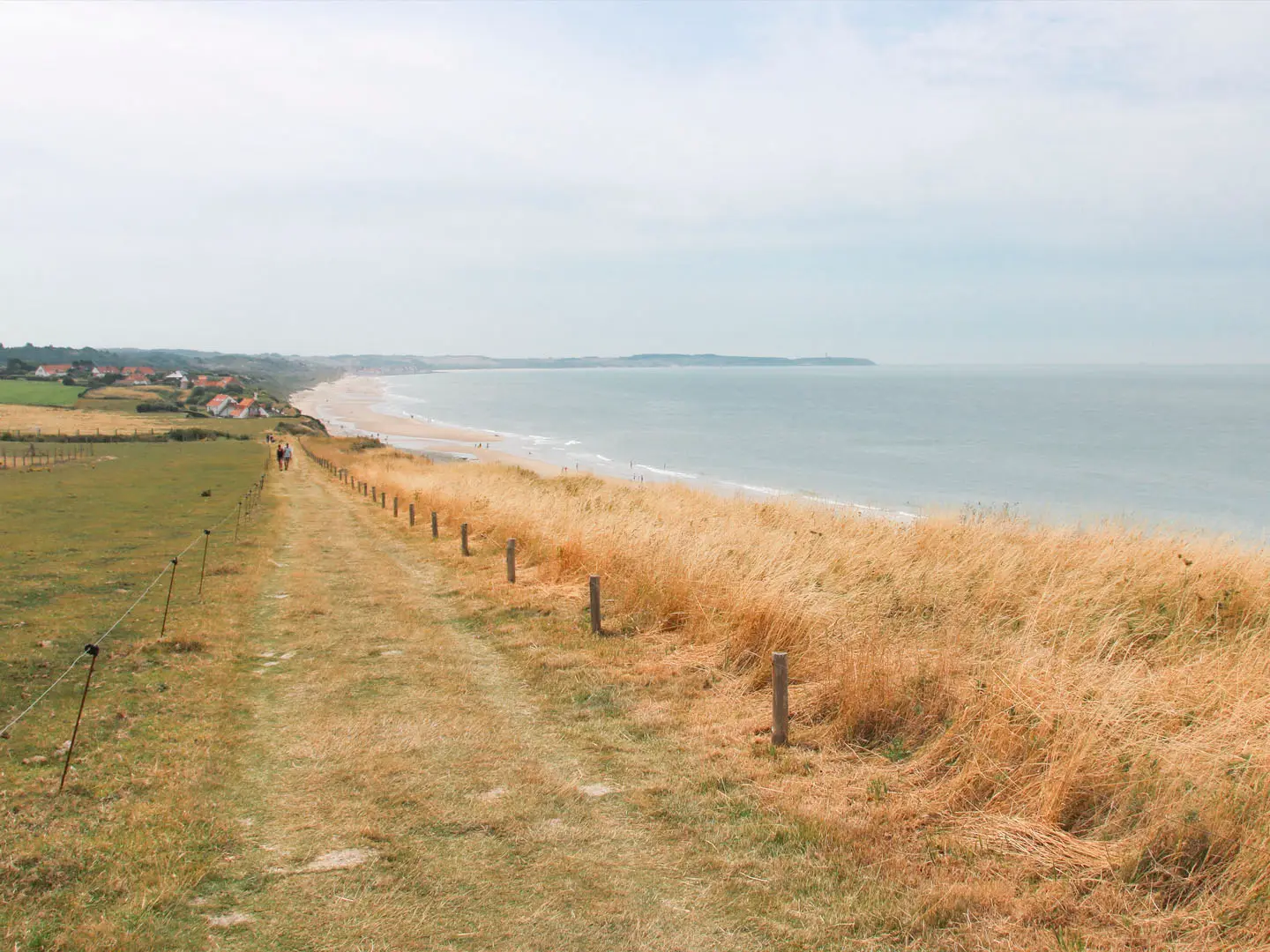
The GR120 – Sentier du Littoral is a 290 km waymarked coastal trail across Hauts-de-France, from Bray-Dunes on the Belgian border to Mers-les-Bains / Le Tréport. It is usually walked in 12 days and is moderate overall: the walking is mostly low-level and coastal, but the full distance, wind exposure, sand and occasional cliff climbs add up. This is a good long-distance route for hikers who want beaches, dunes, fishing ports and Channel history without alpine terrain. See more routes in France.
Route Overview
The GR120 is a point-to-point Grande Randonnée route, officially waymarked with red-and-white GR blazes and commonly walked north-to-south from Bray-Dunes towards the Baie de Somme. The route threads through Dunkerque, Gravelines, Calais, Cap Blanc-Nez, Wissant, Cap Gris-Nez, Boulogne-sur-Mer, Le Touquet / Étaples, Berck-sur-Mer, Saint-Valery-sur-Somme and Mers-les-Bains / Le Tréport. Rail access is excellent, with stations at Dunkerque, Calais, Boulogne-sur-Mer, Le Touquet-Étaples and others, so it works as a full thru-hike or in shorter sections. For more French coast and heritage walking, compare the D-Day Beaches Circuit, Bordeaux to Arcachon Trail and Canal du Midi Towpath.
Customs Paths, Wars and Channel Fortifications
Much of the GR120 follows old customs, or douaniers, routes once patrolled to deter smuggling along the Channel coast. This shoreline has long been strategically important opposite England: medieval conflict left walled towns and forts, including Vauban-era defences, while the Second World War left a heavy imprint. The Dunkirk evacuation of 1940 took place on this coast, and German Atlantic Wall bunkers and gun emplacements still appear among the dunes and cliffs.
Notable highlights
- Cap Blanc-Nez (134 m): The highest chalk cliff on the route, with wide views over the Strait of Dover and, in clear weather, towards England’s white cliffs.
- Cap Gris-Nez: The closest point of mainland France to Britain, where the Channel narrows to about 34 km. The CROSS Gris-Nez maritime traffic-control station monitors one of the world’s busiest shipping lanes.
- Grand Site des Deux Caps: The protected landscape between Cap Blanc-Nez and Cap Gris-Nez combines chalk cliffs, dunes and birdlife, and is one of the defining scenic sections of the GR120.
- Boulogne-sur-Mer: A major fishing port with a walled medieval old town, the Basilica of Notre-Dame and Nausicaá aquarium, making it one of the best resupply and overnight stops.
- Baie de Somme: A celebrated bay and birdwatching area, with harbour and grey seals often associated with its sandbanks.
- Belle-Époque resorts and fishing villages: Wimereux, Le Touquet, Berck, Mers-les-Bains, Wissant and Audresselles break up the coast with promenades, working harbours and places to stay.
Challenges to expect
Do not underestimate the GR120 because it is low-level. Long beach sections can be slow on soft sand, and exposed cliff-top paths and dunes are tiring in wind and rain. Winter is wet and windy, and small-town accommodation or services may close outside the main season. Navigation is helped by GR waymarks, but tides, promenades and urban sections around ports can make route-finding less straightforward.
HikeList Score
GR120 (Opal Coast Path) scored 90/100 on HikeList's trail-quality metrics.
See score breakdownHide breakdown
- Ideal length 91
- Balanced challenge 90
- Scenery & wildness 98
- Varied terrain 65
- Accommodation 100
- Food & support 88
- Path quality 87
- Season flexibility 89
Computed from length, challenge, scenery & wildness, terrain variety, accommodation, food & support, path quality and season flexibility.
 France
Show more data Show less
- Coastal
- Sand
- Dirt
- Grass
- Gravel
- Paved
- Hotels
- Guesthouses
- Campsites
- Hostels
- Family Friendly
- Pet Friendly
- Restrooms
- Water Sources
- Campsites
- Picnic Areas
Download Our Full Guide to GR120 (Opal Coast Path) FREE!
Get our comprehensive guide to this hike for free. Save it for later reading or print out at home.
In these collections
Photos from hikers
Taken on the trail by people who've reviewed GR120 (Opal Coast Path).
GR120 (Opal Coast Path): The Complete Guide
 i
Image by jef 77
i
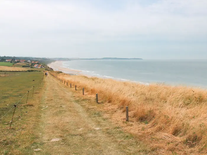
Image by jef 77 The GR120 is a long, low-level coastal walk along the Channel edge of northern France, running from Bray-Dunes on the Belgian border to Le Tréport and Mers-les-Bains at the Bresle estuary. Over roughly 290 km, it links dunes, beaches, ports, promenades, estuaries and the chalk headlands of the Côte d’Opale.
Its most memorable stretch is the Grand Site de France des Deux Caps, where the path crosses Cap Blanc-Nez and Cap Gris-Nez between Calais and Boulogne-sur-Mer. Here the route feels open and elemental, with grass clifftops, wartime remains, shipping lanes offshore and, in clear weather, views towards England.
Elsewhere the walk is more varied than a simple seaside trail. It passes through working ports such as Dunkerque and Boulogne-sur-Mer, resort towns including Wimereux and Le Touquet-Paris-Plage, and the wide bay landscapes of the Baie de Somme around Le Crotoy, Saint-Valery-sur-Somme and Cayeux-sur-Mer.
The walking is not mountainous, but it is not effortless. Soft sand, long exposed days, Channel wind, seasonal accommodation and tide-dependent beach sections mean this is best treated as a proper long-distance hike, not a casual promenade.
This guide covers stages, days, accommodation, food, transport, terrain and the common mistakes to avoid.
Stage-by-Stage Guide
The stages below use a practical 12-day schedule from Bray-Dunes to Le Tréport / Mers-les-Bains. Distances are approximate: the GR120 varies between beach, promenade and signed inland variants, and tide choices can change the walked line on the day.
Stage 1: Bray-Dunes to Dunkerque (Malo-les-Bains) — 18 km
The opening stage starts at Bray-Dunes on the Belgian border and heads south-west through the Flanders dune coast towards Dunkerque. Expect a low, open day of beach, dune paths and seafront walking through or near Zuydcoote, Leffrinckoucke and Malo-les-Bains.
Underfoot, this is a mixture of sand, dune tracks and promenade sections. Soft sand can make the day slower than the modest distance suggests, especially with a full pack or in strong wind.
The main interest is the scale of the northern beaches and dunes, with the history of the 1940 Dunkirk evacuation never far away. Views are broad rather than elevated: sea, sky, dunes and long straight beach horizons.
Food and water are easiest at the start and finish, with the best range in Dunkerque and Malo-les-Bains. Carry enough for the walking day if starting early, in winter, or outside the main holiday season when smaller seafront services may be closed.
Dunkerque and Malo-les-Bains offer the most straightforward overnight options for this stage. Dunkerque also has rail access, while Bray-Dunes has no working railway and is normally reached by DK'BUS from Dunkerque; current bus times should be checked before travelling.
Navigation is generally simple but the combination of dunes, promenades and beach alternatives means it is worth following the red-and-white GR blazes rather than simply walking the waterline. Check tide times before choosing beach sections, and expect exposure to Channel wind from the first day.
Stage 2: Dunkerque to Gravelines — 22 km
This is a more functional coastal stage, leaving the urban and port fringes of Dunkerque and continuing across the low northern coast towards Gravelines. It is not the most dramatic part of the GR120, but it is an important linking day between the Flanders dunes and the Calais coast.
Terrain is mostly flat, with a practical mix of seafront paving, tracks, dyke-like sections, town-edge walking and some road or port-side navigation. The walking is physically easy in gradient terms, but hard surfaces and wind exposure can be tiring.
Services are strongest in Dunkerque and at the end of the day in Gravelines. Do not assume frequent open cafés or shops between them outside the main season; start with enough water and food for a full stage.
Accommodation in Gravelines or nearby should be arranged before committing to the day’s end point, especially outside spring to early autumn. If accommodation is limited, the stage may need to be adapted around larger towns with better transport links.
Dunkerque is the key public transport point at the start of the day. Local onward transport from Gravelines should be checked before travelling, as the brief rail access for the GR120 is strongest at the larger coastal towns rather than every stage end.
Waymarking should be followed carefully around built-up and port-influenced areas, where the most attractive line is not always the signed GR route. There is little shelter on exposed coastal sections, so waterproofs and windproof layers should be kept accessible rather than packed deep in the rucksack.
Stage 3: Gravelines to Calais — 25 km
This stage continues the flat Channel coast through Petit-Fort-Philippe and Oye-Plage before reaching Calais. It is a longer day with a mixture of beach, dunes, low coastal tracks and the urban approach into one of the route’s major towns.
The terrain remains low-level, but the walking can still be slow where the route uses sand or exposed shoreline. Around towns and port infrastructure, expect more hard surfaces and occasional less-scenic connecting sections.
Petit-Fort-Philippe and Oye-Plage break up the day, but Calais is the main service and logistics hub. Carry water and lunch rather than relying on every smaller coastal settlement, particularly in shoulder season.
Calais has a wide choice of accommodation compared with the smaller places on the GR120. It is also one of the best transport points on the whole route, with Calais-Ville and Calais-Fréthun stations and ferry connections to Dover.
Navigation into Calais requires attention because busy urban and port sections can make the route feel less obvious than on open dunes. Stay with the GR waymarks and avoid improvising through restricted or operational port areas.
This is a practical day rather than a highlight stage. The main warnings are distance, exposure and the possibility of monotonous hard-surface walking near Calais, so good footwear and an early start are useful.
Stage 4: Calais to Wissant — 22 km
This is where the GR120 changes character, leaving Calais for the Côte d’Opale and the chalk-cliff country of the Grand Site de France des Deux Caps. The route passes the Sangatte / Blériot-Plage area, Escalles and Cap Blanc-Nez before descending towards Wissant.
The day includes the first real height of the trail, with Cap Blanc-Nez rising to 134 m and forming the walker-relevant high point of the route. The climb is modest by mountain standards, but the clifftop is exposed and can feel severe in strong wind.
Cap Blanc-Nez is one of the great viewpoints of the GR120, with the Dover Patrol Monument on the summit and, in clear conditions, views across the Strait of Dover to the white cliffs of England. The combination of chalk, open grassland and Channel shipping gives this stage a much more dramatic feel than the northern lowlands.
Food and water are straightforward at the start in Calais and usually possible in the coastal settlements, but Wissant is the key end-of-day stop. Wissant has limited beds compared with Calais or Boulogne-sur-Mer, and seasonal closures make advance booking important.
Calais is the main public transport hub for the start of the stage. Wissant is a village stop rather than a major railhead, so onward transport from there should be checked before travelling.
Tides matter on this section, especially if using any beach or foreshore line below the cliffs. Check the day’s tide times before setting out, leave a safety margin before high water, and do not get tempted onto a narrowing beach beneath cliffs.
Stage 5: Wissant to Wimereux — 23 km
This is the scenic heart of the GR120, crossing from Wissant over Cap Gris-Nez and continuing through Audresselles and Ambleteuse to Wimereux. It is one of the finest stages on the route, with chalk, dunes, grass clifftop, fishing villages and Channel views throughout.
Cap Gris-Nez is the closest point of mainland France to Britain, with the Channel narrowing to about 34 km. Its lighthouse and the CROSS Gris-Nez station sit above one of the world’s busiest shipping lanes, so the sea view is often as much about movement and navigation as landscape.
The stage also passes near the wartime remains of the Atlantic Wall around Audinghen, including the Todt Battery area, and through the protected Grand Site des Deux Caps landscape. Audresselles and Ambleteuse add a strong village character, with Fort Vauban d’Ambleteuse standing at the coast.
Terrain is varied: clifftop grass, dune paths, firm tracks, road or village sections and possible beach alternatives. Although the height gain is still modest, repeated short rises, wind and uneven ground make this a more demanding day than the profile suggests.
Food and water are available in the named villages and at Wimereux, but hours can be seasonal. Carry enough for the full day if walking outside the main holiday period, and do not depend on every small village having open supplies.
Wimereux is a well-served overnight stop just north of Boulogne-sur-Mer, with more accommodation choice than the smaller villages passed during the day. Public transport options improve again around Wimereux and Boulogne, but current local services should be checked before relying on them.
This is another tide-sensitive part of the walk. If the route choice involves beach or foreshore below the Deux Caps, tide times must be checked in advance; the safer default in uncertain conditions is to stay on the signed clifftop and inland GR line.
Stage 6: Wimereux to Boulogne-sur-Mer — 8 km
This short stage links Wimereux with Boulogne-sur-Mer and is useful as a half-day, rest-day stage or buffer after the Deux Caps. It gives time for laundry, resupply, transport connections or a visit to Boulogne without needing to compress the previous day.
The walking is mainly coastal and urban-edge, with more hard surfaces than remote trail. It is straightforward in distance and ascent, but still requires normal attention at road crossings and built-up sections.
Wimereux itself is a Belle-Époque seaside resort with a strong accommodation base. Boulogne-sur-Mer is a major stop on the GR120, known for its fishing port, walled upper town, Basilique Notre-Dame and Nausicaá.
Food, water and shops are easy to organise at both ends of the stage. This is one of the best places on the route for a full resupply before the longer sandy and resort-based stages to the south.
Boulogne-Ville has rail access and the town has a broad accommodation range. It is a logical place to start or end a section hike, or to build in a spare night if the weather has been poor.
Navigation is not difficult, but urban waymarking should not be treated casually. Follow the GR blazes through the town approach, as the direct-looking line on a map may not be the most practical walking route.
Stage 7: Boulogne-sur-Mer to Le Touquet-Paris-Plage — 28 km
This is one of the longer stages in the 12-day schedule, running south from Boulogne-sur-Mer through Le Portel, Équihen-Plage and Hardelot-Plage towards Le Touquet-Paris-Plage. It combines urban departure, open coast, dunes, resort edges and longer stretches where wind and sand can slow progress.
The terrain remains low, but the day’s length makes it a genuine effort. Expect a mix of hard surfaces leaving Boulogne, coastal tracks, dune paths, sandy sections and resort promenades or roads.
Le Portel and Équihen-Plage give the early part of the day a more local coastal feel, while Hardelot-Plage and Le Touquet-Paris-Plage bring the route into the line of interwar resorts, pine forest and long sandy beaches. Views are typically broad and open rather than elevated.
Food and water are best organised in Boulogne-sur-Mer before leaving. Hardelot-Plage and Le Touquet-Paris-Plage are the main service points later in the day, but opening hours can be seasonal, so a long-stage lunch and sufficient water should be carried.
Le Touquet-Paris-Plage has accommodation and transport options and is one of the route’s major resort stops. Rail access is available at or near Le Touquet-Paris-Plage, but exact station access and current train times should be checked before booking onward travel.
Navigation is mostly a matter of staying with the GR where the coast, resort roads and beach options overlap. This is a stage where tired walkers can be tempted onto long beach lines; check tide times and underfoot conditions before committing to sand late in the day.
Stage 8: Le Touquet-Paris-Plage to Berck-sur-Mer — 24 km
This stage heads from Le Touquet-Paris-Plage through the coast around Étaples, Stella-Plage and Merlimont to Berck-sur-Mer. It is a classic lowland coastal day of dunes, resort settlements, beaches and the wider estuary landscape around the Baie de la Canche.
The walking is physically moderate rather than steep, but beach and dune terrain can make progress uneven. Soft sand, repeated small dune rises and exposed wind are the main factors, not altitude.
Le Touquet-Paris-Plage and Berck-sur-Mer are both substantial resort stops, while Stella-Plage and Merlimont break up the route. The character is more open and sandy than the cliff stages north of Boulogne.
Food and water are available at the major start and end points and usually in the resort settlements en route, but seasonal closures remain a real planning issue. Carry a full day’s basics if walking outside summer or on a quiet weekday.
Berck-sur-Mer has accommodation and rail access at or near the town, making it a strong stage end and section point. Le Touquet-Paris-Plage also has rail access nearby, so this stage can be walked as a standalone section.
This is one of the key tide-planning stages on the GR120. The stretch between Le Touquet and Berck includes tide-dependent beach walking, so check tide times before setting out and keep a conservative margin before high water.
Stage 9: Berck-sur-Mer to Le Crotoy — 26 km
The route continues south from Berck-sur-Mer through Fort-Mahon-Plage and Quend-Plage before reaching Le Crotoy on the northern side of the Baie de Somme. It is a long, exposed stage dominated by dunes, beaches and big coastal skies.
Terrain is mostly flat but can be tiring underfoot. Long sandy sections, dune paths and resort approaches mean the stage may take longer than the distance alone suggests.
Fort-Mahon-Plage and Quend-Plage are useful intermediate settlements. The approach to Le Crotoy brings the GR120 into the Baie de Somme, one of the most important landscapes on the route, known for birds, seals and broad tidal sandbanks.
Food and water should be planned around Berck-sur-Mer, Fort-Mahon-Plage, Quend-Plage and Le Crotoy. In quieter months, do not rely on seasonal beachfront businesses; carry sufficient supplies from the start.
Le Crotoy is a recognised overnight stop with accommodation, though demand and seasonal patterns can affect availability. It also has rail access listed for the route, so it works well as a section end; current services should be checked before travelling.
Navigation is generally coastal but can be confusing where beach, dunes and resort access points create multiple tempting lines. Do not improvise across tidal sands around the Baie de Somme; stay on the waymarked route and check the tide before any beach walking.
Stage 10: Le Crotoy to Saint-Valery-sur-Somme — 16 km
This shorter stage follows the Baie de Somme from Le Crotoy to Saint-Valery-sur-Somme. After several longer beach days, it is a useful reduced-distance stage with time to enjoy the bay rather than simply cover ground.
The terrain is low and relatively easy, with estuary-side and coastal walking rather than cliffs or significant climbing. Wind exposure can still be strong because the bay is broad and open.
The Baie de Somme is one of the great highlights of the southern GR120. Its sandbanks, birdlife and seal habitat give the stage a very different feel from the Côte d’Opale cliffs and the resort beaches farther north.
Food and water are easiest at Le Crotoy and Saint-Valery-sur-Somme. Because the stage is shorter, there is less need to carry large quantities, but water and basic food should still be carried in case services are closed or the weather slows progress.
Saint-Valery-sur-Somme has accommodation and is one of the best-known stops around the bay. Rail access in the wider bay area includes Noyelles-sur-Mer and Le Crotoy; current connections should be checked before planning a section break.
The main navigation warning is not to treat the bay as open walking ground. Tidal estuary landscapes can be deceptive, so follow the GR line and avoid shortcuts over sands or mudflats.
Stage 11: Saint-Valery-sur-Somme to Ault — 27 km
This is a long southern stage from Saint-Valery-sur-Somme through Le Hourdel and Cayeux-sur-Mer to Ault. It leaves the inner Baie de Somme and moves towards the coast where cliffs begin to return near the end of the GR120.
The stage is low overall but exposed, with bay-edge walking, coastal sections, shingle or sand underfoot in places, and stretches where the wind can be relentless. The distance is the main challenge, especially after several consecutive coastal days.
Le Hourdel and Cayeux-sur-Mer are the key places passed between the start and Ault. Around the bay, the route remains close to one of France’s notable bird and seal areas; near Ault, the landscape begins to change towards the white-cliff finish.
Food and water should be organised at Saint-Valery-sur-Somme, with possible resupply in Le Hourdel and Cayeux-sur-Mer depending on opening hours. Because this is a 27 km day, start with enough to complete the stage if intermediate services are shut.
Accommodation at Ault should be booked in advance or checked carefully, as it is not one of the largest service centres on the route. If beds are tight, the final two stages may need to be adjusted around Cayeux-sur-Mer, Mers-les-Bains or Le Tréport.
There is no significant ascent to manage, but fatigue, wind and hard or uneven coastal surfaces can make the final kilometres feel slow. Stay alert around cliff-edge areas near Ault and do not use beach lines unless tide conditions are clearly safe.
Stage 12: Ault to Le Tréport / Mers-les-Bains — 9 km
The final stage is short but memorable, taking the GR120 from Ault through Bois-de-Cise to Mers-les-Bains and Le Tréport at the Bresle estuary. The chalk cliffs return for the finish, giving the route a strong closing contrast with the long beaches and bays to the north.
Terrain includes coastal and cliff-influenced walking rather than a demanding mountain profile. The distance is short, but wind exposure and cliff-edge awareness still matter.
Bois-de-Cise is the main named place between Ault and the finish. Mers-les-Bains is known for its colourful Belle-Époque seafront villas above the shingle, while Le Tréport sits just across the estuary at the foot of the cliffs.
Food and water needs are modest for a 9 km stage, but carry enough from Ault if starting early. Mers-les-Bains and Le Tréport provide the best end-of-route services, with accommodation available for those not travelling onward the same day.
The practical finish point can be described as Le Tréport / Mers-les-Bains: the FFRandonnée frames the route to Mers-les-Bains, while the railway station is Le Tréport–Mers-les-Bains. This makes the final stage straightforward for onward rail travel, but current train times should be checked before travelling.
Navigation is uncomplicated compared with the larger towns, but keep following the GR blazes to the actual finish rather than stopping at the first seafront. On cliff sections, stay on the path, keep clear of edges in strong wind, and avoid any unsafe foreshore options around high water.
Recommended Itinerary
Standard 12-day itinerary
This is a practical accommodation-led schedule for the full GR120 from Bray-Dunes to Le Tréport / Mers-les-Bains. Distances are approximate: beach, promenade and inland variants can change the day’s total, so check official mapping before booking fixed accommodation.
Several stages use tidal beaches or foreshore sections, especially around the Deux Caps and between Le Touquet-Paris-Plage and Berck-sur-Mer. Check tide times each evening and leave a safety margin before high water.
| Day | From | To | Approx. distance | Why this stage makes sense | Services/accommodation notes |
|---|---|---|---|---|---|
| 1 | Bray-Dunes | Dunkerque (Malo-les-Bains) | 18 km | A manageable opening day through the northern dune-and-beach section, finishing in a large, well-served coastal city rather than trying to push on through the port hinterland. | Bray-Dunes has no working railway, so most walkers reach the start by DK'BUS from Dunkerque. Dunkerque and Malo-les-Bains offer the strongest first-night services, accommodation and transport links. |
| 2 | Dunkerque | Gravelines | 22 km | A steady coastal day that keeps the itinerary moving without making the early stages too long. It suits walkers still adjusting to sand, wind and urban/industrial sections. | Dunkerque is a major service point. Gravelines is a sensible overnight stop before the approach to Calais. |
| 3 | Gravelines | Calais | 25 km | A longer but logical stage between two important coastal towns, setting up the scenic Deux Caps section that begins beyond Calais. | Calais has extensive accommodation and transport options, including Calais-Ville and access via Calais-Fréthun. It is one of the best places on the route to replace kit or adjust plans. |
| 4 | Calais | Wissant | 22 km | This stage leaves the urban coast and enters the chalk-cliff landscape around Cap Blanc-Nez, the route’s walker-relevant high point at 134 m. Ending in Wissant avoids rushing the Deux Caps section. | Wissant is a key overnight stop but smaller than Calais or Boulogne-sur-Mer, so book ahead, especially in the main walking season. Check tides before committing to any beach option below the cliffs. |
| 5 | Wissant | Wimereux | 23 km | One of the strongest scenic days on the GR120, crossing the Grand Site de France des Deux Caps via Cap Gris-Nez, then passing the smaller coastal settlements towards Wimereux. | Audresselles and Ambleteuse are useful intermediate places but have more limited beds than the larger resorts. Wimereux is a well-served overnight stop just north of Boulogne-sur-Mer. |
| 6 | Wimereux | Boulogne-sur-Mer | 8 km | A deliberately short day. It gives time for a slower start after the Deux Caps, for sightseeing or resupply in Boulogne-sur-Mer, and for preparing for the longer stage that follows. | Boulogne-sur-Mer is one of the route’s major service centres, with rail access at Boulogne-Ville and a wide choice of accommodation compared with smaller villages. |
| 7 | Boulogne-sur-Mer | Le Touquet-Paris-Plage | 28 km | A long coastal stage linking two major bases. It keeps the standard itinerary to 12 days while moving through the resort-and-dune coast south of Boulogne. | Start early, especially if walking conditions are slow underfoot. Le Touquet-Paris-Plage has broad accommodation and services; Étaples also sits on this section and has rail access nearby. |
| 8 | Le Touquet-Paris-Plage | Berck-sur-Mer | 24 km | A moderate-length stage through the sandy coast south of Le Touquet, where tide and beach conditions matter more than ascent. | Berck-sur-Mer is a larger coastal stop with accommodation and rail access nearby. Check tide times carefully for beach sections between Le Touquet-Paris-Plage and Berck-sur-Mer. |
| 9 | Berck-sur-Mer | Le Crotoy | 26 km | A substantial but sensible day that carries the route towards the Baie de Somme, with exposed coastal and bay walking. | Le Crotoy is one of the main settlements around the Baie de Somme and has rail access. Accommodation is seasonal, so booking ahead is prudent. |
| 10 | Le Crotoy | Saint-Valery-sur-Somme | 16 km | A shorter day around the Baie de Somme, useful after several longer stages and well suited to walkers who want time for the bay rather than simply covering distance. | Saint-Valery-sur-Somme is a strong overnight choice with visitor services and accommodation. This is also a sensible place to adjust the schedule if weather or tides have caused delays. |
| 11 | Saint-Valery-sur-Somme | Ault | 27 km | A long penultimate full day, continuing via the southern side of the Baie de Somme and the Cayeux-sur-Mer area before the cliffs begin to return near Ault. | Services thin out compared with the larger resorts, so carry food and water as needed and book the Ault overnight in advance. |
| 12 | Ault | Le Tréport / Mers-les-Bains | 9 km | A short final stage to the chalk-cliff finish at Mers-les-Bains and Le Tréport. It works well with onward travel from Le Tréport–Mers-les-Bains station. | Le Tréport–Mers-les-Bains is the practical rail endpoint. Mers-les-Bains and Le Tréport sit either side of the Bresle estuary, so check the exact finish and accommodation location before booking. |
Slower itinerary: 13–15 days
A slower schedule suits walkers carrying camping gear, those who want more time in the Deux Caps and Baie de Somme, or anyone walking outside peak fitness. It is also the safer choice if tides, strong wind or wet weather are likely to slow beach sections.
The easiest places to add time are:
- Calais to Wissant / Wissant to Wimereux: add a shorter day or extra night around the Deux Caps rather than rushing Cap Blanc-Nez and Cap Gris-Nez.
- Boulogne-sur-Mer to Le Touquet-Paris-Plage: split the long 28 km stage if suitable accommodation is available on the chosen line of walking. Check official mapping before booking.
- Le Touquet-Paris-Plage to Berck-sur-Mer: allow flexibility for tide-dependent beach walking.
- Saint-Valery-sur-Somme to Ault: split the 27 km stage if beds are available, especially when walking with a full pack.
Smaller places such as Wissant, Audresselles and Quend can have limited or seasonal accommodation. A slower itinerary should be built around actual available beds, not just map distances.
Faster itinerary: 9–10 days
A faster schedule is realistic only for strong coastal walkers comfortable with repeated 25–30 km days, soft sand and exposed wind. The low ascent makes high daily distances possible, but the route is not automatically quick: tidal timing and beach surfaces can make a nominally flat stage feel much harder.
The most obvious way to shorten the itinerary is to absorb the short Wimereux to Boulogne-sur-Mer day into an adjacent stage, or to combine the short final Ault to Le Tréport / Mers-les-Bains stage with the previous day. Both options create demanding days, so they suit fit walkers with light packs and pre-booked accommodation.
Avoid planning a fast itinerary that depends on crossing tide-sensitive sections at the wrong time of day. If the tide window is poor, it is better to keep the 12-day structure than to force a long beach stage into unsafe conditions.
Planning the Route
How many days to allow
Most walkers should plan the GR120 as a 12-day walk. That fits the FFRandonnée stage structure and keeps most days in the 15–32 km range, with overnight stops in the main coastal towns and resorts rather than in very small villages with limited beds.
Strong walkers can compress the route into 9–10 days by covering 25–30 km most days, but this is not always the most enjoyable way to walk it. The limiting factors are less about climbing and more about soft sand, exposed headwinds, tide timing and long built-up sections around ports and resorts.
A slower schedule of 13–15 days is sensible if you want shorter days through the Deux Caps, more time around Boulogne-sur-Mer or the Baie de Somme, or a rest day if the weather turns. This is also a better pace for walkers carrying camping gear, as sand and wind make flat mileage feel harder than it looks on a map.
Let accommodation shape the stages
The GR120 is best planned around overnight stops rather than equal daily distances. Good stage ends are the larger towns and resorts with transport, shops and a wider choice of beds: Dunkerque, Calais, Wimereux, Boulogne-sur-Mer, Le Touquet-Paris-Plage, Berck-sur-Mer, Saint-Valery-sur-Somme and Le Tréport / Mers-les-Bains.
Smaller places such as Wissant, Audresselles, Ambleteuse and Quend can make excellent stops, but accommodation is more limited and seasonal. Book these nights first, then adjust the walking days around them.
In spring-to-autumn holiday periods, coastal campsites, hotels and chambres d’hôtes can fill quickly. Outside the main season, the problem can be the opposite: many resort services and seasonal places close, so do not assume every named seaside village has an open bed or evening meal.
Fast, standard or slower itineraries
A practical way to choose a schedule is to decide how much sand and weather exposure you are willing to absorb each day.
| Schedule | Best for | Planning implications |
|---|---|---|
| 9–10 days | Fit walkers comfortable with repeated 25–30 km days | Fewer spare hours for tide delays, weather holds or sightseeing; accommodation must be booked tightly. |
| 12 days | Most independent long-distance walkers | Matches the natural rhythm of the route and keeps stage ends close to established towns and resorts. |
| 13–15 days | Campers, slower walkers, photographers, or anyone wanting buffer days | Easier tide planning and more time for the Deux Caps, Boulogne-sur-Mer and the Baie de Somme. |
The short Wimereux to Boulogne-sur-Mer and Ault to Le Tréport / Mers-les-Bains days are useful rather than inefficient. They give space to absorb a previous long day, deal with poor weather, visit town services or finish without rushing for onward transport.
Section hiking is straightforward
The GR120 is one of the easier French GR routes to split into sections because rail access is unusually good for a coastal trail. SNCF/TER stations at or near Dunkerque, Calais-Ville, Calais-Fréthun, Boulogne-Ville, Le Touquet-Paris-Plage, Berck, Noyelles-sur-Mer, Le Crotoy and Le Tréport–Mers-les-Bains make weekend and multi-day sections practical.
The start at Bray-Dunes needs a small transport link because it has no working railway. Reach it from Dunkerque by DK’BUS, around 15 minutes, then begin walking from the beach-and-dune coast near the Belgian border. Current bus and train times should be checked before travelling.
For a shorter high-scenery trip, the stretch from Calais or Sangatte / Blériot-Plage through Cap Blanc-Nez, Wissant, Cap Gris-Nez, Audresselles, Ambleteuse and Wimereux gives the classic Côte d’Opale experience. For birdlife, bays and a flatter estuary feel, the Le Crotoy, Saint-Valery-sur-Somme, Le Hourdel, Cayeux-sur-Mer and Ault section is the natural focus.
Tides are the key route-planning issue
Tide planning matters more on the GR120 than ascent, technical terrain or remoteness. Several beach and foreshore sections are tide-dependent, especially below the cliffs of the Deux Caps and between Le Touquet and Berck.
Check the day’s tide times before setting out and keep a safety margin before high water. Do not rely on being able to “push through” below cliffs or along narrowing beaches; if the tide is wrong, use the signed inland or promenade alternatives where available and accept the extra time.
Tides also affect pace. Firm low-tide sand can be quick; soft upper-beach sand can be slow and tiring, especially with a full pack or into a headwind.
Food, water and resupply
This is not a wilderness route, but food planning still needs attention. Long beaches, dunes and bay margins can feel remote between towns, and some seasonal resorts have limited opening hours outside peak months.
Plan each day with a known lunch or shop stop, rather than assuming every village has supplies. Carry enough water for exposed beach and dune sections, particularly when walking into wind or in warm weather, as shade can be limited.
The larger towns are the best places to restock fully: Dunkerque, Calais, Boulogne-sur-Mer, Le Touquet-Paris-Plage, Berck-sur-Mer, Saint-Valery-sur-Somme and Le Tréport / Mers-les-Bains. Smaller overnight stops should be treated as accommodation stops first and resupply points second unless opening times have been checked.
Navigation and maps
The route is waymarked with red-and-white GR blazes and is also part of the E9 European Coastal Path. It is widely referred to as the GR120, the Sentier du Littoral and, on parts of the coast, the sentier des douaniers; the Côte d’Opale is the famous central coastal section, not a separate trail to plan independently from the full route.
Waymarking is useful, but it should not be the only navigation tool. Carry the FFRandonnée topoguide or suitable IGN mapping, plus an offline GPX track on a phone or GPS device. Relevant IGN 1:25,000 sheets include Dunkerque, Gravelines / Audruicq, Calais / Site des Caps, Boulogne-sur-Mer, Le Touquet / Berck / Vallée de la Canche and Le Crotoy / Baie de Somme coverage.
Navigation attention is most useful in three situations: leaving and entering ports, choosing between beach and promenade variants, and checking safe lines around tide-dependent foreshore sections. In towns, the GR can feel less continuous than on rural paths, so do not assume every seafront promenade automatically equals the signed route.
Weather and exposure
The route is low-level, but it is exposed to Channel weather for much of its length. Wind can be the main daily difficulty, particularly on open beaches, dune crests, sea walls and clifftops.
Build flexibility into the schedule if possible. A hard headwind can make a flat 25 km day feel much longer, while rain and poor visibility reduce the value of the clifftop sections around Cap Blanc-Nez and Cap Gris-Nez.
Late spring to early autumn gives the best combination of daylight, open accommodation and manageable weather. Winter walking is possible in principle, but wet, grey, windy conditions and closed resort services make it a much less reliable time for an end-to-end walk.
Transport and start/end logistics
For an end-to-end hike, Dunkerque is the practical access town for Bray-Dunes, while Le Tréport–Mers-les-Bains station serves the southern finish. Calais, Boulogne-sur-Mer and the other rail-served resorts are useful bail-out or section points if weather, injury or accommodation problems force a change of plan.
From the UK, Dover–Calais ferries are operated by companies including P&O Ferries, DFDS and Irish Ferries, while Eurostar / Eurotunnel options connect via Calais or Lille. Boulogne-sur-Mer should not be planned as a ferry port.
Current train, bus, ferry and Eurostar arrangements should be checked before booking accommodation around them. Timetables and seasonal services can change, and missed connections can be awkward at the beginning or end of a long walking day.
Permits and local access
Permits are not the main planning issue on the GR120; accommodation, tides, transport and weather are far more important. Follow local signs in protected dunes, bays, cliff areas and resort seafronts, especially where paths are routed to protect fragile habitats or avoid unsafe foreshore.
Dogs, camping outside formal sites and access to sensitive coastal areas may be subject to local rules. This should be checked before travelling if it affects your plans.
Towns, Villages and Overnight Stops
The GR120 is easiest to plan as an accommodation-led coastal walk. The safest overnight stops are the larger ports and resorts — Dunkerque, Calais, Wimereux, Boulogne-sur-Mer, Le Touquet-Paris-Plage, Berck-sur-Mer, Saint-Valery-sur-Somme and Le Tréport / Mers-les-Bains — where beds, food and transport are most reliable.
Smaller places such as Wissant, Audresselles, Quend-Plage and some dune villages can work well, but accommodation is more limited and often seasonal. Outside the main spring-to-autumn walking season, book ahead rather than assuming campsites, cafés or chambres d’hôtes will be open.
Bray-Dunes
Bray-Dunes is the usual northern start of the GR120, close to the Belgian border. It is a practical first-night or pre-walk stop if you want to begin early on the beach and dune section rather than travel out from Dunkerque in the morning.
Accommodation and food options are those of a small seaside commune rather than a large town, so advance booking is sensible in peak season. There is no working railway at Bray-Dunes; reach the start by DK’BUS from Dunkerque, with the journey taking about 15 minutes. Current bus times should be checked before travelling.
Zuydcoote
Zuydcoote sits soon after Bray-Dunes on the Flanders dune section. It is more useful as a short break or emergency stop than as a primary stage end for most walkers.
Beds and services should be treated as limited compared with Dunkerque or Malo-les-Bains. If planning to stop here, book accommodation and check food options in advance, especially outside summer.
Leffrinckoucke
Leffrinckoucke lies between Zuydcoote and the Dunkerque seafront, still within the northern dune-and-beach approach. It can break up the first day if you are starting late or walking a very short opening stage.
Most walkers will continue to Malo-les-Bains or Dunkerque for a wider choice of beds, restaurants and onward transport. Treat Leffrinckoucke as a useful intermediate settlement rather than a dependable resupply hub unless arrangements have been made.
Malo-les-Bains
Malo-les-Bains is the beach resort district used in the typical first stage to Dunkerque. It is a strong overnight choice because it gives immediate access to the seafront while keeping you close to Dunkerque’s services.
Expect a better spread of accommodation, cafés and restaurants than in the smaller dune settlements to the east. It is also a good place to finish the first day if the weather has made the exposed beaches harder than expected.
Dunkerque
Dunkerque is one of the most useful logistics points on the whole route. It has broad accommodation and food options, rail access, and connections to Bray-Dunes for walkers starting or section-hiking the northern end.
The GR120 passes through a more urban and port-influenced landscape here, so it is a practical rather than secluded stop. It is a sensible place to arrive the night before starting, to resupply properly, or to split the first two stages.
Gravelines and Petit-Fort-Philippe
Gravelines is the natural overnight stop after Dunkerque on a standard 12-day schedule. Petit-Fort-Philippe is the coastal side of the same practical stop, useful for walkers wanting to stay closer to the beach.
This is a better bet for accommodation and meals than the more exposed stretches immediately before and after it. There is rail access at or near Gravelines, making it useful for section walkers linking the Flanders coast with Calais.
Oye-Plage
Oye-Plage lies between Gravelines and the Calais area. It is mainly an intermediate place for walkers rather than one of the principal overnight bases.
Use it for spacing, food or a shorter day only if accommodation and opening times have been arranged in advance. Otherwise, Gravelines and Calais are more dependable stage ends.
Calais
Calais is a major stage stop and one of the key access points for the GR120. It has a wide range of accommodation, food and transport, including Calais-Ville station and Calais-Fréthun for Eurostar and TGV connections.
For UK-based walkers, Calais is also the obvious entry point via the Dover–Calais ferries. It is a good place to reset logistics before the more scenic but more exposed Deux Caps section to Wissant and Wimereux.
Sangatte / Blériot-Plage
Sangatte and Blériot-Plage sit west of Calais on the approach to Cap Blanc-Nez. They are useful for shortening the Calais–Wissant day or for positioning close to the first clifftop section.
Accommodation and food options are more limited than in Calais, so they are best used with a booking rather than as a speculative stop. This is also where planning becomes more tide- and weather-conscious, as the route starts to feel less urban and more exposed.
Escalles
Escalles is the small settlement beneath Cap Blanc-Nez and is one of the most useful minor stops on the northern half of the trail. It suits walkers who want to avoid making Calais to Wissant a full day or who want to spend more time around the chalk cliffs.
Beds and meals should be booked ahead, particularly in busy periods around the Deux Caps. The main reason to stop is location: it puts you directly under the route’s highest chalk cliff and close to the Dover Patrol Monument area.
Cap Blanc-Nez
Cap Blanc-Nez is not a town, but it is an important route point between Calais and Wissant. It is the high point of the clifftop walking, not a practical overnight base.
Plan water, food and onward accommodation before reaching it. In poor visibility, strong wind or wet conditions, allow extra time for the exposed clifftop section and avoid relying on finding services at the cape itself.
Wissant
Wissant is one of the best small-resort overnight stops on the GR120 and a natural halt between Cap Blanc-Nez and Cap Gris-Nez. It works especially well in a 12-day itinerary, sitting between Calais and Wimereux.
Accommodation exists but is more limited and seasonal than in the larger ports, so book ahead. It is a good place for walkers who want a quieter stop in the heart of the Deux Caps rather than pushing on to Wimereux or Boulogne-sur-Mer.
Cap Gris-Nez and Audinghen
Cap Gris-Nez is a key scenic and navigation point rather than an overnight stop. Nearby Audinghen is the practical settlement associated with this part of the route, with the Maison du Site area and access to the Grand Site de France des Deux Caps.
Accommodation and food should not be assumed without booking. This section is exposed to Channel weather, and walkers should plan the day’s timing carefully, especially where beach or foreshore variants are affected by the tide.
Audresselles
Audresselles is a small fishing village south of Cap Gris-Nez and a rewarding but limited stop. It is useful for walkers wanting a shorter day between Wissant and Wimereux or a quieter night before reaching the busier resorts.
Beds are limited compared with Wimereux and Boulogne-sur-Mer, and seasonal closures matter. Book accommodation and evening meals in advance rather than arriving late and hoping for options.
Ambleteuse
Ambleteuse lies between Audresselles and Wimereux and is another possible short-stage stop. Its main local landmark is Fort Vauban d’Ambleteuse, but from a hiking point of view its value is as a small coastal base before the approach to Wimereux.
Services are more modest than in the larger towns. It can work well if you have accommodation arranged, but most thru-hikers will find Wimereux a more reliable overnight target.
Wimereux
Wimereux is one of the strongest overnight stops on the northern half of the route. It is a well-served resort just north of Boulogne-sur-Mer, with a better choice of accommodation and food than the small villages around the Deux Caps.
It is also a practical place to pause after the Wissant–Cap Gris-Nez–Audresselles section. Rail access is available at or near Wimereux, making it useful for section walkers and for anyone needing to shorten or restart the route.
Boulogne-sur-Mer
Boulogne-sur-Mer is a major logistical anchor on the GR120. It has plentiful accommodation, food, shops and rail access at Boulogne-Ville, and is the most useful full-service stop between Calais and the southern resorts.
Although the standard schedule gives only a short day from Wimereux, Boulogne is worth using for laundry, kit replacement, rest, or a late start after several exposed coastal stages. It is also the best place in this part of the route to recover from poor weather or adjust onward accommodation.
Le Portel
Le Portel sits immediately south of Boulogne-sur-Mer. It is generally more useful as part of the exit from Boulogne than as a necessary overnight stop.
If accommodation is unavailable in Boulogne or you want a shorter onward stage, it may be a workable alternative. Check beds and food before relying on it, as Boulogne remains the more dependable logistics base.
Équihen-Plage
Équihen-Plage is a coastal settlement between Boulogne-sur-Mer and Hardelot-Plage. It can help divide the long Boulogne to Le Touquet-Paris-Plage stage if you are not walking 25–30 km days.
Treat it as a planned stop rather than an improvised one. Accommodation and food availability should be checked before travelling, especially outside the main holiday season.
Hardelot-Plage
Hardelot-Plage is a useful resort stop on the long stretch south of Boulogne-sur-Mer. It sits in the coastal dune and pine-forest belt before the route continues towards Le Touquet-Paris-Plage.
It can be a sensible overnight choice for walkers who want to split the Boulogne to Le Touquet stage. As with many resort settlements on this coast, seasonal opening matters, so book ahead if walking outside summer.
Le Touquet-Paris-Plage
Le Touquet-Paris-Plage is one of the principal overnight towns on the southern half of the GR120. It has a strong accommodation and restaurant base and works well as a stage end after the long day south from Boulogne-sur-Mer.
Rail access is available at or near Le Touquet-Paris-Plage, making it a convenient point to start, stop or break the route. It is also the place to prepare carefully for the next section towards Berck-sur-Mer, where beach walking and tide timing can affect the day.
Étaples
Étaples sits by the Canche estuary and is closely linked logistically with the Le Touquet area. It can be useful if accommodation in Le Touquet-Paris-Plage is full or expensive, or if rail access is the priority.
For route planning, treat Étaples and Le Touquet as a paired stop area. Check the exact walking line and transport arrangements before booking, as where you sleep can affect the next morning’s start.
Stella-Plage
Stella-Plage lies between Le Touquet-Paris-Plage and Merlimont on the way to Berck-sur-Mer. It is mainly an intermediate resort stop for walkers wanting to shorten the Le Touquet to Berck stage.
Services are likely to be more seasonal than in the larger towns. If using Stella-Plage overnight, secure accommodation and food plans in advance rather than relying on late arrival.
Merlimont
Merlimont is another possible break point between Le Touquet-Paris-Plage and Berck-sur-Mer. It is useful for flexible stage planning, particularly if tide times make a direct beach-based day less convenient.
It is not as dependable a logistics hub as Le Touquet or Berck. Accommodation, shops and eating options should be checked before committing to it as a stage end.
Berck-sur-Mer
Berck-sur-Mer is a major resort stop and one of the most practical bases south of Le Touquet. It has a good concentration of accommodation and services and is a natural overnight halt before the long stage towards Le Crotoy.
Rail access is available at or near Berck, which makes it useful for section hiking. It is also a sensible place to review tide times and weather before continuing through the Authie and Somme coast sections.
Fort-Mahon-Plage
Fort-Mahon-Plage is a resort settlement between Berck-sur-Mer and Quend-Plage. It can break up the long Berck to Le Crotoy day, especially for walkers who prefer shorter stages or who are working around tide times.
Plan it as a booked stop rather than a guaranteed fallback. Seasonal accommodation and food opening should be checked before travelling.
Quend-Plage
Quend-Plage is a smaller coastal resort south of Fort-Mahon-Plage. It is useful for spacing the route before Le Crotoy, but accommodation is more limited than in the main towns.
Book ahead if using it as a stage end. For many walkers, it will be a daytime service stop or a way to reduce the length of the Berck to Le Crotoy section rather than an essential overnight.
Le Crotoy
Le Crotoy is a key overnight stop on the Baie de Somme. It has accommodation, food options and rail access, making it one of the most useful places to pause on the southern third of the route.
The standard itinerary uses Le Crotoy before the shorter stage to Saint-Valery-sur-Somme, which gives welcome flexibility after the longer Berck to Le Crotoy day. It is also a good point for section walkers using the rail-served Somme Bay towns.
Saint-Valery-sur-Somme
Saint-Valery-sur-Somme is one of the best overnight stops around the Baie de Somme. It has a strong visitor-service base and sits well for the onward stage towards Le Hourdel, Cayeux-sur-Mer and Ault.
Accommodation can be in demand during the main holiday season, so book early. It is a sensible place to resupply and check weather before the more open southern bay and coast section.
Le Hourdel
Le Hourdel is a smaller stop between Saint-Valery-sur-Somme and Cayeux-sur-Mer. Its main value for walkers is stage spacing around the Baie de Somme rather than broad services.
Do not rely on it as a major resupply point. If planning to sleep here, accommodation and meals should be arranged in advance.
Cayeux-sur-Mer
Cayeux-sur-Mer is a practical coastal stop before the route turns towards Ault and the return of the cliffs. It can be used to split the Saint-Valery-sur-Somme to Ault stage if 27 km is too long.
Services are those of a seaside town, but seasonal variation still matters. It is a useful alternative stage end for walkers who prefer steadier daily distances.
Ault
Ault is the standard penultimate overnight stop on the 12-day schedule. It sits before the short final stage to Mers-les-Bains and Le Tréport, where the chalk cliffs return at the end of the route.
Accommodation should be booked ahead because it is a smaller stop than Le Tréport / Mers-les-Bains. It is a good place to finish a longer day from Saint-Valery-sur-Somme and leave only a short final walk.
Bois-de-Cise
Bois-de-Cise lies between Ault and Mers-les-Bains on the final section. It is mainly a scenic intermediate point rather than a necessary overnight base.
For most hikers, the short Ault to Le Tréport / Mers-les-Bains stage means there is little need to stop here. If you do plan to stay, check accommodation and access before travelling.
Mers-les-Bains
Mers-les-Bains is one of the two usual southern finish points, standing opposite Le Tréport across the Bresle estuary. It is a practical end-of-walk base with resort accommodation and food options.
The railway station serving the finish is Le Tréport–Mers-les-Bains, located on the Le Tréport side. Mers-les-Bains is a good choice if you want to finish among the Belle-Époque seafront villas and stay close to the cliffs.
Le Tréport
Le Tréport is the other finish town and the most practical rail point at the southern end of the GR120. The Le Tréport–Mers-les-Bains station makes it the natural place for onward travel after completing the route.
Accommodation and restaurants are concentrated enough to make arrival straightforward in normal season, but booking remains sensible in busy periods. Some route descriptions finish at Mers-les-Bains and others at Le Tréport; for practical purposes, plan the finish around both towns and the shared station area.
Getting to the Start
The GR120 starts at Bray-Dunes, on the Belgian border just east of Dunkerque. The practical gateway is Dunkerque, because Bray-Dunes has no working railway station and the onward link to the trailhead is by local bus or taxi.
Some walkers also begin just over the border at La Panne / De Panne in Belgium, where the coastal path is also signed and walked. If doing this, check the exact start point and cross-border public transport before booking. This should be checked before travelling.
By train
Dunkerque is the nearest useful railhead for the start of the GR120. From Dunkerque, continue to Bray-Dunes by DK'BUS or taxi.
For walkers arriving from elsewhere on the route, SNCF/TER rail access is good along the coast, with stations at or near Dunkerque, Calais-Ville, Calais-Fréthun, Boulogne-Ville, Le Touquet-Paris-Plage, Berck, Noyelles-sur-Mer, Le Crotoy and Le Tréport–Mers-les-Bains. For the start, however, the key booking target is Dunkerque.
From the UK, rail-based approaches normally involve Eurostar or Eurotunnel services to Calais or Lille, then onward French rail to Dunkerque. Current connections, interchange stations and ticketing should be checked before travelling.
By bus
Bray-Dunes is reached from Dunkerque by DK'BUS. The journey is about 15 minutes, making it a straightforward final hop from the railway station area to the northern end of the trail.
Check the current DK'BUS timetable carefully, especially for early starts, Sundays, public holidays and out-of-season travel. This should be checked before travelling.
If the bus timing does not work, a taxi from Dunkerque is the simplest fallback. Pre-booking is sensible if arriving late, carrying camping gear, or starting outside the main holiday season; availability and fares should be checked before travelling.
By car
Driving to Bray-Dunes is possible, but it is not the cleanest option for a point-to-point walk ending at Le Tréport / Mers-les-Bains. Leaving a vehicle at the start creates a long return journey at the end of the hike, so most thru-hikers are better served by rail to Dunkerque and bus onward to Bray-Dunes.
If using a car for a section walk or a short break, check local parking rules in Bray-Dunes and Dunkerque before committing to an itinerary. Long-stay parking availability, seasonal restrictions and any charges should be checked before travelling.
From the nearest airport
No airport is needed for the standard approach to this trail: Dunkerque by rail, then DK'BUS to Bray-Dunes is the main access pattern. For international arrivals, the most practical airport will depend on your origin, onward rail connections and whether you are also using Eurostar, Eurotunnel or a Channel ferry.
From the UK, ferries run Dover–Calais with P&O Ferries, DFDS and Irish Ferries. Boulogne-sur-Mer is no longer a ferry port, so do not plan a ferry arrival there. Ferry times, foot-passenger arrangements and onward transport from Calais should be checked before travelling.
Where to stay before starting
Dunkerque is usually the most practical pre-walk base. It has rail access, onward DK'BUS links to Bray-Dunes, and more accommodation and food options than the smaller start area.
Staying in Bray-Dunes can make for an easier first morning, especially if aiming for an early beach start or if walking the signed extension from La Panne / De Panne. Availability can be seasonal on this coast, so book ahead and check opening dates outside the main spring-to-autumn walking season.
If arriving late by train, it is usually simpler to sleep in Dunkerque and take the bus or a taxi to Bray-Dunes the next morning rather than trying to complete the transfer after dark. Current bus times should be checked before travelling.
Getting Home from the Finish
By train
The finish is one of the easier places to leave the GR120 because Le Tréport–Mers-les-Bains station stands at the end of the route area, on the Le Tréport side of the Bresle estuary. If finishing in Mers-les-Bains, allow time to get across to the station rather than assuming the trail ends directly on the platform.
Use SNCF/TER for onward travel. Services and connections are timetable-dependent, so check current departures before fixing the final walking day, especially if planning to continue the same evening.
For section-walkers or anyone returning north along the coast, the wider GR120 is well supported by rail-served towns including Noyelles-sur-Mer, Berck, Le Touquet-Paris-Plage, Boulogne-sur-Mer, Calais-Ville and Dunkerque. Depending on the day’s timetable, journeys back to earlier trail towns may involve changes rather than a simple direct train.
If travelling back to the UK, the practical rail-and-sea gateways are farther north: Calais for Dover–Calais ferries, and Calais/Lille for Eurostar or Eurotunnel-related journeys. Boulogne-sur-Mer should not be planned as a ferry exit point, as Boulogne is no longer a ferry port.
By bus
Local bus options from the finish can be useful for short hops around Le Tréport, Mers-les-Bains and nearby accommodation, but they should not be assumed to run late or frequently. This should be checked before travelling.
If the final day ends after the last convenient train, a bus may not solve the problem. Build the final stage around the published train time, or plan to sleep at the finish and travel the following morning.
By car/taxi
A taxi is the simplest backup if finishing tired, in poor weather, or after a delayed final stage from Ault. It is also useful if accommodation is away from the station or on the Mers-les-Bains side and luggage, darkness or weather make the walk across town unattractive.
Do not rely on taxis being instantly available at the exact time the trail is finished. Pre-booking is sensible for evening arrivals, Sundays, public holidays and out-of-season trips. Current taxi availability should be checked before travelling.
For walkers who have left a car elsewhere on the route, the train is usually the more practical way to shuttle back to a rail-served trail town. Driving logistics are otherwise awkward because the GR120 is a long point-to-point route from Bray-Dunes to Le Tréport / Mers-les-Bains.
From the nearest airport
Flying is not the natural way to leave this route. The finish is best treated as a rail exit, with onward connections planned through the French rail network.
The most practical airport will depend on the final destination and available rail links on the date of travel. This should be checked before travelling rather than assuming a nearby airport will have useful flights or public transport connections.
Where to stay at the finish
Staying overnight at Le Tréport or Mers-les-Bains is often the most relaxed option, especially if completing the short final stage from Ault late in the day, waiting on a safe tide window, or connecting to long-distance travel the next morning.
Le Tréport is one of the route’s main accommodation centres, but coastal resort availability can still be seasonal. Book ahead in summer, at weekends and outside the main holiday season when some places may close or reduce services.
An overnight stop also gives a useful safety margin at the end of the hike. Channel weather, soft beach walking and tide-dependent sections earlier on the GR120 can all shift timings, so avoid booking a tight same-day train or international connection unless the final walking day is deliberately short and well buffered.
Which Direction Should You Walk?
The GR120 is normally planned north to south, from Bray-Dunes on the Belgian border to Le Tréport / Mers-les-Bains at the Bresle estuary. This is the direction used by the FFRandonnée framing of the route, and it fits the typical 12-stage itinerary from Bray-Dunes towards Mers-les-Bains.
Walking the route in reverse is perfectly possible, but it is less natural for most itineraries and gives a weaker finish unless your transport plans specifically favour starting at Le Tréport–Mers-les-Bains.
| Direction | Best for | Main drawbacks |
|---|---|---|
| Bray-Dunes → Le Tréport / Mers-les-Bains | Following the standard north-to-south route, using the common stage flow, finishing at the cliffs and railway station | Start requires reaching Bray-Dunes by DK'BUS from Dunkerque; check current times before travelling |
| Le Tréport / Mers-les-Bains → Bray-Dunes | Walkers who want to start directly from a rail-served town, or who have accommodation already fixed south to north | Ends at Bray-Dunes, which has no working railway; the final exit usually requires bus back to Dunkerque |
Transport logistics
For a full thru-hike, north to south is slightly neater overall. Bray-Dunes has no working railway, so the start involves reaching Dunkerque by train and taking DK'BUS to Bray-Dunes. This is a minor complication at the beginning rather than at the end.
Finishing at Le Tréport / Mers-les-Bains is more satisfying logistically because the Le Tréport–Mers-les-Bains railway station serves the twin resort area at the end of the walk. Train and bus times should still be checked before travelling, especially outside the main holiday season.
In reverse, the first step is simpler because you can start from Le Tréport–Mers-les-Bains station, but the final day leaves you at Bray-Dunes, where onward travel depends on getting back to Dunkerque by bus.
Scenery and route progression
North to south gives the best sense of progression. The walk begins with the Flanders beaches and dunes around Bray-Dunes, Zuydcoote, Leffrinckoucke and Dunkerque, then moves through Gravelines and Calais before reaching the route’s scenic centrepiece: Cap Blanc-Nez, Wissant and Cap Gris-Nez.
After the Deux Caps, the route continues through the ports and resorts of Wimereux, Boulogne-sur-Mer, Le Touquet-Paris-Plage and Berck-sur-Mer, then opens out around the Baie de Somme before the chalk cliffs return near Ault, Mers-les-Bains and Le Tréport. That makes the standard direction feel like a complete coastal journey, with a distinct cliff-and-resort finish.
Reverse walkers get an attractive opening at Le Tréport / Mers-les-Bains, but the final approach through the northern beaches towards Bray-Dunes is less obviously climactic.
Terrain, wind and tides
There is no meaningful climbing advantage in either direction. The GR120 is a low-level coastal route, with the only notable height around the chalk-cliff section over Cap Blanc-Nez and Cap Gris-Nez. The cumulative ascent is modest for a route of this length, so direction should not be chosen for easier climbs.
Wind can be a major factor on this coast, but it is too changeable to justify choosing a direction purely on that basis. Check the forecast before each stage and expect exposed walking on beaches, promenades, dunes and clifftops.
Tides matter more than direction. Several beach and foreshore sections are tide-dependent, especially around the Deux Caps and between Le Touquet-Paris-Plage and Berck-sur-Mer. Always check the day’s tide times and leave a safety margin before high water.
Accommodation flow
The standard north-to-south schedule works well with the main service towns: Dunkerque, Gravelines, Calais, Wissant, Wimereux, Boulogne-sur-Mer, Le Touquet-Paris-Plage, Berck-sur-Mer, Le Crotoy, Saint-Valery-sur-Somme, Ault and Le Tréport / Mers-les-Bains. It also gives a short final stage from Ault to Le Tréport / Mers-les-Bains, which is useful for catching onward transport.
Reverse direction does not create any fundamental accommodation problem, but it can make the last day less convenient because Bray-Dunes is a smaller end point and not rail-served. Smaller places such as Wissant, Audresselles and Quend have more limited beds, and many seasonal businesses close outside spring to autumn, so bookings matter whichever direction you choose.
Recommendation
Walk the GR120 from Bray-Dunes to Le Tréport / Mers-les-Bains unless there is a specific transport or accommodation reason to reverse it. This direction matches the usual route framing, gives the strongest scenery progression, keeps the awkward Bray-Dunes bus connection at the start, and ends with a clear psychological finish at the cliffs and railway-served twin resort.
Accommodation Along the Route
The GR120 is one of the easier French long-distance paths to plan as an inn-to-inn walk, because it passes a frequent chain of ports, seaside resorts and holiday villages. Accommodation is mixed: hotels, chambres d’hôtes, gîtes, youth hostels, campsites and holiday parks all occur along the coast, with the strongest choice in the larger towns.
The main planning issue is not the absence of accommodation overall, but the uneven spread of beds. Dunkerque, Calais, Wimereux, Boulogne-sur-Mer, Le Touquet-Paris-Plage, Berck-sur-Mer, Saint-Valery-sur-Somme and Le Tréport / Mers-les-Bains are the safest overnight bases. Smaller places such as Wissant, Audresselles and Quend have fewer options, and many coastal places are seasonal.
Booking strategy
Book ahead if walking in late spring, summer, early autumn, at weekends, or during French holiday periods. This matters most on the Côte d’Opale between Calais and Boulogne-sur-Mer, where Wissant and the Deux Caps section create natural stage breaks but the villages are small.
Outside the main season, do not assume that campsites, holiday parks, restaurants or small guesthouses will be open. Winter walking is possible in principle, but this coast is wet, windy and quiet, and the accommodation chain becomes less reliable. Opening dates should be checked before travelling.
For a 12-day itinerary, the standard overnight pattern works best if stage ends are built around the larger towns and the few strategic villages. Strong walkers can compress the route, but doing so may mean longer days across sand, dunes or exposed promenades rather than simply skipping from one well-served town to the next.
Best overnight stops and weaker points
| Place | Accommodation level | Best for | Notes |
|---|---|---|---|
| Bray-Dunes | Limited | Start night before setting off | Useful if starting at the Belgian border end of the route, but Dunkerque has more choice and is linked to Bray-Dunes by DK’BUS from Dunkerque. Times should be checked before travelling. |
| Dunkerque / Malo-les-Bains | Good | First major base; flexible start or restart point | One of the strongest accommodation and transport hubs on the northern part of the route. Good for walkers wanting to arrive the night before and begin from Bray-Dunes the next morning. |
| Gravelines / Petit-Fort-Philippe | Limited | Breaking the long flat northern coast | A practical stage end between Dunkerque and Calais, but with fewer options than the larger ports. Book rather than relying on turning up. |
| Calais / Sangatte / Blériot-Plage | Good | Major stop before the Deux Caps | Calais is a strong accommodation and transport base, especially for walkers arriving by ferry or rail. Sangatte and Blériot-Plage are useful for the coast path but have a smaller feel than central Calais. |
| Escalles / Cap Blanc-Nez area | Limited | Positioning for Cap Blanc-Nez | Useful for shortening the Calais to Wissant section, but the choice is limited. Do not plan this as a flexible last-minute stop. |
| Wissant | Limited | Strategic overnight between Cap Blanc-Nez and Cap Gris-Nez | One of the most important small stops on the GR120. Beds can be tight in season, yet the location is ideal for splitting the Deux Caps section. Book early. |
| Cap Gris-Nez / Audinghen | Limited | Visiting the Grand Site de France des Deux Caps | The cap itself is not a town-based overnight stop. Use Wissant, Audresselles, Ambleteuse or Wimereux depending on stage length and availability. |
| Audresselles / Ambleteuse | Limited | Shortening the Wissant to Wimereux stretch | Attractive coastal villages with limited beds. Useful if Wissant to Wimereux feels too long or if tides make timing awkward. |
| Wimereux | Good | Comfortable stop north of Boulogne-sur-Mer | One of the better-served resort stops on the Côte d’Opale and a natural overnight before or after Boulogne-sur-Mer. |
| Boulogne-sur-Mer | Good | Major resupply, rest and transport point | A key accommodation hub with the widest choice in this part of the route. Good for a rest night, laundry and resetting food plans. |
| Le Portel / Équihen-Plage / Hardelot-Plage | Limited | Breaking the long Boulogne to Le Touquet section | Useful coastal staging points south of Boulogne, but less dependable than Boulogne or Le Touquet for choice. Check availability before fixing a short-stage itinerary. |
| Le Touquet-Paris-Plage | Good | Resort stop with strong services | One of the safest overnight bases on the southern Côte d’Opale. Good for walkers who want a more comfortable hotel-based night. |
| Étaples | Limited | Alternative to Le Touquet area | Useful because it sits near the route and transport network, but plan accommodation in advance rather than assuming broad choice. |
| Berck-sur-Mer | Good | Main stop before the Authie and Somme coast | A strong resort base and a logical overnight before continuing towards Fort-Mahon-Plage, Quend-Plage and Le Crotoy. |
| Fort-Mahon-Plage / Quend-Plage | Limited | Breaking the Berck to Le Crotoy section | Quend is specifically a place where beds can be limited and seasonal. Campsites and holiday parks may help in season, but opening dates matter. |
| Le Crotoy | Limited | Northern side of the Baie de Somme | A useful overnight on the bay, especially before the shorter crossing-stage to Saint-Valery-sur-Somme. Book ahead in the main season. |
| Saint-Valery-sur-Somme | Good | Baie de Somme base; rest or resupply night | One of the best accommodation stops in the Somme section and a sensible place to pause before the longer stage towards Ault. |
| Le Hourdel / Cayeux-sur-Mer | Limited | Breaking the Saint-Valery to Ault stage | Useful if the longer Somme coast day needs shortening. Seasonal openings should be checked carefully. |
| Ault | Limited | Penultimate night before the short final stage | A practical stop before Mers-les-Bains and Le Tréport, but not a large accommodation hub. Reserve ahead if following the typical 12-day schedule. |
| Mers-les-Bains / Le Tréport | Good | Finish night and onward travel | The strongest end-of-route base, with Le Tréport–Mers-les-Bains station serving the finish area. Good for a final overnight before travelling home. |
Camping and holiday parks
Camping can work well on the GR120, particularly from late spring to early autumn, because the coast has a dense chain of campsites and holiday parks. These are concentrated around resorts and beach settlements rather than evenly spaced every few kilometres.
Check that each campsite accepts small backpacking tents, is open on the required date, and is close enough to the walking line to be practical after a full day. Some holiday parks are geared more towards static units and seasonal stays than one-night backpackers, so assumptions can cause problems.
Luggage transfers and taxi workarounds
This route is well suited to walkers carrying their own kit, because major towns recur regularly and rail access is strong. If walking light is essential, arrange baggage movement directly with accommodation providers or local taxis before committing to the itinerary. This should be checked before travelling.
Taxi transfers can also solve awkward accommodation gaps, especially where a small village is full but a larger town nearby has beds. The most sensible places to organise this are the larger hubs such as Dunkerque, Calais, Boulogne-sur-Mer, Le Touquet-Paris-Plage, Berck-sur-Mer, Saint-Valery-sur-Somme and Le Tréport / Mers-les-Bains.
Does it work as an inn-to-inn walk?
Yes. The GR120 is a good inn-to-inn route if accommodation is booked around the stronger towns and the limited villages are treated as fixed points rather than optional stops.
The key is to avoid planning too casually around Wissant, Audresselles, Quend, Ault and the smaller Baie de Somme settlements. These places are useful precisely because of their position on the route, but they do not offer the same depth of choice as the main ports and resorts.
Camping and Wild Camping
The GR120 can work well as a camping route if you use formal campsites and holiday parks rather than relying on wild camping. The coast has a relatively dense chain of seasonal campsites around the main resorts and ports, including areas such as Dunkerque, Calais, Wimereux, Boulogne-sur-Mer, Le Touquet-Paris-Plage, Berck-sur-Mer, Saint-Valery-sur-Somme and Le Tréport.
Do not assume every stage has an open campsite within easy walking distance of the GR. Many coastal sites operate seasonally, and smaller places such as Wissant, Audresselles and Quend can have limited accommodation at busy times or outside the main spring-to-autumn season. Book ahead where possible, especially in summer and at weekends.
Does the GR120 suit camping?
Yes, but it suits organised campsite camping better than lightweight “find a spot” backpacking. The route is low-level, well served by towns and resorts, and there are frequent opportunities to buy food, use cafés and refill water in settlements.
The disadvantages are exposure and lack of discreet legal camping ground. Long beach, dune and promenade sections leave little shelter from Channel wind and rain, while the more scenic areas often pass through protected dunes, clifftops, estuaries and popular resort fronts.
A camping kit should be wind-resistant and able to cope with sand. Pegging can be difficult on soft ground, and a tent pitched in exposed coastal weather will need more care than the route’s modest height profile suggests.
Best parts of the route for campsite-based hiking
The easiest camping logistics are generally around the larger resort and port stages, where services are concentrated and public transport gives backup options. These include the northern coast around Dunkerque and Calais, the Côte d’Opale resort belt around Wimereux and Boulogne-sur-Mer, the long resort section around Le Touquet-Paris-Plage and Berck-sur-Mer, and the Baie de Somme area around Le Crotoy, Saint-Valery-sur-Somme and Cayeux-sur-Mer.
The Grand Site de France des Deux Caps between Cap Blanc-Nez and Cap Gris-Nez is one of the most sensitive and exposed parts of the walk. Plan to use established accommodation or campsites in nearby settlements such as Wissant, Audresselles, Ambleteuse or Wimereux rather than improvising in dunes or on clifftops.
Wild camping and bivouacking
Wild camping should not be treated as a normal planning strategy on the GR120. The route crosses busy beaches, resort promenades, private land, working port areas, protected dunes, the Grand Site de France des Deux Caps and the Baie de Somme, which is an important bird and seal sanctuary.
Local rules can vary between communes, protected areas and land managers. If considering any form of overnight bivouac, ask locally and check the current regulations before relying on it. This should be checked before travelling.
Do not camp on beaches or tidal foreshore. Several GR120 sections are tide-dependent, especially around the Deux Caps and between Le Touquet-Paris-Plage and Berck-sur-Mer, and a safe-looking pitch can become dangerous as the tide rises or in poor weather.
Clifftops and dunes are also poor choices. They are exposed to wind, vulnerable to erosion and often part of managed natural areas where trampling damages fragile vegetation.
Water, food and facilities
Water is best managed through towns, campsites, cafés and accommodation. Do not rely on natural water sources along the coast; the route is dominated by beaches, dunes, estuaries and urban seafronts rather than dependable drinking-water streams.
Carry enough water for exposed beach and dune sections, particularly in warm weather or when a tide-dependent crossing forces a longer wait or diversion. Campsites should normally provide drinking water and washing facilities, but availability and opening dates should be checked before booking.
Food resupply is generally straightforward in the larger towns and resorts. Smaller villages and seasonal beach settlements may have fewer open shops outside the main holiday period, so buy before leaving larger stops when camping.
Fires, waste and low-impact camping
Open fires are inappropriate on this route. Dunes, dry grass, protected coastal habitats and busy resort areas make fires a poor and potentially dangerous choice, and campsite rules may also prohibit them.
Use a stove only where permitted, keep it stable in wind, and avoid cooking directly on fragile dune vegetation or dry grass. In strong coastal wind, a stove can become difficult to control.
Pack out all rubbish, including food scraps, and use toilets in campsites, towns and public facilities wherever available. The GR120 passes through heavily used beaches and sensitive nature areas, so low-impact behaviour matters more here than on remote upland routes.
Practical camping advice for the GR120
- Book formal campsites ahead in summer and confirm opening dates outside the main season.
- Build stages around known accommodation rather than assuming a campsite will appear at the right distance.
- Carry extra water through long dune, beach and clifftop sections.
- Check tide times before committing to beach variants or foreshore walking.
- Avoid dunes, clifftops, beaches, estuary margins and protected areas for any overnight stop.
- Expect wind: choose a tent that pitches securely and practise using it in exposed conditions.
- Keep a fallback plan using the railway-served towns if weather, tides or campsite availability disrupt the schedule.
Food, Water and Resupply
The GR120 is one of the easier French long-distance trails for resupply because it passes through frequent seaside resorts, ports and rail-served towns. Food planning is still worth taking seriously: many smaller coastal villages are seasonal, Sunday trading can be limited, and several stages include long exposed dune, beach or clifftop sections where there may be nowhere obvious to buy food or refill water.
Do not plan this route around wild water sources. The trail follows beaches, dunes, estuaries and urban seafronts; seawater and brackish estuary water are not useful for walkers, and filtering is not a practical primary water strategy. Treated water from accommodation, cafés, restaurants and shops is the dependable option.
How much to carry
For most stages, start the day with lunch, snacks and enough water to reach the next sizeable town even if cafés are shut. On a cool day with open services, this may be straightforward; on windy, sunny or warm days across sand and dunes, carry more than expected because the exposure is constant and shade can be limited.
As a practical baseline, most walkers should leave each overnight stop with at least a full day’s walking snacks and enough water for the whole stage. On longer stages such as Boulogne-sur-Mer to Le Touquet-Paris-Plage, Berck-sur-Mer to Le Crotoy, and Saint-Valery-sur-Somme to Ault, carry a proper packed lunch unless current opening hours have been checked in advance.
Where resupply is easiest
The best places to stock up are the larger towns and resorts: Dunkerque, Gravelines, Calais, Wimereux, Boulogne-sur-Mer, Le Touquet-Paris-Plage, Berck-sur-Mer, Le Crotoy, Saint-Valery-sur-Somme, Cayeux-sur-Mer, Mers-les-Bains and Le Tréport. These are the sensible points for buying picnic food, evening meals and emergency supplies before the more exposed coastal sections.
Smaller places such as Wissant, Audresselles, Ambleteuse, Fort-Mahon-Plage, Quend-Plage, Le Hourdel, Ault and Bois-de-Cise should be treated as useful but less reliable. They may have cafés, restaurants or small shops in season, but hours can be limited outside the main holiday period. This should be checked before travelling, especially for spring, autumn, Sundays and public holidays.
Section-by-section resupply
| Section | Food availability | Water availability | Notes |
|---|---|---|---|
| Bray-Dunes to Dunkerque / Malo-les-Bains | Generally good at the start and finish, with resort and urban services along the coast. | Refill before leaving Bray-Dunes and again in Dunkerque / Malo-les-Bains. | A short first stage, but do not rely on beach facilities being open outside the main season. |
| Dunkerque to Gravelines | Good at Dunkerque and Gravelines; more limited between built-up areas. | Carry enough from Dunkerque to reach Gravelines. | Expect urban and port-edge walking as well as open coastal sections. |
| Gravelines to Calais | Good at both ends; intermediate services should not be assumed. | Start with enough water for the full stage unless current stops have been identified. | A longer day, so carry lunch or buy it before leaving Gravelines. |
| Calais to Wissant via Sangatte / Blériot-Plage, Escalles and Cap Blanc-Nez | Good in Calais; more limited and seasonal once beyond the town. Wissant is the key resupply point at the end. | Fill up in Calais. Refill opportunities depend on open cafés or accommodation in the villages. | The Cap Blanc-Nez section is exposed and can feel longer in wind. Carry lunch and enough water before leaving Calais. |
| Wissant to Wimereux via Cap Gris-Nez, Audresselles and Ambleteuse | Wissant and Wimereux are the most reliable points; Audresselles and Ambleteuse can be useful but should not be relied on out of season. | Fill up in Wissant; refill only where businesses are open. | This is the scenic Deux Caps section, with clifftop and coastal exposure. Take enough food and water to walk through without a stop. |
| Wimereux to Boulogne-sur-Mer | Good at both ends. | Easy to manage with a normal day’s water. | This is a short stage, so resupply is rarely a problem. Boulogne-sur-Mer is one of the best places on the route to restock. |
| Boulogne-sur-Mer to Le Touquet-Paris-Plage via Le Portel, Équihen-Plage and Hardelot-Plage | Excellent in Boulogne-sur-Mer and Le Touquet-Paris-Plage; smaller resort services between them may be seasonal. | Leave Boulogne-sur-Mer with enough water for a long day. | One of the longer stages. Buy lunch before leaving Boulogne-sur-Mer unless current opening hours along the route are known. |
| Le Touquet-Paris-Plage to Berck-sur-Mer via Étaples, Stella-Plage and Merlimont | Good in Le Touquet-Paris-Plage, Étaples and Berck-sur-Mer; resort services between can vary by season. | Refill in Le Touquet-Paris-Plage or Étaples before committing to the coastal section. | Beach and dune walking can be slow and thirsty work. Check tide times as well as shop hours. |
| Berck-sur-Mer to Le Crotoy via Fort-Mahon-Plage and Quend-Plage | Good at Berck-sur-Mer and Le Crotoy; intermediate resort services may be seasonal. | Carry enough water from Berck-sur-Mer to reach a known open stop or Le Crotoy. | This is a long stage around dune and bay country. Carry a full lunch and do not assume every resort business is open outside summer. |
| Le Crotoy to Saint-Valery-sur-Somme | Good at both ends. | Straightforward if starting with a normal day’s supply. | A shorter Baie de Somme stage, but exposed weather can still increase water needs. |
| Saint-Valery-sur-Somme to Ault via Le Hourdel and Cayeux-sur-Mer | Good at Saint-Valery-sur-Somme and Cayeux-sur-Mer; more limited at Le Hourdel and Ault. | Fill up in Saint-Valery-sur-Somme and again in Cayeux-sur-Mer if possible. | A long stage. Carry lunch and enough water to continue even if smaller stops are closed. |
| Ault to Mers-les-Bains / Le Tréport via Bois-de-Cise | Food is available at the finish towns; Ault is smaller and should be checked for current opening times. | Carry enough from Ault to the finish. | A short final stage, but do not leave Ault without water, especially in warm weather. |
Seasonal and Sunday planning
The route is most straightforward from late spring to early autumn, when seaside cafés, restaurants, campsites and resort shops are more likely to be open. Outside the main season, smaller villages and beach resorts can be quiet, with reduced hours or full closures.
French coastal towns may also have limited Sunday and public-holiday shopping, and some smaller food shops close for part of the day. Buy the next day’s breakfast and lunch the evening before whenever a stage ends in a larger town, particularly before Wissant to Wimereux, Boulogne-sur-Mer to Le Touquet-Paris-Plage, Berck-sur-Mer to Le Crotoy, and Saint-Valery-sur-Somme to Ault.
Water strategy
Use accommodation taps as the main refill point at the start and end of each day, then top up from cafés, restaurants or shops where open. Public taps, beach facilities and seasonal kiosks may exist in some resorts, but they are not reliable enough to build a day’s plan around.
Natural water is not a sensible option on this trail. The GR120 stays close to the Channel, estuaries and sandy bays, so available water is often saline, brackish, contaminated by coastal use, or simply inaccessible. A filter can be carried as emergency kit if desired, but it should not replace carrying adequate treated water.
Terrain, Conditions and Difficulty in Practice
The GR120 is physically easier than most long-distance trails in France, but it is not effortless. The route is low, coastal and rarely steep, with about 1,217 m of cumulative ascent over the full walk and a walker-relevant high point of 134 m at Cap Blanc-Nez. The real difficulty comes from distance, wind, sand, tide timing and the stop-start nature of urban and port sections.
What you walk on
Underfoot, expect frequent changes rather than one consistent trail surface. The northern stages from Bray-Dunes through Dunkerque and towards Gravelines include broad beaches, dune paths, promenades and urban seafront walking. These sections can feel fast on firm sand or paving, then suddenly slow when the route crosses soft sand or loose dune paths.
Through the main towns and ports — including Dunkerque, Calais, Boulogne-sur-Mer and the larger resorts — the GR120 uses a mix of seafront paving, road, harbour-side walking and connecting streets. These miles are not technically difficult, but they can be tiring underfoot and less relaxing than open coast, especially with traffic, junctions and navigation through built-up areas.
The Deux Caps section between Calais, Wissant, Cap Blanc-Nez, Cap Gris-Nez and Wimereux is the most varied and exposed part of the route. Here the trail uses grass clifftop, dirt and gravel tracks, dunes and beach sections below or near the chalk cliffs. This is the scenic heart of the walk, but it is also where wind, cliff exposure and tide timing matter most.
South of Boulogne-sur-Mer the route returns to a flatter rhythm of dunes, beach, resort promenades, estuaries and bays, including the Baie de la Canche, Baie d’Authie and Baie de Somme. Around Le Touquet-Paris-Plage, Berck-sur-Mer, Le Crotoy, Saint-Valery-sur-Somme, Le Hourdel and Cayeux-sur-Mer, the walking is generally low-level but can be slowed by sand, long open stretches and weather exposure.
The final approach around Ault, Bois-de-Cise, Mers-les-Bains and Le Tréport brings the chalk cliffs back into the route. This is not a mountain finish, but it does add short climbs, descents and more exposed coastal walking after many days of mostly flat terrain.
Sand is the main underfoot challenge
Soft sand is the surface most likely to make a planned stage feel harder than its distance suggests. A 25 km day on firm promenades, dyke paths and compact beach can feel straightforward; the same distance with long soft-sand sections and a headwind can be draining.
On beach sections, the best walking is usually on firmer sand lower on the shore, but that depends on the tide and local conditions. When the firm line is unavailable, walkers may be pushed onto softer sand, dune paths or promenade alternatives where available. This is one reason distances on the GR120 should be treated as approximate rather than exact effort.
Footwear should be comfortable for mixed surfaces rather than built for rocky mountain ground. Lightweight walking shoes or trail shoes suit many walkers in dry conditions, but the choice still needs to handle wet sand, abrasive grit, paved resort sections and long daily mileage.
Tides are the key safety issue
Several GR120 beach and foreshore sections are tide-dependent, especially around the Deux Caps and between Le Touquet-Paris-Plage and Berck-sur-Mer. Tide times must be checked before setting out, with a margin before high water rather than relying on a close call.
A rising tide can remove the easy walking line and may force an unpleasant or unsafe retreat. Do not assume that a beach walked comfortably in the morning will be passable later the same day. If a stage depends on the foreshore, plan it around low water or use a safe inland, promenade or signed alternative where one is available.
Climbs, descents and exposure
There is almost no sustained climbing on the GR120. The total ascent is modest for a route of this length, and the high point at Cap Blanc-Nez is only 134 m. Most days are governed by horizontal distance rather than elevation gain.
The exception is the chalk-cliff and clifftop walking around the Deux Caps, plus the short cliff finish near Ault, Mers-les-Bains and Le Tréport. These sections bring more undulation, more exposure to wind and a greater need to pay attention to the edge, especially in poor visibility or strong gusts.
The route is not technically rocky and does not require scrambling. Difficulty comes from staying steady and sensible in exposed coastal conditions, not from hands-on terrain.
Wind, weather and seasonal conditions
The Channel coast is exposed, and wind is one of the defining conditions of the GR120. A headwind across open beach or clifftop can turn an otherwise easy stage into a slow day, while crosswinds on exposed sections can be tiring with a full pack.
Spring to early autumn gives the best combination of daylight, open services and generally more manageable conditions. Summer brings the easiest logistics in the resorts, but also busier promenades and beaches. Late spring and early autumn are often attractive for long-distance walking, provided accommodation and services are checked in advance.
Winter is possible for experienced coastal walkers, but it is a much harsher proposition: wet, grey, windy and with many resort services closed. Short daylight also reduces the margin for tide-dependent sections and long beach stages.
After rain, grass clifftop, dirt tracks and dune paths can be greasy or slow, though mud is not the defining problem of this trail. The more common irritants are wet sand, wind-blown sand, hard paving underfoot and the repeated transitions between beach, promenade and town streets.
Road walking, towns and navigation
The GR120 is waymarked with red-and-white GR blazes, but built-up areas still need attention. Through Dunkerque, Calais, Boulogne-sur-Mer, resort fronts and port approaches, the walking may involve roads, pavements, promenades and harbour infrastructure rather than a simple natural path.
These sections are useful for food, transport and accommodation, but they break the rhythm of the trail. Expect slower navigation through towns than on open beach, and allow time for crossings, diversions around port areas and finding the correct exit back to the coast.
Livestock, stiles and access furniture
Livestock fields, repeated stiles and complex fence crossings are not a defining feature of the GR120. The route is primarily beach, dune, promenade, dyke, clifftop grass, track and town walking rather than a field-to-field countryside path.
There may still be local barriers, gates, steps, beach access ramps or fenced dune/cliff protection areas. If step-free access or avoiding barriers is essential on a particular stage, this should be checked before travelling.
Why the route is rated moderate in practice
The terrain itself is often easy, and many individual kilometres are flat and straightforward. Over a full thru-hike, however, the GR120 becomes moderate because the effort accumulates: long days, soft sand, exposed wind, tide planning, urban walking and repeated changes of surface.
Fit walkers used to 20–30 km days should find the route very achievable with sensible stage planning. Walkers who are comfortable on hills but unused to sand may be surprised by how tiring the flatter sections can feel. The best preparation is not mountain fitness so much as being able to walk consecutive long days on mixed, hard and soft surfaces while carrying the kit needed for changeable coastal weather.
Weather and Best Time to Walk
The GR120 is best planned for late spring to early autumn, when daylight is longer, weather is generally more forgiving and the coastal accommodation chain is at its most reliable. This is a low-level route, so altitude is not the issue; the main weather challenges are Channel wind, rain, exposed beaches and clifftops, and tide timing.
Winter is possible for short sections from rail-served towns, but it is a poor season for a full through-hike. The coast is often wet, grey and very windy, days are short, and many resort services and smaller accommodation options close outside the main walking season.
Seasonal planning
| Season | What to expect | Practical advice |
|---|---|---|
| Spring | One of the better times to walk, especially later in the season. Cooler walking conditions suit the long beach and promenade stages. | Good for a full route attempt, but check accommodation carefully in smaller places such as Wissant, Audresselles and Quend, where seasonal opening can matter. |
| Summer | Longest daylight and the best chance of open services across the resorts and campsites. Exposed sand, promenade and dune sections can still feel hard in sun and wind. | Book ahead in resort towns and plan water and food stops before long beach or dune stretches. A hat, sun protection and windproof layer can all be needed on the same day. |
| Autumn | Often still a strong choice earlier in the season, with cooler conditions and fewer pressure points than high summer. Daylight reduces as the season progresses. | Keep stages realistic, especially the longer days between Boulogne-sur-Mer, Le Touquet-Paris-Plage, Berck-sur-Mer and the Baie de Somme. Check seasonal accommodation before relying on smaller stops. |
| Winter | Wet, grey, windy and with limited daylight. Resort services are reduced and some accommodation shuts. | Not recommended for a full end-to-end walk unless stages are kept short and based around larger towns with transport. This should be checked before travelling. |
Wind, rain and exposure
The route is almost entirely coastal, so wind has a bigger effect than the modest elevation profile suggests. A flat 25 km day can feel much harder when walking into a strong Channel headwind, particularly on open beaches, sea walls, dunes and the clifftops around Cap Blanc-Nez and Cap Gris-Nez.
Rain is less about technical difficulty and more about comfort, visibility and fatigue. Grass clifftop paths, dirt tracks and dune paths can become slippery or awkward after wet weather, while road and promenade sections remain straightforward but exposed.
A waterproof jacket is essential even in the main season, and a windproof layer is useful throughout the route. Lightweight footwear that copes with sand, wet paving and mixed tracks is usually more useful than heavy mountain boots, provided it is comfortable for repeated long days.
Heat, sun and soft sand
Summer heat is not the only concern: glare, reflected light from sand and long exposed promenades can be tiring even when temperatures are moderate. There is little shelter on many beach and dune sections, and wind can disguise sun exposure.
Soft sand is a year-round factor, but it is especially draining on longer stages if the tide or route choice keeps you away from firmer sand. Build extra time into days with substantial beach walking rather than judging them only by map distance.
Tides and weather windows
Several beach and foreshore sections are tide-dependent, especially below the cliffs of the Deux Caps and between Le Touquet-Paris-Plage and Berck-sur-Mer. Always check the day’s tide times before setting out and keep a safety margin before high water.
Poor weather makes tide decisions more serious. Strong wind, rain and reduced visibility can make it harder to judge progress on open beach sections, and escape options may be limited below cliffs or along long stretches of shore.
Daylight and stage length
The standard itinerary uses days of roughly 15–32 km, with some long coastal stages where the walking is physically repetitive rather than technically hard. In the better walking season, longer daylight gives more flexibility around tides, rest stops and slower sand walking.
Outside late spring to early autumn, short days make the longer stages more demanding. If walking in shoulder-season conditions, it is sensible to plan around the larger towns and rail-served stops such as Dunkerque, Calais, Boulogne-sur-Mer, Le Touquet-Paris-Plage, Berck-sur-Mer, Noyelles-sur-Mer, Le Crotoy and Le Tréport–Mers-les-Bains.
Accommodation and seasonal services
Weather planning and accommodation planning are closely linked on the GR120. Larger ports and resorts such as Dunkerque, Calais, Wimereux, Boulogne-sur-Mer, Le Touquet-Paris-Plage, Berck-sur-Mer, Saint-Valery-sur-Somme and Le Tréport have the most reliable range of beds and services.
Smaller villages and beach settlements have fewer options, and many seasonal places close outside spring-to-autumn. For a full through-hike, book ahead rather than assuming the next resort or campsite will be open, particularly in poor weather when pushing on is less appealing.
Safety Notes
Emergency help and communications
In France, dial 112 for emergency assistance. If arriving from the UK, do not rely on 999 once on the French side of the Channel; save 112 in your phone before starting.
The GR120 is not a wilderness route: it passes regular resorts, ports and rail-served towns such as Dunkerque, Calais, Boulogne-sur-Mer, Le Touquet-Paris-Plage, Berck-sur-Mer, Saint-Valery-sur-Somme and Le Tréport. Between these places, however, there are exposed dune, beach, bay and clifftop sections where shelter and immediate help may be limited.
Do not make mobile reception your only safety plan. Carry an offline map or GPX, know the name of the next town or access point, and keep enough battery for navigation and emergency calls.
Tides are the main safety issue
Several GR120 sections use or approach the foreshore, and some beach sections are tide-dependent. This is especially important below the cliffs of the Deux Caps and between Le Touquet-Paris-Plage and Berck-sur-Mer.
Check the day’s tide times before setting off, then build in a safety margin before high water. Do not start a beach section simply because the sand is passable at the access point; make sure there is a safe exit ahead before the tide turns.
If the timing is wrong, wait, use a promenade or signed inland option where available, or change the stage plan. Never allow a rising tide to trap you against cliffs, dunes, sea walls or harbour structures.
Weather exposure, wind and temperature
The route is low-level, but it is very exposed to Channel weather. Strong wind, rain, blown sand and poor visibility can make an otherwise easy coastal path tiring, especially on long open beaches and around the clifftops of Cap Blanc-Nez and Cap Gris-Nez.
Carry waterproofs and a warm layer even in the main walking season. In summer, long beach and promenade sections can also be hot and reflective, with limited shade, so carry enough water between towns and use sun protection.
Winter is generally a poor season for this route: the coast is wet, grey and very windy, daylight is short, and many resort services close. If walking outside spring to early autumn, check accommodation, food stops and transport especially carefully.
Cliffs, dunes and old coastal structures
The chalk-cliff sections around Cap Blanc-Nez, Cap Gris-Nez, and the final approach near Ault, Mers-les-Bains and Le Tréport need normal cliff-walking caution. Stay on the marked path, keep back from edges, and avoid walking directly below cliffs unless the tide and route line clearly make it safe.
Dune paths can be soft, shifting and more tiring than their distance suggests. Stay on established paths where they exist: this is safer, protects fragile ground, and reduces the risk of losing the way among informal tracks.
The coast also has Atlantic Wall remains, bunkers and old military structures, especially around the Deux Caps. Treat closed or informal structures as unsafe; only enter sites that are clearly open to visitors.
Road, town and port sections
The GR120 includes urban and port walking through places such as Dunkerque, Calais and Boulogne-sur-Mer, as well as seafront roads and resort promenades. Follow crossings, pavements and waymarks carefully, particularly in poor visibility, wind or rain.
Do not shortcut through restricted port or industrial areas. If a waymark is missed in a built-up area, stop and re-check the map rather than following the shoreline blindly into docks, private land or traffic-heavy streets.
Water, bays and estuaries
The route passes major coastal bays and estuaries including the Baie de la Canche, Baie d’Authie and Baie de Somme. Follow the marked route around these areas and do not improvise crossings over sandbanks, mudflats or channels.
Around the Baie de Somme, keep to accepted paths and viewpoints, and give wildlife such as seals plenty of space. Apart from being better for the animals, it avoids drawing walkers onto unsafe or restricted foreshore.
Solo walking and day-by-day checks
Solo walking is realistic on this well-served coastal trail, but the long distance and tide-dependent sections still require discipline. Tell someone your intended stage, expected finish and any planned beach sections, then check in at the end of the day.
Before setting off each morning, check:
- tide times and whether the day includes a beach or foreshore section;
- wind, rain, visibility and temperature;
- daylight available for the planned stage;
- the next reliable food, water and accommodation stop;
- rail or bus options if the stage needs to be shortened;
- whether seasonal services are open, especially outside spring-to-autumn;
- that offline maps, GPX or guidebook notes are available without mobile data.
Livestock is not a major hazard on this coastal route, but use standard care if the path crosses grazed grassland: keep gates as found, give animals space, and avoid getting between cattle and calves.
Gear Recommendations
The GR120 is not a mountain route, but it is hard on kit: salt air, wind-driven rain, sand, seafront paving and long exposed beach sections matter more than altitude. Pack for a low-level coastal trail where weather can change quickly and where several beach options depend on tide times.
Footwear
Lightweight walking shoes or trail shoes are usually the best choice for inn-to-inn hikers. The route mixes soft and firm sand, promenades, dune paths, grass clifftop, gravel tracks and town streets, so overly stiff mountain boots can feel heavy on long flat days.
Choose footwear with good grip for wet grass, chalky clifftop paths and compacted sand, plus enough cushioning for repeated hard surfaces through Dunkerque, Calais, Boulogne-sur-Mer and the resorts. If carrying camping gear, walking in colder months, or needing more ankle support, light boots are a sensible alternative.
Sand is unavoidable. Low gaiters can help keep grit out of shoes on beach and dune sections, especially between Bray-Dunes, the Flanders dunes, Le Touquet-Paris-Plage, Berck-sur-Mer and the Baie de Somme coast.
Waterproofs and wind protection
A proper waterproof jacket with a secure hood is essential, even in summer. The Channel coast is exposed for much of the route, and wind can make light rain feel much harsher than the modest elevation suggests.
Waterproof overtrousers are worth carrying for multi-day walkers, particularly in spring and autumn. A pack cover alone is not enough on this coast; use dry bags or a pack liner for spare clothing, sleeping kit and electronics.
A lightweight windproof layer is useful on dry but blustery days. On the clifftop sections around Cap Blanc-Nez and Cap Gris-Nez, and on open beaches and sea walls, wind chill can be more significant than the temperature reading suggests.
Warm layers
Carry at least one warm mid-layer, such as a fleece or synthetic insulated layer. Even though the high point is only Cap Blanc-Nez at 134 m, long exposed stages can feel cold when the wind comes off the Channel.
A warm hat or buff and light gloves are sensible outside high summer. They add little weight and are useful for early starts, ferry or rail transfers, and windy headlands.
Navigation and tide planning
The GR120 is waymarked with red-and-white GR blazes, but do not rely on paint alone. Carry offline mapping on a phone or GPS, and consider the FFRandonnée topoguide plus the relevant IGN 1:25,000 sheets for detailed navigation.
A power bank is strongly recommended. Phones are commonly used for maps, accommodation details, tide times and transport checks, and battery drain is faster in cold, wet or windy conditions.
Tide information is a safety item, not a convenience. Several beach and foreshore sections are tide-dependent, especially around the Deux Caps and between Le Touquet-Paris-Plage and Berck-sur-Mer. Check the day’s tide times before setting out and keep a margin before high water.
Water and food carry
The route passes many towns and resorts, but not every section has reliable all-day services. Smaller places such as Wissant, Audresselles, Quend and seasonal beach settlements can have limited opening outside the main spring-to-autumn period.
Most walkers should carry enough water for the full stage rather than assuming frequent refills. On longer 25–30 km days, and on hot exposed sand sections, increase capacity.
Carry lunch and high-energy snacks each day. This is especially important on stages that cross dunes, bays or quieter coast between larger service towns such as Boulogne-sur-Mer, Le Touquet-Paris-Plage, Berck-sur-Mer, Le Crotoy, Saint-Valery-sur-Somme and Ault.
Trekking poles
Trekking poles are optional but useful. They help with rhythm on long flat days, reduce strain on soft sand, and add stability in strong wind or on uneven dune and clifftop paths.
They are less necessary for short rail-based sections or fast day walks on promenades and town-linked stretches. If carrying them, use rubber tips on paved seafronts where appropriate.
Camping gear
Campers should use a tent that handles wind well, not just a fair-weather summer shelter. Coastal campsites and holiday parks are common along the route, but exposed pitches, sand and wet weather are realistic conditions.
Use secure pegs suitable for softer ground, plus a robust groundsheet or footprint if camping on sandy or gritty pitches. Keep sleeping kit in dry bags; salt air and wind-blown sand quickly work into zips, seams and electronics.
Many campsites and resort services are seasonal, particularly outside spring to autumn. Opening dates and booking requirements should be checked before travelling.
Sun, sand and insects
There is little shade on beaches, dunes, sea walls and clifftops. Sunglasses, sunscreen and a sun hat are important in summer, and still useful on bright spring or autumn days when reflected light off sand and water is strong.
A small tube of anti-chafe cream or foot balm is worthwhile. Long flat mileage, damp socks and sand in footwear are a common recipe for blisters.
Insect repellent can be useful in warmer months around dunes, estuaries and bays, including the Baie de Somme area. It is not usually a defining difficulty of the route, but it is light enough to justify carrying in season.
For inn-to-inn hikers
Keep the pack compact and weatherproof. A typical inn-to-inn setup should prioritise comfortable footwear, waterproofs, one warm layer, dry spare clothes, charging kit, tide information and enough food and water for the day.
Laundry and resupply are easiest in the larger towns and resorts, so there is little need to carry excessive spare clothing. Smaller overnight stops may have fewer services, especially outside peak season.
For campers
Campers need a more robust load plan because the flat profile can be misleading. Soft sand and long paved sections feel much harder with a heavy pack than the elevation profile suggests.
Prioritise a wind-stable tent, dry storage, a warm enough sleeping system for damp coastal nights, and a stove plan that does not depend on every small village having open shops. Seasonal campsite closures should be checked before building an itinerary around them.
For fast and section hikers
Fast hikers and rail-based section walkers can travel light, but should not strip out safety basics. A waterproof shell, warm layer, offline map, tide times, water, snacks and phone power are still essential.
The rail-served towns make short sections practical, but missed tide windows or worsening weather can still force a change of plan. Carry enough kit to wait, divert inland where necessary, or finish later than expected.
Budget and Costs
Budget for the GR120 in euros (€). The trail is not expensive because of permits or specialist access, but costs can rise quickly if every night is booked in seaside hotels, especially in resort towns and during the main spring-to-autumn walking season.
The biggest variable is accommodation. The route passes many well-served towns — including Dunkerque, Calais, Wimereux, Boulogne-sur-Mer, Le Touquet-Paris-Plage, Berck-sur-Mer, Saint-Valery-sur-Somme and Le Tréport / Mers-les-Bains — but smaller stops such as Wissant, Audresselles and Quend have fewer beds and more seasonal closures.
Budget styles
| Approach | Best fit | How costs are controlled | Main trade-offs |
|---|---|---|---|
| Budget | Campers, hostel users and flexible walkers | Use campsites and holiday parks where open, buy food from supermarkets and bakeries, use TER/SNCF trains and local buses rather than taxis | Seasonal campsite closures, fewer cheap beds in small villages, heavier pack if camping |
| Mid-range | Most independent hikers | Mix hotels, chambres d’hôtes, gîtes and the occasional campsite; eat simple restaurant meals in larger towns; use rail to join/leave sections | Accommodation must be booked ahead in smaller places and popular resorts |
| Comfortable | Walkers prioritising convenience | Stay mostly in hotels and guesthouses, eat out regularly, use taxis to shorten awkward stages or bypass poor-weather sections | Much higher cost in resorts such as Le Touquet-Paris-Plage, Wimereux and Saint-Valery-sur-Somme |
Accommodation
For a typical 12-stage walk, allow for roughly 11–12 nights, depending on whether travel days are added at Bray-Dunes, Dunkerque, Le Tréport or Mers-les-Bains. Faster walkers completing the route in 9–10 days save nights but have less flexibility if accommodation is full or if tides force a slower day.
Accommodation is mixed: hotels, chambres d’hôtes, gîtes, youth hostels, campsites and holiday parks. Campsites are the cheapest practical option where open, but many coastal places are seasonal, so never build a budget around camping without checking opening dates before travelling.
Hotel and guesthouse prices vary strongly by town, season and day of the week. Expect higher prices in the more popular resort stops, particularly Le Touquet-Paris-Plage, Wimereux, Berck-sur-Mer and the Baie de Somme area. Confirm current prices before booking.
Food and drink
Food costs are easy to control on this route because the GR120 regularly passes through towns, ports and resorts. The cheapest pattern is breakfast from a bakery or supermarket, a packed lunch, and a simple evening meal bought in town.
Eating out every evening will increase the budget significantly, especially in seaside resorts. Some smaller villages have limited food options outside the main season, so carry enough for lunch and do not assume there will be an open café at every stage end.
Transport to and from the trail
Rail access is one of the GR120’s budget advantages. SNCF/TER stations at or near Dunkerque, Calais-Ville, Calais-Fréthun, Boulogne-Ville, Le Touquet-Paris-Plage, Berck, Noyelles-sur-Mer, Le Crotoy and Le Tréport–Mers-les-Bains make it straightforward to section-hike or leave the route without relying on private transfers.
Bray-Dunes has no working railway. Most walkers reach the start by travelling to Dunkerque, then using DK’BUS to Bray-Dunes; the journey is about 15 minutes. Current bus and train times, and fares, should be checked before travelling.
From the UK, budget depends on whether you use Dover–Calais ferries, Eurostar, Eurotunnel connections or onward French rail. Boulogne-sur-Mer is not a ferry port, so do not plan around a ferry arrival there.
Taxis, luggage transfer and packages
Taxis are not essential for most walkers, but they are useful as a contingency if poor weather, tide timing or a full accommodation stop disrupts a stage. Budget extra if staying away from the trail in smaller villages or if shortening the longer days between Boulogne-sur-Mer, Le Touquet-Paris-Plage, Berck-sur-Mer, Le Crotoy and Saint-Valery-sur-Somme.
Do not assume a continuous luggage-transfer service exists along the whole route. If walking without carrying all gear, arrange baggage moves in advance through accommodation, local taxis or a walking-holiday operator, and confirm coverage for every stage before booking.
Self-guided packages may suit walkers who want accommodation arranged for them, but compare what is included: luggage transfer, maps or GPX, meals, tourist taxes and emergency support can make a large difference to the final cost. Confirm current prices before booking.
Cost-saving tips specific to the GR120
- Use rail-served stage ends where possible: Dunkerque, Calais, Boulogne-sur-Mer, Le Touquet-Paris-Plage, Berck, Noyelles-sur-Mer and Le Tréport–Mers-les-Bains are easier for arrivals, departures and section breaks.
- Book small villages early, especially Wissant, Audresselles and Quend, where limited beds can force an expensive taxi or a longer day.
- Avoid relying on last-minute resort hotels in the main walking season, particularly around Le Touquet-Paris-Plage, the Baie de Somme and popular weekend towns.
- Carry lunches between larger stops rather than depending on cafés along dune, beach and clifftop sections.
- Check tide times before setting out. A missed tide window can mean waiting, rerouting or paying for transport, particularly around the Deux Caps and between Le Touquet and Berck.
Luggage Transfer, Guided Tours and Support Services
Luggage transfer
The GR120 is a well-served coastal route, but it should not be treated as a trail with guaranteed end-to-end luggage transfer in the way that some major pilgrimage routes are. Dedicated baggage couriers may exist locally or seasonally, especially around the busier resort sections, but an organised full-route bag move from Bray-Dunes to Le Tréport / Mers-les-Bains should be arranged in advance rather than assumed. This should be checked before travelling.
For many walkers, the simplest approach is to carry a light pack and use the frequent towns and resorts for food, laundry and restocking. The route is low-level, but soft sand, wind exposure and long promenade or beach days make a heavy pack tiring over repeated 20–30 km stages.
If walking with luggage transfer, plan it around larger overnight stops such as Dunkerque, Calais, Wimereux, Boulogne-sur-Mer, Le Touquet-Paris-Plage, Berck-sur-Mer, Saint-Valery-sur-Somme and Le Tréport / Mers-les-Bains. Smaller places such as Wissant, Audresselles, Quend-Plage and Ault can have fewer services and more seasonal accommodation, so bag-drop arrangements need to be confirmed directly with the accommodation or local taxi.
When booking hotels, chambres d'hôtes or gîtes, ask specifically whether they can:
- accept luggage before check-in;
- store bags securely during the day;
- arrange a taxi transfer to the next overnight stop;
- receive bags from another accommodation or driver;
- handle luggage outside normal reception hours.
Do not rely on reception being staffed all day in smaller guesthouses. Give each property the date, approximate delivery time, number of bags, bag weight and the name on the booking.
Self-guided walking packages
A self-guided package is the most straightforward option for walkers who want accommodation booked, route notes supplied and luggage moved where possible. These trips usually suit hikers who want to enjoy the coast without spending time coordinating hotels, taxis and seasonal openings.
For the GR120, packages are most likely to focus on the best-known sections of the Côte d'Opale and the Deux Caps rather than necessarily covering the whole Bray-Dunes to Le Tréport / Mers-les-Bains route. A full-route itinerary may need to be custom-built, particularly if using the 12-stage schedule.
Before paying a deposit, check exactly what is included:
- whether the itinerary covers the full GR120 or only the Côte d'Opale section;
- daily distances and whether beach variants are used;
- luggage-transfer arrangements and any bag-weight limit;
- accommodation category and whether evening meals are included;
- what happens on tide-dependent sections;
- whether transfers are included at the start or finish;
- cancellation terms and seasonal availability.
Prices, dates and inclusions vary by operator and season, so current details should be confirmed when booking.
Guided walks and local support
A fully guided end-to-end GR120 is unnecessary for most competent walkers. The route is waymarked with red-and-white GR blazes, has regular towns, and is well suited to independent walking with the FFRandonnée topoguide, mapping and tide times.
Guided support can still be useful on short sections with strong natural, historical or safety interest, especially around the Grand Site de France des Deux Caps, Cap Blanc-Nez, Cap Gris-Nez and the Baie de Somme. These areas have sensitive dunes, cliffs, wartime remains, birdlife and seal habitats where local interpretation can add value and help keep walkers on appropriate paths.
If booking a guide, check whether the walk is a general nature or heritage outing, a section of the GR120, or a private transfer-supported walking day. Start time matters on this coast: walks using beach or foreshore sections must fit the tide, not just the group’s preferred schedule.
Taxis, rail bail-outs and section logistics
Local taxis are the most flexible support option for this trail. They are useful for shortening a long day, bypassing a closed or unsafe beach section, reaching accommodation away from the GR120, or moving luggage between nearby stage towns when no formal baggage service is available.
Pre-book taxis rather than relying on finding one at the end of the day, especially outside the larger towns and outside the main holiday season. Give the driver a precise pick-up point, as beach access points, promenades and dune car parks can be confusing.
The rail network makes the GR120 easier to section-hike than many long-distance trails. Useful rail-served points on or near the route include Dunkerque, Calais-Ville, Calais-Fréthun, Boulogne-Ville, Le Touquet-Paris-Plage, Berck, Noyelles-sur-Mer, Le Crotoy and Le Tréport–Mers-les-Bains. Bray-Dunes has no working railway, so the start is normally reached from Dunkerque by DK’BUS.
Train, bus and taxi times should be checked before travelling, particularly for Sundays, public holidays and off-season walking.
When support is worth paying for
Support services are most useful if you are walking the GR120 in a fixed holiday window, want to stay in booked accommodation every night, or prefer not to carry camping gear across long sandy sections. They are also helpful for mixed-ability groups, where a taxi or luggage transfer can keep daily mileage manageable.
Independent walkers on a budget can usually manage without formal support by carrying a light pack and using the larger towns for resupply. The key is to book accommodation early in smaller resorts, check tide times daily, and have rail or taxi options identified before committing to each stage.
Shorter Hikes and Best Sections
The GR120 is unusually easy to split for a coastal long-distance trail, especially around Dunkerque, Calais, Boulogne-sur-Mer, Le Touquet-Paris-Plage, Berck-sur-Mer, Le Crotoy and Le Tréport–Mers-les-Bains. The harder sections to arrange are the smaller villages around the Deux Caps, where Wissant, Audresselles and Ambleteuse are excellent walking stops but not as straightforward as the rail-served towns.
Several of the best short options use beach or foreshore sections. Check tide times before setting out, especially around the Deux Caps and between Le Touquet and Berck, and keep a margin before high water.
| Best for | Section | Approx. distance | Why choose it | Transport notes |
|---|---|---|---|---|
| Best day walk for scenery | Wissant to Wimereux | 23 km | Cap Gris-Nez, the Grand Site des Deux Caps, Audresselles, Ambleteuse and the approach to Wimereux in one full day | Wissant is best treated as a village stop rather than a railhead; local bus/taxi options should be checked before travelling. Boulogne-sur-Mer is the nearest major rail hub south of Wimereux. |
| Shorter beginner day | Ault to Le Tréport / Mers-les-Bains | 9 km | A compact finish on the return of the chalk cliffs, ending at the Bresle estuary and the Belle-Époque seafront of Mers-les-Bains | Le Tréport–Mers-les-Bains has a railway station. Access to Ault should be checked before travelling. |
| Best weekend section | Calais to Boulogne-sur-Mer | 53 km | The classic Côte d’Opale section: Cap Blanc-Nez, Wissant, Cap Gris-Nez, Audresselles, Ambleteuse and Wimereux, with a strong finish in Boulogne | Calais-Ville and Boulogne-Ville are railheads. Overnight stops are usually Wissant and/or Wimereux, but beds in Wissant can be limited and seasonal. |
| Best 3–5 day section | Calais to Le Touquet-Paris-Plage | 81 km | Combines the Deux Caps, Boulogne-sur-Mer, Hardelot-Plage and the resort-and-dune coast towards Le Touquet | Rail access at Calais-Ville, Boulogne-Ville and Le Touquet-Paris-Plage. This makes it one of the simplest multi-day sections to enter and leave. |
| Best for public transport | Boulogne-sur-Mer to Berck-sur-Mer | 52 km | A practical two-stage or three-stage section with large towns and resort services at either end | Rail access at or near Boulogne-Ville, Le Touquet-Paris-Plage and Berck. Check current TER times before booking accommodation. |
| Best for villages and accommodation choice | Calais to Boulogne-sur-Mer | 53 km | Gives access to Wissant, Audresselles, Ambleteuse, Wimereux and Boulogne, with more character than the larger resort-only sections | Book early in smaller villages, especially outside the main summer season when some places close. Calais and Boulogne are the most reliable transport anchors. |
| Best for camping and holiday parks | Le Touquet-Paris-Plage to Le Crotoy | 50 km | Resort-to-resort walking via Berck-sur-Mer, Fort-Mahon-Plage and Quend-Plage, with a dense chain of campsites and holiday parks in this part of the coast | Rail access at or near Le Touquet-Paris-Plage, Berck-sur-Mer and Le Crotoy. Campsites are seasonal; opening dates should be checked before travelling. |
Best day walk: Wissant to Wimereux
For a single big day on the GR120, Wissant to Wimereux gives the strongest mix of coastal scenery, villages and Channel history. The route crosses the Cap Gris-Nez area, passes Audresselles and Ambleteuse, and finishes at the elegant resort of Wimereux just north of Boulogne-sur-Mer.
At around 23 km, this is a proper day walk rather than a casual stroll. Start early, check the tide if using any beach or foreshore line, and avoid assuming that Wissant has the same transport flexibility as Calais or Boulogne.
Best short beginner option: Ault to Le Tréport / Mers-les-Bains
The final stage from Ault to Le Tréport / Mers-les-Bains is only about 9 km, making it the most manageable short sample of the trail. It still feels like a real finish, with the chalk cliffs returning before the route reaches Mers-les-Bains and Le Tréport at the Bresle estuary.
This is the better choice for walkers who want a shorter day without committing to soft-sand mileage or a long exposed stage. Le Tréport–Mers-les-Bains has a railway station, but access to Ault should be checked before travelling.
Best weekend section: Calais to Boulogne-sur-Mer
Calais to Boulogne-sur-Mer is the standout weekend or long-weekend version of the GR120. It is about 53 km in total, normally split via Wissant and Wimereux, with the option to make it two demanding days or three more comfortable ones.
This section contains the scenic heart of the route: Cap Blanc-Nez, the Dover Patrol Monument, Wissant, Cap Gris-Nez, Audresselles, Ambleteuse and Wimereux. Calais-Ville and Boulogne-Ville make the logistics much easier than a village-to-village itinerary.
Accommodation planning matters here. Wissant, Audresselles and Ambleteuse are smaller than the larger ports and resorts, and seasonal closures can reduce choice outside the main walking season.
Best 3–5 day section: Calais to Le Touquet-Paris-Plage
For a fuller short walking holiday, Calais to Le Touquet-Paris-Plage is the best-balanced option. At roughly 81 km, it fits neatly into four walking days using the typical stage pattern of Calais to Wissant, Wissant to Wimereux, Wimereux to Boulogne-sur-Mer, and Boulogne-sur-Mer to Le Touquet-Paris-Plage.
This section gives the most varied sample of the northern GR120: cliffs, dunes, fishing villages, Boulogne’s port and old town, then the resort coast towards Hardelot-Plage and Le Touquet. Rail access at Calais, Boulogne and Le Touquet makes it easier to shorten the plan if weather, tides or accommodation availability force a change.
Best section for public transport: Boulogne-sur-Mer to Berck-sur-Mer
Boulogne-sur-Mer to Berck-sur-Mer is about 52 km and works well for walkers who want rail-supported logistics rather than remote stage ends. The route can be split around Le Touquet-Paris-Plage, with rail access at or near Boulogne-Ville, Le Touquet-Paris-Plage and Berck.
This is not the wildest part of the GR120, but it is one of the easiest to organise independently. It suits a two-day fast walk or a three-day easier break using the larger resort towns for accommodation and food.
Best section for camping
Le Touquet-Paris-Plage to Le Crotoy is the most practical short section for walkers using campsites or holiday parks. The 50 km stretch passes through a run of resort areas including Berck-sur-Mer, Fort-Mahon-Plage and Quend-Plage before reaching Le Crotoy on the Baie de Somme.
This part of the coast has a strong seasonal camping infrastructure, but opening dates vary and many services are focused on spring to autumn. Check campsite availability before fixing daily distances, and pay particular attention to tides on the Le Touquet to Berck section.
Highlights and Points of Interest
The GR120 is at its most memorable where the coast changes character: the broad Flanders beaches in the north, the chalk headlands of the Deux Caps, the resort-and-port section around Boulogne-sur-Mer, then the dunes, estuaries and bird-rich bays of the southern coast. If time is limited, the strongest places to slow down are Wissant and the Deux Caps, Wimereux and Boulogne-sur-Mer, the Baie de Somme, and the final cliffs at Mers-les-Bains and Le Tréport.
Flanders dunes and Dunkerque
The opening section from Bray-Dunes through Zuydcoote, Leffrinckoucke, Malo-les-Bains and Dunkerque gives the trail its first big coastal scale: wide beaches, low dune belts and exposed Channel weather. This is also the coast associated with the 1940 Dunkirk evacuation, so the landscape has a strong wartime context as well as simple beach walking.
Dunkerque is one of the more practical places to pause early in the route, with transport and services that make it useful for anyone splitting the GR120 into sections. The beach-and-dune walking either side of the town can feel very different depending on wind, tide and sand conditions, so allow more time than the flat profile suggests.
Cap Blanc-Nez
Cap Blanc-Nez is the walker’s high point of the GR120 at 134 m and one of the clearest landmarks on the whole route. The chalk cliff is topped by the Dover Patrol Monument, an obelisk commemorating the First World War Dover Patrol.
In clear weather, this is the place for views across the Strait of Dover to the white cliffs of England. It is also the first major break from the long lowland beach-and-dune character of the northern stages, with grass clifftop walking and a more dramatic sense of height.
Wissant and the Grand Site de France des Deux Caps
Wissant sits between Cap Blanc-Nez and Cap Gris-Nez and is one of the best bases for spending extra time on the Côte d’Opale section. It gives access to both headlands and breaks up the most scenic part of the GR120 into manageable walking.
The protected Grand Site de France des Deux Caps is the scenic heart of the route, combining chalk cliffs, dunes and open grassland between the two capes. The Maison du Site visitor centre at Audinghen is the main named visitor stop for this landscape.
Some beach and foreshore options around the Deux Caps are tide-dependent. Check the day’s tide times before choosing any lower-level variant below the cliffs, and keep a margin before high water.
Cap Gris-Nez and the Channel shipping lanes
Cap Gris-Nez is the closest point of mainland France to Britain, with the Channel narrowing to about 34 km / 21 miles. Its 1958 lighthouse and the CROSS Gris-Nez station overlook one of the world’s busiest shipping lanes, making this a particularly good place to understand the geography of the Strait of Dover.
The cape also gives one of the route’s strongest combinations of natural and military interest. Around Audinghen and Cap Gris-Nez, remains of the Atlantic Wall, including German bunkers, gun emplacements and the Todt Battery, sit among the dunes and clifftops. The Todt Battery is now the Musée du Mur de l’Atlantique.
Audresselles and Ambleteuse
South of Cap Gris-Nez, Audresselles is a small traditional fishing village with low, colour-shuttered houses. It is one of the more characterful coastal settlements on the northern half of the route and a good contrast to the larger resort towns.
Ambleteuse is notable for the Fort Vauban d’Ambleteuse, a sea-girt fort built under Louis XIV. It is described as the last offshore fort between Cherbourg and Belgium and is one of the most distinctive historic structures directly on this stretch of coast.
Wimereux and Boulogne-sur-Mer
Wimereux is an elegant Belle-Époque seaside resort just north of Boulogne-sur-Mer, with seafront villas and good services. It is a sensible overnight stop and a useful place to pause before or after the Deux Caps section.
Boulogne-sur-Mer is one of the main cultural stops on the GR120. It is France’s leading fishing port and a Ville d’Art et d’Histoire, with a walled medieval upper town, the domed Basilique Notre-Dame and Nausicaá, one of Europe’s largest aquariums.
The short stage between Wimereux and Boulogne-sur-Mer makes it easier to build in extra time here without overloading a walking day. Boulogne is also a strong transport and resupply point for section hikers.
Hardelot and Le Touquet-Paris-Plage
Beyond Boulogne-sur-Mer, the route passes the resort coast around Hardelot-Plage and Le Touquet-Paris-Plage. This section is known for long sandy beaches, dunes and coastal pine forest, with a more polished resort feel than the fishing villages farther north.
Le Touquet-Paris-Plage is one of the more comfortable places to schedule a rest or shorter day, especially if accommodation and services matter more than solitude. Between Le Touquet and Berck-sur-Mer, some beach walking is tide-dependent, so tide times should be checked before setting out.
Baie de Somme
The Baie de Somme is the major natural highlight of the southern GR120. It is one of France’s celebrated bays and an important bird and seal sanctuary, with harbour and grey seals hauling out on its sandbanks.
The route links the bay settlements of Le Crotoy, Saint-Valery-sur-Somme, Le Hourdel and Cayeux-sur-Mer. This is one of the best areas to slow down if wildlife, open estuary landscapes and gentler coastal walking are a priority.
Ault, Bois-de-Cise, Mers-les-Bains and Le Tréport
After the long low sections of dunes and bays, the chalk cliffs return near Ault and Bois-de-Cise. This gives the final approach to Mers-les-Bains and Le Tréport a more dramatic finish than the flat middle and southern beach sections might suggest.
Mers-les-Bains is known for colourful Belle-Époque seafront villas above the shingle, while Le Tréport sits across the Bresle estuary. Together they make a satisfying endpoint, with the railway station at Le Tréport–Mers-les-Bains serving the finishing area.
Best places to allow extra time
| Area | Why pause here |
|---|---|
| Wissant and the Deux Caps | The strongest cliff scenery on the GR120, with access to Cap Blanc-Nez, Cap Gris-Nez and the Grand Site de France des Deux Caps. |
| Audinghen / Cap Gris-Nez | Channel views, shipping-lane geography, lighthouse setting and Atlantic Wall remains including the Todt Battery museum. |
| Wimereux and Boulogne-sur-Mer | Good services, Belle-Époque seafront architecture, Boulogne’s Ville Haute, Basilique Notre-Dame and Nausicaá. |
| Le Touquet-Paris-Plage | A comfortable resort stop with long beaches, dunes and coastal pine forest nearby. |
| Baie de Somme | Birdlife, seal sandbanks and a distinctive estuary landscape around Le Crotoy, Saint-Valery-sur-Somme, Le Hourdel and Cayeux-sur-Mer. |
| Mers-les-Bains and Le Tréport | Final white-cliff setting, colourful seafront villas and a practical rail-served finish. |
Common Mistakes and Planning Tips
Treating a flat coastal GR as an easy walk
The GR120 has very little ascent, but that is not the same as being effortless. Long days on soft sand, exposed promenades, dyke paths and windy clifftops can make a 22–28 km stage feel slower than the profile suggests.
Fix: plan around walking time, surface and weather rather than elevation gain alone. The 12-stage structure is a sensible baseline; only compress the route into 9–10 days if 25–30 km coastal days on sand and paving are comfortably within range.
Ignoring tide times
This is the biggest planning error on the GR120. Several beach and foreshore sections are tide-dependent, especially below the cliffs around the Deux Caps and between Le Touquet-Paris-Plage and Berck-sur-Mer.
Fix: check the day’s tide times before setting out and leave a safety margin before high water. Do not rely on yesterday’s timing, and do not commit to a beach line if the sea is already pushing up the shore; use the waymarked inland, promenade or dune route where that is the practical option.
Booking accommodation too late in smaller places
Beds are plentiful in the larger resorts and ports, but not evenly spread. Wissant, Audresselles, Quend and other smaller stops can have limited accommodation, and many seasonal places close outside the main spring-to-autumn walking period.
Fix: book the scarcer nights first, then build the rest of the itinerary around them. Dunkerque, Calais, Wimereux, Boulogne-sur-Mer, Le Touquet-Paris-Plage, Berck-sur-Mer, Saint-Valery-sur-Somme and Le Tréport / Mers-les-Bains give more flexibility than the smaller villages.
Assuming every village has food when needed
The route passes many settlements, but not every beach village or resort edge has a useful shop open at the moment a walker arrives. Seasonal opening, lunch closures and Sunday trading can catch out hikers who carry no margin.
Fix: buy lunch and water in the larger towns before committing to dune, beach or bay sections. Restaurant, supermarket and campsite opening times should be checked before travelling, especially outside high season.
Planning stages only from map distance
A stage that looks short on paper may include soft sand, headwind, urban navigation through ports, or slower clifftop paths. Conversely, the short Wimereux to Boulogne-sur-Mer stage can be useful as a recovery day, resupply day or buffer.
Fix: keep at least one flexible or shorter day in the schedule. Avoid making every day a maximum-distance day, particularly through the exposed Côte d’Opale and the long southern beach-and-bay sections.
Relying only on red-and-white waymarks
The GR120 is waymarked, but waymarks alone are not enough for a multi-day coastal route. Urban sections around ports, promenades, dune paths and beach alternatives can make the line less obvious, and coastal routes may change where erosion, access or local works affect the path.
Fix: carry an offline map or current GPX as well as following the GR blazes. The FFRandonnée topoguide and appropriate IGN 1:25,000 mapping are the best planning references for stage ends, accommodation and local variants.
Using an exact distance as if it were fixed
Published distances for the full GR120 vary, partly because of different start points, beach-versus-promenade choices and the Bray-Dunes / Belgian border variation. The practical walking distance sits around the high-200 km range rather than one perfectly fixed figure.
Fix: do not book return transport on the assumption that every measured kilometre will match a single GPX file. Allow time for local diversions, tide choices, weather delays and route variants.
Misunderstanding the route names
The GR120 is also called the Sentier du Littoral and is part of the E9 European Coastal Path. The Côte d’Opale is the famous central coastal section, especially around Cap Blanc-Nez and Cap Gris-Nez, but it is not the whole trail.
Fix: when booking accommodation or checking maps, search using the actual place-to-place line: Bray-Dunes to Le Tréport / Mers-les-Bains. Do not accidentally plan only the Calais-to-Boulogne-sur-Mer scenic centre if the intention is to walk the full GR120.
Forgetting that Bray-Dunes has no working railway station
The northern trailhead is straightforward to reach, but not by train all the way to the start. Bray-Dunes is reached from Dunkerque, with DK’BUS providing the local connection.
Fix: build the Dunkerque-to-Bray-Dunes transfer into the first day rather than treating Bray-Dunes like a railhead. Current DK’BUS and TER/SNCF times should be checked before travelling.
Assuming the finish is awkward to leave
The route finishes around Le Tréport / Mers-les-Bains at the Bresle estuary, where the railway station is Le Tréport–Mers-les-Bains. This makes the end more practical than many coastal point-to-point walks, but services still need checking.
Fix: plan the final overnight and onward train around Le Tréport–Mers-les-Bains station. If walking the short final stage from Ault, avoid booking an onward connection so tight that wind, weather or cliff-path conditions leave no margin.
Planning UK access via Boulogne ferry
Boulogne-sur-Mer is an important stop on the route, but it is no longer a ferry port for cross-Channel travel. Planning a UK arrival or departure around a Boulogne ferry will fail.
Fix: use Dover–Calais ferries, Eurostar / Eurotunnel routes via Calais or Lille, or the TER/SNCF network to connect with the trail. Check current ferry, Eurostar and train options before booking.
Underestimating Channel weather
This coast is exposed for much of the route, with little shelter on beaches, dunes, promenades and clifftops. A headwind can change the difficulty of a day more than the elevation profile does.
Fix: pack for wind and wet weather even in the main walking season. Keep warmer layers accessible, protect maps and electronics from spray and rain, and be ready to shorten or adjust a stage if the forecast turns poor.
Leaving no buffer for seasonal logistics
Winter and the edges of the season bring shorter daylight, stronger weather exposure and more closed services. Even in spring and autumn, resort businesses may not keep the same hours as in summer.
Fix: late spring to early autumn is the simplest planning window. Outside that period, confirm accommodation, campsites, food stops and transport before relying on them, and carry enough food to bridge a missed shop or closed restaurant.
Final Advice
The GR120 suits walkers who like long coastal days, regular towns and flexible logistics more than remote wilderness. It is physically approachable because the climbing is minimal, but it should still be treated as a proper long-distance hike: wind, soft sand, exposed promenades, port approaches and repeated 20 km-plus days can make progress slower than the elevation profile suggests.
The single most important planning task is tide timing. Several beach and foreshore sections, especially around the Deux Caps and between Le Touquet-Paris-Plage and Berck-sur-Mer, need to be walked with the day’s tide times in mind and with a safety margin before high water. If conditions or timing are wrong, use the safer inland or promenade alternative where available rather than forcing a beach line.
Accommodation is the other key constraint. Larger stops such as Dunkerque, Calais, Boulogne-sur-Mer, Le Touquet-Paris-Plage, Berck-sur-Mer, Saint-Valery-sur-Somme and Le Tréport / Mers-les-Bains give the most reliable choice, while smaller places such as Wissant, Audresselles and Quend can be limited and seasonal. Book ahead in busy periods and check opening dates outside the main spring-to-autumn season.
The most rewarding walking is the central Côte d’Opale section through the Grand Site de France des Deux Caps, crossing Cap Blanc-Nez, Wissant and Cap Gris-Nez before continuing towards Audresselles, Ambleteuse and Wimereux. This is the part to prioritise if time is short: it has the strongest mix of cliffs, dunes, Channel views and coastal history.
As a full thru-hike, the route works well for fit walkers who want a continuous Belgian-border-to-Bresle-estuary journey with good rail access at both ends and several exit points along the way. It is equally strong as a section hike, because stations at or near Dunkerque, Calais, Boulogne-sur-Mer, Le Touquet-Paris-Plage, Berck, Noyelles-sur-Mer, Le Crotoy and Le Tréport–Mers-les-Bains make weekend or multi-day blocks straightforward to organise.
For most hikers, the best strategy is to keep the pack light, plan stages around services rather than arbitrary mileage, and allow the coast to dictate the day when wind or tides are unfavourable. Carry current mapping or GPX alongside the red-and-white GR waymarks, check transport and accommodation before travelling, and do not underestimate how tiring a flat coastal trail can become after several consecutive days in Channel weather.
Useful Links
Hand-picked external resources for planning and researching the GR120 (Opal Coast Path) — official trail sites, maps and GPX downloads, baggage transfer and local information. Each link opens in a new tab.
Official & reference
-
 GR120 (Sentier du Littoral) – Wikipedia (French) fr.wikipedia.org
The encyclopedic overview of the GR120 coastal path from the Belgian border to Le Tréport, with the route, the departments it crosses, accessible rail stations, nature reserves and its place in the European E9 network.
-
 FFRandonnée – Itinérance sur le GR120 Côte d'Opale ffrandonnee.fr
The French Hiking Federation's own page on the GR120, covering the 12 stages from Bray-Dunes to Mers-les-Bains and pointing to the official topoguide that lists every accommodation and resupply stop.
Maps & GPX
-
 GR-Infos – GR120 Sentier du Littoral gr-infos.com
An English-language planning page for the full Bray-Dunes to Le Tréport route with an IGN topographic map, the relevant IGN map sheets and a downloadable GPX track.
-
 Baie de Somme Tourism – GR120 from Bray-Dunes to Le Tréport tourisme-baiedesomme.fr
Official tourist-office page for the whole GR120 with downloadable GPX and KML files, a route description and notes on rail access and tide-dependent sections.
Planning & logistics
-
 Sentiers Maritimes – Côte d'Opale self-guided walk (Calais to Étaples) sentiersmaritimes.com
A self-guided GR120 walking holiday over the central Cap Blanc-Nez and Cap Gris-Nez section with hotels, route guides and baggage transfer between stages handled for you.
Local area & national parks
-
 Grand Site de France – Les Deux-Caps (Blanc-Nez / Gris-Nez) lesdeuxcaps.fr
The official site for the protected Deux-Caps landscape between Calais and Boulogne, the scenic heart of the route, with walking-trail info, tide times and the Maison du Site visitor centre.
External links are provided for convenience and are not affiliated with HikeList. Always check official sources for the latest trail conditions before you set out.
Reviews
How would you rate GR120 (Opal Coast Path)?
Tap a star to start your review — you could be the first.