GR11 (Spanish Pyrenees Border)
How would you rate GR11 (Spanish Pyrenees Border)?
Tap a star to share your experience and help other hikers.
GR11 (Spanish Pyrenees Border): A Complete Hiking Guide
HikeList Score
GR11 (Spanish Pyrenees Border) scored 74/100 on HikeList's trail-quality metrics.
See score breakdownHide breakdown
- Ideal length 52
- Balanced challenge 44
- Scenery & wildness 98
- Varied terrain 64
- Accommodation 92
- Food & support 81
- Path quality 98
- Season flexibility 76
Computed from length, challenge, scenery & wildness, terrain variety, accommodation, food & support, path quality and season flexibility.
The GR11, or La Senda Pirenaica, is an 840 km expert point-to-point thru-hike across the Spanish Pyrenees, from Cabo Higuer on the Atlantic to Cap de Creus on the Mediterranean. Fit walkers take about 44-45 walking days, with many allowing 6-8 weeks including rest and resupply. It suits experienced mountain walkers comfortable with steep scree, high passes, remote sections and self-sufficiency. Although listed here under France, the GR11 is a Spanish route that runs just south of the French border.
Route Overview
Most walkers go west to east, Atlantic to Mediterranean. The trail starts at Cabo Higuer near Hondarribia and Irun in the Basque Country, crosses Navarre, Aragon and Catalonia, and ends at Cap de Creus. Key places include Elizondo and the Baztan valley, Irati Forest, Zuriza and the Western Valleys, Candanchu, Sallent de Gallego, Respomuso, Bujaruelo and Torla, Benasque, Aiguestortes, Salardu and the Alt Pirineu. The GR11 is a point-to-point route, with brief dips into France near Candanchu and Andorra in the eastern Pyrenees. The nearby French Pyrenees are showcased on the Cirque de Gavarnie Trails, while other French mountain walks include the Chartreuse Trail (GR9 Segment) and the Ballons des Vosges Park Trails.
History of the GR11
The GR11 is part of Spain's GR, or Gran Recorrido, network of waymarked long-distance paths. It was developed and waymarked in the later 20th century as the Atlantic-to-Mediterranean Transpirenaica took shape. The route uses valleys and passes long travelled by shepherds, traders, smugglers and pilgrims, and Pyrenean crossings also served as escape routes for refugees during the Spanish Civil War and the Second World War. It is one of the three classic trans-Pyrenees routes, alongside the French GR10 and the higher, unwaymarked HRP.
Notable highlights
- Ordesa y Monte Perdido National Park: A UNESCO World Heritage site of vast glacial canyons, including the Ordesa canyon, below 3,355 m Monte Perdido. It is one of the great scenic sections of the central Pyrenees.
- Irati Forest: One of the largest beech-fir forests in Europe, in Navarre near the source of the Irati river. Expect a quieter woodland contrast before the higher, rockier Pyrenees.
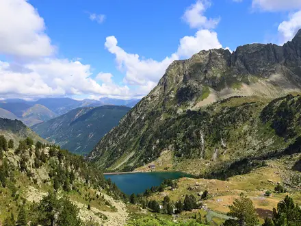
- Aiguestortes i Estany de Sant Maurici National Park: Catalonia's only national park, with granite terrain and around 200 glacial lakes. The GR11 threads through its lake district past refuges such as Colomers.
- Collado de Tebarray: At roughly 2,782 m, this is the highest point on the GR11. The approach above Respomuso is steep scree, with snow possible into summer.
- Benasque and the Posets-Maladeta massif: The route passes through the Benasque valley below the Maladeta range and Aneto, the highest summit in the Pyrenees. Aneto is an optional off-route objective for suitably prepared hikers.
- Cap de Creus: The Mediterranean finish is a wind-shaped rocky headland and natural park. It marks the easternmost point of mainland Spain and the end of the Atlantic-to-Mediterranean crossing.
Challenges to expect
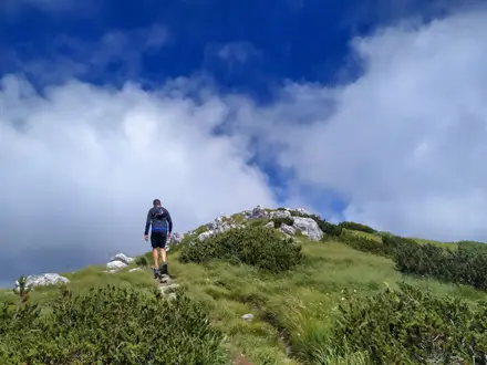
Expect sustained mountain difficulty: around 40,000 m of ascent, rocky and dirt trails, steep scree, remote stretches and around a dozen passes above 2,500 m. Snow can linger on high passes into mid-June and beyond, so July to September is safest for the central sections. Waymarking is red-and-white GR throughout, but self-sufficiency matters between villages and refugios. No permit is needed for the GR11 itself, but national parks may restrict wild camping or bivouacking.
HikeList Score
GR11 (Spanish Pyrenees Border) scored 74/100 on HikeList's trail-quality metrics.
See score breakdownHide breakdown
- Ideal length 52
- Balanced challenge 44
- Scenery & wildness 98
- Varied terrain 64
- Accommodation 92
- Food & support 81
- Path quality 98
- Season flexibility 76
Computed from length, challenge, scenery & wildness, terrain variety, accommodation, food & support, path quality and season flexibility.
 France
Show more data Show less
- Mountainous
- Forest
- Rocky
- Dirt
- Huts
- Hostels
- Hotels
- Campsites
- Wild Camping Spots
- Pet Friendly
- Water Sources
- Campsites
- Shelters
Photos from hikers
Taken on the trail by people who've reviewed GR11 (Spanish Pyrenees Border).
Reviews
How would you rate GR11 (Spanish Pyrenees Border)?
Tap a star to start your review — you could be the first.