Gower Way
How would you rate Gower Way?
Tap a star to share your experience and help other hikers.
Gower Way: A Complete Hiking Guide
HikeList Score
Gower Way scored 89/100 on HikeList's trail-quality metrics.
See score breakdownHide breakdown
- Ideal length 66
- Balanced challenge 100
- Scenery & wildness 85
- Varied terrain 100
- Accommodation 100
- Food & support 88
- Path quality 98
- Season flexibility 89
Computed from length, challenge, scenery & wildness, terrain variety, accommodation, food & support, path quality and season flexibility.
The Gower Way is a 56 km point-to-point walk across the Gower Peninsula and the historic Lordship of Gower in south Wales. Usually walked in 2–3 days, it is a moderate route linking upland moor, reservoirs, farmland, Cefn Bryn and the coast at Rhossili. It suits fit walkers who want a compact Welsh backpacking route with varied terrain rather than a pure coastal trail. If you are comparing Welsh walks, also see the upland Beacons Way, the Anglesey Coastal Path and the shorter Aber Falls Walk.
Route Overview
Walk north to south from Penlle'r Castell, on Mynydd y Gwair, to marker stone 0 at Rhossili by the coastguard lookout above Worm's Head. This direction is recommended because the numbered marker stones count down from 50 to 0 and the finish delivers the view over Rhossili Bay. Key places include Felindre, the Lower and Upper Lliw Reservoirs, Gorseinon/Gowerton, Three Crosses, Cefn Bryn and Reynoldston. The route is point-to-point, so plan start and finish transport rather than a simple car loop. The official three-section split is North, Middle and South, commonly used for a 2–3 day itinerary.
Gower Way History
The Gower Way was conceived by the Gower Society to mark the Millennium, planned by the late Peter Thomas, a former Society footpaths officer, with Gordon Howe. It was inaugurated by the Prince of Wales, then Prince Charles, in July 1998, with a commemorative plaque on Cefn Bryn above Penmaen. The trail links existing footpaths, bridleways, permissive paths and lanes through the ancient Lordship of Gower, passing heritage that includes Bronze Age dolmens, Iron Age forts, medieval platform sites, holy wells, Norman castles and churches.
Notable highlights
- Penlle'r Castell (~370 m): The northern start and high point of the route, with the remains of a late-13th-century Marcher-lord stronghold on Mynydd y Gwair and wide upland views north of Swansea.
- Lliw Reservoirs: The Lower and Upper Lliw reservoirs sit in the wooded Lliw valley, giving a sheltered break from the open moorland and a good area for birdwatching.
- Cefn Bryn: This long red-sandstone ridge is known as the “backbone of Gower” and gives broad views across the peninsula.
- Arthur's Stone (Maen Ceti): A Neolithic burial chamber on Cefn Bryn with a large capstone, linked in legend to King Arthur and one of Gower’s best-known prehistoric monuments.
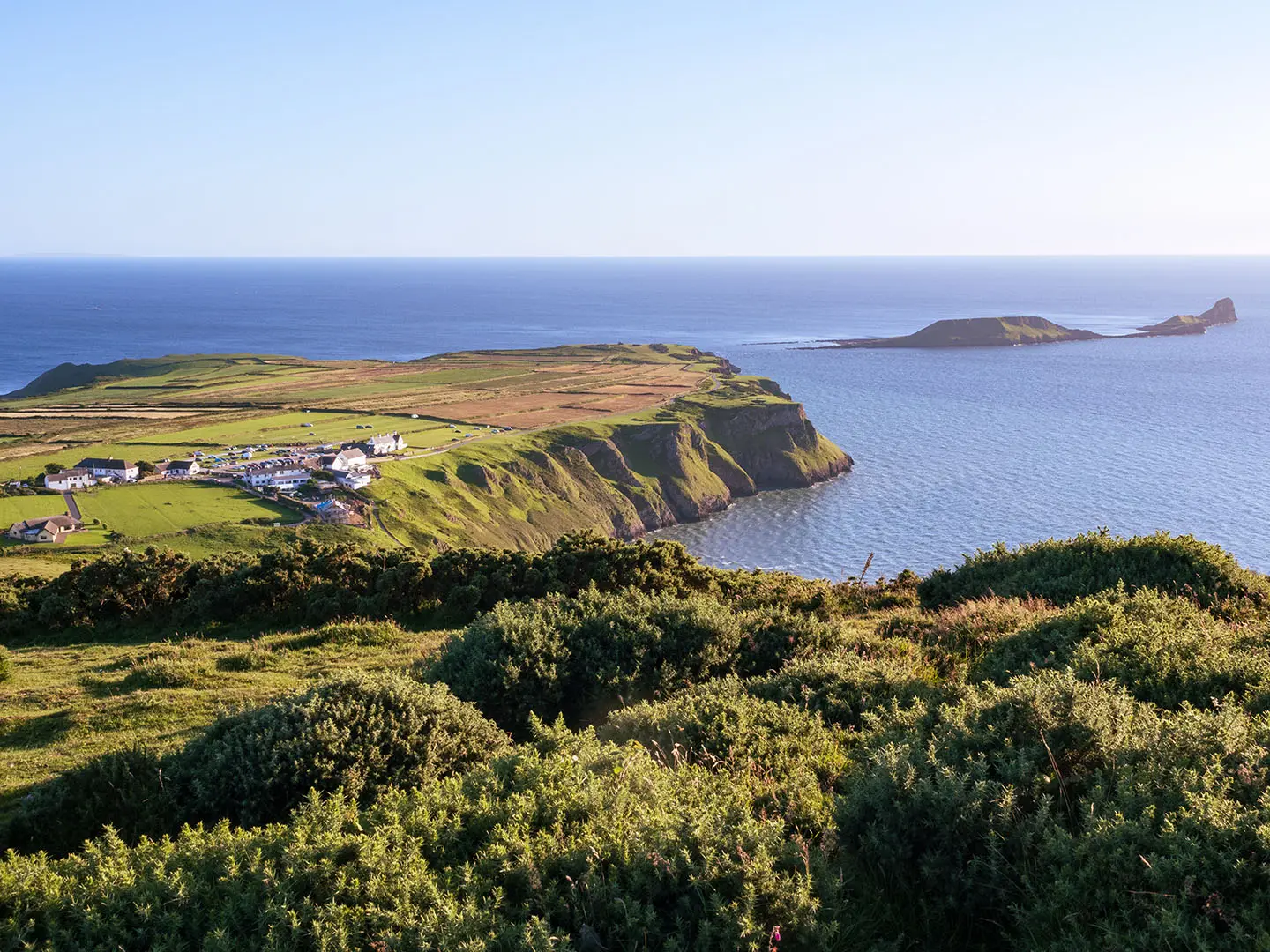
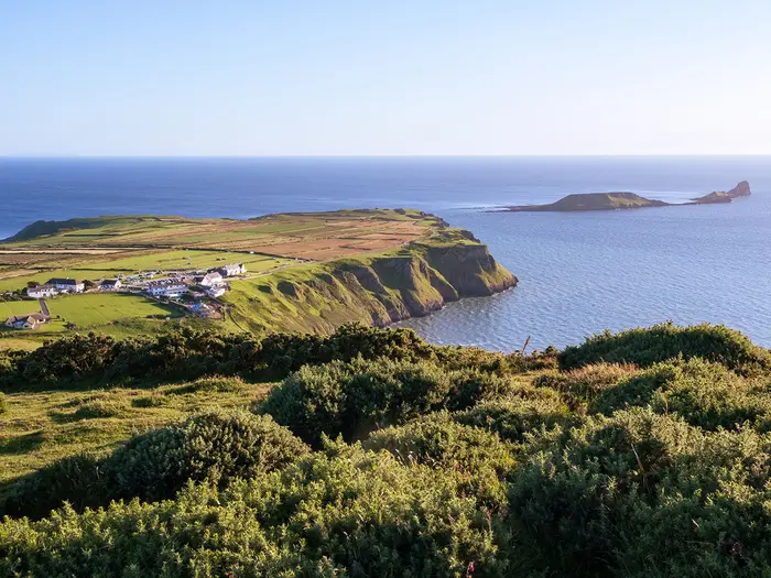
- Rhossili Bay and Worm's Head: The finish overlooks the three-mile beach of Rhossili Bay and the tidal islet of Worm’s Head, a dramatic coastal endpoint with seals and seabirds.
Challenges to expect
Expect varied going rather than sustained mountain terrain: moorland and heath, farm tracks, grassy ridge, lanes, a former railway path and rocky or uneven sections. The uplands can be muddy after rain and exposed in poor weather. Navigation is helped by numbered marker stones and route discs, with signage improved in 2024, but carry OS Explorer 164 and 165. There is no accommodation directly on the route, so book nearby villages or plan camping carefully.
HikeList Score
Gower Way scored 89/100 on HikeList's trail-quality metrics.
See score breakdownHide breakdown
- Ideal length 66
- Balanced challenge 100
- Scenery & wildness 85
- Varied terrain 100
- Accommodation 100
- Food & support 88
- Path quality 98
- Season flexibility 89
Computed from length, challenge, scenery & wildness, terrain variety, accommodation, food & support, path quality and season flexibility.
 United Kingdom
 Wales
WalesShow more data Show less
- Moorland
- Heath
- Farmland
- Limestone Plateau
- Ridge
- Coastal
- Dirt
- Grass
- Rocky
- Gravel
- B&Bs
- Hotels
- Inns
- Campsites
- Wild Camping Spots
- Family Friendly
- Pet Friendly
- Restrooms
- Water Sources
- Campsites
- Picnic Areas
Download Our Full Guide to Gower Way FREE!
Get our comprehensive guide to this hike for free. Save it for later reading or print out at home.
In these collections
Photos from hikers
Taken on the trail by people who've reviewed Gower Way.
Gower Way: The Complete Guide
 i
Image by Pete
i
Image by Pete The Gower Way is a compact but genuinely varied cross-country walk across Penrhyn Gŵyr, linking the high moorland of Penlle'r Castell with the sea cliffs above Rhossili. It suits reasonably fit walkers who want more than a coast path: upland heath, reservoirs, farmland, ridge walking and a final clifftop finish above Worm's Head.
Walked north to south, the numbered Gower Society stones count down from 50 to 0, giving the route a clear sense of progress. The line crosses Mynydd y Gwair / Mawr, drops through the wooded Lliw valley, passes through the Gowerton area, then climbs onto Cefn Bryn before ending above Rhossili Bay.
This is also one of the best short Welsh trails for landscape history. Maen Ceti (Arthur's Stone), old chapels, castle earthworks and prehistoric features sit naturally along the route rather than as detours.
The challenge is not technical difficulty, but logistics and conditions. The northern end is remote, wet and exposed in poor weather, there is essentially no accommodation directly on the trail, and transport to Penlle'r Castell needs planning before setting off.
This guide covers stages, day plans, accommodation, food, transport, terrain and the common mistakes to avoid.
Stage-by-Stage Guide
Stage 1: Penlle'r Castell to Gorseinon / Gowerton — approx. 24 km
This is the hardest and most committing stage of the Gower Way. It starts at the route’s high point, Penlle'r Castell, beside marker stone 50 and the earthwork remains of the medieval castle, then crosses the exposed uplands of Mynydd y Betws / Mynydd y Gwair before dropping towards the Lliw valley and the more settled ground around Felindre, Pontlliw, Gorseinon and Gowerton.
Underfoot, expect a genuine upland day rather than an easy village-to-village walk. The northern moorland is often wet and muddy after rain, with open heath, grass, dirt, rough ground and stream crossings; waterproofs, boots and a map are essential in poor weather. Once the route reaches the wooded Lliw valley and the Upper and Lower Lliw Reservoirs, the walking becomes more sheltered, before continuing through a mix of tracks, lanes, field paths and metalled sections towards the urban fringe.
Key landmarks on this stage include Penlle'r Castell itself, the high moorland views north of Swansea, the Upper and Lower Lliw Reservoirs, Felindre and Nebo Chapel, Pontlliw, then the Gorseinon / Gowerton area. The reservoirs give the stage its main change of character: a green, enclosed section after the open uplands, with the chance of seeing peregrine falcons, ravens and red kites.
Do not rely on food or drink at the start. Penlle'r Castell is remote and has no services at the trailhead, so begin with enough water and food for the moorland section. Felindre, Pontlliw, Gorseinon and Gowerton are the practical places to look for shops, cafés, pubs or other services, but exact opening times and availability should be checked before travelling.
Accommodation is best planned off-route or at the edge of the route. Gorseinon, Gowerton and Swansea are the most practical overnight bases after this stage, with B&Bs, inns, hotels and other options in the wider area. There is essentially no accommodation directly on the Gower Way itself, so book ahead and allow for the transfer between the trail and the bed for the night.
Transport is the main planning issue for this stage. Penlle'r Castell has no public transport to the trailhead, so most walkers need a car drop, taxi, or a pre-arranged approach via the Felindre / Mynydd y Gwair area using the pre-bookable DANSA demand-responsive minibus. This should be checked before travelling. Gowerton has a railway station on the Swansea District / West Wales line, and Swansea is the main rail hub for the area.
Navigation is helped by the Gower Way discs and numbered marker stones, which count down from stone 50 at Penlle'r Castell towards stone 0 at Rhossili. On the moor, however, visibility can deteriorate quickly, and waymarks should not be treated as a substitute for OS Explorer 164 and 165 or a reliable GPX. Take particular care not to underestimate this stage simply because the route is waymarked.
The main warnings are exposure, wet ground, mud, stream crossings and the lack of facilities on the upland section. In poor weather, this stage can feel much more serious than its modest height suggests. Short road and lane sections also require normal road-walking care, especially in low light or rain.
Stage 2: Gorseinon / Gowerton to Reynoldston — approx. 19 km
This middle stage leaves the more built-up edge of Gorseinon and Gowerton and works south-west across farmland, field paths and quieter inland Gower. It is less remote than the northern stage, but it is still a varied cross-country walk rather than a continuous surfaced path.
The route passes through or near Three Crosses, Welsh Moor and Park Woods (Gelli Hir), before climbing onto the long red-sandstone ridge of Cefn Bryn. This ridge is one of the defining features of the Gower Way: open, broad-backed and exposed, with views across much of Penrhyn Gŵyr (the Gower Peninsula) in clear weather.
A major highlight is Maen Ceti (Arthur's Stone), the Neolithic burial chamber on Cefn Bryn with its huge capstone. The route then continues towards Reynoldston, a green-centred Gower village below the ridge and one of the most useful overnight bases on the southern half of the walk.
Terrain is mixed throughout the day. Expect grass and dirt paths, farm tracks, woodland paths, lanes and short metalled sections, with a stretch of dismantled-railway path on the wider route corridor. After rain, field paths and woodland sections can be muddy, and the open ridge can be windy even when the lower ground feels sheltered.
Food and water planning is easier than on Stage 1, but it still needs attention. Gorseinon / Gowerton at the start and Reynoldston at the end are the most reliable planning points, with Three Crosses and other settlements along the way offering possible options depending on route line and opening times. Carry enough food and water to walk the full stage without depending on a mid-stage stop; village services should be checked before travelling.
Reynoldston is the natural overnight stop for this stage, with accommodation in or around the village and the wider Gower area. As with the rest of the route, there is no continuous chain of accommodation directly on the path, so booking ahead matters, especially in the main walking season. Parkmill, Swansea and other nearby villages can also work as bases if transport is arranged.
Road access is generally better on this stage than on the northern uplands, with Gorseinon, Gowerton, Three Crosses and Reynoldston all providing practical access points. Public transport details for intermediate stops can change, so current bus times and connections should be checked before travelling.
For navigation, follow the Gower Way discs and the numbered stones as they continue counting down towards Rhossili. The main places to stay attentive are field-path junctions, woodland edges around Park Woods, transitions onto and off Cefn Bryn, and any lane crossings. Carry OS Explorer 164 and 165 rather than relying only on waymarks.
The principal warnings are mud after rain, exposed conditions on Cefn Bryn, working farmland and short road sections. Keep dogs under close control where livestock may be present, close gates, and allow extra time if wet fields make progress slower than expected.
Stage 3: Reynoldston to Rhossili — approx. 13 km
The final stage is the shortest of the three, but it still has plenty of variety. From Reynoldston the route heads through the western Gower landscape towards Knelston, Llanddewi and Rhossili, gradually moving from inland village country to the limestone plateau and clifftop above the Atlantic-facing coast.
The walking is generally less strenuous than the northern moorland day, but it remains a cross-country stage with field paths, farm tracks, lanes, grass, dirt and some rockier or harder sections near the coast. After wet weather, expect mud on field paths and take care on any polished or uneven ground.
The finish is one of the strongest moments on the Gower Way. The route ends at marker stone 0 by the old coastguard lookout on the clifftop above Worm's Head, with views over Rhossili Bay and the tidal serpent-shaped islet beyond. The numbered stones make the north-to-south direction particularly satisfying here, as the count reaches zero at the coast.
Food and water are best organised around Reynoldston at the start and Rhossili at the finish. Knelston and Llanddewi are useful landmarks, but do not assume dependable mid-stage resupply without checking current services. Carry enough water and snacks to complete the stage comfortably, particularly in warm weather or if lingering at the coast.
For accommodation, Rhossili and the wider south-west Gower area are the obvious targets, with Swansea also possible if returning by bus or arranged transport. As elsewhere on the trail, book ahead and do not assume accommodation sits directly on the route.
Transport is strongest at the southern end. Rhossili has a bus terminus with Swansea services 118/119 via Reynoldston, Knelston and Scurlage, and service 114 is also associated with Rhossili. Current timetables should be checked before travelling, especially if finishing late in the day or outside the main season.
Navigation is generally straightforward in good visibility thanks to the Gower Way waymarks and marker stones, but do not switch off near the end: field-path junctions, village lanes and the final approach to the clifftop still require attention. OS Explorer 164 covers the Gower coast and should be carried.
The main warnings are normal farmland care, mud after rain, short road sections and the clifftop environment at Rhossili. Keep well back from cliff edges in wind or poor visibility. If continuing beyond the trail finish towards Worm's Head, tide times must be checked before setting out; the Gower Way itself finishes at the lookout and does not require the tidal crossing.
Recommended Itinerary
The most practical way to walk the Gower Way is north to south, from Penlle'r Castell to Rhossili. This puts the exposed upland sector first, lets the numbered marker stones count down from 50 to 0, and finishes on the Rhossili clifftop above Worm's Head.
Distances below use the route stages in the guide. Accommodation is not generally on the trail itself, so the overnight places are best treated as practical bases rather than guaranteed door-to-door stops.
Standard itinerary: 3 days
This is the best-balanced schedule for most fit walkers. It follows the three practical sectors: the long northern moorland day, the middle farmland-and-ridge day, and the shorter final walk to Rhossili.
| Day | From | To | Approx. distance | Why this stage makes sense | Services/accommodation notes |
|---|---|---|---|---|---|
| 1 | Penlle'r Castell | Gorseinon / Gowerton | 24 km | This tackles the most strenuous section first: remote upland around Mynydd y Betws / Mawr, the Lliw Reservoirs, Felindre and the approach towards the lower ground around Gorseinon and Gowerton. Starting early is sensible because the northern sector is wet, exposed and has the most awkward access. | There are no reliable trail facilities on the upland start. Arrange transport to Penlle'r Castell in advance, and carry food, water and waterproofs. Overnight logistics are usually based around Gorseinon, Gowerton or Swansea rather than directly on the path. |
| 2 | Gorseinon / Gowerton | Reynoldston | 19 km | A varied middle day over field paths, lanes, old railway alignment and the climb towards Cefn Bryn. Reynoldston is a natural southern-half base below the ridge, making it a sensible stop before the final coastal stage. | Gowerton has a railway station and is useful for section-walkers. Reynoldston has the best practical role as an overnight base on this part of the route, but accommodation should be booked ahead. |
| 3 | Reynoldston | Rhossili | 13 km | A shorter final day leaves time for Cefn Bryn, Maen Ceti (Arthur's Stone), the approach through the south-west Gower villages and the finish at marker stone 0 above Worm's Head. It also gives a buffer for onward buses from Rhossili. | Rhossili has a bus terminus with Swansea services 118/119 via Reynoldston, Knelston and Scurlage, and service 114. Check current bus times before travelling. Check Worm's Head tide times separately if continuing beyond the trail finish to the tidal islet. |
Slower variant: 4 days
A four-day itinerary suits walkers who want shorter days, are carrying heavier packs, or do not want to combine the exposed northern moorland with a long walk-out to Gorseinon or Gowerton. The trade-off is logistics: splitting the northern or middle sectors can make accommodation and transport more awkward.
| Day | From | To | Approx. distance | Why this stage makes sense | Services/accommodation notes |
|---|---|---|---|---|---|
| 1 | Penlle'r Castell | Felindre | 6.6 miles | A short but valuable first stage over the remote upland ground from the high northern start. It reduces the pressure on the hardest sector and gives more time for poor underfoot conditions. | Felindre is on the route, but do not assume trail accommodation. A pre-arranged taxi, lift or off-route base may be needed. The DANSA demand-responsive minibus serves Felindre / Mynydd y Gwair, but bookings and current operation should be checked before travelling. |
| 2 | Felindre | Gorseinon / Gowerton | 6.1 miles | Completes the northern sector through the Lliw valley and lower ground, leaving time to reposition or use Gowerton for rail access. | Gorseinon, Gowerton or Swansea are the most practical overnight bases. Gowerton is useful for rail connections. |
| 3 | Gorseinon / Gowerton | Reynoldston | 19 km | Keeps the full middle sector together, avoiding an uncertain overnight in a smaller intermediate village. Expect mixed farmland, tracks, lanes and the approach to Cefn Bryn. | Book Reynoldston or nearby accommodation ahead. If splitting this day around Three Crosses or Cillibion instead, check official mapping and accommodation before booking. |
| 4 | Reynoldston | Rhossili | 13 km | A relaxed final stage with time for Maen Ceti, the open ridge and the Rhossili finish. | Rhossili is the easiest end point for public transport. Check current Swansea bus times before committing to a finish time. |
Faster variant: 2 days
A two-day Gower Way is possible for strong walkers with light packs and firm transport plans. It is not the best option for a first multi-day walk, because the first day is still the wet, exposed northern sector and the second day combines the middle and southern sectors.
| Day | From | To | Approx. distance | Why this stage makes sense | Services/accommodation notes |
|---|---|---|---|---|---|
| 1 | Penlle'r Castell | Gorseinon / Gowerton | 24 km | This keeps the strenuous northern sector as a single committing day and ends near the best practical transport/accommodation hub on the route. | Arrange the upland start carefully: there is no public transport to Penlle'r Castell itself. Use a car drop, taxi, or pre-booked local transport arrangement where available. |
| 2 | Gorseinon / Gowerton | Rhossili | 32 km | Combines the middle sector to Reynoldston with the final section to Rhossili. This is a long day over varied ground, including Cefn Bryn and the south-western approach to the coast. | Start early and check the last practical bus options from Rhossili before setting off. Accommodation at the finish or onward travel to Swansea should be arranged in advance, especially in busy periods. |
Planning the Route
The Gower Way is best planned around its logistics rather than its mileage. The walking is compact, but accommodation is not conveniently strung along the path, and the northern start at Penlle'r Castell is remote with no public transport to the trailhead.
Most walkers should allow three walking days. This gives a sensible progression from the wet uplands and Lliw valley to the farmland, Cefn Bryn and Rhossili coast without having to rush the exposed northern sector.
How many days to allow
| Itinerary | Best for | Practical notes |
|---|---|---|
| 2 days | Fit walkers moving quickly with transport already arranged | Usually means one long day by combining two of the three sectors. This is possible, but it leaves little margin for wet upland ground, navigation delays or awkward transfers. |
| 3 days | Most independent walkers | The natural plan: Penlle'r Castell to Gorseinon / Gowerton, then to Reynoldston, then to Rhossili. This matches the route’s practical hubs and keeps the hardest northern ground separate. |
| 3–4 days | Walkers wanting shorter days, poor-weather flexibility or easier section logistics | Extra time is most useful on the northern half, where access and escape options need more thought. A split around Felindre may work if transport is arranged, but do not assume convenient accommodation on the line of the route. |
The route is generally better as a steady three-day walk than as a fast two-day crossing. The northern moorland section can be wet, exposed and slower than its distance suggests, while the southern half rewards time for Cefn Bryn, Maen Ceti (Arthur's Stone), Reynoldston and the finish above Rhossili Bay.
Direction of travel
Walking north to south, from Penlle'r Castell to Rhossili, is the cleanest way to plan it. The numbered Gower Society stones count down from stone 50 at the northern high point to stone 0 by the old coastguard lookout above Worm's Head, and the route finishes with the strongest coastal view.
Reverse direction is possible, but it makes the final day the remote upland end, which is less convenient for transport. If walking south to north, arrange the Penlle'r Castell pick-up before starting rather than leaving it to the last day.
Natural stages and overnight bases
Daily stages are dictated less by terrain than by where it is practical to sleep or get transport. There is essentially no accommodation directly on the route, so most walkers use nearby bases such as Gorseinon / Gowerton, Reynoldston, Parkmill, Swansea or other Gower villages and then arrange short transfers where needed.
A practical three-day plan is:
| Stage | Route | Approx. distance | Planning focus |
|---|---|---|---|
| Day 1 | Penlle'r Castell to Gorseinon / Gowerton | 24 km | Remote start, exposed upland, wet ground, no facilities on the northern sector. |
| Day 2 | Gorseinon / Gowerton to Reynoldston | 19 km | Easier access, mixed farmland and ridge walking, useful mid-route base at Reynoldston. |
| Day 3 | Reynoldston to Rhossili | 13 km | Shorter final day, Cefn Bryn / limestone plateau and clifftop finish; bus exit from Rhossili. |
Book accommodation before committing to the itinerary. If staying off-route, factor in taxi, bus or lift arrangements at the start and end of each day, especially around the northern sector.
Section hiking and shortening the route
Section hiking is practical, but the sections are not equally easy. Gowerton has a railway station and Swansea is the main rail hub, which makes the Gorseinon / Gowerton end of the northern sector useful for access. Rhossili is also relatively straightforward because it has a bus terminus with Swansea services including 118 / 119 and 114; current timetables should be checked before travelling.
The awkward part is Penlle'r Castell. There is no public transport to the trailhead, so a section walk involving the northern end needs a car drop, taxi, or a pre-bookable DANSA demand-responsive minibus to the Felindre / Mynydd y Gwair area. Bookings and operating details should be checked before travelling.
Shortening a day is easiest in the middle and southern parts of the route, where villages, roads and bus-linked settlements are closer together. The upland north is less forgiving: once committed to the moorland and reservoir section, carry what is needed and do not rely on finding services en route.
Food, water and resupply
The northern sector should be treated as a self-sufficient walking day. Carry food and enough water from the start, and do not plan around facilities between Penlle'r Castell, the Mynydd y Gwair / Mawr uplands and the Lliw Reservoirs.
Reynoldston is the most natural southern-half base and resupply point. Gorseinon / Gowerton and Swansea are also useful for pre-walk supplies or overnight logistics, but opening times and exact services should be checked before travelling.
Water planning matters more than the route length suggests. The presence of reservoirs and streams does not remove the need to carry drinking water, particularly on warm days or if walking the exposed moorland slowly.
Navigation and weather planning
The Gower Way is waymarked with green-edged Gower Way discs and numbered marker stones, and signage was refreshed in 2024. Even so, carry proper mapping: OS Explorer 164 covers Gower, OS Explorer 165 covers Swansea, and OS Landranger 159 is also relevant.
The northern uplands are the main navigation and weather concern. Low cloud, rain, wet heath, mud and stream crossings can slow progress, and the final climb to Penlle'r Castell is exposed. Waterproofs, proper boots and a map-and-compass backup are sensible even in the main walking seasons.
On the southern end, the Gower Way finishes at Rhossili above Worm's Head. If continuing beyond the official finish onto Worm's Head itself, tide times must be checked before travelling; it should not be treated as an automatic add-on to the route.
The key planning priorities
For this route, the essential planning jobs are:
- arrange access to or from Penlle'r Castell before starting;
- book accommodation or off-route bases in advance;
- carry full food and water for the remote northern sector;
- check current bus times for Rhossili and Swansea connections;
- carry OS mapping despite the waymarking;
- allow weather margin for the wet, exposed uplands;
- check any current upland access or diversion notes before relying on the route line.
There is no need to overcomplicate the itinerary, but the remote northern end should not be underestimated. A simple three-day plan with transport fixed at both ends is usually the most reliable way to walk the Gower Way independently.
Towns, Villages and Overnight Stops
The Gower Way is awkward for accommodation because there is essentially no accommodation directly on the line of the route. Most walkers use nearby villages and towns as bases, then arrange lifts, taxis, buses or short transfers to and from the trail.
For a 3-day walk, the most practical overnight pattern is usually around Gorseinon / Gowerton after the northern sector and Reynoldston before the final walk to Rhossili. Book accommodation ahead, especially in the Gower villages, and check current food opening times before relying on evening meals or resupply.
| Place | Best use for walkers | Overnight practicality |
|---|---|---|
| Penlle'r Castell / Mynydd y Gwair uplands | Remote start or finish of the northern sector | Poor — no facilities at the trailhead |
| Felindre / Pontlliw | Access points for the northern sector | Possible nearby, but plan transport carefully |
| Gorseinon / Gowerton | Main practical stop after the northern sector | Good — useful transport and services base |
| Three Crosses / Welsh Moor | Mid-route passage on the middle sector | Only if accommodation is pre-arranged |
| Reynoldston | Best southern-half overnight stop | Good — natural base and resupply point |
| Knelston / Llanddewi | Late-stage villages before Rhossili | Useful for buses/route position, not a primary stop unless arranged |
| Rhossili | Finish point and coastal overnight option | Good finish logistics; book ahead |
| Swansea | Off-route rail hub and fallback base | Very useful for arrivals, departures and extra nights |
Penlle'r Castell and the Mynydd y Gwair / Mawr Uplands
Penlle'r Castell is the northern end of the Gower Way and the route's high point, reached on the uplands of Mynydd y Betws / Mawr. It is marked by stone 50 beside the earthwork remains of the medieval castle, near the Clydach–Ammanford road.
This is not a practical overnight stop. There are no facilities at the trailhead, no public transport to the start, and the surrounding upland is exposed, wet and remote in poor weather.
Most walkers either arrange a car drop or taxi to reach Penlle'r Castell, or use nearby access via Felindre / Mynydd y Gwair with the pre-bookable DANSA demand-responsive minibus where suitable. Bookings, operating days and pickup points should be checked before travelling.
Do not start the northern sector short of food, water or waterproofs. The walk from Penlle'r Castell towards the Lliw valley and Gorseinon / Gowerton is the most strenuous and least forgiving part of the route.
Upper and Lower Lliw Reservoirs
The Upper and Lower Lliw Reservoirs sit on the northern sector between the open uplands and the lower settlements around Felindre and Pontlliw. They provide a sheltered change of terrain after the exposed moorland, but they should be treated as a walking section rather than a service stop.
No overnight facilities should be assumed here. Carry what is needed for the whole northern sector, particularly if walking north to south from Penlle'r Castell.
Felindre
Felindre is the first small village area reached after the reservoirs when walking south from Penlle'r Castell. It is useful mainly as an access point for the northern sector rather than as a guaranteed overnight base.
The pre-bookable DANSA demand-responsive minibus serves Felindre / Mynydd y Gwair, making it relevant for walkers trying to avoid a car at the remote northern end. This should be booked and checked before travelling.
Accommodation, food and shop options in or around Felindre should not be assumed without checking in advance. If using it to break the northern sector, make firm arrangements for both the overnight stay and the next day's return to the trail.
Pontlliw
Pontlliw lies near the northern-sector logistics corridor between Felindre and the more substantial service area of Gorseinon / Gowerton. It can be useful for access, pickup or taxi arrangements, especially for walkers not completing the full Penlle'r Castell to Gorseinon / Gowerton stage in one push.
It is not one of the main overnight hubs for the Gower Way. Accommodation and food availability should be checked before building an itinerary around it.
Gorseinon and Gowerton
Gorseinon and Gowerton are the most practical places to stop after the long northern sector. They sit at the lower, more settled end of the Penlle'r Castell to Gorseinon / Gowerton stage and are far easier for accommodation and transport than the uplands.
Gowerton has a railway station on the Swansea District / West Wales line, while Swansea is the main rail hub for the wider area. This makes Gorseinon / Gowerton useful for walkers arriving by public transport, section-walking, or needing a bail-out point after the most strenuous day.
Accommodation in this area is more practical than trying to stay on the route itself. Expect to use B&Bs, inns, hotels or nearby options rather than trail-specific lodging, and book ahead.
Food and resupply are also more likely here than on the northern moorland or the later rural sections. Opening times still need checking, particularly for evening arrivals.
Three Crosses
Three Crosses comes on the middle part of the route between Gowerton and the Gower interior. It can be a useful progress marker and potential access point, but it is not as strong an overnight choice as Gorseinon / Gowerton or Reynoldston.
Use Three Crosses as an overnight stop only if accommodation and transport have been arranged in advance. Do not rely on turning up and finding walker-specific facilities on the route.
Welsh Moor and Park Woods (Gelli Hir)
Welsh Moor and Park Woods (Gelli Hir) are part of the quieter middle section as the route moves away from the more serviced Gowerton area towards Cefn Bryn. They are walking terrain rather than overnight bases.
There is no reason to plan a night specifically here unless staying off-route in pre-booked accommodation nearby. Carry food and water through this section rather than assuming facilities on the path.
Cefn Bryn and Maen Ceti (Arthur's Stone)
Cefn Bryn is the long ridge crossed on the southern half of the Gower Way, with Maen Ceti (Arthur's Stone) passed on the route. It is one of the key reasons to walk the trail, but it is not an accommodation hub.
The ridge is exposed and should be treated as a weather-dependent walking section. In mist, wind or heavy rain, navigation and clothing matter more than village logistics.
For overnight planning, Reynoldston is the practical base below this part of the route. Avoid planning to finish a day high on the ridge unless a clear onward transfer or accommodation arrangement is already in place.
Reynoldston
Reynoldston is the best overnight stop on the southern half of the Gower Way. It sits below Cefn Bryn and is a natural base between the middle section and the final walk towards Rhossili.
For a 3-day itinerary, this is the logical second night after Gorseinon / Gowerton. It keeps the final stage to Rhossili short and manageable, while allowing time for the Cefn Bryn crossing without rushing.
Reynoldston is also a useful resupply point, but individual shops, pubs and accommodation should be checked before travelling. Availability can be limited in smaller Gower villages, so advance booking is strongly advised.
Swansea bus services 118/119 to Rhossili run via Reynoldston, making it one of the more practical Gower villages for walkers without a car. Timetables should be checked before finalising the itinerary.
Knelston
Knelston lies on the approach towards the western end of the route, between Reynoldston and Rhossili. It is more useful as a route and transport reference point than as a main overnight stop.
The Swansea to Rhossili bus services 118/119 run via Knelston and Scurlage. This can help with section-walking or shortening the final day, but current timetables should be checked before relying on them.
Accommodation and food options should be arranged in advance if planning to stop here. Most walkers will find Reynoldston or Rhossili simpler for overnight logistics.
Llanddewi
Llanddewi sits on the final inland approach before the route reaches Rhossili. It is a quiet passage point rather than a major service centre for Gower Way walkers.
Do not rely on Llanddewi for accommodation, food or resupply unless specific arrangements have been made beforehand. It is best treated as part of the final walking day from Reynoldston to Rhossili.
Rhossili
Rhossili is the southern finish of the Gower Way, where marker stone 0 stands by the old coastguard lookout on the clifftop above Worm's Head. It is the most rewarding place to end the route, but it is still worth planning the final logistics carefully.
Rhossili has a bus terminus with Swansea services 118/119 via Reynoldston, Knelston and Scurlage, and service 114. Bus times vary, so check the latest timetable before committing to a same-day onward journey.
Staying in or near Rhossili can make sense after finishing, especially if the final day has been timed to enjoy the coast and the Worm's Head view rather than rush for transport. Accommodation should be booked ahead.
Food, cafés, pubs and shop opening times should also be checked before arrival, particularly outside peak summer periods or late in the day. If continuing beyond the official finish to visit Worm's Head, tide times must be checked before travelling.
Swansea
Swansea is not on the Gower Way, but it is the main transport and fallback accommodation base for the route. It is the principal rail hub and the logical place for arrivals, departures, spare nights and taxi connections.
Walkers using public transport often combine Swansea with Gowerton rail station, Rhossili buses, and pre-arranged road transport to or from the remote Penlle'r Castell end. This can be simpler than trying to link every overnight directly on the trail.
Swansea is also useful if accommodation in smaller Gower villages is full. The trade-off is that each walking day may need a bus, taxi or lift to return to the route.
Llanrhidian and Parkmill
Llanrhidian and Parkmill are nearby Gower bases rather than core waypoints on the standard stage split. They can be useful when Reynoldston or other villages are full, or when building a more relaxed itinerary with transfers.
Accommodation in these villages may suit walkers using taxis or local buses to connect with the route. Exact transport links, walking connections and availability should be checked before booking.
Neither should be treated as an automatic on-route stop. They work best for walkers who are comfortable planning short off-route transfers rather than expecting the Gower Way to pass the door.
Getting to the Start
The Gower Way is usually walked north to south, starting at Penlle'r Castell on the uplands of Mynydd y Betws / Mawr and finishing at Rhossili. The start is remote: there is no public transport to marker stone 50 itself, so the main planning task is the final approach to the upland trailhead.
By train
Swansea is the main rail hub for the route and the most practical place to arrive from elsewhere in the UK. From Swansea, continue towards the north-west side of the route by local transport, taxi or a pre-arranged lift.
Gowerton also has a railway station, on the Swansea District / West Wales line, and is useful for walkers basing themselves around Gowerton or Gorseinon before starting. It is not at the northern trailhead: Penlle'r Castell still requires onward road transport or a long approach via the route itself.
By bus
There is no standard public bus service to Penlle'r Castell trailhead. Do not plan around simply turning up at Swansea or Gowerton and catching a bus to the start.
The practical public-transport option for the northern end is the pre-bookable DANSA demand-responsive minibus serving Felindre / Mynydd y Gwair. This can help get walkers closer to the upland start area, but it must be arranged in advance and may not remove the need for a walk-in or onward lift depending on the booking and drop-off point. This should be checked before travelling.
For most walkers, the simplest plan is:
| Step | Practical option |
|---|---|
| Arrive in the area | Train to Swansea or Gowerton |
| Reach the north side of the route | Local transport towards Felindre / Pontlliw / Gorseinon, pre-booked DANSA minibus, taxi or lift |
| Reach Penlle'r Castell | Pre-arranged taxi or car drop to the upland start near the Clydach–Ammanford road |
By car
Penlle'r Castell is reached by road on the uplands north of Swansea, near the Clydach–Ammanford road. The trail starts at marker stone 50 beside the earthwork remains of the medieval castle, at grid reference SN665096.
A car drop is one of the most reliable ways to handle the northern start. Many walkers either arrange a lift to Penlle'r Castell and walk south, or leave the car elsewhere and book a taxi to the start.
Long-stay parking at or near the upland trailhead should not be assumed. If leaving a vehicle, use legal, formal parking where permitted, avoid blocking lanes or farm access, and arrange the end-of-walk return from Rhossili separately. This should be checked before travelling.
From the nearest airport
Airport access is not usually the limiting factor on this route; the difficult section is the final transfer from the Swansea / Gowerton area to Penlle'r Castell. If flying in, plan onward travel first to Swansea, then arrange the local transfer to the northern start by taxi, lift or the pre-bookable DANSA service where suitable.
The most convenient airport and onward journey will depend on current flight routes, rail connections and arrival time. This should be checked before travelling.
Where to stay before starting
There is essentially no accommodation directly on the Gower Way, and the northern start has no trailhead facilities. The most practical pre-walk bases are Swansea, Gowerton, Gorseinon, Pontlliw or Felindre, depending on how the transfer to Penlle'r Castell is being arranged.
Swansea gives the easiest rail access and the widest choice of services. Gowerton and Gorseinon are useful if starting with a taxi or lift to the uplands, while Felindre and Pontlliw put you closer to the northern route corridor but require more careful transport planning.
Accommodation should be booked ahead, especially if the first day is the full northern sector to Gorseinon / Gowerton. Start early enough to allow for the remote upland ground, wet conditions underfoot and the lack of services before descending towards the Lliw valley and Felindre.
Getting Home from the Finish
The Gower Way finishes at marker stone 0 by the old coastguard lookout above Worm's Head, just outside Rhossili. Unlike the remote northern start, Rhossili has public transport, but onward travel still needs planning because services are timetable-dependent and can be limited outside the main part of the day.
By train
There is no railway station at Rhossili. The practical rail connection is via Swansea, the main rail hub for the area.
Use the bus from Rhossili towards Swansea where possible, or pre-book a taxi if the bus times do not fit. Do not assume there will be a convenient late connection after finishing on the clifftop, especially if walking the final stage slowly or spending time around Rhossili Bay and Worm's Head.
Gowerton also has a railway station on the Swansea District / West Wales line, but Rhossili’s regular onward public transport is primarily towards Swansea. Rail times and connections should be checked before travelling.
By bus
Rhossili has a bus terminus and is served by Swansea buses 118 and 119 via places including Reynoldston, Knelston and Scurlage. Service 114 also serves Rhossili.
These buses are the main public-transport option for leaving the finish without a car. Check current timetables before committing to a finish-day plan, particularly on Sundays, bank holidays or outside summer.
If finishing late in the day, either aim for an earlier final stage, book accommodation locally, or arrange a taxi in advance. It is not sensible to rely on turning up at Rhossili after the last bus.
By car/taxi
A car left at Rhossili makes the finish simple, but the Gower Way is point-to-point, so walkers must decide before starting where the vehicle will be most useful. Many walkers arrange a car drop or taxi for one end of the route because Penlle'r Castell, the northern trailhead, has no public transport to the start itself.
If returning to a car left near the northern end, pre-book a taxi or lift rather than trying to solve it from Rhossili at the end of the walk. The transfer crosses the peninsula and should be treated as part of the route logistics, not an afterthought.
Taxi availability, fares and evening service should be checked before travelling.
From the nearest airport
Airport travel is not a key part of the Gower Way’s finish logistics. For walkers flying in or out, the practical approach is to connect through Swansea first, then use the Rhossili bus or a pre-booked taxi for the final leg.
Airport rail and coach connections change by operator and season, so onward flight-day travel should be checked before booking fixed tickets.
Where to stay at the finish
Staying near the finish is a good option if bus times are awkward, if the final day runs late, or if you want time for Rhossili Bay and Worm's Head after completing the trail. Rhossili and nearby Gower villages are the most convenient choices, with Swansea a more flexible base for onward rail travel.
Accommodation on and around the route is limited compared with larger trail centres, and there is essentially no accommodation directly on the line of the Gower Way for much of the walk. Book ahead, especially for weekends and holiday periods.
Which Direction Should You Walk?
The Gower Way is best planned north to south, from Penlle'r Castell to Rhossili. This is the natural direction of the route: the numbered Gower Society marker stones count down from stone 50 at Penlle'r Castell to stone 0 on the clifftop above Worm's Head.
Walking this way also gives the route its strongest sense of progression. You begin on the exposed uplands of Mynydd y Betws / Mawr, drop through the Lliw Reservoirs and the valley settlements, cross farmland and the Cefn Bryn ridge, then finish with the wide coastal view over Rhossili Bay and Worm's Head.
North to south: Penlle'r Castell to Rhossili
This is the recommended direction for most walkers.
The biggest practical advantage is the finish. Penlle'r Castell is remote and has no public transport at the trailhead, so it is better to deal with that awkward journey at the start, using a car drop, taxi, or pre-booked transport to the wider Felindre / Mynydd y Gwair area. This should be checked before travelling.
Finishing at Rhossili is much simpler. Rhossili has a bus terminus with Swansea services including 118/119 via Reynoldston, Knelston and Scurlage, plus service 114, making it a far easier place to leave the trail than the northern uplands.
The walking also feels more satisfying in this direction. The high point is at the start, so the route begins in wild, exposed country and gradually works towards the coast. There are still climbs and rough sections later on, especially around Cefn Bryn, but you avoid making the long climb up to Penlle'r Castell the final act of the walk.
South to north: Rhossili to Penlle'r Castell
Walking south to north is possible, but it is less convenient for most independent hikers.
The main benefit is an easy start: Rhossili can be reached by bus from Swansea. The problem is the finish. Ending at Penlle'r Castell leaves you on an upland trailhead with no public transport, so a taxi, lift, car shuttle or other pre-arranged pick-up becomes essential.
The reverse direction also puts the most awkward northern ground late in the walk. The sector towards Penlle'r Castell is the most strenuous part of the route, with wet, exposed upland, stream crossings and a long final climb to the castle area. In poor weather, that is a demanding way to finish.
Recommendation
Walk the Gower Way north to south: Penlle'r Castell to Rhossili. It matches the marker-stone sequence, gives the best landscape progression, handles the remote northern trailhead at the start rather than the end, and finishes at the most practical and memorable point on the route.
Accommodation Along the Route
Accommodation is the main logistical constraint on the Gower Way. There is essentially no accommodation directly on the line of the route, so most walkers treat the overnight stops as nearby bases rather than true trail-door stops.
The most practical hubs are Gorseinon / Gowerton for the end of the northern sector, Reynoldston for the southern half, and Swansea as the widest-choice fallback. Nearby Gower villages such as Llanrhidian and Parkmill can also work, but they normally require a transfer to or from the route.
Book ahead, especially for weekends and the main walking season. Gower is a compact peninsula with strong visitor demand, and small villages do not have the depth of accommodation found in larger trail towns.
| Place | Accommodation level | Best for | Notes |
|---|---|---|---|
| Penlle'r Castell / Mynydd y Betws / Mynydd y Gwair uplands | None | Start access only | The northern trailhead is remote, with no public transport to the start and no facilities. Stay elsewhere and arrange a car drop, taxi or pre-booked access towards Felindre / Mynydd y Gwair. This should be checked before travelling. |
| Felindre / Pontlliw | Limited | Breaking the northern sector only if logistics are arranged | These villages sit on the northern approach, but the practical accommodation picture is thin. Do not rely on finding a same-day bed here. |
| Gorseinon / Gowerton | Good | Best overnight after the northern sector | The most practical first-night base for a north-to-south itinerary. Gowerton also has a railway station, making it useful for section-walkers and for linking back to Swansea. |
| Swansea | Good | Strongest choice and backup base | The main rail hub and the best option where availability, budget choice or bad-weather flexibility matters. It works well with taxi or bus-based transfers, but adds daily logistics. |
| Three Crosses / Welsh Moor / Park Woods | None | Day-walking or passing through | Not a natural overnight stop for the through-walk. Plan to continue to Gorseinon / Gowerton, Reynoldston or an off-route base. |
| Reynoldston | Limited | Best southern-half overnight | A natural base below Cefn Bryn and a practical stop before the final stage to Rhossili. Book early rather than treating it as a walk-up option. |
| Llanrhidian / Parkmill | Limited | Off-route Gower bases | Useful if Reynoldston is full or if the itinerary is being shaped around available beds. Expect to arrange a lift, taxi or other transfer to rejoin the route. This should be checked before travelling. |
| Knelston / Llanddewi | None | Passing through on the final stage | These are not reliable overnight planning hubs for the Gower Way. Use Reynoldston before this section or continue to Rhossili / Swansea. |
| Rhossili | Limited | Finish-night stay if booked ahead | The route finishes on the clifftop above Worm's Head. Accommodation in the immediate finish area should be booked ahead; otherwise use the Swansea buses 118/119 or 114 to leave the peninsula. Current timetables should be checked before travelling. |
Best overnight patterns
For a straightforward three-day walk, the cleanest accommodation pattern is:
- Night before: Swansea, Gorseinon / Gowerton, or another base with a pre-arranged transfer to Penlle'r Castell.
- Night 1: Gorseinon / Gowerton.
- Night 2: Reynoldston or a nearby Gower village with an arranged transfer.
- Finish night: Rhossili if booked, or return by bus towards Swansea.
A two-day itinerary is possible for fit walkers, but it makes accommodation less convenient because the route does not pass through a strong overnight hub at the halfway point. In practice, a two-day plan usually needs taxis, a car shuttle or a willingness to stay off-route.
Camping and baggage
Campsites and managed camping can help where village accommodation is full, but the route itself is not lined with obvious on-trail camping stops. Any upland camping, managed camping or site availability should be checked before travelling.
The Gower Way can work for inn-to-inn walkers, but only with realistic expectations: this is not a continuous accommodation-to-accommodation trail. It is better treated as a short cross-country route using nearby bases, with taxis or lifts used to close awkward gaps.
There is no reason to carry full camping kit if suitable rooms and transfers are booked in advance. If luggage movement is needed, arrange it directly with accommodation providers or local taxi operators; availability and prices should be confirmed before booking.
Camping and Wild Camping
Camping is possible on a Gower Way trip, but it needs more planning than the route’s short distance suggests. There is essentially no accommodation directly on the line of the trail, so camping walkers usually use sites or other bases in nearby villages and towns rather than expecting regular pitches at the end of each stage.
The route is only 56 km / 35 miles, which makes it feasible to complete with a light backpack over 2–3 days. The main complication is the northern sector: Penlle'r Castell and the Mynydd y Gwair / Mawr uplands are remote, wet, exposed and have no facilities, so a camping itinerary must account for transport, water and a full day’s food before committing to that section.
Campsites and camping bases
Use nearby settlements as practical camping bases rather than assuming there will be a pitch on the route itself. Places to look around include Gorseinon / Gowerton, Reynoldston, Llanrhidian, Parkmill, Swansea and the wider Gower villages, depending on how the walk is split.
Book ahead in spring, summer and early autumn, especially near Rhossili and the southern Gower villages. Current opening dates, pitch availability and whether a site accepts backpackers should be checked before travelling.
| Route section | Camping practicality | Planning notes |
|---|---|---|
| Penlle'r Castell to Gorseinon / Gowerton | Difficult | Remote upland start, wet exposed ground and no facilities on the northern moorland section. Carry food and water, and arrange transport to or from the upland end. |
| Gorseinon / Gowerton to Reynoldston | Moderate | Better placed for using nearby villages or towns as a base, but still do not assume camping directly on the route. |
| Reynoldston to Rhossili | Moderate to good | Shorter final stage with more obvious Gower visitor infrastructure nearby, but sites can be busy in season. Book before relying on a pitch. |
Wild camping legality and practical reality
In Wales, wild camping is not a general legal right and normally requires the landowner’s permission. That matters on the Gower Way because the route crosses a mix of open moorland, farmland, woodland, commons, lanes, reservoirs and coastal ground, much of it managed or privately owned.
The uplands north of Swansea may look suitable on a map, but they are also exposed, boggy after rain and a poor place to be caught without permission or a bad-weather exit plan. Farm fields, Cefn Bryn, reservoir margins and the clifftop approach to Rhossili should not be treated as informal campsites.
Where managed or permitted camping is available on or near the uplands, details can change by season and land management arrangements. This should be checked before travelling.
Does the Gower Way suit camping?
The Gower Way suits lightweight camping better than heavy expedition-style backpacking. The distance is compact, but the underfoot conditions on the northern sector can be slow, muddy and tiring with a full pack.
Most camping itineraries work best with one or two fixed bases and public transport, taxi or car-drop logistics, rather than trying to camp exactly at each stage break. A practical split is to use the Gorseinon / Gowerton area for the northern and middle logistics, then a village base around Reynoldston or the wider southern Gower area for the final section to Rhossili.
Water and resupply for campers
Do not rely on finding facilities on the northern moorland section. The route passes the Upper and Lower Lliw Reservoirs and crosses wet upland ground, but natural water should be treated before drinking and reservoir water should not be assumed available or appropriate to take.
Carry enough water for the full remote section, particularly in warm weather. Reliable resupply is more realistic around settlements such as Felindre, Pontlliw, Gorseinon / Gowerton, Reynoldston and Rhossili, but opening times and exact services should be checked before travelling.
Leave No Trace and fire rules
If camping with permission, keep the pitch small, arrive late, leave early and remove all litter, food waste and hygiene products. Use a stove carefully rather than lighting a fire; open fires are not appropriate on heath, moorland, farmland, woodland edges or dry grassland.
Avoid camping near livestock, gates, field entrances, paths, reservoirs, archaeological sites and the Rhossili clifftop. The route passes sensitive historic features including Penlle'r Castell, Cefn Bryn and Maen Ceti (Arthur’s Stone), and camping or cooking on archaeological ground is not acceptable.
Seasonal concerns
Spring, summer and autumn are the normal walking seasons, but camping conditions vary sharply. The uplands can be wet and exposed even in settled weather, while summer demand around Rhossili and the southern Gower villages can make last-minute camping difficult.
After heavy rain, expect muddy ground on the moorland and field sections, and choose footwear and shelter accordingly. In hot spells, carry more water than the map might suggest, as village services and taps are not guaranteed at the point where they are needed.
Food, Water and Resupply
The Gower Way is short enough to walk without complex resupply planning, but it is not a trail with reliable food stops directly on the path. There is essentially no accommodation on the route itself, and the practical approach is to buy food in your overnight bases or before travelling to the trailhead.
The northern sector is the key planning issue. Penlle'r Castell and the Mynydd y Gwair / Mawr uplands have no facilities, and the section south through the Lliw Reservoirs towards Felindre, Pontlliw and Gorseinon/Gowerton should be treated as a full-day carry for both food and water.
Where to buy food
Swansea, Gorseinon/Gowerton and other larger nearby bases are the safest places to shop before setting out. Reynoldston is the most useful village base on the southern half of the route, but rural opening hours can be limited, especially on Sundays, bank holidays and outside the main visitor season. This should be checked before travelling.
Do not plan the walk around guaranteed cafés, pubs or village shops on the line of the route unless opening times have been checked in advance. Even where services exist in Gower villages, hours can be seasonal and some places may not open every day.
For a 2-day walk, carry enough food for long gaps between services and restock at the overnight base. For a 3-day walk, most walkers will still need only simple lunch supplies and snacks, provided breakfast and evening meals are arranged where they are staying.
Water planning
Start each stage with enough drinking water to reach the next planned base or definite refill point. This is particularly important on the exposed northern moorland and on Cefn Bryn, where the route crosses open ground and service points are not something to rely on.
The route passes wet ground, streams and the Upper and Lower Lliw Reservoirs, but natural water should not be treated as potable. If taking water from streams or other natural sources, filter and/or treat it, and avoid water close to livestock, farmland runoff or stagnant areas. Reservoirs should be regarded as landmarks, not drinking-water resupply.
In warm weather, carry more than usual on the Cefn Bryn and Rhossili approach, where there is limited shade and the walking is exposed. In poor weather, keep water accessible without needing to open the main pack in wind or rain.
| Section | Food availability | Water availability | Notes |
|---|---|---|---|
| Penlle'r Castell to Gorseinon / Gowerton | Very limited at the start and across the uplands. Carry a full day’s food from the trailhead or from your previous base. | Carry enough for the full stage unless a definite refill has been arranged. Streams and reservoir water require filtering/treatment if used. | The most remote and strenuous resupply section. Do not arrive at Penlle'r Castell expecting any services. |
| Gorseinon / Gowerton to Reynoldston | Better chance to buy supplies before leaving Gorseinon/Gowerton and to resupply at or near the overnight base in Reynoldston. Do not rely on intermediate stops without checking. | Fill up before leaving. Treat Cefn Bryn as exposed walking with no guaranteed water on the route. | A packed lunch is sensible even if planning to eat in a village later. Rural opening times may affect plans. |
| Reynoldston to Rhossili | Reynoldston is the key place to sort food before the final stage. Food at the finish or nearby should be checked before relying on it. | Start with enough water to reach Rhossili. Natural sources on farmland or open ground should be avoided unless properly treated. | Shorter than the other stages, but exposed in places and easy to underestimate in warm weather. |
Practical carrying advice
For the northern 24 km stage, carry breakfast if needed, a packed lunch, high-energy snacks and a reserve snack in case transport or navigation takes longer than expected. Also carry a full day’s drinking water from the outset unless a known refill has been arranged.
For the middle and southern stages, most walkers can keep the load lighter, but should still leave each base with lunch, snacks and enough water for several hours of walking. Booking accommodation with an early breakfast or arranging food the night before is often easier than trying to find supplies first thing in small rural settlements.
If walking on a Sunday or bank holiday, assume rural shops and food outlets may have reduced hours. Confirm current opening times before booking a tight itinerary, especially if the plan depends on eating in Reynoldston, Rhossili or another small village rather than carrying food.
Terrain, Conditions and Difficulty in Practice
The Gower Way is not technically difficult, but it is more varied and more committing than its modest 56 km length suggests. The route moves from exposed upland moor and heath to wooded reservoir paths, farmland, lanes, dismantled railway, the Cefn Bryn ridge and finally the limestone plateau and clifftop above Rhossili.
The main practical challenge is consistency of underfoot conditions. Some sections are straightforward on firm tracks, lanes or metalled paths, while others can be wet, muddy and slow, especially on the northern uplands and after prolonged rain.
Underfoot surfaces
Expect a mix of grass, dirt, gravel, rock, farm track, lane and short road/metalled sections. This is a cross-country route rather than a built trail, so pace will vary noticeably between sectors.
The easiest walking is generally on firmer tracks, lanes, the dismantled-railway path and some of the approach into villages such as Gorseinon, Gowerton, Three Crosses, Reynoldston and the Rhossili end. These sections can feel fast, but they are broken up by field paths and rougher open ground.
The wettest ground is on the Mynydd y Gwair / Mawr uplands around the northern end of the route. Here the path crosses open moorland and heath, with wet, muddy going likely after rain and stream crossings on the northern sector.
Northern sector: Penlle'r Castell to Gorseinon / Gowerton
This is the section that most affects the difficulty grade. Penlle'r Castell is the high point of the Gower Way at about 370 m, and the surrounding upland is exposed, remote and much rougher than the southern half of the walk.
Walked north to south, the route begins high rather than finishing with the long climb to the castle, but that does not make the ground easy. The moorland can still be wet, boggy in places and slow underfoot, and poor weather can make this section feel much more serious than the distance alone suggests.
The descent towards the Lliw Reservoirs gives a more sheltered wooded interlude, but the day remains a genuine cross-country walk through upland, valley and settlement edge. Proper waterproofs and walking boots are sensible here, even in settled weather.
Middle sector: Gorseinon / Gowerton to Reynoldston
The middle of the route is less remote but still mixed. Expect a combination of field paths, rolling farmland, lanes, a dismantled-railway section, woodland around Park Woods (Gelli Hir), and the climb onto the long red-sandstone ridge of Cefn Bryn.
This section is easier to manage logistically because it passes closer to villages and roads, but it is not simply a lowland stroll. Cefn Bryn is exposed in wind and poor visibility, and the ridge can feel quite different from the sheltered farmland below.
Navigation is usually helped by the green-edged Gower Way discs and the numbered Gower Society marker stones, but open ridge and farmland sections still reward carrying OS Explorer 164 and 165 rather than relying only on signs.
Southern sector: Reynoldston to Rhossili
The final section is shorter, but it still has enough varied ground to avoid being a simple finish-day. From Reynoldston the route continues through the western Gower landscape towards Knelston, Llanddewi and Rhossili, ending on the limestone plateau and clifftop above Rhossili Bay.
The walking is generally less strenuous than the northern uplands, but exposed weather remains a factor near the coast and on open ground. The official route finishes at marker stone 0 by the old coastguard lookout above Worm's Head; continuing beyond the Gower Way to Worm's Head is separate and depends on tide times.
Climbs, descents and exposure
The total ascent is moderate rather than mountainous, and there are no technical climbs. The difficulty comes from repeated changes in surface, open ground, wet footing and the need to keep moving across a point-to-point route with limited facilities directly on the line.
Penlle'r Castell is the high point, so a north-to-south itinerary avoids saving the highest ground for the end. Even so, the route still includes meaningful climbing and descending, especially around the northern uplands, the Lliw valley and Cefn Bryn.
Exposure matters more than altitude. The Mynydd y Gwair / Mawr uplands and Cefn Bryn can be windy, cold and disorientating in poor visibility, while rain can quickly turn grassy and earthy paths into slow muddy going.
Mud, water and weather
After rain, the northern sector is the place to expect the slowest progress. Wet moorland, muddy paths and stream crossings can all add time, and lightweight trail shoes may be inadequate if conditions are poor.
Spring and autumn can be excellent walking seasons, but they bring a higher chance of wet ground and changeable weather. Summer usually gives firmer going, though exposed sections still require sun, wind and rain protection.
There is little reason to plan this as a winter route unless conditions, daylight and transport have been considered carefully. The route is waymarked, but short days and poor upland weather make the northern section less forgiving.
Farmland, gates and road sections
The Gower Way crosses rolling farmland and field paths, so allow for uneven grass, field boundaries and working rural access. Where fields are stocked, dogs should be kept under close control and standard countryside access practice followed.
There are lanes and short metalled or road sections, particularly near villages and on the approaches to settlement areas. These are part of what makes the route practical as a compact multi-day walk, but they do not remove the need for proper hillwalking footwear on the wetter northern ground.
What makes it feel easier or harder
The route feels easier when walked in settled weather, with the northern upland section tackled early in the day and accommodation or transport already arranged at the end of each stage. The waymarking and numbered stones are a real help, especially when walking north to south as the stones count down towards Rhossili.
It feels harder when the moorland is saturated, visibility is poor on open ground, or walkers underestimate the remoteness of Penlle'r Castell and the lack of facilities directly on the route. The distance is compact, but the Gower Way still needs to be treated as a proper Welsh cross-country walk rather than a casual coast-and-village ramble.
Weather and Best Time to Walk
The Gower Way is best treated as a spring, summer or autumn walk. Late spring to early autumn gives the best balance of daylight, usable ground and accommodation choice, especially if walking the route over 2–3 days.
The route is not high by mountain standards — the high point at Penlle'r Castell is about 370 m — but the northern uplands of Mynydd y Betws / Mynydd y Gwair are exposed, wet underfoot and noticeably more serious in poor weather than the distance alone suggests. Waterproofs, proper boots and a reliable map are sensible in any season.
Seasonal conditions
| Season | What to expect | Planning advice |
|---|---|---|
| Spring | Good walking conditions when settled, with improving daylight. The upland moor and field paths can still be very wet after rain. | A strong choice for the full route. Keep waterproofs accessible and allow extra time on the northern sector if the ground is saturated. |
| Summer | Long daylight and the easiest conditions for completing the route in 2–3 days. Heat can make exposed sections such as Cefn Bryn and the approach to Rhossili feel harder, and water/resupply points are limited on-route. | Book accommodation ahead, especially around Gower villages and Rhossili. Carry enough water between villages and avoid assuming there will be facilities directly on the trail. |
| Autumn | Often a good time to walk, with quieter villages and cooler conditions. Rain, wind and early darkness become more important as the season progresses. | Start early, especially on the 24 km northern stage between Penlle'r Castell and Gorseinon / Gowerton. Check accommodation and transport before relying on them. |
| Winter | Possible for experienced walkers, but not the best season for a first multi-day crossing. Short daylight, wet ground, fog, strong wind and exposed moorland make the northern sector much more demanding. | Better approached as short day sections unless conditions are settled. Carry full waterproofs, warm layers, headtorch, OS Explorer 164 and 165, and have a firm transport plan. |
Rain, mud and wet ground
Rain matters more than temperature on the Gower Way. The northern sector is the key section: it crosses wet, exposed upland, includes stream crossings and has a long climb to Penlle'r Castell. After sustained rain, expect slow going, muddy paths and less secure footing.
The middle and southern sections use a mix of field paths, farm tracks, lanes, dismantled-railway path, Cefn Bryn ridge and limestone ground near Rhossili. These are generally less committing than the northern moor, but field edges and woodland sections can still be muddy after rain.
Wind, fog and exposure
Penlle'r Castell, the Mynydd y Gwair / Mawr uplands and Cefn Bryn are the places where poor weather has the biggest effect. In low cloud, heavy rain or fog, the route can feel much more remote, even though it is waymarked with Gower Way discs and numbered marker stones.
Do not rely on waymarks alone in poor visibility. Carry OS Explorer 164 and 165, and keep a digital backup if using a phone or GPS device.
Daylight and stage timing
The route is compact, but the standard north-to-south split still includes a long first day of about 24 km from Penlle'r Castell to Gorseinon / Gowerton. In spring and autumn, start early enough to clear the exposed upland section in daylight.
In winter, the short day is the main limiting factor. A 2-day schedule becomes much less forgiving, and even a 3-day schedule needs prompt starts and realistic pacing.
Accommodation and seasonal availability
There is essentially no accommodation directly on the Gower Way, so overnight stops depend on nearby bases such as Reynoldston, Llanrhidian, Parkmill, Gorseinon / Gowerton and Swansea. Summer is the busiest period on Gower, especially near Rhossili, so book ahead rather than walking in and hoping.
Campsites and some smaller accommodation may not operate year-round. This should be checked before travelling.
Insects, ticks and vegetation
The route crosses heath, moorland, woodland and long field margins, so tick checks are sensible after each day, particularly in warmer months. Long trousers or gaiters can also help when paths are wet, overgrown or muddy.
Storms, snow and winter realism
Snow is not the normal planning issue on this route, but cold rain, strong wind and poor visibility can make the upland start feel severe. If storms or persistent low cloud are forecast, the northern sector is the section to treat with most caution.
The Gower Way is realistic in winter for well-equipped walkers who are comfortable with wet Welsh upland conditions and short daylight. For most walkers, spring through autumn is the better window for completing it as a satisfying 2–3 day walk.
Safety Notes
The Gower Way is a moderate, waymarked walk rather than a technical mountain route, but it crosses exposed upland, wet moor, farmland, lanes, ridge ground and a final clifftop section above Rhossili. Most safety issues come from poor weather, underfoot conditions, remote northern logistics and day-end fatigue rather than from any single difficult obstacle.
In an emergency in the UK, call 999 or 112 and ask for Police, then Mountain Rescue if you are on open country or away from road access. Give a grid reference if possible; the numbered Gower Way marker stones can also help describe your position, but they should not replace a map or GPS location.
Remote and exposed sections
The northern sector around Penlle'r Castell, Mynydd y Betws / Mawr, Mynydd y Gwair and the Lliw valley is the most serious part of the route. It is wet, exposed upland with stream crossings, mud after rain and a long climb to the high point at Penlle'r Castell if walked south-to-north, or a remote start if walked north-to-south.
There are no reliable facilities on the remote upland stretch, so carry enough food, water and warm layers for the full day. A late start is a poor choice here, especially outside high summer, because retreat options are limited and transport from the upland end is difficult.
Cefn Bryn is lower and more accessible, but it is still an open ridge. In mist, heavy rain or strong wind, navigation can feel more demanding than the height suggests.
Navigation and mobile signal
The route is waymarked with Gower Way discs and numbered marker stones, but signs can be missed at field edges, road crossings and on open ground. Carry OS Explorer 164 and 165, or a digital map with offline access, and know how to use them.
Mobile reception should not be treated as guaranteed, particularly on the uplands, in wooded valleys and in poor weather. Download maps, bus details, accommodation information and any taxi numbers before setting off each morning.
Weather, clothing and underfoot conditions
Waterproofs and proper walking boots are sensible even for a short itinerary. The uplands are often wet and muddy after rain, and the route includes grass, dirt, gravel, rock, farm tracks, lanes and metalled sections.
In warm weather, the exposed moorland and Cefn Bryn sections offer limited shade, so carry more water than a short mileage figure might suggest. In cold, wet or windy weather, windchill can be significant on the open ground despite the modest maximum height of around 370 m.
Streams, reservoirs and wet ground
The northern sector includes stream crossings and saturated ground. After heavy rain, expect slower progress and take care on greasy banks, boggy approaches and submerged stones.
The route passes the Upper and Lower Lliw Reservoirs. Treat reservoir edges, spillways and steep banks with caution, and do not enter the water. Cold water shock is a real risk in Welsh reservoirs even when the air temperature feels mild.
Roads, lanes and settlements
The Gower Way includes lanes and short road or metalled sections, especially around villages and the more settled middle part of the route. Walk facing oncoming traffic where there is no pavement, use high-visibility clothing in poor light, and be cautious on bends, narrow lanes and farm access roads.
Fatigue often makes road sections riskier at the end of a day. Keep attention high when approaching Felindre, Pontlliw, Gorseinon, Gowerton, Three Crosses, Reynoldston, Knelston, Llanddewi and Rhossili.
Livestock and farmland
Much of the route crosses working farmland. Keep dogs under close control, close gates behind you, avoid walking between cows and calves, and give livestock plenty of space.
In fields with cattle or horses, move calmly and do not run unless there is immediate danger. If walking with a dog and cattle become threatening, let the dog go rather than trying to hold onto it.
Rhossili cliffs and Worm's Head
The Gower Way finishes on the clifftop above Rhossili Bay by the old coastguard lookout near Worm's Head. Stay back from cliff edges, especially in strong wind, poor visibility or when the ground is wet.
If continuing beyond the end of the Gower Way to Worm's Head, check tide times before leaving Rhossili and follow local advice. This should be checked before travelling.
Solo hiking
Solo walkers should be especially cautious on the northern sector because of the remoteness, wet ground and limited transport options. Leave a route plan with someone reliable, including the intended start point, finish point and expected check-in time.
A power bank is strongly recommended if using a phone for navigation. Do not rely on being able to solve transport problems from Penlle'r Castell or the upland roads at short notice.
Daily safety checklist
Before setting off each day, check:
- Weather forecast, especially wind, rain, mist and temperature on exposed ground.
- Daylight available for the planned stage.
- Map coverage and offline navigation on a charged device.
- Food, water and warm layers for the longest section without facilities.
- Current bus, taxi or pick-up arrangements, particularly for the remote northern end.
- Any local access issues or diversions. This should be checked before travelling.
- Tide times only if planning to continue from Rhossili towards Worm's Head.
Gear Recommendations
The Gower Way is short enough for a light kit, but it is not a trainer-and-daypack stroll. The northern sector over Mynydd y Gwair / Mawr and Penlle'r Castell is wet, exposed and remote, while the rest of the route mixes farmland, field paths, dismantled railway, lanes, Cefn Bryn and the limestone clifftop above Rhossili.
Footwear
Wear proper walking boots or robust trail shoes with good grip. Boots are the safer default for most walkers because the northern moorland can be boggy after rain, with muddy ground, stream crossings and a long climb to Penlle'r Castell.
Waterproof footwear is useful, but do not rely on it to keep feet dry all day in prolonged wet conditions. Pack spare socks and consider gaiters if rain is forecast or if walking the northern sector after a wet spell.
Waterproofs and warm layers
A waterproof jacket is essential, and waterproof trousers are strongly recommended for the upland section. The high point at Penlle'r Castell is only around 370 m, but the ground is open and exposed, with little shelter in poor weather.
Carry a warm mid-layer even in spring or summer. Wind on Cefn Bryn and the Mawr uplands can make a mild day feel cold, especially if stopping to navigate, wait for transport or take breaks on the ridges.
Navigation
The route is waymarked with green-edged Gower Way discs and numbered marker stones, counting down from stone 50 at Penlle'r Castell to stone 0 at Rhossili. Signage was refreshed in 2024, but the route still crosses open moorland, farmland and lanes where attention is needed.
Carry OS Explorer 164 and 165, or reliable digital mapping with the route downloaded offline. A phone-only navigation setup should be backed by a power bank, especially if using GPX, bus information and accommodation details during the same day.
Water and food
Do not treat the Gower Way as a walk with frequent on-route services. There is essentially no accommodation directly on the route, and the remote northern sector has no facilities, so start each day with enough water and food to reach the next planned village, base or transport point.
The Penlle'r Castell to Gorseinon / Gowerton day is the most important for self-sufficiency. Carry lunch, high-energy snacks and enough fluid for several hours of exposed walking; resupply assumptions should be checked before travelling.
Trekking poles
Trekking poles are useful rather than essential. They help on muddy upland ground, stream crossings, the longer climb to Penlle'r Castell and tired legs on multi-day schedules.
Fast walkers with a light pack may choose to leave them, but anyone carrying camping gear or walking after heavy rain will usually benefit from poles.
For inn-to-inn and B&B hikers
Keep the pack compact but do not strip it down to fair-weather kit. Even when sleeping in Swansea, Gowerton, Reynoldston or other nearby bases, each walking day still needs waterproofs, insulation, map/navigation, food, water and a charged phone.
Because accommodation is generally off-route rather than directly on the trail, allow space for booking details, taxi or bus information, and a power bank. A small pair of dry shoes or sandals can be useful at the end of wet days, but the main priority is keeping daytime kit reliable.
For campers
Camping kit must be genuinely lightweight if attempting the route in two or three days. The terrain is varied and the northern section is strenuous enough that an over-heavy pack will be noticed quickly.
Use a stable three-season shelter, warm sleep system and dry bags or a pack liner. Wild or managed camping may be possible on the uplands, but pitches, permissions, water sources and access arrangements should be checked before travelling.
Carry all food needed between planned stops. A stove is only worth the weight if camping away from services; otherwise, many walkers will find cold food and resupply from nearby bases more practical.
For fast and section hikers
Fast walkers can carry a smaller daypack, but the northern sector still demands full hillwalking essentials: waterproofs, warm layer, navigation, food, water and emergency phone power. Do not downgrade the kit simply because the route is waymarked.
For short southern sections around Cefn Bryn, Maen Ceti (Arthur's Stone), Reynoldston and Rhossili, trail shoes may be sufficient in dry conditions. After rain, field paths and tracks can still be muddy, so grip matters more than speed.
Seasonal extras
In spring and autumn, carry gloves or a warm hat if the forecast is cool or windy. Daylight is also shorter outside summer, which matters if linking the longer northern sector with awkward transport.
In summer, add sun cream, sunglasses and a brimmed cap for exposed sections on the moor, Cefn Bryn and the Rhossili clifftop. Insect repellent can be useful around sheltered woodland, reservoirs and farmland, particularly on still warm days.
Budget and Costs
The Gower Way is a short route, so the walking days themselves need not be expensive. The costs that catch people out are the remote northern end at Penlle'r Castell, the lack of accommodation directly on the route, and high-season demand in Gower villages and coastal areas.
All figures below are planning allowances in GBP, not fixed prices. Accommodation, taxi fares and bus tickets change, so check current prices before booking.
Typical cost ranges
| Cost item | Budget planning allowance | Mid-range planning allowance | Notes |
|---|---|---|---|
| Campsite pitch | £10–£25 per person/night | — | Campsites are off-route or in nearby Gower villages/towns, so allow time and transport to reach them. |
| B&B, inn or hotel | £45–£90 per person/night sharing | £80–£150+ per person/night solo | There is essentially no accommodation directly on the trail. Common bases include Gorseinon/Gowerton, Swansea, Reynoldston, Llanrhidian and Parkmill. |
| Food carried from shops | £10–£20 per day | — | Best for the northern sector, where there are no facilities at the remote upland end. |
| Café/pub meals and snacks | £25–£45 per day | £45–£70+ per day | Availability depends on where you overnight, not on the path itself. |
| Local buses | Low-cost, timetable-dependent | — | Useful at Rhossili, which has Swansea bus services 118/119 and 114. Check current timetables and fares before relying on them. |
| Taxi or car transfer | Variable; budget separately | £30–£80+ per vehicle as a broad allowance | The northern start at Penlle'r Castell has no public transport to the trailhead. A taxi, car drop or pre-booked DANSA minibus arrangement can be the main local transport cost. |
| Luggage transfer | Not a standard built-in cost | Quote individually | There is no routine Gower Way baggage-transfer system to assume. If needed, arrange directly with taxis or accommodation. |
Example total budgets
These estimates cover the walking period only and exclude long-distance travel to Swansea or Gowerton. Add extra if staying the night before the walk, finishing with a night near Rhossili/Swansea, or using private taxis at both ends.
| Style | 2-day walk / 1 trail night | 3-day walk / 2 trail nights | How it works |
|---|---|---|---|
| Budget | £70–£160 | £120–£260 | Camping where practical, carrying packed food, using buses at the Rhossili end, and keeping taxi use to a minimum. |
| Mid-range | £180–£350 | £300–£550 | B&B/inn accommodation, pub meals, and one planned taxi or car-transfer cost for the remote northern end. |
| Comfortable | £300–£600+ | £450–£850+ | Private rooms, more meals out, greater use of taxis, and less dependence on bus timings. |
Where the money goes
Accommodation is the biggest fixed cost unless camping. Because the route does not pass a neat chain of on-trail lodgings, the cheapest bed is not always the cheapest overall option once taxis or off-route transfers are added.
Transport is the second key cost. Rhossili is straightforward to budget for because it has bus links to Swansea, but Penlle'r Castell is remote and needs a plan: car drop, taxi, or the pre-bookable DANSA demand-responsive minibus serving Felindre/Mynydd y Gwair. This should be checked before travelling.
Food costs can be kept low by shopping before setting out and carrying lunches. This matters most on the Penlle'r Castell to Gorseinon/Gowerton sector, where the upland start and moorland approach offer no reliable facilities.
Budget tips for the Gower Way
- Book accommodation early in spring, summer and autumn, especially in Gower villages and near the coast.
- Share taxis where possible; a Penlle'r Castell transfer is much cheaper per person in a small group.
- Consider basing in Swansea, Gorseinon or Gowerton if accommodation in smaller villages is full or expensive.
- Do not assume luggage transfer is available; either carry a light pack or arrange a taxi solution in advance.
- Confirm current bus times for Rhossili services 118/119 and 114 before fixing the final day.
- If camping, factor in the cost and logistics of reaching campsites away from the actual line of the trail.
Luggage Transfer, Guided Tours and Support Services
The Gower Way is short enough that many walkers complete it without formal support, especially when staying in B&Bs, inns or hotels and carrying a light overnight pack. The main support issue is not daily mileage, but the point-to-point transport: Penlle'r Castell is remote, while Rhossili is much easier to leave by bus.
Because there is essentially no accommodation directly on the route, luggage transfer is less straightforward than on larger inn-to-inn national trails. If baggage support is important, arrange it as a bespoke service through accommodation, a local taxi operator or a walking-holiday company, and check current availability before booking the trip.
Luggage transfer
A standard daily luggage-transfer network should not be assumed on the Gower Way. Overnight stops are usually made off-route in places such as Gorseinon, Gowerton, Reynoldston, Parkmill, Swansea or nearby Gower villages, so bags may need to be moved between accommodation bases rather than along the trail itself.
For a 2–3 day itinerary, the simplest options are:
| Option | Best for | Planning notes |
|---|---|---|
| Carrying your own kit | Most independent walkers | Practical because the route is only 56 km / 35 miles; keep the pack light and avoid overloading for the wet northern moorland section. |
| Staying in fixed bases and using transport | Walkers who want less luggage on trail | Swansea, Gowerton/Gorseinon or Reynoldston can work as bases, but daily transfers add time and must be planned around buses or taxis. |
| Bespoke taxi luggage movement | Walkers booking accommodation in different villages | Ask operators in advance whether they will move bags between accommodation addresses; prices and availability vary and should be checked when booking. |
| Accommodation-assisted transfers | Walkers using B&Bs or inns | Some hosts may help arrange local taxis or bag movement, but this should be agreed before relying on it. |
If using luggage transfer, be especially clear about pick-up and drop-off points. “On the Gower Way” is often not precise enough, as the path crosses moorland, farmland, lanes and villages rather than linking a chain of trail-side accommodation.
Taxi transfers and car shuttles
The most important support booking is usually the northern end. Penlle'r Castell, on the Mynydd y Betws / Mawr uplands, has no public transport to the trailhead, so many walkers arrange a taxi, lift or car drop for the start.
A taxi is also useful if finishing a day away from accommodation, particularly around the northern sector between Penlle'r Castell, Felindre, Pontlliw, Gorseinon and Gowerton. Book ahead rather than assuming a vehicle will be available at short notice, especially early in the morning, in poor weather or outside peak visitor periods.
Rhossili is easier for exit logistics, with a bus terminus and Swansea services including 118/119 via Reynoldston, Knelston and Scurlage, plus service 114. Timetables change, so bus times should be checked before travelling.
The pre-bookable DANSA demand-responsive minibus serves Felindre / Mynydd y Gwair. This can help with access to the northern area, but it is not the same as a guaranteed trailhead shuttle to Penlle'r Castell; bookings and current operating details should be confirmed in advance.
Self-guided walking packages
Self-guided packages are more common on larger Welsh and coastal routes than on this compact cross-country trail. If booking through a walking-holiday company, make sure the itinerary explicitly covers the Gower Way rather than only general Gower Peninsula or coast-path walking.
A useful self-guided package would normally need to include accommodation, luggage movement where available, route notes or GPX, and transfers for the remote northern start. Check whether Penlle'r Castell is included as the actual start point, as beginning from a more accessible village changes the character and length of the route.
For many walkers, a fully packaged trip is unnecessary. The route is waymarked, the official three-sector split is manageable, and independent booking is realistic if accommodation and the Penlle'r Castell transport problem are dealt with early.
Guided walking
A guide is not essential for competent walkers in normal conditions. The Gower Way is waymarked with green-edged discs and numbered Gower Society marker stones, and the signage was refreshed in 2024.
Guided support can still make sense for groups, walkers unfamiliar with Welsh upland conditions, or anyone wanting interpretation of Gower’s archaeology and landscape, including Cefn Bryn, Maen Ceti (Arthur’s Stone), the Lliw valley and Penlle'r Castell. The northern moorland sector is the section where a guide or experienced leader adds the most practical value in poor visibility or wet weather.
Local guided walks may be offered on parts of Gower rather than as a full end-to-end Gower Way trek. This should be checked before travelling.
What to book ahead
Book or arrange the following before committing to dates:
- Accommodation in nearby bases, as there is essentially no accommodation directly on the route.
- Transport to Penlle'r Castell, usually by car drop, lift or pre-arranged taxi.
- Any taxi movement between off-route accommodation and the path.
- Any luggage transfer, with exact addresses and timings agreed in advance.
- DANSA demand-responsive minibus bookings if relying on access around Felindre / Mynydd y Gwair.
- Rhossili bus times for the finish, especially outside the main visitor season.
Support costs vary by operator, distance and timing. Confirm current prices, pick-up points and cancellation terms when booking.
Shorter Hikes and Best Sections
The Gower Way is short enough that many walkers complete it in one long weekend, but it also works well as a set of day walks. The easiest sections to organise are the central and southern stages, where Gowerton railway station, Gower villages and Rhossili buses give more practical options than the remote northern trailhead at Penlle'r Castell.
Distances below are approximate. Bus times, DANSA bookings and taxi availability should be checked before travelling.
| Best for | Section | Approx. distance | Why choose it | Transport notes |
|---|---|---|---|---|
| Best day walk | Reynoldston to Rhossili | 13 km | The shortest practical stage, with a strong finish above Rhossili Bay and Worm's Head. Good if you want the final-marker experience without committing to the full route. | Rhossili is served by Swansea buses 118/119 via Reynoldston, Knelston and Scurlage, plus service 114. Check current timetables before relying on a same-day return. |
| Best weekend section | Gorseinon / Gowerton to Rhossili | 32 km | Covers the most straightforward two-day version of the southern Gower Way: farmland and lanes, Cefn Bryn, Maen Ceti (Arthur's Stone), Reynoldston and the Rhossili finish. | Start from Gowerton, which has a railway station, or nearby Gorseinon. Overnight around Reynoldston or a nearby village. Return from Rhossili by bus towards Swansea. |
| Best scenic inland section | Gorseinon / Gowerton to Reynoldston | 19 km | A varied cross-peninsula walk with Three Crosses, Welsh Moor, Park Woods, the long ridge of Cefn Bryn and Maen Ceti. This is the best section for broad inland views rather than the coastal finale. | Gowerton is the easiest rail-linked access point. Reynoldston sits on the Rhossili bus corridor, but services should be checked before setting out. |
| Best for beginners | Reynoldston to Rhossili | 13 km | Short, logical and easier to plan than the northern moorland. It still feels like a proper Gower Way stage, finishing at marker stone 0 above Worm's Head. | Use the 118/119 bus corridor between Swansea, Reynoldston and Rhossili where timings allow. Do not assume late services. |
| Best for public transport | Reynoldston to Rhossili, or Gowerton to Reynoldston | 13 km / 19 km | Reynoldston to Rhossili is the simplest bus-based outing. Gowerton to Reynoldston adds a rail start and a longer walking day. | Gowerton has a railway station. Rhossili and Reynoldston are on Swansea bus services 118/119; current timetables should be checked before travelling. |
| Best for villages and accommodation | Gorseinon / Gowerton to Reynoldston, continuing to Rhossili if time allows | 19 km, or 32 km over a weekend | This keeps you in the better-served half of the route, with practical bases around Gorseinon / Gowerton, Reynoldston and Swansea. | There is essentially no accommodation directly on the route, so book in nearby villages or towns and plan how to get between your bed and the path. |
| Best camping-style section | Penlle'r Castell to Gorseinon / Gowerton | 24 km | The northern sector gives the wildest feel: exposed Mynydd y Betws / Mawr uplands, wet ground, stream crossings and the descent through the Lliw valley. It suits self-sufficient walkers rather than casual campers. | Penlle'r Castell has no public transport to the trailhead. Arrange a car drop or taxi, or investigate the pre-bookable DANSA demand-responsive minibus towards Felindre / Mynydd y Gwair. This should be checked before travelling. |
Best short day: Reynoldston to Rhossili
Reynoldston to Rhossili is the most rewarding short sample of the Gower Way. At about 13 km, it is manageable for many walkers and avoids the logistical complications of the remote northern end.
The route passes through the western Gower landscape towards Knelston, Llanddewi and Rhossili, then finishes at marker stone 0 by the old coastguard lookout above Worm's Head. If continuing beyond the official finish towards Worm's Head itself, tide times must be checked separately.
Best weekend: Gowerton to Rhossili
For a two-day trip, Gowerton or Gorseinon to Rhossili is the strongest section. It uses the practical middle and southern stages: around 19 km to Reynoldston, then around 13 km to Rhossili.
This avoids the toughest access problem on the route — reaching Penlle'r Castell — while still giving a proper cross-Gower walk. Expect farmland, lanes and field paths, Park Woods, Cefn Bryn, Maen Ceti and the coastal finish above Rhossili Bay.
Best 3–5 day option
On this particular trail, a 3–5 day plan normally means walking the full Gower Way at a relaxed pace rather than selecting a shorter section. The full route is 56 km, so splitting it into three or four walking days gives time for the northern moorland, the Lliw Reservoirs, Cefn Bryn and Rhossili without rushing.
If skipping the remote northern end, the best slower-paced alternative is Gowerton / Gorseinon to Rhossili over two or three days, using Reynoldston or nearby villages as the main overnight base. Accommodation is not directly on the path, so this needs booking and transport planning rather than simply turning up at the end of each stage.
Highlights and Points of Interest
The Gower Way is strongest when treated as a cross-section of Penrhyn Gŵyr rather than a direct march to the coast. The best pauses are spread across the route: upland archaeology and big views in the north, wooded water and village interest through the middle, then prehistoric monuments and coastal drama on the southern approach to Rhossili.
| Place / feature | Why it matters | Planning note |
|---|---|---|
| Penlle'r Castell | The route’s northern start, high point and one of its most atmospheric historic sites, with earthwork ramparts from a late-13th-century Marcher-lord castle. | Remote and exposed; do not treat it as an easy roadside start. Allow time for poor weather and onward navigation across wet upland ground. |
| Mynydd y Betws / Mawr uplands | Open moorland and heath give the route its wildest walking, with wide views north of Swansea. | This is the most strenuous and least serviced part of the walk. Waterproofs, proper boots and food/water should already be sorted before setting out. |
| Upper and Lower Lliw Reservoirs | A sheltered green contrast after the open moor, set in the wooded Lliw valley. The area is good for peregrine falcons, ravens and red kites. | A natural place to slow down after the upland section, but do not assume full walker facilities directly on the path. |
| Felindre and Nebo Chapel | A small upland village with local interest, including Nebo Chapel and its noted “murder stone” memorial. | Useful as a landmark on the northern sector; onward transport around Felindre can be limited and should be checked before travelling. |
| Cefn Bryn | The long red-sandstone ridge known as the “backbone of Gower”, with broad views across the peninsula. | One of the best places on the route to linger in clear weather. It is also exposed, so conditions can change the feel of the walk quickly. |
| Maen Ceti (Arthur’s Stone) | A Neolithic burial chamber on Cefn Bryn, with a huge capstone and Arthurian legend attached. It is one of Gower’s best-known prehistoric monuments. | A key stop for walkers interested in the route’s long human history; allow time here rather than treating it as just another waypoint. |
| Reynoldston | A green-centred Gower village below Cefn Bryn and a practical base on the southern half of the route. | One of the better places to plan an overnight or resupply stop near the line of the walk, though accommodation should be booked ahead. |
| Rhossili Bay and Worm’s Head | The finish is one of the route’s great rewards: Rhossili Bay below the cliffs and Worm’s Head projecting into the sea beyond the old coastguard lookout. | The Gower Way ends at marker stone 0 by the lookout. If continuing out towards Worm’s Head, tide times must be checked before setting off. |
Northern uplands: Penlle'r Castell and Mynydd y Betws
Penlle'r Castell is more than a start marker. At around 370 m, it is the highest point of the Gower Way and the earthwork remains of the medieval castle give the opening section a strong sense of place before the route drops southwards.
This northern ground is also where the walk feels most remote. The uplands of Mynydd y Betws / Mawr are wet and exposed after rain, so the views are best enjoyed with enough time in hand rather than as a hurried first hour from a difficult trailhead.
Lliw valley and Felindre
The Upper and Lower Lliw Reservoirs bring a marked change in character, replacing open moor with wooded valley walking. Peregrine falcons, ravens and red kites are all associated with this area, making it one of the better wildlife pauses on the route.
Felindre adds a small but worthwhile cultural stop. Nebo Chapel and its “murder stone” memorial are the kind of local detail that makes the Gower Way feel different from a simple ridge-and-coast traverse.
Cefn Bryn and Maen Ceti
Cefn Bryn is one of the defining landforms of the route: a long red-sandstone ridge with wide views across Gower. In good visibility, it is the best section to slow the pace and look back across the ground already crossed.
Maen Ceti, better known in English as Arthur’s Stone, is the standout prehistoric site. The burial chamber’s great capstone and Arthurian associations make it one of the most memorable places to spend extra time, especially for walkers interested in the route’s long archaeological thread.
Reynoldston
Reynoldston is the most useful village pause on the southern half of the route. Its position below Cefn Bryn makes it a natural stopping point before the final approach towards Knelston, Llanddewi and Rhossili.
For multi-day walkers, this is also a practical planning point rather than just a scenic one. Accommodation and resupply options around the route are limited, so Reynoldston is worth considering early when shaping the itinerary.
Rhossili, Rhossili Bay and Worm’s Head
The final clifftop approach to Rhossili gives the route its classic Gower ending. Marker stone 0 stands by the old coastguard lookout above Worm’s Head, with the sweep of Rhossili Bay below.
Worm’s Head is a tidal islet, so it should be treated separately from the completion of the Gower Way itself. Anyone planning to continue beyond the lookout towards the islet must check tide times before setting off.
Common Mistakes and Planning Tips
| Common mistake | Practical fix |
|---|---|
| Treating the Gower Way as a simple lowland stroll because it is only 56 km / 35 miles | Plan it as a proper cross-country route. The northern sector over Mynydd y Gwair / Mawr to Penlle'r Castell is strenuous, exposed and often wet underfoot, with stream crossings and a long climb to the route’s high point. Boots, waterproofs and a realistic pace matter. |
| Leaving the northern transport problem until the last minute | Penlle'r Castell has no public transport at the trailhead. Arrange a taxi, car drop or a pre-booked DANSA demand-responsive minibus connection to the Felindre / Mynydd y Gwair area well in advance. This should be checked before travelling. |
| Assuming the route has accommodation on or beside the path | There is essentially no accommodation directly on the Gower Way. Base nights need to be planned around nearby places such as Gorseinon / Gowerton, Swansea, Reynoldston, Parkmill or other Gower villages, with transfers or short walks as needed. Book early in busy periods. |
| Trying to “just find something” after finishing a stage | The official sectors do not all end in places with a full spread of hiker services. Decide where each night will be spent before committing to daily distances, especially around the northern end and the middle section between Gowerton and Reynoldston. |
| Underestimating food and water on the northern sector | Carry what is needed for the day before leaving for the uplands. The Penlle'r Castell to Gorseinon / Gowerton stage crosses remote moorland, the Lliw valley and smaller settlements, and should not be planned around casual resupply. |
| Assuming every named village has a shop, café or evening meal option | Treat villages as route points, not guaranteed service stops. Check opening times and food options before setting out, and carry a reserve meal or snacks if arriving late. |
| Relying only on the waymarks | The Gower Way is waymarked with green-edged discs and numbered marker stones, and signage was refreshed in 2024, but navigation still needs a map. Carry OS Explorer 164 and 165, especially for moorland, field paths and any diversion around farmland or access works. |
| Mixing up the direction of travel | For the clearest progression, walk north to south from Penlle'r Castell to Rhossili, with the marker stones counting down from 50 to 0 and the route finishing above Rhossili Bay. If using guides or GPX files that describe sectors in the opposite direction, check every junction and stage note carefully. |
| Planning the first day too aggressively | The northern sector is the longest and hardest practical day: about 24 km from Penlle'r Castell to Gorseinon / Gowerton, with exposed upland ground before the lower valley and settlement sections. If fitness, weather or transport timing is uncertain, split the route more gently rather than forcing a late finish. |
| Treating the final day as a formality | Reynoldston to Rhossili is shorter than the other stages, but it still crosses open Gower countryside before the limestone plateau and clifftop finish. Leave enough time for slower field navigation, weather changes and transport from Rhossili. |
| Forgetting that Rhossili is easier to leave than Penlle'r Castell is to reach | Rhossili has a bus terminus with Swansea services including 118 / 119 via Reynoldston, Knelston and Scurlage, plus service 114. Check current timetables before booking onward rail or accommodation, particularly outside peak periods. |
| Using an old GPX track without checking it against current mapping | Use a current map and be ready to follow the signed line on the ground. The route is waymarked, but access, field edges and minor diversions can change; do not let an old GPS line override obvious current signage. |
| Ignoring the weather because the route is not mountainous | Penlle'r Castell is around 370 m and the Mynydd y Betws / Mawr uplands are exposed. Low cloud, wind and heavy rain can make the northern sector slow, wet and harder to navigate. Check the forecast and carry waterproofs even in otherwise settled seasons. |
| Wearing light trail shoes after rain | The route includes grass, dirt, farm tracks, gravel, rock, lanes and wet moorland. After rain, the upland and field sections can be muddy enough to justify waterproof boots with a secure sole. |
| Assuming Swansea is always the most convenient overnight base | Swansea is useful as the main rail hub, but it may add transfers at the start or end of walking days. For a compact 2–3 day itinerary, compare Swansea with Gowerton / Gorseinon, Reynoldston and other nearby Gower bases before booking. |
| Adding Worm's Head without checking conditions | The Gower Way itself finishes at marker stone 0 by the old coastguard lookout above Worm's Head. If continuing beyond the trail to Worm's Head, check tide times before leaving Rhossili. |
Final Advice
The Gower Way is best suited to reasonably fit walkers who want a compact, varied Welsh cross-country route rather than a straightforward coast path. It is a good first multi-day trail for hikers who can navigate with OS mapping, cope with wet upland ground and arrange point-to-point transport without relying on services at every stage.
The main planning issue is the northern end. Penlle'r Castell is remote, has no public transport to the trailhead and sits on exposed upland ground, so a taxi, car drop or carefully arranged link via Felindre and the pre-bookable DANSA minibus needs sorting before travel. Bus times to and from Rhossili, including Swansea services 118/119, should also be checked before committing to a schedule.
For most walkers, the route works best over three days using the practical bases around Gorseinon/Gowerton and Reynoldston. Strong walkers can compress it, but doing so reduces the value of the route: its appeal is the steady change from Mynydd y Gwair / Mawr upland, through the Lliw Reservoirs and farmland, onto Cefn Bryn and finally to the Rhossili clifftop.
It also makes an excellent section walk. The official North, Middle and South sectors are logical, and section-hiking avoids the accommodation problem, as there is essentially no lodging directly on the trail. Basing in nearby Gower villages, Gowerton, Gorseinon or Swansea is often simpler than trying to force a continuous backpacking itinerary.
The most memorable finish is north to south, with the numbered stones counting down from 50 at Penlle'r Castell to stone 0 above Worm's Head. Save enough time at Rhossili to enjoy the viewpoint properly; if continuing beyond the trail towards Worm's Head, check tide times first.
Do not underestimate the northern sector just because the overall trail is short. Proper boots, waterproofs, OS Explorer 164 and 165, and enough food and water for the facility-free stretches are sensible rather than optional.
Start at marker stone 50 at Penlle'r Castell, the trail high point on Mynydd y Gwair. This official northern section crosses open upland terrain before the route continues towards the Lliw valley and the Gorseinon/Gowerton area.
Follow the official middle section through the varied central part of the route, linking the Lliw Reservoirs, Gorseinon/Gowerton, Three Crosses and the approach to Cefn Bryn and Reynoldston.
Complete the official southern section over the Gower ridge country to Rhossili. The route finishes at marker stone 0 by the coastguard lookout, overlooking Rhossili Bay and Worm's Head.
Reviews
How would you rate Gower Way?
Tap a star to start your review — you could be the first.