East Highland Way
How would you rate East Highland Way?
Tap a star to share your experience and help other hikers.
East Highland Way: Fort William to Aviemore
HikeList Score
East Highland Way scored 90/100 on HikeList's trail-quality metrics.
See score breakdownHide breakdown
- Ideal length 100
- Balanced challenge 100
- Scenery & wildness 78
- Varied terrain 94
- Accommodation 92
- Food & support 74
- Path quality 98
- Season flexibility 89
Computed from length, challenge, scenery & wildness, terrain variety, accommodation, food & support, path quality and season flexibility.
The East Highland Way is a 132 km point-to-point walk across the Scottish Highlands, from Fort William to Aviemore, usually planned over 6-8 days. It is a moderate route rather than a mountain traverse: it stays mainly in glens and avoids high summits, but it is remote, largely unwaymarked and includes boggy, rough and sometimes pathless ground. It suits experienced walkers who are comfortable with self-navigation, sparse services and long Highland days. See more routes in Scotland.
Route Overview
The route starts at the south end of Fort William High Street and heads east through Spean Bridge, Glen Spean, the Tulloch/Fersit/Inverlair area, Loch Laggan, Laggan, Newtonmore, Kingussie, Loch Insh, Kincraig, Feshiebridge and Inshriach before finishing with a short road walk into Aviemore. It is an unofficial, mostly unwaymarked link route, created to connect the end of the West Highland Way with the Great Glen Way and the start of the Speyside Way. It finishes at Aviemore in Strathspey, a natural base for other Cairngorms routes such as the Lairig Ghru traverse and, further north, the Dava Way. Both Fort William and Aviemore are on the Highland railway and have bus links to Glasgow, Edinburgh and Inverness, so the point-to-point logistics are straightforward.
History of the East Highland Way
The East Highland Way is a modern route, described by Highland walker Kevin Langan in 2007 to fill the gap on the east side of the Great Glen. The first guidebook was published by Sleepers Hill Publications in 2010, followed by Luath Press editions in 2011 and 2012. Its purpose was practical: to link Scotland’s existing long-distance paths into a continuous traverse from Fort William through Strathspey and beyond. The walk also passes older sites, including Old Inverlochy Castle, Dun da Lamh and Ruthven Barracks.
Notable highlights
- Old Inverlochy Castle (13th-century ruin): A well-preserved ruined castle near Fort William, passed close to the start of the walk. It is associated with the historic battles of Inverlochy.
- Glen Spean and the Monessie Gorge: The route follows Glen Spean eastwards, including the Monessie gorge, where the River Spean cuts through a rocky defile below the railway.
- Loch Laggan and the Caledonian wilds: This long, remote loch sits in one of the quietest and most committing sections of the route. The surrounding Ardverikie estate is also known as a Highland film and TV location.
- Dun da Lamh hillfort: An Iron Age Pictish hillfort on a crag above the Spey near Laggan. It gives wide views over the Strathmashie and Spey valleys.
- Ruthven Barracks: The stark ruins of an 18th-century government infantry barracks near Kingussie, built after the 1715 Jacobite rising and burned after Culloden.
- Inshriach and Loch an Eilein: Near Aviemore, the route passes through ancient Caledonian pine forest at Inshriach. Nearby Loch an Eilein is known for its ruined island castle.
Challenges to expect
The main challenge is not altitude but self-reliance. The East Highland Way is largely unwaymarked, with open, pathless and boggy sections where map-and-compass or GPS navigation is essential. Services are sparse in the middle of the route, so food and accommodation need planning. Expect forest tracks, gravel estate roads, grassy moorland, wet ground and a few long stages, including itineraries with days of up to about 31 km.
HikeList Score
East Highland Way scored 90/100 on HikeList's trail-quality metrics.
See score breakdownHide breakdown
- Ideal length 100
- Balanced challenge 100
- Scenery & wildness 78
- Varied terrain 94
- Accommodation 92
- Food & support 74
- Path quality 98
- Season flexibility 89
Computed from length, challenge, scenery & wildness, terrain variety, accommodation, food & support, path quality and season flexibility.
 United Kingdom
 Scotland
Show more data Show less
- Forest
- Loch Side
- Moorland
- Mountain Wilderness
- Dirt
- Gravel
- Grass
- Hotels
- Hostels
- Campsites
- Wild Camping Spots
- Pet Friendly
- Water Sources
- Campsites
Download Our Full Guide to East Highland Way FREE!
Get our comprehensive guide to this hike for free. Save it for later reading or print out at home.
In these collections
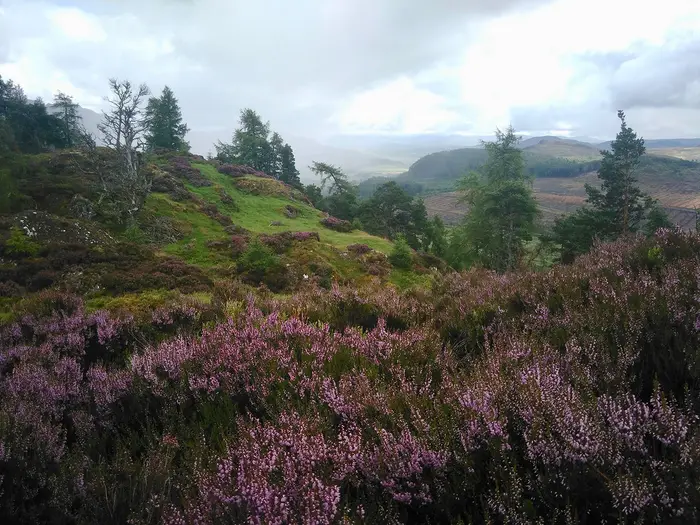
Photos from hikers
Taken on the trail by people who've reviewed East Highland Way.
East Highland Way: The Complete Guide
 i
Image by Valentina
i
Image by Valentina The East Highland Way is the quieter cross-Highland link between Fort William and Aviemore, running 132 km from Lochaber through Glen Spean, Badenoch and Strathspey to the edge of the Cairngorms. It suits experienced walkers who want a low-level but genuinely remote route rather than a waymarked National Trail.
The line keeps mostly to glens, forests, estate tracks, loch-side paths and open moorland, with highlights including Monessie Gorge, Loch Laggan, Dun da Lamh, Glen Banchor, Ruthven Barracks and the pinewoods around Rothiemurchus. It also links naturally with the West Highland Way, Great Glen Way and Speyside Way for longer coast-to-coast or north–south itineraries.
Do not mistake the modest height gain for an easy walk. The route is largely unwaymarked, accommodation is sparse in the middle, and the long Tulloch / Inverlair to Feagour section can make or break an itinerary.
The most serious practical issue is self-reliance: navigation, boggy ground, forestry diversions, limited resupply and the unbridged River Calder crossings in Glen Banchor all need proper planning. In spate after heavy rain, those crossings can become impassable.
This guide covers stages, days, accommodation, food, transport, terrain and common mistakes.
Stage-by-Stage Guide
The East Highland Way is best treated as a navigational route rather than a signed trail. The notes below are for stage planning, not turn-by-turn navigation: carry the guidebook, Harvey map or appropriate OS mapping, and a reliable GPX for every day.
Stage 1: Fort William to Spean Bridge — 19 km
The route leaves Fort William from the southern end of the High Street, close to the West Highland Way finish and Great Glen Way area, but there is no formal East Highland Way trailhead marker. The first day is a low-level departure from Lochaber, moving from the busy outdoor town into a quieter mix of tracks, minor paths and forest-edge walking.
Old Inverlochy Castle is the main early landmark, a useful historical waypoint before the route works away from Fort William towards Torlundy and on towards Spean Bridge. Expect a varied day rather than a single engineered trail: forestry and estate tracks, gravel or dirt surfaces, grassy sections and occasional rougher ground are all typical of the route as a whole.
Spean Bridge is a practical first overnight stop, with accommodation options in and around the village. Food and evening meals should be planned around what is available locally and booked ahead, especially in the main walking season. Carry enough food and water for the full day from Fort William rather than relying on finding services en route.
Public transport and road access are strongest at Fort William, which has West Highland Line rail services and coach or bus links towards Glasgow, Inverness and Fort Augustus. Spean Bridge is road-accessible, but onward public transport for section-walking should be checked before travelling.
Navigation matters from day one. The East Highland Way is unofficial and largely unwaymarked, so do not expect the consistent waymarking found on National Trails or Scotland’s better-established long-distance routes. Forestry operations can also affect line choice on parts of the route; current diversions should be checked before travelling.
Stage 2: Spean Bridge to Tulloch / Inverlair — 17 km
This stage continues east through Glen Spean, with the route becoming progressively more rural and less serviced. It is not the longest day, but it is an important positioning stage before the remote central section, so treat it as the last opportunity to organise food, accommodation and any transport support before the long haul past Loch Laggan.
The day’s notable feature is Monessie Gorge, where the River Spean cuts through a rocky defile below the West Highland railway line. The wider setting is Glen Spean, with the route travelling in the shadow of the Creag Meagaidh hills while generally keeping to low ground rather than climbing into the mountains.
Terrain is a mix of glen walking, tracks, minor paths and rougher wet ground. Conditions can be muddy or waterlogged after rain, and the route may not always be obvious on the ground. A map and GPX should be kept to hand rather than packed away.
Tulloch / Inverlair is a critical logistics point rather than a full-service trail town. Tulloch Station gives useful rail access for section walkers, but services and onward connections should be checked before travelling. Accommodation and food options are limited compared with Fort William and Spean Bridge, and many walkers need to arrange a lift, pre-booked accommodation, or a camping plan for the next stage.
Carry enough food from Spean Bridge to cover this stage and the next day’s remote section unless a definite resupply or accommodation arrangement is already in place. Do not assume shops, cafés or regular services at the end of the stage.
Stage 3: Tulloch / Inverlair to Feagour via Loch Laggan — 34 km
This is the committing central day on the standard seven-stage itinerary and the stage most likely to shape the whole trip. At about 34 km, it is long, remote and has effectively no facilities through the core of the day, so it is not a stage to start under-equipped or late.
The route passes towards Fersit and then into the Loch Laggan and Ardverikie Estate area. Loch Laggan is one of the signature sections of the East Highland Way: a long, remote loch with a broad sandy beach, backed by big Highland scenery and the estate landscape around Ardverikie.
Underfoot, expect the full range of East Highland Way conditions: estate and forestry tracks, loch-side going, gravel or dirt road sections, and potentially wet or rough ground. The walking stays relatively low, but the distance, remoteness and lack of bail-out options make it one of the hardest days in practice.
Food and water planning is essential. There are no reliable services through the main central section between Tulloch / Inverlair and the Laggan / Pattack area, so carry a full day’s food plus contingency. Any water taken from burns, lochs or hill sources should be treated or filtered.
Feagour is best treated as a route point rather than a service base. Walkers commonly solve this section by carrying camping gear, using wild camping in line with the Scottish Outdoor Access Code, or arranging pick-up and drop-off with accommodation providers on either side of the gap. Accommodation, transport and baggage arrangements for this stage should be fixed before starting the route.
Navigation must be treated seriously. The route is largely unwaymarked, and the combination of long distance, forestry, estate tracks and remote ground makes a GPS track and paper mapping strongly advisable. In poor weather or fading light, route-finding errors here can become time-consuming.
Stage 4: Feagour to Laggan — 9 km
This is the shortest stage on the standard itinerary, but it is not a disposable day: it is often used to recover from the long Loch Laggan stage, reposition after a pick-up or wild camp, and prepare for the Glen Banchor crossing that follows. The route moves from the Pattack / Feagour area towards Laggan, with the walking becoming more settled as the village is approached.
The terrain is generally lower-level glen and estate-country walking rather than high mountain ground. Depending on recent weather, expect wet, rough or muddy patches, especially away from firmer tracks.
Laggan is a key overnight and logistics point because the next stage crosses remote ground to Newtonmore. Accommodation in or near Laggan should be booked ahead, and food for the following day should be organised here or carried in from earlier stages. Do not rely on turning up and finding spare beds in the central Highlands during busy periods.
The nearby Dun da Lamh hillfort is one of the important historical highlights in this part of the route, standing on a crag above the Spey with wide views over Strathmashie and the Spey valleys. Whether included as a detour or simply used as a landmark, allow enough time and energy; the following day has more serious route-finding demands.
Public transport in this central part of the route should not be assumed. Road access and pre-arranged lifts are often more useful than trying to improvise public transport, and all arrangements should be checked before travelling.
Stage 5: Laggan to Newtonmore via Glen Banchor — 16 km
This is the wildest and most navigationally serious stage of the East Highland Way. The route crosses Glen Banchor in the Monadhliath foothills, reaching the route’s highest ground at about 390 m before dropping towards Newtonmore.
Although the height gain is modest by Highland standards, the terrain can feel much more remote than the numbers suggest. Expect grassy moorland, boggy and sometimes pathless ground, wet underfoot conditions and slower progress than on estate tracks. This is not a day to judge by distance alone.
The key hazard is the River Calder in Glen Banchor, where the route involves three unbridged crossings. These can become impassable in spate after heavy rain. River levels and recent weather should be checked before committing to the stage, and walkers should be prepared to delay, turn back or use an alternative plan if crossings are unsafe.
Navigation is also critical. In mist, rain or low cloud, the open moorland character of Glen Banchor can make line-holding difficult, especially where the ground is wet and paths fade. A map, compass and reliable GPS are essential, not optional.
There are no services across the Glen Banchor section, so carry all food and water needed for the day. Any natural water should be treated. Keep enough food and warm layers available in case the crossings or ground conditions slow progress.
Newtonmore is a major practical stop on the route, with accommodation in the village and better access to services than the preceding central stages. Public transport and section-walking arrangements from Newtonmore should be checked before travelling.
Stage 6: Newtonmore to Kincraig — 24 km
This is a longer but more settled stage, moving through Badenoch from Newtonmore towards Kingussie, Ruthven and Kincraig. Compared with the central stages, it gives more contact with villages, historic sites and established paths, though the distance still makes it a full walking day.
The route passes Kingussie and then Ruthven Barracks, one of the strongest landmarks on the whole trail. The barracks are the stark ruins of an 18th-century government infantry barracks built after the 1715 Jacobite rising and burned by the Jacobites after Culloden in 1746.
Beyond Kingussie the East Highland Way uses the Badenoch Way towards Kincraig. This is one of the few clearer, waymarked parts of the overall route, passing wetland and the Insh Marshes near Loch Insh. Even here, do not let the presence of waymarking create a false sense that the whole East Highland Way is signed.
Terrain is more varied and generally more defined than Glen Banchor, with village approaches, paths, tracks and wetland-edge walking. Mud and wet ground are still normal, especially around low-lying areas near Loch Insh and the Insh Marshes.
Newtonmore, Kingussie and Kincraig all matter for logistics. Accommodation is available in the main Badenoch settlements, but it should be booked well ahead. Food and water are easier to plan than on the central stages, but opening times and exact resupply options should be checked before travelling.
Public transport and road access are more practical through this corridor than in the remote middle of the route, especially for section walkers, but current times and connections should be checked before travelling. Kincraig is a good overnight stop before the final approach to Aviemore.
Stage 7: Kincraig to Aviemore — 17 km
The final stage carries the route from Kincraig through the forested approach to Strathspey and Aviemore. It is shorter than the previous day, but still requires normal East Highland Way navigation and weather judgement.
The route passes through or near Feshiebridge, Inshriach and Rothiemurchus, entering the Caledonian pine forest landscape on the edge of the Cairngorms. This is one of the most attractive finishes to any Scottish low-level long-distance route, with the Cairngorm plateau nearby and the route approaching Aviemore through a distinctly Highland forest setting.
Loch an Eilein and its ruined island castle lie close to this final approach, and the wider Rothiemurchus area is a major highlight. The walking is generally lower-level forest and track-based terrain rather than open mountain, but paths and junctions can still be confusing without a map or GPX.
Carry food and water for the day from Kincraig unless definite stops are planned. Aviemore has the strongest end-of-route services, with a wide range of accommodation, food and onward travel options, but beds should still be booked early in busy periods.
Aviemore is on the Highland Main Line, with rail links on the Edinburgh / Glasgow–Inverness corridor, Caledonian Sleeper services and LNER services, plus frequent buses. It is also the start of the Speyside Way, making it a natural continuation point for walkers linking long-distance routes.
For those returning to Fort William, remember that Aviemore and Fort William are on different railway lines. There is no quick direct local train between the two endpoints; return travel is normally planned via Glasgow or by bus or coach, and current timetables should be checked before travelling.
Recommended Itinerary
Standard 7-day itinerary
The most practical schedule is the commonly used 7-stage west-to-east itinerary from Fort William to Aviemore. It keeps the route manageable while accepting that the central section has one long, committing day and very limited accommodation options.
| Day | From | To | Approx. distance | Why this stage makes sense | Services/accommodation notes |
|---|---|---|---|---|---|
| 1 | Fort William | Spean Bridge | 19 km | A sensible first day out of Fort William, moving from the busy trail hub into Glen Spean without starting with an excessive distance. | Fort William has the best pre-walk services. Spean Bridge has accommodation options, but these should be booked ahead. |
| 2 | Spean Bridge | Tulloch / Inverlair | 17 km | Keeps the second day moderate before the much longer central crossing. It also positions you for the remote Loch Laggan stage. | Services and accommodation are much more limited around Tulloch / Inverlair than in the main towns. This should be checked before travelling. |
| 3 | Tulloch / Inverlair | Feagour, via Loch Laggan | 34 km | This is the key committing stage of the itinerary: long, remote and with little or no resupply. Starting from Tulloch / Inverlair gives the cleanest line through the central section. | Do not rely on facilities during the day. Feagour is only a practical overnight point if accommodation, pick-up/drop-off or a camping plan has been arranged in advance. |
| 4 | Feagour | Laggan | 9 km | A deliberately short recovery stage after the long Loch Laggan day. It also avoids pushing straight into Glen Banchor while tired. | Use this day to reset food, weather and river-crossing plans before the next remote section. Availability in and around Laggan should be checked before booking the itinerary. |
| 5 | Laggan | Newtonmore, via Glen Banchor | 16 km | Short on paper, but one of the most serious days because of rough ground, navigation and the unbridged River Calder crossings in Glen Banchor. | The River Calder crossings can become impassable in spate after rain. Newtonmore has town accommodation and is a useful point to recover after the wildest section. |
| 6 | Newtonmore | Kincraig | 24 km | A longer but more settled Badenoch stage, with Kingussie and Ruthven Barracks en route and the route picking up the waymarked Badenoch Way towards Kincraig. | Newtonmore, Kingussie and Kincraig offer more practical accommodation options than the central route, but advance booking is still strongly advised. |
| 7 | Kincraig | Aviemore | 17 km | A manageable final day through the Inshriach and Rothiemurchus area into Aviemore, with no need to rush for a very long finish. | Aviemore has the best end-of-route services and onward transport on the Highland Main Line. Accommodation should still be booked early in busy periods. |
Slower 8-day option
An 8-day schedule suits walkers who want more margin for weather, navigation, river levels and the awkward central accommodation gap. The main reason to slow the route down is not overall ascent, but the combination of rough ground, sparse services and the long Tulloch / Inverlair to Feagour section.
The most useful slower adjustment is to split the 34 km Tulloch / Inverlair to Feagour stage, either by carrying camping gear or by arranging a pick-up/drop-off with accommodation on one side of the central section. Do not assume there is a convenient serviced overnight stop at the halfway point; the exact split should be planned from current mapping and booked arrangements.
A second sensible use of an extra day is to build in a weather or river-level buffer before Glen Banchor. If heavy rain has raised the River Calder, waiting can be safer than forcing the crossings.
Faster 5–6 day option
A 6-day itinerary is possible for fit, self-sufficient walkers by combining the short Feagour to Laggan day with the Laggan to Newtonmore stage, making a longer Feagour to Newtonmore day of roughly 25 km via Glen Banchor. This removes the recovery day, so it should only be considered if river levels, weather and daylight are favourable.
A 5-day schedule is a much more demanding undertaking. One possible compression is to combine Fort William to Spean Bridge and Spean Bridge to Tulloch / Inverlair into a first day of roughly 36 km, keep the long Tulloch / Inverlair to Feagour stage at roughly 34 km, then continue with longer remaining days. This is not a good plan for most walkers, because it places two very long days before or during the route’s least forgiving section.
For any faster itinerary, accommodation and transport must be arranged before committing to the schedule, and distances should be checked against current mapping before booking.
Planning the Route
How many days to allow
Most walkers should plan the East Highland Way around the standard 7-stage schedule. That gives enough time for the rougher sections, the limited resupply and the remote central crossing without turning the route into a continuous race against daylight and accommodation logistics.
A 6-day itinerary is possible for fit, efficient walkers who are comfortable with long Highland days and carrying what they need through the no-services middle section. A slower 8-day plan gives more margin for weather, forestry diversions, tired legs and the River Calder crossings in Glen Banchor, but it only works if accommodation, camping spots or transfers can be made to fit the gaps.
The route is not best planned as a fast lightweight trail unless navigation, boggy ground and self-sufficiency are already familiar. Its low overall altitude can be misleading: the time-consuming parts are rough ground, uncertain lines, wet sections, long gaps between services and the need to make safe decisions at unbridged burns.
Natural stage breaks
Daily stages are strongly shaped by the available settlements and the awkward central section. Fort William, Spean Bridge, Newtonmore, Kingussie, Kincraig and Aviemore are the easiest places to build a conventional accommodation-based itinerary around; the middle of the route is much less straightforward.
The key planning problem is the long Tulloch / Inverlair to Feagour section via Loch Laggan, followed by the short Feagour to Laggan day. There are effectively no facilities through this central stretch, so walkers either carry camping gear, arrange pick-up/drop-off with accommodation on either side, or accept a very long day where the route allows it.
| Stage | Usual section | Approx. distance | Planning notes |
|---|---|---|---|
| 1 | Fort William to Spean Bridge | 19 km | A manageable first day with services at both ends. Useful for checking pace before the remoter ground. |
| 2 | Spean Bridge to Tulloch / Inverlair | 17 km | Leads into the sparse middle of the route. Finalise food, timing and onward arrangements before committing beyond this point. |
| 3 | Tulloch / Inverlair to Feagour via Loch Laggan | 34 km | The major logistical stage. Long, remote and with no facilities; most walkers need an early start, camping plan or arranged transfer. |
| 4 | Feagour to Laggan | 9 km | Short on paper, but often dictated by where the previous stage ends and what accommodation or transfer has been arranged. |
| 5 | Laggan to Newtonmore via Glen Banchor | 16 km | The wildest crossing, with unbridged River Calder crossings that can become impassable in spate after rain. Build in weather judgement here. |
| 6 | Newtonmore to Kincraig | 24 km | A longer settled stage, using the Badenoch Way from Kingussie towards Kincraig. Accommodation should still be booked ahead. |
| 7 | Kincraig to Aviemore | 17 km | Final approach through the Inshriach / Rothiemurchus area to Aviemore, with better end-of-route services. |
Shortening, extending and rest days
The East Highland Way is not especially easy to shorten once committed to the central section. The best places to adjust the plan are at Fort William, Spean Bridge, Tulloch / Inverlair, Laggan, Newtonmore, Kingussie, Kincraig and Aviemore, because these are the main settlement or access points named on the route.
A rest or buffer day is most useful before or after the central section, or before Glen Banchor if the weather has been wet. The River Calder crossings should not be treated as fixed obstacles that must be forced on schedule; if the burns are in spate, waiting, retreating or using a revised plan is the sensible option.
Extending the walk is straightforward in concept because the route links Fort William with Aviemore, connecting the West Highland Way / Great Glen Way area to the Speyside Way. Any extension should be planned as a separate walk with its own accommodation and transport logistics.
Section hiking
Section hiking is practical, but it needs more planning than on a fully waymarked national trail. Fort William and Aviemore are the clearest access points because both have railway stations, while Tulloch / Inverlair includes Tulloch Station on the route.
For intermediate starts and finishes, transport is not always a simple local hop, and road access does not automatically mean convenient public transport. Pick-ups, taxis, accommodation shuttles or careful bus planning may be needed, and current options should be checked before travelling.
The most sensible section-hiking split is usually to avoid being stranded in the no-facilities central part. Treat Tulloch / Inverlair to Laggan or Pattack / Feagour as a committing section unless a firm transfer, camping plan or accommodation arrangement is already in place.
Accommodation and food planning
Accommodation must be booked well ahead, especially in the smaller places and around the sparse middle of the route. The towns offer a mix of B&Bs, guest houses, hotels and hostels, but the spacing is uneven and the route does not provide a reliable village-at-the-end-of-every-day pattern.
The central section between roughly Inverlair / Tulloch and Laggan / Pattack has effectively no accommodation or facilities. Walkers using indoor accommodation commonly need a pick-up/drop-off arrangement with a B&B or other provider on either side, while self-sufficient walkers may carry camping gear.
Food planning should assume no resupply through the middle of the route. Carry enough food for the long central stretch and allow a reserve in case bad weather, slow ground or river levels delay progress.
Wild camping is possible under the Scottish Outdoor Access Code, but it is not a substitute for planning. Camp discreetly, keep group size small, avoid damage, take all litter out and be prepared for wet ground.
Navigation and route information
Navigation is one of the main planning tasks on the East Highland Way. The route is unofficial and largely unwaymarked, with only short signed sections, including some forestry re-routes and the waymarked Badenoch Way near Kingussie.
Carry dedicated route information rather than relying on occasional signs. The Harvey East Highland Way map, suitable OS mapping, a guidebook and a GPX track are all sensible tools; at least one non-electronic backup should be carried.
Forestry diversions and estate or path changes can affect the line. Current route notes and any temporary diversions should be checked before travelling, especially where the route passes through forested sections.
Weather, rivers and timing
The route stays low, but it crosses remote Highland ground where weather can still control the day. Wet, boggy and waterlogged conditions are normal, so timings should allow for slower progress than the map distance might suggest.
Glen Banchor is the main weather-sensitive section. The unbridged River Calder crossings can become impassable in spate after heavy rain, and this should be considered before leaving Laggan for Newtonmore.
Spring, summer and autumn are the normal walking seasons. In any season, long daylight is helpful for the 34 km central stage, but daylight should not be used as an excuse to underestimate navigation, river levels or fatigue.
Transport planning
Fort William and Aviemore both have railway stations, but they are on different lines. Fort William is on the West Highland Line; Aviemore is on the Highland Main Line, and there is no useful direct train between the two ends.
Point-to-point logistics therefore need to be planned in advance rather than left as a quick local return. Many walkers arrange the return via Glasgow or use bus/coach options, depending on current timetables.
Transport times, accommodation pick-ups and any luggage or transfer arrangements should be checked before booking the final itinerary. The route’s hardest logistics are not at the start or finish, but in making the middle section work safely.
Towns, Villages and Overnight Stops
Accommodation planning on the East Highland Way is not evenly spaced. Fort William, Spean Bridge, Newtonmore, Kingussie, Kincraig and Aviemore are the main service bases, while the central section around Tulloch / Inverlair, Fersit, Loch Laggan, Feagour and Laggan is much more awkward to plan.
Book accommodation well ahead, especially if walking without camping gear. The long Tulloch / Inverlair to Feagour stage and the wider no-facilities central section are the places where itineraries most often need a pick-up, drop-off, wild camp or other pre-arranged solution.
| Place | Best use for hikers | Overnight practicality |
|---|---|---|
| Fort William | Start, travel, supplies | Excellent |
| Torlundy | Early route point north-east of Fort William | Limited / check ahead |
| Spean Bridge | First main overnight stop | Good |
| Roybridge | Near-route settlement in Glen Spean | Possible only if pre-planned |
| Monessie | Route landmark near Monessie Gorge | Not a normal overnight base |
| Tulloch / Inverlair | Stage end and access point at Tulloch Station | Awkward; plan carefully |
| Fersit | Remote central route point | Not a service stop |
| Loch Laggan / Ardverikie Estate | Remote loch and estate section | Camping or pre-arranged logistics only |
| Kinloch Laggan | Route point near Loch Laggan | Check before relying on services |
| Pattack / Feagour | Common stage end after the long central day | Often needs pick-up/drop-off or camping |
| Laggan | Useful staging point before Glen Banchor | Check accommodation and food before travelling |
| Newtonmore | Main service stop after Glen Banchor | Good |
| Kingussie | Service town on the Badenoch section | Good |
| Ruthven | Historic site near Kingussie | Not an overnight base |
| Loch Insh | Route area between Kingussie and Kincraig | Check before relying on services |
| Kincraig | Final overnight before Aviemore for many 7-day itineraries | Good but book ahead |
| Feshiebridge | Route point between Kincraig and Rothiemurchus | Check before relying on services |
| Inshriach / Rothiemurchus | Forest approach to Aviemore | Not a necessary overnight stop |
| Aviemore | Finish, travel, recovery night | Excellent |
Fort William
Fort William is the western start of the route, at the southern end of the High Street near the West Highland Way finish and the Great Glen Way. There is no formal East Highland Way trailhead marker, so the first morning is more about navigating out of town than following official waymarks.
This is one of the best places on the route for accommodation, food and last-minute supplies. B&Bs, guest houses, hotels and hostels form part of the accommodation mix in the larger route towns, and Fort William is the obvious place to stay before starting.
Fort William has a railway station on the West Highland Line, with trains from Glasgow Queen Street and Caledonian Sleeper services. Buses also run to Glasgow, Inverness and Fort Augustus, but current times should be checked before travelling.
Torlundy
Torlundy sits early on the route as the walk leaves Fort William and heads into Lochaber. For most walkers it is too close to the start to be a useful overnight stop.
Do not plan around Torlundy for resupply or accommodation unless something has been booked in advance. It is better treated as an early route point rather than a service base.
Transport options here are not part of the core route logistics. This should be checked before travelling.
Spean Bridge
Spean Bridge is the first main overnight halt on the standard 7-stage itinerary, about 19 km from Fort William. It is a sensible place to stop before the route continues deeper into Glen Spean.
Accommodation is much more practical here than in the smaller route settlements that follow. Book ahead, as the next stages quickly become more committing and there is no reliable pattern of frequent services beyond this point.
Use Spean Bridge to sort food for the following day and to reassess the plan for the central section. Current shop, pub and café opening times should be checked before travelling.
Roybridge
Roybridge lies near the route in Glen Spean and may be relevant for walkers adjusting the first two days. It is not one of the standard stage ends in the 7-day itinerary, but it can matter if accommodation in Spean Bridge or Tulloch / Inverlair is unavailable.
Treat Roybridge as a possible pre-planned alternative rather than an assumed walk-up solution. Accommodation, food and transport arrangements should be checked before travelling.
Monessie
Monessie is important mainly because of Monessie Gorge, where the River Spean cuts through a rocky defile below the West Highland railway line. It is a route highlight rather than a practical overnight stop.
Do not expect Monessie to solve accommodation or resupply planning. Continue to plan the day around Spean Bridge and Tulloch / Inverlair, or around a pre-arranged pick-up.
Tulloch / Inverlair
Tulloch / Inverlair is the usual end of the second stage from Spean Bridge and the start of the long central stage towards Feagour. Tulloch Station gives this area particular value as an access or escape point, but that does not make it an easy overnight base.
The section from roughly Inverlair / Tulloch towards Laggan / Pattack has effectively no accommodation or facilities. Many walkers either arrange a pick-up and drop-off with accommodation on one side of the gap, or carry camping gear.
Do not arrive here assuming there will be food, a pub or a bed. Accommodation, train times from Tulloch Station and any onward logistics should be checked before travelling.
Fersit
Fersit lies in the remote central part of the route after Tulloch / Inverlair. It is useful for navigation and itinerary planning, but not as a dependable service stop.
There are no route-planning grounds to rely on Fersit for accommodation, food or transport. Carry what is needed for the day and have the onward plan fixed before leaving Spean Bridge or Tulloch / Inverlair.
Loch Laggan / Ardverikie Estate
Loch Laggan and the Ardverikie Estate form one of the most remote and memorable sections of the East Highland Way. The route passes through a long, low, wild-feeling loch and estate landscape rather than a chain of villages.
This is not a section with normal resupply or easy accommodation. Walkers using a 7-day schedule often face the long Tulloch / Inverlair to Feagour day here, so food, water strategy, weather and timing matter.
Wild camping is legal in Scotland under the Scottish Outdoor Access Code, but camping here still requires responsible site choice and full self-sufficiency. Any plan involving bothies or estate-side arrangements should be checked before travelling.
Kinloch Laggan
Kinloch Laggan is a useful named point around the Loch Laggan part of the route. It can help break up the mental map of the long central section, but it should not be treated as a guaranteed services hub.
Accommodation, food and transport should all be checked before relying on Kinloch Laggan. If walking without camping gear, the wider Tulloch / Inverlair to Laggan / Pattack gap needs to be solved before the trip begins.
Pattack / Feagour
Pattack / Feagour is commonly used as the end of the long central stage from Tulloch / Inverlair, around 34 km in the standard itinerary. This is one of the most important logistical points on the whole trail.
Feagour should not be assumed to have normal walker services. Many itineraries depend on a pre-arranged pick-up/drop-off, or on carrying camping equipment.
Arrive with food already carried and do not rely on finding a shop, café, pub or accommodation at the end of the day. This should be checked before travelling.
Laggan
Laggan is the next key staging point before the route crosses Glen Banchor to Newtonmore. In the standard itinerary, the Feagour to Laggan day is short, which can help after the long Loch Laggan section.
Laggan is a useful place to aim for when breaking up the central part of the route, but accommodation and food should not be left to chance. Book anything required well in advance and check current opening times before travelling.
The following stage to Newtonmore includes the Glen Banchor crossing and unbridged River Calder crossings, which can become impassable in spate after rain. Laggan is therefore a good place to reassess weather, river levels and onward options.
Strathmashie
Strathmashie lies between Laggan and Newtonmore and is relevant to the route as it moves from the Laggan area towards Badenoch. It is not a main overnight stop in the standard schedule.
Do not rely on Strathmashie for accommodation or resupply unless arrangements have been made in advance. Most walkers should treat this as part of the day’s walking towards Newtonmore.
Newtonmore
Newtonmore is the first major service stop after the remote Glen Banchor crossing. It is a very important overnight base because it follows a stage with rough ground and unbridged River Calder crossings.
Accommodation in the route towns includes B&Bs, guest houses, hotels and hostels, and Newtonmore is one of the main places where walkers can reset, dry kit and restock. Book ahead, particularly in the main walking season.
Newtonmore is also a sensible place to build flexibility into the itinerary. If rain has made Glen Banchor unsafe, plans may need to change rather than forcing the crossing.
Kingussie
Kingussie is the next main service town after Newtonmore and sits on the Badenoch section of the route. It is useful either as an overnight stop in its own right or as part of a shorter day if the itinerary is being adjusted.
The East Highland Way adopts the waymarked Badenoch Way near Kingussie towards Kincraig, making this one of the clearer sections to follow compared with the largely unwaymarked western and central parts of the route.
Accommodation and food are more realistic here than in the smaller settlements, but still book and check opening times before travelling. Kingussie is also close to Ruthven Barracks, one of the route’s main historical landmarks.
Ruthven
Ruthven is best known for Ruthven Barracks, near Kingussie. The barracks are a worthwhile landmark, but Ruthven is not a normal overnight planning point for the East Highland Way.
Use Kingussie for practical arrangements rather than trying to base a walking day around Ruthven. Food, accommodation and transport should be organised through the main nearby service towns.
Loch Insh
Loch Insh lies on the Badenoch Way section between Kingussie and Kincraig, with the route passing wetland and the Insh Marshes nearby. It is a useful landmark on the Newtonmore / Kingussie to Kincraig day.
Do not assume Loch Insh will provide food, accommodation or transport at the moment needed. Any stop here should be checked before travelling and built into the day deliberately.
Kincraig
Kincraig is the standard overnight stop before the final stage to Aviemore on a 7-day itinerary. It is the most practical base between the Badenoch Way section and the final approach through Inshriach and Rothiemurchus.
Accommodation is part of the main route-town mix, but availability can be limited and should be booked early. Current food and pub/café options should be checked before travelling, especially if arriving late after the Kingussie to Kincraig stage.
Kincraig is a good place to start the final day rested rather than pushing all the way to Aviemore from Newtonmore or Kingussie. It also keeps the last stage to Aviemore to a manageable length.
Feshiebridge
Feshiebridge lies between Kincraig and the Inshriach / Rothiemurchus approach to Aviemore. It is useful as a route point on the final stage rather than a necessary overnight stop.
Do not rely on Feshiebridge for services unless specific arrangements have been checked. Most walkers will already have stayed in Kincraig and will be heading for Aviemore.
Inshriach / Rothiemurchus
Inshriach and Rothiemurchus mark the final approach towards Aviemore, with the route passing through Caledonian pine forest in the lee of the Cairngorms. This is one of the more attractive finishing sections, but it is still part of the walking day rather than a required overnight stop.
There is no need to create an overnight here on the standard itinerary unless deliberately slowing the route down. Food, accommodation and transport should be planned around Kincraig and Aviemore instead.
Aviemore
Aviemore is the eastern finish of the East Highland Way and the southern gateway to the Cairngorms. The route ends in the Strathspey resort town, where the Speyside Way also begins.
This is one of the best places on the route for accommodation and post-walk logistics. B&Bs, guest houses, hotels and hostels are part of the accommodation mix in the main route towns, and Aviemore is the obvious place for a final night if onward travel is not immediate.
Aviemore has a railway station on the Highland Main Line, with services on the Edinburgh / Glasgow to Inverness corridor, Caledonian Sleeper services and LNER services. It also has frequent buses, but current times should be checked before travelling.
There is no useful quick direct train back to Fort William because the two endpoints are on different rail lines. Most point-to-point returns are planned via Glasgow or by bus/coach, so build that into the final day rather than assuming a simple local transfer.
Getting to the Start
The East Highland Way starts in Fort William, at the southern end of the High Street near the West Highland Way finish and the Great Glen Way. It is an unofficial route, so do not expect a formal trailhead marker or National Trail-style start point; have the first section mapped before leaving town.
By train
Fort William railway station is the most practical public-transport arrival point for the start. The town is on the West Highland Line, with services from Glasgow Queen Street, and is also served by the Caledonian Sleeper.
Build in time for onward walking logistics in Fort William: food, fuel, maps, cash and any last accommodation checks are easier here than on the early rural sections. Current train times, sleeper availability and engineering works should be checked before travelling.
A key point for end-to-end planning is that Fort William and Aviemore are on different railway lines. There is no useful direct train between the two ends of the walk, so returning to a car or repositioning by rail usually involves a much longer journey via Glasgow, or a bus/coach alternative.
By bus
Fort William has bus connections to Glasgow, Inverness and Fort Augustus. This can be useful if rail times do not suit, or if combining the East Highland Way with other Highland walking routes.
Long-distance bus and coach timetables in the Highlands can vary by season and day of week. This should be checked before travelling, especially if arriving late in the day and relying on an onward connection or a booked bed.
By car
Driving to Fort William is straightforward in principle, but less convenient for this walk than for a circular route. The East Highland Way finishes in Aviemore, and getting back to Fort William is not a quick local hop.
If leaving a vehicle in Fort William, arrange suitable long-stay parking before setting off rather than assuming it will be available on arrival. Accommodation providers may be able to advise on local options, but this should be checked before travelling.
Some walkers instead leave a vehicle at Aviemore and travel to Fort William before starting, so the car is waiting at the finish. This avoids a post-walk transfer, but still requires a planned public-transport or coach journey to the start.
From the nearest airport
There is no airport arrival directly at the trailhead. Most air arrivals will need to connect through a larger Scottish transport hub, then continue to Fort William by train or bus.
For practical planning, Glasgow is the simplest rail gateway mentioned for Fort William, via Glasgow Queen Street and the West Highland Line. Inverness is also relevant for bus links to Fort William. Airport transfer times, onward rail or bus connections and late-arrival options should be checked before booking flights.
Where to stay before starting
Fort William is the best place to stay the night before starting. It gives the easiest access to the start at the southern end of the High Street and the best chance to sort food, fuel, navigation and weather decisions before committing to the route.
Book ahead in busy walking periods. The East Highland Way has sparse services later on, and early-stage accommodation at places such as Spean Bridge and Tulloch / Inverlair should be coordinated with the first days of the itinerary rather than left until arrival.
If arriving late by train, sleeper or bus, staying in Fort William before the first walking day is strongly preferable to trying to push on immediately. The route is largely unwaymarked from the outset, and starting rested with the correct map or GPX loaded is a sensible safety margin.
Getting Home from the Finish
The East Highland Way finishes in Aviemore, a well-connected Strathspey resort town on the edge of the Cairngorms. It is much easier to leave the trail from here than from the remote middle stages, but onward travel still needs planning because Fort William and Aviemore sit on different rail lines.
If there is any risk of finishing late, book a night in Aviemore rather than relying on the last public transport of the day. Train and bus times are timetable-dependent and should be checked before travelling.
By train
Aviemore has a railway station on the Highland Main Line, with services towards Inverness and south towards Edinburgh and Glasgow. The station is also served by long-distance operators including the Caledonian Sleeper and LNER.
This is the simplest public-transport option for most walkers heading home from the finish. It is especially useful if travelling onward to Inverness, Edinburgh, Glasgow or connecting with the wider UK rail network.
Returning from Aviemore to Fort William by train is not a quick local connection. Fort William is on the West Highland Line, while Aviemore is on the Highland Main Line, so a rail journey between the two normally involves a long routing, typically via Glasgow rather than a direct cross-country hop.
Book longer-distance rail tickets in advance where possible, and leave a sensible buffer after the final walking day. The last section into Aviemore is not the hardest part of the route, but delays from weather, navigation, tiredness or earlier itinerary changes can still affect your finish time.
By bus
Aviemore has frequent bus services compared with the smaller places along the route. Buses are a practical alternative to the train for onward travel, especially where the timetable or ticket prices work better for your destination.
For a return towards Fort William, bus or coach travel may be more practical than trying to make a rail connection between the two separate railway lines. Exact routes, changes and running times vary, so check current timetables before committing to same-day travel.
If finishing on a Sunday, public holiday or in the evening, do not assume the same level of service as on a normal weekday. Build the transport plan around the actual timetable for the day you expect to arrive in Aviemore.
By car/taxi
For walkers who have left a car at Aviemore, the finish is straightforward: walk into town, collect the vehicle, and avoid the cross-Highland public-transport return to Fort William. Long-stay parking arrangements should be checked locally before leaving a vehicle for several days.
If a vehicle has been left at Fort William, getting back to it is the awkward part of the route logistics. Public transport is usually the sensible option; a taxi all the way back to Fort William would be a long inter-town transfer and should only be considered with a pre-booked fixed quote.
Local taxis in Aviemore are useful for reaching accommodation, picking up stored luggage or connecting with nearby places if tired at the end of the walk. Pre-book if arriving late, during busy holiday periods or with a group carrying large rucksacks.
From the nearest airport
For flights after the walk, plan first to travel from Aviemore by train or bus to a city with onward air connections, such as Inverness, Edinburgh or Glasgow. The best choice depends on flight time, rail or bus connections, and whether an overnight stop is needed.
Do not book a tight same-day flight after the final walking stage. The East Highland Way is remote and unwaymarked for much of its length, and earlier delays can easily push the finish later than planned. Airport transfer times and current public-transport links should be checked before travelling.
Where to stay at the finish
Aviemore is one of the best-served places on the East Highland Way, with accommodation and traveller services in town. Staying overnight at the finish is often the most comfortable option, particularly after a 6–8 day walk with sparse services in the middle stages.
An overnight stop also gives more flexibility for onward rail or bus travel the next morning. Accommodation in Aviemore can be busy in the main walking season and around holiday periods, so book ahead rather than relying on finding a room on arrival.
Which Direction Should You Walk?
The East Highland Way is normally walked west to east, from Fort William to Aviemore. That is the direction used by the standard stage order and it fits the route’s role as a link from the West Highland Way / Great Glen Way at Fort William through to the Speyside Way at Aviemore.
Reverse walking is possible, but it is less natural for most itineraries and does not remove the route’s main difficulties: sparse services, long central stages, rough ground, minimal waymarking and the unbridged River Calder crossings in Glen Banchor.
Fort William to Aviemore: the standard direction
Walking eastbound gives the clearest progression. The route leaves Fort William and Lochaber, follows Glen Spean towards Loch Laggan and the Ardverikie Estate, crosses the wilder Monadhliath fringe via Glen Banchor, then becomes more settled through Newtonmore, Kingussie, Kincraig and Rothiemurchus before finishing in Aviemore.
It also gives a strong psychological finish. Aviemore is a proper trail town with rail connections on the Highland Main Line, frequent buses, and an obvious onward link if continuing onto the Speyside Way.
The main drawback is that the longest and most awkward central day often comes early. In the common seven-stage plan, the Tulloch / Inverlair to Feagour section via Loch Laggan is around 34 km and has little practical support, so accommodation, pick-up/drop-off arrangements or camping plans need to be sorted well ahead.
Aviemore to Fort William: the reverse direction
Walking westbound can work if transport or accommodation availability makes Aviemore the more convenient start. It also delays the longest central section until later in the walk, which some fit walkers may prefer once they have settled into trail rhythm.
However, reverse direction is not simpler overall. The route is largely unwaymarked, so navigation can be just as demanding, and the Glen Banchor river crossings remain a key decision point in either direction. River levels after heavy rain should be checked before committing to that section.
A westbound finish in Fort William may appeal to walkers linking into the West Highland Way or Great Glen Way, but it does not provide a practical advantage for most East Highland Way itineraries. Fort William has rail and bus links, but the return between Aviemore and Fort William is not a quick local hop because the two towns sit on different railway lines.
Gradients, weather and accommodation flow
Direction makes little difference to the physical climbing. The East Highland Way stays relatively low, with its highest ground around Glen Banchor at about 390 m, and there is no major pass where one direction gives a clearly easier ascent.
Weather and wind are not strong enough planning factors to choose direction on this route. The more important considerations are river levels, forestry diversions, daylight, and whether the long central section can be fitted safely around accommodation or camping plans.
Accommodation flow generally favours the standard eastbound itinerary because it follows the common stage structure: Fort William, Spean Bridge, Tulloch / Inverlair, Feagour or nearby arrangements, Laggan, Newtonmore, Kincraig and Aviemore. Even then, the middle of the route has very limited facilities, so availability may ultimately decide the direction.
Recommendation
For most walkers, the best direction is Fort William to Aviemore. It is the standard and most intuitive way to walk the East Highland Way, gives the strongest scenery progression towards the Cairngorms, finishes in a well-connected trail town, and fits naturally with onward walking on the Speyside Way.
Choose the reverse only if accommodation, transport or a longer linked route makes Aviemore the more logical starting point. Either way, treat the central section and Glen Banchor crossings as the real planning constraints, not the direction of travel.
Accommodation Along the Route
Accommodation is the main logistical constraint on the East Highland Way. The route links several well-served Highland towns, but the middle of the walk has long gaps with effectively no accommodation or facilities, especially around the Tulloch / Inverlair to Laggan / Pattack section.
This is not a route to improvise as an inn-to-inn walk. Accommodation should be booked well ahead, particularly in spring, summer and autumn, and especially for Fort William, Aviemore and the smaller overnight stops where capacity is limited.
| Place | Accommodation level | Best for | Notes |
|---|---|---|---|
| Fort William | Good | Start night, resupply, transport connections | Broadest choice at the western end, with hotels, guest houses, B&Bs and hostels. Book early in the main walking season. |
| Spean Bridge | Good | Night 1 on the common 7-stage itinerary | One of the more practical early overnight stops. Useful for walkers wanting a straightforward first day from Fort William. |
| Tulloch / Inverlair | Limited / awkward | End of stage 2, transfer planning | Accommodation and services are sparse. This stop needs careful planning; many walkers need a pre-arranged pick-up, drop-off or camping plan. This should be checked before travelling. |
| Fersit / Loch Laggan / Ardverikie area | None to very limited | Camping or passing through | The long central stage has no reliable accommodation or resupply. Walkers should not depend on finding a bed en route. |
| Feagour / Pattack | None to very limited | Transfer point or camping plan | Often used as a practical split point because of the long Tulloch / Inverlair to Feagour stage, but accommodation should not be assumed. Pre-arranged collection or carrying camping gear is the safer plan. |
| Laggan | Limited | Breaking the central section before Glen Banchor | A useful overnight stop before the remote crossing to Newtonmore, but capacity is limited and advance booking is important. |
| Newtonmore | Good | Recovery night after Glen Banchor | One of the key service villages on the eastern half, with B&Bs, guest houses, hotels and hostel-style options. A sensible place to pause after the rougher central walking. |
| Kingussie | Good | Alternative or additional stop between Newtonmore and Kincraig | Useful if splitting the Newtonmore to Kincraig day or adding a shorter day. The route uses the Badenoch Way from this area towards Kincraig. |
| Kincraig | Limited to good | Final overnight before Aviemore | A practical last stop before the Cairngorms approach through Inshriach and Rothiemurchus. Book ahead, as it has less capacity than Aviemore. |
| Aviemore | Good | Finish night, onward travel, extra Cairngorms days | Strongest choice at the eastern end, with a range of accommodation and good rail and bus links. It can be busy in the main season and at weekends. |
The difficult middle section
The awkward accommodation gap is the central part of the route, roughly from Tulloch / Inverlair through Loch Laggan and towards Laggan / Pattack. The common 7-stage schedule includes a long day from Tulloch / Inverlair to Feagour via Loch Laggan, around 34 km, followed by a short day to Laggan.
For many walkers, this is the section that decides the whole accommodation strategy. The practical options are:
- carry camping gear and plan to be self-sufficient;
- arrange a pick-up and drop-off with accommodation on either side;
- use a taxi transfer where available;
- change the itinerary to avoid being stranded without a bed.
Any transfer arrangement should be made before starting the trail. Mobile reception, weather, forestry diversions and the condition of the route can all affect timings, so a vague plan to “sort something out on the day” is not suitable for this route.
Does the route work for inn-to-inn walkers?
It can work as an inn-to-inn route, but only with careful booking and at least one awkward transfer or a very long self-supported day in the middle. Fort William, Spean Bridge, Newtonmore, Kingussie, Kincraig and Aviemore are the strongest accommodation points; the weak link is the remote central section around Tulloch / Inverlair, Loch Laggan, Feagour and Pattack.
Walkers who do not want to carry camping gear should contact accommodation providers before committing to dates and ask whether pick-up or drop-off is possible. If relying on taxis, availability and operating areas should be checked before travelling.
Booking strategy
Book the smallest and most constrained stops first, not the endpoints. Laggan, Kincraig and any plan involving Tulloch / Inverlair, Feagour or Pattack should be fixed before reserving easier nights in Fort William or Aviemore.
A practical order is:
- Solve the Tulloch / Inverlair to Laggan / Pattack gap.
- Book Laggan, Newtonmore and Kincraig.
- Book Spean Bridge.
- Add Fort William and Aviemore once the walking schedule is secure.
If accommodation is unavailable at one of the smaller stops, it may be easier to add a rest day, use Kingussie as an intermediate night, or arrange a transfer than to force a long day over rough, boggy ground. The East Highland Way is unwaymarked and remote in places, so accommodation plans should leave enough margin for slow going, poor weather and navigation delays.
Camping and Wild Camping
Camping is a realistic and often useful way to walk the East Highland Way, but this is not a simple campsite-to-campsite trail. The route crosses long, quiet sections of Lochaber, Glen Spean, Loch Laggan and the Monadhliath foothills where accommodation and services are sparse or absent.
The key planning issue is the central part of the route. The section from Tulloch / Inverlair towards Loch Laggan, Pattack / Feagour and Laggan has effectively no facilities, and the usual 34 km stage from Tulloch / Inverlair to Feagour is a major commitment without a tent or pre-arranged pick-up.
Formal campsites
No reliable stage-by-stage campsite network should be assumed on the East Highland Way. If you want to use formal campsites, check availability locally before building an itinerary around them, especially outside the main towns.
The most practical places to check for formal camping or nearby pitches are the service settlements on or near the route: Fort William, Spean Bridge, Newtonmore, Kingussie, Kincraig and Aviemore. Availability, opening dates and whether walkers are accepted without a vehicle should be checked before travelling.
Do not expect campsite-style facilities in the central section around Fersit, Loch Laggan, Pattack / Feagour, Laggan approaches or Glen Banchor. This part of the route needs either full wild-camping self-sufficiency, very careful accommodation planning, or arranged transport to and from booked accommodation off-route.
Wild camping legality in Scotland
Wild camping is generally allowed in Scotland when done responsibly under the Scottish Outdoor Access Code. On the East Highland Way, that makes a tent a practical tool rather than a last resort, particularly through the long middle of the route.
Legal access does not mean camping anywhere without judgement. Much of the route passes through forestry, estate land, working glens, farmland edges, loch shores and popular access areas, so camp discreetly, keep well away from buildings, tracks, roads, enclosed fields, livestock and historic sites, and move on after one night.
Local restrictions, forestry operations, stalking activity, estate requests and temporary diversions can affect where it is appropriate to camp. This should be checked before travelling, and any local signs or instructions should be followed.
Where camping is most useful
| Route section | Camping practicality | Main cautions |
|---|---|---|
| Fort William to Spean Bridge | Usually optional | More settlement, road and forestry influence; accommodation planning may be easier than searching for a quiet pitch. |
| Spean Bridge to Tulloch / Inverlair | Useful for flexible staging | Check land use carefully and do not assume facilities at the end of the stage. |
| Tulloch / Inverlair to Loch Laggan and Pattack / Feagour | Most useful section for carrying a tent | Long, remote and with no facilities; avoid estate buildings, access tracks and conspicuous lochside spots. |
| Pattack / Feagour to Laggan | Often unnecessary as a short stage | Can be used to break the route, but check onward food and transport plans carefully. |
| Laggan to Newtonmore via Glen Banchor | Possible but committing | Rough, boggy, exposed in poor weather, and affected by unbridged River Calder crossings which can become impassable in spate. |
| Newtonmore to Kingussie, Kincraig and Aviemore | Possible but less essential | More settlements and access pressure; avoid sensitive wetland areas near Loch Insh and camp only where responsible and permitted. |
Water and pitching
Water is a major feature of the route, with rivers, burns, lochs and wet ground throughout, but do not assume all water is safe untreated. Carry a filter, purifier or other treatment method, and fill up before leaving reliable sources for forestry, estate-track or road sections.
The wet ground is a bigger camping issue than the lack of water. Expect boggy, waterlogged pitches in places, particularly on the rougher moorland and glen sections. A slightly higher, well-drained pitch is usually safer and more comfortable than a flat-looking hollow beside a burn.
Take particular care in Glen Banchor. The River Calder crossings are unbridged and can become impassable after heavy rain; do not camp on low banks, gravel bars or flood-prone ground, and do not commit to a crossing if water levels are unsafe.
Fires, waste and low-impact camping
Use a stove and treat open fires as inappropriate on this route, especially in forestry, on peat or in dry spells. Fire restrictions and local advice should be checked locally.
Leave no trace: keep groups small, pitch late and leave early, pack out all litter, food waste and sanitary products, and avoid contaminating water sources. Toileting should be well away from water, paths, buildings and grazing animals.
Historic places such as Old Inverlochy Castle and Ruthven Barracks are not camping spots. The same applies to obvious visitor areas, estate infrastructure, farmed land and the immediate surroundings of houses, bothies, tracks and car parks.
Seasonal camping concerns
The route is normally planned for spring, summer or autumn, but wet ground is normal in any of these seasons. After sustained rain, the central glens and Glen Banchor become much more serious because of boggy ground and spate-prone crossings.
Even though the East Highland Way avoids summits, the high and open ground around Glen Banchor reaches about 390 m and can feel exposed in poor weather. A tent, sleeping system and waterproof storage should be suitable for cold, wet Highland nights rather than mild lowland camping.
Food, Water and Resupply
Food planning matters on the East Highland Way because services are unevenly spaced and the middle of the route has a long gap with effectively no facilities. Do not treat this like the West Highland Way: there are no regular trail cafés, no dependable waymark-to-waymark resupply pattern, and several overnight options require advance booking or self-sufficiency.
The safest approach is to leave Fort William with more food than the first day requires, then top up wherever current services allow. Fort William and Aviemore are the most reliable places for a full shop. Spean Bridge, Newtonmore, Kingussie and Kincraig are the settlements where walkers are most likely to plan meals or resupply, but opening hours, Sunday trading and seasonal closures should be checked before travelling.
Main resupply pattern
The critical food gap is the central section from roughly Tulloch / Inverlair through Loch Laggan, Feagour / Pattack and on to Laggan. This part should be planned as a no-shop, no-café section unless a pickup, drop-off, accommodation meal or food parcel has been arranged in advance.
For a typical 7-stage itinerary, carry at least a full day’s walking food for the 34 km Tulloch / Inverlair to Feagour stage, plus an emergency meal. If camping or using a remote overnight before Laggan, carry dinner, breakfast and the next day’s lunch as well. Do not rely on being able to buy food at Feagour or Pattack.
From Newtonmore eastwards, resupply becomes easier because the route passes through or near Newtonmore, Kingussie, Kincraig and finally Aviemore. Even here, rural opening hours can be limited, especially outside peak season or on Sundays, so avoid arriving with no backup food.
Water
Tap water is best taken at accommodation, cafés, pubs or other staffed services where available. Fill bottles before leaving each overnight stop, especially before the long central day and before Glen Banchor.
Natural water is common along much of the route because the East Highland Way follows glens, rivers, burns and loch-side terrain, including Glen Spean, Loch Laggan and Glen Banchor. It should still be filtered, boiled or chemically treated before drinking, particularly below farms, forestry, estate tracks or grazing land.
The River Calder crossings in Glen Banchor are a safety issue rather than a water problem. After heavy rain they can become impassable in spate, so do not plan water stops in a way that forces a risky crossing late in the day.
How much to carry
Most walkers should start each day with enough water to walk comfortably between known settlements or accommodation, then treat natural water if topping up en route. On dry, warm or midge-heavy days, carrying extra water is sensible because stopping to filter at burns can be slower and less pleasant than planned.
Food carry depends on itinerary, but the practical minimum is lunch, snacks and an emergency ration every day. For the central section, carry all meals needed until the next confirmed resupply or booked meal. If using B&B pickup/drop-off arrangements, confirm exactly whether packed lunches, evening meals or breakfast are included before relying on them.
| Section | Food availability | Water availability | Notes |
|---|---|---|---|
| Fort William to Spean Bridge | Fort William is the best place to start with a full food carry. Spean Bridge may be used as an overnight and possible resupply point, but current services should be checked before travelling. | Fill in Fort William before setting off. Natural water may be available on the route, but should be treated. | Do not leave Fort William under-supplied if walking on a Sunday, late in the day or outside the main season. |
| Spean Bridge to Tulloch / Inverlair | Treat this as a limited-resupply day after leaving Spean Bridge. Do not assume food at Tulloch / Inverlair unless pre-arranged. | Start with enough water from Spean Bridge. Treat burns or streams if topping up. | This stage leads into the remote middle of the route, so buy or carry food for the following day before reaching Tulloch / Inverlair. |
| Tulloch / Inverlair to Feagour via Loch Laggan | Effectively no dependable food resupply on the stage. Carry the full day’s food, plus extra if camping or if pickup/meal arrangements are uncertain. | Natural water is likely along glens and around Loch Laggan, but it should be filtered or treated. | This is the long central stage, around 34 km in the standard itinerary. Start early and carry emergency food. |
| Feagour to Laggan | Do not assume food at Feagour or Pattack. Laggan is the next planned settlement, but current food options and opening times should be checked before travelling. | Carry water from the overnight stop or collect and treat natural water en route. | A short stage on paper can still be awkward if arriving hungry with no confirmed meal at the end. |
| Laggan to Newtonmore via Glen Banchor | Leave Laggan with lunch, snacks and a backup ration. Newtonmore is the next main resupply/meal stop. | Fill before leaving Laggan. Burns and the River Calder area provide natural water, but treatment is needed. | The River Calder crossings can be impassable after heavy rain; do not let low water supplies pressure a poor crossing decision. |
| Newtonmore to Kincraig via Kingussie and Loch Insh | Food is more available in the Badenoch settlements, especially Newtonmore and Kingussie, but do not rely on rural outlets without checking hours. | Tap water can be planned around settlements and accommodation. Natural water near wetlands, lochs and farmland should be treated. | This is a long day in the standard itinerary, so carry lunch even if planning a café or pub stop. |
| Kincraig to Aviemore | Kincraig may provide limited food depending on current services; Aviemore is the reliable end-point resupply town. | Fill at Kincraig or accommodation before the final stage. Treat natural water through Inshriach and Rothiemurchus if needed. | The finish in Aviemore makes this the least critical food-carry day, but carry snacks and water for the full walk. |
Terrain, Conditions and Difficulty in Practice
The East Highland Way is not difficult because of altitude. It stays mostly in glens, forests and low moorland, with a high point around Glen Banchor at about 390 m, and it avoids the major summits of Lochaber, the Monadhliath and the Cairngorms.
In practice, the challenge is the combination of distance, rough wet ground, sparse facilities and limited waymarking. A fit hillwalker will usually find the gradients manageable, but a walker expecting a signed, surfaced trail will find several sections slow and committing.
Underfoot: tracks, paths, bog and short road sections
Much of the route uses forestry and estate tracks, gravel roads, dirt roads and loch-side paths. These sections can make for steady progress, especially through the more managed forest and estate areas.
The easier going is broken by rougher ground: grassy moorland, muddy trods, waterlogged ground and some single-track footpath. Wet feet are a normal possibility rather than an exception, particularly after rain and on the more remote central sections.
There are a few short stretches of road walking. These are not the defining character of the route, but they still require care, particularly where verges are limited or traffic is moving quickly. The main physical wear comes less from road miles and more from long days on uneven, wet ground.
The harder sections in practice
The most committing part of the route is the central section between Tulloch / Inverlair and the Laggan / Pattack area. The common stage from Tulloch / Inverlair to Feagour is around 34 km, with little or no resupply or accommodation on the way. This is where a moderate route can become a serious long day, especially with a full pack or in poor weather.
Glen Banchor, between Laggan and Newtonmore, is the other key section to treat with respect. It is the highest and wildest crossing on the route and includes rough moorland ground plus three unbridged River Calder crossings. These crossings can become impassable in spate after heavy rain, and they should not be forced.
If the River Calder is high, the safest decision may be to wait, turn back or change plans. River levels, weather and any current access information should be checked before travelling.
Navigation and waymarking
The East Highland Way is an unofficial route and is largely unwaymarked. Only short sections are signed, including some forestry re-routes and the Badenoch Way near Kingussie.
This affects difficulty as much as the terrain does. On clear estate tracks the line may feel obvious, but in forestry, on moorland, around diversions and across rougher ground, navigation can quickly become the main task. A Harvey East Highland Way map, relevant OS mapping, the guidebook and a GPS track are sensible planning tools rather than optional extras.
Do not rely on following waymarks from Fort William to Aviemore. The route needs active navigation throughout, especially in poor visibility, rain or low cloud.
Climbing, descending and exposure
The total ascent is modest for a Highland through-walk, at about 1,600 m over the full route. There are no major summit ascents and no sustained high-level ridge sections.
That makes the route less exposed than many Scottish hill routes, but it does not make it sheltered. Open glens, loch-side sections and moorland crossings can feel remote and weather-beaten, with limited escape options in the middle of the route.
Steep or technical scrambling is not a normal feature of the East Highland Way. The walking difficulty comes from navigation, rough ground, wet conditions, river crossings and long gaps between services rather than from hands-on rock terrain.
Stage-by-stage terrain character
| Section | Terrain character | Main practical difficulty |
|---|---|---|
| Fort William to Spean Bridge | Mixed low-level walking out of Fort William, with tracks, paths and some road or settlement-edge walking | Settling into navigation on an unofficial route rather than following continuous waymarks |
| Spean Bridge to Tulloch / Inverlair | Glen Spean country with tracks, paths and rougher sections around remote ground | Increasing remoteness and fewer services as the route moves east |
| Tulloch / Inverlair to Feagour via Loch Laggan | Long central stage with forest, estate and loch-side walking, plus remote ground with no meaningful facilities | Distance, commitment and the need to carry enough food, water and bad-weather clothing |
| Feagour to Laggan | Shorter day by comparison, with lower-level estate and glen walking | Often used as recovery after the long central stage, but still requires attention to route-finding |
| Laggan to Newtonmore via Glen Banchor | Rough, high-feeling moorland and glen terrain, reaching the route’s highest ground | Unbridged River Calder crossings, boggy ground and exposure to weather |
| Newtonmore to Kincraig | Badenoch and Strathspey walking, including the waymarked Badenoch Way near Kingussie and ground near Loch Insh | Longer distance, but generally less isolated than the central section |
| Kincraig to Aviemore | Forest and strath walking through the Inshriach / Rothiemurchus approach towards Aviemore | Navigation through forest and staying alert near the end of the route when fatigue can lead to mistakes |
Seasonal conditions
The normal walking season is spring, summer and autumn. Even then, the route should be planned as a wet-ground Highland walk, not as a dry trail. Rain can quickly change the feel of the route, especially on boggy moorland and at the Glen Banchor crossings.
In spring and autumn, shorter daylight and colder weather make the long central stage more committing. In summer, long daylight helps with the bigger days, but wet ground and river levels still depend on recent weather rather than the calendar.
Winter conditions are outside the usual scope for this route. Snow, ice, short daylight and difficult navigation would make the unwaymarked and remote sections significantly more serious.
What makes it easier or harder
The route feels easier when it is split into sensible stages, accommodation or pick-ups are arranged for the sparse central section, and walkers carry reliable mapping with a GPX track. Dry weather also makes a major difference, particularly for progress over boggy ground and for the Glen Banchor crossings.
It becomes harder with a heavy camping pack, poor visibility, forestry diversions, wet weather, high rivers or any delay on the long Tulloch / Inverlair to Feagour stage. The East Highland Way is therefore best treated as a self-sufficient Highland crossing, not simply as a low-level alternative to the better-waymarked national trails.
Weather and Best Time to Walk
The East Highland Way is best treated as a three-season walk: spring, summer and autumn. Although it is not a high-mountain route, it crosses remote Highland glens, forestry, moorland and boggy ground, with long gaps between services and some largely pathless sections. Weather affects not just comfort, but navigation, river crossings and whether a planned stage is sensible.
The most practical period is generally from late spring through early autumn, when daylight is more forgiving and accommodation is more likely to be operating. The least suitable period is winter, when short days, cold weather, snow or ice, poor visibility and high water levels can turn a moderate low-level route into a committing expedition.
Seasonal conditions
| Season | What to expect | Planning implications |
|---|---|---|
| Spring | Often a good walking season, but wet ground is still normal and cold weather can occur in the glens and on exposed moorland. | Allow flexibility around Glen Banchor and the River Calder crossings. Carry full waterproofs and warm layers even if the forecast looks settled. |
| Summer | Long daylight is a major advantage, especially for the long central stage between Tulloch / Inverlair and Feagour via Loch Laggan. Rain, wind and poor visibility are still possible. | Book accommodation well ahead, especially in Fort William, Spean Bridge, Newtonmore, Kingussie, Kincraig and Aviemore. Carry enough food for the central no-services section. In warm, still Highland conditions, biting insects and ticks can be a nuisance, so pack repellent and check for ticks after walking. |
| Autumn | Cooler conditions can be excellent for walking, but daylight shortens quickly and wet, boggy ground becomes more limiting after repeated rain. | Start early on longer days and avoid underestimating the 24 km Newtonmore to Kincraig stage and the remote Laggan to Newtonmore crossing. Check accommodation and transport before committing to an itinerary. |
| Winter | Not recommended as a standard through-hike. The route is largely unwaymarked, remote in the middle, and includes unbridged river crossings. | Only suitable for very experienced, self-sufficient walkers with winter navigation ability, flexible plans and the judgement to turn back. This should be checked before travelling. |
Rain, bog and river crossings
Wet, rough and waterlogged ground is normal on the East Highland Way. Forestry and estate tracks can be straightforward in poor weather, but the rougher moorland sections become slower and more tiring after rain.
The key weather-related hazard is Glen Banchor between Laggan and Newtonmore. The route crosses the River Calder three times, and these unbridged crossings can become impassable in spate after heavy rain. If the burns are high, do not rely on being able to force the route; build enough flexibility into the itinerary to wait, divert or abandon the stage.
The long central section from Tulloch / Inverlair towards Feagour via Loch Laggan also needs settled planning. It has little or no resupply and is a long, committing day for most walkers, so poor weather, slow ground or navigation errors can have a bigger impact than the distance alone suggests.
Wind, fog and navigation
The East Highland Way stays low, with the highest ground around Glen Banchor at about 390 m, but it should not be treated as a waymarked valley stroll. Much of the route is unofficial and unwaymarked, and poor visibility can make forestry junctions, moorland lines and estate-track choices easy to miss.
Mist, low cloud and heavy rain are particularly awkward on the rougher and more open sections. Carry the guidebook or dedicated map, plus GPS or a reliable offline mapping setup, and know how to navigate without relying solely on phone signal.
Daylight and stage timing
Long daylight is one of the strongest arguments for walking the route in late spring or summer. It gives more margin for the 34 km Tulloch / Inverlair to Feagour stage, rough going around Loch Laggan, and any delays at river crossings or forestry diversions.
In autumn and winter, shorter days make the standard seven-stage itinerary less forgiving. Early starts are important, and slower walkers should consider adding time rather than trying to finish remote sections in fading light.
Accommodation and seasonal availability
Accommodation is sparse and unevenly spaced, with the main options in towns and villages such as Fort William, Spean Bridge, Newtonmore, Kingussie, Kincraig and Aviemore. The central section has effectively no accommodation or facilities, so a pick-up/drop-off, bothy plan or camping setup may be needed.
In the main walking season, popular places can book out. Outside the main season, availability can reduce and some services may be limited. Accommodation, transport, forestry diversions and river conditions should all be checked before travelling.
Safety Notes
Emergency help and mobile signal
In an emergency in the UK, call 999 or 112 and ask for Police, then Mountain Rescue if the incident is on the hill or in remote country. Give a grid reference if possible; a paper map, GPS app or dedicated GPS unit is important because place names alone may not be precise enough.
Do not plan the East Highland Way around having continuous mobile signal. The route has long, quiet sections through glens, forestry and open moorland, especially between Tulloch / Inverlair, Loch Laggan, Feagour, Laggan and Glen Banchor, where help may be some distance away. Carry a charged phone, a power bank and offline mapping.
Navigation is a safety issue here
The East Highland Way is an unofficial and largely unwaymarked route. Only short sections are signed, including parts of forestry re-routes and the Badenoch Way near Kingussie, so walkers should not rely on waymarks to stay on course.
Carry the dedicated route map or appropriate OS mapping, plus a compass and a downloaded GPX or offline route line. This matters most in forestry, on rough moorland, around Loch Laggan and on the Glen Banchor crossing, where paths can be indistinct, boggy or absent.
Remote central stages
The most committing part of the walk is the middle of the route, particularly the long section around Tulloch / Inverlair to Feagour via Loch Laggan, and the onward approach towards Laggan. Facilities and accommodation are sparse here, and a mistake with food, daylight, accommodation or pick-up arrangements can quickly become a safety problem.
Start these days early, carry enough food, and know the next realistic stopping point before leaving. If using accommodation pick-ups, drop-offs or baggage arrangements, check the details before setting off.
River crossings and wet ground
Wet, rough and waterlogged ground is normal on this route. Waterproof footwear, gaiters and poles can make the boggier sections safer and less tiring.
The key water hazard is Glen Banchor, between Laggan and Newtonmore, where the route has three unbridged River Calder crossings. These crossings can become impassable in spate after heavy rain. Do not attempt to force a crossing if the water is fast, rising, opaque or above a safe wading depth; wait, turn back or use an alternative plan.
Burns and drainage channels can also be awkward after prolonged rain. Treat drinking water if taking it from natural sources, and do not assume every burn will be safe or accessible in poor conditions.
Weather, exposure and temperature
Although the route avoids high summits, it still crosses exposed Highland ground. Glen Banchor, open moorland sections and long forest-road days can be hard in wind, rain, low cloud or sudden cold.
Carry full waterproofs, warm layers, hat and gloves outside high summer, and enough spare clothing to cope with a slow day or a navigation delay. In warm weather, exposed tracks and long stages can also become draining, so carry enough water and manage pace early in the day.
Road walking and tracks
The East Highland Way includes a few short stretches of road walking as well as estate tracks, forestry roads and gravel roads. On roads, walk on the side that gives the best visibility, take extra care on bends and in poor light, and use a headtorch or reflective detail if finishing late.
Estate and forestry tracks may have vehicles even where they feel remote. Step aside early, keep gates as found, and do not block access points.
Livestock, deer and rural access
Where the route passes through grazing land or estate ground, give livestock plenty of space and avoid getting between animals and their young. Dogs should be kept under close control, especially near livestock, ground-nesting birds and deer.
Use gates and established access points where available. The Scottish Outdoor Access Code supports responsible access, but it also depends on avoiding damage, disturbance and interference with estate or farm work.
Solo walking
This is not a beginner-friendly solo trail. Experienced solo walkers should be comfortable with poor weather, rough ground, river decisions and unwaymarked navigation.
Leave a route plan with someone reliable, including intended overnight stops and any pick-up points. Check in when possible, but do not rely on being able to send messages from the remoter sections.
Check before setting off each day
Before leaving each morning, check:
- The weather forecast for the full day, not just the start point.
- River conditions if heading for Glen Banchor or after heavy rain.
- Current forestry diversions or estate access notices where relevant. This should be checked before travelling.
- That offline maps, GPX and phone battery are ready.
- Food and water for the whole stage, especially in the central no-services section.
- Accommodation, pick-up/drop-off or onward transport arrangements.
- Daylight, expected pace and a realistic bad-weather fallback plan.
Gear Recommendations
The East Highland Way needs gear for wet Highland glens rather than high summits. The route stays relatively low, but it is largely unwaymarked, often boggy, and has long gaps with no services, so lightweight hillwalking kit must still be robust enough for rough ground, poor visibility and delayed finishes.
Footwear
Choose footwear for wet, uneven ground rather than speed on smooth paths. Waterproof boots or sturdy trail shoes with aggressive grip are more suitable than road-style walking shoes, especially for the boggy and pathless sections and the Glen Banchor crossing.
Boots give more protection on saturated moorland, forestry tracks and rough estate ground. Trail shoes can work for experienced walkers who are used to wet feet and moving efficiently, but they should have reliable grip and dry quickly.
Gaiters are useful on this route. They will not keep feet dry in deep bog or burn crossings, but they help with wet grass, mud and heather, and reduce the amount of grit entering footwear.
Waterproofs and insulation
Carry full waterproofs every day: jacket and overtrousers. The route crosses open glen and moorland sections where shelter is limited, and a wet day can become serious if combined with wind, slow going or a navigation delay.
A warm mid-layer should be packed even in summer. The high point is modest, but Glen Banchor and the central sections can feel exposed, and walkers may need to stop for navigation, river assessment or a long break between settlements.
A hat and gloves are sensible outside high summer, and still worth considering for spring and autumn trips. Spare dry socks are particularly useful because wet ground is normal rather than exceptional.
Navigation kit
Navigation is not optional on the East Highland Way. It is an unofficial route with minimal waymarking, apart from short signed sections and the Badenoch Way near Kingussie.
Carry a proper map and know how to use it. The dedicated Harvey East Highland Way map is the most route-specific option, while OS mapping also covers the line of the walk. A guidebook or detailed route notes are strongly recommended because the route can be ambiguous where tracks, forestry routes and pathless ground meet.
A phone with offline mapping and the GPX track is useful, but it should not be the only navigation tool. Carry a compass, keep paper mapping accessible in poor weather, and bring a power bank large enough for several days of navigation, photos and emergency use.
Before setting out, check for current forestry diversions and route changes. This is especially important where the route uses forest roads and estate tracks, as temporary closures can alter the practical line on the ground.
Water and food carry
Do not plan the East Highland Way like a village-to-village trail with regular cafés and shops. The central section has little or no resupply, and the long Tulloch / Inverlair to Feagour stage is especially committing.
Carry enough water capacity for a full day between reliable services, with the ability to carry extra in warm weather or when camping. Natural water may be encountered in the Highlands, but treatment is sensible if drinking from burns or lochs.
Food planning matters. Inn-to-inn walkers should still carry a substantial lunch, high-energy snacks and emergency food each day, because there are long stretches where there is nowhere to buy anything. Campers need enough food for the no-facilities central section and should not rely on finding supplies between small settlements.
River crossings and trekking poles
Glen Banchor is the main place where crossing conditions affect gear choice. The River Calder crossings are unbridged and can become impassable in spate after rain.
Trekking poles are strongly recommended for this section. They help with balance on boggy ground, rough tussocks and burn crossings, and they reduce fatigue on long track-based days.
Do not carry dedicated river-crossing shoes unless already part of a personal system; they add bulk and may not be worth it for most walkers. More important is secure footwear, poles, waterproof packing inside the rucksack, and a willingness to wait or turn back if water levels are unsafe.
Camping gear
Camping gear is relevant on the East Highland Way because accommodation is sparse and unevenly spaced, and the central section has effectively no facilities. Wild camping is permitted under the Scottish Outdoor Access Code, but camping kit should be chosen for damp ground and changeable weather.
A lightweight tent with a reliable waterproof floor, a warm sleeping bag, an insulated mat and dry bags for clothing are the key items. A stove is useful where there are no evening meal options, especially around the central stages.
Campers should keep pack weight under control. The route is not mountainous, but boggy ground and long days become much harder with an overloaded rucksack.
Power, safety and phone use
A power bank is strongly recommended for all walkers, not only campers. Phone batteries drain quickly when used for GPS tracking, offline maps and photos, and charging opportunities may be limited between overnight stops.
Keep the phone protected from rain and store backup navigation separately. A small first-aid kit, blister treatment and an emergency layer should be carried even by fast walkers, because parts of the route are remote and help may not be close at hand.
Sun, insects and seasonal extras
Sun protection is still worth packing, especially for exposed track and moorland sections in spring and summer. Bring sunglasses, sun cream and a cap or brimmed hat if the forecast is settled.
In summer, insect repellent and a midge head net can make camps and still evenings more tolerable. Tick checks are sensible after walking through long grass, woodland edges and rough vegetation.
Spring and autumn walkers should add warmer gloves, a warmer hat and a more conservative insulation layer. Shorter daylight also means a headtorch should be carried, even when planning to finish each stage before dark.
Gear approach by hiking style
| Hiking style | Route-specific gear priorities |
|---|---|
| Inn-to-inn walkers | Keep the pack moderate, but do not strip out safety kit. Carry waterproofs, warm layer, map, compass, offline GPX, power bank, full-day food and enough water for long gaps between services. |
| Campers | Add a reliable tent, warm sleep system, stove, extra food capacity and dry bags. Plan for wet ground and limited resupply, particularly through the central section between Tulloch / Inverlair, Loch Laggan, Feagour and Laggan. |
| Fast or section hikers | Lightweight kit is possible, but navigation and weather protection remain essential. Do not rely on waymarking, and carry enough food, water and battery power for delays, diversions or slow progress on boggy ground. |
Budget and Costs
Costs on the East Highland Way are driven less by distance than by logistics. Fort William, Spean Bridge, Newtonmore, Kingussie, Kincraig and Aviemore have the best accommodation choice, but the central section is sparse and unevenly spaced, with effectively no accommodation or facilities between roughly Inverlair/Tulloch and Laggan/Pattack.
All budgeting should be done in GBP (£). Current accommodation, taxi, rail, bus and package prices should be checked before booking, especially in summer and during busy Highland holiday periods.
Main cost factors
| Cost area | What to budget for |
|---|---|
| Accommodation | B&Bs, guest houses, hotels and hostels in the larger settlements. Book well ahead because options are limited outside the main towns. |
| Food | Meals in Fort William, Spean Bridge, Newtonmore, Kingussie, Kincraig and Aviemore where available, plus packed food for the long low-service middle of the route. |
| Transport | Getting to Fort William and away from Aviemore, plus the awkward point-to-point return because the two towns are on different rail lines. |
| Local transfers | Possible taxi or B&B pick-up/drop-off arrangements around the central section, particularly if not camping. This should be checked before travelling. |
| Camping | Wild camping is legal in Scotland under the Scottish Outdoor Access Code, but it shifts cost into carrying camping gear and extra food rather than paying for beds. Campsite availability should be checked before travelling. |
| Maps and navigation | A proper map/guidebook or GPX setup is a real cost here, not an optional extra, because the route is unofficial and largely unwaymarked. |
Budget approach
The lowest-cost way to walk the East Highland Way is to carry camping gear, use wild camping where appropriate, stay in hostels or cheaper rooms when available, and buy food from the larger settlements rather than relying on pub or hotel meals every night.
This approach gives the most flexibility through the central section between Tulloch/Inverlair, Loch Laggan, Pattack/Feagour and Laggan, where accommodation and food options are limited. The trade-off is a heavier pack, more self-sufficiency and the need to manage wet ground, rough camping conditions and long food carries.
A budget walker should still allow money for transport, maps, occasional indoor accommodation and possible taxis if river levels, weather or accommodation gaps force a change of plan. Do not plan this route on the assumption that a cheap bed, shop or meal will appear at the end of every stage.
Mid-range approach
A typical mid-range plan uses B&Bs, guest houses, hotels or hostels in the main overnight stops, with packed lunches carried each day. This is the most comfortable practical option for many walkers, but it needs early booking because the route passes through small Highland communities with limited beds.
The main budgeting issue is the long central gap. Walkers not carrying camping gear commonly need a pick-up/drop-off arrangement with accommodation on either side, or a taxi-style transfer to make the Tulloch/Inverlair to Feagour/Laggan section workable. Availability and prices for this should be checked before travelling.
Food costs also rise on this approach because evening meals may depend on whatever is available in small settlements, accommodation dining, pubs or hotels. Carry emergency food for at least the remote middle stages rather than budgeting as though every stop has full services.
Comfortable approach
A more comfortable East Highland Way budget means booking private rooms throughout, using taxis or accommodation transfers to avoid awkward accommodation gaps, eating out where possible, and allowing contingency funds for weather-related changes.
This is the least stressful way to manage the uneven spacing of services, but it is not simply a matter of paying more. Some stretches have very few practical options at any price, so early booking and direct communication with accommodation providers is essential.
A comfortable budget should also include flexibility at Newtonmore, Kingussie, Kincraig or Aviemore if the River Calder crossings in Glen Banchor are unsafe in spate and the itinerary needs to change.
Transport costs
Both ends of the East Highland Way are rail-served: Fort William is on the West Highland Line, while Aviemore is on the Highland Main Line. They are on different lines, so there is no simple local train hop between the start and finish.
Most walkers should budget for a longer point-to-point travel plan, commonly involving travel via Glasgow or by bus/coach. Train and bus fares vary heavily by date, booking time and route, so current prices should be checked before committing to accommodation dates.
Local taxi costs can become significant if used for the central section or for contingency changes. This is especially relevant around Tulloch/Inverlair, Loch Laggan, Pattack/Feagour, Laggan and Newtonmore, where the route is remote and public transport cannot be assumed to solve a missed stage or weather problem.
Luggage transfer and packages
Do not assume luggage transfer will be available in the same way as on more established, waymarked National Trails. The East Highland Way is unofficial, largely unwaymarked and has awkward accommodation gaps, so baggage movement needs to be checked directly before booking.
Guided or self-guided package availability can change and should be checked before travelling. Any package should be assessed carefully for how it handles the long central section, the lack of services, and the unbridged River Calder crossings in Glen Banchor.
Where to save money safely
The safest savings are usually made by booking transport early, mixing indoor accommodation with camping, carrying lunches from larger settlements, and avoiding unnecessary taxi transfers through careful stage planning.
Do not save money by skipping proper navigation tools, carrying too little food through the central section, or relying on unconfirmed accommodation. On this route, poor logistics can become more expensive than a better-planned itinerary.
Luggage Transfer, Guided Tours and Support Services
The East Highland Way needs more advance planning than better-supported Scottish trails. It is unofficial, largely unwaymarked and has a thin accommodation pattern, so support services are useful for reducing pack weight and bridging awkward gaps — but they do not remove the need for navigation, bad-weather judgement and self-reliance.
Luggage transfer
Do not assume there will be a regular baggage-transfer network at every overnight stop. The route passes through well-served towns at either end — Fort William and Aviemore — and has accommodation hubs such as Spean Bridge, Newtonmore, Kingussie and Kincraig, but the central section is much more awkward.
The key problem is the stretch around Tulloch / Inverlair, Loch Laggan, Feagour / Pattack and Laggan. Accommodation and facilities are sparse, and the long Tulloch / Inverlair to Feagour stage is commonly the hardest section to make work with normal lodging and baggage logistics.
If using luggage transfer, check all of the following before booking:
- whether the operator covers the East Highland Way specifically, not just Fort William or Aviemore;
- whether they will collect from and deliver to the exact accommodation booked;
- whether they can handle outlying stops such as Tulloch / Inverlair, Feagour / Pattack or Laggan;
- cut-off times for bag collection and delivery;
- limits on bag weight, fuel canisters, food parcels and valuables;
- what happens if a stage is altered because of weather, forestry diversions or high river levels.
Luggage transfer suits walkers staying in booked B&Bs, guest houses, hotels or hostels. It is less useful if wild camping or using bothies, because there may be no secure, staffed delivery point. In that case, a full backpack or a pre-arranged road-access rendezvous is usually more realistic.
Self-guided walking packages
A self-guided package can be a practical option on this route, especially for walkers who want accommodation, luggage movement and some transport logistics handled in one booking. Packages typically include nightly accommodation, baggage transfer between lodgings and route information, though inclusions vary and should be checked before booking.
The main value is not luxury; it is logistics. The East Highland Way has several places where accommodation spacing does not match neat walking days, and a package may include taxi transfers or pick-up/drop-off arrangements to make the central stages workable.
Before paying a deposit, ask exactly how the itinerary deals with:
- the long Tulloch / Inverlair to Feagour section;
- the lack of facilities between Inverlair / Tulloch and Laggan / Pattack;
- the Glen Banchor stage between Laggan and Newtonmore;
- the unbridged River Calder crossings, which can become impassable in spate;
- route notes and GPX support on an unwaymarked trail;
- rest days or shortening options if weather or river levels cause a delay.
A self-guided package is not a substitute for carrying a map, knowing the route and being able to navigate. The East Highland Way is not waymarked like a National Trail, and there are rough, boggy and sometimes pathless sections where route-finding remains the walker’s responsibility.
Guided walking options
Guided support can make sense for groups or less confident navigators, particularly on the rougher central sections and in Glen Banchor. It is most useful where the route becomes remote, accommodation is awkward and river crossings may affect the day’s plan.
If booking a guide, make sure the arrangement is designed for the East Highland Way rather than a generic Highland walking day. The guide should be comfortable with long-distance route logistics, low-level moorland navigation, wet ground and decisions around unbridged crossings.
For experienced walkers, a full guided trip is usually unnecessary. The route is physically moderate rather than mountainous, but it is committing because of remoteness, sparse services and limited waymarking. Strong independent walkers generally need good maps, GPX, accommodation planning and sensible contingency time more than continuous guiding.
Taxi transfers and accommodation pick-ups
Taxi transfers and accommodation pick-ups are often the most important support service on the East Highland Way. They are especially useful where the trail and the nearest practical accommodation do not line up neatly.
The places most likely to need careful transport planning are Tulloch / Inverlair, Feagour / Pattack and Laggan. Some walkers use pick-ups or drop-offs either side of the no-facilities central section instead of carrying camping gear, but this must be arranged directly and well in advance.
Taxis can also help if a stage has to be changed because of high water in Glen Banchor, poor weather, fatigue or a forestry diversion. Mobile signal and availability should not be relied on at short notice, so any critical transfer should be booked before starting the walk.
When arranging a transfer, agree:
- the exact pick-up point using a mapped place name or grid reference where appropriate;
- whether the vehicle can reach the road-end or estate access point being used;
- a realistic pick-up time, with a margin for slow boggy ground;
- what to do if there is no mobile signal;
- payment method and cancellation terms.
What to book ahead
Accommodation should be booked first, because luggage and taxi plans depend on where each night is spent. This is particularly important in the middle of the route, where there may be little flexibility.
After accommodation is fixed, arrange luggage transfer or taxi support for any non-standard stages. Confirm current prices, baggage limits and pick-up details before travelling, as availability and terms can change seasonally.
Even with support services in place, carry enough food, waterproof clothing, navigation tools and emergency margin for a long Highland day. On this route, support reduces logistical strain; it does not turn the East Highland Way into a fully serviced or waymarked trail.
Shorter Hikes and Best Sections
The East Highland Way can be broken into useful shorter sections, but it is not an ideal route for casual half-day walking. Much of it is unwaymarked, public transport is uneven, and the middle of the route has long gaps with no facilities. For any partial itinerary, carry the same mapping and navigation tools as for the full trail.
Best day walk: Kincraig to Aviemore
| Start | End | Approx. distance | Best for |
|---|---|---|---|
| Kincraig | Aviemore | 17 km | A manageable final-stage sample with forest, Cairngorms approach and services at the finish |
This is the cleanest one-day taste of the East Highland Way. It gives a strong sense of the route’s eastern character, passing through the Inshriach and Rothiemurchus area on the approach to Aviemore, with ancient Caledonian pine forest and the Cairngorms close by.
It is also one of the more practical sections because Aviemore has a railway station and frequent buses. Return transport to or from Kincraig should be checked before travelling, especially if relying on same-day public transport.
Best weekend section: Newtonmore to Aviemore
| Start | End | Approx. distance | Suggested split | Best for |
|---|---|---|---|---|
| Newtonmore | Aviemore | 41 km | Newtonmore–Kincraig, then Kincraig–Aviemore | Villages, Badenoch scenery and a satisfying two-day finish |
This is the strongest two-day section for walkers who want scenery without committing to the roughest central part of the route. It includes Newtonmore, Kingussie, Ruthven Barracks, Loch Insh, Kincraig, Feshiebridge and the forested approach through Inshriach and Rothiemurchus.
The route also adopts the waymarked Badenoch Way from Kingussie towards Kincraig, making this part less ambiguous than many earlier sections. It still should not be treated as a fully waymarked trail; map, compass or GPS navigation remain necessary.
Aviemore is the easiest transport anchor at the eastern end. Transport to Newtonmore, and any return link between Newtonmore and Aviemore, should be checked before travelling.
Best 3-day section: Laggan to Aviemore
| Start | End | Approx. distance | Suggested split | Best for |
|---|---|---|---|---|
| Laggan | Aviemore | 57 km | Laggan–Newtonmore, Newtonmore–Kincraig, Kincraig–Aviemore | A compact version of the wild-to-settled eastern half |
This is the best short itinerary for experienced walkers who want a serious East Highland Way experience rather than just a scenic day out. It begins with Glen Banchor, the route’s highest and wildest crossing, then moves into the more settled Badenoch and Strathspey stages.
The main caution is the Laggan to Newtonmore stage. Glen Banchor involves rough, boggy ground and three unbridged River Calder crossings, which can become impassable in spate after rain. This section should only be planned with a flexible weather window.
Aviemore gives the cleanest finish by public transport. Access to Laggan is less straightforward and should be checked before travelling; many walkers will need a drop-off, pick-up or pre-arranged accommodation transfer.
Best section for scenery: Tulloch / Inverlair to Feagour via Loch Laggan
| Start | End | Approx. distance | Best for |
|---|---|---|---|
| Tulloch / Inverlair | Feagour | 34 km | Remote loch scenery, Ardverikie Estate and a committing Highland day |
This is the standout section for remote glen-and-loch scenery. It crosses the long, isolated middle of the route by Loch Laggan and the Ardverikie Estate, with the Creag Meagaidh hills nearby and very little in the way of services.
It is also the most awkward short section to turn into a simple day walk. The distance is long, the terrain can be wet and rough, and the central part of the East Highland Way has effectively no accommodation or facilities. Most walkers tackling this as a standalone section will need camping gear or a pre-arranged pick-up and drop-off.
Tulloch Station gives one possible transport anchor at the western end, but timetables and onward logistics should be checked before travelling. Transport from Feagour or nearby Pattack should not be assumed.
Best section for beginners: Kincraig to Aviemore
| Start | End | Approx. distance | Best for |
|---|---|---|---|
| Kincraig | Aviemore | 17 km | First-time East Highland Way walkers with basic navigation skills |
No part of the East Highland Way is a true beginner’s trail in the way a fully waymarked National Trail can be. However, Kincraig to Aviemore is the most sensible first section because it is shorter than the big central day, finishes in a well-served town, and avoids the Glen Banchor river crossings.
It still requires proper navigation and normal Highland hillwalking judgement. Do not rely on waymarks alone.
Best section for public transport: Fort William to Tulloch / Inverlair
| Start | End | Approx. distance | Suggested split | Best for |
|---|---|---|---|---|
| Fort William | Tulloch / Inverlair | 36 km | Fort William–Spean Bridge, then Spean Bridge–Tulloch / Inverlair | A two-day west-end section with rail access at both ends of the route section |
This is the most practical western section for walkers using public transport because Fort William has a railway station and Tulloch Station lies on the route at the far end. It also gives a representative start to the trail, leaving Fort William via the lower glens and continuing through Glen Spean, with Monessie Gorge on the way east.
The section is easier to organise than the central Loch Laggan crossing, but it is still part of an unofficial, largely unwaymarked route. Current train times, accommodation availability and any forestry diversions should be checked before travelling.
Best section for villages and accommodation: Newtonmore to Aviemore
| Start | End | Approx. distance | Best for |
|---|---|---|---|
| Newtonmore | Aviemore | 41 km | Easier staging, villages and a less isolated finish |
For walkers who want beds, meals and simpler staging, Newtonmore to Aviemore is the most forgiving part of the route. It links several settled places, including Newtonmore, Kingussie, Kincraig and Aviemore, and avoids the long no-services stretch between Tulloch / Inverlair and Laggan / Pattack.
Accommodation should still be booked well ahead, especially in Aviemore and during busy walking periods. Do not assume last-minute availability in the smaller villages.
Best section for camping: Tulloch / Inverlair to Laggan or Feagour
| Start | End | Approx. distance | Best for |
|---|---|---|---|
| Tulloch / Inverlair | Feagour | 34 km | A long, remote camping-based crossing |
| Tulloch / Inverlair | Laggan | About 43 km using the listed stages | A longer wild middle section with an easier onward break after Feagour |
The central section is where camping makes the most practical sense, because accommodation and facilities are effectively absent between Tulloch / Inverlair and Laggan / Pattack. Carrying a tent can turn the hardest logistical gap on the East Highland Way into a more flexible two-day crossing.
Wild camping is permitted in Scotland under the Scottish Outdoor Access Code, but this must be done responsibly and with full self-sufficiency. Carry all food required for the section, leave no trace, and check current forestry diversions and weather before setting out.
Highlights and Points of Interest
The East Highland Way is strongest on glens, forests, lochs and historic ruins rather than summit viewpoints. The route stays relatively low, but several places are worth slowing down for, especially where accommodation or transport allows an extra half-day.
Fort William and Old Inverlochy Castle
Fort William is the natural place to arrive early, with rail and bus links and enough services to sort food, fuel and last-minute kit before setting off. The walk starts at the southern end of the High Street, close to the West Highland Way finish and the Great Glen Way, though there is no formal East Highland Way trailhead marker.
Old Inverlochy Castle is the first major historic feature near the start. The 13th-century ruined castle is associated with the historic Battles of Inverlochy and is worth leaving time for before committing to the quieter ground east of Fort William.
Glen Spean, Monessie Gorge and the Creag Meagaidh hills
The early route works east through Glen Spean, giving a gentler but still Highland-feeling opening to the trail. This section is useful for settling into the rhythm of the route before the more isolated central stages.
Monessie Gorge is one of the most distinctive natural features on the western half of the walk. Here the River Spean runs through a narrow rocky defile below the West Highland railway line, adding variety to a stage that otherwise mixes glen, track and woodland walking.
The route through Glen Spean also sits in the shadow of the Creag Meagaidh hills. The East Highland Way does not climb into high mountain terrain here, but the surrounding hills give this section much of its scale and atmosphere.
Loch Laggan and the Ardverikie Estate
Loch Laggan is one of the major scenic anchors of the route and comes in the long, remote middle of the walk. The loch is known for a large freshwater sandy beach, often described as Britain’s largest, and the surrounding estate landscape feels far removed from the road-linked settlements at either end of the trail.
The Ardverikie Estate is also a point of cultural interest. It is well known as a film and television location, including its use in the BBC’s 'Monarch of the Glen' and in 'The Crown'.
This is a memorable area, but not a convenient place for casual lingering unless the day has been planned carefully. The Tulloch / Inverlair to Feagour stage is long, remote and has no easy resupply, so extra time here usually means carrying camping gear or arranging logistics around the sparse accommodation options either side.
Laggan, Strathmashie and Dun da Lamh
Laggan is a useful place to pause after the remote Loch Laggan section and before the crossing towards Newtonmore. Nearby Strathmashie opens the route towards Badenoch and the Spey country.
Dun da Lamh is the standout historic viewpoint in this area. The Iron Age / Pictish hillfort stands on a crag above the Spey near Laggan, with broad views over the Strathmashie and Spey valleys.
Anyone wanting to spend extra time around Laggan should plan accommodation and onward food carefully. Services are much less dense here than in Fort William, Newtonmore, Kingussie or Aviemore.
Glen Banchor and the River Calder crossings
Glen Banchor is the wildest and highest part of the East Highland Way, reaching about 390 m in the Monadhliath foothills between Laggan and Newtonmore. It is not high by Scottish mountain standards, but it feels committing because of the open ground, boggy sections and lack of waymarking.
The practical interest here is as important as the scenery. The route involves three unbridged River Calder crossings, which can become impassable in spate after heavy rain. This section should be treated as a serious weather-dependent crossing, not just a scenic moorland walk.
Glen Banchor is one of the places where carrying a map, compass and reliable GPS track matters most. If river levels are doubtful, plans should allow for a delay or an alternative; this should be checked before travelling.
Newtonmore, Kingussie and Ruthven Barracks
Newtonmore and Kingussie are among the better places on the route to build in a more comfortable overnight stop. They sit after the more committing middle of the route and before the final run through Badenoch, Loch Insh, Kincraig and Rothiemurchus.
Ruthven Barracks, near Kingussie, is the main historic landmark in this part of the walk. The stark ruins of the 18th-century government infantry barracks were built after the 1715 Jacobite rising and burned by the Jacobites after Culloden in 1746.
This is one of the easiest highlights to appreciate without needing a major detour or complex logistics. If extra time is available in the Kingussie area, Ruthven Barracks is the obvious local-interest stop.
The Badenoch Way, Loch Insh and the Insh Marshes
From Kingussie towards Kincraig, the East Highland Way adopts the waymarked Badenoch Way. This is a welcome change after the unwaymarked and more ambiguous sections earlier in the route.
The Badenoch Way passes wetland and the Insh Marshes near Loch Insh. This is one of the most distinctive lowland natural sections of the eastern half of the trail, with open wetland scenery replacing the rougher glen and moorland feel of the central stages.
Kincraig is a practical place to pause before the final approach to Aviemore. It also gives a more relaxed way to enjoy the Loch Insh and Badenoch section rather than pushing straight through from Newtonmore to Aviemore.
Inshriach, Rothiemurchus and the Cairngorms approach
The final approach towards Aviemore passes through Inshriach and Rothiemurchus, bringing the route into ancient Caledonian pine forest beneath the Cairngorm plateau. This is one of the strongest landscape transitions on the trail, as the walk shifts from Badenoch into the Cairngorms gateway area.
Loch an Eilein, with its ruined island castle, lies near this final approach and is a natural place to allow extra time if staying around Aviemore. The forest and loch scenery here is very different from the wet, open ground of Glen Banchor and the long Loch Laggan stage.
Aviemore is the best end point for adding extra walking days, transport connections or rest time. It is also the start of the Speyside Way, making it a logical continuation point for walkers linking long-distance routes across the Highlands.
Common Mistakes and Planning Tips
The East Highland Way is often underestimated because it stays low and links well-known Highland towns. The practical challenge is not altitude; it is the combination of sparse services, long gaps between accommodation, rough wet ground, unbridged crossings and limited waymarking.
| Common mistake | Better plan |
|---|---|
| Treating it like a fully waymarked National Trail | Carry the dedicated map or guidebook, plus a reliable GPX and the ability to navigate from map and compass. Only short sections are signed, including some forestry re-routes and the Badenoch Way near Kingussie. |
| Booking the ends and leaving the middle vague | Plan the central section first, especially the gap between Tulloch / Inverlair and Laggan / Pattack. Accommodation and facilities are sparse, and many walkers need either camping gear or an arranged pick-up/drop-off. |
| Underestimating the Tulloch / Inverlair to Feagour day | The standard stage is about 34 km and passes through the most awkward service gap. Strong walkers may manage it in one push, but it needs an early start, food for the day and a clear bad-weather fallback. |
| Assuming every named place has shops or meals | Treat many places on the map as settlements, road ends or estate areas rather than reliable resupply points. Carry enough food between the main service towns: Fort William, Spean Bridge, Newtonmore, Kingussie, Kincraig and Aviemore. |
| Ignoring the Glen Banchor crossings | The River Calder crossings in Glen Banchor are unbridged and can become impassable in spate after rain. Check the forecast and river conditions before committing to the Laggan to Newtonmore stage, and be prepared to alter plans. |
| Planning around train stations as if the route is easy to bail from | Fort William and Aviemore both have stations, but they are on different railway lines and there is no quick direct train between them. Tulloch Station is useful on the route, but transport options and timings should be checked before travelling. |
| Using an old GPX without checking diversions | Forestry work and route changes can affect parts of the line. Download current route information before leaving and watch for local diversion signs where forestry operations are active. |
| Taking the word “moderate” too literally | Moderate does not mean beginner-friendly here. The route is low-level, but it includes boggy, pathless ground, wet feet, long distances and navigation in remote glens. |
| Leaving accommodation until late | Book well ahead, especially if walking in the main spring, summer or autumn season. The spacing is uneven, and one full village or B&B can force a major change to the itinerary. |
| Expecting an easy return from Aviemore to Fort William | Build the end-to-start journey into the plan from the outset. Returning by public transport normally means travelling via Glasgow or using bus/coach connections rather than making a simple local hop. |
Route-specific planning tips
Plan west to east unless there is a strong reason not to. The common direction is Fort William to Aviemore, linking the West Highland Way / Great Glen Way area with the Speyside Way and finishing with a strong transport hub at Aviemore.
Put the central logistics on paper before booking anything else. The awkward section is not the start or finish; it is the middle, roughly from Tulloch / Inverlair through Loch Laggan, Ardverikie and Pattack / Feagour towards Laggan. Decide early whether that means a long walking day, wild camping, bothy use, or arranged transport from accommodation either side.
Carry more food than the map names suggest. Between the main towns, services are limited and uneven. Do not rely on being able to buy lunch, snacks or a meal at every place listed on the route.
Keep waterproofing and foot care high on the kit list. Wet, rough and waterlogged ground is normal, especially on the boggier and less defined sections. Dry bags, spare socks and blister management are more important than ultra-light minimalism on this route.
Check Glen Banchor before the day begins. The Laggan to Newtonmore stage crosses the route’s highest and wildest ground and includes the unbridged River Calder crossings. After heavy rain, a safe crossing may not be possible; do not press on simply because accommodation is booked ahead.
Treat waymarks as a bonus, not a navigation system. The East Highland Way is an unofficial route and is largely unwaymarked. Even confident GPS users should carry a map because phone batteries, weather and forestry diversions can all complicate navigation.
Build flexibility into a 6–8 day schedule. Seven stages is common, but the right plan depends on fitness, pack weight and how the long central day is handled. A rest or contingency margin is useful if poor weather, river levels or accommodation constraints disrupt the plan.
Verify live details shortly before departure. Transport timetables, accommodation availability, meal times, forestry diversions and river conditions can change. This should be checked before travelling.
Final Advice
The East Highland Way is best suited to experienced long-distance walkers who are comfortable being self-sufficient between settlements. It is not technically mountainous, but the combination of minimal waymarking, rough wet ground, sparse services and committing central stages makes it a serious Highland route rather than an easy low-level trail.
The main planning priority is the middle of the walk. Accommodation, food, onward transport and possible pick-up/drop-off arrangements around Tulloch / Inverlair, Loch Laggan, Feagour, Pattack and Laggan need sorting before departure, not improvised on the trail. The long Tulloch / Inverlair to Feagour stage and the remote Laggan to Newtonmore crossing via Glen Banchor deserve particular care.
Carry proper navigation: the guidebook or Harvey East Highland Way map, plus GPS or offline mapping, should be treated as essential rather than optional. The route is unofficial and largely unwaymarked, with only short signed sections and the waymarked Badenoch Way near Kingussie giving easier navigation.
The most rewarding part of the route is its sense of transition: leaving Fort William and Glen Spean, crossing the quieter Loch Laggan and Glen Banchor country, then arriving into Badenoch, Rothiemurchus and Aviemore on the edge of the Cairngorms. It works especially well for walkers linking the West Highland Way or Great Glen Way with the Speyside Way.
A full thru-hike gives the strongest sense of journey, but section-hiking is realistic where transport and accommodation allow, especially at Fort William, Spean Bridge, Newtonmore, Kingussie, Kincraig and Aviemore. The central section is less straightforward to break up and may require camping gear or pre-arranged transfers.
Before committing to dates, check current accommodation availability, public transport times, forestry diversions and river conditions. The River Calder crossings in Glen Banchor can become impassable in spate after heavy rain, and this is the one issue that can turn a manageable walking day into a serious problem. With careful preparation, the East Highland Way is a rewarding, quieter Highland crossing for walkers who value independence over waymarked certainty.
From the south end of Fort William High Street the way heads east out of town, passing the 13th-century ruin of Old Inverlochy Castle before working through forest and farmland towards Glen Spean. The walking is on good paths and tracks, a gentle warm-up for the wilder ground ahead. Spean Bridge has shops, accommodation and a railway station, so it is the last easy resupply until Newtonmore for many itineraries.
The route follows Glen Spean eastwards, including the Monessie gorge where the River Spean forces through a rocky defile below the West Highland railway. The day ends in the Tulloch, Fersit and Inverlair area at the head of the glen. Accommodation here is very limited, so book well ahead or be prepared to camp.
The longest and most committing stage runs the full length of Loch Laggan through one of the quietest corners of the central Highlands, with the Ardverikie estate — a well-known film and TV location — across the water. Tracks are mostly good estate and forest roads, but there are no services at all, and Feagour is little more than a locality beside the A86. Many walkers wild camp partway or plan this as the day to be entirely self-sufficient.
A deliberately short recovery day through Strathmashie forest to the village of Laggan on the upper Spey. The Iron Age hillfort of Dun da Lamh sits on its crag above the valley here, a worthwhile detour with wide views over Strathmashie and the Spey. Laggan has limited but welcome services after the wilderness stage.
The way crosses open moorland and grassy hill ground by Glen Banchor, touching the route's high point of about 390 m before dropping into Newtonmore. Ground underfoot is boggy and often pathless in stretches, and this is where confident map-and-compass or GPS navigation matters most. Newtonmore has shops, accommodation and a station on the Highland Main Line.
A long but easier day down Strathspey through Kingussie, passing the stark ruins of Ruthven Barracks, built after the 1715 Jacobite rising and burned after Culloden. The route continues by Loch Insh to the village of Kincraig, with the Cairngorms rising to the east. Paths, minor roads and forest tracks make for steady progress.
The final stage passes Feshiebridge and threads the ancient Caledonian pinewoods of Inshriach, some of the loveliest forest walking of the route, with Loch an Eilein and its ruined island castle a short detour away. A short road walk leads into Aviemore, hub of Strathspey. The finish connects onwards to the Speyside Way and the Cairngorms, with trains and buses from Aviemore making the journey home simple.
Useful Links
Hand-picked external resources for planning and researching the East Highland Way — official trail sites, maps and GPX downloads, baggage transfer and local information. Each link opens in a new tab.
Official & reference
-
 East Highland Way - official website easthighlandway.com
The route's own website, devised by Kevin Langan who created the trail in 2007. Gives an overview of the Fort William to Aviemore walk, accommodation and accessibility notes, and links to the guidebooks and resources.
-
 East Highland Way - Wikipedia en.wikipedia.org
Encyclopaedic overview of the 132 km route with a seven-stage breakdown, distances and times, history, wildlife and the trail's role in linking the West Highland Way, Great Glen Way and Speyside Way.
Maps & GPX
-
 East Highland Way - Walking Englishman (map, GPX & statistics) walkingenglishman.com
Route page with a downloadable GPX track and Google Earth (KMZ) file, embedded maps, the relevant OS Explorer sheets and full statistics (distance, ascent and walking time) for planning the whole trail.
-
 East Highland Way - LDWA Long Distance Paths ldwa.org.uk
The Long Distance Walkers Association's reference entry: official distance and ascent figures, the OS Landranger/Explorer and Harvey map sheets that cover the route, downloadable GPX/MemoryMap files and accommodation listings.
Planning & logistics
-
 Piggyback Baggage Transfers - East Highland Way piggybackbaggagetransfers.com
Door-to-door daily baggage transfer covering the full Fort William to Aviemore route (bags collected each morning and delivered to your next stop), letting you walk this remote, sparsely-served trail with just a daypack.
Local area & national parks
-
 Cairngorms National Park - Walking cairngorms.co.uk
Official national park authority guidance for the Cairngorms/Strathspey area that the eastern half of the route crosses (Newtonmore, Kingussie, Aviemore), with path information, current closures and Scottish Outdoor Access Code advice.
External links are provided for convenience and are not affiliated with HikeList. Always check official sources for the latest trail conditions before you set out.
How long does the East Highland Way take?
The East Highland Way is about 132 km (82 miles) from Fort William to Aviemore and is usually planned over 6-8 days. The documented itinerary has seven stages from 8.5 km up to a committing 34 km day past Loch Laggan, which walkers with tents often split. Both ends are on the railway, so start and finish logistics are simple.
Is the East Highland Way waymarked?
No — it is an unofficial route and is largely unwaymarked, with open, boggy and sometimes pathless stretches, especially around Glen Banchor. Walkers need to navigate with map and compass or a GPS track rather than following signs. The guidebook and downloadable GPX files are the practical basis for staying on line.
Where does the East Highland Way start and finish?
It starts at the south end of Fort William High Street and finishes in Aviemore in Strathspey, running east through Spean Bridge, Loch Laggan, Laggan, Newtonmore, Kingussie and Kincraig. It was created to bridge the gap between the West Highland Way and Great Glen Way at Fort William and the Speyside Way at Aviemore. Walked eastwards, it turns those routes into one continuous traverse.
How hard is the East Highland Way?
It is graded moderate: the route stays in the glens, avoids summits and only reaches about 390 m at its highest point near Glen Banchor, with around 1,600 m of total ascent. The difficulty is self-reliance rather than altitude — remote sections, sparse services, wet and rough ground, and no waymarking. It suits experienced walkers comfortable with long Highland days and self-navigation.
Can you wild camp on the East Highland Way?
Yes. Scotland's right of responsible access allows wild camping along the route under the Scottish Outdoor Access Code, and a tent is genuinely useful on the remote Loch Laggan stage, where there are no services. Villages such as Spean Bridge, Laggan, Newtonmore, Kingussie and Kincraig offer hotels, hostels and campsites, but the gaps between them need planning.
When is the best time of year to walk the East Highland Way?
Late spring to autumn is the sensible window: the Highlands see high rainfall and the route's boggy ground is at its wettest in winter, when daylight is also short. Biting midges are at their worst in still, warm weather in high summer, so May-June and September are favourite months. River and burn levels can rise quickly after rain in any season.
Who created the East Highland Way and is it official?
The route was devised in 2007 by Highland walker Kevin Langan to fill the gap on the east side of the Great Glen, with a first guidebook in 2010 followed by Luath Press editions in 2011 and 2012. It is not one of Scotland's official Great Trails and has no managing body, following existing estate tracks, forest roads and rights of access instead. That unofficial character is why it remains unwaymarked.
Where can you resupply and stay along the East Highland Way?
Fort William, Spean Bridge, Newtonmore, Kingussie and Aviemore have shops and a good choice of beds, while Tulloch, Laggan and Kincraig offer only limited options that book out early. The middle of the route, from Tulloch past Loch Laggan to Laggan village, is the sparse stretch — carry food for the 34 km wilderness day. Baggage-transfer services operate along the route for those walking with a daypack.
Reviews
How would you rate East Highland Way?
Tap a star to start your review — you could be the first.