GR58 (Queyras Regional Park Trail)
How would you rate GR58 (Queyras Regional Park Trail)?
Tap a star to share your experience and help other hikers.
GR58 Queyras Regional Park Trail: Tour du Queyras Hiking Guide
HikeList Score
GR58 (Queyras Regional Park Trail) scored 86/100 on HikeList's trail-quality metrics.
See score breakdownHide breakdown
- Ideal length 96
- Balanced challenge 80
- Scenery & wildness 85
- Varied terrain 83
- Accommodation 75
- Food & support 88
- Path quality 98
- Season flexibility 76
Computed from length, challenge, scenery & wildness, terrain variety, accommodation, food & support, path quality and season flexibility.
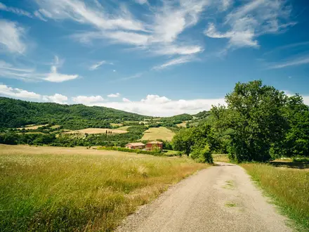
The GR58, or Tour du Queyras, is a hard ~130 km loop through the Parc Naturel Régional du Queyras in the Hautes-Alpes of France. Usually walked in 8-10 days, it suits fit hikers comfortable with repeated long climbs, rocky high passes and refuge-to-refuge logistics. The route is non-technical — no ice axe or crampons are normally needed in season — but the cumulative ascent of about 8,000 m makes it a serious Alpine trek near the Italian border.
Route Overview
The GR58 is a circular Grande Randonnée route, most often started and finished at Ceillac or Château-Ville-Vieille, with Mont-Dauphin-Guillestre as the main rail and road gateway. It is usually walked anti-clockwise, linking Queyras villages and refuges including Saint-Véran, Refuge Agnel, Abriès, Ristolas/L'Échalp, Aiguilles and Arvieux. Major cols include Col Fromage, Col des Estronques, Col de Chamoussière, Col Vieux, Col du Malrif, Col de Péas and Col de Furfande. For comparison with other French mountain walks, see the Chartreuse Trail GR9 segment or the Cirque de Gavarnie trails.
Queyras history and the Escartons
The Queyras formed part of the Briançonnais Escartons, a federation of high Alpine communities granted self-government and fixed taxation rights by the Dauphin in 1343. Those privileges lasted until the French Revolution. The region's isolation helped preserve its stone-and-larch villages, sundials and farming traditions. In 1977 it became the Parc Naturel Régional du Queyras, and the GR58 now follows the FFRandonnée long-distance network around this protected Alpine massif.
Notable highlights
- Saint-Véran (2,042 m): The highest commune in Europe and one of Les Plus Beaux Villages de France. Look for larch-shingle chalets, fuste log lofts, wooden fountains and painted sundials.
- Col de Chamoussière (2,884 m): The highest point on the standard GR58. It also gives access to the optional non-technical detour to Pic de Caramantran and views towards Monte Viso.
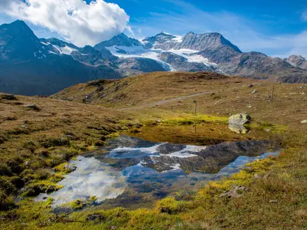
- Lac Foréant and Lac Égorgéou: Glacial lakes below the jagged Crête de la Taillante ridge. They are among the most recognisable scenic stops on the circuit.
- Monte Viso views: The pyramidal Monte Viso, across the Italian frontier, dominates the eastern skyline from several high passes and is the source of the River Po.
- Republic of Escartons heritage: Queyras villages preserve the legacy of a medieval Alpine federation, visible in their stone-and-larch architecture, sundials and mountain farming patterns.
Challenges to expect
Expect sustained ascent and descent on most days, with about 8,000 m of total climbing over the full loop. The walking is non-technical but includes rocky cols, mountain footpaths, pasture tracks and exposed high terrain. Snow can linger on the higher passes into early July, so early-season conditions may slow progress. Book gîtes and refuges well ahead in July-August; bivouac rules are more flexible than in French National Parks, but still regulated.
HikeList Score
GR58 (Queyras Regional Park Trail) scored 86/100 on HikeList's trail-quality metrics.
See score breakdownHide breakdown
- Ideal length 96
- Balanced challenge 80
- Scenery & wildness 85
- Varied terrain 83
- Accommodation 75
- Food & support 88
- Path quality 98
- Season flexibility 76
Computed from length, challenge, scenery & wildness, terrain variety, accommodation, food & support, path quality and season flexibility.
Show more data Show less
- Mountainous
- Forest
- Alpine Meadows
- Rocky
- Dirt
- Pasture Tracks
- Huts
- Guesthouses
- Wild Camping Spots
- Pet Friendly
- Restrooms
- Water Sources
- Campsites
- Shelters
Download Our Full Guide to GR58 (Queyras Regional Park Trail) FREE!
Get our comprehensive guide to this hike for free. Save it for later reading or print out at home.
In these collections
Photos from hikers
Taken on the trail by people who've reviewed GR58 (Queyras Regional Park Trail).
GR58 (Queyras Regional Park Trail): The Complete Guide

The GR58 is a hard, high-Alpine circuit of the Parc naturel régional du Queyras, tucked into the Hautes-Alpes beside the Italian frontier. Most walkers start and finish in Ceillac, linking stone villages, larch forests, high pastures and a succession of serious mountain cols.
This is one of the most rewarding non-technical Alpine tours in France: remote enough to feel wild, yet supported by gîtes d’étape, staffed refuges and well-waymarked GR red-and-white balisage. Saint-Véran, Refuge Agnel, Lac Foréant, Fort Queyras and the Furfande pastures give the route real variety from day to day.
The walking is consistently big. Expect roughly 130 km with around 7,900 m of ascent, with many days crossing passes above 2,300 m and the high point at Col de Chamoussière, 2,884 m.
It suits fit, experienced hillwalkers who are comfortable with long climbs, rocky paths, exposed traverses and rapid changes in mountain weather. In a normal summer it does not require technical equipment, but snow can linger on the highest cols into early July and July-August accommodation should be booked well ahead.
This guide covers stages, daily planning, accommodation, food, transport, terrain and the common mistakes to avoid.
Stage-by-Stage Guide
This stage guide follows the common 10-day Ceillac-based circuit. Distances are approximate, and daily difficulty is driven as much by altitude, ascent and descent as by kilometres: most days involve a significant col (mountain pass), with rocky ground, exposed high sections and possible lingering snow on the highest crossings into early July.
Stage 1: Ceillac to Saint-Véran
Approx. 15 km — via Col des Estronques (2,651 m)
The opening day is a proper Queyras mountain stage rather than a gentle warm-up. From Ceillac, the route climbs towards Col des Estronques, then descends to Saint-Véran, one of the highest permanently inhabited villages in Europe and among the most distinctive overnight stops on the circuit.
Expect a sustained climb on mountain paths, with the character shifting between pasture, stony upper slopes and more sheltered terrain lower down. The pass is high enough for early-season snow patches, and the descent can be hard on tired legs, especially if the weather has turned the path slippery.
The main landmark is the approach to Saint-Véran, known for its larch-shingle chalets, wooden hay lofts, fountains and painted sundials. This is a good stage for settling into the rhythm of the GR58: long climbs, high open ground, then a village finish.
Food and water should be organised in Ceillac before setting out. Saint-Véran has gîte-style accommodation and is a logical place for half-board; any specific shop, café or water-stop availability between the two villages should be checked before travelling.
Ceillac and Saint-Véran are both among the villages served by seasonal ZOU! buses from the Mont-Dauphin–Guillestre gateway, but timetables and reservation requirements change by season. This should be checked before travelling.
Navigation is generally straightforward on the GR red-and-white waymarking, but this is still high-Alpine walking. In poor visibility, pay close attention around Col des Estronques and do not rely on waymarks alone; carry the relevant IGN mapping or the FFRandonnée TopoGuide.
Stage 2: Saint-Véran to Refuge Agnel
Approx. 13 km — via Col de Chamoussière (2,884 m), the high point of the GR58
This is one of the defining stages of the Tour du Queyras. The route leaves Saint-Véran for the high frontier country around Col de Chamoussière, the highest col on the standard GR58, before finishing at Refuge Agnel near the Col Agnel area.
The walking is high, open and rocky, with sustained exposure to weather. There is no technical climbing in normal summer conditions, but this is serious mountain terrain: snow can linger here into early July, and the stage should not be treated casually in bad visibility, strong wind or storms.
Col de Chamoussière gives wide views towards the Italian border and Monte Viso. In settled conditions, fit walkers sometimes add the non-technical detour to Pic de Caramantran, but that option adds effort and should only be considered with adequate time, stable weather and clear navigation.
Food and water planning is simple but important: start supplied from Saint-Véran and do not assume reliable services before Refuge Agnel. Refuge Agnel is a staffed mountain refuge, normally used on half-board by GR58 walkers; booking ahead is important in July and August and opening dates should be checked before travelling.
The Col Agnel area is associated with a high paved pass and road access, but no railway enters the park and public transport arrangements are seasonal. Any use of road access here, including drop-off or pick-up plans, should be checked before travelling.
Navigation needs particular care around the high col and any optional detour. In early season, snow can obscure the path and waymarks; in cloud, the broad high ground can become confusing quickly.
Stage 3: Refuge Agnel to La Monta / L’Échalp
Approx. 14 km — via Col Vieux (2,806 m), Lac Foréant and Lac Égorgéou
This stage links the high refuge country with the upper Guil valley and includes some of the most photographed scenery on the circuit. From Refuge Agnel, the route crosses Col Vieux, then passes the glacial lakes of Lac Foréant and Lac Égorgéou beneath the jagged Crête de la Taillante before descending towards La Monta or L’Échalp.
Terrain is typically high-Alpine: rocky paths near the col, stony traverses and more forgiving ground around the lakes and lower slopes. The descent is long enough to require care, particularly after rain or storms when rock and earth can be slick.
The highlights are concentrated early and mid-stage: Col Vieux, the lakes, the Crête de la Taillante and views towards Monte Viso. This is a stage where leaving early is sensible, both for calmer morning conditions and to allow time around the lakes without rushing the descent.
Carry food from Refuge Agnel unless onward arrangements are already clear. La Monta and L’Échalp are smaller overnight locations than the main Queyras villages, so accommodation and meal availability should be booked and checked before travelling.
Road access in this upper Guil area may make logistics possible, but dependable public transport should not be assumed without checking current ZOU! timetables or local arrangements. This should be checked before travelling.
Navigation is usually helped by the GR waymarking, but the high section around Col Vieux deserves full attention in poor visibility or old snow. Around the lake basins, keep to the marked route to protect fragile alpine ground and avoid losing time on informal tracks.
Stage 4: La Monta / L’Échalp to Abriès
Approx. 15 km — via Colette de Gilly (2,367 m) and the Guil valley
This stage moves through the eastern side of the Queyras and is less extreme in altitude than the preceding high-col days, but it is still a proper walking day. The route uses Colette de Gilly and the Guil valley, with Ristolas and Abriès forming the main settlement sequence on or near this part of the circuit.
Underfoot, expect a mix of valley paths, woodland or pasture sections and rougher mountain tracks around the pass. Although Colette de Gilly is lower than Col de Chamoussière or Col Vieux, the route still involves meaningful ascent and descent and should not be dismissed as an easy valley transfer.
The Guil valley gives a different feel from the open frontier cols, with more settlement contact and opportunities to break up the day. The arrival in Abriès is useful logistically because it is one of the principal Queyras villages on the route.
Food and water are more manageable than on the highest stages, but services in small mountain villages can be seasonal. Plan to leave with what is needed for the day, and check current facilities in La Monta, L’Échalp, Ristolas and Abriès before travelling.
Abriès has gîte-style accommodation and is served by seasonal ZOU! buses in summer. Timetables, operating dates and any booking requirements should be checked before relying on the bus.
Navigation is generally less committing than the previous two stages, but the GR can still be missed where paths, tracks and village approaches intersect. Take care not to drift onto local paths unless deliberately using a signed variant.
Stage 5: Abriès to Les Fonts de Cervières
Approx. 15 km — via Col du Malrif (2,866 m)
This is one of the harder days on the circuit, crossing the high Col du Malrif between Abriès and Les Fonts de Cervières. The altitude, distance and remoteness make it a stage to take seriously, particularly in early summer or unsettled weather.
The route climbs from the valley to a high rocky pass, with exposed upper ground and potentially stony or loose sections near the col. Snow can linger on high north-facing or shaded ground into early July, and visibility can deteriorate quickly if cloud builds over the pass.
The reward is a strong sense of crossing between valleys on a genuine high-Alpine line. Views from around Col du Malrif can be extensive in clear weather, but the main practical concern is safe, steady progress rather than speed.
Leave Abriès with enough food and water for a full mountain day. Les Fonts de Cervières is a smaller end point, and accommodation, meals and water access should be arranged in advance; this should be checked before travelling.
Public transport should not be assumed at Les Fonts de Cervières. If this stage is being used as part of a shorter itinerary or bail-out plan, road access and onward transport must be checked before travelling.
Navigation matters on this stage because the consequences of losing the GR are greater in high, open terrain. Use the red-and-white balisage, but back it up with map, compass and offline GPS mapping, especially if there is snow, mist or storm risk.
Stage 6: Les Fonts de Cervières to Souliers
Approx. 13 km — via Col de Péas (2,629 m)
This stage crosses Col de Péas and continues the pattern of high passes linking small Queyras settlements. It is shorter than some stages on paper, but the col is still above 2,600 m and the day involves serious mountain walking.
The terrain is a mix of mountain footpath, open pasture and stonier upper slopes around the pass. In stable summer weather it is a rewarding crossing; after storms, steeper earth and rock can be slippery, and exposed ground should be cleared before afternoon weather develops.
The stage is quieter and more pastoral in character than the most dramatic frontier sections, but it remains remote enough to require self-sufficiency. Souliers is the key end point and should be treated as a pre-booked overnight rather than a place to arrive speculatively in peak season.
Carry supplies from Les Fonts de Cervières and check what will be available at Souliers before travelling. Small-village food options, evening meals and water access can depend on the accommodation being open and on seasonal service patterns.
There is no rail access anywhere in the park, and public transport for this stage should not be assumed. Any taxi, bus or road-based alternative from Souliers should be checked before travelling.
Navigation is normally helped by the GR marking, but the approach to and descent from Col de Péas require care in cloud or snow patches. Keep to the waymarked line and avoid cutting corners across fragile alpine pasture.
Stage 7: Souliers to Brunissard / Arvieux
Approx. 12 km — via Col du Tronchet (2,347 m), Château-Ville-Vieille and Fort Queyras
This is a more varied stage, combining a pass crossing with a major cultural landmark of the circuit. From Souliers the route uses Col du Tronchet, then passes Château-Ville-Vieille and Fort Queyras before continuing towards Brunissard or Arvieux.
The terrain is less continuously high than the previous big-col stages, but there is still ascent, descent and mixed mountain footing. Expect a combination of paths, valley approaches and settlement-edge walking, with the need to pay attention where the GR threads between villages and local tracks.
Fort Queyras, also known as Château-Queyras, is the obvious highlight: a 13th-century clifftop fortress on a glacial rock lock, later remodelled by Vauban, guarding the Guil valley. This stage also gives useful access to Château-Ville-Vieille and the Arvieux valley side of the loop.
Food and water opportunities are more plausible around the villages than on the remote high stages, but exact opening times and services should be checked before travelling. Brunissard and Arvieux are practical overnight areas, with gîte-style accommodation in Arvieux and nearby settlements; book ahead in July and August.
Château-Ville-Vieille and Arvieux are among the Queyras villages served by seasonal ZOU! buses from the Mont-Dauphin–Guillestre gateway. This makes Stage 7 one of the more useful sections for joining, leaving or rescheduling the circuit, but current timetables must be checked before relying on them.
Navigation can be fiddlier around settlements than on an obvious ridge or col. Watch for GR red-and-white waymarks at junctions, especially where local paths, roads and village lanes meet.
Stage 8: Brunissard / Arvieux to Refuge de Furfande
Approx. 13 km — via Col de Furfande (2,500 m)
This stage climbs out of the Arvieux / Brunissard area towards Col de Furfande and the high pastures around Refuge de Furfande. It is a classic western-side Queyras day: a valley departure, a substantial ascent, then a remote refuge finish in open alpage country.
The route uses mountain paths through lower larch country before reaching more open and stonier ground near the col. Although Col de Furfande is lower than the highest passes earlier in the route, the ascent is sustained and the refuge setting is remote enough to make weather and timing important.
The Furfande area is one of the strongest landscape highlights of the western circuit, with high pastures and a remote refuge-and-hamlet atmosphere. It is a good place to slow down if time allows, but only after reaching the booked overnight safely.
Carry enough food and water from Brunissard or Arvieux for the climb. Refuge de Furfande is a staffed mountain refuge in season, and half-board should be booked ahead; opening dates and current arrangements should be checked before travelling.
Arvieux has seasonal ZOU! bus access, making the start of the stage logistically useful. Do not plan on public transport at Refuge de Furfande itself unless a specific road arrangement has been made and checked before travelling.
Navigation is important on the climb and around the open pastures, where multiple tracks or animal paths can be misleading. In poor visibility, stay disciplined with map and waymark checks rather than following the most trodden line.
Stage 9: Refuge de Furfande to Bramousse
Approx. 12 km — via Col de la Lauze (~2,000 m) and Escoyères
This stage leaves the Furfande high pastures and works back towards inhabited lower ground via Col de la Lauze and Escoyères, ending at Bramousse. It is shorter and lower than the biggest GR58 mountain days, but it still includes meaningful descent and careful navigation through changing terrain.
Expect a transition from open alpage to more sheltered paths and village approaches. Descents can be tiring after several days on the circuit, and loose or wet ground may make the stage slower than the distance suggests.
Escoyères is the main place passed before Bramousse and provides a useful landmark on the western side of the loop. The day is less about dramatic high cols and more about linking the remote Furfande sector back towards the final Ceillac crossing.
Start from Refuge de Furfande with the day’s food and water sorted. Accommodation and meal options in Bramousse are likely to be more limited than in the larger Queyras villages, so the overnight should be arranged in advance; this should be checked before travelling.
Public transport should not be assumed at Bramousse or Escoyères without checking current local arrangements. If using this stage as an exit or contingency point, confirm road access and onward transport before committing to the plan.
Navigation requires attention after leaving the refuge area and again around Escoyères and Bramousse, where local routes may intersect the GR. Keep checking the red-and-white balisage and avoid complacency simply because the altitude is lower.
Stage 10: Bramousse to Ceillac
Approx. 12 km — via Col de Bramousse (2,251 m)
The final stage closes the circuit by crossing Col de Bramousse back to Ceillac. It is not the highest day on the GR58, but it still asks for a proper climb and descent before the loop is complete.
The terrain returns to the familiar Queyras mix of mountain footpaths, larch woodland, pasture and stonier ground around the pass. After nine days of accumulated fatigue, the climb to Col de Bramousse can feel harder than its height suggests, so it is worth starting with the same discipline as on earlier stages.
The main highlight is the satisfaction of the final col and the descent back into Ceillac, the most common start and finish point for the circuit. In clear weather, the last crossing gives a useful final overview of the terrain that makes the GR58 such a demanding route: steep valleys, high passes and compact mountain villages.
Carry enough food and water from Bramousse, especially if leaving early before local services are open. Ceillac has gîte-style accommodation and is the practical place to spend a final night if onward transport does not line up with the walking day.
Ceillac is served by seasonal ZOU! buses connecting with the Mont-Dauphin–Guillestre rail gateway. Timetables, operating days and any reservation requirements should be checked before travelling, particularly outside the busiest summer period.
Navigation is usually straightforward if visibility is good, but the final day still crosses a real pass. Do not relax route-finding standards until Ceillac is reached, and be cautious on wet descents or any early-season snow remaining near the col.
Recommended Itinerary
Standard itinerary: 10 days from Ceillac
The most balanced plan is the classic 10-stage anti-clockwise circuit from Ceillac. It keeps the high passes manageable, uses the main village and refuge stops, and avoids turning the final western section into very long days.
Book accommodation before committing to dates, especially in July and August. Several stages depend on staffed refuges or small village gîtes, and opening dates can vary across the mid-June to late-September walking season.
| Day | From | To | Approx. distance | Why this stage makes sense | Services/accommodation notes |
|---|---|---|---|---|---|
| 1 | Ceillac | Saint-Véran | 15 km | A strong opening stage over Col des Estronques (2,651 m), giving an immediate feel for the repeated high-col pattern of the GR58. | Ceillac and Saint-Véran have established walker accommodation. Saint-Véran is a key overnight stop, but beds should still be booked ahead in peak season. |
| 2 | Saint-Véran | Refuge Agnel | 13 km | Shorter in distance but high and committing, crossing Col de Chamoussière (2,884 m), the high point of the route. The shorter mileage is useful because altitude, weather and lingering snow can slow progress. | Refuge Agnel is the logical staffed mountain-refuge stop near the Col Agnel area. Book ahead and check opening dates before travelling. |
| 3 | Refuge Agnel | La Monta / L'Échalp | 14 km | A scenic high-mountain stage over Col Vieux (2,806 m), passing Lac Foréant and Lac Égorgéou before descending towards the upper Guil valley. | La Monta and L'Échalp are small stage-end settlements. Accommodation and meal availability should be checked before fixing this night. |
| 4 | La Monta / L'Échalp | Abriès | 15 km | A useful transition stage through the Guil valley area, with the Colette de Gilly (2,367 m) rather than one of the highest cols. It provides a less severe day after the Refuge Agnel–Col Vieux section. | Abriès is one of the main Queyras villages with gîte-style accommodation. It is a good place to reset before the harder Col du Malrif day. |
| 5 | Abriès | Les Fonts de Cervières | 15 km | One of the more serious stages, crossing Col du Malrif (2,866 m). The standard itinerary sensibly gives it a full day rather than pairing it with another major pass. | Les Fonts de Cervières is a small high-stage stop. Check current accommodation, meals and opening dates before booking the surrounding nights. |
| 6 | Les Fonts de Cervières | Souliers | 13 km | Crosses Col de Péas (2,629 m) and keeps the daily distance moderate after Col du Malrif. This is a practical split before dropping towards Château-Ville-Vieille and the Arvieux side. | Souliers is a small village stop. Accommodation should be arranged in advance, with a fallback plan checked before travelling. |
| 7 | Souliers | Brunissard / Arvieux | 12 km | A shorter stage over Col du Tronchet (2,347 m), with the route passing Château-Ville-Vieille and Fort Queyras before reaching the Arvieux/Brunissard area. | Arvieux is one of the better-established accommodation villages on the circuit; Brunissard is also used as a stage point. Reserve ahead in summer. |
| 8 | Brunissard / Arvieux | Refuge de Furfande | 13 km | Climbs back into high pasture country over Col de Furfande (2,500 m). Ending at Refuge de Furfande keeps the western side of the loop from becoming an overlong crossing. | Refuge de Furfande is a staffed mountain refuge and should be booked in advance. Check opening dates carefully outside the main summer season. |
| 9 | Refuge de Furfande | Bramousse | 12 km | A shorter but still mountainous day via Col de la Lauze and Escoyères. It positions the walk well for the final crossing back to Ceillac. | Bramousse is a small stage-end stop. Confirm accommodation and meals before booking the final night. |
| 10 | Bramousse | Ceillac | 12 km | A fitting final stage over Col de Bramousse (2,251 m), closing the loop back to Ceillac without needing onward trail transport. | Ceillac has walker accommodation and is the usual start/finish. ZOU! bus connections back towards Mont-Dauphin–Guillestre should be checked before travelling. |
Slower variant: 11–12 days
A slower schedule suits walkers who want more margin for weather, lingering snow on the highest cols, or simply shorter recovery days between major passes. Rather than changing the whole route, add one or two extra nights at larger service villages such as Saint-Véran, Abriès or Arvieux, or use an extra night to avoid rushing onward after a refuge stage.
This approach is especially sensible early in the season, when Col de Chamoussière, Col Vieux and Col du Malrif may still be affected by snow. Exact split points depend on accommodation availability, so check official mapping and current gîte/refuge openings before booking.
Faster variant: 7–8 days
A faster schedule is only for very fit, efficient hillwalkers comfortable with repeated long Alpine days and sustained descent on stony paths. The usual way to shorten the circuit is to combine some of the shorter standard stages, but this removes recovery time and can make bad weather much harder to manage.
Possible combinations include Refuge Agnel to Abriès via La Monta / L'Échalp, or Refuge de Furfande to Ceillac via Bramousse. These are long mountain days created by combining standard stages, so distances and timings should be checked on official mapping before booking accommodation.
A 5-day version is sometimes quoted, but it is a fast, compressed itinerary rather than the recommended plan for most independent walkers. For a first GR58, the 10-day schedule gives a much better balance of altitude, weather flexibility and accommodation logistics.
Planning the Route
How many days to allow
Most walkers should plan the GR58 as an 8–10 day circuit. The 10-stage version is the most straightforward to book because it lines up naturally with established villages and staffed refuges, including Saint-Véran, Refuge Agnel, Abriès, Les Fonts de Cervières, Souliers, Arvieux/Brunissard, Refuge de Furfande and Bramousse.
A fit party with light packs can compress the route into 7–8 days, but that usually means longer days, fewer recovery margins and less flexibility if weather blocks a high col. A very fast crossing is possible for strong mountain walkers, but it is not the best way to plan a first Tour du Queyras: the route gains and loses height almost every day, and several stages cross cols above 2,600 m.
For most independent hikers, the safest planning assumption is: book the 10-day structure unless there is a clear reason to go faster. It gives better spacing between overnight stops, makes the high sections less rushed, and leaves more margin for snow, storms or a slow descent on loose ground.
Stage planning is shaped by accommodation
The GR58 is not a route where daily distances can be adjusted anywhere at will. Overnight options are concentrated in villages, gîtes d'étape and a few key staffed refuges, so the practical stage ends matter as much as the map distance.
Refuge Agnel and Refuge de Furfande are particularly important because they sit on the higher, wilder parts of the circuit. If either refuge is full or closed, the surrounding stage plan may need to change substantially rather than simply shifting the night by a kilometre or two.
July and August accommodation should be booked well ahead. Gîtes and refuges are seasonal, with the main walking window roughly mid-June to late September, but exact opening dates should be checked before travelling.
Choosing a start point
Ceillac is the most common start and finish, and it works well because the circuit closes cleanly there. The loop can also be joined at Château-Ville-Vieille, Saint-Véran, Abriès or Arvieux, which can be useful if transport, accommodation or an existing itinerary makes another village easier.
Because this is a closed circuit, there is no separate finish transfer to arrange if the route is completed in full. The main transport planning is getting into the Queyras at the start, usually via Mont-Dauphin–Guillestre railway station and onward ZOU! buses into the park villages.
ZOU! services are seasonal and may require advance reservation for some journeys. Timetables should be checked before travelling, especially outside the peak summer period.
Shortening, extending and variants
The full waymarked circuit is often planned at about 130 km when the usual high variants are included, while shorter measurements are used for the core loop. In practice, the exact distance depends on the variant choices and where the circuit is joined.
Shortening the walk is easiest by starting in, finishing in or leaving from one of the bus-served Queyras villages rather than trying to cut across the mountains ad hoc. Château-Ville-Vieille, Saint-Véran, Abriès and Arvieux are the most useful planning points for this because they are recognised access villages on the circuit.
Extensions and high-level options should be planned from proper mapping and current local conditions. The optional non-technical detour to Pic de Caramantran from the Col de Chamoussière area is the best-known summit addition, but it should only be added in stable weather with enough time and energy after the main col crossing.
Section hiking
Section hiking is practical, but it is more constrained than on a lowland trail with frequent public transport. No railway enters the Queyras itself, so access depends on buses from Mont-Dauphin–Guillestre and the seasonal services between the valley villages.
The most realistic section breaks are the villages already on or close to the route: Ceillac, Saint-Véran, Abriès, Château-Ville-Vieille and Arvieux. A section plan should be built around current ZOU! timetables first, then accommodation availability second, rather than assuming a bus will be available at the end of any walking day.
Key planning priorities
| Priority | What matters on the GR58 |
|---|---|
| Accommodation | Book gîtes and refuges in advance, especially in July-August. Check seasonal opening dates before committing to travel. |
| Food | Half-board accommodation is common, but do not assume every hamlet has a shop. Plan food around the main villages and overnight stops. |
| Water | Carry enough between valleys, refuges and villages. Availability can vary with season and location, so ask locally before each high stage. |
| Navigation | The route uses GR red-and-white waymarking, but map and compass or a reliable offline GPX are still important on high cols, in poor visibility or where snow obscures the path. |
| Mapping | Use IGN TOP 25 3637OT for most of the circuit and 3537ET for the Furfande/western side. The FFRandonnée TopoGuide for the GR58 is the definitive walkers’ guide. |
| Weather | Plan early starts for the bigger col days. Storms, snow patches and wet rock can make non-technical ground much slower and more serious. |
| Transport | Check trains to Mont-Dauphin–Guillestre and seasonal ZOU! buses into the Queyras before booking the first and last nights. |
| Bivouac | Bivouac is more flexible than in French National Parks but still regulated, generally between dusk and dawn and away from villages. This should be checked before travelling. |
Weather and snow margins
The main season is summer into early autumn, but the highest cols can hold snow into early July. This matters most around the bigger passes such as Col de Chamoussière, Col Vieux and Col du Malrif, where lingering snow can slow progress or make route-finding less obvious.
September often gives cooler, quieter walking, but the days are shorter and accommodation may start to reduce operations later in the month. A late-season itinerary should avoid overlong stages that depend on finishing in daylight after a high col.
A sensible planning approach
For a first GR58, build the itinerary around the established 10-stage pattern, book every night, then adjust only if fitness, transport and accommodation clearly support a faster schedule. Keep at least one practical buffer in the wider travel plan rather than booking a tight onward connection immediately after the final stage.
The route is non-technical, but the planning should be treated as high-Alpine planning: secure beds, carry proper mapping, check bus times, ask about snow and weather locally, and do not rely on being able to improvise accommodation in the busiest weeks.
Towns, Villages and Overnight Stops
Accommodation on the GR58 is a mix of village gîtes d'étape and staffed high refuges. In July and August, beds and half-board meals should be booked well ahead; outside peak summer, opening dates are seasonal and should be checked before travelling.
Do not plan this route as a casual resupply walk with shops every day. The main villages are the sensible places to top up food, while the smaller hamlets and high refuges are primarily overnight and meal stops. Carry enough lunch food and snacks to cover the next stage whenever leaving a village.
Ceillac
Ceillac is the most common start and finish for the circuit, and a practical place to spend the night before the first stage over Col des Estronques to Saint-Véran. It is also where the loop closes after the final crossing of Col de Bramousse from Bramousse.
The village has gîte-style accommodation suitable for GR walkers, with the usual Queyras pattern of half-board, showers and dorm or private-room options. If arriving late by bus, arrange accommodation in advance rather than assuming a walk-in bed.
Ceillac is one of the key access villages served by summer ZOU! buses from Mont-Dauphin–Guillestre railway station. Timetables and any reservation requirements should be checked before travelling, especially at the beginning and end of the walking season.
Use Ceillac to sort final food, gas or packed-lunch arrangements before starting. Specific shop and café opening times vary seasonally, so this should be checked before travelling.
Saint-Véran
Saint-Véran is the first major overnight stop on the classic Ceillac-based itinerary, reached after crossing Col des Estronques. At roughly 2,042 m, it is a high village, so it also gives a useful early sense of how the route handles altitude, weather and cool evenings.
It is one of the best village stops on the eastern side of the loop, with gîtes d'étape and walker-focused accommodation. Half-board is the simplest option, as the next stage heads into higher, wilder terrain towards Col de Chamoussière and Refuge Agnel.
Saint-Véran is served by summer ZOU! buses into the Queyras, making it a viable alternative start or finish point for section hikers. Services are seasonal and should be checked before travelling.
The village is worth an overnight rather than a rushed pass-through: it has historic larch-shingle chalets, wooden hay lofts, fountains and sundials, but the main practical reason to stop is to reset before the highest col of the tour.
Col Agnel Area / Refuge Agnel
Refuge Agnel is the key high-mountain overnight stop between Saint-Véran and the upper Guil valley. It sits below the Col Agnel area after the crossing of Col de Chamoussière, the high point of the GR58.
This is a staffed refuge rather than a village stop. Expect the usual refuge pattern: booked beds, evening meal, breakfast, limited personal space and a stronger need to carry any extra snacks or lunch food required for the following day.
There are no village services here. Do not rely on shops, cafés or transport from the refuge area unless specifically arranged; walkers should treat it as a remote mountain halt.
This stop makes logistical sense because it breaks up one of the highest parts of the circuit. It also positions walkers well for the next stage over Col Vieux, past Lac Foréant and Lac Égorgéou, before descending towards La Monta or L'Échalp.
La Monta, L'Échalp and Ristolas
La Monta and L'Échalp are used as overnight or stage-end options after the descent from Refuge Agnel via Col Vieux and the lakes. Ristolas lies in the same upper Guil valley corridor and is relevant for walkers adjusting the stage before continuing towards Abriès.
These are valley stops rather than large service centres. Accommodation and meal arrangements should be made in advance, especially if choosing one hamlet over another at the end of the stage.
Food options should not be assumed late in the day. Carry lunch from Refuge Agnel or arrange packed food when booking, then use the valley stop to recover before the next section over Colette de Gilly and down the Guil valley.
Transport details for these smaller places are not specified here. This should be checked before travelling.
Abriès
Abriès is one of the main practical stops on the eastern half of the GR58 and a natural overnight after the La Monta / L'Échalp stage. It is also one of the recognised places where the circuit can be joined.
The village has gîte d'étape accommodation suited to long-distance walkers, with half-board commonly the most efficient arrangement. It is a sensible place to wash kit, reorganise food and prepare for the more demanding crossing of Col du Malrif towards Les Fonts de Cervières.
Abriès is served by summer ZOU! buses, so it works well for section-hiking, late starts, bail-out plans or joining the loop without beginning in Ceillac. Bus timetables are seasonal and should be checked before travelling.
For food, treat Abriès as one of the better opportunities on the route to resupply or arrange supplies, but do not leave this to chance. Current shop, café and opening details should be checked before travelling.
Aiguilles
Aiguilles sits in the Guil valley area near the eastern side of the circuit and is relevant for walkers using valley services or adjusting stages around Abriès. It is not one of the fixed overnight stops in the classic 10-stage Ceillac itinerary, but it can matter for alternative planning.
Accommodation and services may be useful if the itinerary is being shortened, lengthened or adapted around weather and transport. Exact options should be checked before travelling.
Do not rely on Aiguilles as a guaranteed same-day solution without checking where the GR58 line, accommodation and onward transport fit your chosen stage plan. It is best treated as a nearby valley service point rather than an automatic GR58 night halt.
Les Fonts de Cervières
Les Fonts de Cervières is the overnight target after the high crossing of Col du Malrif from Abriès. This is one of the more remote-feeling stage ends on the northern part of the circuit.
Accommodation should be booked before committing to the stage, as alternatives are not as straightforward as in the larger Queyras villages. Meal arrangements are particularly important here because the next day crosses Col de Péas towards Souliers.
Expect limited services compared with Abriès, Saint-Véran or Ceillac. Carry essential snacks and do not assume a full resupply point.
Souliers
Souliers is the stage-end after crossing Col de Péas from Les Fonts de Cervières. It is a small mountain village stop before the route continues over Col du Tronchet and towards Château-Ville-Vieille, Arvieux or Brunissard.
It is a useful overnight because it breaks the northern and western sections into manageable days. Book accommodation and meals ahead, and check whether packed-lunch options are available when reserving.
Village services should be treated as limited unless current opening information says otherwise. This should be checked before travelling.
Château-Ville-Vieille and Fort Queyras
Château-Ville-Vieille lies in the Guil valley and is one of the recognised places where the GR58 can be joined. The route passes the Château-Queyras / Fort Queyras area, a major landmark above the valley.
For hikers, its main value is logistical: it is a valley access point, a possible overnight or itinerary-adjustment stop, and a place to connect with transport if not completing the full loop from Ceillac. Summer ZOU! buses serve Château-Ville-Vieille, but timetables should be checked before travelling.
Accommodation and food options should be arranged in advance if planning to stop here rather than continuing towards Arvieux or Brunissard. It can be a useful place to reset after the Souliers stage before the route turns back into higher ground.
Arvieux
Arvieux is one of the main accommodation villages on the western side of the circuit and a recognised access point for joining the GR58. It is commonly paired with Brunissard as the overnight area before the climb towards Col de Furfande and Refuge de Furfande.
The village has walker-friendly gîte accommodation, and half-board is the simplest arrangement before the next high stage. It is also a sensible place to organise food before heading into the more remote Furfande sector.
Arvieux is served by summer ZOU! buses into the Queyras. Check current timetables before travelling, especially if using it for a shortened itinerary or as an exit point.
Brunissard
Brunissard is the practical alternative to Arvieux for the overnight before the Furfande stage. It lies on the route corridor after the Souliers to Château-Ville-Vieille / Arvieux section and before the climb to Col de Furfande.
It is a useful staging point if accommodation in Arvieux is full or if the chosen itinerary naturally finishes the day higher up the valley. Book ahead and confirm evening meal and breakfast arrangements.
Do not assume extensive shops or café options. If the following day goes to Refuge de Furfande, leave with enough food for the day and any items not provided by the refuge.
Refuge de Furfande
Refuge de Furfande is the key high refuge on the western side of the GR58, reached after crossing Col de Furfande from the Arvieux / Brunissard area. It sits in the Furfande high pastures and gives the route one of its more remote overnight experiences.
This is a staffed mountain refuge, so book a bed and meals in advance. Space, facilities and food choice will be more limited than in a village gîte, and walkers should carry any specialist dietary items, extra snacks or lunch food needed for the following stage.
There are no normal village services here. Treat it as a self-contained mountain stop between Arvieux / Brunissard and the descent towards Escoyères and Bramousse.
Escoyères
Escoyères comes on the descent from Refuge de Furfande towards Bramousse. On the classic 10-stage split it is more of a pass-through or intermediate place than the main overnight target.
It can still matter for pacing, weather decisions or itinerary adjustments on the western side of the loop. Accommodation, food and any onward options should be checked before travelling if planning to stop here.
Do not count on Escoyères for a guaranteed resupply. Carry enough food from Refuge de Furfande or the previous village to reach the intended night stop.
Bramousse
Bramousse is the final overnight stop on the classic Ceillac itinerary, reached after the Furfande stage via Escoyères and before the last crossing of Col de Bramousse back to Ceillac. It is a strategically important stop because it prevents the final two western stages being forced into one long day.
Accommodation and evening meals should be booked ahead. The next day is not especially long by GR58 standards, but it still involves a proper mountain pass before the loop closes.
Services should be treated as limited. Arrange breakfast and packed food when booking, and check current local options before travelling.
Getting to the Start
Ceillac is the most common start and finish for the GR58, but the circuit can also be joined at Château-Ville-Vieille, Saint-Véran, Abriès or Arvieux. The key access point for public transport is Mont-Dauphin–Guillestre railway station, followed by a ZOU! regional bus into the Queyras villages.
Because the GR58 is a loop, there is no separate finish transfer to arrange: whichever village you start from is where you return on foot.
By train
The nearest railway station is Mont-Dauphin–Guillestre. It is the rail-and-road gateway for the Queyras; no railway runs into the park itself.
Mont-Dauphin–Guillestre is served by the overnight Paris–Briançon Intercités de nuit and by regional TER trains via Marseille, Valence or Gap. For most walkers arriving from outside the region, the practical plan is to reach one of these rail corridors, travel to Mont-Dauphin–Guillestre, then continue by bus into the Queyras.
Allow generous connection time at Mont-Dauphin–Guillestre. Mountain bus services are seasonal and may not run late enough to meet every train. This should be checked before travelling.
By bus
From Mont-Dauphin–Guillestre station, ZOU! buses run up the Guil valley towards the Queyras villages, including access for Ceillac, Château-Ville-Vieille, Saint-Véran, Abriès and Arvieux in summer.
Frequencies are seasonal, and some services may need advance reservation. Check the current ZOU! timetable before booking trains, especially if arriving early or late in the day, outside July-August, or on a weekend. This should be checked before travelling.
If the bus connection does not work, a pre-booked local taxi is the usual fallback from the railhead to the start village. Do not rely on finding one at short notice after an evening train; arrange it in advance.
By car
Driving gives the most flexibility if starting somewhere other than Ceillac, or if travelling outside the main summer bus season. The common start villages on the loop include Ceillac, Château-Ville-Vieille, Saint-Véran, Abriès and Arvieux.
Long-stay parking arrangements vary by village and season. Before leaving a vehicle for 8-10 days, ask your accommodation or the local tourist office where walkers are expected to park and whether any time limits or restrictions apply. This should be checked before travelling.
The main advantage of driving is independence from the ZOU! timetable. The disadvantage is that the car must be left for the whole circuit, so the safest plan is to start and finish in the same village and book accommodation there for the first and final nights.
From the nearest airport
There is no airport access directly into the Queyras. The practical airport strategy is to fly into a city with onward rail connections to the Marseille, Valence, Gap or Paris–Briançon rail routes, then continue by train to Mont-Dauphin–Guillestre and bus into the park.
Do not plan a same-day international flight, train, bus and first hiking stage unless the timings are very clear. A missed ZOU! connection can leave you short of options, particularly outside the busiest summer period. This should be checked before travelling.
Where to stay before starting
The cleanest logistics are to sleep in the start village the night before walking. Ceillac is the most common choice, with gîtes d'étape and village accommodation suited to walkers starting the circuit.
If joining the loop elsewhere, Saint-Véran, Abriès, Aiguilles, Arvieux and other Queyras villages have gîte-style accommodation used by GR58 walkers. July and August should be booked well ahead, and opening dates outside the main summer season should be checked before travelling.
If arriving late by train, consider whether it is more practical to overnight near the rail-and-road gateway and take the bus into the Queyras the next morning. This depends on current train and ZOU! timings, so it should be checked before travelling.
Getting Home from the Finish
The GR58 is a closed circuit, so there is normally no separate end-to-end transfer to organise: you finish back in the village where you began. For most walkers this is Ceillac, but the same principle applies if the loop was joined at Château-Ville-Vieille, Saint-Véran, Abriès or Arvieux.
The key onward gateway is Mont-Dauphin–Guillestre railway station. No railway enters the Queyras itself, so leaving the finish usually means taking a ZOU! regional bus, taxi or private transfer from your finish village down to the station, then continuing by train.
By train
The nearest practical railway station is Mont-Dauphin–Guillestre. From there, onward rail options include the overnight Paris–Briançon Intercités de nuit and regional TER services via Marseille, Valence or Gap.
Build in margin between the mountain bus and the train, especially if travelling at the end of the day. Queyras bus services are seasonal and can be limited, and missed connections may mean an unplanned night near the station or back in the valley.
Current train times and reservations should be checked before travelling, particularly for the night train and any onward long-distance connection.
By bus
ZOU!, the Provence-Alpes-Côte d’Azur regional network, runs buses between Mont-Dauphin–Guillestre station and the Queyras villages in summer. Relevant GR58 access points include Ceillac, Château-Ville-Vieille, Saint-Véran, Abriès and Arvieux.
Frequencies are seasonal rather than turn-up-and-go. Some services may need advance reservation, especially on-demand sections, so check the ZOU! timetable and booking requirements before committing to a same-day train.
If finishing in Ceillac, plan the final walking day with the bus timetable in mind. The last stage still crosses Col de Bramousse, so a late finish can make it more sensible to stay in Ceillac and travel out the following morning.
By car/taxi
Because the GR58 returns to its start point, walkers arriving by car can normally leave from the same village where they parked before the hike. Parking arrangements are local and should be checked before leaving a vehicle for several days.
Taxis or private transfers can be useful if the ZOU! timetable does not line up with your finish, if you are leaving outside the main summer bus period, or if you need an early train from Mont-Dauphin–Guillestre. Availability in the Queyras is limited compared with larger Alpine resorts, so book ahead and confirm the fare before relying on a taxi.
From the nearest airport
Air travel is not the main access method for the GR58. The practical route out is still to reach Mont-Dauphin–Guillestre first, then continue by rail via Marseille, Valence or Gap according to your onward airport or city connection.
The best airport will depend on current rail schedules and flight plans rather than the trail itself. This should be checked before travelling.
Where to stay at the finish
Staying overnight at the finish is often the safest plan if the final stage ends late, if weather has slowed progress over the last col, or if onward buses are sparse. Ceillac has gîte-style accommodation used by GR58 walkers, and the other access villages on the circuit also have hiker accommodation.
Expect the usual Queyras mix of gîtes d’étape with half-board, hot meals, showers and dorm or private-room options. July and August should be booked well ahead, and opening dates outside the main summer season should be checked before travelling.
Which Direction Should You Walk?
The GR58 is most commonly walked anti-clockwise from Ceillac. This is the standard pattern used by many 8–10 day itineraries: Ceillac to Saint-Véran, Refuge Agnel, La Monta / L’Échalp, Abriès, Les Fonts de Cervières, Souliers, Arvieux / Brunissard, Refuge de Furfande, Bramousse and back to Ceillac.
Because the GR58 is a closed circuit, direction makes little difference to the basic transport plan. You return on foot to whichever village you started from, so there is no separate finish transfer to organise. Ceillac is the usual start, but Château-Ville-Vieille, Saint-Véran, Abriès and Arvieux can also work if bus times and accommodation fit; ZOU! bus timetables from Mont-Dauphin–Guillestre should be checked before travelling.
Anti-clockwise: the standard choice
Walking anti-clockwise gives a strong mountain start. The first stage from Ceillac to Saint-Véran crosses Col des Estronques, then the route reaches the high point at Col de Chamoussière on the way towards Refuge Agnel. Col Vieux, Lac Foréant and Lac Égorgéou follow soon after, so several of the biggest eastern Queyras highlights come early.
The trade-off is that there is not much gentle build-up. Within the first two days, you are already crossing cols above 2,600 m and 2,800 m, so this direction suits walkers who arrive fit, acclimatised enough for high Alpine walking, and ready for long climbs and descents from the start.
Accommodation flow is one of the main reasons to follow the standard direction. The 10-stage structure links villages and staffed refuges at sensible intervals, including Refuge Agnel and Refuge de Furfande on the more remote sections. In July and August, the limiting factor is often bed availability rather than direction, so book the whole chain before fixing travel.
Clockwise: perfectly possible, but less conventional
Walking clockwise reverses the same logistics rather than creating new ones. From Ceillac, you would first head towards Bramousse and the western side of the loop before reaching Refuge de Furfande, Arvieux / Brunissard, Souliers, Les Fonts de Cervières, Abriès and then the eastern high cols later in the trek.
This can feel more progressive because the very highest point, Col de Chamoussière, comes near the end rather than on day two of the classic anti-clockwise schedule. It also saves Saint-Véran, Refuge Agnel, Col Vieux and the frontier views towards Monte Viso for the final part of the circuit.
The reverse direction may be useful if accommodation availability forces the itinerary, especially at the staffed refuges or in the smaller villages. It is also a valid choice for walkers who prefer the psychological lift of finishing with the eastern high mountains rather than reaching them early.
Climbs, weather and underfoot conditions
There is no major overall difficulty advantage either way: the total ascent and descent are the same, and almost every day involves a significant col. What changes is the order in which the bigger passes arrive. Anti-clockwise puts Col des Estronques, Col de Chamoussière and Col Vieux early; clockwise delays those higher crossings until later.
There is no practical prevailing-wind advantage on this circuit. The more important planning point is daily timing on exposed high ground: start early enough to cross cols in stable conditions, and treat lingering snow into early July or slippery ground after storms as a reason to slow down or alter plans.
Recommendation
For most walkers, especially on a first Tour du Queyras, the best choice is anti-clockwise from Ceillac. It follows the most common accommodation rhythm, reaches the classic eastern Queyras scenery quickly, and matches the standard village-to-village planning structure.
Choose the reverse direction only if it solves accommodation availability, suits a preferred start village, or you deliberately want to save the highest and most dramatic cols for the final days.
Accommodation Along the Route
The GR58 is well suited to village-to-village and refuge-to-refuge walking, but it is not a route where accommodation can be left to chance in high season. The standard circuit uses a mix of Queyras village gîtes d'étape and staffed mountain refuges, with half-board commonly used so hikers do not need to carry several days of evening meals.
Ceillac, Saint-Véran, Abriès and Arvieux are the strongest bases for choice and flexibility. The more remote overnight points — especially Refuge Agnel, Les Fonts de Cervières, Souliers, Refuge de Furfande and Bramousse — need more careful booking because options are limited and alternatives may involve a significant change to the stage plan.
Booking strategy
Book all overnights in advance for July and August, and do not rely on turning up at staffed refuges. The walking season is roughly mid-June to late September, but gîte and refuge opening dates are seasonal and should be checked before travelling.
September is generally quieter than July-August, but days are shorter and some services may begin to wind down. Early-season hikers should also check snow conditions on the higher cols, as lingering snow can affect whether a booked stage is sensible.
Half-board is the simplest arrangement for most walkers. It reduces food weight and removes the uncertainty of finding dinner in small villages or remote hamlets after a long col crossing.
Accommodation by place
| Place | Accommodation level | Best for | Notes |
|---|---|---|---|
| Ceillac | Good | Start/finish night, buffer day, first/last resupply planning | The most common start and finish for the loop, with village gîte-style accommodation. Useful for arriving the day before the hike rather than starting straight after transport. |
| Saint-Véran | Good | Classic first overnight from Ceillac | A major GR58 stop with strong walker infrastructure. Book early in high season, as it is also a destination village in its own right. |
| Refuge Agnel / Col Agnel area | Limited | High-refuge night between Saint-Véran and the upper Guil valley | A key staffed refuge on the wilder eastern section. Capacity is finite and there is no like-for-like village alternative at the pass, so booking is important. |
| La Monta / L'Échalp | Limited | Overnight after Col Vieux, Lac Foréant and Lac Égorgéou | Small valley settlements rather than large service centres. Accommodation should be arranged before setting out from Refuge Agnel. |
| Ristolas | Limited | Possible valley stop or adjustment point | On the Guil valley section near the standard route corridor. Useful if adjusting stages, but do not assume broad choice without checking. |
| Abriès | Good | Comfortable village stop, regrouping point | One of the stronger accommodation villages on the circuit, with gîte-style options suited to GR walkers. A practical place after the La Monta / L'Échalp stage. |
| Aiguilles / nearby valley | Good to limited | Alternative valley logistics or stage adjustment | The route passes near the Aiguilles valley area. It can help with flexible planning, but exact accommodation location relative to the GR58 should be checked before booking. |
| Les Fonts de Cervières | Limited | Remote overnight after Col du Malrif | A small high-valley stop, not a place to improvise late in the day. Reserve ahead and confirm opening dates. |
| Souliers | Limited | Overnight between Col de Péas and the Château-Ville-Vieille / Arvieux side | A small settlement where accommodation choice is likely to be narrow. Plan this night before committing to the surrounding stages. |
| Château-Ville-Vieille | Limited to good | Stage adjustment, valley access, Fort Queyras area | A useful valley point on or near many GR58 itineraries. It can help break or modify stages, but availability should be checked before relying on it. |
| Arvieux | Good | Village-based overnight before the Furfande section | One of the stronger accommodation areas on the western side of the loop. Useful for walkers wanting a more serviced stop before heading to Refuge de Furfande. |
| Brunissard | Good to limited | Alternative to Arvieux depending on stage split | Often paired with Arvieux in itineraries. Check the exact location of the booked lodging against the following day’s route to Col de Furfande. |
| Refuge de Furfande | Limited | Remote high-pasture refuge night | A key staffed refuge on the western side of the circuit. Book ahead, especially in July-August, as the next practical alternative may require changing the stage. |
| Escoyères | Limited | Descent-stage waypoint | The route passes via Escoyères after Refuge de Furfande. It is better treated as a route point unless accommodation has been specifically arranged. |
| Bramousse | Limited | Final overnight before returning to Ceillac | A small stop before Col de Bramousse and the closing stage to Ceillac. Reserve ahead rather than assuming space. |
Inn-to-inn practicality
The GR58 works well for independent inn-to-inn walkers who are comfortable with gîtes d'étape and mountain refuges rather than hotels every night. Expect dormitory accommodation to be common, although some gîtes in the larger villages may offer private rooms.
A hotel-only version is harder to plan because the standard itinerary includes remote overnights such as Refuge Agnel and Refuge de Furfande. Avoid designing a comfort-only itinerary unless the longer stage distances, transfers or alternative stops have been checked carefully before booking.
Luggage, transfers and awkward gaps
Do not assume routine luggage transfer across the full GR58. The circuit crosses high cols and uses remote refuges, so baggage logistics are less straightforward than on lower-level inn-to-inn routes.
Where a stage feels too long or a stop is full, the usual solution is to adjust the itinerary around the larger villages such as Ceillac, Saint-Véran, Abriès and Arvieux, rather than relying on last-minute transport. ZOU! buses serve Queyras villages seasonally from the Mont-Dauphin–Guillestre gateway, but local timetables and any on-demand arrangements should be checked before travelling.
Taxi transfers or private shuttles may help with some valley adjustments, but they should be arranged directly and in advance. This should be checked before travelling.
Bivouac and camping
Bivouac is more freely permitted in the Queyras than in France’s National Parks, but it is still regulated. As a general rule, plan for dusk-to-dawn bivouacking away from villages, and check current local rules before relying on it.
A bivouac plan does not remove the need for proper mountain logistics. Weather can change quickly on the high cols, water and food planning become more important, and refuges or gîtes may still be needed if storms or snow affect the route.
Camping and Wild Camping
Camping the GR58 is possible, but it needs more planning than a hut-to-hut or gîte-to-gîte itinerary. The route is a high-Alpine circuit with repeated cols above 2,300 m, long exposed sections and seasonal refuges/gîtes, so most tent users will still rely on villages and staffed refuges for meals, showers, resupply and bad-weather backup.
Formal campsites
Specific campsite availability is not fixed enough to assume stage by stage. Do not plan the GR58 on the basis that every village stop has a campsite; this should be checked before travelling.
Where formal camping is available, it is most likely to be in or near valley settlements rather than on the high cols. Useful places to check when building a camping itinerary include the main route villages and valley stops: Ceillac, Saint-Véran, La Monta, L'Échalp, Ristolas, Abriès, Aiguilles, Château-Ville-Vieille, Arvieux, Brunissard and Bramousse.
For July and August, book or enquire ahead wherever possible. The Queyras is busy in peak summer, and a small campsite or camping area can fill just as easily as a gîte dormitory.
Wild camping and bivouac rules
The GR58 is inside the Parc naturel régional du Queyras, not a French National Park, so bivouac is generally treated more flexibly than in many stricter protected areas. It is still regulated: the practical rule is to bivouac discreetly between dusk and dawn, away from villages, roads, buildings, cultivated land and obvious livestock areas.
Do not pitch a tent early in the afternoon and leave it standing as a base camp. Keep the shelter small, arrive late, leave early and move on each morning.
Local rules can change, and restrictions may apply around particular hamlets, refuges, lakes, grazing areas or sensitive habitats. This should be checked locally before camping, especially in the Col Agnel area, around Refuge de Furfande and near popular lake locations such as Lac Foréant and Lac Égorgéou.
Does the GR58 suit a camping itinerary?
The GR58 suits experienced backpackers who are comfortable carrying a tent over repeated big-ascent days. It is less suited to walkers hoping for easy low-level camping every night, because many stages cross high, rocky cols before dropping into settlements or refuges.
A mixed approach is often the most practical: camp on suitable valley nights, use gîtes or refuges during poor weather, and consider half-board stops where food carry would otherwise become heavy. Refuge Agnel and Refuge de Furfande are particularly useful logistical anchors on the wilder parts of the loop.
The extra weight matters on this route. Nearly every day involves sustained ascent and descent, and a heavy camping pack will be felt on cols such as Col des Estronques, Col de Chamoussière, Col Vieux, Col du Malrif, Col de Péas, Col de Furfande and Col de Bramousse.
Where camping is most practical
Camping is most manageable around lower valley settlements and near established overnight stops, provided local rules allow it. The least practical places are exposed high cols, steep traverses, scree zones and open ridges where there is little shelter from wind or storms.
Good planning principles for this route:
- Use villages such as Ceillac, Saint-Véran, Abriès, Arvieux/Brunissard and Bramousse for services and recovery nights.
- Treat high sections such as the Col de Chamoussière–Col Agnel area and the Furfande side of the circuit as weather-dependent.
- Avoid camping close to lakes, watercourses, huts, farm buildings, roads and grazing animals unless a designated area or local permission is clear.
- Do not rely on finding a perfect pitch late in the day after a high col; identify realistic lower alternatives before setting out.
Water and food planning
Water is available in villages and at staffed accommodation when open, but high sections can be exposed and committing. Carry enough water before leaving settlements, especially on hot days and before long climbs to the cols.
Natural water should be treated or filtered. Do not assume that streams, lakes or troughs are safe to drink from, particularly in grazing areas.
Food planning is easier if the camping itinerary is linked to village stops and refuges. A fully self-sufficient camping traverse is possible only with careful resupply planning and a realistic pack weight; most walkers will find it more efficient to buy meals or provisions in the route villages where available.
Fires, waste and Leave No Trace
Open fires should be avoided. The Queyras has extensive larch forest, dry summer conditions can occur, and fire restrictions may be in force; this should be checked locally. Use a stove only where it is safe and permitted, and never cook on dry grass, forest litter or inside a tent porch without proper ventilation.
Leave No Trace standards are essential:
- Pack out all rubbish, including food scraps and toilet paper.
- Camp on durable ground and avoid fragile alpine vegetation.
- Keep well away from water when washing, toileting or cooking.
- Do not disturb livestock, shepherding areas or refuge operations.
- Leave no visible trace of the pitch when packing up.
Seasonal considerations
The realistic camping season broadly follows the walking season: mid-June to late September, with the same caveats as the main route. Snow can linger on the highest cols into early July, and early-season nights at altitude can be cold.
July and August bring the warmest conditions but also the busiest accommodation and camping pressure. September is quieter and often clearer, but days are shorter and nights are colder, so late starts and long evening searches for a pitch are a poor strategy.
Storms are a serious consideration on a camping itinerary. If thunder is forecast, avoid committing to exposed cols late in the day and be ready to use a village gîte or staffed refuge rather than camping high.
Food, Water and Resupply
Food strategy on the GR58
The simplest and most reliable food plan is to book half-board in gîtes d'étape and staffed refuges, with breakfast and an evening meal included. Many walkers also order a packed lunch from the accommodation for the next day, which is especially useful before the higher, more remote stages.
Food is easiest in the established Queyras villages such as Ceillac, Saint-Véran, Abriès, Aiguilles, Château-Ville-Vieille, Arvieux and Brunissard. Even so, this is a high mountain circuit, not a town-to-town lowland trail: village shops, cafés and restaurants can have seasonal hours, lunch closures and weekly closing days. This should be checked before travelling, especially outside July and August.
Do not assume that every overnight stop has a shop. Refuge Agnel, Les Fonts de Cervières, Souliers, Refuge de Furfande and Bramousse should be treated as limited-resupply stops unless a meal, picnic or other food has been arranged in advance. Carry enough spare food to cover at least the current stage and the next morning if a booking or shop plan fails.
There is no need to carry food for the whole circuit if using gîtes and refuges, but it is sensible to carry a reserve of high-energy snacks. On the wilder stages, particularly around Col de Chamoussière, Col Vieux, Col du Malrif, Col de Péas and Col de Furfande, there may be no practical food option between breakfast and the evening stop.
Water on the trail
Refill treated water at accommodation whenever possible, and start each day with enough for the main climb and col crossing. Most stages climb above 2,300 m, and several cross cols around or above 2,800 m, where exposed ground, wind and sun can make water needs higher than the map distance suggests.
Natural water is likely in valleys, pastures and near lakes, but it should not be treated as automatically safe. The route crosses grazing country and high-alpine terrain, so stream, lake and spring water should be filtered, boiled or chemically treated unless it is clearly signed as potable. Village fountains should also not be assumed drinkable unless marked as drinking water.
As a practical baseline, most walkers should leave each overnight stop with around 1.5–2 litres, carrying more in hot weather or before long high traverses. Early-season snowmelt and late-season dry spells can both affect where water is available; local advice from the previous night’s gîte or refuge is valuable.
Food and water by section
| Section | Food availability | Water availability | Notes |
|---|---|---|---|
| Ceillac to Saint-Véran | Food available at the start and evening stop if using village accommodation; arrange lunch before leaving Ceillac. | Refill in Ceillac and Saint-Véran. Natural water en route should be treated. | Crosses Col des Estronques at 2,651 m; carry lunch and enough water for the climb and descent. |
| Saint-Véran to Refuge Agnel | Saint-Véran is the key food point; Refuge Agnel can provide meals if booked. | Refill before leaving Saint-Véran and at Refuge Agnel. Do not rely on untreated high-level sources. | This is one of the highest days, crossing Col de Chamoussière at 2,884 m. Carry a full day’s food unless a refuge picnic has been arranged. |
| Refuge Agnel to La Monta / L'Échalp | Meals at Refuge Agnel if booked; onward food at La Monta / L'Échalp should be arranged with accommodation. | Refill at the refuge before leaving. Lakes and streams near Col Vieux and the descent should be filtered or treated. | Passes Lac Foréant and Lac Égorgéou after Col Vieux. These are not guaranteed potable water sources. |
| La Monta / L'Échalp to Abriès | Limited food before Abriès; rely on booked accommodation or carry supplies. | Refill before setting off and again in Abriès. Treat natural water in the Guil valley and on the climb. | A shorter-feeling valley-linked day than the highest stages, but still carry lunch rather than relying on cafés. |
| Abriès to Les Fonts de Cervières | Abriès is an important resupply point; Les Fonts de Cervières should be treated as limited unless meals are booked. | Refill in Abriès. Treat any streams or springs before drinking. | Crosses Col du Malrif at 2,866 m, another long high section with no dependable food between ends. |
| Les Fonts de Cervières to Souliers | Food should be arranged at Les Fonts de Cervières and Souliers; do not assume shop resupply. | Refill before leaving. Natural water on the way to Col de Péas should be treated. | Carry a full day’s lunch and snacks for the crossing of Col de Péas. |
| Souliers to Brunissard / Arvieux | Possible village food opportunities around Château-Ville-Vieille and Arvieux, but opening times are not guaranteed. | Refill at Souliers and at the evening stop. Treat natural water. | This is one of the better stages for passing through settlements, but rural closures can still disrupt plans. |
| Brunissard / Arvieux to Refuge de Furfande | Brunissard / Arvieux are the main food points; Refuge de Furfande provides meals if booked. | Refill before leaving and at Refuge de Furfande. Treat any water in the Furfande pastures. | Crosses Col de Furfande at 2,500 m; carry lunch from the valley unless the refuge or gîte has supplied one. |
| Refuge de Furfande to Bramousse | Meals at Refuge de Furfande if booked; Bramousse should be treated as limited for resupply. | Refill at the refuge before descending. Treat water near Escoyères or on the route. | Carry food for the day rather than relying on intermediate services. |
| Bramousse to Ceillac | Arrange breakfast/lunch at Bramousse; Ceillac has the best end-of-loop food options. | Refill before leaving Bramousse and again in Ceillac. Treat natural water on the climb to Col de Bramousse. | Final climb over Col de Bramousse still needs proper food and water, despite being the last stage. |
Practical resupply tips
Book evening meals and packed lunches at the same time as beds, particularly for Refuge Agnel, Refuge de Furfande and small village stops. In July and August, accommodation and meal capacity can fill well ahead.
Carry a compact reserve such as nuts, bars, cheese, dry sausage, bread or other durable food that survives a warm pack. This is more useful than trying to plan precise lunchtime purchases in small villages.
Sunday and off-season opening hours can affect cafés, small shops and village services. If starting from Ceillac or joining the loop at Château-Ville-Vieille, Saint-Véran, Abriès or Arvieux, buy or collect enough food for the first full stage before leaving the valley. Current shop hours, refuge opening dates and meal availability should be checked before travelling.
Terrain, Conditions and Difficulty in Practice
The GR58 is hard because it is repeatedly high, steep and remote rather than technically difficult. In normal summer conditions it is a walking route, not a mountaineering route: no ice axe or crampons are required, and the way is marked with the red-and-white GR balisage. The practical challenge is sustaining big ascent and descent over many consecutive days, often with a high col above 2,300 m between one night’s stop and the next.
Daily distances can look moderate on paper, but the profile is alpine. The full circuit gains roughly 7,900 m, and several stages cross passes near or above 2,800 m, including Col de Chamoussière at 2,884 m, Col Vieux at 2,806 m and Col du Malrif at 2,866 m. A fit hillwalker may find the individual stages manageable; the cumulative effect of ten days of climbing, descending, altitude and weather exposure is what makes the route serious.
Underfoot: rock, scree, pasture and larch forest
Expect a mix of rocky mountain footpaths, stony col approaches, scree near the higher passes, alpine-meadow tracks and shaded larch-forest paths on the descents. The trail is generally on proper mountain paths rather than faint wilderness lines, but “good path” in the Queyras still means loose stone, eroded zigzags, uneven rock steps and sections where poles are useful.
The high cols are the roughest parts of the route. Col des Estronques, Col de Chamoussière, Col Vieux, Col du Malrif, Col de Péas and Col de Furfande all involve sustained climbing and descent on high mountain terrain. These sections are non-technical in settled summer weather, but they demand sure-footedness and steady pacing, particularly when tired or carrying a full pack.
Lower down, the descents into villages such as Saint-Véran, Abriès, Arvieux, Bramousse and Ceillac often pass through pasture, meadow and larch woodland. These sections can feel easier underfoot, but long downhill days are still hard on knees and feet. After rain or storms, shaded forest paths and grassy slopes can become slippery even when the rock higher up has dried.
Exposure and technical difficulty
The GR58 is not a scrambling route and does not normally involve technical climbing. The seriousness comes from exposed high ground, long traverses, loose surfaces and the lack of quick escape once committed to a pass crossing. Several stages spend long periods above the valley floor, where wind, lightning risk, poor visibility or lingering snow can turn a straightforward walking day into a much more demanding one.
Exposure should be understood in the mountain-walking sense: open slopes, high traverses, rocky col approaches and steep drops nearby, rather than via ferrata-style terrain. Walkers comfortable on Lake District, Scottish or Alpine mountain paths should find the movement familiar, but anyone uneasy on loose rock or steep descents should allow extra time and avoid compressing the itinerary too aggressively.
Snow, storms and seasonal conditions
The normal walking season is roughly mid-June to late September, but the highest passes can hold snow into early July. This matters most on the high cols: old snow on steep approaches can obscure the path, make footing insecure and increase the consequence of a slip. Col de Chamoussière, Col Vieux and Col du Malrif are the key places where early-season conditions should be checked before travelling.
July and August usually offer the warmest conditions and the greatest availability of seasonal refuges and gîtes, but they are also the busiest months. Afternoon storms are a real planning issue on high Alpine routes: start early on long col days, aim to be over the highest ground before deteriorating weather, and do not rely on mobile reception as the only safety tool.
September is often cooler, clearer and quieter, but days are shorter and nights at altitude can be cold. A slower morning start or a navigational delay has more consequence late in the season, especially on stages linking Refuge Agnel, Les Fonts de Cervières or Refuge de Furfande with the next valley accommodation.
Mud, bog and waterlogged ground
Mud and bog are not the main difficulty on the GR58. This is not a wet lowland or peatland trail; the tougher surfaces are usually rock, scree and steep mountain path. After storms, however, grassy alpage tracks, forest descents and shaded paths can become greasy, and loose stones can shift underfoot on the way down from the cols.
Water management is still important because long exposed climbs can be hot and dry in summer. Do not assume that every high section has reliable water on demand. Refill in villages, gîtes and refuges, and check each day’s options locally before leaving.
Road walking, villages and pasture sections
The GR58 is primarily a mountain-path circuit rather than a road-walking route. Road and village sections are incidental parts of linking accommodation, services and valley crossings, especially around settlements such as Ceillac, Saint-Véran, Abriès, Château-Ville-Vieille, Arvieux and Brunissard. The high-road environment around the Col Agnel area is part of the landscape, but the difficulty of the route comes from the mountain crossings, not tarmac mileage.
Pasture and alpage sections are common, especially around the higher grazing areas and the Furfande side of the loop. Stiles, gates and fenced-field navigation are not a defining planning issue in the way they are on some British trails; the priority is staying on the marked GR line, respecting working mountain pasture and avoiding shortcuts across fragile slopes.
What makes it harder in practice
The hardest version of the GR58 is an early-season or fast itinerary with several high cols still holding snow, a heavy pack and little recovery time between stages. A 7–8 day schedule is realistic only for strong walkers who are already comfortable with repeated 1,000 m-style mountain days. The 10-stage version gives more time to absorb the climbs, manage weather and descend carefully.
The route also becomes harder when accommodation choices force a long day over a high pass. Refuge-to-refuge and village-to-village logistics can limit flexibility, so booking should be matched to walking ability rather than simply to availability. In July and August, book well ahead; outside peak season, opening dates should be checked before travelling.
What makes it easier
The waymarking, village infrastructure and staffed refuges make the GR58 more manageable than a remote off-trail Alpine traverse. Overnight stops in places such as Ceillac, Saint-Véran, Abriès, Arvieux and the staffed refuges reduce the need to carry camping equipment and multiple days of food. This lowers pack weight, which makes a major difference on the long descents.
Good weather, a sensible pace and an itinerary that respects the height gain are the biggest advantages. Start early, keep high-col days flexible where possible, use poles if they help on loose descents, and carry proper mountain layers even in warm weather. The GR58 rewards efficient, experienced hillwalking habits far more than speed.
Weather and Best Time to Walk
The GR58 is a summer and early-autumn trek. In normal hiking terms, the realistic walking season is roughly mid-June to late September, with conditions depending heavily on snow remaining on the high cols and on the opening dates of gîtes and refuges.
This is a high-Alpine circuit, not a low-level valley walk. Almost every stage crosses a col above 2,300 m, with the highest point at Col de Chamoussière (2,884 m), so weather should be planned for as mountain weather even when the Queyras villages are warm and settled.
Best months
| Period | What to expect | Planning advice |
|---|---|---|
| Mid-June to early July | Early-season conditions. Snow can remain on the highest passes, especially around Col de Chamoussière, Col Vieux and Col du Malrif. | Check current snow conditions before travelling. Some accommodation may still be on seasonal opening dates, so confirm refuge and gîte availability before booking transport. |
| July | Main summer season. Warmer conditions, longer daylight and generally the most straightforward time for a full circuit. | Book accommodation well ahead, especially in villages and staffed refuges. Start early on high-col days to reduce exposure to afternoon storms. |
| August | Warm, busy and fully in season. The trail, gîtes and refuges are likely to be at their busiest. | Advance booking is strongly advised. Carry enough water between villages/refuges, and treat exposed climbs and descents seriously in heat or thunderstorms. |
| September | Often the best balance for experienced walkers: cooler, clearer and quieter, with larch forests beginning to turn towards autumn colour later in the month. | Days are shorter and nights colder. Check accommodation closing dates carefully, especially for staffed refuges such as Refuge Agnel and Refuge de Furfande. |
| October to early June | Outside the normal trekking season. Snow, cold, closed accommodation and winter mountain conditions become the main issue. | Not a realistic standard GR58 season for independent hikers following the summer route. Winter travel would require different skills, equipment and local condition checks. |
Snow and early-season conditions
Snow can linger on the highest cols into early July. This matters because the GR58’s difficulty comes less from technical climbing and more from repeated high passes, steep climbs, rocky traverses and long descents.
The most important early-season checks are the high crossings: Col de Chamoussière, Col Vieux, Col du Malrif, Col de Péas and Col de Furfande. Even short snow patches can make wayfinding harder, slow the day down and increase the consequence of slips on steep ground.
In normal summer conditions the route does not require ice axe or crampons, but that assumes the cols are clear enough for ordinary mountain walking. If significant snow remains, delay the trip, alter the itinerary or take local advice.
Heat, storms and exposed ground
July and August bring the warmest walking, but the route still climbs repeatedly to cold, windy high ground. A hot climb out of a valley can be followed by a chilly, exposed col crossing within the same stage.
Afternoon storms are a key summer hazard on high Alpine routes. The GR58 has long open sections above the villages, including the approach to Col de Chamoussière, the Col Vieux area near Lac Foréant and Lac Égorgéou, and the higher crossings on the northern and western parts of the loop.
Plan to leave early on big-col days and avoid being on exposed ridges, cols or scree in deteriorating weather. After storms, rocky paths and larch-forest descents can be slippery, and visibility can drop quickly in cloud or fog.
Daylight and pace
July gives the most forgiving daylight window for the full 8–10 day circuit. This is helpful because many days involve both a major ascent and a major descent, rather than a simple point-to-point valley walk.
By September, the route is often quieter and cooler, but shorter days reduce the margin for slow progress, navigation delays or weather interruptions. A headtorch should still be carried, but the better strategy is to keep stage lengths realistic and start early.
Accommodation season and weather planning
Accommodation availability is seasonal. Gîtes d’étape in villages such as Ceillac, Saint-Véran, Abriès, Aiguilles, Arvieux and others, plus staffed refuges including Refuge Agnel and Refuge de Furfande, should be checked before committing to dates.
This is especially important at the edges of the season. A June itinerary can be affected by both snow and unopened accommodation; a late-September itinerary can be affected by shorter days, colder nights and closing dates.
In July and August, the issue is usually capacity rather than closure. Book beds and half-board in advance, particularly if walking the classic 10-stage itinerary or relying on specific refuges between village stops.
Is the GR58 possible in winter?
The GR58 should be treated as a summer/early-autumn hiking route. In winter and spring, the high cols, scree slopes and exposed traverses are likely to be affected by snow, cold and mountain hazards well beyond the normal scope of this non-technical trek.
A winter attempt is not a standard long-distance walking option. Anyone considering the Queyras outside the normal season needs appropriate winter mountain competence, specialist equipment and current local condition information.
Safety Notes
The GR58 is a non-technical walk in normal summer conditions, but it is still a serious high-Alpine route. The main risks are altitude, exposure, fast-changing weather, long descents, lingering snow and the fact that several days commit you to high cols before the next village or refuge.
Emergency number and mobile signal
In France, call 112 for emergency help. Save it before starting, and keep enough phone battery for navigation and calls rather than using it heavily for photos or entertainment.
Do not assume continuous mobile signal. The route crosses remote cols, high pastures and valley sections where reception may be intermittent, especially away from villages such as Ceillac, Saint-Véran, Abriès, Aiguilles, Arvieux and the Guil valley settlements.
Carry offline maps, a paper map or guide, and the details of each night’s accommodation. If walking solo, leave the day’s intended stage and expected arrival point with someone reliable.
Weather and exposure
Most stages cross open ground above 2,300 m, with several high passes near or above 2,800 m, including Col de Chamoussière, Col Vieux and Col du Malrif. These are not places to be caught by poor visibility, thunder, strong wind or a sudden temperature drop.
Start early on high-col days and check the forecast before leaving the village or refuge. If thunderstorms, heavy rain, strong wind or poor visibility are forecast, be ready to delay, shorten the day or use a lower variant where one is available.
Even in summer, carry waterproofs, a warm layer, hat and gloves. September often gives clearer, quieter walking, but the shorter days and cooler mornings make timing more important.
Snow and early-season conditions
Snow can linger on the highest cols into early July. The GR58 normally requires no ice axe or crampons in summer conditions, but a snow-covered col can change the seriousness of the day quickly.
Before crossing the higher passes, check current conditions with your accommodation, the local tourist office or other reliable local advice. If a slope is hard, icy or exposed, do not treat it as a normal summer footpath.
Navigation
The GR58 is waymarked with red-and-white GR balisage, but waymarks are not a substitute for navigation. In mist, after storms, or across stony ground near cols and scree, the line can become harder to follow.
Carry the relevant IGN mapping and/or the FFRandonnée TopoGuide, plus offline GPX mapping if using a phone. Keep the next named col, refuge, village and valley direction clear in mind before setting out each morning.
Terrain, slips and fatigue
The route has sustained ascent and descent almost every day, with rocky paths, scree near cols, pasture tracks, larch-forest descents and steep valley drops. Wet rock, mud and polished stones can be slippery after storms.
Trekking poles are useful for the long descents and for balance on loose ground. Fatigue is a real safety factor on this circuit: the cumulative ascent is close to 8,000 m, so a stage that looks moderate on distance can still be demanding.
Heat, cold and water
The Queyras can be hot in summer valleys and cold on exposed high ground on the same day. Carry enough water for the full stage, especially when leaving villages or refuges for high pastures and cols.
Do not rely on untreated streams or lakes as safe drinking water. If taking natural water, treat or filter it. Avoid risky shortcuts to water on steep, wet or loose banks, and do not underestimate how cold alpine lakes and streams can be.
Livestock and pasture areas
The GR58 crosses alpine pastures and high alpages. Give livestock plenty of space, avoid walking through the middle of a herd, and keep food packed away when stopping.
If animals are on or near the path, slow down and pass calmly. Do not feed or touch livestock, and close any gates or barriers exactly as found.
Roads and village approaches
Road walking is not a major feature of the GR58, but short road sections and village approaches occur, and the route passes the Col Agnel area near a high paved road pass. Stay visible, walk facing traffic where appropriate, and take extra care in poor visibility or at bends.
Solo hiking
Solo walkers should be competent at navigation, weather judgement and making conservative decisions. The route is popular in season, but there are still remote sections where help may not be immediate.
Carry a headtorch, emergency food, spare warm layer and a basic first-aid kit. Do not press on over a high col late in the day simply to keep to an accommodation booking; contact the accommodation if delayed wherever signal allows.
Check before setting off each day
Before leaving each morning, check:
- the mountain weather forecast for wind, thunder, rain and visibility;
- current snow conditions on the day’s col, especially before early July;
- the exact stage objective and any lower or shorter alternatives;
- daylight hours and realistic walking time for the group;
- water and food for the full day;
- that the next gîte or refuge is open and booked;
- phone battery, offline maps and emergency contact details;
- whether seasonal transport or services are needed from a village. This should be checked before travelling.
Gear Recommendations
The GR58 is non-technical in normal summer conditions, but it is still a high-Alpine circuit with repeated cols above 2,300 m, rocky paths, scree, exposed traverses and long climbs. Pack for mountain weather rather than village-to-village rambling: light enough for 7,700–7,900 m of ascent, but robust enough for cold wind, storms and rough ground.
Footwear
Choose footwear with a stiff enough sole for stony cols and long descents. Lightweight mountain boots or robust trail shoes both work for experienced walkers, but soft road-style shoes are poorly suited to the scree and rocky paths around passes such as Col de Chamoussière, Col Vieux, Col du Malrif and Col de Furfande.
Waterproof boots are useful in early season when snow patches may linger high up, and after storms when paths through larch forest and pasture can be wet and slippery. Trail runners can be sensible for fast, sure-footed hikers in settled summer weather, but they need good grip and enough underfoot protection for repeated rocky days.
Waterproofs and warm layers
Carry full waterproofs every day: jacket and overtrousers, not just a windshirt. The route spends many hours above the tree line, and a storm or cold wind on a 2,600–2,800 m col can turn a warm valley day into serious mountain conditions.
A warm layer should be accessible, not buried at the bottom of the pack. A fleece or light insulated jacket, hat and gloves are sensible even in July and August, especially for early starts from high refuges such as Refuge Agnel or Refuge de Furfande. September walkers should expect cooler mornings, shorter days and a greater need for insulation.
Navigation
The GR58 is a waymarked GR route with red-and-white balisage, but do not rely on paint marks alone. Mist, snow patches, storm damage or simple inattention can make high crossings and pasture sections harder to follow.
Carry offline mapping and a back-up. The FFRandonnée TopoGuide for the GR58 is the most route-specific walking guide, and the relevant IGN TOP 25 maps are 3637OT for most of the circuit and 3537ET for the Furfande/western side. A phone with offline maps is useful, but a paper map and basic compass remain sensible on this route.
A power bank is strongly recommended. Long days, navigation apps, photos and cold temperatures can drain a phone quickly, and not every overnight stop should be treated as a guaranteed charging point.
Water and food carry
Do not plan the GR58 as if water and food are available continuously along the path. Villages and staffed refuges break up the circuit, but the high cols often involve long climbs and exposed sections where there may be no reliable supply when it is needed.
Start each stage with enough water for the full climb and high crossing, especially on hot days between Saint-Véran, Refuge Agnel, Col Vieux, Abriès, Les Fonts de Cervières and the Furfande area. A refill plan is useful, but it should not replace carrying enough to be self-sufficient for several hours.
Most inn-to-inn walkers use half-board in gîtes and refuges, but lunch and snacks still need planning. Carry dense food for the day rather than assuming a shop, café or picnic supply will appear at the right time. This is particularly important before the more remote stages and when walking outside the busiest July-August period.
Trekking poles
Trekking poles are strongly recommended. The route has sustained ascent and descent almost every day, with around 8,000 m of total climbing and many long drops into valleys. Poles reduce strain on knees and help with balance on scree, loose stones, wet grass and tired late-day descents.
They are also useful if early-season snow patches remain near the highest cols, though poles are not a substitute for the right skills or equipment on hard snow. If significant snow remains on high passes, conditions should be checked before travelling.
For inn-to-inn hikers
Inn-to-inn walkers can keep packs relatively light because gîtes d'étape and staffed refuges provide the overnight structure. A compact sleeping liner is typically useful for refuge and gîte stays, along with lightweight hut clothing, earplugs and a small towel.
The main mistake is underpacking for the high ground because the nights are indoors. Even with booked accommodation, every day still requires waterproofs, warm layers, navigation, headtorch, first-aid basics, food and water. July-August accommodation should be booked well ahead; outside peak season, opening dates should be checked before travelling.
For campers and bivouac hikers
Camping gear needs to be light but mountain-capable. The Queyras involves steep daily climbing, so excessive tent, stove and sleep-system weight will be felt quickly, but flimsy summer-only gear is a poor choice for high pastures, cold nights and storms.
Bivouac is more freely permitted than in French National Parks, but it is still regulated, generally between dusk and dawn and away from villages. Campers should carry a shelter that can handle wind, a warm enough sleeping bag and mat for Alpine nights, and enough food capacity for less serviced sections.
A camping itinerary also needs more margin. Bad weather on a high col, a closed seasonal facility or a missed resupply opportunity can have a bigger effect when carrying food and shelter. Refuge and gîte opening dates, local bivouac rules and current conditions should be checked before travelling.
For fast or section hikers
Fast walkers and section hikers can strip weight, but the non-negotiables stay the same: waterproof shell, warm layer, navigation, headtorch, food, water and emergency basics. The GR58 is not a low-level trail where a minimalist running vest is automatically enough for a full stage.
For single-day sections from villages such as Ceillac, Saint-Véran, Abriès, Arvieux or Château-Ville-Vieille, plan around the same high-col conditions as the full circuit. Public transport in the Queyras is seasonal and no railway enters the park, so spare clothing and enough food are prudent if a day takes longer than expected. Current ZOU! bus timetables should be checked before travelling.
Seasonal extras
For mid-June to early July, be prepared for lingering snow on the highest cols. In normal summer conditions the GR58 does not require ice axe or crampons, but snow-covered passes are a different proposition; if conditions are still wintry, either carry appropriate equipment and know how to use it, or change plans.
For July and August, sun protection matters: sunglasses, high-factor sunscreen, a cap or brimmed hat and enough water capacity for hot climbs. Much of the route is high and exposed, even though descents pass through larch forest.
For September, prioritise warmth, a reliable headtorch and earlier starts. The walking is often quieter and cooler, but shorter daylight leaves less room for delays on long high stages.
Budget and Costs
Costs on the GR58 vary mainly with accommodation style. A village-and-refuge itinerary using half-board in gîtes d'étape and staffed refuges is the normal planning baseline; bivouac can reduce costs, while private rooms, extra nights and luggage services raise them quickly.
All costs are in euros (€). Exact prices change by season and operator, so current gîte, refuge, transport and package prices should be checked before booking.
Main cost categories
| Cost item | What to budget for on the GR58 |
|---|---|
| Accommodation | Dorm beds or private rooms in gîtes d'étape in Ceillac, Saint-Véran, Abriès, Aiguilles, Arvieux and other villages; staffed refuge nights at places such as Refuge Agnel and Refuge de Furfande. Half-board is common and often the simplest option. |
| Food | Evening meals and breakfasts are often included in half-board. Budget separately for picnic lunches, snacks, drinks and any meals in villages. |
| Transport to the route | Rail to Mont-Dauphin–Guillestre, then ZOU! bus into the Queyras villages. Train fares vary heavily by route and booking time. Bus timetables and any reservation requirements should be checked before travelling. |
| Local transport and taxis | The loop returns to the start, so no end-to-end transfer is needed. A contingency budget is sensible in case weather, injury or fatigue forces an early exit to a village and onward transport. Availability and cost of local taxis should be checked before travelling. |
| Camping / bivouac | Bivouac is more freely permitted than in France’s National Parks, but is still regulated and generally limited to dusk-to-dawn use away from villages. Do not assume formal campsite availability without checking current local options. |
| Luggage transfer | Not essential, but may be available through accommodation providers or walking-holiday operators. This should be checked before travelling, especially for the higher refuge sections. |
| Guided or self-guided packages | Package trips may bundle accommodation, meals, route notes and sometimes baggage logistics. They cost more than arranging the walk independently but reduce booking admin. Current inclusions and prices should be checked carefully. |
Budget approach
The lowest-cost approach is a lightweight itinerary mixing bivouac with occasional gîte or refuge nights. This keeps accommodation spending down, but increases pack weight and requires more self-sufficiency with food, weather protection and stove/cooking arrangements where appropriate.
This approach still needs paid nights on some stages unless the itinerary is planned very carefully around legal bivouac spots. It is also less forgiving in poor weather, when a gîte or refuge bed may be the safer and more comfortable choice.
Standard independent budget
Most walkers should budget around a half-board gîte/refuge itinerary. This is the most practical GR58 style: walk village to village or refuge to refuge, eat a hot evening meal, carry only lunches and snacks, and avoid the weight of full camping kit.
For an 8–10 day circuit, the biggest cost will be nightly half-board. Add train travel to Mont-Dauphin–Guillestre, ZOU! bus fares into and out of the Queyras, lunches, snacks, drinks, maps or guidebook, and a small contingency for transport or an unplanned extra night.
Comfortable budget
A more comfortable itinerary uses private rooms where available, extra nights in villages such as Ceillac, Saint-Véran, Abriès or Arvieux, and possibly luggage support on sections where it can be arranged. This is the easiest way to reduce daily strain, but availability is limited in the smaller villages and refuges.
Private rooms should be booked well ahead for July and August. Refuge nights on the wilder sections, including Refuge Agnel and Refuge de Furfande, may still involve shared facilities even on a higher-budget trip.
Cost-saving tips
- Start and finish in the same village to avoid paying for a separate finish transfer; the GR58 is a closed circuit.
- Book gîtes and refuges early for July and August, when last-minute availability can be poor.
- Use half-board where it avoids buying or carrying full evening meals.
- Carry supermarket or bakery food from villages when possible, but do not rely on every stop having full resupply.
- Keep a contingency fund for weather delays, missed buses, injury or an unplanned taxi.
- Check ZOU! bus timetables before fixing train tickets, as services into the Queyras are seasonal.
Luggage Transfer, Guided Tours and Support Services
The GR58 can be walked fully independently, but support services are useful if you want to reduce pack weight, have accommodation booked in advance, or build in road transfers around the Queyras villages. Because this is a high-Alpine circuit with staffed refuges as well as village gîtes, do not assume that every overnight stop can take delivered luggage.
Luggage transfer
Luggage transfer is most useful on the village-to-village parts of the route, where overnight stops include places such as Ceillac, Saint-Véran, Abriès, Aiguilles, Arvieux, Brunissard, Château-Ville-Vieille and Bramousse. It is less straightforward on the higher refuge stages, particularly where the itinerary uses Refuge Agnel and Refuge de Furfande.
If using luggage transfer, check before booking that bags can be delivered to every planned overnight stop, not just to the main road villages. Some hikers may need to carry an overnight kit for refuge stages while sending a larger bag ahead to the next accessible village.
Key points to arrange in advance:
| Service point | What to check |
|---|---|
| Bag delivery coverage | Whether the provider serves every gîte/refuge on your exact itinerary |
| Refuge stages | Whether luggage can reach Refuge Agnel and Refuge de Furfande, or whether you must carry essentials |
| Bag limits | Maximum weight, labelling rules and drop-off times |
| Season | Services may follow the main walking season, roughly mid-June to late September |
| July-August | Book well ahead, as accommodation and transfers are busiest |
Prices vary by provider, itinerary, number of bags and whether the transfer is part of a walking-holiday package. Confirm current prices and delivery conditions before booking.
Self-guided packages
Self-guided walking-holiday packages suit hikers who are comfortable walking independently but want the logistics arranged. A typical package may include pre-booked accommodation, half-board in gîtes or refuges, route notes or GPX files, and sometimes luggage transfer where available.
This can be a good option for the GR58 because accommodation is seasonal and the best-located gîtes and refuges can fill quickly in July and August. It also reduces the risk of building an itinerary that works on paper but leaves an awkward gap around a high refuge or remote hamlet.
Before paying a deposit, check exactly what is included:
- Whether the itinerary follows the full GR58 or a shorter variant.
- Whether it starts from Ceillac, Château-Ville-Vieille, Saint-Véran, Abriès or Arvieux.
- Whether Refuge Agnel and Refuge de Furfande are included, skipped or replaced.
- Whether luggage transfer covers all nights or only village accommodation.
- Whether transfers from Mont-Dauphin–Guillestre station are included or left to the walker.
- What happens if snow affects the highest cols early in the season.
Guided options
A guided GR58 trip is best for walkers who want mountain leadership, group logistics and day-by-day decisions handled by someone familiar with Alpine conditions. This is particularly useful early in the season, when snow can linger on high passes such as Col de Chamoussière, Col Vieux and Col du Malrif.
Guided groups also suit hikers who are new to hut-to-hut Alpine walking but already have the fitness for repeated long climbs and descents. The route is non-technical in normal summer conditions, but it is still a serious mountain circuit with several cols above 2,300 m and sustained exposed sections.
Check group size, accommodation type, luggage arrangements and whether the guide carries safety equipment. Also confirm whether the trip uses the classic 10-stage circuit or a shorter/faster version.
Taxi and transfer support
The main public-transport gateway is Mont-Dauphin–Guillestre railway station, with onward ZOU! buses into the Queyras villages. Bus frequencies are seasonal, and on-demand services may need reserving in advance.
Taxis or private transfers can be useful for late arrivals, missed buses, rest-day repositioning or leaving the route after bad weather or injury. They are most practical around road-served villages such as Ceillac, Château-Ville-Vieille, Saint-Véran, Abriès and Arvieux.
Do not rely on an immediate taxi being available in smaller villages or outside the busiest summer period. Book ahead where possible, especially for station transfers, early starts and evening arrivals. This should be checked before travelling.
Shorter Hikes and Best Sections
The GR58 works well as a section hike because several villages on or near the loop have summer ZOU! bus links from Mont-Dauphin–Guillestre. The easiest shorter plans are point-to-point sections between Ceillac, Saint-Véran, Abriès, Château-Ville-Vieille and Arvieux; anything ending at a high refuge or a smaller hamlet needs more careful transport planning.
Distances below use the standard stage distances from the full circuit and should be treated as approximate. ZOU! timetables, seasonal services and any on-demand reservations should be checked before travelling.
| Best for | Start → end | Approx. distance | Why this section works | Transport notes |
|---|---|---|---|---|
| Best one-day GR58 taster | Ceillac → Saint-Véran | 15 km | A serious but compact mountain day over Col des Estronques (2,651 m), finishing in Saint-Véran, one of the signature villages of the Queyras. Good for testing GR58 terrain without committing to the full loop. | Ceillac and Saint-Véran are both served by summer ZOU! buses from the Mont-Dauphin–Guillestre gateway. Same-day bus connections may not suit a walking day, so most walkers should plan an overnight at one end. |
| Best weekend section for scenery | Saint-Véran → Refuge Agnel → La Monta / L’Échalp | 27 km over 2 days | This is the high eastern side of the tour: Col de Chamoussière (2,884 m), Refuge Agnel, Col Vieux (2,806 m), Lac Foréant and Lac Égorgéou. It gives a strong sense of the GR58’s high-Alpine character in a short trip. | Saint-Véran has ZOU! bus access. La Monta / L’Échalp is less transport-simple than the main villages; many itineraries will need to continue down the Guil valley towards Ristolas or Abriès for onward travel. This should be checked before travelling. |
| Best 3-day section | Saint-Véran → Refuge Agnel → La Monta / L’Échalp → Abriès | 42 km | The most efficient short version of the classic high route: frontier views, the trail high point, the lakes near Col Vieux, then a descent through the upper Guil valley to Abriès. It includes both high refuge and village accommodation. | Start at Saint-Véran and finish at Abriès, both on the summer ZOU! bus network. Book Refuge Agnel and village beds well ahead in July and August. |
| Best 4-day village-and-refuge section | Ceillac → Saint-Véran → Refuge Agnel → La Monta / L’Échalp → Abriès | 57 km | A natural shortened tour that starts from the common GR58 trailhead and includes Saint-Véran, the Col de Chamoussière high point, Refuge Agnel, the Col Vieux lakes and the upper Guil valley. It feels like a complete miniature GR58 rather than a disconnected sample. | Ceillac and Abriès both have summer ZOU! bus links. This is one of the cleanest point-to-point short itineraries for walkers arriving by rail at Mont-Dauphin–Guillestre. |
| Best section for villages and accommodation | Ceillac → Saint-Véran → Abriès, via Refuge Agnel and La Monta / L’Échalp | 57 km | This section mixes high mountain walking with practical overnight stops: gîtes in Ceillac, Saint-Véran and Abriès, plus the staffed Refuge Agnel on the wilder high section. It is a good choice for walkers who want the Queyras village experience without carrying camping kit. | Public transport is straightforward at the two main ends, but the intermediate nights should be booked in advance. Opening dates are seasonal and should be checked before travelling. |
| Best for public transport | Ceillac → Saint-Véran | 15 km | The simplest single-stage section with named bus-served villages at both ends. It is still a hard mountain day, but logistics are cleaner than sections ending at high refuges or smaller hamlets. | Use Mont-Dauphin–Guillestre as the rail-and-road gateway, then ZOU! buses into the Queyras. Check whether the timetable allows a same-day return; an overnight plan is often more realistic. |
| Best “beginner” option | Souliers → Brunissard / Arvieux | 12 km | No part of the GR58 is truly beginner terrain, but this is one of the shorter listed stages and crosses the lower Col du Tronchet (2,347 m), with the route passing Château-Ville-Vieille / Fort Queyras before reaching the Arvieux side. It still requires mountain fitness, navigation sense and stable weather. | Arvieux and Château-Ville-Vieille are on the ZOU! bus network. Access to or from Souliers is less certain from the route information, so this should be checked before travelling. |
| Best for bivouac-style planning | Saint-Véran → Abriès | 42 km over 3 days | The high eastern section gives the strongest sense of space, with refuge and village options as fallbacks. It is suitable for experienced walkers who want more flexibility than a fixed gîte-to-gîte plan. | Bivouac is more freely permitted than in France’s National Parks but remains regulated: generally dusk to dawn and away from villages. Do not assume camping beside accommodation or in settlements is acceptable; local rules and conditions should be checked before travelling. |
For most walkers, the strongest short GR58 experience is the Saint-Véran to Abriès section. It captures the high cols, lakes, Monte Viso views and refuge logistics while keeping the route to three hard walking days and finishing in a bus-served village.
The main trade-off is commitment. The most scenic short sections are not always the easiest to leave by public transport, so build the itinerary around confirmed bus days, booked accommodation and a realistic exit point rather than simply choosing the most dramatic cols.
Highlights and Points of Interest
The GR58 is rich in high-col scenery, historic Queyras villages and remote alpage settings. The best places to slow down are Saint-Véran, the Col de Chamoussière / Col Agnel sector, the Lac Foréant and Lac Égorgéou descent from Col Vieux, Fort Queyras at Château-Ville-Vieille, and the Refuge de Furfande amphitheatre.
| Highlight | Where it fits on the route | Why it matters for hikers |
|---|---|---|
| Saint-Véran | Early in the circuit, after Ceillac and Col des Estronques | The highest commune in France and one of Europe’s highest permanently inhabited villages; worth allowing time for the chalets, fountains and sundials. |
| Col de Chamoussière | Between Saint-Véran and the Col Agnel area | The highest col on the standard GR58 at 2,884 m, with frontier views and an optional non-technical detour to Pic de Caramantran. |
| Refuge Agnel / Col Agnel area | East side of the loop, near the Italian frontier | A high, exposed overnight stop below Col Agnel, a gateway towards Italy and a strong base for clear-weather views. |
| Lac Foréant and Lac Égorgéou | After Col Vieux, descending from the Refuge Agnel sector towards La Monta / L’Échalp | Two glacial lakes beneath the jagged Crête de la Taillante; among the most scenic natural features on the circuit. |
| Monte Viso views | From several high eastern cols | The 3,841 m pyramidal summit across the Italian border dominates the skyline in clear weather and is the source of the River Po. |
| Fort Queyras / Château-Queyras | At Château-Ville-Vieille | A 13th-century clifftop fortress on a glacial rock lock, later remodelled by Vauban, guarding the Guil valley. |
| Larch forests | On many descents into the Queyras valleys | The Queyras is heavily larch-clad; the open woodland is especially striking in autumn when the trees turn gold. |
| Refuge de Furfande and its alpages | Western side of the loop, below Col de Furfande | A remote high-pasture setting and one of the most characterful mountain-refuge locations on the GR58. |
Saint-Véran: the village to linger in
Saint-Véran is the standout village highlight of the GR58. At about 2,042 m, it is the highest commune in France and one of the highest permanently inhabited villages in Europe, so it feels very different from a typical Alpine valley stop.
The interest here is architectural as much as scenic. Look for larch-shingle chalets, wooden fuste hay lofts, carved fountains and painted sundials; these are part of why Saint-Véran is listed among Les Plus Beaux Villages de France.
If the schedule allows only one slower morning or longer afternoon in a village, Saint-Véran is the strongest candidate. It is also a sensible place to avoid rushing because the following stage climbs towards the highest ground of the whole circuit.
Col de Chamoussière and the Pic de Caramantran option
Col de Chamoussière is the high point of the standard GR58 at 2,884 m. It is one of the most memorable moments on the trail: a true high-Alpine crossing with wide views and a strong sense of being on the French–Italian frontier.
Fit walkers with stable weather can add the optional non-technical detour to Pic de Caramantran, around 3,025 m. This is not part of the basic crossing, so it should be treated as an extra: allow time, watch the weather, and do not commit to it if cloud, storms or lingering snow make the high ground uncertain.
Refuge Agnel and the Col Agnel frontier
Refuge Agnel gives the route one of its most dramatic overnight settings. It sits below Col Agnel, a 2,744 m pass and the second-highest paved road pass in the Alps, with Italy just beyond the frontier.
This is a good place to build in a little margin rather than arriving late and exhausted. The surrounding terrain is high, open and exposed, and views depend heavily on weather; an early start from Saint-Véran and a settled forecast make this sector much more rewarding.
Lac Foréant, Lac Égorgéou and the Col Vieux descent
The crossing of Col Vieux, followed by Lac Foréant and Lac Égorgéou, is one of the most photogenic natural sections of the Tour du Queyras. The lakes sit below the jagged Crête de la Taillante ridge and give a strong contrast to the rocky cols above and the valley settlements below.
This is not a section to rush purely as a descent day. In clear conditions, the lakes are natural rest stops, but the ground remains Alpine and stony, so keep enough time in hand for the onward descent towards La Monta, L’Échalp and the Guil valley.
Monte Viso views
Monte Viso, or Monviso, is the dominant mountain landmark of the eastern side of the GR58. The 3,841 m pyramid lies just across the Italian border and is the source of the River Po.
The best views come from the higher cols and frontier-facing sections, especially around the Col de Chamoussière, Refuge Agnel and Col Vieux area. Clear mornings are often the best time to appreciate the skyline before heat, cloud or afternoon storms build.
The Guil valley and Fort Queyras
The Guil valley gives the route a strong geographical thread, with villages such as Ristolas, Abriès and Château-Ville-Vieille linking the high cols to the inhabited Queyras. The valley sections are also useful psychological breaks between the bigger mountain crossings.
Fort Queyras, also known as Château-Queyras, is the key historic stop. The fortress stands on a glacial rock lock above Château-Ville-Vieille, with origins in the 13th century and later remodelling by Vauban. If there is time for one cultural detour or longer pause on the western half of the circuit, this is it.
Larch forests and autumn colour
The Queyras is one of France’s most heavily larch-clad massifs, and the GR58 repeatedly drops from open col country into light larch woodland. These descents are more than just transit sections: they are a major part of the character of the walk.
The forests are especially memorable in autumn, when the larches turn gold. September also usually brings quieter paths and cooler walking, though days are shorter and refuge or gîte opening dates should be checked before travelling.
Refuge de Furfande and the western alpages
The Refuge de Furfande sector is one of the best places on the GR58 for a sense of remoteness without leaving the waymarked circuit. The refuge sits in a high-pasture amphitheatre below Col de Furfande, away from the larger villages of the valley.
This is a good overnight to protect in the itinerary rather than treating it as just another stop. The approach from Arvieux / Brunissard and the onward route towards Escoyères and Bramousse give the western side of the loop its own distinct feel: quieter, pastoral and less frontier-focused than the high eastern cols.
Common Mistakes and Planning Tips
| Common mistake | Better planning approach |
|---|---|
| Treating the GR58 as a moderate village walk because it is non-technical | Plan it as a serious high-Alpine circuit. The route repeatedly crosses cols above 2,300 m, with several near or above 2,800 m, including Col de Chamoussière at 2,884 m and Col du Malrif at 2,866 m. Fitness for sustained ascent and descent matters more than the headline distance. |
| Booking accommodation too late for July and August | Reserve gîtes d'étape and refuges well ahead, especially in Ceillac, Saint-Véran, Abriès, Arvieux, Refuge Agnel and Refuge de Furfande. Half-board is the normal planning model, but dorms and private rooms can fill quickly in peak season. |
| Assuming all accommodation is open across the whole hiking season | Staffed refuges and many gîtes are seasonal, with the practical walking window roughly mid-June to late September. Opening dates should be checked before travelling, particularly for early-season or late-September itineraries. |
| Starting in mid-June or early July without checking snow conditions | The highest cols can hold snow into early July. Col de Chamoussière, Col Vieux and Col du Malrif are the key places to take seriously; if snow remains, a non-technical summer trail can become much more committing. |
| Planning stages from distance alone | A 12–15 km day on the GR58 can still be hard because of the height gain, loose ground and long descents. Build the itinerary around cols, ascent, accommodation availability and weather exposure, not just kilometres. |
| Compressing the route too aggressively | Fit walkers sometimes complete shorter variants in 7–8 days, but the classic 10-stage split gives better margins for weather, fatigue and accommodation logistics. A fast schedule leaves little room for storms, lingering snow or a missed bus connection at the start. |
| Assuming the 130 km figure and shorter published figures describe exactly the same walk | Distance varies because some itineraries include high variants while others measure a shorter core loop. When comparing guidebooks, GPX tracks and accommodation stages, check that the sequence of cols and overnight stops matches the version being walked. |
| Relying only on red-and-white GR waymarks | The GR58 is waymarked, but mountain navigation still matters in cloud, snow patches or after storms. Carry proper mapping, a current route description and offline navigation; the relevant IGN TOP 25 mapping is 3637OT for most of the loop, with 3537ET useful for the Furfande/western side. |
| Using an old GPX without checking it against the planned stage list | Match any digital track against the intended route through Ceillac, Saint-Véran, Refuge Agnel, Abriès, Les Fonts de Cervières, Souliers, Arvieux/Brunissard, Refuge de Furfande, Bramousse and back to Ceillac. Variants can change the distance, ascent and accommodation spacing. |
| Underestimating the approach transport | The railhead is Mont-Dauphin–Guillestre; no railway enters the Queyras villages. ZOU! buses run up into the Queyras in summer, but timetables are seasonal and some services may need advance reservation. This should be checked before travelling. |
| Forgetting that the loop solves the finish, not the start | Once walking, the GR58 returns to the start village, so no end-of-trail transfer is needed. The main transport risk is getting from Mont-Dauphin–Guillestre to the chosen start point, whether that is Ceillac, Château-Ville-Vieille, Saint-Véran, Abriès or Arvieux. |
| Depending on buying supplies at every overnight stop | Some nights are in villages, others are in small settlements or staffed refuges such as Refuge Agnel and Refuge de Furfande. Carry enough food for the day and do not assume every stop has a shop or flexible meal service. This should be checked before travelling. |
| Treating refuges like hotels | Mountain refuges usually work on fixed meal times, shared sleeping arrangements and advance reservations. Arrive with a liner, cash or suitable payment backup, and enough warm clothing for evenings at altitude. Current payment requirements should be checked when booking. |
| Ignoring afternoon weather on the high sections | Several stages spend long periods above the valleys, including the crossings of Col de Chamoussière, Col Vieux, Col du Malrif, Col de Péas and Col de Furfande. Start early on exposed days, check the forecast each evening and avoid committing to a high col in thunderstorms. |
| Adding Pic de Caramantran without allowing time or weather margin | The Pic de Caramantran detour from the Col de Chamoussière/Col Agnel area is non-technical in normal summer conditions, but it is still extra ascent above an already high stage. Only add it in stable weather and when the day’s accommodation is secure. |
| Assuming bivouac means camp anywhere | Bivouac is more permissive here than in French National Parks, but it is still regulated and generally means overnight camping between dusk and dawn, away from villages. Local rules should be checked before relying on a tent-based itinerary. |
| Not allowing for slippery or loose ground after storms | The route uses rocky paths, scree near cols, alpine tracks and larch-forest descents. After rain or storms, descents into the valleys can be slower than expected, so stage timings should include a buffer rather than a best-case pace. |
| Choosing a start village without checking accommodation and bus links | Ceillac is the most common start and finish, but the loop can also be joined at Château-Ville-Vieille, Saint-Véran, Abriès or Arvieux. The best start is the one with available accommodation and workable ZOU! bus timings on the arrival day. |
Final Advice
The GR58 is best suited to fit, experienced hillwalkers who are comfortable with big daily height gain, rough Alpine paths and repeated crossings of high cols. It is not a technical mountaineering route in normal summer conditions, but it should be treated as a serious high-mountain circuit rather than a long village walk.
The two things to plan most carefully are accommodation and conditions on the high passes. Gîtes and staffed refuges make the route logistically straightforward, but July and August beds should be booked well ahead, and opening dates should be checked before travelling. Early-season walkers should also check snow conditions on cols such as Col de Chamoussière, Col Vieux and Col du Malrif.
The most rewarding days are often the high frontier stages around Saint-Véran, Refuge Agnel, Col de Chamoussière, Col Vieux, Lac Foréant and Lac Égorgéou, where the route feels properly Alpine and Monte Viso dominates the eastern skyline. The western side around Col de Furfande gives a quieter, more pastoral finish, with larch forest, high alpage and a satisfying return towards Ceillac.
For most walkers, the GR58 works best as a continuous 8–10 day circuit. The loop format is one of its strengths: once transport to Ceillac, Château-Ville-Vieille, Saint-Véran, Abriès or Arvieux is arranged, no end-to-end transfer is needed. Section-hiking is possible by using the Queyras villages and ZOU! buses, but seasonal timetables and village access mean this needs more careful planning than simply walking the full circuit.
Go light, carry reliable navigation, allow for storms and cold conditions at altitude, and do not underestimate the cumulative ascent. With sensible pacing and pre-booked accommodation, the Tour du Queyras is one of the strongest non-technical Alpine circuits in France: compact, high, varied and logistically manageable for hikers with proper mountain fitness.
The first stage begins in Ville-Vieille, quickly ascending through larch forests toward the Col Fromage. Expect spectacular views as you cross alpine meadows and contour along the mountainside. After passing Col Fromage, the descent leads through open landscapes and scattered hamlets before reaching the charming village of Ceillac, nestled in a lush high valley.
Leaving Ceillac, the route steadily climbs through the Val de Cristillan, ascending to the Col des Estronques. This is one of the higher passes of the trail, with broad panoramic views. The path then descends through mountain pastures and forests to reach the historic, high-altitude village of Saint-Véran, known for its unique wooden houses and vibrant local culture.
From Saint-Véran, the path ascends through flower-filled slopes and gains altitude toward the Col de Chamoussière. After reaching this key pass, the descent leads to the serene valley of the Refuge Agnel, situated near the expansive Col Agnel. The landscape becomes wilder, with rugged views and open, exposed terrain.
This section tackles the ascent of Col Vieux, followed by the panoramic traverse past Lac Foréant and Lac Egorgéou, two scenic high-alpine lakes. The trail then descends sharply through rocky terrain and lush valleys, eventually arriving at the quaint mountain community of Abriès, famous for its welcoming atmosphere and traditional architecture.
Today’s route follows a gentle valley carved by the Guil River, ideal for a slightly shorter distance day. The trail meanders through wildflower meadows, larch forests, and past rustic barns before reaching the welcoming village of Ristolas, located deep in the serene heart of the Queyras.
Departing Ristolas, the trail leads over rolling hills and through hidden hamlets, with frequent encounters with local wildlife. Regular undulations characterize the route as it approaches the larger village of Aiguilles—home to historic buildings, local shops, and good resupply options.
The trail today skirts the slopes above the Guil valley, passing through dense larch forests and offering sweeping views over the valley floor. Arriving in Château-Ville-Vieille, hikers can visit the historic Fort Queyras and explore a village rich in Alpine heritage.
The final stage is a gentler walk, linking the castles and villages of the lower valley. Passing through agricultural lands and quiet rural lanes, the route brings hikers back to Ville-Vieille, completing the full circuit of the GR58 with time to celebrate in this scenic Alpine community.
Reviews
How would you rate GR58 (Queyras Regional Park Trail)?
Tap a star to start your review — you could be the first.