Cross Borders Drove Road
How would you rate Cross Borders Drove Road?
Tap a star to share your experience and help other hikers.
Cross Borders Drove Road: Scottish Borders Drove-Way Hike
HikeList Score
Cross Borders Drove Road scored 89/100 on HikeList's trail-quality metrics.
See score breakdownHide breakdown
- Ideal length 85
- Balanced challenge 84
- Scenery & wildness 98
- Varied terrain 100
- Accommodation 83
- Food & support 88
- Path quality 84
- Season flexibility 89
Computed from length, challenge, scenery & wildness, terrain variety, accommodation, food & support, path quality and season flexibility.
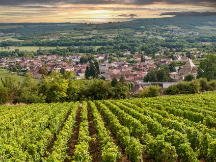
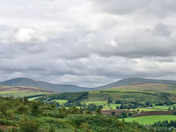
The Cross Borders Drove Road is an 84 km point-to-point trail in Scotland, linking West Lothian with the Scottish Borders. Usually walked in 5 days, it is a challenging Scotland’s Great Trail for confident hikers who can handle wet moorland, exposed hill crossings and some map-and-compass navigation. The route follows old cattle-droving roads from Little Vantage / Harperrig Reservoir to Hawick, passing West Linton, Peebles, Traquair, the Yarrow Valley and Bowhill.
Route Overview
The trail is linear, traditionally walked north to south from Little Vantage / Harperrig Reservoir on the A70 “Lang Whang” to Hawick. It can also be walked south to north. The line crosses the Pentland Hills via the Cauldstane Slap, then runs through West Linton, Romanno Bridge and Peebles before climbing towards Traquair and Minch Moor. The southern half follows the Yarrow Valley towards Bowhill / Newark Tower, Ashkirk and Hawick rather than Selkirk. Peebles is the main accommodation and resupply hub; the remote moorland sections have no facilities, so plan stages carefully. For another southern Scotland route, compare the Annandale Way; for a coastal contrast, see the Ayrshire Coastal Path.
Drovers, Reivers and the Old Roads South
From roughly the 16th to 19th century, these tracks formed part of Scotland’s cattle-droving network. Highland black cattle were driven south from the trysts at Crieff and Falkirk, over the Pentlands at the Cauldstane Slap, through West Linton and Peebles, then towards Hawick and English markets. Sheep also moved north in the opposite direction. The modern waymarked trail was created in 2005, linking surviving drove ways into one route and later becoming one of Scotland’s Great Trails.
Notable highlights
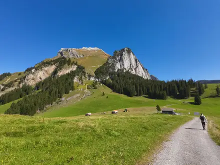
- The Cauldstane Slap (around 450 m): A historic moorland pass between East Cairn Hill and West Cairn Hill in the Pentlands. Also known as the “Thief’s Road”, it is one of the route’s most exposed and atmospheric droving sections.
- Minch Moor and the Southern Upland Way: The drove road briefly shares ground with the Southern Upland Way above Traquair, crossing high heathery ground at about 520 m on the route. Expect open views but also wet, exposed going.
- Peebles and the River Tweed: Peebles is the main town on the route and the key resupply and accommodation stop. Its position on the River Tweed makes it a natural halfway base.
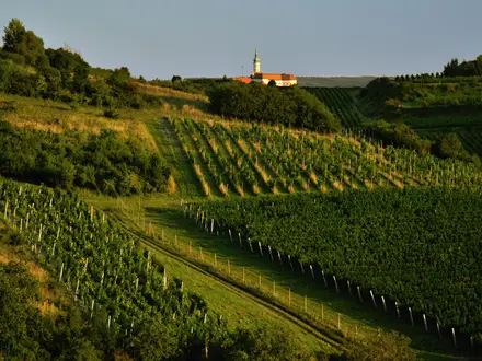
- Traquair House: Just off the route near the foot of Minch Moor, Traquair House is reputedly Scotland’s oldest continuously inhabited house. It makes a worthwhile cultural stop if your timing allows.
- Newark Tower, Bowhill: A ruined 15th-century tower house on the Buccleuch Bowhill estate in the Ettrick valley. It is a useful detour target on the southern half of the walk.
- Bull waymarks and droving heritage: The route is marked by round discs showing a bull, reflecting the cattle driven along these roads for centuries. They are helpful, but not a substitute for a map on open moorland.
Challenges to expect
Expect a real mix of grassy drove roads, forestry tracks, farm lanes, minor roads and boggy moorland. The Cauldstane Slap and Minch Moor are exposed, can be wet and indistinct, and need confident navigation in poor visibility. Resupply is limited between settlements, with Peebles the main hub. The route reaches about 537 m on Kirkhope Law, so weather can feel severe outside the main walking season.
HikeList Score
Cross Borders Drove Road scored 89/100 on HikeList's trail-quality metrics.
See score breakdownHide breakdown
- Ideal length 85
- Balanced challenge 84
- Scenery & wildness 98
- Varied terrain 100
- Accommodation 83
- Food & support 88
- Path quality 84
- Season flexibility 89
Computed from length, challenge, scenery & wildness, terrain variety, accommodation, food & support, path quality and season flexibility.
Show more data Show less
- Moorland
- Hills
- Forest
- River Valley
- Grass
- Dirt
- Gravel
- Paved
- Hotels
- Bed And Breakfasts
- Inns
- Family Friendly
- Dog Friendly On Leash
- Restrooms
- Non Potable Water Sources
- Established Campsites
- Shelters
- Picnic Areas
Download Our Full Guide to Cross Borders Drove Road FREE!
Get our comprehensive guide to this hike for free. Save it for later reading or print out at home.
Photos from hikers
Taken on the trail by people who've reviewed Cross Borders Drove Road.
Cross Borders Drove Road: The Complete Guide
 i
Image by photomic
i
Image by photomic The Cross Borders Drove Road is an 82 km point-to-point crossing from Little Vantage by Harperrig Reservoir to Hawick on the River Teviot. It follows old cattle-droving ways over the Pentlands, through the Tweed valley and across the Yarrow and Ettrick hills.
This is a quiet, practical hill route rather than a polished promenade. Expect grassy drove tracks, farm and estate lanes, forestry roads, boggy moorland and long views from exposed high ground such as the Cauldstane Slap, Kirkhope Law and the Minch Moor crossing.
The appeal is its combination of history and space. Bull waymarks nod to the cattle once driven over these roads, while places such as West Linton, Peebles, Traquair, Yarrowford, Bowhill and Hawick give the route its Borders shape.
It suits fit, self-reliant walkers who are comfortable with map-and-compass navigation and days with limited services. Waymarking is not something to depend on everywhere, and the high moorland sections can feel serious in poor visibility or rough weather.
This guide covers stages, daily planning, accommodation, food, transport, terrain and common mistakes.
Stage-by-Stage Guide
The five-stage split below suits a steady walker and keeps the hardest high ground manageable. Fit parties sometimes combine stages, but this route is not a simple low-level valley walk: the Cauldstane Slap, Kirkhope Law and Minch Moor sections all deserve full hill-walking judgement in poor weather.
Waymarking uses round bull discs, but it should not be treated as a substitute for navigation. Carry the relevant OS mapping, a compass and an offline route line, especially on the open moorland, around Peebles and on descents where markers can be sparse.
Stage 1: Little Vantage / Harperrig to West Linton — approx. 21 km
This is an immediate hill stage, leaving the A70 at Little Vantage near Harperrig Reservoir and climbing into the Pentlands rather than easing gently into the walk. The main feature is the Cauldstane Slap, the historic drove-road pass between East Cairn Hill and West Cairn Hill, at about 441 m.
Underfoot, expect grassy drove tracks, wet moorland and exposed upland going. The pass is one of the most atmospheric parts of the route, but it can feel bleak in wind, rain or low cloud, and visibility can deteriorate quickly on the rounded Pentland tops.
The route then works south towards Baddinsgill and onward to West Linton, a former droving village with strong historic links to sheep and cattle markets. West Linton is the first proper settlement on the route and a sensible overnight stop after the exposed opening crossing.
Do not rely on food or shop access between Little Vantage and West Linton. Start with enough food and water for the full stage; any water taken from burns or upland sources should be treated.
Accommodation is available in West Linton, but options are limited compared with Peebles or Hawick, so book ahead in busy walking periods. Wild camping is possible in Scotland under the Scottish Outdoor Access Code, provided it is done responsibly and away from houses, stock and enclosed fields.
The northern trailhead is at the Little Vantage car park on the A70 Lang Whang. There is no railway on the route; access to the start normally involves a bus or taxi from Edinburgh or Livingston, and current public transport times to Little Vantage should be checked before travelling. West Linton has bus links towards Edinburgh, making it one of the easier intermediate access points.
Navigation is most important on the moorland around the Cauldstane Slap. In poor visibility, stay disciplined with map and compass bearings rather than following faint trods or vehicle marks that may lead away from the drove road.
Stage 2: West Linton to Peebles — approx. 21 km
This stage moves from the Pentland fringe into the Tweed valley approach, passing Romanno Bridge before reaching Peebles. It is generally less high and exposed than the first day, but it is still a full-length stage with a mix of tracks, farm and estate lanes, minor roads and potentially muddy field or moorland sections.
The walking has a more settled feel, with the route linking old drove ways between villages and farmland rather than spending the whole day on open hill. Peebles is the major objective: it is the principal town on the route and the key resupply and accommodation hub roughly midway along the Cross Borders Drove Road.
Food and water are best planned around West Linton at the start and Peebles at the finish. Romanno Bridge is a useful place name for orientation, but services there should not be assumed; carry what is needed for the full day.
Peebles has the strongest range of accommodation and resupply on the route. This is the best place to restock, replace forgotten items, dry kit if necessary and reset before the higher southern half.
West Linton and Peebles are both served by buses from Edinburgh. This makes Stage 2 one of the more practical sections for walkers joining or leaving the route by public transport, although current timetables should still be checked before travelling.
Waymarking can be less obvious around Peebles, so do not switch off simply because the stage is approaching a town. The usual rural walking cautions apply: use gates properly, keep dogs under close control near livestock and expect short stretches on quiet roads or lanes.
Stage 3: Peebles to Traquair — approx. 14 km
This is the shortest stage in the five-day itinerary, but it includes the highest point of the whole route: Kirkhope Law, a grassy 537 m summit in the Manor Hills. The climb out from the Peebles area takes the route back into open hill country, with wide views over the Tweed and towards the Yarrow hills in clear weather.
The terrain is mainly hill track and grassy upland, with conditions becoming wet or indistinct after poor weather. Although the distance is modest, this is not a rest-day stroll; the height gain and exposure make it a proper hill section.
After Kirkhope Law the route continues towards Traquair, near the foot of the Minch Moor crossing. Traquair House lies just off the route and is a worthwhile cultural stop if timing and opening arrangements fit the day.
Peebles is the place to buy food before starting. Do not depend on finding supplies on the hill, and carry enough water for the crossing; any natural water should be treated.
Accommodation at Traquair itself is sparse, so many walkers use accommodation at or near Traquair and Innerleithen, or arrange a transfer if necessary. This should be booked before committing to the day’s finish point, especially in season.
Peebles is well placed for bus access. Public transport from the Traquair end is less straightforward than from the main towns, so onward buses or taxis should be checked before travelling.
Navigation matters on the open ground between Peebles and Traquair, particularly in mist. Kirkhope Law is the trail high point; the route later crosses the flank of Minch Moor, but it does not go to Minch Moor’s 567 m summit.
Stage 4: Traquair to Bowhill / Yarrowford area — approx. 13 km
This stage crosses another of the route’s serious upland sections, climbing above Traquair onto the flank of Minch Moor and briefly sharing ground with the Southern Upland Way. It is a short stage on paper, but the combination of height, exposure, heathery ground and forestry makes it one to treat with care.
The route crosses high, open terrain at about 520 m before descending towards Yarrowford and the Yarrow Water. In clear conditions this is one of the finest stretches of the southern half, with the drove road feeling remote and spacious above the Yarrow valley.
The later part of the stage enters the Yarrow and Bowhill area, with Newark Tower on the Bowhill estate a notable historic landmark nearby. Ground conditions vary between open moorland, forestry roads, tracks and valley routes, and wet weather can make the higher ground heavy going.
Carry food and water from the start. Services between Traquair and the Bowhill / Yarrowford area are limited, and water from upland or forestry sources should be treated.
Accommodation near the end of this stage is the awkward point in the standard five-day split. Options in the Bowhill / Yarrowford area are limited compared with Peebles, Innerleithen or Hawick, so book well ahead or arrange a taxi transfer to accommodation elsewhere.
Road access exists in the Yarrowford and Bowhill area, but public transport details are not as simple as at Peebles or Hawick. This should be checked before travelling, particularly if relying on a bus to reach accommodation or return to the route next morning.
Navigation can be testing around Minch Moor and on forestry sections. Forestry diversions in the Elibank and Traquair Forest area should be checked before setting out, and the high ground should be avoided in poor visibility if the party is not confident with map and compass.
Stage 5: Bowhill / Yarrowford area to Hawick — approx. 17 km
The final stage leaves the Yarrow and Bowhill area and works south-east towards Hawick, passing through the Ashkirk area before finishing in the Roxburghshire mill town on the River Teviot. It is lower than the Minch Moor day, but still long enough to require an early, organised start if public transport is booked at the far end.
Terrain is mixed: estate and farm tracks, quiet minor roads, lanes and softer rural paths. After the bigger hill crossings of the previous stages, the walking becomes more about linking Borders settlements and countryside than crossing open tops.
Newark Tower and the Bowhill estate area provide the main historic focus at the northern end of the stage. Hawick is the practical finish, with the best onward transport and town services at the southern end of the route.
Do not assume reliable food or shop access before Hawick. Ashkirk is an important waypoint, but services should be checked before relying on them; most walkers should carry lunch and enough water from the start of the stage.
Hawick has the strongest accommodation choice at the end of the walk and is the natural place to stay after finishing. It is also a good point for onward buses, with frequent connections towards Edinburgh and Carlisle; the Borders Railway terminus at Tweedbank/Galashiels can be reached by bus from Hawick.
Navigation is generally less committing than on the Cauldstane Slap or Minch Moor, but the route still passes through working farmland and estate ground where paths, tracks and gates can be confusing. Follow the mapped line carefully, respect livestock and keep to the right of way rather than drifting onto private estate roads that are not part of the trail.
Recommended Itinerary
The 5-day itinerary is the most workable standard plan for most independent walkers. It keeps the two main long approaches manageable, uses Peebles as the natural midway hub, and avoids forcing an overlong day across the higher Borders ground.
Daily distances are approximate. Accommodation location, route variants, forestry diversions and the exact line used through settlements can change totals, so check official mapping before booking.
Standard 5-day itinerary
| Day | From | To | Approx. distance | Why this stage makes sense | Services/accommodation notes |
|---|---|---|---|---|---|
| 1 | Little Vantage / Harperrig Reservoir | West Linton | 21 km | A strong opening stage over the Pentlands, taking in the Cauldstane Slap before descending to the first proper settlement. This is one of the more exposed days, so start early if weather or visibility is marginal. | Little Vantage is a remote A70 trailhead, so transport to the start must be planned carefully. West Linton has the first realistic overnight stop; book ahead in season. |
| 2 | West Linton | Peebles | 21 km | A full but logical day linking West Linton, Romanno Bridge and the Tweed-side town of Peebles. It positions you well before the higher Manor Hills section. | Peebles is the main accommodation, food and resupply hub on the route. This is the best place to restock properly before the sparser southern half. |
| 3 | Peebles | Traquair | 14 km | A shorter day on paper, but it includes the climb over Kirkhope Law, the high point of the trail at 537 m. Keeping this stage shorter gives useful margin for poor visibility or slower going on open hill ground. | Accommodation may be in the Traquair or Innerleithen area rather than exactly on the line of the route. Confirm the overnight location and any approach before committing. |
| 4 | Traquair | Bowhill / Yarrowford area | 13 km | This stage tackles the Minch Moor crossing and then drops towards Yarrow Water. It is not long, but the exposed moorland and possible forestry diversions make it a day where navigation matters. | This is the most awkward overnight in the standard split because services are sparse. Do not assume accommodation or food will be available at Bowhill or Yarrowford without booking; this should be checked before travelling. |
| 5 | Bowhill / Yarrowford area | Hawick | 17 km | A final Borders stage through the Yarrow and Ettrick country, passing the Bowhill / Newark area and Ashkirk before finishing in Hawick. | Hawick is the strongest end-point for accommodation and onward bus connections. If staying short of Hawick, check transport and accommodation carefully before travelling. |
Slower variant: 6 days with a Peebles break
This suits walkers who want more recovery time, prefer a less pressured crossing of the southern half, or want time for Peebles and the Traquair area. Because accommodation between the main settlements is sparse, the simplest slower version is usually the standard 5 walking days with an added night in Peebles rather than trying to create unsupported half-stages.
| Day | From | To | Approx. distance | Why this stage makes sense | Services/accommodation notes |
|---|---|---|---|---|---|
| 1 | Little Vantage / Harperrig Reservoir | West Linton | 21 km | Keeps the Pentland crossing as a single, self-contained day. | Arrange transport to Little Vantage in advance; book West Linton accommodation. |
| 2 | West Linton | Peebles | 21 km | Reaches the route’s main midway hub before the more remote southern stages. | Peebles is the best place for resupply and a second-night pause. |
| 3 | Peebles | Peebles | 0 km walking on the main route | A rest, resupply or weather-buffer day before Kirkhope Law and Minch Moor. | Useful if the forecast for the higher ground is poor. Accommodation should still be booked ahead. |
| 4 | Peebles | Traquair | 14 km | Allows the Kirkhope Law stage to be walked without rushing. | Check where the overnight accommodation sits relative to Traquair and the route. |
| 5 | Traquair | Bowhill / Yarrowford area | 13 km | Gives the Minch Moor crossing its own day. | This overnight must be arranged carefully; services are limited. |
| 6 | Bowhill / Yarrowford area | Hawick | 17 km | Leaves a moderate final day into Hawick. | Hawick has the best onward transport options at the southern end. |
A true slower walking split, with shorter distances each day, depends on pre-arranged accommodation or transport around places such as Baddinsgill, Romanno Bridge, Yarrowford, Bowhill or Ashkirk. This should be checked before travelling.
Faster variant: 3 days for fit, efficient walkers
A 3-day crossing is realistic only for strong hill walkers who can maintain pace over wet moorland, carry what they need between settlements, and navigate confidently if waymarking is sparse. It is not the best choice for a first multi-day hill route.
| Day | From | To | Approx. distance | Why this stage makes sense | Services/accommodation notes |
|---|---|---|---|---|---|
| 1 | Little Vantage / Harperrig Reservoir | West Linton | 21 km | Keeps the exposed Cauldstane Slap crossing separate from the very long Borders stages that follow. | West Linton is the practical first overnight. Check transport to the remote start before fixing the day. |
| 2 | West Linton | Traquair | Approx. 35 km by the standard-stage figures | Combines the West Linton–Peebles and Peebles–Traquair sections, using Peebles as a food stop rather than an overnight. This is a long day with the climb over Kirkhope Law late enough to matter. | Peebles is the key resupply point during the day. Overnight arrangements should be confirmed for Traquair or the Innerleithen area. |
| 3 | Traquair | Hawick | Approx. 30 km by the standard-stage figures | Combines Minch Moor, the Yarrow / Bowhill area and the approach to Hawick into one demanding final day. Start early and avoid committing to this in poor visibility or severe weather. | There are limited services before Hawick, so carry enough food and allow for a long day. Hawick is the practical finish for accommodation and onward buses. |
Planning the Route
The Cross Borders Drove Road needs more planning than its modest length suggests. The limiting factors are not mileage alone, but the spacing of accommodation, the exposed moorland crossings, and the fact that the route begins at a remote A70 trailhead rather than in a town.
Most walkers should plan around a 5-day itinerary. This gives sensible daily distances, uses the main settlements and valleys as anchors, and leaves more margin for poor visibility on the Cauldstane Slap, Kirkhope Law and Minch Moor sections.
Fit, experienced walkers often compress the route into 3 longer days, but that makes each day more exposed and leaves less room for transport delays, navigation errors or bad weather. A fast schedule suits strong hill walkers carrying light kit, not anyone depending on relaxed starts, pub meals and easy bail-outs.
Choosing a 3, 4 or 5-day schedule
| Schedule | Best for | Planning implications |
|---|---|---|
| 5 days | Most independent walkers | Fits the established Little Vantage/Harperrig to West Linton, West Linton to Peebles, Peebles to Traquair, Traquair to Bowhill/Yarrowford area, and Bowhill/Yarrowford area to Hawick pattern. Accommodation still needs booking carefully, especially outside Peebles. |
| 4 days | Strong walkers wanting shorter trip length without a full fastpack approach | Possible in principle, but less naturally shaped by the settlements. Expect at least one longer or more awkward day, and check accommodation and transport before fixing stages. |
| 3 days | Very fit, self-reliant hikers | Common among experienced walkers, but daily mileage is high and the route’s remote sections become more committing. Navigation, food carrying and weather windows matter more. |
The route is naturally dictated by settlement spacing. West Linton, Peebles and Hawick are the clearest overnight anchors, with Peebles the strongest resupply and accommodation hub around the midpoint. Traquair, Yarrowford and Bowhill can be useful for breaking the southern half, but accommodation and services are much more limited; this should be checked before travelling.
Accommodation strategy
Book accommodation before committing to a fixed itinerary. Hotels, inns, guesthouses and B&Bs are concentrated in West Linton, Peebles, Innerleithen and Hawick, with far fewer options on the remote moorland and valley sections between them.
Peebles is the most useful planning point. It is the main place to reset food supplies, sort kit problems and build in flexibility before the higher ground towards Kirkhope Law, Traquair and Minch Moor.
The southern half needs particular care. If staying around Traquair, Yarrowford, Bowhill or nearby settlements, check exact location, availability, food options and any transfer needs before booking the rest of the walk around it.
Wild camping is permitted under the Scottish Outdoor Access Code, which can make the route more flexible for experienced backpackers. It does not remove the need for careful planning: the high moorland is exposed, water should not be assumed safe untreated, and camping responsibly away from buildings, livestock and enclosed farmland is essential.
Food and water planning
Do not treat this as a route with daily resupply everywhere. West Linton, Peebles and Hawick are the main practical service points, and Peebles is the key midway hub. Between settlements, carry enough food for the full stage plus a reserve in case progress is slowed by weather or navigation.
Water planning is straightforward in the lower valleys but more serious on the open hill sections. Carry sufficient water for the Cauldstane Slap, Kirkhope Law and Minch Moor crossings, and treat or filter any natural water if using it.
Even on a 5-day schedule, snacks and lunch supplies should be bought ahead rather than assumed en route. Evening meals also need checking in smaller places, especially where accommodation is limited or seasonal.
Navigation and route-finding
The route is waymarked with round bull discs, but waymarking should not be treated as enough on its own. Some descents and areas around Peebles can be sparse or unclear, and the high moorland can become difficult to read in mist.
Carry proper OS mapping and a compass, and know how to use them. Relevant OS sheets include Landranger 65, 66, 72, 73 and 79, and Explorer 331, 336, 337, 338 and 344.
A GPS track or mapping app is useful backup, especially through forestry, farm tracks and open moor, but it should not replace map-and-compass navigation. Battery management matters on a multi-day route with long exposed sections.
Weather windows and exposed crossings
The Cauldstane Slap, Kirkhope Law and the Minch Moor crossing are the sections to plan around. They are not technically difficult in good conditions, but they are open, wet, high enough to catch bad weather, and more serious in poor visibility.
Check the forecast before leaving Little Vantage/Harperrig and again before committing to the Peebles–Traquair–Minch Moor part of the route. In winter storms or persistent poor visibility, the high moorland should be avoided.
Late spring, summer and early autumn are the most practical seasons. Even then, expect wet ground and sharp changes in conditions across the Pentlands and the Yarrow/Ettrick hills.
Transport planning
Transport is bus-based at both ends, with no railway on the route itself. The northern trailhead at Little Vantage is on the A70 near Harperrig Reservoir, so bus times or taxi arrangements need checking carefully before setting out.
West Linton, Peebles and Hawick are served by regular buses from Edinburgh, and Hawick has frequent Edinburgh and Carlisle connections. The closest railhead to the southern end is the Borders Railway terminus at Tweedbank/Galashiels, reached by bus from Hawick.
For section hiking, the easiest access points are the larger served settlements rather than the remote passes. West Linton, Peebles and Hawick make the most practical start or finish points; using Traquair, Yarrowford or Bowhill as section breaks may be possible, but local transport should be checked before travelling.
Shortening, extending and splitting the route
The route is point-to-point and does not lend itself to casual shortening once on the high ground. The best way to shorten the walk is to plan a section in advance between transport-served settlements, rather than expecting to leave the route easily from the moors.
Peebles is the natural place to split the trail into northern and southern halves. A northern section from Little Vantage/Harperrig to Peebles covers the Pentlands and Tweed approach; a southern section from Peebles to Hawick takes in Kirkhope Law, Traquair, Minch Moor, Yarrow Water, Bowhill and Ashkirk.
Extending the walk is possible only by linking with other local paths, heritage routes or the Southern Upland Way where the routes meet around Minch Moor. Any extension should be planned separately with current maps, accommodation and transport checked before relying on it.
Key checks before booking
- Bus times to Little Vantage on the A70 and onward connections from Hawick.
- Accommodation availability in West Linton, Peebles, Innerleithen, Hawick and any smaller overnight stop.
- Food options between Peebles, Traquair, Yarrowford/Bowhill and Hawick.
- Weather and visibility for the Cauldstane Slap, Kirkhope Law and Minch Moor sections.
- Current forestry diversions in the Elibank and Traquair Forest area.
- Up-to-date OS mapping or a reliable GPS file used alongside map and compass.
Towns, Villages and Overnight Stops
Accommodation and resupply are uneven on the Cross Borders Drove Road. West Linton, Peebles, the Innerleithen/Traquair area and Hawick are the realistic settlement-based overnight points; between them, the route crosses exposed hill ground, estate tracks and small Borders settlements where services should not be assumed.
Book accommodation ahead, especially in the smaller places. If relying on buses, current timetables should be checked before travelling, particularly for the remote start at Little Vantage and for onward travel between the Borders towns.
Little Vantage / Harperrig Reservoir
Little Vantage is the northern trailhead, beside the A70 “Lang Whang” just north of Harperrig Reservoir. It is a starting point rather than a village, and there should be no expectation of accommodation, food or resupply at the car park.
Most walkers will arrive by lift, taxi or bus connection from Edinburgh or Livingston, then start straight into the Pentland Hills crossing. Because the first practical overnight stop is West Linton, begin with enough food, water and foul-weather kit for a full exposed hill day.
Cauldstane Slap
The Cauldstane Slap is a high Pentland pass, not an overnight stop. It is one of the route’s key exposure points and sits between the Little Vantage start and the descent towards West Linton.
There are no services on the pass. In poor visibility or bad weather, this section needs proper navigation and a conservative approach to timing; do not plan around buying supplies or getting shelter here.
Baddinsgill
Baddinsgill sits on the northern half of the route after the Cauldstane Slap crossing and before West Linton. Treat it as a route landmark rather than a dependable service stop.
No reliable accommodation, shop or food information is available for route planning purposes here, so walkers should continue to West Linton unless a private arrangement has been made in advance. This should be checked before travelling.
West Linton
West Linton is the first proper settlement on the route when walking south from Little Vantage. It makes the natural first overnight stop on a five-day itinerary after the long opening stage over the Pentlands.
Accommodation is available in and around the village, but capacity is limited compared with larger Borders towns. Book ahead rather than assuming a same-day room will be available.
West Linton is also the first place where walkers can reasonably plan around food and local facilities, although opening hours and individual services should be checked before travelling. It has bus links with Edinburgh, making it a useful access or exit point for section walkers.
Romanno Bridge
Romanno Bridge lies between West Linton and Peebles on the second stage. It is useful as a progress marker on the way into the Tweed valley, but it should not be treated as a main resupply or overnight base without prior checks.
If splitting the route unusually, any accommodation, food or transport arrangements here need to be made in advance. Most walkers will continue to Peebles, which is far stronger for lodging, meals and supplies.
Peebles
Peebles is the main accommodation and resupply hub on the Cross Borders Drove Road. It sits on the River Tweed roughly midway through the route and is the best place to reset before the hillier southern half.
For most walkers, Peebles is the most practical overnight stop after West Linton. It has the broadest choice of accommodation on the route, plus the best chance to buy food, replace forgotten items, eat a proper meal and adjust plans if the weather is turning.
Peebles is served by regular buses from Edinburgh, so it is also the strongest mid-route access point for section hikers. If walking the route in three longer stages, Peebles is still the key logistical anchor.
Traquair
Traquair sits after the high crossing from Peebles over Kirkhope Law and before the climb towards Minch Moor. It is a logical short-stage overnight area on a five-day itinerary, especially for walkers who do not want to combine the Peebles hill crossing with the Minch Moor section.
Accommodation in the immediate Traquair area may be limited, but the wider Innerleithen/Traquair area has options compared with the surrounding hills. Book ahead, and do not leave this stop to chance in the main walking season.
Food and evening meal options should also be checked before committing to an overnight here. Traquair House is just off the route and can make this a worthwhile cultural pause, but walkers should plan the stop around practical lodging and food first.
Minch Moor Crossing
The Minch Moor crossing is not a settlement and has no services. The route climbs onto high, heathery, exposed ground above Traquair and briefly shares ground with the Southern Upland Way before dropping towards Yarrowford.
Do not plan to camp, resupply or find shelter here as part of a normal itinerary unless fully self-sufficient and operating within the Scottish Outdoor Access Code. Forestry diversions in the Elibank and Traquair Forest area should be checked before travelling.
Yarrowford
Yarrowford lies in the Yarrow valley after the Minch Moor crossing. It is an important point because it marks the return from high ground to lower valley walking, but it is not as strong a service centre as Peebles or Hawick.
Some itineraries aim for the Bowhill/Yarrowford area for the fourth night. Any accommodation or meal arrangements in this area should be booked and checked in advance, as services are sparse and may not suit a late arrival from the hills.
Bowhill / Newark
Bowhill and the Newark area sit in the Ettrick/Yarrow country on the southern half of the route. Newark Tower is a notable landmark, but this area should be treated cautiously for logistics.
The standard five-day outline uses the Bowhill/Yarrowford area as an overnight zone before the final walk to Hawick. That does not mean there is abundant accommodation on the line of the trail; arrange lodging, food and any transfers before setting out.
Ashkirk
Ashkirk lies between the Bowhill/Yarrowford area and Hawick on the final section. It is useful as a place-name and route marker on the way south, but it should not be relied on as a full resupply stop unless current services have been checked.
For most walkers, Ashkirk is passed through or near en route to Hawick rather than used as an overnight base. If planning a shorter final day or a bespoke itinerary, accommodation and transport here should be arranged in advance.
Hawick
Hawick is the southern finish of the Cross Borders Drove Road, on the River Teviot. It is the strongest end-point for accommodation, food and onward transport.
The town has a wider range of places to stay than the smaller rural stops, making it the sensible place to book a final night if public transport times do not line up with the finish. It is also the best southern-end location for a proper meal and post-walk resupply.
Hawick is a regional bus hub with frequent connections towards Edinburgh and Carlisle. The closest railhead for the southern end is via the Borders Railway at Tweedbank/Galashiels, reached by bus from Hawick; current bus and train times should be checked before travelling.
Getting to the Start
The Cross Borders Drove Road starts at Little Vantage car park on the A70 “Lang Whang”, just north of Harperrig Reservoir and south-west of Edinburgh. It is a remote roadside trailhead rather than a town start, so the final approach needs more planning than the rest of the public transport journey.
By train
There is no railway on the route itself. The nearest practical rail access for the northern start is via Edinburgh or Livingston, then onward by bus or taxi to Little Vantage on the A70.
For most walkers arriving from elsewhere in Scotland or the UK, Edinburgh is the simplest rail gateway because it has onward bus links towards West Linton, Peebles and the Scottish Borders. Livingston may be useful if arranging a taxi to the A70 start, but the exact connection to Little Vantage should be planned in advance.
Do not rely on turning up and finding an easy same-day connection to the trailhead. This should be checked before travelling.
By bus
The route is best treated as bus-based at both ends, but the exact northern trailhead is the awkward part. West Linton, Peebles and Hawick are served by regular buses from Edinburgh, while Little Vantage itself sits on the A70 beside Harperrig Reservoir, away from a main settlement.
A common approach is to travel by bus from Edinburgh towards the West Linton area, then use a taxi or an available local bus connection to reach Little Vantage if the timetable allows. Current bus times to the A70 start should be checked carefully before booking accommodation or fixing a start time.
If a bus does not stop conveniently at Little Vantage, a taxi from Edinburgh, Livingston or a nearby Borders settlement may be the most practical way to begin. Pre-booking is strongly advised, especially for an early start before the first long stage over the Pentlands to West Linton.
By car
The northern trailhead is at Little Vantage car park on the A70, immediately north of Harperrig Reservoir. This makes drop-off by car straightforward, but using a private car for the whole walk is less convenient because the route is point-to-point and finishes in Hawick.
If leaving a vehicle, do not assume that Little Vantage is suitable for multi-day parking. Long-stay parking arrangements, security and any local restrictions should be checked before travelling.
A more practical option is often to arrange a lift or taxi to the start, then return from Hawick by bus at the end of the walk. Hawick is a strong regional bus hub, with frequent connections towards Edinburgh and Carlisle.
From the nearest airport
For walkers flying in, Edinburgh is the most practical air gateway for the northern end of the route. From there, continue by public transport towards Edinburgh city connections or Livingston, then arrange onward bus or taxi travel to Little Vantage.
The final leg to the A70 start is the key detail to solve in advance. This should be checked before travelling, particularly for weekend, evening or early-morning arrivals.
Where to stay before starting
There is no settlement at Little Vantage itself, so overnight options are better planned in a nearby transport hub or trail settlement. Edinburgh and Livingston are practical for rail access and taxi arrangements, while West Linton is the first proper route village and has accommodation concentrated around the northern part of the trail.
Staying in West Linton before starting can work if a taxi or bus connection to Little Vantage is arranged for the morning, allowing the first walking day to follow the drove road back over the Cauldstane Slap and down to West Linton. Accommodation in smaller Borders settlements should be booked ahead in season.
Wherever the pre-walk night is spent, aim to reach Little Vantage early enough for the exposed Pentland crossing. The first stage is not technically complex in good conditions, but poor visibility, wind or late starts can make the Cauldstane Slap a serious opening day.
Getting Home from the Finish
By train
Hawick does not have a railway station, so leaving by train means taking a bus or taxi out of town first. The closest railhead for the southern end of the route is the Borders Railway at Tweedbank/Galashiels, reached by bus from Hawick.
For many walkers, the simplest rail plan is therefore: finish in Hawick, bus to Tweedbank or Galashiels, then continue by train. Timetables and connections should be checked before travelling, especially if finishing late in the afternoon after the final section from the Bowhill / Yarrowford area.
By bus
Hawick is the best-served transport point on the whole route and is a strong regional bus hub. Regular buses connect Hawick with Edinburgh and Carlisle, giving useful onward options north, south and into the wider UK transport network.
Bus travel is the most practical default for this trail because there is no railway on the route itself. Current bus times should be checked before booking accommodation or onward trains, as evening and weekend services may affect whether it is sensible to travel on the same day as finishing.
If the final day runs long, staying in Hawick is usually safer than relying on a tight onward connection. The last stage includes rural ground before reaching town, and poor weather, tired legs or navigation delays can easily push arrival later than planned.
By car/taxi
A taxi can be useful for a transfer from Hawick to a railhead, accommodation elsewhere in the Borders, or a parked vehicle. Rural taxi availability should not be assumed at short notice; book ahead where possible, particularly for evenings, Sundays or public holidays.
Using a car for this point-to-point walk needs planning because the start is far to the north at Little Vantage / Harperrig Reservoir on the A70, while the finish is in Hawick. If leaving a vehicle at either end, arrange the retrieval transfer in advance rather than trying to solve it after finishing.
From the nearest airport
There is no airport at the finish. For flights, plan first around the public transport exit from Hawick, most likely by bus towards Edinburgh or Carlisle, then connect onward from there.
Airport transfer times, evening connections and any required changes should be checked before travelling. Avoid booking a tight same-day flight after the final walking day unless the bus and onward travel times line up comfortably.
Where to stay at the finish
Hawick has hotels, inns, guesthouses and B&Bs, making it the logical place to stop at the end of the Cross Borders Drove Road. It is a much more practical overnight base than trying to push straight on if arrival is late or the weather has slowed progress.
Book ahead in busy periods, especially if walking over weekends or during the main summer season. Staying overnight also gives more flexibility for bus or rail connections the following morning.
Which Direction Should You Walk?
The standard and most practical direction is north to south: Little Vantage / Harperrig Reservoir to Hawick. This is the way the route is usually presented, and it gives a cleaner finish in a proper Borders town rather than at a remote A70 car park.
The reverse is entirely possible, but it suits walkers with a specific transport plan, accommodation bookings that work better south-to-north, or a desire to finish over the Pentlands at the Cauldstane Slap.
North to south: Little Vantage to Hawick
Starting at Little Vantage puts the logistics pressure at the beginning. The northern trailhead is remote, on the A70 beside Harperrig Reservoir, so bus times or a taxi connection from Edinburgh/Livingston need to be planned carefully. This should be checked before travelling.
Once underway, the route quickly commits you to the Pentland Hills and the Cauldstane Slap, so the first day is not a gentle introductory stage. In poor visibility or bad weather, this is a serious opening crossing and should not be treated casually.
The accommodation and resupply flow works well in this direction. West Linton comes after the first major hill section, Peebles is reached roughly midway as the main hub, and the southern half then links Traquair, the Minch Moor crossing, Yarrowford/Bowhill and Hawick.
The finish is the main advantage. Hawick is a strong regional bus hub with onward connections towards Edinburgh and Carlisle, and finishing in a town on the River Teviot is far more practical than ending tired at Little Vantage with a fixed bus or taxi to catch.
South to north: Hawick to Little Vantage
Walking from Hawick makes the start easier to arrange because Hawick has better public transport than Little Vantage. It can also be a good option for walkers who want the psychological pull of finishing with the Pentland crossing and the view back towards Harperrig Reservoir.
The drawback is the final day. A northbound finish at Little Vantage leaves you at a remote roadside trailhead, not a settlement, so onward transport must be arranged precisely. This is the main reason the reverse direction is less convenient for most independent walkers.
Accommodation can also feel less forgiving in reverse. The first overnight stop options after leaving Hawick are in the sparser southern section around Ashkirk, Bowhill/Yarrowford and the Yarrow/Ettrick country, before the route reaches the better-served Peebles area. Book ahead rather than assuming availability in the smaller places.
Climbs, weather and navigation
Neither direction makes the Cross Borders Drove Road easy. The key high sections — the Cauldstane Slap, Kirkhope Law and the Minch Moor crossing — remain exposed, wet in places and potentially indistinct whichever way they are walked.
Direction should not be chosen on the assumption of helpful wind. Forecast, visibility and ground conditions matter more than northbound versus southbound, especially on the Pentlands and the Minch Moor / Traquair Forest section. Check the weather before committing to the high ground.
Navigation demands are also similar both ways. The route is waymarked with bull discs, but waymarking can be sparse or absent in places, including some descents and around Peebles, so OS mapping and compass skills are still essential.
Recommendation
For most walkers, walk north to south from Little Vantage / Harperrig Reservoir to Hawick. It follows the standard line, gives a logical progression through West Linton and Peebles, and finishes with the best transport and town services at Hawick.
Choose the reverse only if the transport works better for your itinerary or if accommodation availability makes it the more practical plan. In that case, arrange the Little Vantage finish before setting off, rather than leaving it to solve on the final day.
Accommodation Along the Route
Accommodation on the Cross Borders Drove Road is workable, but it is not evenly spaced. The practical overnight bases are West Linton, Peebles, the Traquair / Innerleithen area and Hawick, with Peebles the strongest midway hub for beds, food and resupply.
The awkward sections are the open moorland crossings and the southern Borders valleys, where settlements are small and accommodation is sparse. Walkers planning a fixed 5-day itinerary should book every night before setting off, especially in late spring, summer, early autumn, weekends and holiday periods.
| Place | Accommodation level | Best for | Notes |
|---|---|---|---|
| Little Vantage / Harperrig Reservoir | None | Starting the route only | The northern trailhead is a remote car park on the A70. Do not plan to stay here unless wild camping nearby under the Scottish Outdoor Access Code is part of the plan. |
| West Linton | Limited | First overnight stop after the Cauldstane Slap | A useful village stop after the exposed Pentland crossing. Beds should be booked ahead, as choice is not extensive. |
| Romanno Bridge | Limited | Possible short-stage adjustment | Useful only if it fits a customised itinerary. Accommodation and services should be checked before travelling. |
| Peebles | Good | Main accommodation and resupply hub | The best place on the route for choice of hotels, inns, guesthouses and B&Bs. A sensible place for a rest, resupply or itinerary reset. |
| Traquair / Innerleithen area | Good | Overnight before or after the Minch Moor crossing | Traquair is close to the route, while Innerleithen is one of the stronger accommodation bases in this part of the Tweed valley. Book ahead if relying on a specific stop. |
| Yarrowford / Bowhill area | Limited | Breaking the southern half into manageable days | Accommodation is sparse around the Yarrow valley and Bowhill section. This is one of the key places to arrange beds, taxi transfers or a camping plan before starting. |
| Ashkirk | Limited | Possible final-stage adjustment | A small settlement before Hawick. Treat it as an option only after checking current accommodation availability. |
| Hawick | Good | Finish of the route | The strongest accommodation base at the southern end, with onward bus connections. Useful for a final night before travelling home. |
Best overnight stops
For a steady 5-day walk, the natural overnight pattern is West Linton, Peebles, Traquair or the Innerleithen area, then somewhere around Yarrowford or Bowhill before finishing in Hawick. This keeps the harder crossings over the Cauldstane Slap, Kirkhope Law and Minch Moor separated by proper valley stops.
Fit walkers compressing the route into 3 longer stages will usually still need to anchor the plan around the same accommodation centres. Peebles is the obvious midpoint, while the final third needs more care because the Yarrowford, Bowhill and Ashkirk area has fewer straightforward overnight options than the Tweed valley towns.
Booking strategy
Book West Linton, Traquair / Innerleithen and the Yarrowford / Bowhill area before committing to dates. Peebles and Hawick have better choice, but they are still worth booking ahead in the main walking season and on busy weekends.
The most common planning mistake is assuming that every named village on the map has multiple walker-friendly beds. On this route, the gaps between accommodation are part of the challenge, especially once away from Peebles and the Tweed valley.
Inn-to-inn walking, camping and transfers
The Cross Borders Drove Road can work as an inn-to-inn walk, but it is less simple than routes with accommodation in every village. It suits walkers who are happy to plan around a few fixed accommodation hubs rather than arrive and look for a room each evening.
Wild camping is permitted in Scotland when done responsibly under the Scottish Outdoor Access Code. This can solve some awkward spacing, particularly near remote moorland sections, but campers need to be fully self-sufficient and prepared for exposed, wet ground and poor visibility.
Pre-booked taxi transfers can help bridge awkward accommodation gaps, especially around the southern half of the route. Availability, pick-up points and prices should be checked before travelling.
Do not assume a dedicated luggage-transfer service is available for this trail. If baggage transfer is essential, this should be checked before booking accommodation.
Camping and Wild Camping
Formal campsites
Do not plan this route around a reliable chain of on-trail campsites. The accommodation pattern is sparse, with most services concentrated in West Linton, Peebles, Innerleithen, Traquair and Hawick, and long moorland gaps between them.
If using formal campsites, treat them as something to arrange separately around the main settlements rather than assuming there will be a pitch at the end of each stage. Availability, opening dates and whether walkers are accepted should be checked before travelling.
Peebles is the most useful midway hub for resupply and accommodation planning. Hawick is the strongest end-point for onward transport, but campsite availability in or near the town should still be checked in advance.
Wild camping on the route
Wild camping is permitted in Scotland when done responsibly under the Scottish Outdoor Access Code. On the Cross Borders Drove Road, it can be a practical option because the route crosses long, quiet sections of open moorland where formal accommodation is limited.
The route suits experienced, self-reliant campers rather than first-time backpackers. The Cauldstane Slap, the Manor Hills around Kirkhope Law and the Minch Moor crossing are exposed, wet and can be indistinct in poor visibility, so camp plans must be flexible and weather-led.
A good wild camp on this route means a small tent, a short stay, a discreet pitch and no trace left behind. Avoid enclosed fields, crops, livestock areas, gardens, buildings, farmyards and places where camping would obstruct estate, forestry or farming work.
Where camping is most realistic
The high moorland sections give the best sense of remoteness but are not automatically the best places to sleep. Wind exposure, boggy ground and poor visibility can make the Cauldstane Slap and Minch Moor poor choices in unsettled weather.
Lower ground near the Tweed, Yarrow and Ettrick valleys is generally more practical for finding shelter and managing water, but it also brings more farms, estates, roads and settled land. In these areas, extra care is needed to choose lawful, discreet pitches well away from houses, stock and working ground.
The route’s natural camping logic is to avoid forcing a camp exactly on the named stage ends. A flexible itinerary works better: carry enough food to stop early or continue over a pass if the weather, ground or livestock make a planned pitch unsuitable.
Water planning
Do not assume reliable treated water between settlements. West Linton, Peebles and Hawick are the key places to reset food and water plans, with Peebles the main midway hub.
The route passes named water features and valleys including Harperrig Reservoir, the River Tweed, Yarrow Water and the Ettrick/Yarrow country, but upland water can be boggy, peaty or affected by livestock and land use. All wild water should be filtered, purified or boiled.
Carry enough water for the exposed crossings, especially the Cauldstane Slap, the Manor Hills and the Minch Moor section. In dry spells, do not rely on small upland burns being usable.
Stoves, fires and impact
Use a camping stove rather than an open fire. Open fires are a poor fit for this route’s moorland, forestry and estate ground, and are especially inappropriate in dry, windy or peaty conditions.
Leave No Trace matters here because much of the route is quiet and lightly serviced. Pack out all litter, food waste and hygiene products, camp on durable ground where possible, and move on if a pitch would damage vegetation or disturb livestock.
Human waste should be dealt with well away from paths, watercourses and grazing areas. In busy or sensitive areas near settlements, carry waste out where that is the responsible option.
Seasonal considerations
Late spring, summer and early autumn are the most realistic camping seasons. Winter storms, short daylight and poor visibility make the high moorland crossings significantly more serious.
Midges and ticks can be an issue in Scotland during warmer months, particularly around damp vegetation and sheltered valleys. Long trousers, tick checks and a midge headnet are sensible additions for campers.
Before committing to a wild-camping itinerary, check the forecast for the Pentland Hills, the Manor Hills and Minch Moor. Also check for any forestry diversions around the Minch Moor, Elibank and Traquair Forest section before travelling.
Food, Water and Resupply
Food planning is a real part of this route. The Cross Borders Drove Road crosses several quiet, exposed sections where there are no reliable on-trail services, especially over the Cauldstane Slap, between Peebles and Traquair, and across Minch Moor towards Yarrowford.
Peebles is the main resupply point roughly midway along the trail and should be treated as the best place to restock properly. West Linton and Hawick are also useful settlement stops, but rural opening hours, Sunday trading and seasonal changes can affect smaller places, so shop and meal options should be checked before travelling.
Food strategy
Start from Little Vantage / Harperrig Reservoir with the food needed for the first day already packed. The northern trailhead is a remote A70 car park area, not a place to depend on for supplies.
For a steady 5-day itinerary, carry at least a full day of walking food between overnight stops, plus an emergency meal or high-calorie reserve. Fit hikers compressing the route into 3 longer stages should carry more, as long days reduce the margin for detouring into settlements or reaching food before closing time.
Peebles is the sensible place to buy the heaviest resupply: lunches, snacks, stove food if camping, and any items needed for the more remote southern half. Do not assume meaningful food availability at Romanno Bridge, Traquair, Yarrowford, Bowhill or Ashkirk without checking current local options in advance.
If staying in hotels, inns, guesthouses or B&Bs, ask when booking whether evening meals, packed lunches or nearby food options are available. This matters particularly in the smaller settlements and in the Bowhill / Yarrowford area, where services are sparse.
Water strategy
Carry enough water to complete each high or remote section without relying on an untreated refill. A typical load of around 1.5–2 litres is sensible in cool conditions, with more needed in warm weather, for fast walkers covering longer stages, or if camping dry.
There are rivers and upland watercourses in the wider landscape, including the River Tweed, Yarrow Water and burns on the moorland sections, but natural water should be filtered, treated or boiled. Livestock, forestry, peat, farmland and estate land all make untreated water a poor assumption.
The exposed crossings over the Cauldstane Slap and Minch Moor are not places to run short. Fill bottles before leaving West Linton, Peebles or any booked accommodation, and treat cafés, pubs and accommodation taps as planned refill points only where opening hours or access are known.
Section-by-section resupply table
| Section | Food availability | Water availability | Notes |
|---|---|---|---|
| Little Vantage / Harperrig Reservoir to West Linton | None to rely on at the start or on the moorland crossing; carry the day’s food from before arrival. | Start with full bottles; natural upland water may require treatment and should not be assumed. | The Cauldstane Slap is exposed and remote. There is no useful resupply until West Linton. |
| West Linton to Peebles | Limited village-level resupply at West Linton may be possible, but check opening times; Peebles is the main target for proper resupply. | Refill before leaving West Linton; use treated natural water only if needed. | Do not rely on Romanno Bridge for food unless a specific stop has been checked before travelling. |
| Peebles to Traquair | Peebles is the best place on the whole route to buy food for the next stages. Traquair should not be treated as a guaranteed resupply point. | Fill fully in Peebles before climbing towards the Manor Hills and Kirkhope Law. Natural water should be treated. | This is a short stage on a 5-day schedule, but it crosses high ground and should still be treated as self-sufficient hill walking. |
| Traquair to Yarrowford / Bowhill area | Very limited; carry food from Peebles or from booked accommodation. | Refill before leaving accommodation. Moorland or forestry water should be filtered, treated or boiled. | The Minch Moor crossing is one of the key remote sections. Check any local meal options before committing to an overnight stop. |
| Yarrowford / Bowhill area to Hawick | Sparse until Hawick; carry breakfast, lunch and snacks unless food has been arranged with accommodation. | Refill before setting out; natural water in the Yarrow / Ettrick country should be treated. | Hawick is the end point and the next strong service hub. |
Practical resupply tips
Book accommodation with food logistics in mind, not just distance. In the smaller places, a bed without an evening meal or nearby shop can leave a long hungry gap unless supplies have been carried from Peebles or West Linton.
Carry lightweight backup food that does not need cooking: oat bars, nuts, dried fruit, wraps, cheese, cured meat or similar hill food. If camping, carry stove fuel and meals from the larger towns rather than expecting to buy them in the valleys.
Rural Borders businesses can keep shorter hours than urban walkers expect, and some may close on certain weekdays or Sundays. Confirm current prices, opening times and packed-lunch availability before booking or setting off.
Terrain, Conditions and Difficulty in Practice
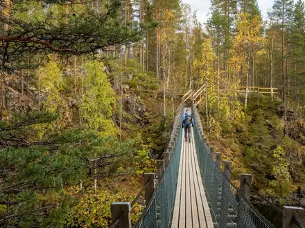
The Cross Borders Drove Road is hard less because of technical ground and more because of sustained upland exposure, long distances between services and the need to navigate confidently when the waymarks thin out. Much of the walking is on old drove roads, grassy hill tracks, forestry roads, farm and estate lanes and quiet minor roads, but the high moorland sections can be wet, vague and tiring underfoot.
There is no scrambling and little that would be considered rocky or technical by mountain standards. The practical challenge is keeping a steady pace over 82 km of rolling ground with around 2,260 m of ascent, while carrying enough food, waterproofs and navigation equipment for remote hill sections.
Underfoot: what the route actually feels like
Expect a genuine mix rather than one consistent path type. Lower sections near West Linton, Romanno Bridge, Peebles, Yarrowford, Bowhill, Ashkirk and Hawick use gentler tracks, lanes and minor roads, which generally make for faster walking but can feel hard on tired feet.
The upland parts are slower. Grassy drove tracks can be soft, rutted or boggy after rain, and open moorland crossings may have indistinct lines where the ground is wet or the path has spread out. Waterproof boots or trail shoes with very good grip are more useful here than lightweight road-style footwear.
Forestry roads occur on parts of the southern half, particularly around the Minch Moor / Elibank and Traquair Forest area. Forestry operations can lead to temporary diversions, so this should be checked before travelling.
The main hard sections
| Section | Terrain and difficulty in practice |
|---|---|
| Little Vantage / Harperrig Reservoir to West Linton | The first major test is the climb over the Pentlands via the Cauldstane Slap, around 441 m. This is exposed hill ground between East Cairn Hill and West Cairn Hill, with weather and visibility often more important than the gradient itself. Wet grass, wind and poor way definition can make this section feel much harder than it looks on a map. |
| West Linton to Peebles | Generally a less severe day underfoot, with a mixture of drove-road lines, farm and estate tracks, lanes and quieter road sections via the country between West Linton, Romanno Bridge and Peebles. The difficulty here is more cumulative distance than technical terrain. |
| Peebles to Traquair | The route climbs out of the Tweed valley into the Manor Hills and reaches Kirkhope Law, the high point of the trail at 537 m. This is grassy hill country rather than rocky mountain terrain, but it is open, exposed and slow in bad weather. |
| Traquair to Yarrowford / Bowhill area | The climb onto the flank of Minch Moor is one of the key upland crossings. The route does not summit Minch Moor itself, but it crosses high ground at about 520 m and briefly shares terrain with the Southern Upland Way. Expect heathery, exposed conditions, with navigation becoming serious in mist. |
| Yarrowford / Bowhill area to Hawick | The final section is generally lower and more mixed, using valley, estate, farm and minor-road terrain through the Yarrow and Ettrick country towards Hawick. It is still rolling walking rather than an easy towpath finish, and tired legs can make the lanes feel longer than expected. |
Exposure, weather and navigation
The Cauldstane Slap, Kirkhope Law and the Minch Moor crossing are the sections where the route becomes a proper hill walk. In clear, settled weather the gradients are manageable for a fit walker; in wind, rain or low cloud they can become slow, cold and navigationally demanding.
Waymarking uses round bull discs, but it should not be treated as the sole navigation system. Sparse or missing waymarks can be an issue on some descents and around Peebles, so OS mapping and a compass are essential, with GPS useful as a backup rather than a replacement.
The route has several broad moorland areas where a wrong line can waste time and energy. In poor visibility, avoid relying on distant landmarks or fence lines unless they are clearly matched to the map.
Mud, bog and wet ground
Wet ground is one of the defining practical difficulties of the Cross Borders Drove Road. The boggiest and slowest going is most likely on the open moorland crossings, especially after prolonged rain and outside the driest summer periods.
The old drove-road surfaces can hold water in ruts and hollows. Even where the route is not steep, repeated soft ground makes the walking more tiring and can reduce daily pace significantly.
Lower valley sections beside the Tweed, Yarrow and Ettrick country are usually gentler, but they should not be assumed to be dry. Farm tracks, estate lanes and field-edge paths can still be muddy after rain.
Roads, farms, gates and livestock
Road walking is part of the route, mainly on quiet minor roads and lanes rather than major roads. These sections are useful for pace but require normal care with traffic, especially where verges are narrow or visibility is limited.
The route crosses working rural and estate landscapes, so expect gates and stock boundaries on farm and hill sections. Leave gates as found, keep dogs under close control and give livestock plenty of space, particularly in lambing and calving periods.
No special technical obstacle such as scrambling, river fording or tidal timing defines this route. The access challenges are the ordinary but important ones of rural Scotland: wet ground, gates, estate tracks, forestry operations and remote hills.
Seasonal conditions
Late spring, summer and early autumn are the most reliable seasons for the route. Longer daylight helps on the exposed upland stages, and accommodation and transport planning is simpler when there is more margin for delays.
Winter changes the nature of the walk. The high moorland is best avoided in winter storms and poor visibility unless equipped and experienced for winter hill navigation. Snow, frozen ground, wind chill and short daylight can make the Cauldstane Slap and Minch Moor crossings serious undertakings.
After heavy rain at any time of year, plan for slower progress on the grassy and boggy sections. In hot summer weather, the exposed hills offer little shelter, so water planning matters even though the route is in a wet part of Scotland.
What makes it easier or harder
The route becomes much easier with a conservative schedule, early starts on the high days and accommodation booked in the main settlements, especially West Linton, Peebles, Innerleithen / Traquair area and Hawick. Peebles is the main midway hub and the most useful point for resupply.
It becomes harder if walked as three long stages, in poor visibility, or with a heavy pack between limited resupply points. The historic drove roads are generally well graded, but the combination of distance, exposure and wet moorland means this is still a route for experienced, self-reliant hill walkers rather than a casual low-level trail.
Weather and Best Time to Walk
The best window for the Cross Borders Drove Road is late spring, summer and early autumn, when daylight is longer and the high moorland crossings are most likely to be manageable. The route is not technically high by Scottish standards, but the Cauldstane Slap, Kirkhope Law and the Minch Moor crossing are exposed enough for wind, rain and low cloud to make navigation and progress significantly harder.
This is a route to plan around visibility and wind, not just temperature. Several sections cross open, boggy moorland where the line can feel indistinct, and waymarking should not be relied on as the only means of navigation. Check the mountain weather forecast before committing to the Pentland Hills and Minch Moor sections.
Best months
| Season | Walking conditions | Practical notes |
|---|---|---|
| Late spring | Often one of the better periods: improving daylight, fresh ground conditions, and a good balance between weather and accommodation demand. | Still expect wet moorland and cold wind on the high ground. Carry full waterproofs and warm layers. |
| Summer | Long daylight makes the longer stages easier to manage, especially if walking the route in 3–4 days. | Accommodation in West Linton, Peebles, Innerleithen/Traquair area and Hawick should be booked ahead. Wet, windy hill days are still possible. |
| Early autumn | Good for quieter walking and clear hill days, with the Borders moorland often at its most atmospheric. | Daylight shortens quickly, so avoid over-ambitious stages unless fitness and navigation are strong. Check forecasts carefully before high crossings. |
| Winter | Possible only for suitably experienced, self-reliant hill walkers in good conditions. | The route is best avoided in winter storms, snow, ice, poor visibility or very short daylight windows. Some sections would become serious navigation undertakings. |
Weather hazards that matter on this route
Low cloud and fog are the main navigational hazards. The route crosses broad, grassy and heathery uplands rather than sharp ridgelines, so in poor visibility it can be easy to drift off the intended line, particularly around the Cauldstane Slap and Minch Moor.
Wind exposure is also a serious consideration. Much of the route’s character comes from open drove roads across high ground, but those same sections give little shelter in bad weather. Strong winds can make the high crossings tiring and slow, especially with a multi-day pack.
Rain and saturated ground affect pace more than difficulty on paper suggests. The route uses old drove tracks, forestry roads, farm lanes and minor roads, but also has long stretches of open, boggy moorland. After wet weather, expect slower going, wet feet and more attention needed to keep to the best line.
Snow and ice are not compatible with a casual long-distance walk here. The high point is Kirkhope Law at 537 m, with other exposed crossings around the Cauldstane Slap and Minch Moor, so winter conditions can turn the route from a hill walk into a serious navigation and safety problem.
Daylight and stage planning
Summer daylight gives useful margin on the longer 21 km stages between Little Vantage and West Linton and between West Linton and Peebles. It also makes a 3-day or 4-day itinerary more realistic for fit walkers.
In early autumn and especially winter, the same distances need more conservative planning. Start early, allow for slower moorland ground, and avoid beginning the exposed crossings late in the day.
Trail surface by season
In dry spells, the old drove roads and estate tracks can make for efficient walking. The lower valley sections beside the Tweed, Yarrow Water and Ettrick country are generally less exposed than the hill crossings, although they can still be wet underfoot.
After prolonged rain, the open moorland sections become the slowest parts of the route. Expect boggy ground, indistinct lines and more effort on the climbs and descents around the Pentlands, the Manor Hills and Minch Moor.
Accommodation and seasonal availability
Peebles is the main midway accommodation and resupply hub, while West Linton, Innerleithen/Traquair area and Hawick are the key settlement options for most itineraries. Smaller places have limited beds, so summer and early autumn bookings should be made ahead.
Wild camping is permitted under the Scottish Outdoor Access Code, but weather exposure should drive camp planning. The high moorland is not a place to rely on if strong wind, heavy rain or poor visibility is forecast.
Is the route realistic in winter?
For most walkers, winter is not the right season for the Cross Borders Drove Road. Short daylight, wet or frozen ground, strong winds and low cloud all work against a safe and enjoyable crossing.
Experienced winter hill walkers may find suitable weather windows, but only with full navigation skills, appropriate clothing and the flexibility to change plans. The forecast for the Cauldstane Slap and Minch Moor sections should be checked before travelling and again before setting out.
Safety Notes
The Cross Borders Drove Road is not technically difficult in a scrambling sense, but it is a serious long-distance hill walk. The main safety issues are exposure, navigation, remoteness and the long gaps between reliable services, especially on the Cauldstane Slap, Kirkhope Law and Minch Moor sections.
Emergency help
In an emergency in the UK, call 999 or 112 and ask for Police, then Mountain Rescue if the incident is on the hill. Give a clear location using a grid reference, GPS coordinates, nearby landmarks and the name of the route.
Mobile signal should not be relied on across the open moorland, forestry and hill sections. Carry a paper OS map and compass, and know how to use them; a phone GPS is useful, but it should not be the only navigation tool.
Navigation and waymarking
The route is waymarked with round bull discs, but waymarking can be sparse or absent in places, including around Peebles and on some descents. In poor visibility the high, grassy and boggy sections can be hard to interpret on the ground.
The essential navigation areas are:
- Little Vantage / Harperrig Reservoir to West Linton, especially the crossing of the Cauldstane Slap.
- Peebles to Traquair, including the high ground around Kirkhope Law, the route’s highest point.
- Traquair to Yarrowford, including the exposed crossing on the flank of Minch Moor.
- Forestry areas around Elibank and Traquair Forest, where diversions may affect the line. This should be checked before travelling.
Relevant OS mapping includes Landranger 65, 66, 72, 73 and 79, and Explorer 331, 336, 337, 338 and 344.
Weather and exposure
The Pentland Hills, Manor Hills and Minch Moor crossings are open and exposed. Wind, rain and low cloud can make progress slow and navigation demanding, even though the hills are modest in height.
Carry full waterproofs, warm layers, hat and gloves outside high summer, and enough food to cope with a delay. In hot weather, the open moorland gives little shelter, so sun protection and sufficient water are just as important.
The high moorland is best avoided in winter storms and poor visibility unless you are equipped and experienced for winter hill conditions.
Water, boggy ground and rivers
Expect wet and boggy going on parts of the moorland, particularly after rain. Waterproof boots or trail shoes suited to saturated ground are more appropriate than lightweight urban footwear.
The route passes Harperrig Reservoir and follows or approaches rivers and valleys including the Tweed, Yarrow, Ettrick and Teviot. Keep clear of steep, slippery banks, take care near fast or high water after rain, and do not rely on untreated surface water unless you are carrying a suitable filter or purification method.
Roads, farms and livestock
The route includes quiet minor roads, farm and estate lanes, and the start is beside the A70 at Little Vantage. Walk facing oncoming traffic where there is no pavement, use verges carefully, and make yourself visible in poor light or bad weather.
This is working farming and estate country. Leave gates as found, give livestock plenty of space, and be especially cautious around cattle, sheep with lambs and farm machinery. Dogs should be kept under close control and on a lead where livestock are present.
Solo walking
Solo walkers should be comfortable with independent navigation and self-rescue decisions. Leave a route plan with someone reliable, agree check-in times, and make sure that person knows when to raise the alarm if contact is missed.
The long gaps between settlements mean that a minor problem — a twisted ankle, missed turn or late start — can become serious if you are short of food, daylight or warm clothing.
Before setting off each day
Check the following before leaving accommodation or a resupply point:
- Weather forecast, especially wind, rain, cloud base and visibility on the high crossings.
- Daylight available for the planned stage.
- Current route line and any forestry diversions, particularly around Minch Moor, Elibank and Traquair Forest.
- Bus times or onward transport if using public transport to shorten or exit a stage. This should be checked before travelling.
- Accommodation arrangements in the next settlement, as options are sparse outside West Linton, Peebles, Innerleithen and Hawick.
- Water and food for the full day, with extra for delays.
- Battery level, offline maps and a backup navigation method.
Treat Peebles as the main practical reset point on the route: it is the best place to restock, reassess the forecast and make a sensible decision before committing to the southern hill and moorland sections.
Gear Recommendations
The Cross Borders Drove Road is not a technically rough mountain route, but it is a serious multi-day hill walk. Gear choices should reflect the long, wet moorland crossings over the Cauldstane Slap, Kirkhope Law and Minch Moor, plus the limited resupply between settlements.
Footwear
Waterproof walking boots are the safest default for this route. The drove tracks are often grassy, wet and boggy, and the high crossings can hold water after rain even when lower valley tracks feel easy.
Lightweight trail shoes can work in settled summer conditions for experienced walkers, but they leave less margin on saturated moorland and long wet grass. Gaiters are useful, especially between Little Vantage and West Linton, and on the higher ground between Peebles, Traquair and Yarrowford.
Waterproofs and warm layers
Carry full waterproofs, not just a light shower jacket. The Pentland and Borders hills are exposed, and the route has long sections where there is little shelter once the weather turns.
A warm insulating layer, hat and gloves belong in the pack even in summer. The high point at Kirkhope Law is only 537 m, but wind and poor visibility can make the open moorland feel much more serious than the height suggests.
Navigation kit
Do not rely on the bull-disc waymarks alone. Waymarking can be sparse or absent in places, particularly around descents and near Peebles, and the Cauldstane Slap and Minch Moor crossings require confident navigation in poor visibility.
Carry OS mapping and a compass, and know how to use both. Relevant OS sheets include Landranger 65, 66, 72, 73 and 79, or Explorer 331, 336, 337, 338 and 344. A GPS app or handheld device is useful, but it should sit alongside paper mapping rather than replace it.
A power bank is strongly recommended, especially for anyone using a phone for mapping, accommodation details or bus information. Keep the phone protected from rain and cold.
Water and food carry
Plan food and water around the actual settlements, not around assumed services on the moorland. Peebles is the main midway resupply hub, with West Linton, Innerleithen/Traquair area, Yarrowford/Bowhill area, Ashkirk and Hawick providing the other practical planning points, depending on itinerary.
Carry enough water for a full stage, particularly over the Cauldstane Slap and the Minch Moor section. Do not rely on upland burns unless carrying a treatment method and being prepared for access, livestock and flow conditions to vary.
Carry lunch, snacks and an emergency food reserve each day. This is especially important for longer 3-day itineraries, where stage lengths are bigger and there may be no convenient place to buy food between overnight stops.
Trekking poles
Trekking poles are useful rather than essential. They help on wet grassy climbs, boggy moorland, forestry-road descents and the longer rolling stages where fatigue builds over several days.
They are particularly worthwhile for walkers carrying camping gear or tackling the route in three longer days.
Inn-to-inn hikers
Inn-to-inn walkers can keep weight moderate, but should still carry proper hill kit every day: waterproofs, warm layer, map, compass, headtorch, food, water and a first-aid kit. The route repeatedly leaves villages for exposed ground, so a light town-to-town daypack is not enough.
Book accommodation ahead in the smaller settlements, then pack with the assumption that there may be limited opportunity to dry kit overnight. A dry bag or pack liner is strongly recommended.
Campers
Wild camping is permitted under the Scottish Outdoor Access Code, making a camping itinerary possible where accommodation is sparse. Use a lightweight, stable three-season shelter suited to wind and wet ground, plus a warm sleeping bag and reliable mat.
A stove and sufficient food capacity are important, as resupply is limited between the main towns. Campers should also carry a water-treatment method and be prepared for exposed pitches on moorland sections.
Pack out all waste and camp discreetly, especially near farms, estate tracks, woodland edges and popular access points.
Fast and section hikers
Fast walkers and section hikers still need full navigation and weather protection. The route may be relatively low by Scottish hill standards, but long exposed crossings make it a poor place to cut safety margins.
For a single long section, prioritise a small, efficient pack with waterproofs, insulation, headtorch, map and compass, phone, power bank, food and enough water for the whole leg. If starting early or finishing late, a headtorch is essential rather than optional.
Seasonal extras
The best walking seasons are late spring, summer and early autumn, but conditions can still be wet, windy and cold on the tops. In shoulder-season conditions, add warmer gloves, a hat, spare dry layers and a more powerful headtorch.
In warm weather, carry sun protection: the open moorland gives little shade. In summer, insect repellent can be useful, and tick checks are sensible after grassy and heathery sections.
Budget and Costs
Costs on the Cross Borders Drove Road are driven less by trail fees and more by accommodation choices, transport to the remote start, and how much food you carry between settlements. There is no permit or mandatory booking system for walking the route, and all budgeting should be in GBP (£).
Current accommodation, bus and taxi prices change frequently, especially in smaller Borders towns, so confirm current prices before booking.
Main cost factors
| Cost area | What to budget for | Planning notes |
|---|---|---|
| Accommodation | Indoor stays in hotels, inns, guesthouses and B&Bs, or wild camping | Indoor accommodation is concentrated in West Linton, Peebles, Innerleithen and Hawick, with very little on the remote moorland sections. Book ahead in season. |
| Food | Trail food, packed lunches and meals in towns | Peebles is the key resupply point roughly midway. Carry enough food for the longer, quieter sections between settlements. |
| Transport | Bus or train-plus-bus access, plus possible taxis | The route is bus-based at both ends. The start at Little Vantage on the A70 is the awkward leg; check bus times carefully before committing to a plan. |
| Taxis | Access to Little Vantage, off-route accommodation, bad-weather escape or schedule recovery | Taxis can become a significant extra cost because the route crosses long rural sections with sparse services. |
| Camping | Wild camping kit and food rather than accommodation fees | Wild camping is permitted under the Scottish Outdoor Access Code, but you must be self-reliant and should not assume facilities on the hill sections. |
| Luggage transfer | Private arrangement only unless a current operator is found | Do not assume a regular baggage-transfer service exists for this route. This should be checked before travelling. |
| Guided or self-guided packages | Possible only if currently offered by a walking company | This is not a route where package availability should be assumed. This should be checked before travelling. |
Budget approach
The cheapest way to walk the route is to wild camp for some or all nights, travel by public transport, and buy food in advance rather than relying on meals out. This suits experienced walkers already carrying suitable camping kit for exposed moorland.
The main saving is on accommodation, but the route still needs a sensible contingency. A missed bus to Little Vantage, a weather-forced change after the Cauldstane Slap or Minch Moor, or a night moved into indoor accommodation can quickly add cost.
Mid-range approach
Most walkers planning a steady 5-day itinerary should budget for several indoor nights, evening meals in settlements, packed lunches, and public transport at either end. West Linton, Peebles and Hawick are the most obvious places to anchor this style of trip, with Peebles the strongest midway resupply base.
This approach is more comfortable than camping but less flexible. Accommodation gaps around the quieter southern half can force a taxi or an off-route stay if beds are full, so book the small settlements ahead rather than leaving the trip to chance.
Comfortable approach
A higher-budget trip may use indoor accommodation throughout, taxis for the Little Vantage start or awkward connections, and possibly taxis to reach suitable accommodation where the route itself has limited options. This reduces logistical stress but does not remove the need for hill navigation or bad-weather planning.
If walking with a lighter pack, check whether any luggage transfer or private taxi arrangement is available for the exact dates and overnight stops. This should be checked before travelling.
Transport budgeting
The northern trailhead at Little Vantage / Harperrig Reservoir is remote, beside the A70 south-west of Edinburgh. The nearest rail access is via Edinburgh or Livingston, with onward bus or taxi; bus times to the A70 should be checked carefully before travelling.
At the southern end, Hawick is a stronger transport hub, with regular bus links towards Edinburgh and Carlisle. The Borders Railway terminus at Tweedbank/Galashiels can also be reached by bus from Hawick, but current connections should be checked before building a same-day onward journey.
Food and resupply costs
Food costs depend on whether you carry supermarket supplies or eat in pubs, cafés and accommodation each evening. The route has long stretches of open moorland and quiet drove roads, so packed lunches and emergency food should be treated as essential rather than optional.
Peebles is the main resupply point. Do not assume frequent shops between West Linton, Peebles, Traquair, Yarrowford, Bowhill, Ashkirk and Hawick; plan each day’s food before leaving the larger settlements.
Cost-saving tips
- Use buses where possible, but verify the Little Vantage connection before booking accommodation.
- Book indoor beds early in West Linton, Peebles, Innerleithen and Hawick, especially in season.
- Carry enough food to avoid expensive last-minute taxi detours for resupply.
- Consider wild camping for flexibility, provided you are equipped for wet, exposed Borders moorland.
- Keep a taxi contingency for poor visibility, transport disruption or accommodation gaps.
Luggage Transfer, Guided Tours and Support Services
Support on the Cross Borders Drove Road is more limited than on busier National Trails. The route crosses remote moorland between small settlements, so baggage moves, taxi pick-ups and any guided support should be arranged before travel rather than left to chance on the day.
Luggage transfer
There is no need for luggage transfer if you are wild camping or walking self-sufficiently with a full pack. For many walkers, however, a baggage service makes the long moorland days over the Cauldstane Slap, Kirkhope Law and Minch Moor much more manageable.
Dedicated luggage-transfer provision for this route is not something to assume. If you want bags moved between overnights, contact accommodation in West Linton, Peebles, the Traquair or Innerleithen area, the Bowhill/Yarrowford area and Hawick before booking, and ask whether they can accept luggage drops and recommend a local courier or taxi operator.
The awkward section is the southern half, where services are sparse between Traquair, Yarrowford/Bowhill and Hawick. If an itinerary depends on luggage transfer here, arrange it before committing to accommodation. This should be checked before travelling.
When booking luggage support, give clear instructions for:
- the exact accommodation name and address for each night;
- whether the property will be staffed when bags arrive;
- maximum bag weight and number of bags;
- contact numbers for both walker and accommodation;
- what happens if a stage is abandoned because of weather or poor visibility.
Self-guided walking packages
A self-guided package is the simplest option for walkers who want the route planned but do not need a guide on the hill. Where available, these packages typically include accommodation, luggage transfer, route notes and some form of local assistance if plans change.
This route suits a self-guided package only if the operator is comfortable with remote Borders stages and can cover the less-served stops around Traquair, Yarrowford/Bowhill and Hawick. Check that the itinerary follows the Cross Borders Drove Road itself, rather than using road transfers to avoid difficult accommodation gaps.
Before paying a deposit, ask what is included on the exposed moorland sections. The Cauldstane Slap and Minch Moor crossings still require proper navigation, waterproofs and independent hill judgement even when accommodation and bags are organised for you.
Guided walking
Guided options should be treated as private or bespoke arrangements rather than assumed scheduled departures. The Cross Borders Drove Road is quiet, remote and less commercialised than Scotland’s busiest long-distance routes, so regular group departures should not be relied on. This should be checked before travelling.
A guide can be useful for walkers who are less confident with map-and-compass navigation on open moorland, especially in poor visibility on the Pentland Hills, the Manor Hills and the Minch Moor crossing. It is less necessary for experienced hill walkers who are comfortable navigating from OS mapping and managing long days between settlements.
If hiring a guide, make sure the agreement covers the exact sections needed, meeting points, transport at the start and finish, bad-weather decisions and whether the guide is responsible for any road transfers.
Taxi transfers and local lifts
Taxis are most useful for the beginning and end of the route, because the trail is bus-based and there is no railway on the route itself. The northern trailhead at Little Vantage on the A70 is remote, and Hawick is a stronger public-transport hub at the southern end.
A taxi can also be useful for linking accommodation that sits off the line of the trail, particularly around Traquair, Innerleithen, Yarrowford, Bowhill or the final approach to Hawick. Do not assume a taxi will be available at short notice in the smaller settlements; pre-book any essential pick-up.
Taxi support is also the realistic fall-back if bad weather, injury or failing light makes a high crossing unwise. Agree pick-up points in advance where possible, as open moorland sections do not offer easy vehicle access.
What to book ahead
Book the following before starting the walk:
| Support need | Why it matters on this route |
|---|---|
| Accommodation in small settlements | Beds are concentrated in West Linton, Peebles, Innerleithen/Traquair and Hawick, with sparse options between them. |
| Luggage transfer or taxi-based bag moves | The route does not have an obvious turn-up-and-go baggage network. |
| Taxi to or from Little Vantage if needed | The northern start is a remote A70 trailhead rather than a town centre. |
| Any off-route accommodation transfers | Useful where the best available bed is away from the line of the trail. |
| Bad-weather contingency transport | The Cauldstane Slap and Minch Moor crossings are exposed and should not be forced in poor visibility or severe weather. |
Prices, availability and operating dates vary between providers, so current details should be checked when booking.
Shorter Hikes and Best Sections
The Cross Borders Drove Road is not especially easy to sample in short pieces because several of its strongest sections are remote, exposed and away from regular services. The most practical shorter hikes are therefore the stages that begin or end in West Linton, Peebles, Traquair/Innerleithen or Hawick, rather than the lonelier moorland breaks.
Transport should be planned before choosing a section. West Linton, Peebles and Hawick have regular bus links, while Little Vantage on the A70 and the Yarrowford/Bowhill area need more careful checking, especially if relying on a bus rather than a pre-booked taxi.
| Best for | Start → end | Approx. distance | Why choose it | Transport notes |
|---|---|---|---|---|
| Best day walk | Peebles → Traquair | 14 km | The shortest full stage in the standard itinerary, but still a proper hill day. It takes in the Manor Hills and Kirkhope Law, the highest point of the trail at 537 m, before dropping towards Traquair. | Peebles is the easiest base and has regular bus services. For finishing at Traquair or nearby Innerleithen, onward bus/taxi options should be checked before travelling. |
| Best weekend section | Little Vantage / Harperrig Reservoir → Peebles, via West Linton | 42 km over 2 days | This gives the strongest northern half of the route: Harperrig Reservoir, the exposed Cauldstane Slap over the Pentlands, the old droving village of West Linton, then the approach to Peebles and the River Tweed. | The start at Little Vantage is remote on the A70; check current bus times or arrange a taxi. West Linton and Peebles are the practical overnight/end points. |
| Best 3-day section | Peebles → Hawick, via Traquair and the Yarrow/Bowhill area | 44 km over 3 days | A compact version of the southern half, combining the trail high point on Kirkhope Law, Traquair, the Minch Moor crossing, Yarrow Water, Bowhill/Newark Tower country and the final approach to Hawick. | Peebles and Hawick are the strongest public-transport anchors. Accommodation and any transport in the middle section are sparse and should be booked or checked ahead. |
| Best section for scenery | Traquair → Bowhill / Yarrowford area | 13 km | The most concentrated upland-feeling section: the climb above Traquair, the high exposed ground on the flank of Minch Moor, a shared stretch with the Southern Upland Way, then the descent towards Yarrow Water. | This is logistically awkward as a standalone walk. Check current buses, taxi availability and any forestry diversions in the Elibank and Traquair Forest area before relying on this section. |
| Best for beginners to the route | West Linton → Peebles | 21 km | A good first taste of the Cross Borders Drove Road without committing to the remoter high crossings. It still needs normal hill-walking fitness, but has more settlement-based logistics than the Cauldstane Slap or Minch Moor stages. | Both West Linton and Peebles are served by regular buses from Edinburgh, making this the cleanest single-stage option for walkers without a car. |
| Best for public transport | West Linton → Peebles | 21 km | The most straightforward section to organise using buses at both ends, with Peebles also working well as a resupply and accommodation hub. | Check current timetables before travelling, especially for evening returns or Sunday services. |
| Best for villages and accommodation | West Linton → Traquair / Innerleithen area, via Peebles | 35 km over 2 days | This links the most useful service points on the northern and middle route: West Linton, Peebles and the Traquair/Innerleithen area. It suits walkers who want accommodation each night rather than a fully remote crossing. | West Linton and Peebles are the simplest transport points. Accommodation in the smaller settlements should be booked ahead in season. |
| Best for wild camping | Peebles → Hawick, usually over 3 days | 44 km | The southern half has long quiet stretches, high moorland, the Minch Moor crossing and the Yarrow/Ettrick hill country, making it the better option for a self-sufficient camping-style trip. | Wild camping is permitted under the Scottish Outdoor Access Code, but pitch discreetly, avoid enclosed fields and livestock, and leave no trace. Hawick is the most convenient finish for onward buses. |
For a first shorter trip, West Linton to Peebles is usually the simplest choice. For the most memorable high-level experience, Peebles to Traquair or Traquair to Yarrowford/Bowhill gives a stronger sense of the hills, but those options demand better weather, navigation and exit planning.
Highlights and Points of Interest
The Cross Borders Drove Road is most memorable for its old cattle-droving line across high, open country rather than for frequent built attractions. The best places to allow extra time are Peebles, Traquair and the Bowhill / Newark area, while the strongest landscape highlights are the Cauldstane Slap, Kirkhope Law and the Minch Moor crossing.
Harperrig Reservoir and the northern trailhead
Harperrig Reservoir sits beside the A70 “Lang Whang” at the northern end of the route, just below the Pentland Hills. It is the first clear landscape feature on the walk and marks the transition from road access into the higher, more exposed drove road country.
This is not a place to rely on for services. Treat it as a remote trailhead and arrive with food, water and onward navigation already sorted.
Cauldstane Slap
The Cauldstane Slap is one of the defining sections of the whole trail: a historic moorland pass over the Pentland Hills between East Cairn Hill and West Cairn Hill. At around 441 m, it gives an early sense of the route’s character — open, exposed and rooted in centuries of movement across the hills.
The pass was long known as the “Thieves Road”, and it is the clearest place on the northern half to imagine Highland black cattle being driven south towards English markets. It is also a serious hill crossing in poor weather, so do not treat it as a simple introductory stroll from the car park.
West Linton
West Linton is the first proper settlement after the Pentland crossing and one of the route’s most relevant historic stops. It was a former droving village at the foot of the hills and historically an important sheep- and cattle-market.
For walkers, it is also a practical pause between the remote start and the onward country towards Romanno Bridge and Peebles. Accommodation and services should still be booked or checked ahead, especially if using a fixed itinerary.
Peebles and the River Tweed
Peebles is the principal town on the route and the most useful place to spend extra time. It sits on the River Tweed roughly midway along the Cross Borders Drove Road and is the key resupply and accommodation hub.
This is the best place to reset before the hillier southern half: restock food, check the weather for the Manor Hills and Minch Moor, and make sure the next accommodation stop is secure. The Tweed setting also gives a gentler contrast to the open moorland sections on either side.
Kirkhope Law
Kirkhope Law, at 537 m, is the highest point of the trail. It lies in the Manor Hills between Peebles and Traquair and gives wide views over the Tweed and Yarrow hills in clear weather.
The summit is grassy rather than dramatic, but it is an important landmark because it confirms how much upland ground this route covers. Navigation and visibility matter here: the high point is part of a broad hill landscape, not a single obvious mountain path with constant handrails.
Traquair House
Traquair House lies just off the route near the foot of Minch Moor and is the main cultural stop on the trail. It is reputedly Scotland’s oldest continuously inhabited house, making it a worthwhile detour for walkers who want more than a fast point-to-point crossing.
Opening times and visitor arrangements should be checked before travelling. If building in extra time anywhere outside Peebles, Traquair is one of the strongest candidates.
Minch Moor and the Southern Upland Way
Above Traquair, the drove road climbs onto the flank of Minch Moor and briefly shares ground with the Southern Upland Way. This is one of the most atmospheric upland sections on the route: heathery, high and exposed, with a real sense of distance from the valley settlements.
The trail crosses a high col on the flank of Minch Moor at about 520 m, but it does not climb to the 567 m summit of Minch Moor itself. Forestry diversions can affect the Elibank and Traquair Forest area, so current route information should be checked before travelling.
Yarrow Water and the Yarrow valley
The descent to Yarrowford brings the route into the Yarrow valley, one of the most distinctive lower-level landscapes on the southern half. Yarrow Water and the surrounding valley country are closely associated with Borders ballads, adding a strong cultural layer to what is otherwise a practical drove-road crossing.
This section is gentler than the high moorland, but services remain sparse compared with Peebles or Hawick. It is a good area to slow the pace if accommodation has been arranged nearby, rather than a place to assume easy last-minute options.
Newark Tower and Bowhill
Newark Tower, near Bowhill, is a ruined 15th-century tower house on the Buccleuch Bowhill estate. It is one of the most notable historic landmarks on the southern half of the route and gives the Ettrick / Yarrow country a clear architectural focal point.
The Bowhill / Yarrowford area is also a common overnight zone on a steady five-day itinerary. Accommodation and access arrangements should be planned ahead rather than left to the end of the day.
Hawick and the River Teviot
Hawick is the finishing town, set on the River Teviot in Roxburghshire. After several days of drove roads, moorland and sparse settlements, it provides the most substantial southern-end services and onward transport options.
It is worth allowing enough time here for a straightforward finish rather than rushing for a tight bus connection. Hawick is a regional bus hub, but current timetables should be checked before travelling.
Bull waymark discs
The route’s round waymark discs carry a bull, a direct reference to the cattle that once used these drove roads between the 16th and 19th centuries. They are a distinctive part of the trail’s identity and a useful reminder that this is a working historic corridor rather than a modern scenic path invented from scratch.
Do not rely on the discs alone. Waymarking can be sparse or absent in places, particularly around descents and built-up areas, so OS mapping and competent navigation remain essential.
Common Mistakes and Planning Tips
The Cross Borders Drove Road is not technically complex, but it is easy to plan too casually. The main problems come from sparse services, exposed moorland, variable waymarking and transport at a remote northern trailhead.
| Common mistake | Better plan |
|---|---|
| Treating Little Vantage as a normal village start | Little Vantage is a car park on the A70 beside Harperrig Reservoir, not a service centre. Arrange the bus or taxi connection before travelling, and do not expect last-minute supplies at the trailhead. |
| Assuming the bull waymarks are enough | Carry OS mapping and a compass, and know how to use them. Waymarking can be sparse or absent in places, especially on some descents and around Peebles. Relevant OS sheets include Landranger 65, 66, 72, 73 and 79, or Explorer 331, 336, 337, 338 and 344. |
| Underestimating the Cauldstane Slap and Minch Moor crossings | These are exposed moorland crossings, not just scenic high points. Check the forecast and visibility before committing to them, and keep enough time in the day for slow going on wet or indistinct ground. |
| Planning long stages without escape flexibility | Fit walkers often complete the route in 3 longer days, but the standard 5-day split is more realistic for a steady backpacker carrying kit. The 21 km stages from Little Vantage to West Linton and West Linton to Peebles are already substantial once ascent, boggy ground and navigation are included. |
| Leaving accommodation until late | Beds are concentrated in West Linton, Peebles, Innerleithen and Hawick, with very little between the settlements. Book ahead in smaller places, especially if walking in late spring, summer or early autumn. |
| Assuming every named place has food and resupply | Peebles is the main midway resupply hub. Do not rely on Baddinsgill, Romanno Bridge, Traquair, Yarrowford, Bowhill or Ashkirk for full walking supplies unless this has been checked before travelling. |
| Carrying too little food between towns | The route crosses long quiet sections of farm, forest and moorland. Start each day with enough food for the full stage, plus a reserve in case poor visibility, forestry work or tired legs slow progress. |
| Relying on public transport without checking times | There is no railway on the route itself. Hawick is a strong bus hub and the nearest rail option for the southern end is via the Borders Railway at Tweedbank/Galashiels by bus, but current bus times to Little Vantage, West Linton, Peebles and Hawick should be checked before travelling. |
| Forgetting forestry diversions can affect the line | The Minch Moor / Elibank and Traquair Forest area can be affected by forestry operations or diversions. Check current access information before relying on an old GPX track. |
| Misreading the high point | Kirkhope Law is the route high point at 537 m. The trail crosses the flank or col of Minch Moor at about 520 m but does not go to the 567 m summit, so do not add the summit unless intentionally planning an off-route extension. |
| Treating wild camping as a fallback everywhere | Wild camping is permitted under the Scottish Outdoor Access Code, but it still requires responsible site choice, low impact behaviour and enough self-sufficiency for water, food and waste. It is a useful option on this sparse route, not a substitute for planning. |
| Ignoring the multi-user nature of the trail | The Cross Borders Drove Road is a multi-user route on old drove ways, farm tracks, estate roads and open ground. Expect occasional bikes, horses, livestock, gates and working land, and leave everything as found. |
A good plan for this trail starts with transport and accommodation, then works backwards to food carries and bad-weather options. If those four elements are solid, the route becomes a rewarding long-distance hill walk rather than a scramble to solve logistics between remote Borders settlements.
Final Advice
The Cross Borders Drove Road is best treated as a serious upland journey, not a waymarked stroll between Borders towns. It suits fit, self-reliant walkers who are comfortable with OS mapping, compass work and long, quiet sections over exposed moorland where waymarking may be sparse.
The main planning task is not the walking distance itself, but the logistics between settlements. Accommodation is concentrated in West Linton, Peebles, Innerleithen/Traquair and Hawick, with Peebles the key midway hub for food, beds and route flexibility. Book smaller places ahead, and check current bus times to Little Vantage on the A70 and onward connections from Hawick before committing to a schedule.
The most rewarding parts of the route are the high drove-road crossings: the Cauldstane Slap over the Pentlands, Kirkhope Law above the Tweed and the Minch Moor crossing towards Yarrowford. These are also the sections where weather matters most. Poor visibility, strong wind or sustained rain can turn otherwise straightforward grassy tracks into slow, exposed navigation days.
A full thru-hike gives the route its strongest historical logic, following the old drove line from West Lothian through Peeblesshire and Roxburghshire to Hawick. A section hike is still very practical, especially using West Linton, Peebles and Hawick as access points, and may suit walkers who want to sample the route without carrying multi-day kit across the remoter ground.
For most walkers, a steady five-day itinerary is the most sensible balance between distance, accommodation and enjoyment. Strong hill walkers can compress it into three longer stages, but that leaves little margin for weather, transport delays or slow going on wet moorland.
Carry proper waterproofs, warm layers, OS mapping and a compass even in settled weather. Check for forestry diversions around the Minch Moor / Elibank and Traquair Forest area before setting off. With those basics in place, this is a quiet, historically rich and highly satisfying Borders crossing for walkers who prefer big skies, old tracks and self-reliance over busy honeypot trails.
An immediate hill stage leaves the A70 'Lang Whang' at Little Vantage near Harperrig Reservoir, crosses the Water of Leith by footbridge and climbs boggy moorland to the Cauldstane Slap, the historic 'Thief's Road' pass between East Cairn Hill and West Cairn Hill. The route then descends past Baddinsgill Reservoir to West Linton, a former droving village that once handled huge sheep and cattle markets. The ground before the pass is wet after rain, and the crossing is exposed, so save it for a fair-weather day if you can.
Farm lanes and old drove tracks continue through Romanno Bridge and the hidden valley of the Fingland Burn, one of the quiet highlights of the northern half. The day ends with a descent to Peebles on the River Tweed, the principal town on the route. Stock up and rest here — it is the best resupply and accommodation hub of the whole walk, and the continuation through the town itself is on unwaymarked tarmac.
A stiff climb out of Peebles at Gypsy Glen leads between the original parallel drove dykes, built to stop cattle straying, and over Kirkhope Law, at 537 m the highest point of the trail. Wide views over the Tweed and Manor hills accompany the grassy ridge before the descent to the hamlet of Traquair. Traquair House, reputedly Scotland's oldest continuously inhabited house, sits just off the route and makes a fine short visit on this easier day.
From Traquair the drove road climbs the flank of Minch Moor, briefly sharing the line of the Southern Upland Way on high, heathery ground at around 520 m. The crossing is exposed and can be wet and indistinct in mist, so keep the map handy through the forestry sections. A long descent drops to Yarrowford in the Yarrow valley, where accommodation is scarce — book ahead or continue by the valley road if beds are full.
The final and longest stage follows the storied Yarrow valley to the Bowhill estate, where a short detour reaches the ruined 15th-century Newark Tower above the river. The route then climbs over quiet farmland and moor to Ashkirk before the last tracks lead down into Hawick on the River Teviot. Hawick is a strong bus hub, with connections towards Edinburgh, Carlisle and the Borders Railway at Galashiels and Tweedbank.
Useful Links
Hand-picked external resources for planning and researching the Cross Borders Drove Road — official trail sites, maps and GPX downloads, baggage transfer and local information. Each link opens in a new tab.
Official & reference
-
 Scotland's Great Trails — Cross Borders Drove Road (official) scotlandsgreattrails.com
The official Scotland's Great Trails page: 82 km, about 2,165 m of ascent, 3-5 days, Little Vantage to Hawick. Includes route-specific warnings worth reading — the section through Peebles is not waymarked, and the west side of the Pentlands is boggy before the Cauldstane Slap.
-
 Scottish Borders Council — Cross Borders Drove Road record (route manager) scotborders.gov.uk
The local authority that largely manages the route lists it in its official walks directory. Useful as the contact point for path condition and access queries in the Borders section.
Maps & GPX
-
 GPS Routes — Cross Borders Drove Road map and GPX gps-routes.co.uk
Interactive Ordnance Survey and OpenStreetMap mapping of the full 52-mile route with a downloadable GPX file. A sound navigation backup for the moorland crossings where waymarks thin out.
- Hiiker — Cross Borders Drove Road stage-by-stage planner hiiker.app
Breaks the trail into stages with distances and elevation profiles, handy for testing different overnight splits around West Linton, Peebles, Traquair and Ashkirk before you commit to bookings.
Planning & logistics
- Traveline Scotland — public transport journey planner travelinescotland.com
The national journey planner the official trail page recommends for this route. Check bus times to West Linton, Peebles, Innerleithen and Hawick, and connections towards the remote Little Vantage start on the A70.
Local area & national parks
- ScotWays Heritage Paths — the Cauldstane Slap and Cross Borders Drove Road scotways.com
The Scottish rights-of-way society's heritage record for the northern half: the 'Thief's Road' over the Cauldstane Slap, cattle driven south from the Falkirk tryst, and around 30,000 sheep a year moving through West Linton's markets. Excellent droving history for the walk.
-
 Wikipedia — Cross Borders Drove Road en.wikipedia.org
A concise reference for the route's key facts — 82 km with about 2,165 m of ascent, its bull waymarking and its management by Scottish Borders Council — with sources for further reading.
-
 Walking Englishman — Cross Borders Drove Road guide, maps and GPS files walkingenglishman.com
An independent walker's guide quoting 53 miles (85 km) and 2,260 m of ascent, with downloadable GPS files and statistics. Useful for a second opinion on distances and difficulty when planning daily stages.
External links are provided for convenience and are not affiliated with HikeList. Always check official sources for the latest trail conditions before you set out.
How long is the Cross Borders Drove Road?
The trail runs about 84 km (52 miles) from Little Vantage in West Lothian to Hawick in the Scottish Borders; the official Scotland's Great Trails listing quotes 82 km. Most walkers take 5 days, though fit hikers cover it in 3-4 by combining stages. West Linton, Peebles, Traquair and Yarrowford are the natural overnight anchors.
Where does the Cross Borders Drove Road start and finish?
The northern trailhead is the Little Vantage car park on the A70 'Lang Whang' beside Harperrig Reservoir, south-west of Edinburgh, and the route finishes in the mill town of Hawick on the River Teviot. It is traditionally walked north to south, following the direction the cattle drovers took, but works equally well in reverse. The start is remote, so check bus times or arrange a lift for the A70.
How hard is the Cross Borders Drove Road?
It is a hard multi-day walk: around 2,260 m of total ascent, with long, exposed moorland crossings at the Cauldstane Slap and Minch Moor and a high point of 537 m on Kirkhope Law. The tracks themselves are mostly good drove roads, but boggy ground, changeable weather and stretches of sparse waymarking demand confident map-and-compass navigation. Resupply between settlements is limited, with Peebles the only large town.
How is the Cross Borders Drove Road waymarked?
The route is marked with round discs bearing a bull, a nod to the cattle once driven along these roads. Waymarking is generally good but not complete — the section through Peebles is not waymarked at all, and markers thin out on some open descents — so carry OS maps and a compass rather than relying on the discs. GPX files are available from several route websites.
Where can you stay along the Cross Borders Drove Road?
Hotels, inns and B&Bs cluster in West Linton, Peebles, Traquair, Innerleithen, Yarrowford and Hawick, with Peebles the strongest hub roughly midway; the smaller villages have very few beds, so book ahead in season and budget in pounds sterling. The route itself is free to walk, and wild camping is permitted under the Scottish Outdoor Access Code, which suits the remote moorland sections. Innerleithen, a short way off-route from Traquair, adds useful extra options.
When is the best time of year to walk the Cross Borders Drove Road?
Late spring to early autumn is best, when the high moorland is at its driest and daylight is long; summer temperatures average around 15°C. The Cauldstane Slap and Minch Moor crossings are exposed and unpleasant in storms or poor visibility, so winter attempts need real hill experience. Heather moor and Borders valleys are at their most colourful in late summer and autumn.
How do you get to and from the trail by public transport?
There is no railway on the route: regular buses serve West Linton, Peebles, Innerleithen and Hawick, and Traveline Scotland is the recommended journey planner. The remote Little Vantage start on the A70 has limited services, so many walkers take a taxi or lift from the Edinburgh area. From Hawick, buses connect to Edinburgh, Carlisle and the Borders Railway at Galashiels and Tweedbank.
Can you walk the Cross Borders Drove Road with a dog?
Yes, but keep dogs on a lead: the route crosses working sheep farms, cattle grazing and grouse moor for most of its length. The Scottish Outdoor Access Code requires dogs to be under close control, and lambing time in spring calls for particular care. Gates and crossings along the route were designed for horses as well as walkers, so passage with a dog is straightforward.
Reviews
How would you rate Cross Borders Drove Road?
Tap a star to start your review — you could be the first.