Altmühltal Panorama Trail
How would you rate Altmühltal Panorama Trail?
Tap a star to share your experience and help other hikers.
Altmühltal Panorama Trail: A Complete Hiking Guide
HikeList Score
Altmühltal Panorama Trail scored 92/100 on HikeList's trail-quality metrics.
See score breakdownHide breakdown
- Ideal length 94
- Balanced challenge 100
- Scenery & wildness 82
- Varied terrain 94
- Accommodation 100
- Food & support 88
- Path quality 80
- Season flexibility 89
Computed from length, challenge, scenery & wildness, terrain variety, accommodation, food & support, path quality and season flexibility.
The Altmühltal Panorama Trail is a 200 km point-to-point hike through the Altmühltal Nature Park in Bavaria, Germany. Usually walked in about 10 days, it is a moderate long-distance route: lengthy, but on well-made paths, meadows, forest tracks and gently rolling Franconian Jura terrain rather than high mountains. It suits hikers who want village-to-village accommodation, limestone crags, river scenery and cultural stops without alpine logistics. For a more rugged Jura comparison, see the Albsteig.
Route Overview
The route starts in Gunzenhausen on the Altmühlsee and runs west to east, downstream along the River Altmühl to Kelheim on the Danube at the Main–Danube Canal confluence. Key places on or near the line include Treuchtlingen, Pappenheim, Solnhofen, Dollnstein, Eichstätt, Kipfenberg, Beilngries, Riedenburg and Essing. It is a point-to-point trail, so most walkers use the valley towns for overnight stops rather than carrying camping kit. If you are comparing Bavarian multi-day hikes with easier cultural logistics, the King Ludwig Way is another useful benchmark.
History and trail status
The Altmühltal Panorama Trail opened in 2005 and was certified as a premium quality trail in 2006. It is waymarked throughout with its own logo and holds the German Hiking Association’s “Qualitätsweg Wanderbares Deutschland” certification. The route was voted Germany’s Hiking Trail of the Year in 2007 and Germany’s Most Beautiful Trail in 2012, and it is a founding member of the Top Trails of Germany network.
Notable highlights
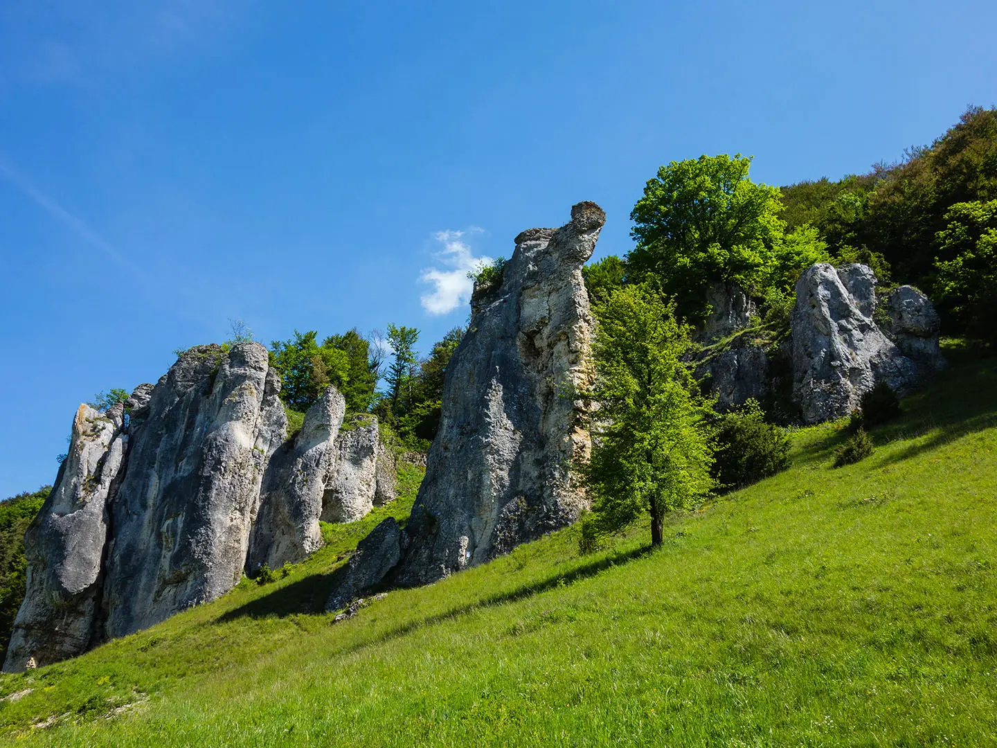
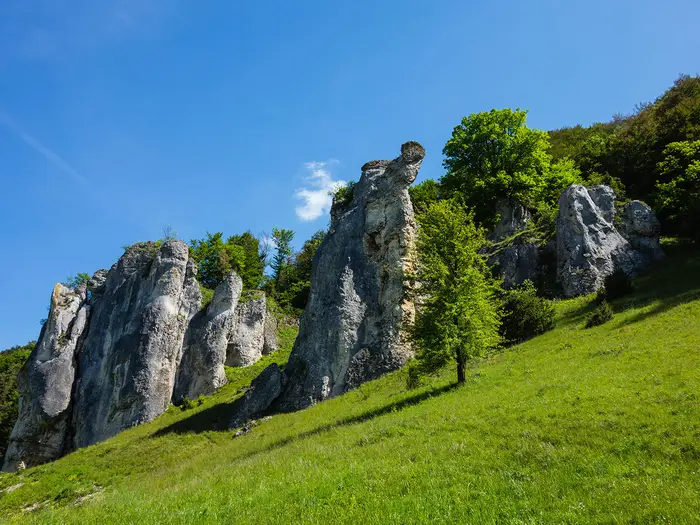
- Twelve Apostles (Zwölf Apostel): A row of jagged white Jurassic limestone pinnacles near Solnhofen. They are one of the Altmühl Valley’s signature rock formations and a strong visual marker on the route.
- Solnhofen limestone quarries: The fine-grained Jurassic limestone here yielded the famous Archaeopteryx fossil. The quarries and fossil museum make Solnhofen one of the most distinctive science-and-landscape stops on the trail.
- Eichstätt and the Willibaldsburg: Eichstätt is a handsome Baroque cathedral town overlooked by the hilltop Willibald Castle. It is one of the best cultural overnight stops on the route.
- Roman Limes at Kipfenberg: The trail crosses the UNESCO World Heritage Upper German–Raetian Limes, the former Roman frontier. Kipfenberg also has a Roman museum.
- Prunn Castle (Burg Prunn): A medieval castle perched on a sheer limestone cliff above the valley near Riedenburg. It is one of the most dramatic built landmarks on the walk.
- Weltenburg Abbey and the Danube Gorge: The finale gives a panoramic view over the Danube Gorge, with the Baroque abbey on a river bend below. Many walkers finish with a boat trip through the gorge to Kelheim.
Challenges to expect
The main challenge is distance, not altitude: 200 km and about 4,300 m of total ascent over rolling Jura terrain. Expect repeated short climbs from valley floor to viewpoints, then descents back to towns. Surfaces are mostly well-made, but include narrow trails, gravel and short asphalt sections. Navigation is helped by dedicated waymarking. Compared with longer German routes such as the Goldsteig or Eifelsteig, logistics are straightforward thanks to frequent valley accommodation.
HikeList Score
Altmühltal Panorama Trail scored 92/100 on HikeList's trail-quality metrics.
See score breakdownHide breakdown
- Ideal length 94
- Balanced challenge 100
- Scenery & wildness 82
- Varied terrain 94
- Accommodation 100
- Food & support 88
- Path quality 80
- Season flexibility 89
Computed from length, challenge, scenery & wildness, terrain variety, accommodation, food & support, path quality and season flexibility.
 Germany
Show more data Show less
- Forest
- Meadows
- Riverside
- Limestone Crags
- Juniper Heaths
- Dirt
- Gravel
- Paved
- Inns
- Guesthouses
- Hotels
- B&Bs
- Family Friendly
- Pet Friendly
- Restrooms
- Water Sources
- Campsites
- Picnic Areas
Download Our Full Guide to Altmühltal Panorama Trail FREE!
Get our comprehensive guide to this hike for free. Save it for later reading or print out at home.
In these collections
Photos from hikers
Taken on the trail by people who've reviewed Altmühltal Panorama Trail.
Altmühltal Panorama Trail: The Complete Guide
 i
Image by oxie99
i
Image by oxie99 The Altmühltal-Panoramaweg is a 200 km village-to-village walk through Bavaria’s Altmühltal Nature Park, following the River Altmühl downstream from Gunzenhausen to Kelheim. It suits walkers who want a long-distance trail with strong scenery, regular services and cultural stops, rather than a remote mountain trek.
The route moves between valley meadows, juniper heath, beech forest and the white limestone crags of the Fränkische Alb. Its best-known viewpoints include the Zwölf Apostel near Solnhofen, with further highlights at Eichstätt, Kipfenberg, Burg Prunn, Essing and the Danube Gorge finale.
This is a moderate trail: the high point is only around 630 m, but the path repeatedly climbs from the valley floor to plateaus and viewpoints. Over the full route that adds up to about 4,213 m of ascent, mostly on natural paths, fine gravel and short asphalt sections.
Logistics are one of the trail’s strengths. The official route is split into 15 stages, though many walkers combine shorter days into roughly 10, and the valley towns give frequent options for inns, guesthouses, hotels, rail access and seasonal bus links.
This guide covers stages, itinerary choices, accommodation, food, transport, terrain and the common planning mistakes to avoid.
Stage-by-Stage Guide
The official Altmühltal-Panoramaweg is divided into 15 stages. Several are deliberately short, so independent walkers often combine them, but the official structure is useful for booking accommodation and for understanding where the harder days fall.
Stage 1: Gunzenhausen to Spielberg
Approx. 12 km; +250 m / -80 m; about 3 hours. This is the easiest opening stage and works well as a half-day if arriving by train into Gunzenhausen. The walking is gentle, with field tracks, meadow paths and some asphalt as the route leaves the old town and heads into open agricultural country.
Gunzenhausen is a practical starting point, with rail access and town services before the trail. The Färberturm gives an early panorama if time allows, and St. Marien church is another useful landmark before leaving town.
The stage is low-key rather than dramatic, but in early summer the meadows can be good for butterflies, especially in June and July. The destination is dominated by Schloss Spielberg, a 14th-century castle with a distinctive skyline above the valley on the Hahnenkamm ridge; the inner courtyard contains sculpture by Ernst Steinacker.
Food and water should be sorted in Gunzenhausen before starting. Spielberg has limited overnight options, including Gasthof Gentner and Gästehaus Sticht, but it is not a large service centre, so book ahead rather than assuming availability.
Gunzenhausen has rail access on the Treuchtlingen–Gunzenhausen line, with connections towards Nuremberg and Ansbach. Navigation is straightforward on the waymarked trail, though the mixture of farm tracks and minor lanes makes it worth keeping the official route or GPX to hand at field junctions.
Stage 2: Spielberg to Treuchtlingen
Approx. 28 km; +530 m / -720 m; about 8–9 hours. This is the longest and hardest official stage, and it feels much more serious than Stage 1. It crosses the Hahnenkamm and includes sustained time on higher ground, shaded forest paths, dry grassland and limestone ridge terrain.
The route climbs from Spielberg into the Spielberger Leite nature reserve, then crosses the Hahnenkamm around the Gelbe Bürg area, where the trail reaches some of its higher western ground. Expect a more exposed, open feel on the dry grasslands, with wildflowers and butterflies in season, followed by longer descending sections towards Treuchtlingen.
The key landmark is the Steinerne Rinne bei Wolfsbronn, a remarkable tufa limestone channel where water runs over a moss-covered limestone structure. Wolfsbronn is also a useful break point, with a Gasthaus, and many walkers split the stage around Wolfsbronn or Auernheim rather than taking on the full 28 km.
Auernheim is another useful mid-stage settlement and is known as the highest village in Central Franconia. St.-Georg church is notable for its wooden gallery paintings, and local accommodation includes Pension Simon and Gasthaus Weberndorfer. After Auernheim the route descends past the Jewish cemetery and the ruined St. Ulrichs-Kapelle near Uhlberg before dropping into Treuchtlingen.
Carry enough water from Spielberg for the Hahnenkamm traverse, as there are no reliable open-plateau water sources. Food opportunities are mainly at Wolfsbronn, Auernheim and Treuchtlingen.
Treuchtlingen is a major logistical stop with a good range of hotels and town services, plus the Bayerische Obermain-Thermal-Bad for recovery after the hardest early stage. It is a railway junction on the Munich–Nuremberg line via Ansbach, making this a very easy place to start, finish or shorten a trip. Many guided itineraries begin here, skipping the Gunzenhausen–Spielberg–Treuchtlingen approach.
Stage 3: Treuchtlingen to Pappenheim
Approx. 9 km; +170 m / -180 m; about 2.5 hours. This short stage follows the Altmühl valley and is much easier than the previous day. It is a pleasant recovery stage if walking the official itinerary, or a natural candidate to combine with Stage 4.
The route begins through the river meadows of the Altmühlaue, then rises onto the valley side for broader views over the meandering river. The Teufelspulpit viewpoint is the main panoramic stop before the trail descends towards Pappenheim.
Pappenheim is one of the more attractive riverside towns on the western half of the trail. Burg Pappenheim, the castle of the former imperial marshals, dominates the approach and is the main landmark on arrival.
Food, restaurants and supermarket supplies are available in Pappenheim, and the town has a good choice of accommodation, including hotel-style options such as Hotel Sonne. Pappenheim also has a rail station on the branch line from Treuchtlingen, so it is a practical exit or overnight point for walkers keeping shorter days.
Navigation is generally simple, but the route alternates between valley-floor walking and higher side paths, so avoid assuming the trail stays beside the river all the way. In wet weather, meadow paths on the valley floor can be softer underfoot, while the higher paths are usually firmer.
Stage 4: Pappenheim to Solnhofen
Approx. 7 km; +150 m / -110 m; about 2 hours. This is a short but worthwhile stage, climbing steeply out of Pappenheim onto the Jura plateau before following sunny high paths and juniper heath above the valley.
The terrain is typical of the Altmühltal-Panoramaweg: limestone country, dry grassland, grazing sheep and open views from the valley rim. Underfoot, expect a mix of natural path, gravel and short steeper sections rather than difficult mountain terrain.
Solnhofen is famous for its fine Jurassic limestone, the Solnhofener Plattenkalk, and for the fossil discoveries associated with it, including Archaeopteryx. The Bürgermeister-Müller-Museum is the key stop in town, and quarries are visible in the surrounding landscape. Amateur fossil hunting is possible at designated sites, but access rules should be checked locally before entering any quarry area.
Services in Solnhofen are more limited than in Pappenheim or Eichstätt, with some Gasthof options rather than a large accommodation base. Many walkers continue to Mörnsheim on the same day, making Pappenheim to Mörnsheim a practical stage of about 14 km.
This stage is easy to underestimate because of its short distance. The initial climb from Pappenheim is the main effort, and in hot weather the exposed heathland can feel warm, so start with water from Pappenheim.
Stage 5: Solnhofen to Mörnsheim
Approx. 7 km; +170 m / -210 m; about 2 hours. Although short, this is one of the most scenic stages on the entire route. It passes directly above the Zwölf Apostel / Twelve Apostles, the row of jagged white Jurassic limestone pinnacles that form the signature view of the Altmühltal-Panoramaweg.
The path runs through classic Jura dry grassland and juniper heath, with wide views down into the valley. The limestone pinnacles are hard dolomitic sponge limestone that resisted erosion while softer rock wore away, creating the broken white towers seen from the trail.
Take care around viewpoints near the Twelve Apostles, especially where edges are unrailed. The terrain is not technically difficult in normal conditions, but narrow natural paths and rocky ground require more attention than the distance suggests.
Mörnsheim is a small, quiet overnight stop with basic services and Gasthof-style accommodation. Food and resupply options are limited, so do not rely on a large shop selection at the end of the day.
Stages 4 and 5 are commonly combined from Pappenheim to Mörnsheim. If staying in Solnhofen, book ahead because accommodation capacity is more limited than in the larger valley towns.
Stage 6: Mörnsheim to Dollnstein
Approx. 11 km; +270 m / -290 m; about 3 hours. This stage continues through limestone scenery, alternating between higher plateau sections, valley-side paths and some forest. It is moderate rather than difficult, but the cumulative climbing and descending is more noticeable than the official distance suggests.
The route passes through Altendorf and smaller hamlets before reaching Dollnstein. Views into the Urdonau landscape are a highlight: this is the ancient Danube valley area, where the prehistoric river once flowed before the breakthrough at Kelheim changed the drainage pattern.
Food and water between Mörnsheim and Dollnstein are limited, particularly around smaller settlements such as Altendorf. Start with enough water and snacks rather than expecting regular facilities.
Dollnstein is a useful overnight stop before the longer and more varied walk to Eichstätt. It has inn or Gasthof accommodation and a quiet valley setting, but it is still a small village, so advance booking is sensible in the main walking season.
Navigation is generally uncomplicated on the waymarked route, but pay attention where the trail leaves the obvious valley line for higher ground. Forest sections can make views and orientation less obvious than on the open heath stages.
Stage 7: Dollnstein to Eichstätt
Approx. 15 km; +350 m / -340 m; about 4 hours. This is one of the best stages of the route, with a strong mix of river valley, limestone cliffs, fossil landscape and the approach to Eichstätt. It is a moderate day, but there are repeated climbs and descents rather than a flat riverside walk.
Soon after Dollnstein the trail passes the Burgsteinfelsen, a dramatic limestone cliff and recognised geotope. It is also a climbing area, so stay on the walking route and avoid wandering below or above active climbing lines.
The path then alternates between valley-floor walking beside the Altmühl and steeper switchbacks up the valley side. Around Obereichstätt the route leaves the valley and passes the Museum Bergér area and an amateur fossil quarry, before joining the Urvogelweg, named for Archaeopteryx.
The approach to Eichstätt is memorable, with regular views towards the Willibaldsburg above the town. The final ascent on the Neuer Weg rewards the effort with a panorama over the Baroque old town before descending into the centre.
Eichstätt is the strongest overnight base on the trail, with a wide choice of accommodation, restaurants, bakeries and supermarkets. The cathedral, old town, Willibaldsburg and Jura-Museum make it a logical place for a rest day.
For transport, Eichstätt Bahnhof lies a few kilometres outside the centre (at Wasserzell), with the smaller Eichstätt Stadt station, near the old town, connected to it by a short shuttle line. Navigation into and out of town has more urban junctions than the rural stages, so follow the waymarks carefully rather than simply heading for the castle by sight.
Stage 8: Eichstätt to Walting
Approx. 12 km; +260 m / -230 m; about 3.5 hours. This stage climbs out of Eichstätt past the high ground near the Willibaldsburg and heads onto plateau paths south of the town. It is a moderate day with a mix of grassland, forest and open views back towards Eichstätt.
The route passes Buchenhüll and the Mammuthöhle, a small cave associated with prehistoric finds. The walking is typical Franconian Jura terrain: firm paths, sections of forest, dry grassland and periodic viewpoints rather than continuous riverside walking.
Carry water from Eichstätt, as supplies are limited on the plateau before Walting. Food options are also sparse once out of town.
Walting is a small village with limited accommodation, generally Gasthof-style. It is a useful overnight if following the official stages, but walkers wanting more services may need to plan carefully or continue by arrangement.
Navigation is straightforward on the marked route, though forest and plateau junctions require attention. The main route warning concerns the next stage: the Arnsberger Leite section between Arnsberg sports field and Böhming has a signed diversion in place until around October 2026 for rock-face stabilisation works. This should be checked before travelling.
Stage 9: Walting to Kipfenberg
Approx. 18 km; +440 m / -460 m; about 5 hours. This is one of the harder central stages, with significant ascent and descent and some of the most dramatic valley-side limestone terrain on the route. It is a full walking day rather than a gentle village-to-village stroll.
Current route note: the Arnsberger Leite section between Arnsberg sports field and Böhming, near the old Altmühl bridge, is closed for rock-face stabilisation works until around October 2026. A signed diversion via the Schmetterlingsweg is in place, running for roughly 5 km through forest and juniper heath. Check the Naturpark Altmühltal information before travelling, as this affects the line walked on the day.
When open, the normal route through the Arnsberger Leite is one of the trail’s most spectacular sections, traversing a steep limestone slope above the valley. The stage also includes the Gungolding juniper heath, an important nature protection area that is especially attractive in early summer.
The route crosses the line of the UNESCO World Heritage Upper German-Raetian Limes and passes a Roman signal tower. Around Böhming, the Roman fort site adds another historical landmark before the trail continues towards Kipfenberg.
Food and water options are limited between villages, so leave Walting prepared. Kipfenberg has better services, including accommodation, a bakery, supermarkets and restaurants.
Kipfenberg is a good overnight stop and a major Roman-history point on the trail, with the Römer und Bajuwaren Museum / Roman Museum Kipfenberg and Burg Kipfenberg above the village. Local bus connections link Kipfenberg with Eichstätt, which can be useful for section walkers. Navigation on the diversion should follow the temporary signs on the ground, not an old GPX track through the closed Arnsberger Leite.
Stage 10: Kipfenberg to Kinding
Approx. 9 km; +160 m / -200 m; about 2.5 hours. This short stage gives an easier day after the longer Walting–Kipfenberg section. It uses panoramic paths and offers views over the Anlauter valley, with the Osterberg area providing the main high-ground outlook.
The terrain is moderate, with a familiar mix of firm natural paths, gravel and short climbs rather than any sustained ascent. Because the distance is short, many walkers combine this stage with Stage 11 to make a longer Kipfenberg–Beilngries day.
Kinding’s main landmark is its Wehrkirche, a fortified medieval church enclosed by defensive walls on the hill above the village. Services in Kinding are limited compared with Kipfenberg or Beilngries, so check accommodation and evening food before committing to an overnight here.
Kinding has public-transport access, including rail access on the Nuremberg–Munich high-speed line at Kinding. Local bus options may also be useful for linking valley settlements, but current timetables should be checked before travelling.
Navigation is uncomplicated in normal conditions. The main planning issue is whether to stop in Kinding or continue: if combining with Stage 11, the total day becomes substantially longer and should be treated as a full walking day.
Stage 11: Kinding to Beilngries
Approx. 19 km; +410 m / -410 m; about 5.5 hours. This is a harder stage, with more climbing than the map distance might imply. It moves through a varied landscape of valley paths, plateau sections and limestone formations before descending steeply into Beilngries.
The route passes the Arzberg ridge area and gives increasing views of the Main-Danube Canal landscape as the eastern half of the trail develops. Expect a mixture of open panoramic paths, rocky features and woodland rather than continuous easy valley walking.
Carry water and food from Kinding, as intermediate services are not as dependable as in the larger towns. The final descent into Beilngries can be tiring late in the day, particularly in wet conditions or after combining this stage with Stage 10.
Beilngries is one of the best service stops in this section, with a good range of accommodation, supermarkets and restaurants. The town’s medieval walls and towers make it a rewarding overnight rather than just a logistical halt.
Beilngries is served by bus, and the seasonal Altmühltal-Bus operates in the valley. Current bus timetables should be checked before building a section walk around them.
Stage 12: Beilngries to Dietfurt an der Altmühl
Approx. 11 km; +260 m / -220 m; about 3 hours. This is a relatively gentle stage after the harder Kinding–Beilngries day. It climbs to the Arzberg ridge, a broad plateau between the Altmühl and the Main-Danube Canal, before descending into Dietfurt.
The Kottingwörth quarry is the main geological stop, showing rock layers of the Franconian Jura plateau. The walking is mostly straightforward, with plateau paths, views and a descent rather than any technical ground.
Beilngries is the best place to buy food before starting. Dietfurt has good services at the end of the stage, including hotel and Gasthaus accommodation, restaurants and town facilities.
Dietfurt an der Altmühl is known as the Sieben-Täler-Stadt, the “Town of Seven Valleys”. It is also associated with the local Chinesenfasching tradition, though this is a seasonal festival rather than a planning factor for most walkers.
Transport access is available at Dietfurt on the Regensburg–Ingolstadt line according to the route transport notes. As always in this region, current public-transport timetables should be checked before travelling.
Stage 13: Dietfurt an der Altmühl to Riedenburg
Approx. 23 km; +510 m / -560 m; about 6.5 hours. This is the longest and most demanding of the final stages. It is a serious full-day walk, with several climbs, canal-side sections and viewpoints, and it is a good candidate for splitting if the accommodation plan allows.
The route runs partly along the Main-Danube Canal landscape, including the older historic Ludwig-Donau-Main-Kanal section. Boardwalks through wetland areas add variety, but also mean footwear with decent grip is useful in damp conditions.
The major viewpoint is the Teufelsfelsen / Devil’s Rock, a dramatic limestone outcrop above a canal loop near Gundlfing. The stage also gives views of Schloss Eggersberg, a four-cornered castle above the valley that now functions as a hotel and houses the Hofmark Museum.
Some walkers split this stage at Mühlbach or Gundlfing. Accommodation and transport at any intermediate stopping point should be checked before travelling, as this is not as simple as stopping in one of the larger towns.
Start from Dietfurt with enough food and water for a long day. Riedenburg has good accommodation, restaurants and bus connections at the end, making it a practical place to recover before the more rugged Stage 14.
Navigation is not difficult on the waymarked trail, but the mix of canal paths, side valleys and climbs to viewpoints makes it important to follow the official line rather than staying beside the water by habit.
Stage 14: Riedenburg to Essing
Approx. 10 km; +320 m / -300 m; about 3 hours. Despite the short distance, this is one of the most technically demanding stages of the Altmühltal-Panoramaweg. It includes steep sections, rocky Jura terrain, gorge-like forest and paths where sure-footedness matters.
Current route note: the Einthal area is not passable because of construction works, and a temporary signed diversion is in place. Check the Naturpark Altmühltal route information before travelling and follow the signs on the ground rather than an older GPX line.
The stage is highly scenic, with enclosed forest, boulders, gnarled trees and jagged limestone formations. The main landmark is Burg Prunn, one of Bavaria’s most dramatically sited medieval castles, perched on a sheer limestone cliff above the Altmühl near Riedenburg and Essing.
Guide ratings for this stage commonly treat it as hard, requiring sturdy footwear and confident footing. It is not alpine in altitude, but it is rougher and steeper than many other sections of the route, especially in wet conditions.
Essing is a tiny village squeezed between the Ludwig-Donau-Main-Kanal and towering limestone cliffs. Its standout landmark is the Tatzelwurm, a roughly 193 m wooden footbridge over the canal (one of the longest wooden bridges in Europe), with views towards the Burg Randeck ruins above the village.
Accommodation in Essing is limited, with small Gasthaus-style options. Many walkers either book well ahead, stay in Riedenburg and arrange transport, or continue towards Kelheim depending on the itinerary.
Stage 15: Essing to Kelheim
Approx. 14 km; +260 m / -280 m; about 4 hours. The final stage is a strong finish, moving from Essing’s cliffs and canal landscape towards the Danube Gorge and Kelheim. It combines forest paths, rock faces, archaeological features and the classic Weltenburg finish.
From Essing, the route uses the Tatzelwurm bridge area and then continues on forest trail roughly parallel to the Main-Danube Canal. The Klausenhöhle caves mark Ice Age cave occupation sites along the way, and the Schellnecker Wände provide dramatic rock faces above the canal.
Further on, the Keltenwall gives a notable archaeological feature from a Celtic oppidum. The final high point above the Donaudurchbruch / Danube Gorge is one of the great views of the route, with the Danube cutting through white Jura cliffs.
Most walkers treat Kloster Weltenburg as the emotional finale before Kelheim. The Benedictine abbey sits on a bend of the Danube and includes the Baroque Asamkirche and the monastery brewery, with a beer garden overlooking the river.
The traditional finish is to take the excursion boat from Weltenburg through the Danube Gorge to Kelheim. Boats normally run for a long season from around mid-spring into autumn, but exact operating dates and daily timetables change year to year and should be checked before arrival. If the boat is not running, an alternative is to continue on foot along the Danube bank; local crossing options such as the Zille cable ferry should also be checked before relying on them.
Kelheim is the official end point, with accommodation, bus connections and onward transport links. The Befreiungshalle on the Michelsberg above the Danube is the landmark finish-line above town; it can be reached on foot by a steep climb or by the Ludwigsbahn mini-train when operating.
Food and drink are available at Weltenburg and in Kelheim, but do not leave Essing without water for the walking section. Navigation is generally clear, though the boat finish can complicate timing: plan the walking day around the current sailing timetable rather than arriving at Weltenburg assuming a late service will be available.
Recommended Itinerary
The Altmühltal-Panoramaweg is unusually flexible because the official stages are short and uneven. The full route is listed as about 200 km, but the rounded official stage distances add up to about 205 km, so treat all daily totals as approximate and check official mapping before booking accommodation.
For most independent walkers, a 10-day itinerary is the best balance: it keeps the trip compact, uses the obvious valley overnight stops, and combines several very short official stages. It does include a few long days of around 28–30 km, so slower walkers, families and anyone wanting more time in Eichstätt, Solnhofen or the lower Altmühl valley should use the 15-day version.
Standard itinerary — 10 walking days
Suits fit walkers who are comfortable with repeated 20 km-plus days on moderate valley and plateau terrain, and who want to complete the route in a compact trip without rushing every day.
| Day | From | To | Approx. distance | Why this stage makes sense | Services/accommodation notes |
|---|---|---|---|---|---|
| 1 | Gunzenhausen | Spielberg | 12 km | A short first day gives time for arrival in Gunzenhausen and an easy start from the Altmühlsee / upper Altmühl. | Gunzenhausen has strong public-transport access. Spielberg is a smaller overnight stop, so accommodation should be booked ahead. |
| 2 | Spielberg | Treuchtlingen | 28 km | This is a long but logical official stage, moving you into one of the better-connected valley towns. | Treuchtlingen is on or near the rail line and is a practical place to end a longer day. |
| 3 | Treuchtlingen | Solnhofen | 16 km | Combines the two short official stages via Pappenheim, avoiding two very short walking days. | Treuchtlingen, Pappenheim and Solnhofen all have useful rail access, giving good options if the day needs shortening. |
| 4 | Solnhofen | Dollnstein | 18 km | Combines Solnhofen–Mörnsheim and Mörnsheim–Dollnstein into a sensible mid-length day through one of the classic limestone sections. | Solnhofen and Dollnstein are practical overnight points with rail access. Mörnsheim is the natural midway split if needed. |
| 5 | Dollnstein | Eichstätt | 15 km | A manageable day into Eichstätt, one of the best places on the route for an overnight stop and extra time. | Eichstätt has strong accommodation appeal and access via Eichstätt Bahnhof. Consider booking early in busy periods. |
| 6 | Eichstätt | Kipfenberg | 30 km | A long but efficient day, combining the official Eichstätt–Walting and Walting–Kipfenberg stages. Split at Walting if 30 km is too much. | Check the official route status before travelling, especially around the Arnsberger Leite / Eichstätt area where a signed diversion is expected into autumn 2026. Kipfenberg is an important stop on the Roman Limes section. |
| 7 | Kipfenberg | Beilngries | 28 km | Combines the short Kipfenberg–Kinding stage with the longer Kinding–Beilngries stage, keeping the overall schedule to 10 days. | Kinding offers useful public-transport access if the day needs breaking. Beilngries is a logical larger overnight stop in this part of the valley. |
| 8 | Beilngries | Dietfurt an der Altmühl | 11 km | A short recovery day after two long stages, with time to start later or use the afternoon for rest. | Both are recognised valley stops; book ahead if relying on a specific accommodation type. |
| 9 | Dietfurt an der Altmühl | Riedenburg | 23 km | A solid full walking day that follows the natural sequence of the lower Altmühl valley. | Riedenburg is the key overnight stop before the final Essing / Kelheim section. |
| 10 | Riedenburg | Kelheim | 24 km | Combines the final two official stages via Essing, giving a strong finish through the lower valley and towards Kelheim. | Essing can be used to split the day. Many walkers build in the Weltenburg Abbey and Danube Gorge boat finish near Kelheim; current boat timetables and any closures should be checked before travelling. |
Slower itinerary — 15 official stages
This is the best option for families, first-time long-distance walkers, anyone carrying full luggage, or walkers who want shorter days for sightseeing. The trade-off is more accommodation bookings and several very short walking days.
| Day | From | To | Approx. distance | Why this stage makes sense | Services/accommodation notes |
|---|---|---|---|---|---|
| 1 | Gunzenhausen | Spielberg | 12 km | Easy opening stage from the western start of the route. | Gunzenhausen is a strong access point; book Spielberg accommodation ahead. |
| 2 | Spielberg | Treuchtlingen | 28 km | The longest official day and the main demanding stage of the slower schedule. | Treuchtlingen is well placed for public transport and overnight logistics. |
| 3 | Treuchtlingen | Pappenheim | 9 km | Short stage after the long Spielberg–Treuchtlingen day. | Rail access in both towns makes this an easy day to adjust. |
| 4 | Pappenheim | Solnhofen | 7 km | Very short official stage, useful if allowing time around Solnhofen and its fossil heritage. | Solnhofen has rail access and is a practical overnight point. |
| 5 | Solnhofen | Mörnsheim | 7 km | Keeps the pace very gentle through the limestone landscape near the Zwölf Apostel / Twelve Apostles area. | Mörnsheim is a smaller stop; book ahead rather than assuming availability. |
| 6 | Mörnsheim | Dollnstein | 11 km | A short-to-moderate day continuing through the central valley section. | Dollnstein has useful rail access. |
| 7 | Dollnstein | Eichstätt | 15 km | A comfortable day into one of the main cultural stops on the route. | Eichstätt is one of the best overnight bases; Eichstätt Bahnhof gives rail access. |
| 8 | Eichstätt | Walting | 12 km | Short day east of Eichstätt, leaving time for the town before departure. | Check the official route status before travelling because of the Arnsberger Leite diversion in the Eichstätt area. Walting is a smaller overnight stop. |
| 9 | Walting | Kipfenberg | 18 km | Moderate day to the Roman Limes section at Kipfenberg. | Accommodation should be arranged in advance, especially outside the larger towns. |
| 10 | Kipfenberg | Kinding | 9 km | Short official stage, useful for rest or for using Kinding’s transport access. | Kinding is on or near the rail line and is a practical point for joining or leaving the route. |
| 11 | Kinding | Beilngries | 19 km | A more typical full walking day after the short Kipfenberg–Kinding stage. | Beilngries is a logical overnight stop before the Dietfurt section. |
| 12 | Beilngries | Dietfurt an der Altmühl | 11 km | Short day that keeps the official rhythm and reduces fatigue before the longer Dietfurt–Riedenburg stage. | Accommodation is available in the valley towns, but specific availability should be checked before booking the wider trip. |
| 13 | Dietfurt an der Altmühl | Riedenburg | 23 km | One of the longer official stages, but still well within a steady day for most prepared walkers. | Riedenburg is the main stop before Essing and Kelheim. |
| 14 | Riedenburg | Essing | 10 km | Short scenic stage with time for the lower-valley highlights around Essing. | Essing is a smaller stop; book ahead if overnighting here. |
| 15 | Essing | Kelheim | 14 km | Final official stage to the eastern end of the Altmühltal-Panoramaweg. | Kelheim is the finish point and a key public-transport exit. If using the Danube Gorge boat from the Weltenburg area, check the current timetable before relying on it. |
Faster variant — 9 walking days
This version is for strong walkers with efficient daily routines, light packs or luggage transfer, and accommodation already fixed. It saves one day by making the Eichstätt–Walting and Kinding–Dietfurt links part of longer stages; it is not the best choice for a relaxed first long-distance walk.
| Day | From | To | Approx. distance | Why this stage makes sense | Services/accommodation notes |
|---|---|---|---|---|---|
| 1 | Gunzenhausen | Spielberg | 12 km | Keeps the first day short for arrival logistics. | Book Spielberg ahead; Gunzenhausen is the stronger transport access point. |
| 2 | Spielberg | Treuchtlingen | 28 km | Uses the long official second stage without adding more distance. | Treuchtlingen is a practical rail-connected overnight stop. |
| 3 | Treuchtlingen | Solnhofen | 16 km | Combines two short official stages via Pappenheim. | Rail access at Treuchtlingen, Pappenheim and Solnhofen gives flexibility. |
| 4 | Solnhofen | Dollnstein | 18 km | Combines two short-to-moderate stages via Mörnsheim. | Dollnstein is a useful overnight point with rail access. |
| 5 | Dollnstein | Walting | 27 km | Pushes beyond Eichstätt to reduce the total trip length while still keeping the day below the longest standard-stage combinations. | Eichstätt is the obvious bail-out or upgrade stop if accommodation in Walting is limited. Check the Arnsberger Leite / Eichstätt-area diversion before travelling. |
| 6 | Walting | Kinding | 27 km | Links the Walting–Kipfenberg and Kipfenberg–Kinding official stages. | Kinding gives useful public-transport access at the end of the day. |
| 7 | Kinding | Dietfurt an der Altmühl | 30 km | Combines Kinding–Beilngries and Beilngries–Dietfurt into the longest day of this faster schedule. | Beilngries is the sensible place to split the day if conditions, heat or fatigue make 30 km unrealistic. |
| 8 | Dietfurt an der Altmühl | Riedenburg | 23 km | Keeps the lower-valley section moving without creating another very long day. | Riedenburg is the key overnight stop before the final stage combination. |
| 9 | Riedenburg | Kelheim | 24 km | Combines the final two official stages via Essing. | If planning the popular Weltenburg / Danube Gorge boat finish, check current operation times before travelling and avoid relying on the last service of the day. |
Planning the Route
How many days to allow
The official Altmühltal-Panoramaweg is divided into 15 stages, but those stages are deliberately short and uneven. Most walkers should plan around 10 walking days, which gives a sensible balance between progress, accommodation availability and time in the main valley towns.
A slower 12–14 day schedule suits walkers who want easier days, time in Eichstätt, Beilngries or Riedenburg, or more flexibility around weather and transport. Fit walkers can compress the route into 8–9 days, but that turns a moderate cultural trail into a more sustained long-distance hike with several long days back-to-back.
| Pace | Best for | Planning note |
|---|---|---|
| 15 days | Very relaxed itineraries, families, sightseeing-heavy trips | Follows the official stage pattern, but includes several very short walking days. |
| 12–14 days | Most walkers wanting comfort and time in towns | Allows some short stages to be combined without forcing too many 25 km+ days. |
| About 10 days | Standard independent hiking pace | Common approach; combine the shortest official stages and keep the harder ones manageable. |
| 8–9 days | Fast, fit walkers | Requires long days and careful accommodation planning, especially east of Eichstätt. |
Combining stages sensibly
The main planning issue is that the official stages are not evenly balanced. Stages 3, 4 and 5 between Treuchtlingen, Pappenheim, Solnhofen and Mörnsheim are only 7–9 km each, so they are commonly combined.
Stage 2 from Spielberg to Treuchtlingen is the opposite problem: at about 28.5 km, it is the longest and hardest official day. Many walkers split it, adjust the start of the trip, or begin at Treuchtlingen if they want to avoid the less flexible early section.
Useful combinations include:
| Section | Practical use |
|---|---|
| Treuchtlingen–Pappenheim–Solnhofen | Combines two short official stages into a moderate day of roughly 15 km. |
| Pappenheim–Solnhofen–Mörnsheim | Another practical short-stage combination of roughly 14 km. |
| Walting–Kipfenberg–Kinding | Around 27 km if combined; better kept separate unless you are fit and have a confirmed bed. |
| Beilngries–Dietfurt an der Altmühl–Riedenburg | Possible for strong walkers, but note that Dietfurt–Riedenburg alone is about 23 km. |
Daily stages are largely dictated by accommodation clusters rather than by terrain difficulty. The most useful overnight bases are Gunzenhausen, Treuchtlingen, Pappenheim, Eichstätt, Kipfenberg or Kinding, Beilngries, Riedenburg and Kelheim, with smaller stops such as Mörnsheim, Dollnstein and Walting needing more careful booking.
What to book first
Accommodation is the limiting factor on this trail, not navigation or mountain difficulty. Book beds before committing to a fixed day-by-day schedule, especially in July and August, over Bavarian school-holiday weekends, or if stopping in smaller villages.
Eichstätt has the broadest choice and is one of the busiest overnight stops; in high season it is sensible to book 2–3 months ahead. Mörnsheim, Dollnstein, Walting and Kinding have more limited accommodation, so do not build an itinerary around those stops until availability is clear.
A practical order for planning is:
- Accommodation — fix the overnight stops first.
- Finish logistics from Kelheim — Kelheim has no mainline station, so onward travel needs planning.
- Travel to Gunzenhausen — rail access is good from major Bavarian hubs.
- Walking pace — decide whether to follow 15 stages, merge to around 10 days, or shorten the route.
- Navigation files and guidebook — download GPX files before travelling and carry an offline option.
Self-guided packages with luggage transfer are common on the Altmühltal-Panoramaweg. Operators such as Kleins Wanderreisen, Eurohike and Alpenlandtouristik offer packaged itineraries; prices, inclusions and bag-transfer arrangements should be checked before booking.
Wild camping is not permitted in the Naturpark Altmühltal. Plan to use Gasthöfe, guesthouses, hotels, B&Bs, private rooms or established campsites where available.
Transport and section hiking
The western half is the easiest part to section-hike. Gunzenhausen, Treuchtlingen, Pappenheim, Solnhofen, Dollnstein and Eichstätt have useful rail access along or near the valley, which makes it easier to shorten days, skip poor weather or walk the route over several weekends.
East of Eichstätt, flexibility reduces because railway access is less frequent. Kinding is an important rail-linked point, but for places such as Beilngries, Dietfurt an der Altmühl, Riedenburg, Essing and Kelheim, buses and seasonal services become more important.
Kelheim itself has no mainline railway station. The nearest rail access is Saal an der Donau, about 6 km away, with trains towards Ingolstadt and Regensburg; bus travel from Kelheim towards Regensburg is also an option. This should be checked before travelling.
Seasonal Freizeitbus services can help with section hiking in the eastern half. Freizeitbus 1 links Regensburg, Riedenburg and Kelheim on weekends and public holidays from mid-April to early October, while Freizeitbus 2 links Eichstätt and Riedenburg on weekends and public holidays from May to October. Current timetables should be checked at bayern-fahrplan.de before relying on them.
The Danube Gorge boat between Weltenburg and Kelheim is a popular way to finish the route. It is seasonal, and summer sailings can be busy, so check the current timetable and booking arrangements before building it into the final day.
Shortening or extending the walk
The easiest way to shorten the Altmühltal-Panoramaweg is to start at Treuchtlingen, skipping the first two official stages from Gunzenhausen via Spielberg. This saves two days and avoids the awkward long Spielberg–Treuchtlingen stage.
Eichstätt also makes a strong partial-route end point because of its services and transport access. Riedenburg can work as a later cut-off when bus connections fit, but it needs more careful planning than the rail-served western towns.
The most natural non-walking extension is the Weltenburg–Kelheim boat through the Danube Gorge. For a rest day, Eichstätt is the obvious choice, with Beilngries and Riedenburg also useful if the itinerary allows.
Food and water
This is not a remote food-carrying route. Villages and towns appear regularly on most stages, and Eichstätt has the best range of shops and restaurants on the route.
Carry a normal day supply of water and snacks, rather than multi-day food. Springs and streams exist, but any untreated water should be filtered or treated.
Plan ahead for Sundays and public holidays, when shops may be closed. This matters most if a longer stage finishes in a smaller village with limited services.
Navigation and route changes
The trail is waymarked throughout with the Altmühltal-Panoramaweg logo and is generally straightforward to follow. Even so, carry an offline map or GPX file, because detours, forestry work and missed signs can still cost time.
Official GPX data is available from Naturpark Altmühltal. Outdooractive and Komoot are widely used for digital navigation, and the Hikeline guidebook from Esterbauer is a common paper option.
Check current route notices before setting out. The Arnsberger Leite section on the Walting–Kipfenberg leg is closed for rock-stabilisation works until approximately autumn 2026, with a signed detour via the Schmetterlingsweg between Arnsberg Sportplatz and Böhming Alte Altmühlbrücke. There is also a temporary closure on the Einthal section between Riedenburg and Essing requiring a marked alternative route; this should be checked before travelling.
Season, weather and permits
April to October is the practical walking season, with the best public-transport support in the warmer months. Spring is cooler and quieter, summer brings more accommodation pressure and possible heat in the valley, and autumn usually offers comfortable walking conditions with fewer crowds.
Winter walking is possible in principle, but it is not the best choice for a full thru-hike. Accommodation is more limited, seasonal buses do not run, and short daylight reduces flexibility.
No trail permit is required and there is no national-park entry fee for walking the Altmühltal-Panoramaweg. Budget instead for accommodation, meals, local transport, luggage transfer if used, and any boat travel at the Kelheim end.
Towns, Villages and Overnight Stops
The Altmühltal-Panoramaweg is well suited to village-to-village walking, but the official 15-stage pattern uses several very small places with limited beds and services. For a smoother independent itinerary, most walkers build nights around the larger hubs — Gunzenhausen, Treuchtlingen, Eichstätt, Beilngries, Riedenburg and Kelheim — and use smaller villages as lunch stops or short-stage alternatives.
Book ahead in the smaller places, especially if walking in summer, at weekends or during local events. Many Gasthöfe are family-run and may have limited check-in times, restaurant rest days or only a handful of rooms.
| Best stop type | Places |
|---|---|
| Strongest overnight and resupply bases | Gunzenhausen, Treuchtlingen, Eichstätt, Beilngries, Riedenburg, Kelheim |
| Useful smaller overnight stops | Pappenheim, Solnhofen, Dollnstein, Kipfenberg, Dietfurt an der Altmühl |
| Limited-facility stage stops | Spielberg, Mörnsheim, Walting, Kinding, Essing |
Luggage transfer is widely available through self-guided walking operators, and is especially useful if combining the short official stages into longer 10-day-style walking days. Shops are best in the larger towns; smaller villages may have only basic food options, a bakery or a Gasthof, so carry lunch when the next stop is small.
Gunzenhausen
Gunzenhausen is the western trailhead, at the upper River Altmühl near the Altmühlsee. It is one of the most practical places to spend the night before starting, with hotels, Gasthöfe, restaurants and a full range of town-centre shops.
The town is on the railway line linking Nürnberg, Pleinfeld, Gunzenhausen, Treuchtlingen and Donauwörth, so arrivals by public transport are straightforward. It is also the last easy place to sort forgotten kit, food and cash before moving into the smaller first-stage villages.
The route leaves the old town towards Spielberg and the Altmühlsee. If arriving early, the lake area has a barrier-free promenade and bird reserve, but treat this as an optional warm-up rather than part of the through-walk logistics.
Spielberg
Spielberg is the end of the short first official stage from Gunzenhausen, roughly 12 km into the route. It is a small village rather than a full service base, with limited guesthouse availability and little depth if the few beds are full.
This stop works best for walkers deliberately keeping to the official 15-stage schedule or wanting a gentle first day. Many hikers instead continue towards Treuchtlingen, combining the first two stages into a longer opening day.
There is no significant rail link at Spielberg, so accommodation and onward plans need to be arranged in advance. Do not rely on finding late-notice rooms or extensive evening food options here.
Treuchtlingen
Treuchtlingen is the first major overnight hub and one of the most useful resupply points in the western half of the trail. It is a spa town and railway junction, with links on the Gunzenhausen line as well as connections towards Ansbach and Donauwörth.
Accommodation depth is much better than in the preceding villages, with options including Altmühlhotel Treuchtlingen, Hotel Adler Treuchtlingen and other Gasthöfe. There are supermarkets, town-centre shops and restaurants, making this a practical place to restock food and adjust plans.
The Altmühltherme thermal spa is a useful recovery stop after a longer day, with indoor and outdoor thermal pools using Jura mineral water. Entry prices vary by duration and should be checked before travelling.
Some walking operators start itineraries in Treuchtlingen rather than Gunzenhausen. The Town Hall area is close to the station via Bahnhofstraße, which makes it easy to join the route here for a shorter version.
Pappenheim
Pappenheim is a compact historic town and a popular overnight stop, especially for walkers who want a quieter night without losing rail access. Its railway station makes it one of the easier places to leave or rejoin the route in the early section.
The official stage from Treuchtlingen to Pappenheim is only about 9 km, so many walkers continue another short stage to Solnhofen. Used as a stopping point, Pappenheim suits a relaxed schedule, a half-day arrival or a recovery night.
Burg Pappenheim dominates the skyline, and the old town is small enough to handle easily after walking. Landgasthof zum Grünen Baum is one named eating option on the route, serving Franconian specialities and game dishes.
Solnhofen
Solnhofen is a small but important cultural stop, known for its Jurassic lithographic limestone and fossils. The Bürgermeister-Müller-Museum has Archaeopteryx material and marine fossils, and the Zwölf Apostel limestone pinnacles nearby are one of the signature views of the trail.
Accommodation exists but the village is small, so booking ahead is sensible. Options named on the route include Gasthof Zum Verkauften Großvater, a family-run hotel with home-made beer, and Hotel-Gasthof zur Sonne, serving Bavarian food including Altmühltal lamb specialities.
Food and resupply are more limited than in Treuchtlingen or Eichstätt. If staying here, arrive with any essential snacks already bought.
The official Pappenheim to Solnhofen stage is only about 7 km, and Treuchtlingen to Solnhofen via Pappenheim is still a manageable combined day for many walkers. Solnhofen has valley rail access, but current train times should be checked before relying on it for a stage break.
Mörnsheim
Mörnsheim is a small village about 7 km beyond Solnhofen. It is a genuine official overnight stop, but facilities and accommodation are limited.
This is best used by walkers following the 15-stage schedule closely, or by anyone wanting a deliberately short day after time in Solnhofen. Many walkers combine Solnhofen, Mörnsheim and Dollnstein into a longer continuous section to avoid an overnight in a very small place.
Plan food carefully if stopping here. Evening meals may depend on the accommodation or a local Gasthof, and this should be checked before travelling.
Dollnstein
Dollnstein is a small but useful valley stop at the mouth of the Anlauter valley. It has some guesthouse accommodation and works well as a quieter alternative between the fossil country around Solnhofen and the larger town of Eichstätt.
The official stage from Mörnsheim is about 11 km, while the next stage to Eichstätt is about 15 km. Dollnstein therefore suits walkers who want to keep the middle section comfortable without committing to a very long day.
Facilities are modest compared with Eichstätt. It is better treated as a bed-and-meal stop than as a major resupply base, although valley rail access makes it useful for joining, leaving or shortening the route.
Eichstätt
Eichstätt is the strongest overnight stop in the middle of the Altmühltal-Panoramaweg. It is a university town and Baroque cathedral city, with a good spread of hotels, Gasthöfe, cafés, restaurants, supermarkets and town-centre shops.
This is the best place on the route for a rest afternoon, laundry arrangements, replacement food and a more flexible choice of dinner. Accommodation options include IBB Hotel Altmühltal-Eichstätt opposite Eichstätt Stadt station, Braugasthof Trompete in the old town, Gasthof Krone and Hirschenwirt in the Wasserzell district.
Eichstätt has two rail stops that matter to walkers. Eichstätt Bahnhof is on the main valley line at Wasserzell, while Eichstätt Stadt is on the shuttle branch into the old town; check which one is nearest to your accommodation before booking tickets.
The approach from Dollnstein is a worthwhile but more physical day than the distance alone suggests, with repeated ascent and descent in this section. Arrival in Eichstätt gives easy access to the Dom, the historic streets and the Willibaldsburg above the valley.
Walting
Walting is a small official stage stop about 12 km beyond Eichstätt. It is mainly useful for walkers keeping the daily distances short, as accommodation and services are limited.
Many hikers combine this stage with the onward section towards Kipfenberg, using Walting as a lunch stop rather than an overnight. If staying, book ahead and confirm dinner options before travelling.
There has been a temporary diversion on the Arnsberger Leite section between Walting and Kipfenberg for rock-safety works, with an alternative route signed via the Schmetterlingsweg. This is expected to run into autumn 2026 and should be checked before travelling.
Kipfenberg
Kipfenberg is one of the better smaller overnight stops, and a natural base before or after the Walting section. The trail crosses the UNESCO World Heritage Upper German-Raetian Limes here, giving the town more interest than its size suggests.
Accommodation options include Gasthof zum Limes in the centre, Gasthof Zum Blauen Hecht and Hotel Römer-Castell. There are some restaurants and local services, though it is still a compact market town rather than a large resupply hub.
The Römer und Bajuwaren Museum Burg Kipfenberg is the main local visit, with a Limes information point and Roman watchtower tours. The Buchenhüller mammoth cave is also nearby.
Kipfenberg is not as convenient by rail as the main valley towns, so use regional buses or the seasonal Altmühltal hop-on/hop-off bus where available. Current timetables should be checked before travelling.
Kinding
Kinding is a small valley town about 9 km beyond Kipfenberg. It can be used as a short-stage overnight, but facilities and resupply are limited.
Hotel zum Bräu in the nearby Enkering district is one accommodation and restaurant option used as a walking and cycling base. Check the exact location against the walking route before booking, especially if avoiding extra distance at the end of the day.
Kinding has rail access in the Altmühltal, which makes it useful for joining or leaving the trail. For through-walkers, it is often more practical as a staging point before the longer walk to Beilngries than as a place for extensive resupply.
Beilngries
Beilngries is the best overnight base in the eastern middle section and a good reward after the roughly 19 km stage from Kinding. The compact old town has intact town-wall towers, Baroque architecture, cafés, restaurants, shops and a small supermarket.
Accommodation depth is better here than in the smaller preceding villages. Named options include Romantikhotel Der Millipp and Hotel Zur Krone in the centre of Beilngries; current prices should be confirmed before booking.
The town sits on the Main-Danube Canal, which adds an easy waterside feel to the evening and gives some variety after the hill-and-valley walking. Some walkers also use boat sections in this broader canal area, but any service should be checked against current timetables.
Beilngries is a sensible place to restock before the final third of the trail. It is also a good point to adjust the itinerary if combining the next short stage to Dietfurt an der Altmühl with the longer onward stage to Riedenburg.
Dietfurt an der Altmühl
Dietfurt an der Altmühl is a pleasant valley town at a bend in the Altmühl, about 11 km beyond Beilngries. It works well as a comfortable short-stage stop or as a lunch and resupply break before a longer push east.
There are family-run guesthouses, cafés and restaurants, with additional accommodation in nearby districts such as Töging. One local guesthouse in the Töging district offers bicycle and boat rental, which can be useful for travellers adding non-walking time in the valley.
The town is known locally for its Chinesenfasching carnival tradition, a distinctive local detail rather than a core hiking logistic. For walkers, the practical value is its position between Beilngries and the longer day to Riedenburg.
Riedenburg
Riedenburg is a key overnight stop in the final third of the route and the best practical base before the Essing and Kelheim finish. The stage from Dietfurt an der Altmühl is about 23 km, making it one of the longer official days, so arriving with accommodation already booked is wise.
The town has reasonable shops and services for resupply, plus restaurants and a stronger choice of beds than the surrounding villages. Hotel-Gasthof zur Post is a central old-town option, while Hotel-Gasthof zur Krone Prunn sits near Burg Prunn and the local climbing rocks, directly by hiking trails.
Riedenburg is overlooked by Tachenstein, Rosenburg and Rabenstein castles. Burg Rosenburg has a working falconry centre with seasonal birds-of-prey displays; current opening times and entry prices should be checked before planning a visit.
Burg Prunn, near Riedenburg and Essing, is one of the major Altmühltal highlights, set on a limestone cliff above the valley. If adding time here, allow for the castle visit rather than trying to fit too much into the long Dietfurt to Riedenburg walking day.
Essing
Essing is small, scenic and logistically limited. It is the official stop before Kelheim, but with only about 10 km from Riedenburg and 14 km onward to Kelheim, many walkers use it as a lunch stop and continue to the finish on the same day.
Accommodation is limited to a few Gasthöfe and private rooms, so booking ahead is essential if planning to stay. Food options are not extensive, though the riverside beer garden at Klösterl is a popular stop for walkers and boat passengers.
The Tatzelwurm wooden footbridge is the local landmark, spanning roughly 193 m with views across the Main-Danube Canal towards Burg Randeck above the village. Burg Randeck itself is a ruined medieval castle overlooking Essing.
There has also been construction-related diversion information for the Riedenburg to Essing section near Einthal, with replacement signage in place. This should be checked before travelling.
Kelheim
Kelheim is the eastern end of the trail, where the Altmühl meets the Danube at the Main-Danube Canal. It is a small town but has a good choice of accommodation for a final night, including Gasthaus Zum Schwann at the foot of the Michelsberg.
The most popular finish is to include Weltenburg Abbey and the Danube Gorge. Excursion boats run between Weltenburg and Kelheim in the March to November season, but timetables, water levels and closures should be checked before relying on the boat for the final day.
Weltenburg Abbey has a Baroque church and a brewery serving its dark beer beside the Danube. Kelheim itself is overlooked by the Befreiungshalle on the Michelsberg, reached by footpath or by the Ludwigsbahn mini-train from the landing stage through the Altstadt.
Kelheim has no main-line railway station. Onward public transport is normally by bus to Regensburg for rail connections, with the journey taking around 30 minutes; current bus times should be checked before booking onward trains.
Getting to the Start
The Altmühltal-Panoramaweg starts in Gunzenhausen, with the formal start at Festplatz Schießwasen by the Altmühlsee. Gunzenhausen has its own railway station and is one of the easier German long-distance trailheads to reach without a car.
By train
Gunzenhausen Bahnhof is the nearest station for the start. It is on the regional rail network, with practical connections from Nürnberg, Munich and Augsburg via nearby interchange stations.
| Starting city | Typical rail route | Approximate journey time | Notes |
|---|---|---|---|
| Nürnberg Hbf | Change at Pleinfeld or Ansbach | About 1 hr 20–1 hr 30 | No direct train; frequent regional connections. |
| Munich Hbf | Usually via Treuchtlingen | About 2 hrs; fastest services around 1 hr 30–1 hr 58 | A small number of direct or near-direct services may run, but most journeys need one change. |
| Augsburg | Change at Treuchtlingen | Varies by connection | A useful approach if travelling from south-west Bavaria. |
Deutsche Bahn is the main place to plan and book rail journeys: use bahn.de or int.bahn.de. For regional connections around Gunzenhausen, VGN is also useful.
If travelling from Nürnberg Airport, take the U-Bahn to Nürnberg Hbf, then a regional train to Gunzenhausen via Pleinfeld or Ansbach. If travelling from Munich Airport, take the S-Bahn to Munich Hbf, then continue by rail towards Gunzenhausen, usually via Treuchtlingen.
Station works at Gunzenhausen have affected bus-stop locations and the station layout. This should be checked before travelling.
By bus
Local buses are useful if you want to reach the Altmühlsee side of Gunzenhausen rather than walking from the station. VGN is the regional transport authority for this area; check vgn.de for current timetables.
VGN bus line 621 runs from Gunzenhausen Bahnhof towards Pfofeld, Gräfensteinberg, Absberg and Spalt. For the trail start area, the Weißenburger Straße stop is a useful local stop.
The Altmühlsee-Express, VGN Freizeitlinie 689 / Seenland Express, is a seasonal leisure bus from Gunzenhausen Bahnhof around the Altmühlsee area, including stops such as Wald (Seezentrum), Schlungenhof and Muhr am See. It normally runs from 1 May to 1 November on Saturdays, Sundays and public holidays, with extra operation during Bavarian Whitsun and summer school holidays. Current dates, bike carriage and stop locations should be checked before travelling.
The region also has Flexi/Kexi on-demand shuttle services in places, which can help fill gaps where fixed buses are limited. These services are local and timetable-dependent, so they should be booked and checked in advance.
By car
Gunzenhausen is straightforward to reach by road from the main Bavarian cities. Nürnberg is about 54.5 km away, roughly 45 minutes by car in normal conditions. Munich is around 124 km away, usually about 1.5–2 hours depending on route and traffic. Augsburg is roughly 70–80 km away via the B25/B466 corridor.
Parking is available in and around Gunzenhausen. Parkplatz Altmühlsee, between the B466 and the lake, is free and convenient for the lakeside start area. Gunzenhausen town centre also has three large free parking zones: Parkzentrum West, Nord and Süd, with about 650 car spaces in total.
The main problem with driving is that this is a 200 km point-to-point walk ending in Kelheim. Leaving a car in Gunzenhausen means arranging a return journey at the end. Practical options are to use public transport back from the Kelheim area, arrange a private shuttle, drive to the finish area first and travel by public transport to Gunzenhausen, or book a self-guided package that includes car-transfer logistics.
Long-stay parking rules can change and may differ between town-centre parking, hotel parking and lakeside parking. This should be checked before travelling.
From the nearest airport
Nuremberg Airport (NUE) is the closest major airport, about 72 km from Gunzenhausen and roughly 1 hour by road. By public transport, take the U-Bahn from the airport to Nürnberg Hbf, then a regional train to Gunzenhausen via Ansbach or Pleinfeld. Allow about 1.5–2 hours overall, depending on connections.
A pre-booked taxi or private transfer from Nuremberg Airport to Gunzenhausen is possible, but it is expensive compared with the train. One-way private transfers are typically quoted at around €183; current prices should be confirmed before booking.
Munich Airport (MUC) is farther away but has a much wider range of international flights. By train, take the S-Bahn from Munich Airport to Munich Hbf, then continue to Gunzenhausen, usually via Treuchtlingen. Allow about 2.5–3 hours in total.
Where to stay before starting
Gunzenhausen is the best place to stay the night before starting. It has hotels, Gasthöfe, guesthouses, B&Bs, holiday apartments and private rooms, with enough choice for most budgets if booked ahead.
Parkhotel Altmühltal is one established option near the lake, with on-site parking, restaurant facilities and paid station pick-up available. Other town accommodation works just as well if the aim is simply to arrive by train, sleep locally and start walking the next morning.
Booking ahead is sensible in summer. The Altmühlsee is a popular Bavarian leisure area, so accommodation demand is not limited to walkers on the Altmühltal-Panoramaweg.
Getting Home from the Finish
The Altmühltal-Panoramaweg finishes in Kelheim town centre, at Ludwigsplatz in the old town. If you take the popular Danube Gorge boat from Weltenburg Abbey, the boat arrives at the Kelheim pier close to the centre, which makes it straightforward to reach accommodation, buses and taxis.
Kelheim is not on the main-line railway, so the key planning point is the short transfer to Saal (Donau) station, about 6 km east of town. Late finishers should not assume there will be a convenient onward bus; check current timetables before committing to same-day long-distance travel.
By train
The nearest railway station is Saal (Donau), also referred to as Saal an der Donau. From Kelheim, reach it by local bus on the Kelheim–Saal corridor or by taxi.
From Saal (Donau), agilis regional trains run directly to Regensburg Hbf in about 26 minutes. Regensburg is the main onward hub, with direct connections towards Munich Hbf, Nuremberg, Frankfurt and other German cities.
Typical onward routings are:
| Journey | Typical route | Planning note |
|---|---|---|
| Kelheim to Regensburg | Bus or taxi to Saal (Donau), then direct train to Regensburg Hbf | The standard public-transport exit from the trail. |
| Kelheim to Munich | Saal (Donau) → Regensburg Hbf → Munich Hbf | Allow roughly 2h 30m from Kelheim including the transfer to Saal, but check the exact connection. |
| Kelheim to Nuremberg | Saal (Donau) → Regensburg Hbf → Nuremberg | Regensburg to Nuremberg is about 1h by train. |
| Kelheim back to Gunzenhausen | Saal (Donau) → Regensburg → Treuchtlingen/Gunzenhausen | Useful if a car was left near the start; expect changes and check Deutsche Bahn before travelling. |
Use bahn.de or the DB Navigator app for current train and bus combinations. Connections via Saal (Donau) vary by time of day, and a missed bus from Kelheim can add a long wait or require a taxi.
By bus
Local weekday buses, including lines 6022 and 6036, connect Kelheim with Saal (Donau) for the railway station. The bus ride is short, around 16 minutes, but services are not 24-hour and should be checked before relying on them after a late finish.
A useful seasonal option is Line 6010 Freizeitbus, which links Regensburg – Kelheim – Essing – Riedenburg – Dietfurt – Eichstätt – Dollnstein. When running, it gives a direct Kelheim to Regensburg Hbf journey of about 39 minutes, avoiding the need to transfer via Saal (Donau).
Line 6010 is timetable-dependent and normally runs only on limited days, including Thursday, Saturday and Sunday. Treat it as a convenient bonus rather than the default way home.
Within Landkreis Kelheim, KEXI operates as a demand-responsive express bus booked by app or phone. It can be useful for awkward local transfers, but availability and booking rules should be checked before travelling.
By car/taxi
A taxi is the simplest transfer from Kelheim to Saal (Donau) station, especially with luggage or if bus times do not line up. The ride is only about 6 km.
Local operators include MH-Kelheim-Taxi GmbH, which is based in Kelheim and also offers longer airport transfers. A taxi or private transfer to Munich Airport is a possible option for early flights or groups, with a drive of roughly 1h to 1h 15m depending on traffic.
Drivers returning to a car left near the western end of the trail should plan the rail journey carefully. The return to Gunzenhausen or Treuchtlingen is possible by public transport via Saal (Donau) and Regensburg, but it involves changes and should be checked on Deutsche Bahn before finalising parking plans.
From the nearest airport
Munich Airport (MUC) is the closest major airport for most walkers finishing in Kelheim. There is no direct public transport from Kelheim to the airport, so the usual route is bus or taxi to Saal (Donau), train to Regensburg, onward train to Munich Hbf, then S-Bahn to the airport.
The S-Bahn from Munich Hbf to Munich Airport takes about 45 minutes. This extra cross-city leg means an overnight in Kelheim, Regensburg or Munich may be sensible before a morning flight.
Nuremberg Airport (NUE) is another realistic option, particularly for flights that suit northern Bavaria. Travel by train is via Saal (Donau) and Regensburg, then onward towards Nuremberg; there is no direct public-transport link from Kelheim to the airport.
Where to stay at the finish
Kelheim has a reasonable choice of hotels, Gasthöfe and guesthouses in or near the old town, with typical valley-town accommodation rather than big-city hotel stock. Staying in Kelheim is the most relaxed option if you arrive late, finish with the Danube Gorge boat, or want to avoid making several onward connections after the final walking day.
An overnight is particularly sensible in shoulder season, when the Weltenburg–Kelheim boat timetable may finish earlier in the day and bus connections may be thinner. Check the current boat schedule with Kelheim Tourismus before building a same-day departure around it.
For more hotel choice and easier onward transport, continue to Regensburg after finishing. It is a large city and major rail junction, reached from Kelheim by bus or taxi to Saal (Donau) and then a short direct train to Regensburg Hbf.
Which Direction Should You Walk?
The Altmühltal-Panoramaweg is best walked in its standard direction: west to east, from Gunzenhausen to Kelheim. This is the official and most common orientation, following the River Altmühl downstream from the Altmühlsee to its meeting with the Danube.
Walking east to west is possible, but it is unusual and brings few advantages beyond finishing at Gunzenhausen, which has a railway station. For most hikers, the practical and scenic case for the standard direction is much stronger.
Standard direction: Gunzenhausen to Kelheim
This is how the official 15 stages are set out, and it is the direction used by maps, guidebooks, waymarking logic and organised walking packages. It also gives the route its best natural rhythm: a gentle start in the upper Altmühl valley, then progressively stronger limestone scenery and cultural stops as you move east.
The waymarking is a major practical reason to go this way. The trail’s yellow-red logo is directional, so walking west to east means the signs face you throughout. In reverse, you are often looking at the backs of signposts or checking junctions more carefully.
Transport is straightforward at the start. Gunzenhausen has a railway station with good connections, including links via Nuremberg and Augsburg. Kelheim is slightly less convenient at the finish because it has no railway station, but onward travel is still manageable by bus or taxi to Saal an der Donau, or by bus towards Regensburg Hauptbahnhof or Ingolstadt.
The finish is also one of the strongest arguments for the standard direction. The later stages bring Burg Prunn, Essing, Weltenburg Abbey and the Danube Gorge, with many walkers taking the boat from Weltenburg to Kelheim as a memorable final approach. Ending below Kelheim’s Befreiungshalle gives the walk a much more satisfying conclusion than simply arriving at a railway town.
Reverse direction: Kelheim to Gunzenhausen
Walking east to west is logistically possible, but it is not how the trail is normally planned. You would start in Kelheim, which has no railway station, so the access problem comes at the beginning rather than the end.
The main advantage is that Gunzenhausen makes an easier transport finish, because it has a proper railway station. That may suit a specific itinerary, especially if return travel from Gunzenhausen is simpler for your journey home.
The drawbacks are more important for most walkers. The waymarks face the wrong way, organised luggage-transfer itineraries are generally set up west to east, and the route’s scenic progression is weakened. Starting with the Danube Gorge and Weltenburg area means the most dramatic section comes early, while the final approach to the Altmühlsee is gentler and less conclusive.
Are the climbs easier one way?
There is no meaningful advantage either way for climbing. The trail repeatedly rises from the Altmühl valley floor to Franconian Jura viewpoints and drops back down again, so the same pattern of short ascents and descents applies whichever direction you choose.
The route is moderate because of its cumulative distance and repeated climbs, not because of altitude. Direction should therefore be chosen for waymarking, logistics and the quality of the finish rather than gradient.
Weather and wind
Bavaria’s prevailing airflow is broadly westerly, so the standard west-to-east direction can give a slight wind-at-your-back advantage. This is only a minor factor, and local weather will matter more on any given day, but it supports rather than challenges the usual direction.
Accommodation and luggage flow
Accommodation booking and luggage-transfer services are normally designed around the official west-to-east itinerary. This matters if you are using a self-guided package or asking accommodation providers to coordinate bag movements between overnight stops.
Independent walkers can still book the route in reverse, but it may involve more explanation and fewer ready-made itinerary options. If using luggage transfer, check before booking that the provider is willing to operate east to west.
Recommendation
Walk the Altmühltal-Panoramaweg west to east, from Gunzenhausen to Kelheim. It is the official direction, the waymarks face you, transport to the start is simple, accommodation and luggage services are aligned with it, and the route builds towards its best finish at Weltenburg, the Danube Gorge and Kelheim.
Reverse the route only if a specific transport or accommodation constraint makes it clearly easier. For most hikers, east to west is technically possible but less satisfying and less practical.
Accommodation Along the Route
The Altmühltal-Panoramaweg works well as an inn-to-inn walk. The valley has a long-established walking and cycling tourism network, with most overnight stops offering some mix of Gasthöfe, Pensionen, small hotels, private rooms and Ferienwohnungen.
The main planning issue is not whether accommodation exists, but how unevenly it is spread. Gunzenhausen, Treuchtlingen, Eichstätt, Kipfenberg, Beilngries, Riedenburg and Kelheim give the best choice. Small stage towns such as Spielberg, Solnhofen, Mörnsheim, Walting and Kinding need more care, especially if following the 15 official stages exactly.
Most Gasthöfe and Pensionen include breakfast, which makes the route straightforward for walkers carrying only day food. Self-catering apartments are common in the region, but they are less convenient for one-night walkers and may have minimum-stay rules in busy periods. This should be checked before travelling.
Booking Strategy
Book the whole route before setting off if walking in spring or summer, especially from April to September. Weekends are the pressure points in the most attractive towns, particularly Eichstätt, Pappenheim, Beilngries and Riedenburg.
The very small overnight stops need the earliest attention. Solnhofen has only a handful of registered accommodation options, Mörnsheim has very few, and Walting is not a strong overnight base. If no room is available, adjust the stage plan rather than relying on finding something on arrival.
Because the official stages are short and uneven, many walkers combine them into roughly 10 walking days. This is often the simplest way to avoid weak accommodation points: for example, Treuchtlingen–Pappenheim–Solnhofen can be combined differently, and Mörnsheim or Walting are often skipped in favour of Dollnstein, Eichstätt or Kipfenberg.
Luggage-transfer packages also help smooth out awkward gaps, as they allow longer walking days without carrying a full pack. Independent walkers can still book inn-to-inn, but any local taxi or transfer arrangement between villages should be checked before travelling.
Accommodation by Place
| Place | Accommodation level | Best for | Notes |
|---|---|---|---|
| Gunzenhausen | Good | Pre-walk night | Good choice of hotels and pensions. Parkhotel Altmühltal is a prominent trail-related hotel. A sensible place to arrive the day before starting. |
| Spielberg | Limited | Official Stage 1 stop | Small village with very little choice. Gasthof Gentner is one known option. Check availability early or consider a different stage split. |
| Treuchtlingen | Good | Reliable overnight and transport fallback | Larger town with a railway station and several hotels. Useful if bad weather, injury or late arrival disrupts the schedule. |
| Pappenheim | Moderate | Short official stage stop | Small historic town with limited but workable inns and pensions, including Hotel Zur Sonne. Book ahead at weekends. |
| Solnhofen | Very limited | Fossil and limestone stop | Very small village with only a few registered accommodation options. Campingplatz Aktivmühle is on the river, but rooms should be booked early. |
| Mörnsheim | Very limited | Short official stage stop | Only a very small number of options, including Gasthof Zum Brunnen on the route. Many itineraries continue to Dollnstein instead. |
| Dollnstein | Moderate | Better base after the Solnhofen/Mörnsheim section | More practical than the smaller preceding villages. Gasthof Zum Kirchenschmied is one established option, and there are campsite options nearby. |
| Eichstätt | Good | Main rest stop and best-served town | The strongest accommodation base on the route, with 3-star hotels, pensions and Gästehaus Kloster St. Walburg. Worth considering for two nights if time allows. Book well ahead in summer. |
| Walting | Very limited | Only if already booked | Weak as a standalone overnight stop. Many walkers treat the section beyond Eichstätt as a longer day and continue towards Kipfenberg. |
| Kipfenberg | Good | Strong mid-route overnight | Several inns and hotels, including Café Bauer, Postwirt and Hotel Zum blauen Hecht. Landhotel Zum Raben lies on the trail before town at Arnsberg. |
| Kinding | Limited | Short stop before Beilngries | Accommodation exists but choice is not plentiful. Many walkers continue to Beilngries for more options. |
| Beilngries | Good | Comfortable market-town stop | Good range for a town of its size. Romantikhotel Der Millipp is one established option; other hotels and guesthouses are available. |
| Dietfurt an der Altmühl | Moderate | Standard overnight between Beilngries and Riedenburg | Smaller than Beilngries but adequate for most itineraries. Gasthof Meier is one known option. |
| Riedenburg | Good | Popular late-route base | Good choice of inns and hotels, including Hotel-Gasthof zur Krone and Gasthaus Schwan. Book ahead in the main season. |
| Essing | Moderate | Final small-village stop before Kelheim | Small but trail-friendly. Gasthof & Pension Ehrl and Pension Holzapfel are known options; total capacity is limited. |
| Kelheim | Good | Finish night and departure base | Good choice of pensions and town accommodation, including old-town options such as Anitas Altstadtpension. Practical for a final night before onward travel. |
Prices and What to Expect
As a broad guide, budget Gasthöfe and pensions are often around €35–€65 per person with breakfast. Mid-range 3-star hotels are more commonly around €65–€100 per person, while higher-end hotels can be €80–€120+ per person. Current prices should always be checked before booking, especially in peak season.
Rooms are generally simple, practical and hiker-friendly rather than luxury-focused. Evening meals are often available at Gasthöfe, but restaurant opening days can vary in smaller villages, so check when booking the room. In very small places, ask directly whether dinner is served or whether there is another place to eat nearby.
Self-Guided Packages and Luggage Transfer
Self-guided packages are widely available on the Altmühltal-Panoramaweg and are a good option for walkers who want accommodation and baggage transfer arranged in advance. The Naturpark Altmühltal offers a complete walking package using 3-star standard hotels and pensions with breakfast and luggage transfer.
Kleins Wanderreisen also offers several itineraries of different lengths, generally operating from spring to mid-October, with accommodation and luggage transfer included. The Natural Adventure offers a shorter highlights itinerary with 3-star hotels and inns, also including luggage transfer.
Package prices vary by year, room type and itinerary length; recent examples range from roughly €750–€1,050 per person for Kleins Wanderreisen itineraries, and the Naturpark complete package has been listed at just over €1,000 per person in a double room. Confirm current prices, inclusions and baggage limits before booking.
Camping and Wild Camping
The Altmühltal-Panoramaweg can be walked with a tent, but it is not a wild-camping route. The practical approach is to use a mix of full campsites and the designated riverside tent/rest stops along the Altmühl, especially through the middle part of the trail.
Wild camping rules
Undesignated wild camping is prohibited in Germany, including Bavaria. The Altmühltal Nature Park is a protected landscape, so camping discreetly in woods, meadows, limestone clearings or beside the river is not a legal option.
Fines in Bavaria can be substantial, reaching up to €2,500 in nature reserves, water reserves or wildlife sanctuaries. Private farmland, woodland edges and riverside meadows should also be treated as off-limits unless explicit permission has been given by the landowner.
Open fires are also tightly restricted. Fires are prohibited in forests and within 100 m of forest edges, and this includes campfires, camping cookers and lanterns. Use only designated cooking or fire areas where they are provided and allowed at the time; during dry periods, even designated fire places may be out of use.
Campsites on or near the route
There is a good chain of campsites along the valley, although not evenly spread across the full 200 km. The strongest camping section is roughly from Treuchtlingen through Solnhofen, Mörnsheim, Kipfenberg, Kinding and Beilngries, where full campsites and designated river rest stops are most frequent.
Most full campsites operate in the main walking season, roughly spring to autumn, but opening dates vary and should be checked before travelling. Summer weekends can be busy because the Altmühltal is popular with walkers, cyclists and canoeists, so booking ahead is sensible where a campsite accepts reservations.
| Place | Camping option | Planning notes |
|---|---|---|
| Gunzenhausen | Campingplatz Zum Fischer-Michl | Useful for starting the trail with a tent. |
| Pappenheim | Campingplatz Pappenheim / Naturcamping Pappenheim | On the Altmühl riverbank below Pappenheim Castle; full campsite with showers, toilets and a beer garden/bar. Open season is generally April to the end of October. |
| Solnhofen | INSEL-CAMP an der Altmühl | Riverside island site at the edge of Solnhofen, with tent meadow, canoe landings, fire pits and rental/glamping tents. Generally open from late April to the end of September. |
| Mörnsheim | Freizeitanlage Hammermühle | Functions as both a tent site and river rest stop; useful between Solnhofen and Dollnstein. |
| Kipfenberg | AZUR Camping Altmühltal | Large full campsite with washrooms, electricity, Wi-Fi, grocery store, bread service, outdoor pool and playground. Generally open March to October. |
| Kinding | Campingplatz Kratzmühle | Large 4-star campsite by a recreational lake/pond, near the Altmühltal-Panoramaweg. Good facilities and a useful stop around the Kinding section. |
| Beilngries | NATURAMA Beilngries | Full campsite option around Beilngries. |
| Riedenburg | Campingplatz Kastlhof | Useful on the eastern half before the final approach towards Essing and Kelheim. |
| Greding / Heidenheim | Campingplatz Bauer-Keller / Campingplatz Hasenmühle | Off-route options; only useful if deliberately detouring or adapting the itinerary. |
Designated riverside tent and boat rest stops
A key advantage of this route is the network of official Bootsrastplätze and Zeltplätze along the Altmühl. These are primarily set up for canoeists but are also open to hikers, making them the legal substitute for wild camping on this trail.
They are simple rather than full-service campsites. Expect basic facilities such as toilets, and in some places drinking water or a designated fireplace, but not every site has the same facilities. This should be checked locally, and a tent-based itinerary should not rely on every rest stop having showers, food or guaranteed water.
Maximum stay is generally 2 nights. Groups of 10 or more must register or reserve in advance. The operating season is usually around April or May through September, and current opening dates should be checked before travelling.
| Place | Type | Trail relevance |
|---|---|---|
| Treuchtlingen | Zelt- und Bootsrastplatz | Useful at the end of the long western approach from Spielberg or before continuing towards Pappenheim. |
| Mörnsheim / Hammermühle | Zeltplatz at Freizeitanlage Hammermühle | Good legal tent option around the Solnhofen–Mörnsheim–Dollnstein section. |
| Eichstätt | Zeltplatz Eichstätt | Practical stop in one of the best-served towns on the route. |
| Inching | Bootsrastplatz | Useful around the Eichstätt / Walting part of the valley. |
| Gungolding / Walting | Bootsrastplatz | Helps break the section between Eichstätt, Walting and Kipfenberg. |
| Kinding | Bootsrastplatz | Useful around the Kipfenberg–Kinding stages. |
| Ilbling / near Kinding | Bootsrastplatz | Another simple legal tent option in the Kinding area. |
Fees for the designated rest stops are low, often around a few euros per person per night, but current prices should be checked before relying on them. Many operate on a simple, first-come basis for individual travellers.
Best sections for a camping itinerary
Camping works best through the middle of the Altmühl valley, particularly from Treuchtlingen to Beilngries. This is where the density of campsites, designated tent stops and valley services is highest, and it also lines up well with the official stage towns at Pappenheim, Solnhofen, Mörnsheim, Eichstätt, Kipfenberg, Kinding and Beilngries.
The western start from Gunzenhausen to Treuchtlingen has fewer tenting options, although Gunzenhausen itself has a campsite. The eastern section after Beilngries has fewer listed camping options than the middle valley, with Riedenburg the clearest campsite stop before the final approach towards Essing and Kelheim.
Because the official stages are uneven, a camping itinerary may need different daily distances from the standard 15-stage schedule. Do not assume that every official stage end has a tent pitch; map campsites and Bootsrastplätze before fixing the walking days.
Water, food and facilities
Full campsites are the reliable option for showers, charging, drinking water and laundry-style resets. The simpler river rest stops should be treated as basic overnight pitches, not as guaranteed resupply points.
Carry enough water to reach the next town or confirmed campsite, especially on warm days and on the higher limestone sections away from the valley floor. The River Altmühl should not be treated as a ready drinking-water source without proper treatment, and buying supplies in the valley towns is the simpler strategy.
Food resupply is generally easier than on remote mountain trails because the route passes frequent towns and villages. Even so, opening hours can be limited in smaller places, particularly on Sundays and public holidays, so do not plan a tent night assuming late shopping will be available.
Low-impact camping practice
Use only marked campsites, official Zeltplätze and Bootsrastplätze. Do not pitch on juniper heaths, meadows, woodland edges, limestone viewpoints or riverbanks outside designated areas.
Pack out all rubbish, including food waste. Keep noise down at river rest stops, which are shared with canoeists and other users, and leave pitches clear for the next group.
Avoid lighting fires unless a designated fire place is provided and current local rules permit its use. A stove or lantern should not be used in or close to forest where the Bavarian fire restrictions apply.
Food, Water and Resupply
The Altmühltal-Panoramaweg is straightforward for inn-to-inn food planning, but not a route where lunch can be left to chance. Overnight stops are villages or towns with Gasthöfe, restaurants or shops, while the trail itself often climbs away from the valley floor onto dry limestone plateaux and wooded ridges where there may be no daytime services.
The safest routine is simple: eat breakfast at your accommodation, fill bottles before leaving, and carry a packed lunch. Many hiking-friendly Wanderwirte in the Naturpark Altmühltal provide a Lunchpaket for a fee, usually with bread, cold cuts or cheese, a snack and sometimes a drink. Order it the evening before, especially when the next day crosses higher ground or ends in a smaller village.
Food availability
Full resupply is easiest in the larger towns: Gunzenhausen, Treuchtlingen, Eichstätt, Beilngries and Kelheim. These are the best places to use supermarkets, bakeries and cafés for several days of snacks rather than relying only on evening meals.
Smaller stage villages generally have at least one Gasthof, but opening days and kitchen hours matter. Spielberg is notably limited beyond Gasthof Gentner, while places such as Mörnsheim, Dollnstein, Walting and Kinding should be treated as accommodation-and-dinner stops rather than guaranteed daytime resupply points.
Pappenheim, Solnhofen, Beilngries, Dietfurt an der Altmühl, Riedenburg and Essing are better for meals. Solnhofen has useful food options including Zum Mühlenwirt, a bakery/pastry shop and Brotzeitstadel. Essing is one of the strongest food stops near the end of the trail, with Brauereigasthof Schneider directly on the path and Gasthof Ehrl also serving meals and afternoon snacks or cakes.
Daytime food directly on the route is less reliable. Useful known stops include Gasthaus Steinerne Rinne at Wolfsbronn, Gasthaus Weberndorfer at Auernheim, Gasthof zum Krebs near Kinding about 500 m off the trail, and Kratzmühle between Kinding and Beilngries, where the leisure resort has food options including a pub and Seerestaurant Kratzmühle.
Water
Drinking water is generally easy at accommodation, restaurants, campsites and villages. Fill bottles every morning rather than waiting for the next fountain or inn, because the path often leaves the valley and the Fränkische Alb limestone is naturally dry.
Public fountains, campsites and Bootsrastplätze along the Altmühl can be useful, but not every tap should be assumed to be potable unless signed. Gungolding Bootsrastplatz has a drinking-water tap and is a useful refill point in the Walting–Kinding area.
The River Altmühl, streams and springs should be treated as emergency sources only. The valley is agricultural, and natural water may need filtering or treating before drinking. On the high limestone sections, springs are rare, so carrying enough from the last village is the better plan.
For normal spring and autumn conditions, 1.5–2 litres is a sensible starting amount for most walkers on plateau stages. Carry more in hot weather, when combining official stages, or when relying on a small village stop where opening hours may be uncertain.
Section-by-section resupply notes
| Section | Food availability | Water availability | Notes |
|---|---|---|---|
| Gunzenhausen to Spielberg | Gunzenhausen has full town services, supermarkets, bakeries and cafés. Spielberg is small, with limited options beyond its Gasthof. | Fill in Gunzenhausen; water should be available at accommodation in Spielberg. | Stock up before leaving Gunzenhausen, especially if continuing the next day to Treuchtlingen. |
| Spielberg to Treuchtlingen | Limited during the day, but Gasthaus Steinerne Rinne at Wolfsbronn and Gasthaus Weberndorfer at Auernheim are useful possible stops. Treuchtlingen has full services. | Carry enough from Spielberg; refill in villages or at inns where open. | This is one of the longer official stages, so carry lunch even if planning a Gasthaus stop. |
| Treuchtlingen to Pappenheim, Solnhofen, Mörnsheim and Dollnstein | Frequent overnight settlements. Pappenheim has many cafés and restaurants; Solnhofen has several useful food stops; Mörnsheim and Dollnstein have Gasthöfe. | Water is available in towns and accommodation. | These short official stages are often combined, so plan food by your actual walking day rather than by the official stage ends. |
| Dollnstein to Eichstätt | Dollnstein has basic town food options; Eichstätt is the main resupply hub of the whole trail, with supermarkets, restaurants, cafés and guesthouses around the Marktplatz. | Fill in Dollnstein and again in Eichstätt. | Use Eichstätt to restock snacks before the drier plateau walking beyond town. |
| Eichstätt to Walting | Eichstätt has full services before departure. Walting is smaller, so do not rely on broad resupply there. | Carry water from Eichstätt; this section crosses higher plateau terrain. | Take a packed lunch and 1.5–2 litres of water as a baseline. |
| Walting to Kipfenberg and Kinding | Food availability is mixed; Kipfenberg has services, and Gasthof zum Krebs near Kinding is about 500 m off trail. | Gungolding Bootsrastplatz has a drinking-water tap. Kinding can be used for food and water if open. | Sunday mornings can be very limited in small villages; bakeries may not be open. |
| Kinding to Beilngries | Kratzmühle is a good mid-stage food stop, with a pub and Seerestaurant. Beilngries has full town services and brewery restaurants. | Fill in Kinding; refill at open businesses such as Kratzmühle or in Beilngries. | Beilngries is a good place to resupply before the next stages. |
| Beilngries to Dietfurt an der Altmühl | Beilngries and Dietfurt both have town services, restaurants and shops. | Water is available in both towns and at accommodation. | A straightforward resupply section, but still carry food if walking outside normal meal hours. |
| Dietfurt an der Altmühl to Riedenburg | Dietfurt and Riedenburg have services, but daytime options on the stage are limited. | This stage has no reliable water taps along the way; carry enough from Dietfurt. | Treat this as a no-resupply walking day: packed lunch plus sufficient water are important. |
| Riedenburg to Essing and Kelheim | Riedenburg has full services; Essing has strong Gasthof options including Brauereigasthof Schneider and Gasthof Ehrl. Kelheim has full town services. Weltenburg Abbey has a brewery restaurant near the finish route. | Refill in Riedenburg, Essing, Weltenburg or Kelheim where facilities are open. | Opening times around Weltenburg and the boat finish should be checked before travelling. |
Closures and rural opening hours
Rural Bavarian Gasthöfe often close one or two days per week, and kitchen hours may be shorter than in larger cities. This matters most if arriving mid-afternoon, walking on a Sunday, or hiking in spring and late autumn when tourist-season hours can be reduced.
Do not assume a bakery will be open on Sunday morning in smaller places such as Kinding. Buy breakfast extras and snacks the evening before if the next day starts from a village rather than a larger town.
For any planned lunch stop, check current opening times before relying on it. This is particularly important for named inns, beer gardens and seasonal stops such as Kratzmühle or Weltenburg Abbey.
What to carry
For most inn-to-inn walkers, a full camping-style food load is unnecessary. A normal day pack should include a Lunchpaket or supermarket lunch, emergency snacks, and enough water to reach the next reliable village or inn.
Carry extra food and water on longer or more exposed days, especially Eichstätt–Walting, Walting–Kinding and Dietfurt–Riedenburg. When combining official stages into longer 20 km-plus days, plan as if there may be no useful food service between breakfast and dinner unless a specific open stop has been checked.
Terrain, Conditions and Difficulty in Practice
The Altmühltal-Panoramaweg is moderate because of its length and repeated climbing, not because it is high, remote or technically mountainous. The route rolls between the Altmühl valley floor at roughly 340–400 m and the Franconian Jura plateaus and viewpoints, with a high point of about 630–631 m.
In practice, the walking has a repeated pattern: valley village, short climb, higher forest or juniper heath, limestone viewpoint, descent to the next settlement. Most ascents are short but noticeable, often in the 100–200 m range, and they add up to about 4,213 m of climbing over the full trail.
Path surfaces underfoot
Certified trail data gives the surface mix as approximately:
| Surface | Share of route | What it means in practice |
|---|---|---|
| Natural paths | 45% | Earth, grass, forest path and narrow hillside trail; usually pleasant, but muddy in woods after rain. |
| Fine gravel | 36% | Farm tracks, riverside paths and canal-bank sections; generally easy, though exposed gravel can feel hard underfoot in heat. |
| Asphalt | 18% | Village streets, short lane sections and paved farm access; noticeable but not dominant. |
The valley-floor walking is generally straightforward: compacted gravel, trodden earth, farm tracks and occasional village streets. These sections are flat to gently undulating and are not technically difficult.
The more characterful walking comes on the slopes above the valley, where the path uses juniper heaths, light beech forest and limestone viewpoints. These sections are still normal hiking terrain, but they are narrower, rougher and more affected by rain, leaf litter and loose stone.
Climbs, descents and daily effort
There is no sustained mountain ascent on the route. The effort comes from repetition: climb out of the valley, contour or traverse above it, then descend again.
This rhythm is manageable for fit beginners when the official 15 stages are followed, because many stages are short. It becomes more demanding when stages are combined into a 10-day itinerary, especially where long distances and multiple climbs fall on the same day.
The longest official day, Spielberg to Treuchtlingen, is a clear fitness test at around 28 km. Dietfurt an der Altmühl to Riedenburg is also a longer day at around 23 km, while Walting to Kipfenberg and Kinding to Beilngries are substantial enough to feel harder than their moderate terrain might suggest.
Rocky and more technical sections
Most of the Altmühltal-Panoramaweg is on well-made hiking paths, but it is not entirely smooth. Limestone areas bring short rocky climbs, uneven footing and occasional narrow paths on steep valley slopes.
The Zwölf Apostel / Twelve Apostles area near Solnhofen involves short rocky approaches around the Jurassic limestone formations. These are among the most memorable sections of the route, but they also need more care than the flatter valley tracks.
The final third of the trail contains the narrowest and most technical walking. Around Riedenburg, Essing and the approach towards Kelheim, the route passes limestone rocks and steep wooded slopes where sturdy footwear and sure-footedness matter.
The Riedenburger Klamm is the main technical outlier: expect a steep rocky trail with steps, boulders and roots through the gorge. This is still a hiking path, not a scramble or via ferrata, but it is the section where wet rock, tired legs and a heavy pack are most likely to slow progress.
The Weltenburger Enge area before the Danube also includes a final steep climb. Many walkers finish with the boat through the Danube Gorge from Weltenburg to Kelheim; if relying on that, current boat times and operating dates should be checked before travelling.
Road walking and harder gravel
Asphalt makes up about 18% of the trail. It appears mainly as short village links, quiet rural lanes and paved farm access roads rather than long busy-road walking.
Fine gravel is more common than tarmac and is usually easy underfoot. On hot days, exposed gravel farm tracks and canal-bank paths can feel tiring because of reflected heat and the hard, stony surface.
Near the Beilngries and Dietfurt an der Altmühl area, the route uses a permanent reroute onto a gravel Main-Danube Canal bank path. It is straightforward walking, but less varied than the limestone and heathland sections.
Mud, slipperiness and weather effects
This is not a boggy trail. The main wet-weather issues are muddy forest paths, slippery leaf litter and slick limestone after rain.
Spring can bring soft ground in forest sections after rain or snowmelt. The juniper heaths are often dry and firm, but south-facing grassy or earthy slopes can become slippery when wet.
In autumn, the walking is often stable and comfortable, but leaf litter in beech woods can hide roots, loose stones and small steps. Descents need more attention after rain, particularly where limestone, clayey soil and leaves combine.
Winter is not the normal season for this route. Icy limestone paths, reduced services and shorter daylight make it a poor choice compared with spring, summer and autumn.
Heat and exposure
Exposure on this trail is mainly to sun and heat, not to altitude or severe mountain weather. Open juniper heaths, limestone plateaus, farm tracks and gravel paths can become hot in summer, with limited shade between wooded sections.
Water and food are normally manageable because the route repeatedly drops into valley towns and villages, but shorter service gaps still matter on hot days. Carry enough water before leaving larger stops, especially when combining official stages.
Livestock, gates and field boundaries
The trail passes through agricultural land, including valley meadows and grazed heaths with sheep or cattle. Standard farm gates and occasional kissing gates occur, but there is no difficult stile network.
Normal countryside practice applies: close gates, give livestock space and keep dogs under close control where animals are present. Livestock is not a defining hazard on this route, but it is a regular part of the valley landscape.
Sections that usually feel hardest
| Section | Why it feels harder |
|---|---|
| Spielberg to Treuchtlingen | Longest official stage at around 28 km; the main challenge is distance and cumulative effort. |
| Walting to Kipfenberg | A longer middle-stage day with repeated valley-and-slope walking. |
| Kinding to Beilngries | Another substantial stage where distance matters more than technical terrain. |
| Dietfurt an der Altmühl to Riedenburg | Around 23 km, with enough distance to make heat, hard gravel and tired feet more significant. |
| Riedenburg to Essing | Shorter on paper, but the rocky gorge and steep, uneven paths make it the technical outlier. |
| Essing to Kelheim | Narrower paths, limestone slopes and the final approach towards the Danube require more care than the easy valley sections. |
Current diversions and terrain checks
The Arnsberger Leite section near Arnsberg and Eichstätt has a temporary closure and signed diversion for rock-stabilisation works, expected into autumn 2026. This should be checked before travelling, as rock-work closures can affect both the line walked and the difficulty of the day.
Waymarking is generally strong, and the route is a certified Qualitätsweg Wanderbares Deutschland. Even so, the rocky and wooded sections are much easier with a current map or GPX track, particularly when diversions are in place.
Weather and Best Time to Walk
The practical walking season for the Altmühltal-Panoramaweg is April to October. The route has no high-alpine terrain and only reaches about 630 m, but weather still affects day planning: summer thunderstorms, exposed limestone viewpoints, muddy spring forest paths and short winter daylight are the main issues.
The best months for most walkers are May, September and early October. These give a good balance of daylight, accommodation availability, manageable temperatures and reliable trail conditions.
Best and worst months
| Period | What to expect | Planning advice |
|---|---|---|
| Mid-April to June | Cool to mild days, spring flowers, long daylight, some muddy paths after rain | Excellent for walking. Book ahead around Easter and Whitsun/Pfingsten. |
| July to August | Warm to hot, peak holiday season, afternoon thunderstorms, busy accommodation | Start early, carry extra water and book accommodation well ahead. Avoid if sensitive to heat. |
| September to mid-October | Often settled, cooler days, good surfaces, autumn colour | One of the best windows. Start earlier by October as daylight shortens. |
| Late October to March | Short days, frost, mud, possible snow or ice on higher Jura sections, reduced services | Not recommended for a full thru-hike unless logistics are carefully checked in advance. |
Spring: April to early June
Spring is one of the strongest seasons on this route. Daytime temperatures are typically around 12–20°C, with cool mornings and evenings, and by May there is enough daylight for even the longer combined stages.
The juniper heaths, fresh valley meadows and limestone slopes are at their best in spring, including orchids in the Franconian Jura. Underfoot, expect some muddy forest sections in April, especially after rain or snowmelt, but the gravel and firm valley paths usually remain straightforward.
Accommodation is generally available from Easter or April, but German public holidays matter. Easter and Whitsun/Pfingsten are busy periods in the Altmühltal, so overnight stops should be booked ahead rather than left to the day.
Ticks become active from April, with small nymph ticks particularly common from late April into June. Bavaria is an FSME tick-borne encephalitis risk area, so vaccination is strongly advisable for hikers, along with daily tick checks.
Summer: June to August
Summer brings dry, firm paths and long days, but it is also the season that needs the most careful timing. July average daytime highs around Eichstätt are roughly 24°C, but heatwaves can push temperatures above 30°C.
The Altmühl valley can feel hot and still in settled weather. Exposed limestone viewpoints, juniper heaths and plateau sections offer less shade than the forested stretches, so carry more water than the map distance alone suggests, especially between smaller villages.
July is also the wettest part of the year around Eichstätt, with much of the rain coming from afternoon thunderstorms. In unsettled summer weather, plan to cross exposed sections — including the limestone ground above Eichstätt and the Zwölf Apostel area near Solnhofen — earlier in the day rather than being on open high ground during the afternoon.
Summer is peak season. Accommodation demand is highest in July and August, particularly during German school holidays, and the Altmühlsee area near Gunzenhausen can be busy with day visitors. For peak summer weeks, book rooms well in advance.
The Danube Gorge boat between Weltenburg and Kelheim is busiest in summer. If finishing with the boat, check the current timetable before relying on it for the final day.
Autumn: September to October
September is arguably the most dependable walking month: cooler than high summer, generally more settled, and with lower rainfall than June to August. Daytime temperatures are often around 15–22°C, which suits the repeated short climbs from the valley floor to the limestone viewpoints.
October is cooler, typically around 10–16°C by day, with chilly mornings and evenings. It is also one of the most scenic periods, with autumn colour on the wooded valley slopes and Jura forest.
Trail surfaces usually remain good, but leaf-fall can make rocky or narrow sections slippery. Valley-floor stages, such as the stretches around Treuchtlingen, Pappenheim and Solnhofen, can start with autumn mist, usually improving as the morning warms.
Daylight becomes a real planning factor by mid-October, with around 10 hours available. Longer combined stages need earlier starts, and the end of daylight saving time in late October makes afternoons feel shorter.
Most accommodation remains open through October, but some rural guesthouses reduce hours or close from early November. Confirm opening days when booking late-season stages.
Winter: November to March
The Altmühltal-Panoramaweg is not a technical mountain route and is theoretically walkable year-round, but winter is a poor choice for a full multi-day hike. The main difficulty is logistics rather than extreme terrain.
January daytime highs are typically only around 3–4°C, with common frost. Snow is possible, though not usually prolonged on the valley floor, while the higher limestone plateaus can hold icy patches. Poles and light traction may be useful in frozen conditions.
Short daylight is a major constraint, with only about 8–9 hours in December and January. Many Gasthöfe, guesthouses, cafés and seasonal services either close or operate reduced days from November to March, and the Danube Gorge boat and some visitor services do not run through the winter period.
A clear February day can be pleasant for a short section walk, but a full thru-hike in winter requires careful checking of accommodation and food options before every stage. For most walkers, winter should be avoided.
Weather risks that matter on this route
The trail has no true mountain-weather exposure, but Bavarian summer storms are serious. Thunderstorms can build quickly in the afternoon, and the panorama sections above the valley are more exposed to wind, lightning and heavy rain than the sheltered river-level paths.
Fog is mostly an autumn-morning issue on the valley floor and is usually a delay rather than a danger. Wind is most noticeable on open limestone plateaus and around viewpoints.
Rain rarely makes the route impassable, but it can make forest paths muddy and narrow rocky sections slick. After wet weather, allow a little more time for the short climbs and descents between the Altmühl valley and the higher Franconian Jura ground.
Ticks and insects
Ticks are a genuine planning issue from April until the first hard frosts, usually late October or November. They are found in grass, woodland edges, meadows and scrub — all common habitats on this route.
Bavaria is an FSME risk area, so hikers should consider FSME vaccination before travelling. Long trousers, repellent, prompt removal and a full tick check each evening are sensible throughout spring, summer and autumn.
Safety Notes
Emergency help
For medical emergencies or danger to life in Germany, call 112. It is free, works across the EU and can usually be dialled from a locked mobile phone; in some cases it may work even without a SIM or normal network service. For police, call 110.
Mobile coverage is generally good in valley towns such as Treuchtlingen, Eichstätt, Beilngries and Kelheim, but can drop out on forested plateau sections and in narrower parts of the valley. Download offline maps before each stage and do not rely solely on live navigation.
Current closures and diversions
Check naturpark-altmuehltal.de before setting off each day. The Altmühltal-Panoramaweg is well waymarked with its own yellow-red trail logo, but construction work, storm damage and rock-safety work can change the practical line of a stage.
Two diversions are especially important:
- Arnsberger Leite, between Walting and Kipfenberg: this section is widely closed for rock face stabilisation works, expected to continue until around October 2026. The signed detour follows Schmetterlingsweg Trail No. 2 for about 5 km between Arnsberg Sportplatz and Böhming Alte Altmühlbrücke. The Arnsberger Leite slope can still be entered from the Böhming side, but there is no exit down to Arnsberg, so walkers must turn back if they enter from that direction.
- Einthal, between Riedenburg and Essing: the village is temporarily impassable due to construction work. Signed diversions are available from both directions. This should be checked before travelling.
Terrain and slips
This is not a high-mountain route, but it is not completely flat. The main physical hazard is the repeated rise from the Altmühl valley floor onto Franconian Jura plateaus and limestone viewpoints, followed by descents back towards the river.
Some sections use narrow rocky paths, uneven limestone and ledges above the valley. Take particular care around viewpoints such as the Zwölf Apostel area, where limestone can become slippery when wet. Stay on the marked path at plateau edges and viewpoints.
Heat, sun and weather exposure
In July and August, exposed juniper heaths and limestone plateau sections can be hot, dry and shadeless. The stretches between Solnhofen and Eichstätt are among the places where sun exposure matters most, and some south-facing limestone slopes hold heat.
Carry enough water before leaving valley settlements. In summer, there can be 3–4 hour stretches without shade or water access on plateau sections.
Spring and autumn are usually more comfortable for walking, but wet limestone, leaf-covered paths and cool mornings can still affect footing. A lightweight waterproof layer remains sensible even though the route is low altitude, with a high point of only about 630 m.
Water
Do not drink directly from the River Altmühl or valley streams without treatment. The river runs through an agricultural catchment, and natural water should not be treated as safe drinking water.
Refill in cafés, Gasthöfe, accommodation and villages along the route. On longer or more exposed stages, especially where the trail climbs onto the higher Jurassic ground, carry 1.5–2 litres as a practical minimum in warm weather.
Roads, cyclists and shared paths
Around 18% of the route is on asphalt, mainly through villages and on short links between path sections. Most road walking is on minor rural roads with light traffic, but stay alert on bends, in narrower valley sections and when entering or leaving villages.
The Altmühltal Radweg runs close to the walking route for much of the valley, and some paths are shared or cross cycling lines. Walkers have right of way under Bavarian nature protection law, but cyclists and mountain bikers can appear quickly, particularly on descents and forest tracks.
Ticks
The trail passes through Bavarian districts officially classed as FSME / TBE risk areas, and Lyme disease is also carried by ticks in the region. Tick activity is highest from March to October, with a peak in spring and early summer.
Long grass, meadow edges, juniper heaths, undergrowth and forest margins are all common on this route. Wear long trousers in grassy sections, use tick repellent, and check carefully after each day’s walk. Remove attached ticks promptly with tweezers without crushing them.
TBE vaccination is recommended by STIKO for people spending repeated time walking or staying in risk areas. Consult a doctor before the trip if vaccination status is uncertain.
Livestock and dogs
Sheep are common on some juniper heath sections, and cattle may also be encountered. Give grazing animals space, do not approach calves, and keep dogs on a lead where livestock is present.
There are no large predators and no venomous snakes of concern on this route.
Solo walking
The Altmühltal-Panoramaweg is not a remote wilderness trail. Most stages pass through towns or villages at least once or twice, and transport access is strong along much of the valley.
Even so, some forest and plateau stretches can be quiet, especially mid-week. Solo walkers should leave a daily stage plan with someone, carry a charged phone, and make sure offline mapping is available before leaving each overnight stop.
Gear Recommendations
The Altmühltal-Panoramaweg is not a high-mountain route, but it is a long multi-day walk with mixed surfaces: natural paths, compacted gravel, village asphalt, stony limestone tracks and some narrow rocky trail. Gear should prioritise comfort over distance, reliable grip on limestone, protection from rain and sun, and enough water for exposed Jura plateau sections.
Footwear
Waterproof mid-cut hiking shoes or lightweight hiking boots are the best default choice. The route has enough asphalt and compacted track that stiff alpine boots can feel heavy and tiring, but the rocky limestone sections around places such as the Zwölf Apostel, Arnsberger Leite and the approaches near Burg Prunn still demand good grip and stability.
Trail runners are workable for fit, experienced walkers in dry summer conditions, especially on shorter sections. For most hikers walking the full route, ankle support and a cushioned sole are more forgiving over repeated valley-to-plateau climbs and long gravel days.
Avoid starting the trail in new footwear. The official stages are uneven, and many walkers combine them into longer days, so hot spots can become a problem quickly on the harder asphalt and gravel sections.
Waterproofs and Layers
Carry a waterproof jacket in every season. Rain can move in quickly on the more exposed Franconian Jura plateau sections, and shelter is not always close at hand between villages.
Waterproof trousers are most useful in spring and autumn, particularly through wet meadows, woodland edges and juniper heath. In summer they are less essential for day-to-day comfort, but still worth considering if the forecast is unsettled.
A light fleece or softshell is enough for most walkers. The trail generally stays between the Altmühl valley floor and low Jura high ground, but mornings can be cool in spring and autumn, while midday can become warm enough to walk in a base layer.
Water and Food Carry
Most stages pass through or near villages with cafés, inns and filling opportunities, so there is rarely a need to carry food for several days when staying in accommodation. A packed lunch or substantial snacks are still sensible, as opening hours can vary and some combined stages create long gaps between reliable stops.
Carry at least 1.5–2 litres of water when leaving each village in warm weather. Some plateau sections can mean 3–4 hours without a refill, and the open hilltop stretches can be hot and exposed in summer.
Do not rely on the River Altmühl as a drinking-water source. Use accommodation, cafés, public facilities or other safe refill points instead.
Navigation
The Altmühltal-Panoramaweg is waymarked throughout with its own red/yellow trail logo, and navigation is generally straightforward. Even so, carry an offline map or downloaded GPS track, especially if combining official stages or walking late in the day.
A phone app such as Komoot is a practical option because the route is available digitally, but the map should be downloaded for offline use. Phone signal is usually adequate in valley towns but can be patchier on some plateau sections.
A paper map is optional rather than essential for most walkers, but useful if walking independently without a pre-arranged itinerary. Kompass walking maps or BayernAtlas coverage are suitable options for the area.
Trekking Poles
Trekking poles are genuinely useful on this trail. The climbs are short rather than alpine, but the cumulative ascent is significant over the full route, and poles help on repeated descents from the Jura plateaus back to the valley.
They are most helpful on loose gravel, woodland paths, meadow tracks and rocky limestone sections. Rubber tips are useful for the asphalt and village stretches, where metal tips can feel insecure and noisy.
Sun and Tick Protection
Sun protection is important from May to September. The open juniper heaths, limestone viewpoints and plateau paths can have little shade, so carry a sun hat, sunglasses and SPF 30+ sunscreen in summer.
Bavaria is a tick-risk area, and the trail crosses exactly the kind of habitat where ticks are common: meadows, woodland edges and scrubby heath. Wear long trousers through vegetation, consider repellent, and check carefully for ticks each evening, especially behind knees, around the waist, groin, armpits, scalp and behind ears.
TBE vaccination is commonly recommended for multi-day hiking in Bavaria. This should be discussed with a GP or travel clinic before travelling.
Power and Electronics
A small power bank is useful if navigating by phone, taking photos and checking accommodation or transport details during the day. A 10,000 mAh model is ample for most hikers, as accommodation normally allows charging overnight.
Keep the phone and spare layer protected in a dry bag or waterproof pack liner. Rain showers and wet grass can soak an unprotected day pack faster than expected.
Inn-to-Inn Hikers with Luggage Transfer
This is the lightest and most common setup. With luggage transfer, a 15–20 litre day pack is enough for the walking day.
Carry:
| Item | Route-specific reason |
|---|---|
| 1.5–2 litres of water | Exposed plateau sections can be several hours between refills |
| Waterproof jacket | Weather changes quickly on open Jura ground |
| Light fleece or softshell | Cool starts in spring and autumn |
| Lunch and snacks | Village services may not line up with longer combined stages |
| Offline map or GPS track | Backup to the waymarks, especially on merged stages |
| Small first-aid kit and blister care | Hard gravel and asphalt can be tough on feet |
| Sunscreen, hat and sunglasses | Open limestone and heathland sections have limited shade |
| Tick repellent or long trousers | Meadows and woodland edges are tick habitat |
| Power bank | Useful when using phone navigation all day |
Luggage-transfer services often set a maximum bag weight and morning collection window. Current limits and timings should be checked before booking.
Self-Carry Hikers
Without luggage transfer, a 50–60 litre pack is usually sufficient for accommodation-based hiking. Keep weight low: the repeated climbs are short, but a heavy pack becomes noticeable over 200 km and more than 4,000 m of ascent.
Pack as if walking a comfortable European inn-to-inn route, not a remote expedition. There is no need for cooking gear or several days of food if accommodation and meals are booked in the valley towns.
Trekking poles become more valuable when carrying a full pack, particularly on stony descents and loose gravel. Footwear should be stable enough for the extra load.
Campers
Camping is possible only with more planning than the standard inn-to-inn approach. Campsites exist but are not as frequent as guesthouses and hotels, and wild camping is not permitted in the Naturpark Altmühltal.
A lightweight tent, mat and sleeping bag are needed if camping. For spring and autumn, a sleeping bag comfortable to around 5°C is a sensible benchmark, as nights and mornings can be cool even though the route is low altitude.
Keep total pack weight under control. A camping load much above 15 kg will make the repeated valley climbs and rocky limestone sections harder than the route grade suggests. Campsite availability, opening dates and booking rules should be checked before travelling.
Fast and Section Hikers
Fast walkers and section hikers can go lighter, but should not strip out weather and water protection. A running vest or small 10–15 litre pack works for dry-weather day sections if it still carries a waterproof, warm layer, water, snacks, phone, power bank and basic first aid.
Light trail shoes are viable on shorter dry sections, but choose a sole that grips limestone and gravel rather than a smooth road-running shoe. After rain, rocky limestone and leaf-covered autumn paths can become slippery.
When using rail or bus links to walk individual stages, carry enough food and water to finish the section even if a planned café or transport connection is missed. Timetables and seasonal services should be checked before travelling.
Seasonal Extras
| Season | Add or prioritise |
|---|---|
| Spring | Waterproof jacket, gaiters for muddy meadows, warm mid-layer, tick protection |
| Summer | Sun hat, SPF 30+ sunscreen, sunglasses, 2-litre water capacity, insect repellent |
| Autumn | Waterproof trousers, warmer mid-layer, grippier footwear for wet leaves and limestone |
Mosquitoes can be noticeable near the Altmühl on summer evenings, especially if staying close to the river. Insect repellent is a small but worthwhile addition from late spring to early autumn.
Budget and Costs
The Altmühltal Panorama Trail is one of the easier German long-distance walks to budget for because it passes frequent valley towns with Gasthöfe, guesthouses, supermarkets and public transport. Costs vary mainly with sleeping style: camping and private rooms can keep the trip modest, while hotel-based walking with luggage transfer moves it into mid-range territory.
Use the figures below as 2026 planning ranges and check current prices before booking, especially for accommodation, public transport, tourist tax and the Danube Gorge boat.
Typical daily budgets
| Style | What it looks like | Likely daily cost per person |
|---|---|---|
| Budget | Campsites or the cheapest private rooms/guesthouses, supermarket lunches, one simple Gasthof meal | €38–€80 |
| Mid-range | Gasthof or guesthouse B&B, packed lunch, dinner in town | €75–€115 |
| Comfortable | Better hotels, more restaurant meals, less self-catering | €105–€170 |
| Self-guided package | Accommodation, breakfast and luggage transfer included; lunches, dinners and travel extra | about €130–€160 all-in per day |
For the full route, many walkers spend roughly:
| Approach | Likely total per person |
|---|---|
| Budget self-organised, with some camping | €600–€1,200 |
| Mid-range DIY, mostly Gasthöfe/guesthouses | €1,100–€1,700 |
| Self-guided package, plus meals and travel | €1,200–€1,600 |
These totals depend heavily on whether the 15 official stages are walked slowly or merged into about 10 walking days. Extra rest nights in places such as Eichstätt, Beilngries or Kelheim will quickly increase the total.
Accommodation costs
Traditional Gasthöfe, small hotels, guesthouses and private rooms are the usual accommodation on this trail. A realistic budget for simple rooms is about €40–€70 per person per night, with breakfast often included or available for around €10–€15 extra.
Private rooms and Ferienwohnungen can sometimes be cheaper, around €35–€50 per person, especially when booked early or shared. Mid-range 3-star-style inns and hotels are more often around €90–€120 per room per night, or roughly €50–€70 per person when two people share.
More comfortable hotels in the region can sit around €140–€165 per room, with premium properties higher than that. Single walkers should expect the per-person cost to rise sharply, as single supplements on organised trips are commonly around €25–€29 per night.
Some towns charge a small overnight visitor tax, often around €1–€3 per person per night. This is usually collected by the accommodation and may not be included in package prices.
Camping costs
Camping is possible in the Altmühltal region, though most walkers use village accommodation. Campsites start from roughly €13–€15 per night for two people with a tent pitch, and AZUR Camping Kipfenberg is one campsite directly on the route.
Camping keeps costs down, but it reduces flexibility if the day’s end point does not line up with a campsite. Check opening dates, booking requirements and hiker-pitch availability before relying on camping for a specific stage.
Food and drink
A simple Bavarian Gasthof main meal is typically around €10–€18, with many traditional pub-style meals around €12–€15. A sit-down dinner with a drink is more realistically €15–€25 per person.
A supermarket lunch of bread, cold cuts, cheese, fruit and snacks can be kept to about €4–€7. Coffee and cake usually adds around €3–€6.
A practical daily food budget is €20–€35 per person if breakfast is included in the room price, lunch is self-catered and dinner is taken in a Gasthof. Add more if buying both lunch and dinner in restaurants, or if accommodation does not include breakfast.
Transport costs
Gunzenhausen is well connected by regional rail, especially from Nürnberg, with typical journey times of about 50–70 minutes. From Munich, expect a journey of roughly 2–2.5 hours with a change at Nürnberg or via Treuchtlingen.
The Bayern Ticket is often the best-value fare for arrival and departure journeys within Bavaria. In 2026 it costs €34 for one person or €74 for a group of up to five, and covers regional trains and buses across Bavaria for one day. It is particularly useful for reaching Gunzenhausen and leaving from the Kelheim area via bus and rail connections.
For longer journeys booked in advance, DB Sparpreis fares can sometimes be as low as €9–€19. Current fares and ticket validity should be checked before travelling.
Kelheim is not as straightforward as the rail-served valley towns, so allow time and money for the onward bus or taxi connection to a main rail hub such as Regensburg. Regional buses may be covered by the Bayern Ticket, but taxi fares are variable and should be checked locally before relying on them.
Danube Gorge boat
Many walkers finish with the boat through the Danube Gorge from Weltenburg to Kelheim. As a rough guide, expect a single ticket of somewhere around €12–€13 per adult and roughly €10 for children aged 6–16, with under-6s usually free and return tickets a little under double the single fare; exact prices change year to year, so this should be checked before travelling.
The boats run seasonally, broadly mid-March to early November depending on the year. Timetables, water-level disruptions and current fares should be checked before planning the final day around the boat.
Luggage transfer and self-guided packages
Independent luggage transfer is best arranged through accommodation providers or a local operator, but standalone per-bag prices vary and should be checked before booking. For most walkers who want bags moved every day, a self-guided package is the simpler option.
Typical self-guided package prices include accommodation, breakfast, luggage transfer and route documents, but usually exclude lunches, dinners, public transport, tourist tax and some optional extras.
| Operator / format | Example price per person |
|---|---|
| Kleins Wanderreisen, 10-day full trail | €935 sharing / €1,185 single |
| Kleins Wanderreisen, 11-day full trail | €1,050 sharing / €1,325 single |
| Eurohike, 9-day tour | from €929 sharing |
| Slowtours, 7-day tour | €769–€899 sharing; €1,008–€1,138 single |
| AugustusTours, Treuchtlingen–Kelheim, 11 days | from €1,069 |
| AugustusTours, shorter sections | from €459–€749 depending on section |
Eurohike includes the Weltenburg–Kelheim boat trip in its package. Kleins Wanderreisen packages include accommodation with shower/WC, breakfast, luggage transfer, maps, altitude profiles and a completion certificate, but not public transport fares. Small-group surcharges and optional printed documents can add to the headline price, so check exactly what is included before booking.
Luggage Transfer, Guided Tours and Support Services
Support services are unusually well developed for a German long-distance trail. The Altmühltal-Panoramaweg is easy to walk independently, but luggage transfer and self-guided packages can remove most of the booking work, especially if you are walking the full route or combining the official stages into longer days.
Independent luggage transfer
Independent walkers can book luggage transport without buying a full walking holiday. The Naturpark Altmühltal coordinates local taxi and transport firms that move bags between accommodation along the route.
The usual system is straightforward: leave your labelled bag at your accommodation in the morning, often around 8–9am, and it is delivered to the next overnight stop later the same day, typically by late afternoon or early evening. A common limit is 20 kg per bag.
The listed operators cover different parts of the valley, so do not assume that one firm will cover every stage from Gunzenhausen to Kelheim. Arrange the service before the walk and confirm the exact stage sequence, collection times, delivery addresses and baggage limit.
Local luggage-transfer providers listed for the route include:
| Provider | Area / notes |
|---|---|
| MH-Kelheim-Taxi GmbH | Kelheim area |
| Taxi Schwarz GmbH | Eichstätt; operates to 6pm |
| Fahrdienst Huber | Berching |
| Taxi Koc | Kelheim; also offers return and shuttle transfers |
| Busunternehmen Netter | Kinding; also offers return transfers |
| Taxi Schnabel | Greding; operates to 11pm |
| Taxi Schneider UG | Eichstätt; operates to 8pm |
| Taxi Ebert | Rothenburg o.d.T. |
For arranging luggage transfer, contact the Naturpark Altmühltal office: +49 8421 9876-0 or [email protected]. Individual firms can also be contacted directly. Current prices, coverage and operating times should be checked before travelling.
Self-guided walking packages
Self-guided packages are the most common supported way to walk the Altmühltal-Panoramaweg. These are not guided group tours: accommodation, luggage transfer and route documents are arranged for you, but you walk independently each day.
Packages suit walkers who want to avoid booking each Gasthof or hotel separately, those travelling from abroad, and anyone walking in the busier months when accommodation in smaller valley villages can be tighter. They are less necessary for experienced independent hikers who are happy to book accommodation directly and arrange luggage transfer through the Naturpark.
Typical inclusions are:
- pre-booked accommodation in Gasthöfe, inns, hotels or B&B-style rooms
- breakfast
- daily luggage transfer between overnight stops
- printed or digital route notes, maps or navigation app access
- a support hotline
- often the Danube Gorge boat trip between Weltenburg and Kelheim
Evening meals, travel to and from the trail, travel insurance and local tourist taxes are not always included. Check the current package details before booking.
| Operator | Typical format | Useful notes |
|---|---|---|
| Kleins Wanderreisen | Self-guided packages with accommodation, luggage transfer, hiking map with altitude profiles, certificate and pin | 8–11 day options, including full-route and Treuchtlingen–Kelheim variants; April to mid-October; prices listed from about €750 to €1,325 depending on itinerary and room type |
| Eurohike | Self-guided packages with hotels/inns, breakfast, luggage transfer, digital documents, GPS/navigation app and service hotline | 5, 7 and 9-day variants; 9-day option covers Treuchtlingen–Kelheim; includes Weltenburg–Kelheim boat trip; prices from about €929 per person for the 9-day double-room option |
| Headwater | UK-facing premium self-guided package | 8 nights, breakfasts, luggage transfers, navigation app and Danube Gorge boat ride; GBP pricing, with single supplement and local taxes extra |
| The Natural Adventure | UK-facing self-guided highlights itinerary | 7-day package with 6 nights, 3-star hotels and Bavarian inns, breakfast, daily luggage transfers up to 20 kg per bag, maps, digital route notes and 24/7 local phone support |
| Augustus Tours | Flexible self-guided packages | 5–11 day options, bookable from one person, with luggage transport and accommodation; dog-friendly options available |
| Slowtours | Self-guided short variants | 5 and 7-day options; dog-friendly |
| Active on Holiday | Self-guided walking holiday | 7-day Altmühltal Panorama Path package |
Starting prices and seasons vary by operator and year. As a practical rule, book several months ahead for June–August, German holiday periods and popular long weekends; 3–6 months ahead is sensible if you want specific overnight stops or single rooms.
Guided tours
Fully guided walking holidays with a leader are not the standard format on this trail. The route is well waymarked, accommodation is frequent, and the established market is overwhelmingly self-guided.
Specialist guided days do exist, including nature or herbalist-led walks such as those offered by Brigitte Zinsmeister through the Naturpark network. Wikinger Reisen is also listed among Naturpark partner operators; check directly for current group departures if a guided format is important.
For most walkers, a self-guided package with luggage transfer gives the useful support without the constraints of a group schedule.
Taxi transfers and bail-out support
Some of the same local firms that carry luggage also provide passenger transfers. Taxi Koc and Busunternehmen Netter are useful examples for return transfers or stage shuttles.
These services can help if a day has been planned too long, if accommodation is away from the trail, or if a car has been left at an earlier stage town. They are not a substitute for booking accommodation carefully, and availability should be arranged directly rather than assumed on the day.
The valley also has strong public-transport access at several points, but taxis remain useful for awkward gaps, late finishes or short-notice changes. For any time-critical transfer, book ahead and confirm the pick-up point in German place-name spelling, especially around smaller villages and trailheads.
Shorter Hikes and Best Sections
The Altmühltal-Panoramaweg is unusually easy to section-hike. Many of the official stages are short, and the Treuchtlingen–Pappenheim–Solnhofen–Dollnstein–Eichstätt–Kinding corridor is well served by regional rail, with buses filling the gaps farther east.
Use the options below as practical building blocks rather than fixed itineraries. Train, bus and boat timetables should be checked before travelling, especially outside the main spring-to-autumn walking season.
| Best for | Section | Approx. distance | Typical time | Main transport logic |
|---|---|---|---|---|
| Best day walk | Pappenheim to Solnhofen | 7–8 km | Half day | Rail at both ends |
| Best weekend | Treuchtlingen to Eichstätt | About 49 km | 2–3 days | Rail at both ends and several intermediate stations |
| Best 3–5 day section | Eichstätt to Kelheim | About 116 km by official stages | 5 strong days, or longer if relaxed | Rail to Eichstätt; bus/rail from Kelheim via Saal an der Donau |
| Best scenery / beginner multi-day | Beilngries to Kelheim | About 55 km | 3 days | Bus from Kinding to Beilngries; bus/rail from Kelheim |
| Best finish-only trip | Riedenburg to Kelheim | About 24 km | 1 long day or 2 days | Bus access to Riedenburg; bus/rail from Kelheim |
Best Day Walk: Pappenheim to Solnhofen
This is the strongest single-day taste of the trail: short, scenic and easy to arrange by train. Start at Pappenheim Bahnhof and finish at Solnhofen Bahnhof, both on the Treuchtlingen–Eichstätt rail corridor.
The walk follows the waymarked Altmühltal-Panoramaweg over the limestone slopes between the two towns. Key features include Burg Pappenheim, the Teufelskanzel viewpoint and the Zwölf Apostel, the jagged limestone pinnacles that form one of the signature views of the whole route.
The official stage is about 7 km, or around 7–8 km with station approaches. Allow roughly 2 hours of walking, plus extra time for Pappenheim, the fossil heritage around Solnhofen, or the Bürgermeister-Müller Museum.
Regional trains normally make this a simple linear day walk, with return travel from Solnhofen to Pappenheim or onward to Treuchtlingen/Eichstätt. This should be checked before travelling.
Best Weekend Section: Treuchtlingen to Eichstätt
Treuchtlingen to Eichstätt is the best compact weekend section because it gathers much of the trail’s classic scenery into a manageable distance. It links Pappenheim, Solnhofen, Mörnsheim and Dollnstein before finishing in the Baroque cathedral town of Eichstätt.
The route is about 49 km if walked via the official stages: Treuchtlingen to Pappenheim, Pappenheim to Solnhofen, Solnhofen to Mörnsheim, Mörnsheim to Dollnstein and Dollnstein to Eichstätt. Strong walkers can do this in 2 days, but 3 days gives more time for the Zwölf Apostel, Solnhofen’s fossil sites and Dollnstein in the Urdonau valley.
Transport is straightforward. Treuchtlingen has regional rail connections, and the finish can be made via Eichstätt Stadt or Eichstätt Bahnhof, depending on timetable and accommodation location.
For camping-based section hikers, this is one of the more practical parts of the route. There is camping at Aktivmühle near Solnhofen and camping near Dollnstein; availability and opening dates should be checked before relying on them.
Best 3–5 Day Section: Eichstätt to Kelheim
The eastern half from Eichstätt to Kelheim works well as a standalone section if the aim is to finish with the Danube Gorge and Weltenburg Abbey. By the official stages it is about 116 km: Eichstätt to Walting, Kipfenberg, Kinding, Beilngries, Dietfurt an der Altmühl, Riedenburg, Essing and Kelheim.
This is a strong 5-day walk if stages are combined, and more comfortable over a longer schedule. The section includes the Roman frontier at Kipfenberg, the limestone valley around Riedenburg and Essing, Burg Prunn, the Tatzelwurm wooden bridge and the classic finish via Weltenburg Abbey and the Danube Gorge.
Start access is via Eichstätt Bahnhof, with Eichstätt Stadt also served by regional rail. From Kelheim, onward travel is usually by bus to Saal an der Donau, then train; current bus and train times should be checked before booking accommodation.
Note that the Arnsberger Leite section near Arnsberg/Eichstätt has a signed diversion for rock-stabilisation works, expected into autumn 2026. Check the official route information before walking the Eichstätt–Walting stage.
Best Section for Scenery and First-Time Multi-Day Walkers: Beilngries to Kelheim
Beilngries to Kelheim is the most rewarding short multi-day finish for walkers who want a scenic section without committing to the full eastern half. It is about 55 km and is commonly split into 3 walking days.
A practical outline is Beilngries to the Obereggersberg area, then on to Essing via Riedenburg and Burg Prunn, then Essing to Kelheim via the Tatzelwurm, Weltenburg Abbey and the Danube Gorge. This gives a strong concentration of cliffs, castles, river bends and villages.
Access is workable without a car. Kinding Bahnhof connects to Beilngries by regional bus, and from Kelheim there is bus onward travel to Saal an der Donau for rail connections. These links should be checked before travelling, particularly at weekends and on public holidays.
This is also a good choice for walkers who prefer inns, guesthouses and hotels rather than camping. The villages and small towns in this part of the valley make accommodation-based walking easier than carrying full camping kit.
Best Finish-Only Mini-Walk: Riedenburg to Kelheim
Riedenburg to Kelheim is the best short finale if time is limited. It can be done as one long day of about 24 km, or split into 2 easier days with an overnight around Essing.
The route includes several of the eastern highlights in quick succession: Burg Prunn, Essing, the Tatzelwurm bridge, Weltenburg Abbey and the Danube Gorge. Many walkers use the boat between Weltenburg and Kelheim as the final approach, rather than walking every metre into Kelheim.
The Danube Gorge boat normally operates seasonally between March and November, but sailings, fares and river conditions should be checked before planning around it. If the boat is not running, use the available land transport or walking option for that day.
Best for Public Transport
The easiest section-hiking corridor is Treuchtlingen to Eichstätt, especially the Pappenheim–Solnhofen–Dollnstein stretch. These towns sit on the regional rail corridor, which makes one-way day walks and short weekends much simpler than arranging taxis or private transfers.
For the eastern trail, Kinding is the key rail gateway for Beilngries and the surrounding stages. Kelheim itself is not the simplest rail finish, so plan on using the bus connection to Saal an der Donau before continuing by train.
The Bayern-Ticket can be useful for regional trains and buses in Bavaria, including group travel, but prices and validity should be checked before purchase. VGN covers the western sections, while agilis and BRB services are useful for the eastern rail links.
Best for Villages and Accommodation
For the easiest accommodation-based section, Treuchtlingen to Eichstätt is the safest choice. It passes through regular valley towns and villages, with short official stages that can be combined or shortened depending on room availability.
Eichstätt to Kelheim also works well if booked in advance, especially for walkers wanting a more cultural finish. Key overnight stops include Eichstätt, Kipfenberg, Beilngries, Dietfurt an der Altmühl, Riedenburg, Essing and Kelheim.
Accommodation should be reserved ahead in the main walking season. Smaller villages may have limited rooms, and rest days at inns or restaurants can affect evening meal options.
Official Loop Walks for Half-Day and Full-Day Options
The Naturpark Altmühltal has 19 official Schlaufenwege, or loop trails, linked to the wider Altmühltal-Panoramaweg area. These are marked with blue-yellow signs and are designed for half-day and full-day walks.
They are useful if staying in one town for several nights, or if poor transport connections make a linear section awkward. Maps and route details are available through Naturpark Altmühltal and the Naturpark information centre in Eichstätt.
Highlights and Points of Interest
The Altmühltal-Panoramaweg is strongest where landscape, geology and history overlap: limestone viewpoints above the Altmühl, fossil sites around Solnhofen, Baroque Eichstätt, the Roman Limes at Kipfenberg, and the castle-and-gorge finale towards Kelheim. The following highlights are ordered west to east, so they can be matched easily to an itinerary.
Altmühlsee and Gunzenhausen
The trail begins beside the Altmühlsee near Gunzenhausen, in the Fränkisches Seenland. This is a gentle opening section rather than a high-drama viewpoint, but it is worth allowing time for the lake edge before starting the longer valley walk.
The Vogelinsel, or Bird Island, is one of Bavaria’s important protected areas for migratory birds. Walkers interested in wildlife may want to arrive early or add a short pre-walk circuit around the lake area before leaving Gunzenhausen.
Pappenheim, Burg Pappenheim and the Devil’s Pulpit
Pappenheim is one of the first places where the route’s typical pattern becomes clear: climb from the valley, follow the rim, then descend towards a historic settlement. Burg Pappenheim stands above the town and gives the place a strong medieval profile.
The approach includes the Teufelsfenster / Teufelspulpit area, a limestone viewpoint over the meandering Altmühl. Together with the Hollerstein viewpoint on the descent, this is one of the best western-section stretches for river-bend views from above.
Zwölf Apostel / Twelve Apostles near Solnhofen
The Zwölf Apostel are the signature natural landmark of the whole trail. These jagged white Jurassic limestone and dolomite pinnacles stand in juniper heath near Solnhofen, creating the classic Altmühltal-Panoramaweg view.
They are close enough to Solnhofen village to be a realistic stop rather than a long detour, and are especially striking when the surrounding heath is in flower. This is one of the places where it is worth slowing down rather than treating the official short stages through Pappenheim, Solnhofen and Mörnsheim as simple transit miles.
Solnhofen limestone and fossils
Solnhofen is central to the trail’s geological interest. Its fine-grained Jurassic lithographic limestone, the Solnhofer Plattenkalk, has been quarried since Roman times and is famous for exceptionally preserved Mesozoic fossils.
The Bürgermeister-Müller-Museum in Solnhofen is the key stop here. It holds three of the twelve known original Archaeopteryx specimens, as well as the feathered dinosaur Sciurumimus. If the museum is a priority, opening days and times should be checked before travelling.
Active and historic quarry landscapes around this section help explain why the Altmühltal is more than just a scenic river valley. The white rock, fossil beds and limestone crags are part of the route’s identity from Solnhofen onwards.
Eichstätt and the Willibaldsburg
Eichstätt is the best town on the trail for a longer cultural stop and is one of the most practical places to build in a shorter walking day or rest afternoon. It has a compact Baroque centre, the Dom, the former prince-bishop’s residence and a strong range of services for walkers.
Above the town, the Willibaldsburg houses the Jura-Museum Eichstätt. The museum has a major collection of Solnhofen Plattenkalk fossils and an Archaeopteryx specimen, while the castle position gives broad views over Eichstätt and the surrounding valley.
For most itineraries, Eichstätt is the strongest overnight choice between the western fossil country and the middle Altmühl valley. It is also a useful point to reset supplies before the route continues through smaller villages and limestone heathland.
Gungolding juniper heath
The Gungolding area, between Walting and Kipfenberg, is one of the finest Wacholderheide sections on the trail. The open limestone heath, scattered with old juniper bushes, gives a very different feel from the forested slopes and riverside meadows.
Sheep grazing remains important in maintaining this habitat and preventing woodland from taking over. In summer, walkers may encounter shepherds and flocks on the plateau; Altmühltal lamb is also a recognised local product on menus in the valley.
Roman Limes at Kipfenberg
Near Kipfenberg the route crosses the UNESCO World Heritage Upper German-Raetian Limes, the Roman frontier that once marked the northern edge of the Roman Empire. It is one of the clearest historical moments on the walk: the trail effectively passes across a 2,000-year-old boundary line.
A reconstructed Roman watchtower stands near the route, and Kipfenberg has the Römermuseum Kipfenberg with finds from the Limes zone. This is worth extra time if the cultural side of the trail is as important as the walking.
Riedenburg and the three castles
Riedenburg is known as the Three Castles Town, with Burg Tachenstein, Burg Rabenstein and Rosenburg overlooking the town and valley. It is one of the more memorable overnight stops in the eastern half of the trail.
Rosenburg is the best preserved of the three and is known for falconry displays. Current display times and rest days should be checked before planning an itinerary around them.
The Drei-Burgen-Steig, a local Three Castles Trail, makes Riedenburg a good candidate for an extra half-day or full day if the main itinerary is not too tight.
Burg Prunn
Burg Prunn is one of the most dramatic castle settings on the Altmühl. The medieval fortress sits on a sheer limestone cliff above the valley near Riedenburg and Essing, appearing to rise directly out of the rock.
It is reached by a steep path from the valley floor, so allow time and energy if adding it to a long stage. The castle is also linked to medieval German literary history: a partial manuscript of the Nibelungenlied was found here in the 16th century.
Essing, the Tatzelwurm and Burg Randeck
Essing is one of the most photogenic villages on the route, set in a tight bend of the Altmühl below limestone cliffs. The long wooden Tatzelwurm footbridge, 193 metres in length, is the village’s most distinctive landmark.
Above Essing, Burg Randeck stands on the cliff and can be reached by the Eselsteig path. The combination of village, bridge, river, rock and castle makes this a strong place to linger, especially before the final stage towards Kelheim.
Weltenburg Abbey, the Danube Gorge and Kelheim
The final section brings a major change of scale as the route reaches the Danube landscape. Weltenburg Abbey sits on a tight Danube bend and is known for its Baroque church interior and long-established monastic brewery.
The Danube Gorge, or Donaudurchbruch / Weltenburger Enge, is a 5.5 km limestone gorge where the Danube cuts between white cliffs. Many walkers take the seasonal boat through the gorge from Weltenburg to Kelheim, which makes a memorable finish; boat timetables and operating dates should be checked before relying on this option.
At Kelheim, the Befreiungshalle stands on Michelsberg above the town. The circular neoclassical monument was commissioned by King Ludwig I of Bavaria and completed in 1863, with panoramic views from its terrace.
Recurring landscape highlights
The route repeatedly climbs from the Altmühl valley floor to limestone plateau edges and viewpoints, then drops back to villages, meadows and river bends. These short climbs are what give the trail its panorama character, even though the overall altitude remains moderate.
Juniper heath, beech and mixed forest, white limestone crags and slow Altmühl river scenery recur throughout the middle and eastern sections. Spring brings fresh beech leaf-out, summer and early autumn are strong for open heathland, and autumn adds colour to the wooded slopes.
Best places to allow extra time
| Place | Why it deserves extra time |
|---|---|
| Solnhofen | Zwölf Apostel, fossil landscapes and the Bürgermeister-Müller-Museum |
| Eichstätt | Baroque town centre, Willibaldsburg, Jura-Museum and strong walker services |
| Kipfenberg | Roman Limes crossing, watchtower and Römermuseum Kipfenberg |
| Riedenburg | Three castles, Rosenburg and possible local castle loop |
| Essing | Tatzelwurm bridge, Burg Randeck and one of the most scenic village settings |
| Weltenburg / Kelheim | Abbey, Danube Gorge boat finish and Befreiungshalle |
Common Mistakes and Planning Tips
Leaving accommodation too late
The Altmühltal-Panoramaweg is a popular certified long-distance trail, and the valley towns do not all have deep accommodation stock. Eichstätt, Pappenheim and Riedenburg are useful overnight bases, but smaller places such as Solnhofen, Mörnsheim, Dollnstein, Walting and Essing can have very limited choice.
Self-guided walking companies also use beds along the route, especially in the main season. Weekends, Easter and the summer holidays are the periods most likely to cause problems.
Fix: book accommodation before committing to travel dates, ideally 3–6 months ahead for summer trips. In smaller villages, check that the Gasthof or guesthouse is open on the exact night needed, as some close one day per week.
Following the 15 official stages too rigidly
The official stage split is useful, but it is not automatically the best walking schedule. The distances are uneven: Gunzenhausen to Spielberg is about 12 km, Spielberg to Treuchtlingen is about 28 km, and both Pappenheim to Solnhofen and Solnhofen to Mörnsheim are only about 7 km each.
This can leave walkers with an over-long early day followed by short days that use up accommodation nights inefficiently. It can also force awkward overnight stops in villages with fewer beds.
Fix: plan the route around sensible walking days and available accommodation, not just the official stage list. Common adjustments include combining Treuchtlingen–Pappenheim–Solnhofen into a roughly 16 km day, and merging shorter eastern stages where accommodation and fitness allow.
Ignoring the Arnsberger Leite closure and diversion
The Arnsberger Leite section near Arnsberg, in the Dollnstein–Eichstätt area, has a closure for rock-stabilisation works. The direct route down to Arnsberg is diverted onto the Schmetterlingsweg / Wanderweg 2 for roughly 5 km, through forest and juniper heath, with works expected into autumn 2026.
Old printed maps and saved GPX files may still show the closed line. This is one of the easiest places to lose time if the route file is out of date.
Fix: check the Naturpark Altmühltal official site immediately before travelling and use the current signed diversion on the ground. This should be checked before travelling.
Using an old GPX track as the main navigation source
The trail is waymarked, but a GPX file is still useful for stage planning, diversions and checking exits to accommodation. Third-party GPX files and older guidebook downloads may not include current changes such as the Arnsberger Leite diversion.
Fix: download the latest stage GPX files from the official Naturpark Altmühltal website shortly before the trip. Keep the route available offline, but follow official temporary signs where they differ from the track.
Assuming every village has a shop
The route passes through many small settlements, but that does not mean there is reliable food shopping at each stop. Places such as Spielberg, Walting, Mörnsheim, Dollnstein and Essing may have no supermarket, or only limited local options with restricted opening hours.
Sunday is the main trap. Bavaria has strict Sunday trading rules, so supermarkets, bakeries and grocery shops are generally closed, apart from limited exceptions such as petrol stations.
Fix: stock up in the larger towns, especially Gunzenhausen, Treuchtlingen, Eichstätt, Beilngries, Dietfurt an der Altmühl and Riedenburg. Buy Sunday food on Saturday evening, and do not assume lunch supplies will appear in every village; in some places a Gasthof meal may be the only practical option.
Underestimating water on the limestone plateau sections
Although the trail follows the Altmühl valley, it repeatedly climbs onto Franconian Jura edges and limestone plateaus for viewpoints, including around the Zwölf Apostel and above Solnhofen and Eichstätt. These sections can be exposed, and dependable water is much less likely once away from the valley floor.
Springs and wells exist in places, but they are not a substitute for carrying enough water, and some may need filtering. Summer heat can make the pale limestone and open juniper heath feel much drier than the moderate altitude suggests.
Fix: fill bottles in valley towns before climbing. On hot days, carry at least 1.5 litres when leaving the valley for plateau or viewpoint sections, and more if walking a long merged stage.
Misjudging the finish at Kelheim
Kelheim is a natural finish for the walk, but it is not a mainline railway station. The nearest rail access is via Saal an der Donau, reached by bus or taxi, and onward connections can be less convenient outside busy periods.
This matters most if finishing late, especially after adding Weltenburg Abbey and the Danube Gorge boat. A tired end-of-walk afternoon can quickly become a missed connection or an unplanned overnight stop.
Fix: check Kelheim–Saal bus or taxi options and onward train times before the trip. If the final day is long, or if the boat finish is part of the plan, consider booking a night in Kelheim or Saal an der Donau.
Treating the Danube Gorge boat as guaranteed
Many walkers finish by taking the Schifffahrt Kelheim boat through the Donaudurchbruch from Weltenburg to Kelheim. It is a highlight, but it is seasonal and does not run in winter; services normally operate from around mid-March to late October or November.
Daily timetables are published at 08:00, and peak days can mean queues or full boats. Low water can also reduce departures.
Fix: check schifffahrt-kelheim.de on the morning of the final stage and allow a time buffer. Have a backup plan to continue on foot to Kelheim if boats are full, delayed or cancelled.
Confusing Eichstätt Bahnhof with Eichstätt Stadt
Eichstätt is one of the best overnight stops on the route, but its station names can catch walkers out. Eichstätt Stadt is the town-centre station; Eichstätt Bahnhof is a few kilometres outside the centre on the main Ingolstadt–Treuchtlingen line, linked to the Stadt station by a shuttle train.
A rail itinerary that simply says “Eichstätt” can therefore be misleading, especially when changing between a walking stage, accommodation and a train connection.
Fix: specify the station when planning transport: Eichstätt Stadt for the town centre, Eichstätt Bahnhof for the main line. Check the branch-line connection or arrange a taxi if timing is tight.
Forgetting the seasonal Altmühltal bus
The Naturpark Altmühltal seasonal hop-on/hop-off bus can be very useful for shortening a day, recovering from fatigue or dealing with an awkward accommodation gap. It is particularly helpful because the official stage lengths are uneven.
Timetables and routes change by season, so it should not be treated as an always-available safety net.
Fix: check the current Naturpark Altmühltal bus timetable before departure and note the relevant stops for the towns on the itinerary. This should be checked before travelling.
Final Advice
The Altmühltal-Panoramaweg is best for walkers who want a long, varied, well-supported route rather than a remote mountain challenge. It suits fit beginners, families with walking experience, and experienced hikers who enjoy linking river scenery with castles, Baroque towns, Roman heritage and fossil sites.
It is not a pushchair-friendly or barrier-free route. Most of the walking is straightforward, but the limestone sections include narrow and rocky paths, especially around the crags and on the later stages, so reasonable sure-footedness still matters.
The main planning mistake is to follow the 15 official stages without adapting them. They are short and uneven, ranging from very short days to longer sections, so most walkers are better off building a personal itinerary of roughly 15–25 km per day and merging stages where transport and accommodation allow.
Accommodation should be booked ahead in the smaller valley towns, especially in summer and early autumn. Eichstätt is the main overnight hub, and the Riedenburg/Essing area is worth securing early if the final stages are being walked in peak season.
The key trail-specific warning is the Arnsberger Leite diversion between Arnsberg and Böhming, near the Walting/Kipfenberg section. As of 2025/2026, walkers use the signed Schmetterlingsweg diversion through forest and juniper heath; the closure is expected to last until at least autumn 2026, so check the Naturpark Altmühltal website before setting off.
The most rewarding finale is the stretch from Riedenburg through Essing to Kelheim, with Burg Prunn above the valley, the Tatzelwurm wooden footbridge at Essing and the approach to the Danube Gorge. Many walkers finish by descending to Weltenburg Abbey and taking the seasonal boat through the Weltenburger Enge to Kelheim; this is a memorable end to the route, but timetables and weather conditions should be checked with Kelheim Tourismus before relying on it.
As a full thru-hike, the route has a strong west-to-east arc: Altmühlsee to the Danube, with the landscape becoming progressively more dramatic towards Kelheim. As a section hike, it also works very well thanks to rail and bus access at points including Gunzenhausen, Treuchtlingen, Eichstätt, Kinding, Beilngries and Kelheim. A practical split is Gunzenhausen–Eichstätt and Eichstätt–Kelheim.
For most walkers, the best overall approach is to book accommodation in advance, carry a light day pack if using luggage transfer, check the Arnsberger Leite diversion and the final boat timetable, then walk the route at a pace that leaves time for Solnhofen, Eichstätt, Kipfenberg, Riedenburg, Essing and Weltenburg Abbey. Treated as a cultural long-distance walk rather than a race, it is one of Bavaria’s most accessible and rewarding multi-day trails.
Begin your journey in Gunzenhausen at the western gate of the Altmühltal Nature Park. Today’s section follows the upper reaches of the Altmühl River past gentle meadows and agricultural landscapes, through the quiet villages of Schlungenhof and Gnotzheim, before reaching Graben. The trail is well-marked, mostly dirt and gravel paths, with minimal elevation gain.
Leaving Graben, the trail continues along the picturesque Altmühl River, gradually entering more wooded terrain. Hikers pass the historic village of Gundelsheim and reach their first notable elevation near Wettelsheim, with expansive views over the valley. The day ends in Treuchtlingen, known for its spa and castle ruins.
This stage features a mix of scenic riverbanks and dramatic limestone rock formations. Notable highlights include the ancient city walls at Pappenheim and the famous Zwölf Apostel (Twelve Apostles) rock formations near Solnhofen. The terrain grows rockier, and the route continues to be well-marked with multiple viewpoints.
The path from Solnhofen to Dollnstein traverses the heart of the scenic Altmühltal cliffs and forests. Hikers will visit key fossil sites and nature reserves, with options to stop at local museums. This section is gently undulating and ends in the riverside town of Dollnstein, marked by its medieval architecture.
Beginning in Dollnstein, this section approaches one of the route’s key cultural highlights: the baroque town of Eichstätt. Along the way, expect varied landscapes, from rocky riverbanks to rolling hills. The Jura Museum and Eichstätt Cathedral can be explored upon arrival.
Leaving Eichstätt, the trail enters quieter forested sections before heading to Pfünz and then onward to Kipfenberg. This segment involves a few moderate ascents, rewarding hikers with views of Kipfenberg Castle and the nearby Roman Limes watchtower.
This day features rolling countryside and tranquil woodlands as you leave Kipfenberg behind. The trail winds through quiet villages like Arnsberg and continues toward the market town of Beilngries, known for its baroque townhouses and canals.
Leaving Beilngries, the trail crosses scenic fields, follows the Main-Danube canal, and ascends towards wooded hills overlooking the Altmühl Valley. This day ends in Riedenburg, a historic town with medieval castles and rugged valley views.
The ninth stage features one of the most beautiful and rugged sections of the entire trail. Expect dramatic cliffs, narrow forest paths, and panoramic lookout points. The trail ends in the picturesque village of Essing, famed for its ancient wooden bridge and Burg Randeck castle.
The final leg leads from Essing through serene woodlands and beneath limestone bluffs toward Kelheim. Highlights include Prunn Castle perched atop the cliffs and, near the endpoint, the dramatic confluence of the Altmühl and Danube rivers. Arriving in Kelheim, hikers can visit the impressive Hall of Liberation and enjoy a well-earned rest.
Useful Links
Hand-picked external resources for planning and researching the Altmühltal Panorama Trail — official trail sites, maps and GPX downloads, baggage transfer and local information. Each link opens in a new tab.
Official & reference
-
 Altmühltal Panorama Trail – Altmühl Valley Nature Park (official) en.naturpark-altmuehltal.de
The official Naturpark Altmühltal page for the trail, with all stages from Gunzenhausen to Kelheim, GPX downloads, elevation data, accommodation links and current closure notices (e.g. the Arnsberger Leite diversion).
-
 Altmühltal-Panoramaweg – Wikipedia de.wikipedia.org
The German Wikipedia article giving an encyclopaedic overview of the 200 km route, its history, awards (Trail of the Year 2007, Germany's Most Beautiful Trail 2012) and the towns it passes through.
-
 Altmühltal-Panoramaweg – Wanderbares Deutschland (German Hiking Association) wanderbares-deutschland.de
The Deutscher Wanderverband's certified-trail listing confirming the route's 'Qualitätsweg Wanderbares Deutschland' premium status, with stage-by-stage data and surface breakdown.
Maps & GPX
-
 Altmühltal Panorama Trail – komoot stage collection (maps & GPX) komoot.com
A komoot collection breaking the full trail into day stages with interactive maps, elevation profiles and downloadable GPX tracks for offline navigation.
Planning & logistics
-
 Altmühltal Panorama Trail self-guided walk with luggage transfer – Kleins Wanderreisen kleins-wanderreisen.de
A regional walking-holiday operator offering self-guided packages along the full 200 km trail with hotel-to-hotel luggage transfer, useful if you want the route organised without carrying a full pack.
Local area & national parks
-
 The Altmühltal Panorama Trail – Germany Travel germany.travel
The German National Tourist Board's English overview of the trail and the Altmühl Valley, covering scenery, highlights (juniper heaths, fossils, Weltenburg Abbey) and practical visitor planning.
External links are provided for convenience and are not affiliated with HikeList. Always check official sources for the latest trail conditions before you set out.
How long is the Altmühltal Panorama Trail and how many days does it take?
The Altmühltal Panorama Trail runs for about 200 km and is usually walked in around 10 days, following the River Altmühl downstream from Gunzenhausen to Kelheim. The route is split into ten day-stages, though fitter walkers sometimes combine two of the shorter stages into a single day, while others take longer to enjoy the many cultural stops along the valley.
How difficult is the Altmühltal Panorama Trail?
It is rated moderate: the main challenge is distance rather than altitude, with roughly 4,300 m of total ascent spread over gently rolling Franconian Jura terrain and a high point of only about 630 m. Expect repeated short climbs from the valley floor up to viewpoints and back down to the towns, almost all on well-made paths, gravel tracks and short asphalt sections rather than rough mountain ground.
Where does the Altmühltal Panorama Trail start and finish?
The trail starts in Gunzenhausen on the Altmühlsee and runs west to east, downstream along the River Altmühl, to Kelheim on the Danube at the Main–Danube Canal. Between the two ends it links the valley towns of Treuchtlingen, Pappenheim, Solnhofen, Dollnstein, Eichstätt, Kipfenberg, Beilngries, Riedenburg and Essing.
When is the best time of year to hike the Altmühltal Panorama Trail?
The trail is best walked from spring to autumn, roughly April to October, when the paths are clear and the juniper heaths and dry grasslands are at their most colourful. Spring and autumn bring milder temperatures that suit long days on foot, while high summer is warm and generally settled but busier at the main sights.
Is the Altmühltal Panorama Trail waymarked?
Yes. The route is signposted from end to end with its own logo and red-and-yellow way-markers, supported by direction signs and distance markers. It holds the German Hiking Association's „Qualitätsweg Wanderbares Deutschland“ premium certification and is a founding member of the Top Trails of Germany network, so navigation is straightforward with a map or GPX for back-up.
Where can you stay along the Altmühltal Panorama Trail?
As a point-to-point route it is usually walked village to village, staying in inns, guesthouses, hotels and B&Bs in the valley towns rather than carrying camping kit. Campsites are also spaced along the valley, including simple boat-landing sites that typically open from around April or May to September, and the nature park service can help match accommodation to each stage.
Do you need a permit or pay a fee to walk the Altmühltal Panorama Trail?
No. The Altmühltal Panorama Trail is a free public path through the Altmühl Valley Nature Park, with no entry fee or permit required to walk it. Your only costs are accommodation, food and any optional extras such as museum entry or the boat trip through the Danube Gorge to Kelheim.
Can you take a dog on the Altmühltal Panorama Trail?
Yes, the trail is dog-friendly and popular with dog owners, and the nature park's service team can help find dog-friendly accommodation along the way. With woodland on much of the route and the Altmühl close at hand on nearly every stage there is plenty of shade and water, though dogs should be kept under close control in the nature reserves and around grazing livestock.
Reviews
How would you rate Altmühltal Panorama Trail?
Tap a star to start your review — you could be the first.