Moselsteig
How would you rate Moselsteig?
Tap a star to share your experience and help other hikers.
Moselsteig: A Complete Hiking Guide
HikeList Score
Moselsteig scored 89/100 on HikeList's trail-quality metrics.
See score breakdownHide breakdown
- Ideal length 68
- Balanced challenge 100
- Scenery & wildness 98
- Varied terrain 71
- Accommodation 100
- Food & support 88
- Path quality 98
- Season flexibility 89
Computed from length, challenge, scenery & wildness, terrain variety, accommodation, food & support, path quality and season flexibility.
The Moselsteig is a 365 km waymarked long-distance trail in Germany, following the German Moselle from Perl at the German-French-Luxembourg tripoint to Koblenz, where the Moselle meets the Rhine. Walked in 24 official stages, it is a moderate point-to-point route suited to hikers who want inn-to-inn logistics, wine villages, castles, forested hills and repeated climbs above the river rather than high-mountain terrain.
Route Overview
The route starts at Perl in Saarland, at the German-French-Luxembourg tripoint, and is usually walked down-river to the Deutsches Eck in Koblenz. Along the way it links Palzem, Nittel, Konz, Trier, Schweich, Mehring, Bernkastel-Kues, Traben-Trarbach, Zell, Bremm and the Calmont, Cochem, Moselkern for Burg Eltz, Winningen and Koblenz. This is a one-way, point-to-point trail with overnight stops in closely spaced river towns and villages, so resupply is generally straightforward. If you are comparing German long-distance routes, the Eifelsteig offers a nearby upland alternative, while the Altmühltal Panorama Trail is another river-valley option.
History of the Moselsteig
The Moselsteig was developed by Mosellandtouristik and opened on 12 April 2014, upgrading and linking paths along the German Moselle to German Hiking Association standards. It gained both the “Qualitätsweg Wanderbares Deutschland” seal and the European “Leading Quality Trail - Best of Europe” designation in 2014. The route also follows a valley shaped by Roman settlement and viticulture, including Trier, founded by the Romans as Augusta Treverorum.
Notable highlights
- Porta Nigra and Roman Trier: The Moselsteig passes through Trier, Germany’s oldest city. The Porta Nigra is a 2nd-century Roman city gate and UNESCO World Heritage monument directly on the route.
- Bernkastel-Kues: A classic Moselle wine town with a compact half-timbered market square. Landshut Castle sits above the town, overlooking steep Riesling vineyards.
- Bremmer Calmont: The trail crosses dramatic terrain above Bremm beside the Calmont, reputedly Europe’s steepest vineyard, with slopes reaching around 65 degrees. Sure footing and a head for heights help here.
- Reichsburg Cochem: This neo-Gothic hilltop castle dominates Cochem and is one of the Moselle valley’s best-known silhouettes. It is originally medieval and was rebuilt in the 19th century.
- Burg Eltz: Reachable from the trail near Moselkern, Burg Eltz is a well-preserved medieval castle hidden in a side valley. It has remained in the same family for over 800 years.
- Deutsches Eck, Koblenz: The finish is the headland where the Moselle flows into the Rhine, marked by the Kaiser Wilhelm I equestrian monument, with Ehrenbreitstein fortress opposite.
Challenges to expect
The Moselsteig is not alpine, but it is long and repeatedly climbs from the river to vineyards, terraces and wooded heights, with roughly 8,000 m of cumulative ascent. Expect narrow paths, dirt and gravel tracks, rocky sections and some exposure around the Calmont. Waymarking is thorough, resupply is easy, and no permit is required. Summer can be hot on open south-facing slopes.
HikeList Score
Moselsteig scored 89/100 on HikeList's trail-quality metrics.
See score breakdownHide breakdown
- Ideal length 68
- Balanced challenge 100
- Scenery & wildness 98
- Varied terrain 71
- Accommodation 100
- Food & support 88
- Path quality 98
- Season flexibility 89
Computed from length, challenge, scenery & wildness, terrain variety, accommodation, food & support, path quality and season flexibility.
 Germany
Show more data Show less
- Forest
- Hills
- Dirt
- Rocky
- Gravel
- Hotels
- Guesthouses
- Campsites
- Hostels
- Family Friendly
- Pet Friendly
- Restrooms
- Water Sources
- Campsites
- Picnic Areas
Download Our Full Guide to Moselsteig FREE!
Get our comprehensive guide to this hike for free. Save it for later reading or print out at home.
In these collections
Photos from hikers
Taken on the trail by people who've reviewed Moselsteig.
Moselsteig: The Complete Guide
 i
Image by ON-Photography
i
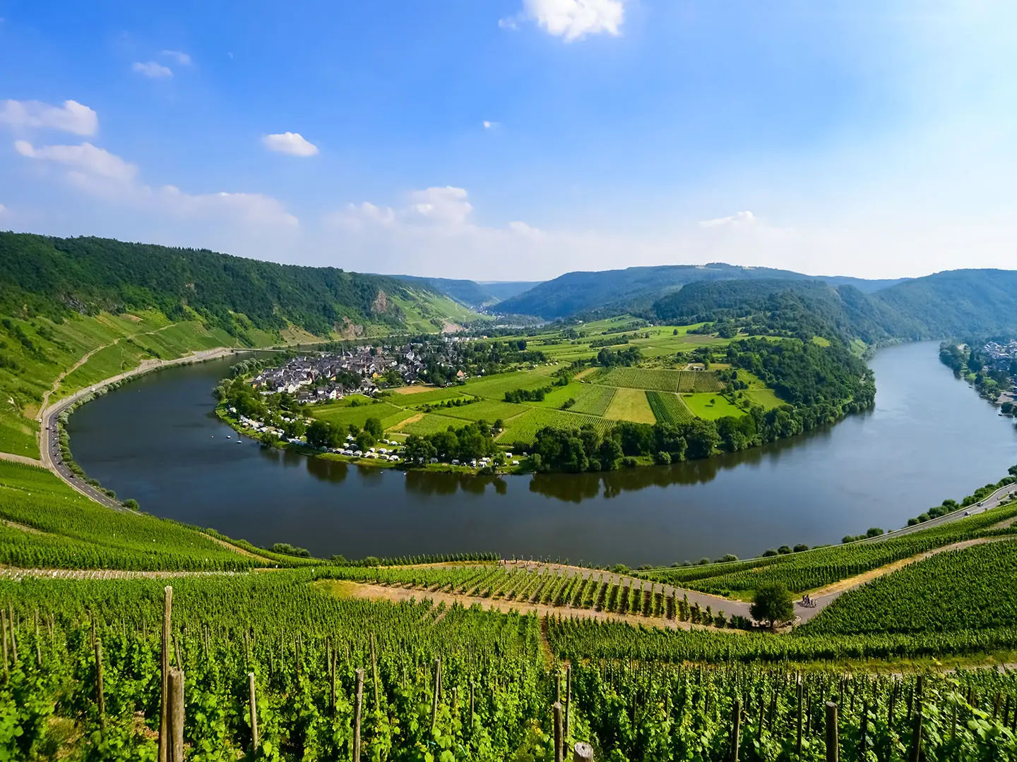
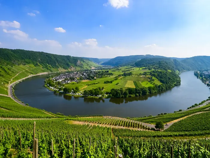
Image by ON-Photography The Moselsteig is a long, waymarked journey through Germany’s Mosel (Moselle) valley, running 365 km from Perl at the German–French–Luxembourg tripoint to the Deutsches Eck in Koblenz. It suits walkers who want a serious multi-day hike with comfortable village-to-village logistics rather than remote mountain hardship.
The trail rarely just follows the riverbank. It climbs repeatedly into vineyards, woods and high terraces, then drops back to wine villages such as Bernkastel-Kues, Zell (Mosel), Beilstein and Cochem.
Its character is part river, part hillside and part cultural route. Roman Trier, the Igeler Säule (Igel Column), Reichsburg Cochem, Burg Eltz and the finish where the Moselle meets the Rhine give the walk far more than scenery alone.
The Moselsteig is not alpine or technical, and the waymarking is a major strength, but it still asks for fitness over 24 official stages. The cumulative climbing is substantial, summer vineyard slopes can be hot, and the Bremmer Calmont section requires sure footing and a head for heights, especially if taking the fixed-rope Klettersteig variant.
This guide covers stages, daily planning, accommodation, food, transport, terrain and the common mistakes to avoid.
Stage-by-Stage Guide
Distances below are approximate and should be treated as planning figures rather than navigation data. The Moselsteig is well waymarked with the Moselsteig M logo, but live diversions, transport timetables, seasonal boat services and accommodation availability should be checked before travelling.
Stage 1: Perl to Palzem — approx. 24 km
The opening stage is one of the longer days, beginning at Perl on the Upper Moselle near the German–French–Luxembourg tripoint. It climbs away from the river through the vineyards above the village, setting the pattern for the whole trail: river-level settlements, vineyard terraces, wooded slopes and repeated height gain.
Expect a mix of narrow hiking paths, vineyard service tracks and forest sections rather than a flat riverside walk. In warm weather, the open vineyard slopes can feel much hotter than the map distance suggests, so start with enough water rather than relying on frequent stops.
Palzem is a wine village and a sensible first overnight stop, with accommodation generally available in the Moselle pattern of guesthouses, small hotels, winery rooms and holiday flats. Perl has rail access on the Trier–Perl regional line; onward transport from Palzem should be checked before travelling.
Navigation is generally straightforward because the trail is purpose-built and waymarked, but the first day is long enough that missed turns in vineyard tracks can cost time. Allow a full walking day if carrying overnight gear.
Stage 2: Palzem to Nittel — approx. 16 km
This is a shorter Upper Moselle stage, continuing through wine country above the river. The walking remains typical Moselsteig terrain: vineyard tracks, dirt paths, forested sections and descents back towards settled valley ground.
The day is less committing than Stage 1, but it still includes climbing away from the river. After rain, wooded paths can be muddy; in summer, exposed south-facing slopes can be dry, bright and hot.
Nittel is a practical overnight halt with the usual Moselle mix of guesthouses, winery accommodation and holiday flats. Food and water are easiest to plan around the start and finish, with any intermediate refreshment options best treated as a bonus unless checked in advance.
Public transport and road access along this part of the valley are generally good by Moselle standards, but exact bus and rail links for the day should be checked before relying on them. The waymarks are the main navigation aid, supported by a GPX track or current map.
Stage 3: Nittel to Konz — approx. 22 km
Stage 3 is a full day and one of the more culturally interesting early sections because it passes the Igeler Säule (Igel Column) in the village of Igel on the approach to Konz. The monument is a richly carved Roman sandstone funerary monument and part of the UNESCO-listed Roman heritage of the region.
The terrain continues to alternate between valley settlements, vineyard slopes, woods and tracks above the Moselle. The length is the main challenge, especially if the day is hot or if conditions are muddy under trees after rain.
Konz is a useful logistical stop and has rail access, making it a good point for joining, leaving or splitting the trail. Accommodation and food options are generally stronger here than in the smaller wine villages, but booking ahead remains sensible during busy weekends.
Navigation through and around settlements can be more fiddly than on open hillside, so pay attention to waymarks at road junctions, vineyard tracks and village exits. Do not expect this stage to feel like a flat approach to Trier; the Moselsteig repeatedly takes the higher line where possible.
Stage 4: Konz to Trier — approx. 21 km
This stage leads into Trier, Germany’s oldest city and one of the major cultural anchors of the Moselsteig. The route passes through the Roman and medieval city fabric, with the Porta Nigra directly on the route.
Before reaching the city, the day still has the characteristic Moselle rhythm of climbs, woodland and vineyard or hillside paths. Underfoot, expect a mixture of dirt paths, gravel, forest tracks and harder surfaces on the approach into Trier.
Trier is one of the best-served places on the entire trail, with extensive accommodation, food and transport options and rail connections. It is also a logical rest-day stop if walking the whole route in one continuous journey.
Urban navigation needs more concentration than the waymarked countryside sections: watch for Moselsteig signs at street corners and where the route threads through built-up areas. Book accommodation early if arriving at a weekend or during a major local event.
Stage 5: Trier to Schweich — approx. 20 km
Leaving Trier, the Moselsteig returns to its familiar mix of river-valley walking, vineyards and wooded heights. Although this is not a technical stage, it is still a proper walking day, with repeated changes between valley level and higher ground.
The walking surface varies from hiking paths and forest tracks to vineyard service ways and occasional hard-surfaced links. In wet weather, woodland sections can be slippery or muddy; in summer, carry enough water before the open vineyard climbs.
Schweich is a practical endpoint with rail access and the usual range of valley services. Food, resupply and accommodation are easier to arrange here than in very small hamlets, but festival and harvest weekends can still tighten availability.
Public transport between Trier and the Moselle villages is useful for shortening stages or creating section walks, though current bus, rail and seasonal boat timetables should be checked. Follow waymarks carefully when leaving Trier, as urban exits are often where long-distance walkers lose time.
Stage 6: Schweich to Mehring — approx. 12 km
Stage 6 is short in distance but important in profile: it crosses the Mehringer Berg, the highest point of the Moselsteig at 416 m. The height is modest by mountain standards, but it underlines how much climbing the route accumulates above the river.
Expect a day of ascent and descent rather than easy riverside mileage. Paths and tracks run through vineyards, woods and higher ground, with broad views when the route breaks out of cover.
Mehring is a straightforward overnight stop in Moselle wine country, with guesthouses, winery rooms, holiday flats and small hotels typical of the route. Because the stage is short, it can be paired with an adjacent section by fit walkers, but doing so adds a meaningful amount of climbing.
Transport options along the valley should be checked against current timetables, especially if using this as a half-day or rest-day stage. Navigation is generally simple on the waymarked trail, but the climb makes pacing more important than the kilometre figure suggests.
Stage 7: Mehring to Leiwen — approx. 15 km
This stage continues through the central Moselle landscape of vineyards, terraces and wooded slopes. The trail again leaves the river to gain viewpoints before descending towards the next wine village.
The underfoot conditions are usually a mix of narrow paths, gravel tracks, vineyard access ways and forest sections. Mud after rain and heat on open slopes are the most relevant conditions to plan for.
Leiwen is another practical wine-village stop with accommodation in the familiar Moselle styles. Food and water planning is simple if based on the start and finish, but do not rely on every small settlement or vineyard area having open services during the walking day.
Public transport along this stretch may involve local buses or seasonal river services rather than simple rail at every village. This should be checked before travelling, particularly outside the main visitor season.
Stage 8: Leiwen to Neumagen-Dhron — approx. 14 km
Stage 8 is a manageable day into Neumagen-Dhron, reputedly Germany’s oldest wine town. The town is known for the Roman Neumagen wine ship tombstone carving, a reminder that wine and river transport have shaped this valley for centuries.
The walking remains varied rather than flat: vineyard terraces, wooded slopes, tracks and paths above the Moselle. The shorter distance makes this a useful day for a slower start, a longer lunch stop or adjusting the pace of a multi-day itinerary.
Neumagen-Dhron has accommodation and food options typical of a well-established Moselle wine town. Book ahead on popular wine weekends, especially in the harvest period.
For transport, check current riverside bus and seasonal boat timetables if not staying overnight. Waymarking is generally strong, but village entries and exits still deserve attention because several lanes and vineyard tracks can look similar.
Stage 9: Neumagen-Dhron to Kesten / Osann-Monzel — approx. 18 km
This stage includes Piesport, one of the Moselle’s best-known Riesling villages, set in a tight river bend. On the slopes, Piesport has a reconstructed Roman wine press, the Römische Kelter, which fits naturally with the Roman wine history seen earlier on the route.
The day is moderately long and continues over the usual mixture of vineyard service paths, dirt tracks, forest paths and descents to river settlements. Open slopes can be very hot in high summer, and the reflected heat from stone and vineyard terraces can make the stage feel harder than its distance.
The official endpoint is commonly treated as Kesten / Osann-Monzel, so check exactly where booked accommodation is located before assuming the day ends at a single centre. Both food and overnight logistics should be arranged in advance if arriving late or outside the main visitor season.
Transport along this middle Moselle section may not be as simple as walking from station to station, so check bus, rail and boat options before using the stage as a day walk. Navigation is mainly by Moselsteig waymarks, with extra care needed around vineyard tracks near Piesport and the end villages.
Stage 10: Kesten / Osann-Monzel to Bernkastel-Kues — approx. 15 km
This stage finishes in Bernkastel-Kues, one of the classic Moselle wine towns. The compact half-timbered Marktplatz and Burg Landshut above the town make it one of the strongest overnight stops on the route.
The walk approaches through vineyard and hillside terrain rather than staying beside the river. Expect a varied day with climbs, descents, forested sections and open views over the Moselle valley.
Bernkastel-Kues has a broad range of accommodation and food options, but it is also popular. Booking ahead is particularly important during wine festivals, holiday periods and harvest weekends.
Public transport and road access are generally good for a major Moselle visitor town, but exact connections should be checked before planning a late arrival or early departure. In and around Bernkastel-Kues, allow time for wayfinding through busier streets and riverside approaches.
Stage 11: Bernkastel-Kues to Ürzig — approx. 17 km
Leaving Bernkastel-Kues, the Moselsteig climbs back into the vineyard and hillside landscape above the river. This is a classic mid-route day: not extreme in distance, but full of the small ascents and descents that define the trail.
Paths can include narrow dirt sections, forest tracks, gravel and vineyard service routes. After rain, the wooded parts may be muddy; on clear summer days, open slopes can be exposed and water demand can be high.
Ürzig is a practical wine-village endpoint with accommodation normally available in guesthouses, winery rooms, holiday flats and small hotels. Evening food should be checked when booking, as opening days and hours can vary in smaller villages.
Transport links in this stretch should be checked before travelling, especially if using local buses or boats to reach accommodation elsewhere. Navigation is usually reliable, but take care at vineyard junctions where several tracks may run in parallel.
Stage 12: Ürzig to Traben-Trarbach — approx. 15 km
This stage continues through the central Moselle, ending in Traben-Trarbach, one of the larger and more useful overnight stops in the valley. The walking is moderate in distance but still includes the route’s usual climbs away from the river.
Expect a mixture of forest, vineyard terrain and tracks above the Moselle before descending towards town. Footing is generally non-technical, though wet woodland and steep vineyard access paths can be tiring.
Traben-Trarbach offers a stronger spread of accommodation and food than many smaller villages, making it a good place to reset supplies. It is also a sensible staging point for walkers splitting the Moselsteig into sections.
Check current transport options before relying on them, particularly where river, bus and rail services do not line up perfectly with walking stages. Within Traben-Trarbach, follow the waymarks carefully through the built-up approach.
Stage 13: Traben-Trarbach to Reil — approx. 15 km
Stage 13 is another moderate-length day through vineyards, woodland and hillside paths above the Moselle. It suits a steady walking pace rather than an early forced march, unless combining stages.
The terrain is not technical, but the constant undulation remains the main physical factor. In poor weather, forest tracks and narrow dirt paths can hold mud; in high summer, start early if the forecast is hot.
Reil is a smaller wine-village overnight stop, so accommodation should be booked rather than left to chance. Food and water are best planned around Traben-Trarbach and Reil unless current opening times along the way have been checked.
Public transport for this stage should be checked before travelling, especially outside the main season. The route is well waymarked, but vineyard junctions and descents into villages require attention.
Stage 14: Reil to Zell (Mosel) — approx. 12 km
This is one of the shorter official stages, finishing at Zell (Mosel). The shorter distance makes it useful for a slower day, for catching up on logistics, or for pairing with another stage if fitness and accommodation plans allow.
The walking remains true to the Moselsteig character, with climbs from river level to vineyard and wooded slopes before returning to the valley. Do not assume the short kilometre count means flat ground.
Zell (Mosel) is a significant valley stop, and rail access for Zell is via Bullay, with onward local connections to be checked. Accommodation and food are generally easier to arrange than in the smallest villages, but advance booking is still sensible at busy times.
Navigation is normally straightforward on the Moselsteig waymarks. If using this as a transport-linked day walk, check the exact connection between Zell (Mosel), Bullay and the walking stage before setting out.
Stage 15: Zell (Mosel) to Neef — approx. 20 km
Stage 15 is a longer day after the short walk into Zell, so allow enough time and water. It continues through the tightening bends and steep vineyard landscapes of the lower Middle Moselle, where the trail often works harder than the river distance suggests.
Expect narrow paths, vineyard tracks, forest sections and repeated climbs and descents. Hot weather can be demanding on open slopes, while shaded woodland can stay muddy after rain.
Neef is a smaller endpoint, so accommodation should be arranged before arrival. If suitable beds are limited, nearby village or transport-linked alternatives may be needed; this should be checked before travelling.
Public transport options in this part of the valley vary by exact village and season, so do not rely on a last-minute exit without checking current timetables. Navigation is good, but the long stage leaves less margin for errors around vineyard junctions.
Stage 16: Neef to Ediger-Eller — approx. 11 km
Stage 16 is short but one of the defining days of the Moselsteig because it traverses the dramatic terrain beside the Bremmer Calmont. The Calmont is reputedly Europe’s steepest vineyard, with slopes reaching about 65 degrees, and the terrain here feels more exposed than most of the route.
The main Moselsteig remains a hiking route rather than an alpine climb, but this is the stage where sure footing and a head for heights matter most. The optional Calmont-Klettersteig variant includes fixed-rope sections and should only be used in suitable conditions by walkers comfortable with steep, exposed ground.
Check current Calmont-Klettersteig conditions and any access advice before committing to the variant. In wet weather, on very hot days, or if carrying a heavy pack, the safer signed walking line may be the better choice.
Ediger-Eller is a practical end point with accommodation in the usual Moselle styles, but book ahead because this is a popular section. Food and water should be planned carefully: the day is short, but the terrain is slow and heat on the Calmont slopes can be intense.
Stage 17: Ediger-Eller to Beilstein — approx. 16 km
This stage continues through steep vineyard and wooded Moselle scenery to Beilstein. Beilstein is one of the smallest and most picturesque villages on the route, with the ruins of Burg Metternich above the river.
The walking is moderate in distance but remains undulating, with vineyard tracks, paths and descents to village level. After the Calmont stage, this is less exposed, but the route still rewards steady pacing and secure footwear.
Beilstein has accommodation and food options, but its small size makes advance booking especially important. If staying outside the village, check local transport or taxi arrangements before walking in.
Navigation is generally simple on the waymarked trail, though village approaches can be busy in visitor season. Carry enough water from Ediger-Eller if walking in hot weather, as open slopes can still be demanding.
Stage 18: Beilstein to Cochem — approx. 14 km
Stage 18 ends in Cochem, one of the best-known towns on the Moselle. Reichsburg Cochem, the neo-Gothic hilltop castle with medieval origins, dominates the approach and gives this stage a strong finish.
The walk is not long, but it continues over the usual elevated vineyard and wooded terrain before dropping towards town. Expect mostly non-technical paths and tracks, with some harder surfaces near settlements.
Cochem is a major logistical point on the lower Moselle, with rail access, extensive accommodation and plenty of food options. It is a good place for a rest night, resupply or joining/leaving the trail.
Urban navigation on the way into Cochem needs attention because the route passes from hillside paths into a busier town environment. Book ahead in popular periods; Cochem can fill quickly compared with quieter villages.
Stage 19: Cochem to Treis-Karden — approx. 24 km
This is one of the longest official stages, so it should be treated as a full walking day. The distance, combined with the Moselsteig’s regular climbing and descending, makes it more demanding than a simple riverside 24 km.
The terrain remains a mix of forest paths, dirt and gravel tracks, vineyard routes and descents to valley settlements. In wet weather, muddy woodland can slow progress; in summer, exposed sections can require more water than expected.
Treis-Karden is a practical overnight stop with valley accommodation options. Because the stage is long, secure a bed and know the latest check-in time before leaving Cochem.
Cochem has strong public transport access, but onward options at the end of the stage should be checked before relying on them. Navigation is generally reliable, yet this is not a day to be casual with waymarks, as small detours can become tiring late in the stage.
Stage 20: Treis-Karden to Moselkern — approx. 14 km
Stage 20 is one of the major highlight stages because the route follows the Elzbach valley and passes the Fünfhundert-Mark-Blick viewpoint of Burg Eltz. The castle itself is reached by a very short detour off the path and is one of the most memorable cultural sights on the Moselsteig.
The terrain is more enclosed and wooded than some vineyard-heavy stages, with paths and tracks through the side valley as well as Moselle-side approaches. After rain, expect mud and potentially slippery woodland sections.
Moselkern is a smaller end point, so accommodation should be booked in advance. If planning time for the Burg Eltz detour or visit, start early enough to avoid arriving late without food arrangements.
Transport and road access should be checked before travelling, especially if treating Burg Eltz as a day-walk objective. Navigation around the castle detour and viewpoint area is the main place to stay alert; follow the Moselsteig waymarks if continuing directly to Moselkern.
Stage 21: Moselkern to Löf — approx. 14 km
This lower Moselle stage returns to the established rhythm of wooded slopes, vineyard areas and descents between river villages. The distance is moderate, making it a useful recovery day after the Burg Eltz stage if time was spent on the detour.
The path surfaces are varied but generally non-technical: narrow trails, forest tracks, gravel and vineyard service ways. Mud after rain and heat on open slopes remain the most relevant conditions.
Löf is a small Moselle endpoint with accommodation in the usual guesthouse, hotel, winery-room and holiday-flat mix. Book ahead rather than assuming late availability, particularly at weekends.
Public transport along the lower valley can help with stage adjustments, but exact services should be checked before travelling. Navigation is straightforward on the waymarked trail, with care needed at vineyard and village junctions.
Stage 22: Löf to Kobern-Gondorf — approx. 14 km
Stage 22 continues along the lower Moselle towards Kobern-Gondorf. The walking remains a balance of hillside paths, vineyards, woods and valley settlement links rather than a flat riverside promenade.
The moderate distance makes this a manageable day, but the cumulative ascent of the Moselsteig is still felt in the repeated climbs. Carry enough water in hot weather and expect muddy patches in woodland after rain.
Kobern-Gondorf is a practical overnight halt with accommodation and food options typical of the route. As with other smaller valley stops, opening times and evening meals should be checked when booking.
Transport and road access are generally useful along this lower section, but current timetables should be checked before relying on a specific connection. The trail is well signed; still, pay attention where the route leaves valley streets for vineyard or forest tracks.
Stage 23: Kobern-Gondorf to Winningen — approx. 14 km
This penultimate stage keeps the Moselsteig on its elevated, view-seeking line above the river. It is moderate in length but still includes climbs and descents rather than an easy approach to Koblenz.
Expect the usual combination of narrow hiking paths, forest tracks, gravel and vineyard service ways. In summer, this lower Moselle terrain can be hot on exposed slopes, so avoid underestimating the stage because of its distance.
Winningen is the final overnight stop before Koblenz and has the accommodation styles common along the Moselle. Book ahead if finishing over a weekend or during wine events, as beds in attractive river villages can be in high demand.
Public transport options into and out of the lower valley should be checked against current timetables. Navigation is generally simple on the Moselsteig waymarks, but take care not to relax too early before the final day.
Stage 24: Winningen to Koblenz — approx. 14 km
The final stage leads from Winningen to Koblenz and finishes at the Deutsches Eck, the headland where the Moselle flows into the Rhine. The Kaiser Wilhelm I equestrian monument marks the end of the route, with Festung Ehrenbreitstein visible on the far bank.
The walking still follows the Moselsteig pattern before entering the urban finish: hillside paths and valley approaches, then built-up navigation into Koblenz. Expect more hard surfaces and town walking as the route nears the Deutsches Eck.
Koblenz is a major transport hub on the Rhine and one of the easiest places on the route for onward travel. Accommodation, food and rail connections are plentiful, though central beds can still be busy during events and holiday periods.
Urban navigation is the main consideration on the final kilometres. Keep following the Moselsteig waymarks through Koblenz rather than simply aiming for the riverside, and allow enough time at the finish for onward connections.
Recommended Itinerary
Standard itinerary: 24 walking days
The most straightforward way to walk the Moselsteig is to follow the official 24-stage structure from Perl to Koblenz. This keeps navigation and booking simple: each day ends in a recognised Moselle town or wine village, with the shorter stages acting as useful recovery days between longer climbs out of the valley.
| Day | From | To | Approx. distance | Why this stage makes sense | Services/accommodation notes |
|---|---|---|---|---|---|
| 1 | Perl | Palzem | 24 km | A full opening day from the tripoint area, with the route climbing away through Upper Moselle vineyards rather than staying flat by the river. | Book the first night in Perl before starting. Palzem is the official stage end; check accommodation before committing, especially at busy wine-weekend periods. |
| 2 | Palzem | Nittel | 16 km | A more moderate second day after the long opener, keeping the early itinerary sustainable. | Nittel is a wine village stop. Evening meal and bed availability should be checked before travelling. |
| 3 | Nittel | Konz | 22 km | A longer day into the Trier/Konz area, passing the Igeler Säule (Igel Column) on the approach. | Konz is one of the better transport points on the route and works well if joining or leaving the trail for a section. |
| 4 | Konz | Trier | 21 km | A substantial but logical stage into Trier, one of the major cultural and transport anchors of the whole route. | Trier has the broadest choice of accommodation so far and is a good place to add a rest night if wanted. |
| 5 | Trier | Schweich | 20 km | Leaves the city and returns to the rhythm of river, vineyards and wooded heights. | Schweich is served by the Moselle transport corridor, making it a practical overnight and section-hiking point. |
| 6 | Schweich | Mehring | 12 km | A deliberately short stage over the high ground around Mehringer Berg, the high point of the Moselsteig. | Useful recovery day. Mehring has village accommodation, but book ahead in season. |
| 7 | Mehring | Leiwen | 15 km | Keeps the middle Moselle walking measured after the previous day’s climbing. | Leiwen is a wine-village overnight; do not assume last-minute rooms on harvest or festival weekends. |
| 8 | Leiwen | Neumagen-Dhron | 14 km | A short-to-moderate day into one of the route’s notable wine-history stops. | Neumagen-Dhron is a sensible overnight with accommodation in the wine-village pattern of the route. |
| 9 | Neumagen-Dhron | Kesten / Osann-Monzel | 18 km | A standard mid-length stage through classic Moselle vineyard terrain, with Piesport on this section. | The official endpoint is given as Kesten / Osann-Monzel. Choose accommodation carefully and check the exact location against the next morning’s route. |
| 10 | Kesten / Osann-Monzel | Bernkastel-Kues | 15 km | A manageable day into one of the best-known Moselle towns, with time to arrive without rushing. | Bernkastel-Kues has a strong accommodation base and is an excellent place for a rest night. Book early at busy times. |
| 11 | Bernkastel-Kues | Ürzig | 17 km | Leaves a major town but keeps the distance moderate, with more vineyard climbs and river views. | Ürzig is a smaller overnight stop; confirm accommodation and evening food before booking the stage. |
| 12 | Ürzig | Traben-Trarbach | 15 km | A moderate day ending in another substantial Moselle town. | Traben-Trarbach is a practical resupply and accommodation stop, and a good place to pause if not staying an extra night in Bernkastel-Kues. |
| 13 | Traben-Trarbach | Reil | 15 km | A balanced stage that avoids overloading the central section of the trail. | Reil is a smaller wine village; pre-booking is sensible. |
| 14 | Reil | Zell (Mosel) | 12 km | A short day that helps bank energy before the Calmont and lower Moselle stages. | Zell (Mosel) is a recognised valley town and, via Bullay, has useful transport access for section hikers. |
| 15 | Zell (Mosel) | Neef | 20 km | A fuller walking day after the short approach to Zell. | Neef is the overnight before the Calmont stage; check the next day’s weather and any trail information before setting off. |
| 16 | Neef | Ediger-Eller | 11 km | Short on distance but important in terrain: this is the Bremmer Calmont section, where steep, rocky and mildly exposed ground is the main consideration. | Do not treat the short distance as an easy rest day. The fixed-rope Calmont-Klettersteig variant requires sure footing and a head for heights; current conditions should be checked before travelling. |
| 17 | Ediger-Eller | Beilstein | 16 km | A moderate follow-on stage after the Calmont, ending in one of the most attractive small villages on the route. | Beilstein is small and popular; accommodation should be booked well ahead. |
| 18 | Beilstein | Cochem | 14 km | A short-to-moderate day into Cochem, with Reichsburg Cochem dominating the approach area. | Cochem is one of the easiest places on the route for accommodation, services and transport. It is a sensible rest-night option. |
| 19 | Cochem | Treis-Karden | 24 km | One of the longer official days, best tackled after a night in a larger service town. | Start early if it is hot. Treis-Karden is the official overnight; book ahead and check evening food arrangements. |
| 20 | Treis-Karden | Moselkern | 14 km | A moderate day that sets up the Burg Eltz section above Moselkern. | Moselkern is the overnight for walkers wanting time around Burg Eltz; accommodation should be arranged in advance. |
| 21 | Moselkern | Löf | 14 km | Keeps the lower Moselle section comfortably paced after the Burg Eltz area. | Löf is a smaller valley stop; confirm accommodation before relying on it. |
| 22 | Löf | Kobern-Gondorf | 14 km | Another steady lower Moselle stage, maintaining short daily distances as the route approaches Koblenz. | Kobern-Gondorf is a practical overnight in the final part of the trail. |
| 23 | Kobern-Gondorf | Winningen | 14 km | A final short stage before the finish day, avoiding an overlong push into Koblenz. | Winningen is the last overnight before Koblenz; book early at popular wine periods. |
| 24 | Winningen | Koblenz | 14 km | A compact finishing day to the Deutsches Eck, where the Moselle meets the Rhine. | Koblenz is a major transport hub and the easiest place to plan onward travel or an extra night after finishing. |
Slower variant: 26–28 days
A slower itinerary suits walkers who want time in the main towns, prefer not to rush vineyard climbs in hot weather, or are using the Moselsteig as a relaxed inn-to-inn walk rather than a continuous endurance hike.
Keep the 24 official walking stages, but add rest or half-rest nights at the most useful points:
| Extra night | Best placed at | Why it helps |
|---|---|---|
| After Day 4 | Trier | Gives time for Roman Trier and breaks the first five consecutive 20 km-plus days. |
| After Day 10 or Day 12 | Bernkastel-Kues or Traben-Trarbach | Creates breathing space in the central Moselle section, where towns, wine villages and transport links make logistics easier. |
| After Day 18 | Cochem | Useful before or after the longer Cochem to Treis-Karden stage, and practical for resupply and onward transport if section hiking. |
| After Day 24 | Koblenz | Makes the finish at the Deutsches Eck less rushed and simplifies onward travel. |
Slower walkers should be cautious about the 24 km stages from Perl to Palzem and Cochem to Treis-Karden. If those days feel too long, split options depend on current accommodation and transport in the valley; check official mapping and local timetables before booking.
Faster variant: 20–22 walking days
A faster itinerary suits fit walkers who are comfortable with back-to-back hill days and who can handle longer distances despite the constant climbs from river level to vineyard terraces and wooded heights. The Moselsteig is not alpine, but combining stages can turn otherwise moderate days into long, tiring outings.
The safest way to shorten the route is to combine only selected shorter adjacent stages, rather than compressing the entire walk aggressively. Sensible candidates include:
| Combined day | Approx. distance | Comment |
|---|---|---|
| Schweich to Leiwen, combining Days 6–7 via Mehring | 27 km | Long but logical if starting early; includes the high-ground section around Mehringer Berg. |
| Traben-Trarbach to Zell (Mosel), combining Days 13–14 via Reil | 27 km | A practical central-route combination for strong walkers. |
| Neef to Beilstein, combining Days 16–17 via Ediger-Eller | 27 km | Only suitable in good conditions and for walkers comfortable with the Calmont section; do not rush this day. |
| Treis-Karden to Löf, combining Days 20–21 via Moselkern | 28 km | A long lower Moselle day that should still leave time for the Burg Eltz area only if starting early. |
Using two to four of these combinations gives a roughly 20–22 day walk while preserving the overall structure of the official route. Accommodation must be booked to match the revised endpoints, and current transport options should be checked before relying on a fallback plan.
Planning the Route
How many days to allow
The simplest plan is to walk the Moselsteig as designed: 24 walking days from Perl to Koblenz, using the stage towns as overnight stops. That pace suits most walkers because the trail repeatedly climbs away from the Mosel/Moselle to vineyard terraces and wooded heights, so even moderate distances can feel more tiring than a flat riverside walk.
Fast walkers can reduce the schedule by combining some of the shorter middle and lower-valley stages, especially where consecutive days are around 11–15 km. The trade-off is that combined days can become slow if they include steep vineyard climbs, hot open slopes or longer cultural stops in places such as Trier, Bernkastel-Kues, Cochem or Burg Eltz.
A relaxed itinerary is often the better fit for this route. The Moselsteig is strongest as an inn-to-inn trail through wine villages, viewpoints and historic towns, and rushing it removes much of the practical advantage of having frequent accommodation, food and transport close to the route.
Using the stage towns
Daily stages are naturally dictated by settlements. The route passes a near-continuous chain of river towns and wine villages, so most walkers can plan nights in or near the published stage endpoints rather than needing remote accommodation transfers.
The main exception is not a lack of places to stay, but availability. Popular wine villages can fill on festival and harvest weekends, so accommodation should be booked ahead for busy periods, especially if walking a fixed 24-day schedule with little flexibility.
The published stage pattern is also useful because the distances vary deliberately. Longer days such as Perl to Palzem, Nittel to Konz, Konz to Trier and Cochem to Treis-Karden are balanced by shorter days elsewhere, including several stages of roughly 11–15 km.
Shortening, extending and rest days
Shortening the Moselsteig is practical because many towns are linked by rail, riverside buses and, in season, Moselle boats. The railway is particularly useful around larger valley points such as Koblenz, Cochem, Bullay for Zell, Trier, Konz and Schweich, while Perl is reached by the Trier–Perl regional line.
Timetables for trains, buses and seasonal boats should be checked before travelling, especially where the railway leaves the immediate riverside and onward travel depends on buses or boats. Do not assume that an evening connection will always suit a long walking day.
Rest days are easiest in the larger towns with rail access and a wider choice of accommodation. Trier, Bernkastel-Kues, Traben-Trarbach, Cochem and Koblenz are logical places to slow the itinerary, though the best choice depends on where beds are available and how the onward transport fits.
Walkers wanting extra distance can add one of the Moselsteig side loops, known as Seitensprünge or Moselsteig-Partnerwege. These circular routes branch from the main trail and range from short add-ons to longer day walks, so they are best treated as optional extras rather than built into a tight end-to-end schedule.
Section hiking
The Moselsteig is well suited to section hiking. Public transport along the valley makes it realistic to walk a few stages at a time, return to a rail hub, and continue later without needing private transfers.
Useful section anchors include Trier for the upper and middle valley, Bullay for Zell, Cochem for the lower central valley, and Koblenz for the final stages. Perl is the natural access point for starting the full route, but service times should be checked before fixing travel plans.
For a first shorter section, choose a run of stages where accommodation and transport are both straightforward rather than choosing purely by highlights. The trail’s climbing pattern means a short kilometre total can still make a full walking day.
What matters most when planning
| Planning point | What to do |
|---|---|
| Accommodation | Book stage towns ahead in busy wine villages, particularly during festival and harvest weekends. Hotels, Gasthöfe/Pensionen, winery rooms, holiday flats, hostels and campsites are all part of the accommodation mix. |
| Food and resupply | Resupply is generally straightforward because the route repeatedly drops into towns and villages. Still carry enough food for the day when the path climbs onto vineyard terraces or through woods away from services. |
| Water | Carry more water than the map distance suggests in hot weather. South-facing vineyard slopes can be very exposed in summer, and the trail often spends hours above the river rather than beside it. |
| Navigation | The Moselsteig is thoroughly waymarked with the “M” logo, but a map or GPX track is still sensible for diversions, town exits and bad weather. Official stage maps, guide material and digital route planners are available for the trail. |
| Transport | Use rail, buses and seasonal boats to build shorter sections, skip a stage if needed or return to a base town. Current timetables should be checked before travelling. |
| Weather | Heat is the main summer planning issue on open vineyard slopes; mud can slow wooded sections after rain. Start early on hot days and avoid underestimating the climbs out of the valley. |
| Steep ground | Stage 16 around the Bremmer Calmont needs particular attention. The main Moselsteig is a hiking route, but the optional Calmont-Klettersteig variant is steeper, partly fixed-rope, and requires sure footing and a head for heights; current conditions should be checked before committing to it. |
| Permits and closures | The main planning burden is accommodation and transport rather than permits. Any live trail diversions, attraction access or campsite requirements should be checked before travelling. |
Practical itinerary advice
Plan the route from bed to bed, not just from distance to distance. A 14 km Moselsteig day can include repeated ascent from the river, open sun and a slow descent into the next village, while a longer valley-linked day may be easier to shorten by transport if required.
Avoid building an itinerary that depends on combining too many short stages in a row. This is possible for fit walkers, but it leaves less margin for heat, winery-town accommodation constraints, castle visits, or the slower terrain around places such as the Calmont and the Elzbach valley near Burg Eltz.
For a full end-to-end walk, book the first few and most popular nights early, then keep some flexibility where transport options are good. For a fixed-holiday schedule, decide in advance which stages can be skipped or joined by train, bus or boat if weather, fatigue or accommodation availability changes the plan.
Towns, Villages and Overnight Stops
The Moselsteig is unusually straightforward for inn-to-inn planning because the official stages end in a close chain of Moselle wine towns and villages. Hotels, Gasthöfe, Pensionen, Weingut rooms, holiday flats, hostels and campsites are all part of the accommodation mix, but availability is uneven: small villages can feel well supplied on a normal weekday and fully booked on wine-festival or harvest weekends.
Food and resupply are easiest in the larger towns. In smaller villages, restaurants, cafés and shops should not be assumed to open late, every day, or outside the main visitor season. If a stage finish matters for dinner or onward transport, this should be checked before travelling.
Perl
Perl is the official start, on the Upper Moselle at the German–French–Luxembourg tripoint. It is the sensible place to stay the night before starting if you want an unhurried first morning, as stage 1 is one of the longer days at about 24 km and climbs away from the river through vineyards above the village.
Perl is on the Trier–Perl regional railway, making it practical for arrival by public transport. Accommodation should still be booked in advance rather than left to arrival day, especially if starting at a weekend.
Palzem
Palzem is the first official overnight stop, reached from Perl after a full day. It works well as a natural halt if following the 24-stage itinerary, but it is a smaller river village rather than a large service centre.
Expect village-scale accommodation and food options, with less flexibility than in Trier or Koblenz. If arriving late after the long first stage, dinner arrangements and check-in times should be confirmed beforehand.
Nittel
Nittel is the stage 2 finish and another practical wine-village overnight. The previous day from Palzem is shorter than stage 1, so it can be a more relaxed stop if accommodation is available.
It is a useful place to keep to the official rhythm before the route continues towards Konz and Trier. Local food options and shops should be checked in advance, particularly outside the main walking and wine season.
Konz
Konz is the stage 3 endpoint and a more useful transport stop than the smaller villages before it. It is one of the valley towns served by regional rail, and it also sits conveniently before the route into Trier.
For hikers section-walking the early Moselsteig, Konz is a practical access or exit point. It can also be used as an overnight alternative to Trier if accommodation in the city is expensive or full, though Trier has the broader choice of beds, food and onward connections.
Trier
Trier is one of the most useful overnight stops on the entire route. It is the stage 4 finish, a major rail hub near the start section, and the best place early on the trail for a rest day, equipment replacement, laundry or a more flexible choice of accommodation.
The route passes through the Roman city, including the Porta Nigra area, so staying here also avoids rushing one of the main cultural stops. Trier is a good place to reset food plans before the route continues down-valley into smaller wine villages.
Schweich
Schweich is the stage 5 finish and is served by the Moselle valley rail network. It is a practical overnight after leaving Trier, with better transport options than many of the smaller stage villages.
The following stage to Mehring is short, but it crosses the high ground around Mehringer Berg, the highest point of the Moselsteig. Schweich therefore works well for hikers who want to keep the official daily structure rather than push on too far out of Trier.
Mehring
Mehring is the stage 6 finish after one of the shorter official days. It is a useful overnight if you are pacing the walk conservatively or want a lower-mileage day after the Trier and Schweich sections.
Accommodation is in the typical Moselle mix of village inns, guesthouses and wine-related stays. Because the stage into Mehring is short, some fit walkers may combine it with the next day, but that depends on accommodation, heat and how much climbing is being tolerated.
Leiwen
Leiwen is the stage 7 endpoint and a practical wine-village stop between Mehring and Neumagen-Dhron. It suits walkers staying close to the official itinerary and wanting short-to-moderate days rather than doubling stages.
Services should be treated as village-scale. Book a bed and confirm food options before relying on an evening arrival.
Neumagen-Dhron
Neumagen-Dhron is the stage 8 finish and one of the more distinctive cultural stops, known for its Roman wine history and the Neumagen wine ship motif. It is a worthwhile overnight rather than just a pass-through if the schedule allows.
As a recognised wine town, it has the typical Moselle accommodation pattern, but weekends can still fill. It is also a sensible place to check the next day’s arrangements, as stage 9 continues through the Piesport area before ending at Kesten / Osann-Monzel.
Kesten
Kesten is part of the official stage 9 endpoint, listed with Osann-Monzel. It is a small wine village and works as a quiet overnight if accommodation is available.
Do not assume the same range of services as in Bernkastel-Kues, which comes the following day. If staying here, confirm dinner and breakfast arrangements with the accommodation, especially outside the busiest season.
Osann-Monzel
Osann-Monzel is paired with Kesten in the stage 9 / stage 10 transition and is a useful alternative overnight in the same part of the route. It is particularly relevant if beds in Kesten are full or if the chosen accommodation sits better for the next morning’s start.
This is not a place to leave logistics vague. Check the exact location of the accommodation against the trail line, and confirm local food options before booking.
Bernkastel-Kues
Bernkastel-Kues is one of the best overnight stops on the Moselsteig. It is the stage 10 finish, a classic Moselle wine town, and a strong choice for a rest evening or shorter resupply pause.
The town has a broader accommodation and food base than the surrounding villages, but it is also popular. Book early for weekends, wine events and the harvest period, as this is exactly the kind of place where walkers and general visitors compete for the same rooms.
Ürzig
Ürzig is the stage 11 finish, reached after the route leaves Bernkastel-Kues. It is a smaller wine village stop and a useful halt before the walk continues towards Traben-Trarbach.
Accommodation should be arranged ahead rather than improvised. If public transport is needed from here, current local bus, rail or boat connections should be checked before travelling.
Traben-Trarbach
Traben-Trarbach is the stage 12 finish and one of the more substantial overnight bases in the middle part of the Moselsteig. It is a good place to pause, sort laundry, eat properly and reset the next few bookings.
For public transport, do not rely on assumptions: the Moselsteig corridor is well served overall by rail, riverside buses and seasonal boats, but exact connections vary by place and date. Current timetables should be checked before using Traben-Trarbach as a start, finish or rest-day base.
Reil
Reil is the stage 13 finish and a smaller village stop before the short day to Zell (Mosel). It is suitable for a standard overnight on the official itinerary, especially if you prefer not to combine stages.
Food and accommodation are best confirmed in advance. If Reil is full, nearby alternatives may be possible, but any off-stage adjustment should be checked against transport and the next day’s walking distance.
Zell (Mosel)
Zell (Mosel) is the stage 14 finish and a useful practical stop before the longer stage to Neef. For rail logistics, Bullay is the named rail access point for Zell, so onward transport plans should be built around current connections there rather than assumed from the village itself.
Zell is a better resupply and overnight candidate than many smaller villages in this section. It is a sensible place to prepare for the next day, which is about 20 km on the official schedule.
Neef
Neef is the stage 15 finish and an important overnight because it sits immediately before the Calmont section. Staying here sets up stage 16 to Ediger-Eller without needing to approach the steepest and most exposed part of the route late in the day.
Accommodation and meals should be booked ahead. If planning to use the optional Bremmer Calmont Klettersteig variant rather than the standard trail, current conditions and access should be checked before travelling.
Ediger-Eller
Ediger-Eller is the stage 16 finish after the Calmont day. It is a particularly useful place to have a confirmed bed, as this stage contains the steep, narrow and mildly exposed terrain that many walkers will not want to rush.
The village works well for recovery after the hardest technical-feeling section of the Moselsteig. If the weather is hot, or if the Calmont has taken longer than expected, having dinner and check-in arranged in advance is valuable.
Beilstein
Beilstein is the stage 17 finish and a very small, popular village below Burg Metternich. It is one of the most atmospheric stops on the route, but its size means accommodation can be tight.
Book early if aiming to stay here, especially on weekends. If beds are unavailable, Cochem comes the following day and has a much larger service base, but changing the overnight plan will affect the stage spacing.
Cochem
Cochem is the stage 18 finish and one of the main logistical anchors of the lower Moselle. It is served by the Koblenz–Trier rail corridor and has a much broader choice of accommodation, food and services than the neighbouring villages.
It is a strong choice for a rest night before stage 19, which is one of the longest official days at about 24 km to Treis-Karden. Reichsburg Cochem also makes it a worthwhile stop in its own right, rather than just a practical town.
Treis-Karden
Treis-Karden is the stage 19 finish after the long day from Cochem. It is a useful overnight because pushing beyond it would turn an already substantial stage into an unnecessarily hard day.
Accommodation should be reserved, particularly if arriving tired after the 24 km stage. Check food arrangements if planning a late finish, as smaller-town evening options can be more limited than in Cochem or Koblenz.
Moselkern
Moselkern is the stage 20 finish and the key village for the Burg Eltz section. The route from Treis-Karden follows the Elzbach valley and passes the Burg Eltz viewpoint, with the castle itself reached by a very short detour off the path.
For hikers wanting time at Burg Eltz, Moselkern is the logical overnight rather than rushing onwards. Accommodation and local food options should be confirmed before arrival.
Burg Eltz (beside the route)
Burg Eltz is a major highlight beside stage 20, not a normal overnight stop. Treat it as a sightseeing detour and viewpoint section within the walking day, with Moselkern, Treis-Karden or the following stage villages used for accommodation planning.
Allow schedule flexibility here if visiting the castle matters. Opening times, access details and any local path diversions should be checked before travelling.
Löf
Löf is the stage 21 finish and a compact lower-Moselle overnight. It keeps the final part of the route neatly divided into moderate days towards Kobern-Gondorf, Winningen and Koblenz.
Services are more limited than in Cochem or Koblenz, so book beds and meals ahead. If using public transport to skip, join or shorten this section, current valley bus, rail and boat timetables should be checked.
Kobern-Gondorf
Kobern-Gondorf is the stage 22 finish and a practical stop two walking days before Koblenz. It is useful for maintaining the official rhythm through the lower valley without making the approach to Koblenz too long.
Accommodation is part of the wider Moselle village pattern, but choice can still be limited on busy weekends. Confirm the exact location of your lodging against the trail, as river-valley settlements can be spread along the water.
Winningen
Winningen is the final overnight village before Koblenz, at the end of stage 23. It is a good last stop if you want to arrive at the Deutsches Eck during the following day rather than late in the evening.
Because Koblenz is close in trail terms, some walkers may choose to continue to the finish if fitness, daylight and accommodation plans allow. For most itineraries, staying in Winningen keeps the final stage relaxed and avoids rushing the end of the route.
Koblenz
Koblenz is the official finish at the Deutsches Eck, where the Moselle meets the Rhine below the Kaiser Wilhelm I monument. It is the best end-point for onward travel, with Koblenz acting as a major rail hub on the Rhine as well as the Moselle corridor.
Accommodation, food and transport choice are far broader here than in the wine villages. It is worth booking a final night if finishing late, meeting non-walking companions, or building in a buffer for delayed stages earlier on the route.
Getting to the Start
The Moselsteig starts in Perl, Saarland, on the Upper Moselle (Obermosel) at the German–French–Luxembourg tripoint. Stage 1 then climbs away from the river through the vineyards above the village, so plan to arrive the day before if walking the full 24 km first stage to Palzem.
By train
Perl is on the Trier–Perl regional rail line, making train travel the simplest way to reach the start without a car. Trier is the practical rail hub for most walkers starting the route, with onward regional trains to Perl.
For international or long-distance arrivals, route to Trier first, then continue by regional train to Perl. Koblenz is the major rail hub at the finish and has fast connections on the Rhine, but it is better used for the end of the walk or for returning home after completing the trail.
Check current rail times carefully before booking accommodation, especially for early starts, weekend services and public holidays. This should be checked before travelling.
By bus
Bus services are useful along parts of the Moselle valley, particularly where the railway leaves the river, but Perl is best approached by train via Trier. Local buses may help with short hops between nearby villages or accommodation, but they should not be assumed to run frequently enough for a tight start-day plan.
If staying outside Perl the night before, check the first bus or train of the morning before committing to accommodation. This should be checked before travelling.
By car
Driving to Perl is possible, but the Moselsteig is a point-to-point trail ending 365 km later in Koblenz, so a car creates an end-of-walk logistics problem. If using a car, the usual options are to leave it near the start and return from Koblenz by rail via Trier, or to park at/near the finish and travel to Perl before starting.
Do not rely on informal long-stay parking in a small wine village without checking. Ask accommodation in Perl, or the relevant local parking authority, whether multi-day parking is permitted and whether any time limits apply. This should be checked before travelling.
A taxi can be useful for the final short link between accommodation, the station and the exact start area, particularly if arriving late or carrying a full pack. Availability in smaller Moselle villages can be limited, so book ahead rather than expecting taxis to be waiting at the station.
From the nearest airport
The nearest larger airport options for the Moselsteig start are Luxembourg, Frankfurt-Hahn, Frankfurt and Cologne/Bonn. For most walkers, the practical aim is to reach Trier, then take the regional train onward to Perl.
Airport transfer choices vary by airport and season, especially for Frankfurt-Hahn and regional bus links. Check the full airport-to-Trier-to-Perl connection before booking flights, and leave margin for delays if planning to walk on the same day. This should be checked before travelling.
Where to stay before starting
The most convenient pre-start base is Perl itself, as it allows an early start on the long first stage to Palzem. Staying in Perl also removes the risk of a missed morning connection from Trier.
Trier is the better choice if arriving late by long-distance train or wanting a wider range of services before beginning. In that case, take the regional train to Perl on the morning of day 1, but check that the timetable still gives enough daylight for the full stage.
Accommodation is generally plentiful along the Moselle, including hotels, guesthouses, winery rooms and holiday flats, but popular wine villages can fill during festival and harvest weekends. Book the first night and the first few stage-end nights in advance if walking in peak season.
Getting Home from the Finish
The Moselsteig finishes at the Deutsches Eck in Koblenz, where the Moselle meets the Rhine. Koblenz is the easiest possible finish point for this trail: it is a major rail hub, so onward travel is far simpler than from many of the smaller Moselle villages earlier on the route.
By train
Koblenz is the main onward transport point at the finish. The city has fast rail connections on the Rhine corridor, and regional services also link back along the Moselle towards towns such as Cochem, Bullay, Trier, Konz, Schweich and Perl.
For walkers who started with a car or luggage left near the beginning, the practical rail return is usually Koblenz → Trier, then onward on the Trier–Perl regional line. Exact routings, changes and late-evening services are timetable-dependent and should be checked before travelling.
If finishing late in the day, do not assume there will be a convenient same-evening connection all the way back to Perl or to a smaller Moselle village. Koblenz is large enough for an overnight stop, and staying in the city is often the most relaxed option after the final stage from Winningen.
By bus
Local buses can be useful for short hops within Koblenz, especially if the walk from the Deutsches Eck to the rail station or accommodation is not appealing after 24 stages. Route numbers, stops and evening/Sunday frequencies should be checked before travelling.
For longer movements along the Moselle, the railway is usually the more straightforward option from Koblenz. Riverside buses are more relevant in sections of the valley where the railway leaves the river, rather than for leaving the finish itself.
By car/taxi
A taxi is the simplest fallback for getting from the Deutsches Eck to accommodation or the station in Koblenz, particularly in bad weather, with heavy luggage, or after a late finish. For any longer taxi transfer back along the Moselle or towards Perl, arrange it in advance and confirm the fare before committing.
If using a parked car, Koblenz works best as the endpoint rather than the starting parking location: leave the car near the finish, travel to Perl at the start by rail, then walk back to it. If the car has been left in Perl, plan the rail return from Koblenz via Trier and then Perl, allowing enough time for connections.
From the nearest airport
The larger airports relevant to the Moselsteig are Frankfurt-Hahn, Luxembourg, Frankfurt and Cologne/Bonn. From the finish, Koblenz’s rail links make Frankfurt and Cologne/Bonn the most straightforward airport directions to investigate first, but actual airport access depends on current rail and airport-connection timetables.
Frankfurt-Hahn and Luxembourg can also be relevant depending on flight availability and wider travel plans, but onward public transport from Koblenz should be checked carefully before booking flights. Avoid tight same-day flight plans after the final walking stage unless the train or bus connection has been checked and leaves a generous buffer.
Where to stay at the finish
Koblenz is a sensible place to stay at the end of the Moselsteig. It avoids rushing from the Deutsches Eck to a train, gives flexibility if the final stage from Winningen takes longer than expected, and makes onward travel easier the next morning.
Book ahead if arriving at a busy weekend or during peak holiday periods. If the plan is to leave immediately, still identify a backup bed in Koblenz in case of delays, missed connections or bad weather on the final day.
Which Direction Should You Walk?
The Moselsteig is normally walked from Perl to Koblenz, following the official 24-stage order down the Mosel/Moselle towards the Rhine. This is the direction used for the standard stage numbering, and it gives the route its clearest narrative: from the Upper Moselle at the German–French–Luxembourg tripoint, through Trier and the wine villages, to the formal finish at the Deutsches Eck in Koblenz.
Walking in reverse is perfectly possible for an independent hiker, but it is less intuitive for planning because stage descriptions, highlights and most route references are naturally framed Perl → Koblenz.
| Direction | Best for | Main drawback |
|---|---|---|
| Perl → Koblenz | Official stage order, strongest finish, natural down-river progression | The start at Perl usually needs a regional rail connection via Trier |
| Koblenz → Perl | Very easy access to the start at Koblenz | Less satisfying finish, and planning runs against the standard stage order |
Transport logistics
Koblenz is the easier end of the trail for major onward travel. It is a significant rail hub on the Rhine, so finishing there makes departure straightforward after the final stage from Winningen.
Perl is still practical as a starting point because it sits on the Trier–Perl regional line, with Trier acting as the main rail hub near the western end of the route. For most walkers, that makes travelling to Perl at the beginning and leaving from Koblenz at the end the cleanest arrangement.
In reverse, reaching Koblenz to start is simple, but the walk ends at Perl rather than at a major hub. That is not a serious problem, but it usually means building in a connection back through Trier. Current rail and bus times should be checked before travelling.
Scenery and route progression
Perl → Koblenz gives the best sense of progression. The route starts on the Upper Moselle, reaches Roman Trier early, then moves through the classic wine villages and castle country before ending at the confluence of the Moselle and Rhine.
This direction also places many of the big-name Moselsteig moments deeper into the journey: Bernkastel-Kues, the Bremmer Calmont, Beilstein, Reichsburg Cochem, Burg Eltz and finally the Deutsches Eck. For a full thru-hike, that build-up works well psychologically.
Reverse direction front-loads Koblenz, Burg Eltz, Cochem and the Calmont, then finishes more quietly at Perl. That can suit section-walkers, but it gives the whole trail a less dramatic ending.
Climbs and walking difficulty
Direction does not significantly change the overall physical difficulty. The Moselsteig repeatedly climbs from river level to vineyards, terraces and wooded heights, then drops back to the next village; over a full traverse, ascent and descent balance out.
There is no single high pass where one direction is clearly easier. Some short climbs will feel steeper in one direction and some descents will be harder on the knees in the other, but the cumulative effort remains much the same.
The Bremmer Calmont area is the main place where terrain matters more than direction. The standard route is steep and narrow in places, and the optional fixed-rope Klettersteig variant needs sure footing and a head for heights whichever way it is approached. Current conditions for the Calmont-Klettersteig should be checked before travelling.
Weather and heat
There is no strong prevailing-wind advantage to choosing either direction. The more important weather factor is exposure: the open, south-facing vineyard slopes can become very hot in high summer, and wooded sections can be muddy after rain.
Those conditions apply in both directions. Start times, water carrying and footwear matter more than whether the route is walked up-river or down-river.
Accommodation flow
Accommodation works well in either direction because the route passes a near-continuous chain of river towns and wine villages. Hotels, Gasthöfe, Pensionen, winery rooms, holiday flats and campsites are spread along the valley, so reverse walkers are not disadvantaged in normal conditions.
The practical advantage of Perl → Koblenz is that the official stage sequence matches the usual booking logic: Perl, Palzem, Nittel, Konz, Trier, Schweich and onward to Koblenz. In reverse, the same places work, but bookings and daily notes need to be read against the stage order.
Whichever direction is chosen, accommodation in popular wine villages can fill on festival and harvest weekends. Availability should be checked before committing to fixed walking dates.
Recommendation
For most hikers, walk the Moselsteig from Perl to Koblenz. It follows the official direction, gives the best scenic and cultural progression, keeps planning aligned with the 24 stages, and ends with the strongest finish at the Deutsches Eck.
Reverse direction is a viable choice if transport to Koblenz is especially convenient or if only selected sections are being walked, but for a complete thru-hike the standard down-river direction is the better option.
Accommodation Along the Route
The Moselsteig is one of the easier long-distance trails in Germany to plan as an inn-to-inn walk. The route follows a near-continuous chain of Moselle wine villages and river towns, with hotels, Gasthöfe, Pensionen, winery rooms, holiday flats, hostels and campsites available along the corridor.
The official 24-stage itinerary is built around overnight settlements, so there is no need to carry camping equipment to complete the trail. The main planning issue is not finding accommodation somewhere on the Moselle, but getting the right bed in the right village on the right night, especially if following the official stages exactly.
Where accommodation is strongest
The widest choice is in the larger towns and established visitor centres: Trier, Bernkastel-Kues, Traben-Trarbach, Cochem and Koblenz. These are the easiest places for rest days, late arrivals, laundry, resupply and changing plans.
Smaller stage-end villages such as Palzem, Nittel, Mehring, Leiwen, Kesten, Ürzig, Reil, Neef, Ediger-Eller, Beilstein, Moselkern and Löf can still work well, but choice is naturally thinner. In these places, book earlier and do not rely on turning up without a reservation.
Beilstein deserves particular caution: it is a tiny, very popular Moselle village. It is a superb overnight stop if a room is available, but walkers should have a fallback plan in nearby river settlements if it is full.
Booking strategy
For a full 24-day walk, book the smaller villages first, then fill in the larger towns. Trier, Bernkastel-Kues, Traben-Trarbach, Cochem and Koblenz usually give more flexibility, while the small wine villages have fewer rooms and can be harder to reshuffle.
Festival and harvest weekends are the key pressure points. Popular wine villages can fill well in advance, and prices or minimum stays may change around busy weekends. This should be checked before travelling.
Holiday flats (Ferienwohnungen) can be useful for rest days or pairs/groups, but may not always suit one-night stage walking. Check minimum-stay rules before relying on them for a single overnight.
Using transfers when a stage-end is full
Because the Moselsteig stays close to the Moselle transport corridor, awkward accommodation gaps are usually solvable. If an official stage-end is full, it is often practical to sleep in a previous or next river town and use rail, bus or a taxi to return to the trail.
This is particularly useful between the smaller villages, or when trying to combine stages. Current bus, train and seasonal boat timetables should be checked before travelling.
Luggage transfer can also make the route more comfortable for inn-to-inn walkers, but operator coverage, prices and pick-up rules vary. This should be checked before booking accommodation, especially if staying in smaller Pensionen, winery rooms or holiday flats rather than hotels.
Accommodation planning table
| Place | Accommodation level | Best for | Notes |
|---|---|---|---|
| Perl | Good | Start night | Sensible place to stay before the first 24 km stage to Palzem. Trier is the larger fallback if needed. |
| Palzem | Limited | Official stage 1 finish | Small Upper Moselle stop; book ahead rather than assuming same-day availability. |
| Nittel | Limited | Stage 2 finish | Wine-village overnight; useful before the longer walk to Konz. |
| Konz | Good | Stage finish near Trier | Practical overnight before Trier, with good transport options in the wider Trier area. |
| Trier | Good | Rest day, resupply, cultural stop | One of the strongest accommodation bases on the trail and a logical place for a pause. |
| Schweich | Good | Stage 5 finish | Useful overnight after leaving Trier; also works as part of a shorter section-hike plan. |
| Mehring | Limited | Short-stage overnight | The stage from Schweich is shorter, so this can be combined by fit walkers if accommodation planning demands it. |
| Leiwen | Limited | Wine-village stay | Book ahead on busy weekends; useful midpoint in the central Moselle sequence. |
| Neumagen-Dhron | Good | Historic wine-town stop | A practical overnight with more interest than a simple transit stop. |
| Kesten / Osann-Monzel | Limited | Stage 9 finish area | Treat this as a small-village booking point and secure a room early. |
| Bernkastel-Kues | Good | Rest day, resupply, strong accommodation choice | One of the best places on the route for a comfortable stop and itinerary reset. |
| Ürzig | Limited | Stage 11 finish | Smaller overnight stop between Bernkastel-Kues and Traben-Trarbach. |
| Traben-Trarbach | Good | Rest day or section break | Stronger choice and useful for walkers adjusting stage lengths. |
| Reil | Limited | Stage 13 finish | Small Moselle village; reserve ahead, especially at weekends. |
| Zell (Mosel) | Good | Stage finish with services | A useful base before the route continues towards Neef and the Calmont area. |
| Neef | Limited | Pre-Calmont overnight | Convenient before stage 16 to Ediger-Eller; book ahead because choice is smaller. |
| Ediger-Eller | Limited | After the Calmont section | Well placed after the steep vineyard terrain around the Bremmer Calmont. |
| Beilstein | Limited | Atmospheric village stop | Tiny and popular; book early and have a fallback if walking during busy periods. |
| Cochem | Good | Rest day, resupply, strong accommodation choice | One of the most practical overnight bases in the lower Moselle, with a broad range of services. |
| Treis-Karden | Good | Stage 19 finish | Useful after the long Cochem stage and before the Moselkern / Burg Eltz section. |
| Moselkern | Limited | Burg Eltz stage planning | Small but strategically useful before or after the Elzbach valley and Burg Eltz area. |
| Löf | Limited | Stage 21 finish | Smaller lower-Moselle stop; book ahead if following the official stages exactly. |
| Kobern-Gondorf | Good | Lower Moselle overnight | Practical stage stop before Winningen. |
| Winningen | Good | Final night before Koblenz | Useful if keeping the final stage short and arriving fresh at the Deutsches Eck. |
| Koblenz | Good | Finish night, onward travel | Major finish base with the strongest transport connections at the end of the trail. |
Camping and Wild Camping
Camping is possible on the Moselsteig, but the route is better suited to inn-to-inn walking than to carrying a full camping load. Hotels, Gasthöfe, Pensionen, Weingut rooms and holiday flats are very common in the Moselle villages, while campsites need more careful stage planning and may not line up neatly with the official 24 stage endpoints.
The practical advantage for campers is that the trail repeatedly drops back to river towns and wine villages, so food, transport links and services are usually close by. The disadvantage is weight: the Moselsteig climbs away from the Mosel/Moselle again and again, and a tent, sleeping kit and extra food make the vineyard and forest ascents noticeably harder, especially in hot summer weather.
Campsites on or near the route
The Moselle valley has established campsites among its accommodation options, particularly around the larger river settlements and tourist villages. Exact locations, opening periods and whether a site accepts small backpacking tents should be checked before travelling.
Do not assume that every official stage endpoint has a campsite within easy walking distance. Some campsites may sit down by the river while the Moselsteig itself takes a higher line through vineyards or woodland before descending, so allow time for short off-route walks at the end of the day.
A sensible camping plan is to build the itinerary around confirmed campsites first, then adjust the walking days around them rather than following the official stages rigidly. The good rail, bus and seasonal boat network along the valley can also help if a campsite is a few villages away from the day’s natural finish, but current timetables should be checked before travelling.
Wild camping
Do not plan the Moselsteig as a wild-camping route. Rules vary locally and by land type, and any overnight pitch outside an official campsite or authorised overnight area must be checked locally and, where relevant, agreed with the landowner or responsible authority.
In practical terms, the Moselsteig is a poor fit for discreet wild camping anyway. Much of the route passes through closely spaced villages, working vineyard slopes, managed woodland, viewpoints and popular day-walking areas, with limited flat ground on the steeper sections. The high terraces above the river can look empty on the map but are often part of active wine-growing landscapes rather than unused land.
Avoid pitching in vineyards, on agricultural tracks, beside chapels, viewpoints, castle approaches, trail shelters, nature-sensitive areas or close to villages. Fires should not be used; dry south-facing vineyard slopes and woodland edges can be very vulnerable in warm weather, and open flames are inappropriate on this route unless explicitly allowed at an official campsite.
Water and supplies for campers
There is frequent access to villages, cafés, restaurants and shops along the Moselle corridor, so water and food planning is easier than on a remote mountain trail. The main issue is timing: the path often climbs well above the river and may stay on exposed vineyard slopes or wooded heights for long stretches before the next village.
Start each day with enough water for the full stage, especially in summer and on open south-facing slopes. Do not rely on streams, vineyard taps or cemetery taps unless they are clearly signed as drinking water; this should be checked locally.
Seasonal camping concerns
Summer brings the biggest camping-specific challenges: heat on open vineyard slopes, higher water needs, busy tourist villages and fuller accommodation during wine, festival and harvest periods. Campsites and alternative indoor accommodation should be booked ahead where possible for weekends and peak periods.
Spring and autumn are often more comfortable for walking with camping gear, but nights can be cooler and some campsites may operate seasonally. Opening dates, facilities and booking requirements should be checked before travelling.
Low-impact camping practice
Where camping is legal and authorised, keep the setup small, quiet and late-to-early. Use established campsites wherever possible, take all rubbish out, keep to paths through vineyards and avoid damaging terrace walls, vines, forest edges and grassland.
The Moselsteig’s strength is its easy access to villages and services, so there is little reason to pressure unofficial sites. For most walkers wanting a flexible but lightweight trip, mixing campsites with guesthouses or Weingut rooms is the most practical approach.
Food, Water and Resupply
The Moselsteig is one of the easier long-distance trails in Germany for food logistics. It threads a near-continuous chain of Mosel/Moselle river towns and wine villages, and almost every official stage starts and ends in a settlement with accommodation and some form of hospitality.
The main planning issue is not remoteness, but timing. The route often climbs away from the river onto vineyard terraces, wooded heights and plateau paths, so a village that looks close on the map may not be useful once the day’s climb has started. Buy lunch before leaving the stage town unless a reliable stop has been checked for the route ahead.
Food: what to expect
Trier, Bernkastel-Kues, Traben-Trarbach, Zell (Mosel), Cochem and Koblenz are the easiest places to restock properly. Smaller wine villages such as Mehring, Leiwen, Neumagen-Dhron, Ürzig, Reil, Ediger-Eller, Beilstein, Löf and Winningen are good for overnight hospitality, but should not be treated as guaranteed full resupply points at all times of year.
Restaurants, cafés, wine taverns and guesthouse dining are common in the Moselle valley, especially in the better-known wine villages. Opening days and kitchen hours can be limited outside the main season, and popular villages can be busy during wine festivals and harvest weekends. Evening meals should be planned ahead where the overnight stop is small.
For walking days, the safest routine is simple: leave each morning with breakfast dealt with, a packed lunch or picnic food, and emergency snacks. This matters most on the longer official stages, including Perl–Palzem, Nittel–Konz, Konz–Trier, Trier–Schweich, Zell (Mosel)–Neef and Cochem–Treis-Karden.
Do not assume shops will be open late, on Sundays, or in every village. Rural opening times, seasonal closures and public-holiday hours should be checked before travelling, particularly if self-catering in holiday flats or combining stages.
Water
Water is straightforward if managed from settlements. Refill at accommodation before setting out, and use cafés, restaurants or other staffed stops during the day where available. On hot days, do not wait until the next river village if the route is about to climb onto exposed vineyard slopes.
The Moselsteig is not a trail where natural water should be relied on. The Moselle itself is a major river and should not be treated as a drinking-water source. If any natural source is used in an emergency, it should be filtered or treated, but carrying enough water from villages is the better plan.
A typical stage warrants at least 1.5–2 litres of water per person. In high summer, on open south-facing vineyard slopes, on the Bremmer Calmont section, or on 20–24 km stages, 2–3 litres is more sensible. The trail has no alpine altitude, but the repeated climbs and reflected heat from vineyards can make water demand higher than the map distance suggests.
Resupply by section
| Section | Food availability | Water availability | Notes |
|---|---|---|---|
| Perl to Trier | Good at stage towns including Perl, Palzem, Nittel, Konz and Trier, with Trier the strongest resupply point. | Refill in overnight stops and settlements. | Stage 1 Perl–Palzem and stage 3 Nittel–Konz are longer days, so start with lunch and snacks rather than relying on mid-stage food. |
| Trier to Bernkastel-Kues | Good overall, with Trier, Schweich, Mehring, Leiwen, Neumagen-Dhron, Kesten / Osann-Monzel and Bernkastel-Kues as daily stop points. | Easy if refilling each morning and in villages. | The trail repeatedly leaves the river for vineyards and wooded heights; carry enough until the next planned settlement. |
| Bernkastel-Kues to Zell (Mosel) | Strong in the main wine towns and villages: Bernkastel-Kues, Ürzig, Traben-Trarbach, Reil and Zell (Mosel). | Refill at accommodation and hospitality stops. | This is wine-country walking with good village logistics, but seasonal opening hours still matter. Check restaurant availability in smaller overnight stops. |
| Zell (Mosel) to Cochem, including the Calmont area | Food is available at the stage towns and villages: Zell (Mosel), Neef, Ediger-Eller, Beilstein and Cochem. | Carry more than usual on hot days, especially around the steep vineyard terrain near the Bremmer Calmont. | Do not underestimate the short Neef–Ediger-Eller stage: heat, steep ground and exposure can make it more demanding than its distance. |
| Cochem to Koblenz | Good at Cochem, Treis-Karden, Moselkern, Löf, Kobern-Gondorf, Winningen and Koblenz, with Koblenz the major finish-point resupply hub. | Refill in towns and overnight stops. | The Cochem–Treis-Karden stage is one of the longest official days. Burg Eltz sits beside the route on the Moselkern section, but do not rely on sightseeing facilities as a food plan. |
Practical food carry
For most walkers, there is no need to carry several days of food on the Moselsteig. A normal daily carry is enough: lunch, snacks, a little emergency food and any dietary-specific items that may be harder to find in small villages.
If walking outside peak season, arriving late, or staying in smaller places such as Beilstein, Neef, Moselkern or Löf, arrange dinner before committing to the day’s plan. Accommodation hosts may be able to advise on nearby options, but opening hours should still be checked before travelling.
For section-hikers using public transport, Trier, Cochem and Koblenz are the most practical places for a substantial reset between sections. They are also the best points to buy items that may not be easy to replace in small wine villages, such as preferred trail snacks, blister supplies or specialist dietary food.
Terrain, Conditions and Difficulty in Practice
The Moselsteig is a moderate long-distance walk in practical terms: not technical, not remote and not high-mountain terrain, but rarely flat for long. The main difficulty is the repeated pattern of leaving the Mosel/Moselle valley, climbing through vineyards or woodland to higher terraces and plateaus, then descending again to the next village.
That rhythm builds a large cumulative ascent over the full route. Even though the high point is only Mehringer Berg at 416 m, the daily effort can feel greater than the altitude suggests, especially on warm days or when combining stages.
Underfoot: paths, tracks and vineyard terrain
Most walking is on narrow dirt and gravel hiking paths, forest tracks and vineyard service paths. Expect a mixture of firm tracks, smaller footpaths and short rougher sections rather than a continuous riverside promenade.
The route regularly passes through wine villages and towns, so there will be some harder-surfaced approaches and built-up sections, but the character is still that of a valley-and-hillside hiking trail. The waymarking with the Moselsteig “M” logo is a major advantage, but a map or GPX track remains sensible where the path threads through villages, vineyards and woodland junctions.
In the woods, sections can become muddy after rain. This is not a boggy route in the upland sense, but wet forest paths and shaded descents can be slippery enough to matter, particularly with a multi-day pack.
Climbs and descents
The Moselsteig repeatedly gains height for viewpoints, vineyard terraces and wooded ridges instead of staying beside the river. Many stages are moderate in distance, but the climbing and descending are what turn them into full hiking days.
The shorter official stages should not automatically be treated as rest days. A 12–15 km day can still involve meaningful ascent, rougher paths or slower vineyard and woodland walking.
The longer stages need more respect. Stage 1 from Perl to Palzem and stage 19 from Cochem to Treis-Karden are both around 24 km, and can feel substantially harder if conditions are hot or if accommodation requires extra walking at either end.
Rocky, steep and exposed sections
There is no alpine or technical ground on the standard Moselsteig, but there are short rocky, steep and stepped passages. Good footwear is still worthwhile: trail shoes or light boots with reliable grip are more appropriate than casual trainers, especially after rain.
The key place to take seriously is the Bremmer Calmont area on stage 16 between Neef and Ediger-Eller. This is the steepest-feeling part of the route, with narrow hillside terrain around the famous Calmont vineyard, whose slopes reach about 65 degrees.
The optional Calmont-Klettersteig variant is a different proposition from normal Moselsteig walking. It includes fixed-rope sections and requires sure footing and a head for heights; current access and conditions should be checked before relying on it as part of the day.
Heat, exposure and seasonal conditions
Spring and autumn are generally the most comfortable seasons for steady walking, with cooler conditions on the vineyard slopes. Autumn also coincides with a busy wine season in many villages, so accommodation pressure can affect how flexible the day’s walking feels.
Summer can be much harder than the route profile suggests. Open, south-facing vineyard slopes can become very hot, with little shade on exposed sections; early starts, extra water and sun protection are practical necessities on warm days.
After rain, expect the wooded parts to be muddier and some descents to require care. The route is not defined by river crossings, bogs or tidal problems; the weather-related issues are mainly mud, slippery paths and heat on open slopes.
What makes it easier or harder in practice
| Factor | Practical effect |
|---|---|
| Excellent waymarking | Navigation is generally straightforward, reducing stress on a long point-to-point route. |
| Frequent towns and wine villages | Food, accommodation and transport options make the trail logistically forgiving compared with remote long-distance walks. |
| Repeated valley climbs | The cumulative ascent is the real workload, despite modest maximum altitude. |
| Hot vineyard slopes | Summer stages can feel significantly harder, especially on exposed south-facing slopes. |
| Mud after rain | Woodland paths and descents can become slower and more slippery. |
| Bremmer Calmont | The main place where steepness, exposure and optional fixed-rope terrain affect route choice. |
Livestock fields, stiles and fences are not a defining difficulty of the Moselsteig. Planning should focus instead on footwear, heat management, daily ascent, and whether the Calmont-Klettersteig variant suits the group’s ability and conditions on the day.
Weather and Best Time to Walk
The Moselsteig is primarily a spring, summer and autumn route. It is not high-mountain walking, but the trail repeatedly climbs from the Mosel/Moselle river to open vineyards, terraces and wooded heights, so weather has a direct effect on comfort, pace and safety.
The best overall conditions are usually in the shoulder seasons: spring and autumn. Summer is very feasible, but heat on the exposed, south-facing vineyard slopes can be the main difficulty. Winter is not the normal season for a full through-hike and is best treated as a period for selected day walks rather than a reliable 24-stage itinerary.
Seasonal Planning
| Season | What it means on the Moselsteig | Planning advice |
|---|---|---|
| Spring | Good walking season, with cooler conditions than summer and plenty of climbing still to manage. Woods can be muddy after rain. | Carry waterproofs and footwear with grip. Allow extra time on wet forest paths and steep vineyard descents. |
| Summer | Walkable, but hot, open vineyard slopes are a real test, especially on long stages and exposed climbs above the river. | Start early, carry more water than usual and avoid underestimating short stages: many still climb sharply away from the Moselle. |
| Autumn | One of the strongest seasons for the route, especially through the wine villages and vineyard terraces. Accommodation pressure can increase on festival and harvest weekends. | Book ahead in popular villages such as Bernkastel-Kues, Traben-Trarbach, Cochem and smaller wine stops where rooms may be limited. |
| Winter | Not the intended main season. Short daylight, cold conditions, mud, possible ice on steep or rocky sections, and reduced seasonal services can all complicate a through-walk. | Suitable only for well-planned day sections in settled conditions. Accommodation, transport, diversions and any exposed sections should be checked before travelling. |
Heat and Sun Exposure
The main summer hazard is not altitude but exposure. The Moselsteig often leaves the riverside and climbs through vineyards and terraces, including south-facing slopes that can become very hot in high summer.
Plan summer stages around shade and water. Early starts are sensible, particularly on longer days such as Perl to Palzem, Nittel to Konz, Konz to Trier, Zell (Mosel) to Neef and Cochem to Treis-Karden. Do not rely on the river being close at hand: the path frequently loops high above it before dropping to the next village.
Rain, Mud and Trail Surface
After rain, the wooded sections can be muddy and slower than the map distance suggests. Steep descents into wine villages and narrow paths above the Moselle also need more care when wet.
Waterproof footwear with a reliable sole is more useful than lightweight town shoes, even though the route has comfortable inn-to-inn logistics. Trekking poles are helpful on repeated vineyard climbs and descents, especially on wet days or when carrying a multi-day pack.
Bremmer Calmont and Exposed Ground
Stage 16, between Neef and Ediger-Eller, is the key weather-sensitive section because of the steep terrain around the Bremmer Calmont. The main Moselsteig route is not alpine, but this area includes steep, narrow and mildly exposed walking, and the optional Calmont-Klettersteig variant uses fixed aids and needs sure footing and a head for heights.
Avoid the Klettersteig variant in poor conditions. Wet rock, mud, ice, strong wind or thunderstorms would make this the wrong place to take risks. Seasonal access, current conditions and any diversions should be checked before travelling.
Daylight and Stage Length
The official itinerary has 24 stages, but their lengths vary from short half-days to full walking days of around 24 km. In summer, longer daylight makes it easier to absorb café stops, castle detours and slow hot climbs. In spring and autumn, a normal early start is still usually enough for the official stages, but late starts can make the longer days feel rushed.
Winter daylight is a major limitation. Even though the high point is only Mehringer Berg at 416 m, the cumulative climbing and repeated descents mean progress can be slower than expected in poor light, mud or cold weather.
Accommodation and Seasonal Pressure
Accommodation is plentiful along the Moselle, with hotels, Gasthöfe, Pensionen, winery rooms, holiday flats, hostels and campsites in the valley towns and wine villages. The main seasonal issue is not lack of infrastructure but availability.
Festival and harvest weekends can fill popular villages well in advance, especially in autumn. If walking the route as a continuous inn-to-inn journey, book key overnight stops before committing to transport. If staying flexible, make sure there is a realistic public transport fallback to a neighbouring village or town.
Is the Moselsteig Realistic in Winter?
A winter through-hike is possible only with conservative planning and good conditions, but it is not the best use of the route. Short daylight, cold weather, mud or ice on steep paths, and reduced seasonal services all work against a smooth 24-stage walk.
For most hikers, winter is better for individual valley sections near rail-served towns such as Trier, Cochem or Koblenz. For a full end-to-end walk, spring, summer or autumn gives better trail conditions, easier logistics and a much wider choice of accommodation.
Safety Notes
The Moselsteig is a well-waymarked, non-alpine trail through a populated river valley, but it should not be treated as a casual riverside stroll. The main risks are cumulative fatigue from repeated climbs, heat on open vineyard slopes, slippery woodland paths after rain, and short steep or mildly exposed sections, especially around the Bremmer Calmont.
Emergency help and mobile signal
The emergency number in Germany is 112 for ambulance and fire services. Carry enough battery to make an emergency call and keep key accommodation and transport details available offline.
Mobile coverage is generally more likely in towns and villages than in wooded valleys, vineyard terraces and higher sections away from the Moselle. Do not rely on live mapping alone: download maps or GPX files before setting off, and carry a backup power bank on longer stages.
Steep ground and exposure
Most of the route is on dirt paths, gravel tracks, forest tracks and vineyard service ways, but there are short rocky, steep and stepped sections. These can feel more serious in wet weather, when leaves, mud and stone steps become slippery.
The key place to treat with extra care is the Bremmer Calmont area on stage 16 between Neef and Ediger-Eller. The main Moselsteig route passes through steep vineyard terrain, and the optional fixed-rope Calmont-Klettersteig variant needs sure footing, dry conditions and a head for heights. Current access and conditions should be checked before travelling, and the Klettersteig should be avoided in poor weather or by walkers uncomfortable with exposure.
Heat, sun and weather exposure
In high summer, the open, south-facing vineyard slopes can become very hot, with limited shade between villages. Start early on hot days, carry more water than usual, use sun protection and avoid planning the longest stages for the hottest part of the afternoon.
Spring and autumn are generally more comfortable for walking, but conditions can still change quickly. Check the forecast each morning, especially before longer stages and before committing to high vineyard or wooded plateau sections where escape options may be less immediate than they look on the map.
Rain, mud and footing
Woodland sections can be muddy after rain, while vineyard steps, rocks and compacted dirt can be slick. Walking poles are useful on repeated descents back to the river, particularly late in the day when tired legs make slips more likely.
Wear proper walking footwear rather than light town shoes. The trail is not technical overall, but the repeated climbing and descending over 24 stages makes foot care, grip and ankle support more important than the modest altitude suggests.
Roads, villages and vineyard tracks
The Moselsteig passes through many towns and wine villages and occasionally uses roads, lanes and vineyard service tracks. Stay alert for local traffic, agricultural vehicles and blind bends, particularly during busy vineyard periods.
Where the route enters or leaves villages, watch for mixed-use paths and abrupt transitions between footpaths, steps, roads and car parks. Waymarking is strong, but it is still worth checking junctions carefully rather than following the most obvious track.
Water and the Moselle
The Moselle is a major river corridor, but the trail rarely stays beside the water for long and river water should not be treated as a routine drinking source. Carry enough water for the full stage, especially on hot vineyard sections and on days with long climbs away from villages.
Take care around riverside roads, quays and promenades in towns, particularly in poor visibility or after a long day. There are no major river-fording issues on the standard route.
Solo hiking
Solo walkers should be comfortable with long but non-remote days, repeated climbs and occasional quiet woodland or vineyard sections between villages. Tell accommodation hosts or a contact where you are heading if walking alone, and avoid taking exposed variants such as the Calmont-Klettersteig in marginal weather.
Because public transport is good along much of the Moselle valley, many stages have practical exit options via towns, rail stations, buses or seasonal boats. Current timetables should be checked before relying on them as a bad-weather or injury fallback.
Daily checks before setting off
Before each stage, check:
- the day’s weather, especially heat, heavy rain or poor visibility;
- whether any live diversions affect the Moselsteig waymarking;
- Calmont-Klettersteig conditions if considering the variant;
- food and water availability for the stage ahead;
- the last realistic exit point or transport fallback;
- accommodation access and arrival arrangements, especially during festival and harvest weekends;
- phone battery, offline maps and emergency contact details.
Gear Recommendations
The Moselsteig is not a high-mountain route, but it is a proper long-distance trail with repeated climbs from the Moselle (Mosel) up to vineyards, wooded ridges and terrace paths. Gear should be chosen for long daily mileage, changing valley weather, muddy forest sections after rain and hot, exposed vineyard slopes in summer.
Footwear
Wear well-broken-in walking shoes or lightweight boots with good grip. Much of the route is on dirt paths, gravel tracks, vineyard service paths and forest tracks, but there are also stepped, rocky and narrow sections where road trainers are a poor choice.
Ankle support is a matter of preference, but the outsole matters. Look for a sole that grips on loose gravel, damp woodland paths and stone steps, especially for the repeated descents back into the river villages.
For the Bremmer Calmont area on stage 16, footwear should be secure and confidence-inspiring. The optional Calmont-Klettersteig variant is steeper and partly fixed-rope, so it needs sure footing and a head for heights; conditions should be checked before travelling if planning to use that variant.
Waterproofs and Layers
Carry a proper waterproof jacket even in settled weather. The route spends long periods away from the villages on wooded heights and vineyard terraces, where shelter may be limited once committed to a stage.
A light waterproof overtrouser is useful in spring and autumn, and after prolonged rain when vegetation and narrow paths stay wet. In summer, many walkers will prefer a very light shell and accept that waterproof trousers may stay packed most days.
Pack layers rather than one heavy item. A thin fleece or active insulation layer is enough for most inn-to-inn walkers in the main walking season, but mornings on the higher wooded sections can feel much cooler than the river towns.
Sun, Heat and Water
The open, south-facing vineyard slopes can be very hot in high summer. A brimmed cap or sun hat, sunglasses and high-factor sun cream are not optional luxuries on exposed days.
Carry enough water to climb away from the river and remain out of town for several hours. Villages are frequent along the Moselle valley, but the trail often leaves the river and loops high above it, so do not assume every hour will pass a shop, café or fountain.
A practical capacity for most walkers is enough for a warm half-day between resupply points, with extra on hot stages. Electrolyte tablets or salty snacks are useful in summer when climbing repeatedly through vineyards.
Navigation
The Moselsteig is thoroughly waymarked with the Moselsteig “M” logo, but navigation should not rely on waymarks alone. Carry an offline map on a phone or GPS device, especially for forest junctions, vineyard tracks and any live diversions.
The official stage maps, Mosellandtouristik guide material and digital mapping such as GPX tracks are useful for planning where the trail leaves the river and where services sit below the route. Keep offline access available, as phone signal can vary in wooded valleys and on slopes.
A small paper map or printed stage notes are sensible backup for anyone walking the full 24 stages. They are also useful when deciding whether to shorten a day by dropping to a Moselle valley town with rail, bus or boat connections.
Food Carry
This is not a remote wilderness trail, and the closely spaced wine villages make resupply straightforward for most inn-to-inn hikers. Even so, carry lunch or substantial snacks unless the day’s food stops have been planned in advance.
Some stages climb away from the river for long scenic loops before returning to a settlement. On those days, it is better to leave the morning village with food already packed rather than relying on a convenient café at the right point on the trail.
For walkers combining stages, food carry becomes more important. A 20–24 km day with repeated ascent can feel much longer than the map distance suggests, particularly in summer heat.
Trekking Poles
Trekking poles are strongly recommended for the full route. The Moselsteig’s difficulty comes less from altitude and more from thousands of metres of cumulative climbing and descending over many days.
Poles help on long vineyard climbs, loose gravel descents and muddy forest paths after rain. They are particularly useful for older knees on the repeated drops back to the river villages.
On narrow or mildly exposed sections, shorten or stow poles if they become awkward. Fixed-rope terrain on the Calmont-Klettersteig variant may require hands free at times.
Electronics and Power
Carry a power bank if using a phone for navigation, accommodation details, transport checks and photos. Long days, GPS tracking and hot or cold conditions can drain batteries faster than expected.
A waterproof phone pouch or dry bag is useful, especially if relying on digital maps. Keep key bookings and route notes available offline rather than depending on mobile data.
Inn-to-Inn Hikers
Most Moselsteig walkers can travel light because accommodation and resupply are frequent. A comfortable daypack is usually enough if staying in hotels, Gasthöfe, Pensionen, winery rooms or holiday flats.
Prioritise items that make repeated walking days easier: reliable footwear, spare socks, blister care, waterproofs, sun protection, water capacity, snacks and a lightweight warm layer. Town clothes should be minimal, as carrying extra weight becomes noticeable over 24 stages.
A small first-aid kit should include blister treatment and basic pain relief. The trail is moderate, but consecutive days on hard vineyard tracks and descents can create foot problems quickly.
Campers
Campsites exist along the Moselle valley, but the Moselsteig is best known for comfortable village-to-village logistics rather than as a wild or remote camping route. Camping plans should be built around established campsites and checked before travelling.
A lightweight tent, compact sleep system and efficient stove setup are the practical choice if camping. Avoid heavy expedition-style gear; the main challenge is carrying weight up and down repeated river-valley climbs, not surviving alpine exposure.
Campers should be stricter about food and water planning than inn-to-inn walkers. A campsite may sit down by the river while the trail stays high above it, so allow for extra descent, ascent or end-of-day distance when planning each stage.
Fast and Section Hikers
Fit walkers combining stages should pack for speed but not strip out essentials. The route’s waymarking and valley services make fast progress possible, yet a long combined day can still include exposed vineyard heat, wet woodland and steep descents.
A small running-style pack or light daypack can work well for section hikes, provided it carries waterproofs, warm layer, water, food, power bank, first aid and offline navigation. Do not rely on being able to buy food at exactly the halfway point of a longer combined stage.
For rail-assisted section hiking, keep a flexible layer system and dry bagged essentials. Starting low in a river town and finishing high, or vice versa, can make conditions feel different across the same day.
Seasonal Extras
| Season | Route-specific gear priorities |
|---|---|
| Spring | Waterproof jacket, light gloves or warm layer for cool starts, footwear with good grip for muddy woodland paths after rain. |
| Summer | Sun hat, sunglasses, high-factor sun cream, extra water capacity and electrolyte or salty snacks for hot south-facing vineyard slopes. |
| Autumn | Warm mid-layer, waterproofs, headtorch for shorter days, and advance accommodation planning for harvest and wine-festival weekends. |
A headtorch is useful outside midsummer and for anyone starting early, finishing late or walking combined stages. It is also a sensible backup if delays occur between villages.
Insect protection can be worth carrying in warm months, particularly for evenings near the river or shaded woodland sections. A small repellent is enough; there is no need to overpack specialised insect gear for this route.
Budget and Costs
The Moselsteig is not a wilderness-expedition route; the budget is driven mainly by accommodation, meals and optional transfers in the Moselle wine villages. All costs are in euros (€), and current prices should be checked before booking, especially for weekends during wine festivals and the harvest season.
Main cost drivers
For an end-to-end walk on the official 24 stages, allow for at least 24 nights if sleeping in Perl before stage 1 and then at each stage end before the next walking day. Add a Koblenz night if not travelling out after finishing at the Deutsches Eck.
Combining shorter stages reduces the number of paid nights, but only fit walkers should plan around this. The route repeatedly climbs away from the river to vineyards and wooded heights, so a short kilometre day can still be more tiring than it looks on the map.
| Cost item | What to budget for | Moselsteig-specific notes |
|---|---|---|
| Accommodation | Usually the largest cost | Hotels, Gasthöfe, Pensionen, Weingut rooms, holiday flats, hostels and campsites are all found along the valley. Book early in popular wine villages and at weekends. |
| Food | Breakfast, packed lunch, snacks, dinner and drinks | Frequent villages make resupply easy, so there is little need to carry several days of food. Restaurant dinners and wine stops can increase the daily spend quickly. |
| Transport to/from route | Rail, bus or airport connections | Perl is reached via the Trier–Perl regional line; Koblenz is a major rail hub. Trier is also a useful rail hub near the start. Check current rail, bus and seasonal boat timetables before travelling. |
| Local transfers | Taxis, buses or boats if skipping/shortening a stage | Useful if accommodation is off-route, if bad weather affects a day, or if a stage needs to be cut short. Rural evening taxi availability should not be assumed. |
| Luggage transfer | Optional bag movement between overnight stops | Not essential, but attractive for inn-to-inn walkers. Availability, coverage and prices should be checked before booking. |
| Sightseeing | Optional entry fees | Trier, Reichsburg Cochem, Burg Eltz and Koblenz can add paid visits if time is built into the itinerary. The walking route itself does not require these extras. |
Budget, mid-range and comfortable approaches
Budget approach: use campsites and hostels where they fit the stage plan, choose simple Pensionen or Gasthöfe when camping is not convenient, buy picnic lunches from village shops, and keep restaurant meals occasional. Do not assume there is a campsite at every official stage end; each night should be planned individually.
Mid-range approach: stay mostly in guesthouses, winery rooms and modest hotels, with breakfast included where possible, and eat dinner in the stage-end village. This is the natural Moselsteig style for many walkers because the route passes through a near-continuous chain of river towns and wine villages.
Comfortable approach: book better hotels or well-located Weingut rooms, use taxis for off-route accommodation or tired days, add luggage transfer if available, and allow time and money for castle visits, Trier and Koblenz. This reduces pack weight and logistical friction but raises the overall trip cost substantially across 24 walking days.
Accommodation costs and booking strategy
Accommodation is plentiful by long-distance trail standards, but demand is uneven. Bernkastel-Kues, Traben-Trarbach, Zell (Mosel), Cochem and the smaller wine villages can be busy on festival and harvest weekends, when cheap rooms disappear first.
Holiday flats can look economical but may be poor value for one-night stays, particularly if cleaning fees or minimum stays apply. They work better for rest days, section-hiking bases, or groups sharing costs.
Solo walkers should budget carefully because single rooms are often proportionally more expensive than sharing a double. Booking directly with small guesthouses or winery rooms may reveal availability that is not obvious on larger booking platforms, but cancellation terms and payment conditions should be checked.
Food and drink costs
The Moselsteig is easy to manage for food because villages are frequent and the route regularly returns to the valley. A low-cost plan is to buy breakfast supplies, packed lunches and snacks locally, then eat a simple evening meal at the overnight stop.
A more comfortable plan is to take accommodation breakfast, carry a light lunch, and use restaurants or wine taverns in the evening. Wine-country stops are part of the appeal of the route, but they are also one of the easiest ways for daily spending to creep up.
Transport and contingency money
Public transport keeps the overall logistics affordable compared with remote trails. The start at Perl is on the Trier–Perl regional line, and Koblenz at the finish has strong onward rail connections; Trier and Koblenz are the main hubs to price first when planning international travel.
Riverside buses and seasonal Moselle boats can help with section hiking or shortened days where the railway leaves the river, including parts of the valley between Trier and Bullay. Timetables and fares change by season, so this should be checked before travelling.
Keep a separate contingency allowance for taxis or last-minute transport. This is useful if accommodation is full in the planned village, if a hot exposed vineyard stage needs shortening, or if weather makes the Bremmer Calmont area unattractive on the intended day.
Packages and luggage transfer
Self-guided packages can suit walkers who want accommodation booked, luggage moved and daily stage notes arranged in advance. They usually cost more than booking independently, but reduce admin and make sense for walkers who do not want to manage 24 separate nights.
Independent walkers can keep costs lower by using the railway, buses and the dense village network, but should still price luggage transfer separately if walking with a light daypack is important. Current baggage-transfer coverage and prices should be checked before booking.
Luggage Transfer, Guided Tours and Support Services
The Moselsteig is one of the easier long-distance trails in Germany to walk independently because it links a close chain of wine villages and towns, with regular accommodation and good valley transport. Full support is useful, but it is not essential for most reasonably organised hikers.
Support services are most valuable if you are walking the whole 24-stage route, travelling in hot summer weather, carrying extra clothing for a longer trip, or want to keep the steeper vineyard climbs — especially around the Bremmer Calmont — as light as possible.
Luggage transfer
Dedicated luggage transfer is usually arranged either through a walking-holiday package, through accommodation hosts, or by local taxi firms moving bags between overnight stops. This is a practical option on the Moselsteig because most stage ends are settlements with guesthouses, hotels or winery rooms rather than remote huts.
Do not assume every small Pension or Weingut automatically offers onward bag transfer. When booking beds, ask specifically whether luggage can be moved to the next overnight stop, what the latest bag drop-off time is, where the bag should be left, and whether there is a weight limit.
For a full Perl to Koblenz itinerary, luggage transfer should be organised before the trip rather than improvised day by day. Popular wine villages can be busy during festival and harvest weekends, and changing accommodation at short notice may disrupt any agreed bag movement.
Typical points to check when booking:
| Question | Why it matters |
|---|---|
| Is luggage transfer available for every overnight stop? | Some smaller villages may rely on taxis or individual accommodation arrangements. |
| Is there a maximum bag weight or size? | Couriers and hosts may refuse heavy suitcases or multiple bags. |
| What time must bags be ready? | Morning collection times can be earlier than a relaxed breakfast. |
| Where will bags be delivered? | Confirm the exact hotel, guesthouse, holiday flat or reception point. |
| What happens if accommodation changes? | A revised itinerary can affect every transfer after that point. |
Prices vary by distance, number of bags and whether the service is part of a package or arranged locally. Current costs should be checked before booking.
Self-guided walking packages
Self-guided packages suit hikers who want the independence of walking alone or as a couple, but do not want to build a 24-night accommodation chain themselves. These packages typically include pre-booked accommodation, luggage transfer, daily route information, emergency contact details and sometimes maps or GPX files.
On the Moselsteig, self-guided trips are especially useful for walkers doing a shorter section rather than the entire 365 km. Commonly chosen stretches are the central and lower Moselle sections around Bernkastel-Kues, Traben-Trarbach, Zell (Mosel), Cochem, Treis-Karden, Burg Eltz and Koblenz, where the trail combines strong scenery with practical transport links.
Before paying a deposit, check exactly which stages are included. Some holidays follow the official Moselsteig closely, while others use selected stages, valley walks, side trails or transfers to create an easier wine-country itinerary.
Key booking checks:
- whether the route follows the official Moselsteig waymarks every day;
- whether luggage transfer is included or charged separately;
- whether GPX files, printed route notes or maps are supplied;
- what happens on short stages such as Neef to Ediger-Eller, or longer stages such as Perl to Palzem and Cochem to Treis-Karden;
- whether the Bremmer Calmont section uses the normal Moselsteig route or includes the optional Klettersteig variant;
- whether arrival and departure transfers are included.
Guided options
A fully guided trip is not necessary for navigation on the Moselsteig. The trail is thoroughly waymarked with the Moselsteig “M” logo, and the valley has enough towns and transport links for competent independent walkers to manage the logistics.
Guided walking can still make sense for groups, first-time long-distance walkers, or visitors who want interpretation of the wine landscape, Roman sites, castles and villages rather than just route support. Day guiding is likely to be more useful than a full end-to-end guided expedition, particularly around Trier, Bernkastel-Kues, Cochem, Burg Eltz and Koblenz.
For the Bremmer Calmont area, a guide may also suit walkers who are unsure about exposure or want local advice on whether to use the standard Moselsteig line or the steeper fixed-rope Klettersteig variant. Conditions and access on the Calmont-Klettersteig should be checked before travelling.
Taxi transfers and shortening stages
Taxis are useful on the Moselsteig, but they should be treated as a backup or pre-arranged support tool rather than a guaranteed instant option in every village. They are easiest to arrange from larger towns such as Trier, Cochem and Koblenz, with smaller wine villages better handled by booking ahead through accommodation.
Taxi transfers can help with:
- moving from an off-trail accommodation base to the start of a stage;
- shortening a long walking day;
- skipping a section in very hot weather or poor conditions;
- returning to a railway station after a half-day stage;
- dealing with illness, injury or missed public transport.
Because the route repeatedly climbs away from the river, a short road transfer is not always equivalent to a short walking shortcut. Ask for the exact pick-up point and use recognised village centres, stations or accommodation addresses rather than vague vineyard or forest locations.
Public transport as support
Public transport is a genuine support system on this trail. The Trier–Perl regional line serves the start area, the Koblenz–Trier rail corridor and Moselle valley rail services connect many valley towns, and riverside buses and seasonal boats help in places where the railway does not stay directly beside the river.
This makes section-hiking straightforward and gives useful escape options if weather, fatigue or accommodation availability force a change of plan. Current rail, bus and Moselle boat timetables should be checked before travelling, especially outside the main visitor season.
When support is unnecessary
Fit walkers carrying a light pack and staying in hotels, Gasthöfe, Pensionen or Weingut rooms can walk the Moselsteig without a formal support package. The trail is well signed, accommodation is plentiful by long-distance hiking standards, and resupply is generally easy because the route passes through frequent settlements.
The main reason to pay for support is convenience, not because the route is technically remote. For many hikers, the best balance is to book accommodation independently, use public transport where helpful, and arrange luggage transfer only for selected sections or for the full route if carrying more than a daypack would reduce enjoyment.
Shorter Hikes and Best Sections
The Moselsteig is easy to split because the valley has frequent towns, accommodation and public transport. The main planning trap is underestimating the climbing: even short sections often leave the river, climb through vineyards or woods, then drop back to the next village.
For day hikes, the 22 circular Seitensprünge and other Moselsteig partner loops are also useful. They are 4–20 km side routes branching from the main trail, so they suit walkers staying in one wine village rather than moving accommodation every night.
| Best for | Section | Approx. distance | Why choose it | Transport notes |
|---|---|---|---|---|
| Best day walk | Neef → Ediger-Eller | 11 km | The classic short Moselsteig taste: steep vineyard terrain around the Bremmer Calmont, big valley views and a compact official stage distance. The optional Calmont-Klettersteig variant is only for sure-footed walkers with a head for heights. | Cochem and Bullay are the main rail gateways for this part of the valley; local links to Neef and Ediger-Eller should be checked before travelling. Check Calmont-Klettersteig conditions before relying on the variant. |
| Best weekend | Ediger-Eller → Cochem | 30 km | Two manageable stages with a strong mix of vineyard walking, Beilstein and the approach to Cochem below Reichsburg Cochem. This is one of the easiest short breaks to justify if time is limited. | Cochem is on the Moselle valley rail corridor. Access to Ediger-Eller is usually by local valley transport; current bus, rail or seasonal boat times should be checked before booking. |
| Best 3–5 day section | Zell (Mosel) → Cochem | 61 km | Four official stages linking Zell, Neef, Ediger-Eller, Beilstein and Cochem. It includes the Calmont area, several attractive wine villages and a well-spaced run of overnight stops. | Zell is commonly accessed via Bullay for Zell; Cochem has rail access. Local transport between intermediate villages should be checked before travelling. |
| Best scenery | Neef → Cochem | 41 km | A shorter scenic cut of the lower Moselle: the Calmont stage, Ediger-Eller, Beilstein and the castle-dominated finish into Cochem. Good for walkers who want the dramatic vineyard section without committing to a full week. | Use Cochem or Bullay as practical rail anchors, then check local bus, rail or boat options for the exact start point. |
| Best for beginners | Schweich → Leiwen | 27 km | Two shorter official stages, Schweich → Mehring and Mehring → Leiwen, give a gentler first taste of the route’s climb-and-descend rhythm. It avoids the more exposed Calmont terrain while still feeling like the Moselsteig rather than a flat riverside stroll. | Schweich is served by regional rail. Onward transport from Mehring or Leiwen should be checked before travelling, especially outside main visitor periods. |
| Best for public transport | Trier → Schweich | 20 km | A straightforward single-stage option between a major rail hub and a rail-served valley town. It is a sensible choice for a no-car day walk or for testing the trail before committing to several stages. | Trier is a major rail hub and Schweich is served by regional rail. Check current train times before travelling. |
| Best for wine villages and accommodation | Bernkastel-Kues → Traben-Trarbach | 32 km | A compact two-stage section through one of the strongest wine-town stretches, starting at Bernkastel-Kues with its half-timbered Marktplatz and Burg Landshut above the town, then continuing via Ürzig to Traben-Trarbach. | Accommodation is generally plentiful in this part of the Moselle, but festival and harvest weekends can fill up. Valley buses and seasonal boats may be useful; timetables should be checked before booking. |
| Best castle-focused short section | Cochem → Moselkern | 38 km | A two-stage option linking Reichsburg Cochem with the Burg Eltz area on stage 20. The route passes the Eltzbach valley and the Burg Eltz viewpoint, with the castle itself reached by a very short detour. | Cochem has rail access. Onward local transport from Moselkern should be checked before travelling. |
Camping on short sections
Campsites exist in the Moselle valley, but the Moselsteig is generally easier to plan as an inn-to-inn or guesthouse walk because the official stage towns line up naturally with accommodation. A camping itinerary should be built around actual campsite locations and opening dates, not just the stage list.
For a first camping-based test, choose a short, transport-friendly stretch such as Schweich → Leiwen rather than the Calmont or a long lower-Moselle traverse. The distance is manageable at about 27 km over two official stages, but campsite availability near the chosen stops should be checked before travelling.
Highlights and Points of Interest
The Moselsteig’s strongest highlights fall into three clear groups: Roman sites around the Upper Moselle and Trier, wine villages and vineyard viewpoints through the middle Moselle, and the castle-rich lower Moselle towards Koblenz. If adding extra time, Trier, Bernkastel-Kues, Cochem, Burg Eltz and Koblenz are the most obvious places to slow down.
Key highlights along the route
| Stage / area | Highlight | Why it matters for walkers | Allow extra time? |
|---|---|---|---|
| Stage 1, Perl | Upper Moselle vineyards and the tripoint area | The route begins at Perl near the German–French–Luxembourg tripoint, then immediately climbs away from the river into vineyard country. It sets the pattern for the whole trail: river village, ascent, viewpoint, descent. | Usually no rest day needed, but a gentle first afternoon can help if arriving by train and starting late. |
| Stage 3, Igel / approach to Konz | Igeler Säule (Igel Column) | A tall, richly carved Roman sandstone funerary monument from the 2nd/3rd century and part of the UNESCO-listed Roman heritage of the region. It is one of the first major historic sites directly encountered on the walk. | A short stop is normally enough. |
| Stages 4–5, Trier | Porta Nigra and Roman Trier | Trier is Germany’s oldest city, founded by the Romans as Augusta Treverorum. The Porta Nigra, a 2nd-century Roman city gate, stands right on the route and forms part of Trier’s UNESCO World Heritage ensemble. | Yes. Trier is one of the best rest-day or half-day stops on the Moselsteig. |
| Stages 8–9, Neumagen-Dhron and Piesport | Roman wine history | Neumagen-Dhron is reputedly Germany’s oldest wine town and is associated with the Roman Neumagen wine ship tombstone carving. Nearby Piesport, a well-known Riesling village in a tight Moselle bend, has a reconstructed Roman wine press, the Römische Kelter, on the slopes. | Worth lingering if Roman history or wine culture is a priority. |
| Stage 10, Bernkastel-Kues | Half-timbered Marktplatz and Burg Landshut | Bernkastel-Kues is one of the classic Moselle wine towns, with a compact half-timbered market square below steep Riesling vineyards. Burg Landshut stands above the town and adds one of the route’s most recognisable castle viewpoints. | Yes. A strong choice for an extra night, especially if keeping stages short. |
| Stage 16, Bremmer Calmont | Steep vineyard terrain and optional Klettersteig | The Calmont is the Moselsteig’s most dramatic physical highlight: a steep vineyard landscape reputedly reaching about 65 degrees. The optional fixed-rope Klettersteig variant requires sure footing and a head for heights; current conditions should be checked before travelling. | Allow a slower day here. Do not treat it as a simple riverside stage. |
| Stage 17, Beilstein | Historic village and Burg Metternich | Beilstein is a tiny, well-preserved Moselle village above the river, crowned by the ruined Burg Metternich. It is one of the most atmospheric small settlements on the route. | Good for a long lunch stop or overnight if accommodation fits the itinerary. |
| Stages 18–19, Cochem | Reichsburg Cochem | The neo-Gothic hilltop Reichsburg dominates Cochem and is one of the best-known silhouettes in the Moselle valley. Cochem is also a practical place to pause because it is a major river town on the route. | Yes. A sensible rest or resupply stop before the lower Moselle stages. |
| Stage 20, Moselkern / Elzbach valley | Burg Eltz and the Fünfhundert-Mark-Blick | The route follows the Elzbach valley and passes the Fünfhundert-Mark-Blick viewpoint of Burg Eltz, the castle view once printed on the German 500-Mark note. The castle itself is reached by a very short detour from the path. | Yes. Build in time for the detour rather than rushing the stage. |
| Stage 24, Koblenz | Deutsches Eck and Festung Ehrenbreitstein | The finish is at the Deutsches Eck, where the Moselle meets the Rhine, marked by the Kaiser Wilhelm I equestrian monument. Festung Ehrenbreitstein rises on the far bank and gives the finish a strong sense of arrival. | Yes, especially if onward travel leaves little time on the final walking day. |
Best places to spend an extra night
Trier is the most important cultural stop on the trail. It is the place to allow proper time for Roman history, especially the Porta Nigra and the wider UNESCO ensemble.
Bernkastel-Kues is the best mid-route pause for the classic Moselle combination of half-timbered streets, steep vineyards and castle views. It also works well as a shorter-stage reset point.
Cochem is the obvious lower-Moselle base before or after visiting Reichsburg Cochem. It is also a practical town for accommodation and onward transport planning.
Moselkern / Burg Eltz area deserves unhurried time on stage 20. Burg Eltz is close enough to the route to be treated as a core highlight, not a distant side trip.
Koblenz is worth keeping time for at the finish. The Deutsches Eck is more than just the endpoint: it is the clear geographical conclusion of the walk, where the Moselle finally joins the Rhine.
Landscape highlights, not just monuments
The most memorable walking often comes between the towns, where the Moselsteig climbs above the river onto vineyard terraces and wooded heights. Expect repeated views over tight Moselle bends, red-roofed wine villages and steep Riesling slopes rather than long flat riverside promenades.
The Bremmer Calmont is the standout natural and terrain feature. Even walkers avoiding the optional Klettersteig should treat this section with more care than an ordinary vineyard path, particularly in hot weather or after rain.
The Elzbach valley near Burg Eltz gives a different feel from the open Moselle slopes, with the route leaving the immediate river corridor before reaching the castle viewpoint. It is one of the best examples of how the Moselsteig uses side valleys and upland approaches rather than simply following the water.
This is not primarily a wildlife-reserve trail with named observation areas. Its main points of interest are the river landscape, vineyards, Roman heritage, wine villages and castles.
Cultural stops worth noticing on shorter days
Neumagen-Dhron and Piesport are especially good for understanding how old the Moselle’s wine culture is. Their Roman wine associations give useful context to the vineyards walked through for much of the route.
Beilstein is small enough to miss if walking on a tight schedule, but it is one of the most distinctive villages on the Moselsteig. If accommodation is available, it makes a characterful overnight stop between Ediger-Eller and Cochem.
The final approach through Winningen to Koblenz changes the mood from wine villages to the Rhine confluence. Save enough energy for the last kilometres into the Deutsches Eck rather than treating the final day as only a transport connection.
During wine festival and harvest weekends, the most attractive villages can fill quickly. Book ahead if planning extra nights in places such as Bernkastel-Kues, Beilstein or Cochem.
Common Mistakes and Planning Tips
Treating the Moselsteig as an easy riverside walk
Mistake: Planning it like a flat path along the Moselle. The route repeatedly leaves the river, climbs through vineyards and woods, then drops back to the next village, so the effort is much greater than the low maximum altitude suggests.
Fix: Judge each day by ascent, heat exposure and terrain as well as kilometres. The official distance is 365 km, but GPS tracks can read longer because the path loops high above the valley; build in time rather than walking to a tight daily schedule.
Combining stages too aggressively
Mistake: Seeing several short official stages and assuming the whole trail can be compressed without much consequence. Some days are half-day length, but others are around 20–24 km, including Perl–Palzem, Nittel–Konz, Konz–Trier, Zell (Mosel)–Neef and Cochem–Treis-Karden.
Fix: Combine only the genuinely short stages, and avoid stacking two climbing-heavy vineyard days back to back unless fitness, daylight and accommodation plans support it. The shorter stages can also be useful recovery days, especially in hot weather.
Leaving accommodation too late in wine villages
Mistake: Relying on the density of villages and assuming a room will always be available on arrival. Accommodation is generally plentiful, but the Moselle is a major wine region and popular villages can fill during festival and harvest weekends.
Fix: Book key nights in advance, especially in well-known stops such as Bernkastel-Kues, Traben-Trarbach, Beilstein, Cochem and other compact wine villages with limited beds. If walking in autumn, check festival and harvest-weekend availability before fixing the itinerary.
Assuming every village solves food and water
Mistake: Expecting constant cafés, shops and fountains because the trail passes so many settlements. The Moselsteig often climbs away from the river for long vineyard and woodland sections, and services may not sit directly on the path.
Fix: Start each day with enough water for the exposed climbs and enough food to finish the stage if the planned stop is closed or off-route. In high summer, carry more water than the map distance suggests, particularly on open south-facing vineyard slopes.
Underestimating the Bremmer Calmont
Mistake: Treating the Calmont as just another vineyard section. Stage 16 around Neef to Ediger-Eller includes the steep, narrow and mildly exposed terrain beside the Bremmer Calmont, and the optional fixed-rope Klettersteig variant needs sure footing and a head for heights.
Fix: Check the weather and current Calmont-Klettersteig conditions before committing to the exposed variant. Use the standard Moselsteig line if conditions are wet, visibility is poor, or anyone in the group is uncomfortable with height or steep ground.
Planning around transport without checking current timetables
Mistake: Assuming there will always be a convenient train, bus or boat at the exact point needed. Rail access is good along much of the valley, with important hubs at Koblenz and Trier and a regional line to Perl, but buses and seasonal Moselle boats need current timetable checks.
Fix: Verify rail, bus and boat times before travelling, especially where the railway leaves the river and where a mid-stage exit is part of the plan. Koblenz is the easiest finish for onward travel, but the first-day start at Perl should still be planned around the Trier–Perl regional connection.
Starting stage 1 after a long travel day
Mistake: Arriving in Perl late and trying to walk the full first stage to Palzem immediately. Stage 1 is one of the longer days at about 24 km and climbs away from the Upper Moselle through vineyards above the village.
Fix: Either arrive the day before or leave a generous daylight margin for the first stage. If transport delays would push the start late, adjust the first night rather than beginning the trail tired and rushed.
Relying only on waymarks or only on a GPX file
Mistake: Assuming the trail is impossible to lose because it is a quality waymarked route, or blindly following an old GPX through a diversion. The Moselsteig is well signed with the M logo, but vineyard tracks, town exits and woodland junctions still need attention.
Fix: Use the waymarks, an up-to-date GPX or mapping app, and official stage information together. Check for live diversions before setting off, particularly after storms, forestry work or path maintenance.
Forgetting that the cultural stops take time
Mistake: Scheduling every day as pure walking and then rushing past places that sit directly on or beside the route, such as Trier, Bernkastel-Kues, Reichsburg Cochem, Burg Eltz and the Deutsches Eck in Koblenz.
Fix: Decide in advance where sightseeing matters and plan shorter walking days around those places. On stage 20, the route passes the Burg Eltz viewpoint and the castle is reached by a very short detour, so allow extra time if visiting rather than treating Moselkern–Löf as a simple through-walk.
Adding Seitensprünge without adding days
Mistake: Treating the 22 circular Seitensprünge and partner loops as casual add-ons to the main trail. They can be attractive, but they are separate loops of roughly 4–20 km and can turn a manageable stage into a long day.
Fix: Add side loops only where the itinerary has spare time, a two-night stop or a deliberately short walking day. They are best used to extend a base night in a village, not as automatic extras on a full Moselsteig stage.
Ignoring heat on the vineyard slopes
Mistake: Planning summer days around distance alone. The open, south-facing vineyard sections can be very hot, while shade is not guaranteed on the climbs.
Fix: Start early in hot weather, carry extra water and avoid saving the hardest exposed climbs for the afternoon. Lightweight sun protection is as important here as rainwear and mud-ready footwear for the wooded sections after rain.
Final Advice
The Moselsteig is best suited to walkers who want a long, well-waymarked inn-to-inn route with reliable village logistics, strong cultural interest and plenty of climbing without high-mountain terrain. It is a particularly good fit for hikers who enjoy wine villages, castles, Roman history and varied day stages rather than remote wilderness.
The main planning priority is not navigation, but pacing and accommodation. The route is easy to follow in principle, yet the repeated climbs from the Moselle up into vineyards, woodland and plateau edges make it more tiring than the river-valley setting suggests. Book beds ahead in popular places such as Bernkastel-Kues, Traben-Trarbach, Cochem and the smaller wine villages during festival and harvest periods.
The most rewarding stretch for many walkers comes through the central and lower Moselle, where the trail links classic wine towns with steeper vineyard scenery: Bernkastel-Kues, the Traben-Trarbach area, the Zell–Neef–Ediger-Eller section around the Bremmer Calmont, Cochem and the approach to Burg Eltz. Stage 16 near the Calmont deserves particular respect: the standard Moselsteig remains a hiking route, but the optional Calmont-Klettersteig variant is steeper, more exposed and should only be used in suitable conditions by sure-footed walkers with a head for heights. Current access and conditions should be checked before travelling.
The full 24-stage thru-hike gives the strongest sense of the Moselle changing character from Perl to Koblenz, and the good rail and bus links make the logistics manageable. Section-hiking is also highly practical: Trier, Bullay for Zell, Cochem and Koblenz all work well as transport anchors, and the closely spaced villages make it easy to build shorter itineraries around accommodation and fitness.
Do not underestimate heat on open south-facing vineyard slopes in summer, mud in wooded sections after rain, or the cumulative effect of thousands of metres of ascent over three weeks. Start days with enough water, carry proper footwear rather than treating the route as a riverside stroll, and check current rail, bus, boat and diversion information before relying on connections. Planned with those basics in mind, the Moselsteig is one of Germany’s most practical and rewarding long-distance wine-country walks.
Starting in Perl at the German-Luxembourg border, this stage travels through rolling vineyards and picturesque valleys, passing through the villages of Oberleuken and Nennig. Hikers enjoy scenic views over the Moselle valley before descending to Palzem, notable for its vineyards and charming riverside location.
The route continues through extensive vineyards and along limestone cliffs, with panoramic views of the Moselle River. Pass through the winegrowing communities of Wehr and Wellen before reaching Nittel, a renowned Riesling wine village.
This section offers a mix of riverbank walking, forested paths, and agricultural landscapes. The trail passes through Wasserliesch and Igel, home to the UNESCO-listed Roman tomb, before ending in Konz, where the Saar and Moselle rivers meet.
From Konz, the path follows forest trails and quiet countryside to the ancient Roman city of Trier. Highlights include Roman ruins, the famous Porta Nigra, and vibrant city life, marking an excellent opportunity for sightseeing.
Leaving Trier, the Moselsteig follows forested ridges and gentle hillsides with partial river views, skirting vineyard edges and farmlands before arriving in the wine town of Schweich.
Hiking through orchards, small forests, and classic Moselle vineyards, this section offers tranquil scenery, passing through the villages of Longuich and Detzem en route to Mehring.
Traversing undulating paths through famous Riesling vineyards, hikers will enjoy sweeping views across the Moselle from hilltop vantage points before reaching the wine village of Leiwen.
This section is characterized by hilly vineyard paths and wooded slopes. Along the way, pass through Trittenheim before descending into Neumagen-Dhron, regarded as Germany’s oldest wine town.
Following the river’s curves, this day includes both forested sections and wine terraces, passing through Piesport, noted for its Roman wine press, before arriving in Kesten.
Vineyard trails and woodland paths lead toward Bernkastel-Kues, a major trail town with medieval architecture, half-timbered houses, and the imposing Landshut Castle ruin above the town.
The route ascends into forests, passes panoramic lookout points and small villages, then drops back into the river valley, ending in the charming community of Ürzig.
With a mix of vineyard climbs and woodland tracks, hikers enjoy broad Moselle valley views before descending through well-tended vineyards to the art nouveau town of Traben-Trarbach.
Today’s hike follows meandering wooded paths above the river, through peaceful forested slopes and cultivated terraces, before reaching Reil, a small but welcoming wine village.
A mix of hillside trails and vineyard crossings guide you to Zell, famous for its ‘Black Cat’ wine, with plenty of opportunity to sample local varietals and enjoy riverside relaxation.
This stage features steep vineyard sections, forested detours, and stunning viewpoints, finishing by descending into the tranquil riverside town of Neef.
This short but challenging section features the Calmont climb, Europe’s steepest vineyard, with ladders and handrails to assist hikers. The day ends in scenic Ediger-Eller.
Leaving Ediger-Eller, the route follows forested ridges and vineyard terraces before arriving in Beilstein, known for its fairy-tale streets and picturesque castle ruins.
Vineyard-lined trails and panoramic viewpoints define this day, as hikers approach Cochem, a lively riverside town crowned by the imposing Reichsburg Castle.
Moving upriver, the path winds through a blend of woodland, open farmland, and vineyards, with castle ruins and river views, ending in Treis-Karden.
This section traverses quiet wooded stretches and remote valleys, providing access to the famed Burg Eltz castle via a picturesque side trail before reaching Moselkern.
A mixture of woodland, agricultural lands, and small riverside villages, this stage offers peaceful stretches and glimpses of the lower Moselle valley’s landscapes arriving in Löf.
The trail features a mix of steep climbs, old fortifications, and expansive river panoramas, passing through quaint Moselle villages before reaching Kobern-Gondorf.
This penultimate day traverses a varied landscape of ridges, orchards, and open fields with grand views of the Moselle river, concluding in the wine-producing village of Winningen.
The final stage follows riverside and hillside paths, entering the city of Koblenz at the confluence of the Moselle and Rhine. The hike ends at Deutsches Eck, a vibrant and historical landmark.
Reviews
How would you rate Moselsteig?
Tap a star to start your review — you could be the first.