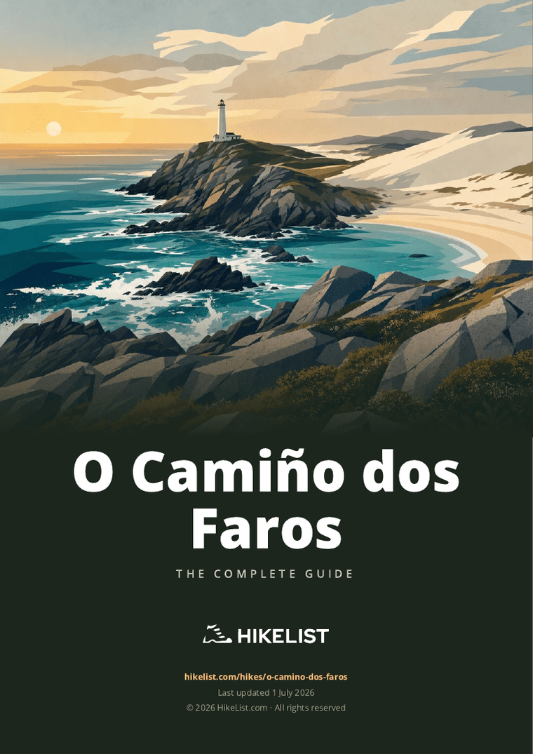
O Camiño dos Faros
How would you rate O Camiño dos Faros?
Tap a star to share your experience and help other hikers.
O Camiño dos Faros: Galicia’s Wild Lighthouse Way
HikeList Score
O Camiño dos Faros scored 86/100 on HikeList's trail-quality metrics.
See score breakdownHide breakdown
- Ideal length 98
- Balanced challenge 84
- Scenery & wildness 74
- Varied terrain 100
- Accommodation 83
- Food & support 81
- Path quality 84
- Season flexibility 89
Computed from length, challenge, scenery & wildness, terrain variety, accommodation, food & support, path quality and season flexibility.
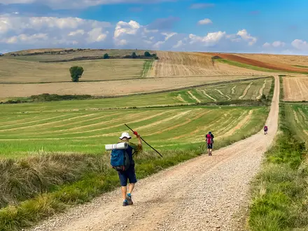
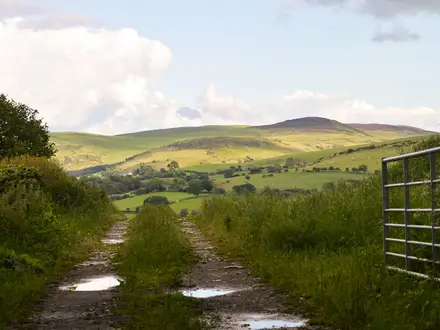
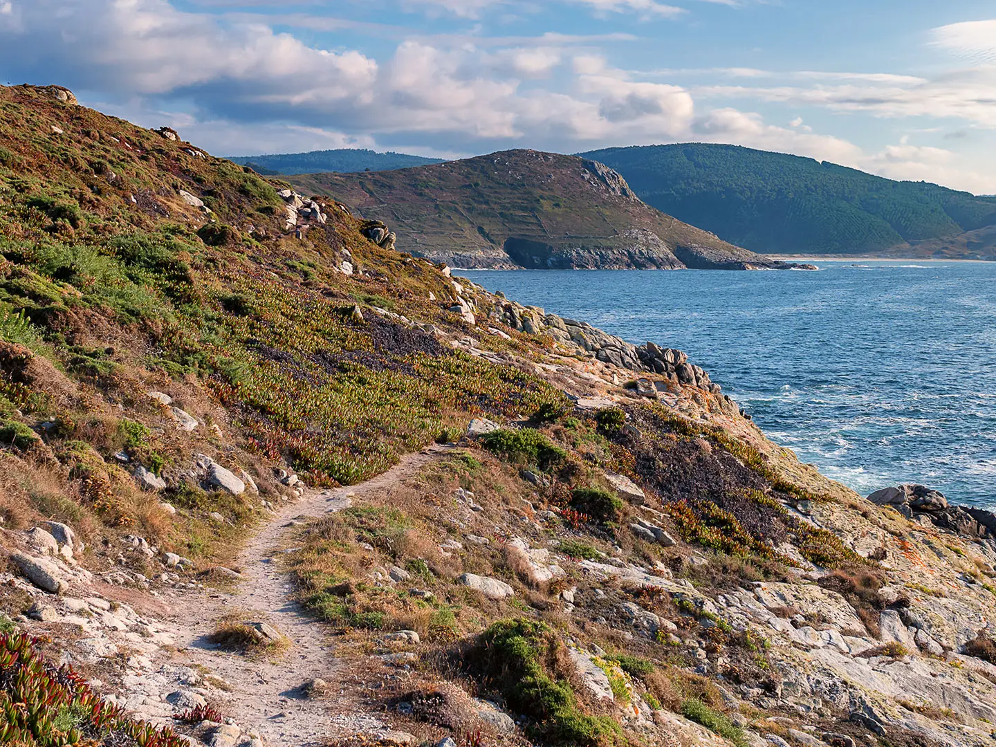
O Camiño dos Faros is a 200 km, 8-day point-to-point coastal trek on the Costa da Morte in Galicia, north-western Spain. Also called The Lighthouse Way, it runs from Malpica de Bergantiños to Cape Finisterre and is hard: expect long stages, steep clifftop climbs and descents, rocky paths, sand and exposed Atlantic weather. It suits experienced hikers who want a rugged sea-level alternative to pilgrimage routes such as the Camino Francés or Camino del Norte.
Route Overview
The route starts in Malpica de Bergantiños and follows the Costa da Morte west and south to Cape Finisterre (Cabo Fisterra). It is divided into 8 official stages: Malpica–Niñóns, Niñóns–Ponteceso, Ponteceso–Laxe, Laxe–Arou, Arou–Camariñas, Camariñas–Muxía, Muxía–Nemiña and Nemiña–Cape Finisterre. Key places include Punta Nariga, Cabo Vilán, Muxía, Lires and the Finisterre lighthouse. This is a point-to-point walk, so plan travel to Malpica and onward from Cape Finisterre; no specific transport services are verified in the brief. For another Spanish coastal trail, compare the Camí de Ronda.
History of O Camiño dos Faros
O Camiño dos Faros is a modern hiking route, created from December 2012 by Galician hikers known as the Trasnos. Their aim was to link the lighthouses and landmarks of the Costa da Morte on foot. The non-profit Asociación Camiño dos Faros has since waymarked and promoted the full 200 km trail. It is not an ancient Camino de Santiago route and has no compostela-style certificate, though it finishes at Cape Finisterre, the symbolic “end of the earth” reached by pilgrims who walk on from Santiago after routes such as the Camino Primitivo.
Notable highlights
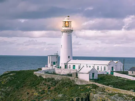
- Cabo Vilán Lighthouse: A dramatic lighthouse on a 100 m granite promontory near Camariñas. Inaugurated in 1896, it was Spain’s first electrically powered lighthouse and now has a visitor centre and café.
- Cemiterio dos Ingleses: A lonely clifftop cemetery near Camariñas for sailors from HMS Serpent, wrecked here in 1890. The disaster helped hasten construction of the Cabo Vilán lighthouse.
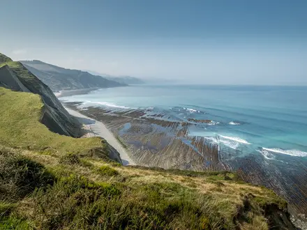
- Praia de Trece and the Reira dunes: A wild, undeveloped beach backed by shifting dunes between Arou and Camariñas. It is one of the most photographed wild stretches of the Costa da Morte.
- Faro de Punta Nariga: A modern lighthouse on Stage 1, designed by Galician architect César Portela to resemble a ship’s prow cutting into the Atlantic.
- Muxía and the Santuario da Virxe da Barca: A fishing town and pilgrimage site where the seaside sanctuary stands among huge granite boulders. It is also a traditional Camino endpoint.
- Cape Finisterre (Cabo Fisterra): The route’s finish at the so-called “end of the earth”, a cape and lighthouse long treated as a symbolic western edge of the known world.
Challenges to expect
This is strenuous coastal trekking rather than an easy beach walk. Daily distances average about 25 km, with the longest stage at 32.6 km. The route repeatedly climbs and descends headlands, with rocky boulder sections, sand, narrow clifftop paths and exposed granite. Green waymarks can blend into vegetation, so carry an offline map or GPX. Weather in Galicia is wet and changeable year-round, and exposed cliffs are hazardous in storms.
HikeList Score
O Camiño dos Faros scored 86/100 on HikeList's trail-quality metrics.
See score breakdownHide breakdown
- Ideal length 98
- Balanced challenge 84
- Scenery & wildness 74
- Varied terrain 100
- Accommodation 83
- Food & support 81
- Path quality 84
- Season flexibility 89
Computed from length, challenge, scenery & wildness, terrain variety, accommodation, food & support, path quality and season flexibility.
Show more data Show less
- Coastal
- Cliffs
- Beaches
- Forest
- Estuaries
- Dirt
- Sand
- Rocky
- Paved
- Hotels
- Guesthouses
- Rural Apartments
- Pet Friendly
- Restrooms
- Water Sources
- Campsites
Download Our Full Guide to O Camiño dos Faros FREE!
Get our comprehensive guide to this hike for free. Save it for later reading or print out at home.
Articles related to this hike
Photos from hikers
Taken on the trail by people who've reviewed O Camiño dos Faros.
O Camiño dos Faros: The Complete Guide
 i
Image by btPhot
i
Image by btPhot O Camiño dos Faros (The Lighthouse Way) is a hard, sea-level traverse of Galicia’s Costa da Morte, linking Malpica de Bergantiños with the lighthouse at Cabo Fisterra (Cape Finisterre). It suits fit, experienced hikers who want wild Atlantic walking rather than a conventional Camino de Santiago route.
The trail stays close to the coast for around 200 km, passing fishing towns, rías, beaches, dunes, granite headlands and exposed clifftops. Bright-green dots, arrows and “Traski” footprints guide the way, but they are subtle enough that an offline GPX and proper map backup are sensible.
Its best sections are rugged and memorable: Faro de Punta Nariga, Praia de Trece, Monte Branco, Cabo Vilán, Muxía and the final approach to Cabo Fisterra all give the route a strong sense of place. The walking is not technically alpine, but the repeated climbs, rock, sand, boulder sections and long daily stages make it demanding.
Plan this as a serious point-to-point hike, not a casual coastal stroll. Accommodation spacing is uneven, public transport needs organising at both ends, and Atlantic weather can make exposed cliffs hazardous.
This guide covers stages, day planning, accommodation, food, transport, terrain and the common mistakes to avoid.
Stage-by-Stage Guide
The official itinerary divides O Camiño dos Faros (The Lighthouse Way) into eight long coastal stages. Treat the distances as full hiking days rather than promenade walks: even the shorter stages include rough ground, beach sand, headlands and waymarking that can be easy to miss in vegetation.
Carry an offline GPX for every stage, plus enough food and water to be independent between settlements. Services vary sharply along the Costa da Morte, and opening hours in small villages should be checked before travelling.
Stage 1: Malpica de Bergantiños to Niñóns — 21.3 km
The route starts in the fishing town of Malpica de Bergantiños and heads west out of the harbour onto the rugged Atlantic coast. This first day sets the pattern for the whole walk: clifftop paths, granite headlands, small coastal settlements, exposed viewpoints and sections where progress is slower than the distance suggests.
The main landmark is Faro de Punta Nariga, a striking modern lighthouse designed by César Portela and shaped like a ship’s prow. It makes a natural rest stop, with wide Atlantic views and outlooks towards the Illas Sisargas.
Expect a mix of dirt path, rock, narrow coastal trail and some paved village or road sections around places such as Barizo. The walking is not technically alpine, but the surface is uneven and can be slippery when wet.
Food and water are easiest to organise at the start in Malpica de Bergantiños. Do not assume frequent services once away from the town; carry enough for the full stage unless current opening hours have been checked.
Niñóns is a small end point compared with the larger towns on the route. Accommodation availability should be checked and booked ahead, and some walkers may need to arrange a transfer or stay nearby depending on what is open.
There is road access at both ends, but no railway. Public transport for intermediate points on this route is limited and should be checked before travelling, especially if planning to skip or shorten this stage.
Navigation is by bright-green dots, arrows and “Traski” footprints. These can blend into vegetation and rock, so keep checking the line against an offline map rather than waiting until the next waymark disappears.
Avoid the exposed clifftop sections in Atlantic storms or poor visibility. Strong wind and wet rock are the main hazards on this stage.
Stage 2: Niñóns to Ponteceso — 27.1 km
Stage 2 is a longer day that continues through remote Costa da Morte terrain before finishing inland at Ponteceso. It is one of the stages where the cumulative nature of the route becomes clear: the distance is substantial, and repeated small climbs and descents over coastal ground add effort.
The path uses a mixture of coastal tracks, narrow paths, sandy sections and rougher rocky ground. Progress can be slow where the route leaves easier tracks for headlands or uneven shoreline terrain.
This stage passes through a quieter stretch of the route, with Corme lying near the line before the approach to Ponteceso. The character shifts towards estuary and settlement as the route closes in on the stage finish.
Food and water should be planned conservatively. Start the day carrying what is needed from Niñóns unless reliable services have been checked, and do not rely on finding frequent resupply points on the wilder parts of the stage.
Ponteceso is a more practical overnight halt than Niñóns, with a better chance of small hotels, guesthouses or apartments. Book ahead, particularly in the main walking season.
Road access is available at Ponteceso, but onward public transport details and operating days should be checked before travelling. This is also a sensible place to reassess the next stage if weather is deteriorating.
Navigation requires attention around transitions between coast, paths, tracks and settlement. Green waymarks are useful but not enough on their own; use GPX to avoid losing time at junctions or overgrown sections.
The main warnings are exposure, slippery rock, mud after rain and fatigue from the length of the day. Start early enough to avoid finishing in poor light.
Stage 3: Ponteceso to Laxe — 25.3 km
Stage 3 links Ponteceso with the coastal town of Laxe and combines estuary-side walking, coastal terrain and village sections. It is another full-length day, so resist judging it only by the moderate-looking profile of a sea-level route.
Underfoot, expect the usual mix for O Camiño dos Faros: dirt path, sand, rock, paved sections and occasional road or village walking. The walking can alternate quickly between easy surfaces and rougher, slower ground.
Corme is associated with this section of the route, and the day gradually returns to the open coast before reaching Laxe. Views are typically across rías, beaches and granite headlands rather than high mountains.
Ponteceso is the best place to stock up before setting out. Food and water availability between Ponteceso and Laxe should not be assumed without checking current local services.
Laxe is one of the main coastal towns on the route and is a logical overnight stop with a wider accommodation base than the smaller villages. Book in advance, especially if following the official eight-day schedule.
Laxe also gives useful road access for joining or leaving the route, though public transport should still be checked before travelling. There is no railhead on the trail itself.
Navigation is generally straightforward where the route follows obvious coast or settlement edges, but the green marks still require concentration at junctions and in vegetation. Keep the GPX active rather than navigating only from memory.
Wet weather can make rocks, wooden surfaces and compacted dirt slippery. In strong Atlantic winds, avoid lingering close to cliff edges even where the path appears clear.
Stage 4: Laxe to Arou — 18 km
Stage 4 is the shortest official stage, but it should not be dismissed as an easy rest day. The terrain remains coastal, uneven and exposed, and the shorter distance is useful recovery before the rougher and longer days that follow.
The route leaves Laxe and continues along the Costa da Morte towards Camelle and Arou. Expect a varied day of beaches, headlands, small settlements and sections of woodland or coastal path.
Underfoot conditions can include sand, dirt path, rock and short paved stretches. Sand and rough rock can make the stage slower than a standard 18 km road or track walk.
Camelle is the main named place between the stage ends, while Arou is the overnight target. Use Laxe to buy supplies before leaving, as services on this stretch should be checked rather than assumed.
Accommodation in Arou and nearby villages can be limited compared with larger towns such as Laxe, Camariñas or Muxía. Reserve ahead and consider transfer logistics if nothing suitable is available at the stage end.
Road access exists through the coastal settlements, but bus options and timings should be checked before travelling. This is not a route where it is safe to rely on frequent turn-up-and-go public transport.
Navigation can be trickier where paths leave the coast briefly, cross settlement edges or run through vegetation. Follow the green waymarks, but use an offline GPX as the primary safeguard.
This is a good stage to protect feet and manage effort: sand, wet grass, mud and rock can all contribute to blisters or slips. In poor weather, exposed headlands may feel much harder than the distance suggests.
Stage 5: Arou to Camariñas — 23.8 km
Stage 5 is one of the signature days of O Camiño dos Faros. It includes Praia de Trece, Monte Branco, the Cemiterio dos Ingleses (English Cemetery) and Faro de Cabo Vilán before finishing in Camariñas.
Praia de Trece is a wild, undeveloped beach of about 1.5 km, broken by rocky outcrops into smaller coves. Above it rises Monte Branco, the immense pale sand dune that gives one of the route’s most memorable viewpoints over the beach, Punta do Boi and the surrounding coast.
The Cemiterio dos Ingleses is a stark clifftop cemetery linked to the wreck of HMS Serpent in 1890, when 172 of 175 crew were lost. The disaster helped define the Costa da Morte’s maritime reputation and contributed to the importance of the later Cabo Vilán lighthouse.
Faro de Cabo Vilán stands on a dramatic granite promontory near Camariñas and was inaugurated in 1896 as Spain’s first electrically powered lighthouse. It is one of the clearest examples on the route of why this coast needed powerful lights.
Terrain is varied and demanding: beach sand, dune paths, granite, narrow coastal trail and exposed headlands. Do not underestimate the effort required to cross sand and climb dune-backed ground with a pack.
Carry food and water from Arou unless current services have been checked. The landmark-heavy middle of the stage is wild, and walkers should plan for a self-sufficient day until Camariñas.
Camariñas is a key overnight halt with a better accommodation base than the smaller villages. It is also a sensible place for resupply before the longest stage of the route.
Road access improves around Camariñas and Cabo Vilán, but public transport and any transfer arrangements should be checked before travelling. Do not rely on being able to leave the route easily from the wilder middle of the day.
Navigation matters around beaches, dunes and headland paths, where footprints and informal lines can be confusing. Stay on the waymarked route and use GPX to avoid trampling sensitive dune areas or drifting onto unsafe ground.
Avoid this stage in storm conditions. The exposed cliffs, rocky promontories and wave-battered coastline are central to the route’s appeal but become serious hazards in bad weather.
Stage 6: Camariñas to Muxía — 32.6 km
Stage 6 is the longest official stage and one of the hardest planning days on the route. At 32.6 km, it demands an early start, disciplined pacing and enough daylight to handle the final kilometres without rushing navigation.
The stage continues through rugged Atlantic coastal terrain, with repeated changes between paths, beaches, rock, woodland, village sections and road or paved stretches. The challenge is less a single climb than the accumulated distance over uneven ground.
The destination, Muxía, is one of the major places on the route and a traditional Camino endpoint. Its seafront setting, Santuario da Virxe da Barca, granite boulders and the nearby “A Ferida” sculpture make it a significant finish to a long day.
Food and water should be planned from Camariñas with the full distance in mind. Any intermediate services should be treated as a bonus unless opening times have been checked before departure.
Muxía has a stronger accommodation base than the smaller stage ends, with small hotels, guesthouses and apartments. Even so, book ahead: arriving after a 32.6 km day without a room is poor planning.
Road access at Camariñas and Muxía makes this one of the more practical stages for arranging a taxi or transfer if needed. Bus options and timetables should still be checked before travelling.
Navigation fatigue is a real issue on this stage. Waymarks can be missed late in the day, especially in vegetation, poor weather or low light, so keep the GPX visible and avoid pushing on after dark.
The main warning is simply the length combined with exposure. Carry a headtorch, waterproofs and enough layers even in the main season, and be ready to shorten or rearrange the day if Atlantic weather turns severe.
Stage 7: Muxía to Nemiña — 25.3 km
Stage 7 leaves Muxía after the sanctuary and granite-boulder coastline and continues south-west through another exposed section of the Costa da Morte. It is shorter than the previous day but still a full mountain-walking-style effort in coastal terrain.
The route passes through or near Lires before reaching Nemiña. The walking mixes open coastal paths, beaches or sandy ground, tracks, woodland and village sections.
Muxía is the place to organise supplies before setting out. Food and water availability between Muxía, Lires and Nemiña should be checked before travelling, particularly outside the busiest season.
Nemiña is a smaller overnight stop, so accommodation needs careful advance planning. If no suitable lodging is available at the stage end, arrange a transfer rather than assuming there will be last-minute options.
Road access is possible at the settlements, but public transport is limited enough that independent walkers should verify current bus or taxi options before committing to a plan. This is especially important for section-hikers joining or leaving here.
Navigation remains coastal and waymarked, but the green marks can be subtle. Use offline mapping through village exits, track junctions and any vegetated sections where paint marks may be hard to spot.
After rain, expect mud, wet vegetation and slippery rock. In strong wind or poor visibility, treat exposed headlands cautiously and keep well back from cliff edges.
Stage 8: Nemiña to Cabo Fisterra (Cape Finisterre) — 26.9 km
The final stage runs from Nemiña to Cabo Fisterra (Cape Finisterre), finishing at the Faro de Fisterra lighthouse. It is a long last day and should be planned as a serious hike, not just a ceremonial walk to the “end of the earth”.
The terrain remains true to the route: Atlantic coast, headlands, beaches, rock, dirt paths, some paved sections and repeated small climbs and descents. Tired legs from the previous week make the final 26.9 km more demanding than the number alone suggests.
The finish at Cabo Fisterra is one of Galicia’s most symbolic coastal endpoints, long treated as the western edge of the known world and used by many pilgrims walking beyond Santiago. O Camiño dos Faros is not an official Camino de Santiago route and does not award a compostela, but the lighthouse finish is still a powerful endpoint.
Carry food and water from Nemiña unless current services have been checked. Fisterra has more facilities than the smaller villages, but the day should not depend on uncertain resupply before reaching the town or cape.
Accommodation is available in and around Fisterra, with small hotels, guesthouses and apartments. Book ahead in the main season, particularly if planning to stay after reaching the lighthouse rather than travel onward the same day.
Fisterra is the main exit point for the route, with direct buses to Santiago de Compostela and onward train or bus connections from there. Current Monbus or Arriva timetables should be verified before travelling.
Navigation into the final cape still deserves care. Do not relax too early: the waymarks can be missed, and the approach to a famous endpoint often brings more paths, roads and people than the quieter stages.
The final warning is weather exposure. Cabo Fisterra is an Atlantic headland, and wind, rain or poor visibility can make the finish bleak and hazardous; avoid clifftop edges in storms and allow enough daylight to reach the lighthouse safely.
Recommended Itinerary
Standard 8-day itinerary
O Camiño dos Faros (The Lighthouse Way) is designed around eight official stages. This is the cleanest itinerary to book because it follows the established stage breaks, but it still means repeated 8–9 hour walking days, exposed clifftop terrain and several accommodation-critical overnight stops.
| Day | From | To | Approx. distance | Why this stage makes sense | Services/accommodation notes |
|---|---|---|---|---|---|
| 1 | Malpica de Bergantiños | Niñóns | 21.3 km | A demanding but manageable opening day, leaving the harbour at Malpica and committing quickly to the rugged Atlantic coast. It includes the Faro de Punta Nariga area before finishing at Niñóns. | Malpica is the practical start point for pre-walk accommodation and supplies. Niñóns is a small stage end, so accommodation or a transfer should be arranged before starting. |
| 2 | Niñóns | Ponteceso | 27.1 km | One of the longer early stages, continuing along headlands and coastal paths before reaching a more useful overnight base at Ponteceso. | Ponteceso is one of the more practical overnight towns on the route. Do not assume last-minute beds at smaller places before it. |
| 3 | Ponteceso | Laxe | 25.3 km | A full day that keeps the route moving west through the Costa da Morte without creating an oversized following stage. | Laxe is a coastal town with better accommodation prospects than the smaller intermediate villages. Book ahead in summer. |
| 4 | Laxe | Arou | 18.0 km | The shortest official stage and a useful partial recovery day after three long starts. It also positions you for the wilder Arou–Camariñas stage. | Arou is a smaller overnight stop than Laxe or Camariñas. Accommodation should be secured in advance, or a transfer plan made. |
| 5 | Arou | Camariñas | 23.8 km | A key scenic stage, taking in the Praia de Trece and Monte Branco area before the Cabo Vilán approach and Camariñas. The distance is moderate on paper but the terrain and exposure make it a serious day. | Camariñas is an important service town and a logical place to recover, resupply and dry kit if the weather has been poor. |
| 6 | Camariñas | Muxía | 32.6 km | The longest official stage. It is the day most likely to affect the whole schedule, so start early and treat it as a major undertaking rather than a normal coastal walk. | Muxía has the advantage of being a recognised coastal town and traditional Camino endpoint, with better accommodation prospects than small villages. If this stage is too long, use the slower variant below. |
| 7 | Muxía | Nemiña | 25.3 km | A long but logical penultimate stage, leaving Muxía and working towards the final approach to Cabo Fisterra. | Nemiña is a smaller stage end, so this night should be booked early. If accommodation is unavailable, check local transfer options before committing to the itinerary. |
| 8 | Nemiña | Cabo Fisterra (Cape Finisterre) | 26.9 km | A final full stage to the Faro de Fisterra, giving the route a clear finish at the cape rather than ending in town early. | Fisterra is the practical post-walk base. Plan onward bus travel from Fisterra to Santiago de Compostela and verify current timetables before travelling. |
Slower variant: 9–10+ days
A slower schedule suits walkers who want more margin for weather, photography, shorter walking days or recovery after the longest stages. It is also the better choice for anyone carrying full luggage, walking outside the most settled summer period, or unsure about repeated 25 km coastal days.
The most useful places to reduce pressure are:
- Stage 6: Camariñas to Muxía, 32.6 km — the obvious stage to split if accommodation and transport allow.
- Stage 2: Niñóns to Ponteceso, 27.1 km — a long early day before the body has settled into the route.
- Stage 8: Nemiña to Cabo Fisterra, 26.9 km — consider breaking the final approach if you want time at Cabo Fisterra rather than arriving late and tired.
Any slower itinerary depends heavily on beds in smaller coastal places and villages such as Camelle, Arou, Lires or other intermediate stops. Do not build a slower plan from the map alone: check official mapping, accommodation availability and any required transfers before booking.
Faster variant: 7 days or fewer
A faster itinerary is only sensible for very fit, experienced hikers travelling light and comfortable with long exposed days on rocky, sandy and sometimes poorly marked terrain. The official 8-day plan already averages around 25 km per day and includes a 32.6 km stage, so compressing the route usually means either combining parts of stages or using transfers.
For most independent walkers, a faster schedule is not recommended. If time is limited, it is usually better to walk a selected section properly than to force the full route into too few days. Exact faster-stage distances and overnight points should be checked against official mapping before booking.
Planning the Route
O Camiño dos Faros is best planned around its overnight stops, not around arbitrary mileage. The official itinerary uses eight long stages, and those stages largely reflect where accommodation and services exist along this rugged section of the Costa da Morte.
For strong, experienced walkers, the eight-stage schedule is the cleanest plan. It keeps the route simple, follows the established Malpica de Bergantiños to Cabo Fisterra (Cape Finisterre) structure, and avoids needing extra transfers between small coastal places.
Many hikers will be more comfortable allowing extra time. The route’s difficulty comes less from altitude and more from repeated headland climbs, rough rock, sand, boulder sections, exposed clifftops and long days where progress can be slower than the map suggests.
How many days to allow
The official plan is eight walking days, with stages commonly taking a full day on foot. This is a demanding schedule: several days are around 25 km or more, and the Camariñas to Muxía stage is the longest at 32.6 km.
A slower plan is sensible if you want margin for bad weather, photography, swimming stops, lighthouse visits or simply less pressure on rough ground. Adding one or more extra nights can make the route feel far less rushed, but it requires more careful accommodation and transport planning because not every coastal settlement has the same level of services.
A rest or short day is easiest to justify in the larger overnight towns, especially Laxe, Camariñas, Muxía or Fisterra, where there is more chance of accommodation and basic services. This should be checked before travelling.
Using the official stages
The official stages are the natural planning framework because they connect recognised overnight points. They are not short Camino-style days; most require an early start and a realistic view of pace on sand, rock and exposed coastal paths.
| Planning point | What it means on this route |
|---|---|
| Official schedule | 8 stages from Malpica de Bergantiños to Cabo Fisterra |
| Average day | Long, typically a full day of walking rather than a half-day ramble |
| Longest day | Camariñas to Muxía, 32.6 km |
| Shortest official day | Laxe to Arou, 18 km |
| Best use of extra time | Splitting long stages, adding weather margin, or taking a rest day in a larger town |
Do not assume that a shorter stage automatically makes for an easy day. Coastal terrain, detours around headlands, sand underfoot and poor weather can all slow progress.
Accommodation planning
Book accommodation before starting, especially if walking in summer or during local holiday periods. The route passes through small fishing towns and villages rather than a continuous chain of large resort centres, so availability can be uneven.
The main overnight bases on the standard route include Malpica de Bergantiños, Ponteceso, Laxe, Camariñas, Muxía and Fisterra, with smaller stage-end settlements such as Niñóns, Arou and Nemiña requiring more care. If an intended stop has little or no suitable accommodation for the chosen date, plan a transfer rather than arriving without a fall-back.
Wild camping is prohibited in the protected coastal areas, so the route should not be planned as a camp-anywhere walk. If using rural apartments, guesthouses or small hotels, check arrival times, food availability and whether luggage transfer or local taxi help is needed before booking.
Food and water
Food planning matters more on the wilder middle sections than in the larger towns. Do not rely on finding open cafés, shops or bars at every beach, lighthouse or headland.
Carry enough food for the walking day, particularly between smaller overnight stops. Water should be topped up whenever reliable opportunities appear in towns or villages, and daily refill options should be checked locally before setting off.
A practical daily routine is to buy breakfast supplies, lunch and emergency snacks the evening before where possible. This avoids losing time in the morning and reduces the risk of starting a long coastal stage with too little food.
Navigation and route-finding
The route is waymarked with bright-green dots, arrows and “Traski” footprints, but the markings can blend into vegetation and should not be the only navigation method. O Camiño dos Faros is not a GR route or National Trail, and it is not signed like the main Camino de Santiago routes.
Carry an offline GPX track and an offline map on a phone or GPS device, with enough battery for a long day. A paper or backup navigation option is sensible because several stages pass through exposed, rough and relatively remote coastal terrain.
The route was created and waymarked by the Asociación Camiño dos Faros / Trasnos, but formal maintenance and official recognition have changed over time. Current waymarking, diversions and access issues should be checked before travelling.
Weather and timing
Late spring, summer and early autumn are the normal planning window. Galicia can still be wet and changeable in these months, so waterproofs, warm layers and flexible timing remain important.
Atlantic storms are the main weather hazard. Exposed clifftop paths, granite headlands and boulder sections should be avoided in severe wind, heavy rain or poor visibility.
Build in enough time to wait out bad conditions if possible. A rigid eight-day plan with pre-booked accommodation every night leaves little room for weather delays, so strong walkers on a fixed schedule should still know where exits, roads and accommodation alternatives are possible. This should be checked before travelling.
Transport and section hiking
This is a point-to-point route with no railway station at either end, so transport needs to be planned before accommodation is fixed. Malpica de Bergantiños is normally reached by bus via Carballo from A Coruña, or from Santiago de Compostela via city and onward bus connections; private transfers also operate.
At the finish, Fisterra has direct bus links to Santiago de Compostela for onward train or bus travel. Current Monbus and Arriva timetables should be checked before travelling, especially for weekends, holidays and early or late departures.
Section hiking is possible, but it is less straightforward than on a rail-served trail. The most practical approach is to base sections around the larger towns, use local buses where they fit, and budget for taxis or private transfers where public transport does not match the walking plan.
Permits and route status
O Camiño dos Faros is not an official Camino de Santiago pilgrimage route, and it does not provide a compostela certificate. Plan it as an independent coastal trek rather than a pilgrim-infrastructure route.
The main access issue to plan around is accommodation and camping, not permits. Wild camping is prohibited in protected coastal areas, and any local restrictions, diversions or temporary closures should be checked before travelling.
Towns, Villages and Overnight Stops
O Camiño dos Faros (The Lighthouse Way) is best planned around its official stage ends: Malpica de Bergantiños, Niñóns, Ponteceso, Laxe, Arou, Camariñas, Muxía, Nemiña and Fisterra / Cabo Fisterra (Cape Finisterre). The larger coastal towns give the most reliable choice of small hotels, pensións, apartments, food and shops; the smaller villages need more care, especially Niñóns, Arou and Nemiña.
Book accommodation before starting, particularly if walking the eight-stage itinerary exactly. Wild camping is prohibited in the protected coastal areas, and the wild middle stages leave little room for improvising late in the day.
| Official stage end | Planning role | Practical note |
|---|---|---|
| Malpica de Bergantiños | Start town | Main pre-walk overnight option before Stage 1 |
| Niñóns | Stage 1 end | Small, exposed overnight point; check accommodation and food before committing |
| Ponteceso | Stage 2 end | One of the more practical resupply and overnight stops |
| Laxe | Stage 3 end | Coastal town with a stronger overnight role |
| Arou | Stage 4 end | Smaller village stop; book ahead |
| Camariñas | Stage 5 end | Key coastal town before the longest official stage |
| Muxía | Stage 6 end | Major walker stop and traditional Camino endpoint |
| Nemiña | Stage 7 end | Small final-stage staging point; check services carefully |
| Fisterra / Cabo Fisterra | Finish area | Finish logistics are centred on Fisterra, with the route ending at Faro de Fisterra |
Malpica de Bergantiños
Malpica de Bergantiños is the start of the route, with the green waymarks leading west out of the fishing town and harbour. It is the logical place to arrive the day before walking, especially if travelling in from A Coruña or Santiago de Compostela via Carballo.
As one of the main coastal towns on the route, Malpica is a practical overnight base with small hotels, guesthouses and apartments. It is also the last place to organise anything forgotten before the route immediately becomes more rugged and exposed.
Food and basic supplies should be sorted here before Stage 1. Do not rely on being able to solve logistics later in the day at headlands or small settlements.
Transport is by bus rather than rail. Current bus times via Carballo from A Coruña or Santiago de Compostela should be checked before travelling.
Barizo
Barizo comes early on Stage 1 between Malpica de Bergantiños and Punta Nariga. It is useful as a route marker and possible pause, but it is not one of the official stage-end overnight stops.
Treat Barizo as a small settlement on a long coastal stage rather than as a guaranteed logistics base. Accommodation, food and onward transport options should be checked before building an itinerary around it.
Punta Nariga
Punta Nariga is a headland and lighthouse point on Stage 1, not a village overnight stop. It is one of the key landmarks between Malpica de Bergantiños and Niñóns, and a natural rest point if weather allows.
There should be no assumption of accommodation, shops or regular onward transport at the lighthouse. Carry food and water for the stage and be ready to move on if the headland is windy or exposed.
Niñóns
Niñóns is the official end of Stage 1 from Malpica de Bergantiños and the start of Stage 2 to Ponteceso. Its position makes it important, but it is a smaller and less forgiving stop than the larger towns later on the route.
Accommodation and evening food should be arranged before starting the walk. This is one of the places where the route’s uneven service spacing matters most: arriving tired after a long coastal day without a booking is a poor plan.
Public transport and taxi options should also be checked before travelling if Niñóns is being used as a start, finish or bailout point. Do not assume the same level of service as in Malpica, Ponteceso, Laxe, Camariñas, Muxía or Fisterra.
Ponteceso
Ponteceso is the official end of Stage 2 from Niñóns and the start of Stage 3 to Laxe. It is one of the more useful logistical stops on the trail and a sensible place to reset after two demanding coastal days.
As a coastal town on the route, Ponteceso has a better overnight role than the smaller village stops, with small hotels, pensións and apartments forming the typical accommodation mix. Book ahead, but this is one of the more practical places to plan food, rest and resupply.
Stage 3 is another full day, so walkers should leave Ponteceso with enough food and water rather than relying on services appearing at exactly the right point. Any bus or taxi plans from Ponteceso should be checked locally before travelling.
Corme
Corme sits near the route between Ponteceso and Laxe rather than being an official stage end in the standard eight-day itinerary. It may be relevant for walkers adapting Stage 3, but it should not be treated as a default overnight unless accommodation and onward logistics are arranged.
Its main planning value is flexibility: it can help break up the section if the official stages feel too long. Check accommodation, food and transport before committing to a revised schedule.
Laxe
Laxe is the official end of Stage 3 from Ponteceso and the start of Stage 4 to Arou. It is one of the stronger overnight stops on O Camiño dos Faros, with the practical advantage of being a coastal town rather than a small hamlet.
Expect the usual mix of small hotels, guesthouses and apartments rather than large walker infrastructure. Book early in busy periods, and use the town to restock before the quieter sections ahead.
Stage 4 to Arou is the shortest official stage, but it still crosses rugged Costa da Morte terrain. Laxe is therefore a good place to deal with blisters, wet kit and food supplies before moving into smaller overnight points.
Camelle
Camelle lies on Stage 4 between Laxe and Arou. It is useful as an intermediate settlement on a shorter official day, but it is not the standard stage end.
Walkers splitting stages may consider it when designing a more relaxed itinerary, but accommodation and food should be checked before booking around it. Do not assume that every coastal village has the same range of services as Laxe or Camariñas.
Arou
Arou is the official end of Stage 4 from Laxe and the start of Stage 5 to Camariñas. It is a small village stop and should be planned carefully.
Accommodation may be limited compared with the larger towns, so secure a bed before starting the route if following the official schedule. Evening food and next-day supplies should also be checked in advance.
Arou is an important staging point because Stage 5 includes some of the route’s wildest and most memorable ground, including Praia de Trece, Monte Branco, the English Cemetery and Cabo Vilán before reaching Camariñas. Start the day with enough food and water for exposed coastal walking.
Praia de Trece / Monte Branco
Praia de Trece and Monte Branco are major Stage 5 landmarks, not overnight bases. This is a wild coastal section between Arou and Camariñas, and walkers should treat it as remote terrain for planning purposes.
There should be no assumption of shops, cafés, accommodation or transport at Praia de Trece or on Monte Branco. Carry what is needed from Arou and keep enough time in hand for the continuation to Camariñas.
Cabo Vilán
Cabo Vilán is a lighthouse headland near Camariñas and one of the most important landmarks on Stage 5. It has a visitor-centre role at the lighthouse, but it is not the main overnight logistics point.
Use Camariñas for accommodation planning rather than relying on the headland. Weather can be severe on this exposed granite promontory, so avoid arriving late or tired with unresolved onward plans.
Camariñas
Camariñas is the official end of Stage 5 from Arou and the start of Stage 6 to Muxía. It is a key overnight stop because the following day is the longest official stage of the route.
As one of the main coastal towns, Camariñas is a stronger place for small hotels, pensións, apartments, food and basic supplies. It is a sensible point to check the next day’s weather, charge devices, review the GPX and decide whether to keep the official schedule or split the next section.
Stage 6 to Muxía is 32.6 km, so Camariñas is not a place to leave late or under-supplied. Anyone unsure about completing the longest stage should arrange a shorter itinerary before setting out.
Muxía
Muxía is the official end of Stage 6 from Camariñas and the start of Stage 7 to Nemiña. It is one of the most important walker towns on the route and also a traditional Camino endpoint, although O Camiño dos Faros itself is not an official Camino de Santiago route and does not provide a compostela certificate.
Accommodation is generally more practical here than in the smaller villages, with the route’s typical mix of small hotels, guesthouses and apartments. Book ahead, especially because Muxía attracts walkers beyond this trail.
The town is a good place for food, rest and recovery after the longest official stage. The Santuario da Virxe da Barca area and the granite boulders are close to the route, but practical priorities should come first: supplies, laundry or drying kit, and checking conditions for the exposed onward coast.
Lires
Lires lies between Muxía and Nemiña / Fisterra in the final part of the route area. It is relevant for walkers adjusting the last two stages, especially if the official Muxía–Nemiña and Nemiña–Cabo Fisterra days feel too long.
Do not assume availability without booking. Accommodation, food and transport should be checked before using Lires as a planned overnight or section break.
Nemiña
Nemiña is the official end of Stage 7 from Muxía and the start of the final stage to Cabo Fisterra. Like Niñóns and Arou, it needs more careful planning than the larger towns.
Secure accommodation before committing to the standard eight-stage itinerary. Food options and next-day supplies should also be checked in advance, as the final stage is still a long day at 26.9 km.
Nemiña’s main value is positional: it sets up the walk to Cabo Fisterra without making the final day excessively long. It should be treated as a small staging point rather than a full-service trail town.
Fisterra and Cabo Fisterra (Cape Finisterre)
Fisterra is the finish-area town, while the route itself ends at Faro de Fisterra on Cabo Fisterra. Plan accommodation and onward travel around Fisterra rather than treating the lighthouse as a logistics hub.
As one of the main towns on the route, Fisterra has the best role at the end for beds, food and recovery after the final stage. It is also the place to organise onward travel, with direct buses running to Santiago de Compostela and onward train or bus connections from there.
Current bus timetables should be checked before travelling, particularly if planning to leave the same day as finishing. The final walk to the lighthouse is still part of the route, so allow enough time for the cape, the return to town if needed, and the bus connection.
Getting to the Start
By train
There is no railway station at Malpica de Bergantiños, so rail travel only gets you part of the way to the start. The practical rail hub is A Coruña, from where you continue by bus via Carballo or by pre-booked transfer.
Santiago de Compostela is another useful arrival point if it fits your wider travel plans, but it still requires onward bus travel towards Carballo and Malpica. Current rail and onward bus timings should be checked before travelling, especially if arriving late in the day.
By bus
Malpica is reached by bus via Carballo, with connections from A Coruña. This is the main public-transport approach for walkers starting O Camiño dos Faros (The Lighthouse Way).
From Santiago de Compostela, take the airport/city bus connection if arriving by air, then continue by bus towards Carballo and Malpica. The brief public-transport pattern for this route involves Monbus/Arriva services, but timetables, route numbers and connection times change seasonally and should be checked before travelling.
Build in contingency time. Missing the final connection to Malpica can mean paying for a taxi or staying overnight in A Coruña, Santiago de Compostela or Carballo before continuing to the coast.
By car
Driving to Malpica is possible, but it creates the usual problem for a point-to-point hike ending at Cabo Fisterra (Cape Finisterre), not back at the start. Unless someone is collecting the vehicle, you will need a plan to return to Malpica after the walk or arrange a transfer at one end.
Do not assume suitable long-stay parking will be available without checking locally. Ask accommodation in Malpica about parking options before booking, and confirm whether leaving a vehicle for the full duration of the walk is permitted. This should be checked before travelling.
For most walkers, public transport to Malpica and bus travel away from Fisterra is simpler than trying to manage a car at the start.
From the nearest airport
A Coruña is the nearest airport and also the nearest major rail hub for the start. From A Coruña, continue by bus via Carballo to Malpica, or use a private transfer if arriving outside convenient bus times.
Santiago de Compostela is also workable, particularly for international arrivals or walkers combining the trip with travel through the city. From Santiago de Compostela Airport, use bus 6A into the city, then continue by bus towards Carballo and Malpica. Current airport-bus, intercity-bus and connection times should be checked before travelling.
Private transfers operate in the area and can be useful for late arrivals, groups, or walkers who want to start directly in Malpica without a long wait between buses. Confirm the fare, pick-up point and luggage capacity before booking.
Where to stay before starting
Staying in Malpica de Bergantiños the night before the first stage is the most practical option. The route begins in the fishing town, with the green waymarks leading west out of the harbour along the Costa da Morte, so an overnight stay removes the risk of a delayed morning transfer before a long first day to Niñóns.
Accommodation in Malpica is in small hotels, guesthouses and apartments rather than large trail infrastructure. Book ahead in busy periods, and confirm check-in arrangements if arriving by evening bus or transfer.
If connections do not line up, A Coruña, Santiago de Compostela or Carballo can work as pre-start overnight bases, but this leaves an additional journey to Malpica on the morning of Stage 1. That is less ideal, because the first stage is already a full coastal walking day and should not be started late.
Getting Home from the Finish
O Camiño dos Faros finishes at the Faro de Fisterra, on Cabo Fisterra (Cape Finisterre), but onward transport should be planned from Fisterra town rather than from the lighthouse itself. Build in time at the end of the final stage for getting off the cape, collecting luggage if using transfers, and reaching the bus stop or accommodation before evening services thin out.
By train
There is no railway at Cabo Fisterra or Fisterra. The practical rail connection is to take a bus from Fisterra to Santiago de Compostela, then continue by train or long-distance bus from there.
Do not plan a same-day rail connection too tightly after finishing the trail. The final stage from Nemiña to Cabo Fisterra is long, and bus times from Fisterra are timetable-dependent. Current onward rail and bus times from Santiago de Compostela should be checked before booking fixed tickets.
By bus
The main public-transport exit is the direct bus from Fisterra to Santiago de Compostela. From Santiago, onward connections by train or bus can be arranged to other Spanish cities and airports.
Timetables can change by season and day of week, so check current Monbus/Arriva schedules before travelling. This is especially important if finishing late in the day, on a Sunday, or outside the main walking season.
If the last usable bus has gone, staying in Fisterra is usually the simplest option rather than trying to force a late transfer after an already long final stage.
By car/taxi
Private transfers and taxis are useful if you need to reach Santiago de Compostela, A Coruña or a pre-booked hotel on a fixed schedule. They are also the safer fallback if the final day runs late, weather slows progress on the exposed coast, or public-bus times do not line up with onward travel.
Arrange any long-distance taxi or transfer in advance rather than assuming immediate availability at the finish. Prices, pickup points and availability should be checked before travelling.
From the nearest airport
For flights after the hike, the most straightforward plan is to travel from Fisterra to Santiago de Compostela first, then continue to the airport or onward transport hub from there. Airport-transfer details and flight-day bus times should be checked before booking, because the route finish has no rail link and relies on bus or road transfers.
A Coruña is also a relevant transport hub for this route, particularly for access at the start, but finishing logistics from Cabo Fisterra normally revolve around getting back to Santiago de Compostela first.
Where to stay at the finish
Fisterra has small hotels, guesthouses and apartments, making it a sensible place to spend the night after finishing at Cabo Fisterra. This gives a more relaxed margin for the final stage, avoids rushing off the cape to catch a bus, and makes weather or navigation delays less stressful.
Booking ahead is advisable in the main walking season and around busy travel periods. If using luggage transfer or a taxi, make sure the accommodation address and pickup arrangements are clear before setting out on the final day.
Which Direction Should You Walk?
Standard direction: Malpica de Bergantiños to Cabo Fisterra
The route is designed and normally walked from Malpica de Bergantiños to Cabo Fisterra (Cape Finisterre). The official eight-stage structure, stage names and trail narrative all run this way, beginning in the fishing town of Malpica and finishing at the Faro de Fisterra lighthouse.
This is also the strongest direction psychologically. The walk builds towards Cabo Fisterra, the symbolic “end of the earth”, giving the final day a clear destination rather than starting with the route’s natural climax.
Transport also works well in this direction. Malpica is reached by bus via Carballo from A Coruña, or from Santiago de Compostela via the city and onward bus links, while Fisterra has direct bus connections back to Santiago de Compostela. Current Monbus/Arriva timetables should be checked before travelling.
The scenery progression is better in the standard direction too. The route moves west and south through the Costa da Morte, with major later highlights including Praia de Trece, Monte Branco, Cabo Vilán, Muxía and finally Cabo Fisterra. That gives the second half of the walk a strong sense of escalation rather than anticlimax.
Walking it in reverse
Walking from Cabo Fisterra to Malpica is possible in practical terms, but it is less natural for planning. The same towns and villages can be used in reverse, but the route is not generally presented that way, so stage notes, daily expectations and the overall flow are less intuitive.
There is no clear climbing advantage either way. O Camiño dos Faros is a sea-level coastal route with repeated short, steep climbs and descents over headlands rather than one major pass; reversing the route simply turns many awkward descents into climbs and vice versa.
The main caution in reverse is navigation. The route uses bright-green dots, arrows and “Traski” footprints, and these can blend into vegetation. In either direction, but especially when walking against the usual stage order, an offline GPX track and map are essential.
Weather should not be used as a reason to choose reverse. Galicia’s Atlantic coast is wet, changeable and exposed, and storm conditions matter far more than direction. Avoid exposed clifftop sections in severe weather whichever way you walk.
Accommodation and stage flow
The standard direction follows the established overnight sequence: Malpica de Bergantiños, Niñóns, Ponteceso, Laxe, Arou, Camariñas, Muxía, Nemiña and Cabo Fisterra. This makes booking simpler because the official stage distances match the usual end points.
Reverse walkers can use the same places, but accommodation spacing remains uneven, particularly through the wilder middle stages. Book ahead in either direction, especially if trying to split the long official stages into shorter days.
Recommendation
Walk Malpica de Bergantiños to Cabo Fisterra unless there is a specific transport or accommodation reason to do otherwise. It is the standard direction, fits the official stage structure, has a better scenic and psychological finish, and leaves the most memorable endpoint — the lighthouse at Cabo Fisterra — for the final day.
Accommodation Along the Route
O Camiño dos Faros works well as an inn-to-inn walk, but it needs more planning than the busier pilgrimage Caminos. Accommodation is a mix of small hotels, pensións, guesthouses and rural apartments, with the best choice in the larger coastal towns: Malpica de Bergantiños, Ponteceso, Laxe, Camariñas, Muxía and Fisterra.
The weaker points are the smaller stage-end villages, especially Niñóns, Arou and Nemiña. These places are useful for keeping to the official eight-stage itinerary, but choice is limited and walkers should not arrive without a booking.
Wild camping is prohibited in protected coastal areas, so the route should be planned around fixed overnight stops. This is particularly important on the wild middle sections around Praia de Trece, Monte Branco, Cabo Vilán and the long exposed approaches between stage towns.
Best overnight pattern
Most walkers following the official itinerary use these overnight stops:
- Malpica de Bergantiños
- Niñóns
- Ponteceso
- Laxe
- Arou
- Camariñas
- Muxía
- Nemiña
- Fisterra, after finishing at Cabo Fisterra (Cape Finisterre)
This keeps the walking aligned with the eight official stages, but it does not mean every overnight has the same level of services. The longer and more awkward accommodation days need booking first, not last.
If a full stage is too long, taxis or private transfers can help bridge awkward gaps, especially where accommodation is sparse. Arrange these before walking the stage rather than assuming there will be a vehicle available in a small village at the end of the day. This should be checked before travelling.
Accommodation by place
| Place | Accommodation level | Best for | Notes |
|---|---|---|---|
| Malpica de Bergantiños | Good | Start-night accommodation | Fishing town and practical place to stay before Stage 1. Book before arrival if travelling in the main walking season. |
| Niñóns | Limited | Official Stage 1 overnight | A small stage-end village with limited options. This is one of the key bookings to secure early. |
| Ponteceso | Good | Official Stage 2 overnight | One of the stronger service stops on the route and a useful place to reset after the long Niñóns–Ponteceso stage. |
| Laxe | Good | Official Stage 3 overnight | Coastal town with a better choice of small hotels, guesthouses and apartments than the smaller villages. |
| Arou | Limited | Official Stage 4 overnight | Useful for keeping the official Laxe–Arou and Arou–Camariñas stages manageable, but accommodation is limited. Book ahead. |
| Camariñas | Good | Official Stage 5 overnight | One of the main accommodation bases on the route, well placed after the exposed Praia de Trece, Monte Branco and Cabo Vilán section. |
| Muxía | Good | Official Stage 6 overnight | Strong overnight stop and a practical base before the Muxía–Nemiña stage. Also a traditional Camino endpoint, so book ahead in busy periods. |
| Lires | Limited | Possible split or staging point | A useful village on the western end of the route for walkers adjusting the final stages. Availability and logistics should be checked before travelling. |
| Nemiña | Limited | Official Stage 7 overnight | Important overnight for the standard itinerary before the final stage to Cabo Fisterra. Secure accommodation before committing to this stage plan. |
| Fisterra | Good | Finish-night accommodation | Best place to stay after reaching the lighthouse at Cabo Fisterra. The trail finishes at the cape, but most walkers overnight in Fisterra rather than at the lighthouse. |
| Punta Nariga, Praia de Trece, Cabo Vilán, Cabo Fisterra lighthouse | None for route-planning purposes | Daytime landmarks only | Treat these as exposed walking highlights, not overnight bases. Plan accommodation in the nearest suitable town or village. |
Booking strategy
Book the limited villages first: Niñóns, Arou and Nemiña. Once those are secured, arrange the larger towns around them.
In late spring, summer and early autumn, accommodation along the Costa da Morte can fill with walkers and coastal visitors, particularly at weekends. The route is not a high-capacity Camino corridor with frequent albergues, so leaving bookings until the day before can cause problems.
Apartment-style accommodation may be useful for groups, but single walkers should check whether minimum stays apply. Prices, opening periods and cancellation conditions change seasonally, so confirm current details before booking.
Luggage transfer and taxis
The route can be walked with a light daypack if luggage transfer or taxi support is arranged, but services should be organised in advance. The point-to-point nature of the walk, the lack of railheads at either end and the uneven accommodation spacing make ad-hoc logistics unreliable.
Private transfers can also help if a preferred accommodation stop is off the exact stage line, or if the official Camariñas–Muxía stage feels too long. Agree pick-up points clearly, as some sections use beaches, headlands and small coastal lanes rather than obvious town-centre trailheads.
Is it suitable for inn-to-inn walkers?
Yes, provided accommodation is booked ahead and daily distances are treated seriously. O Camiño dos Faros is a good fit for experienced walkers who want guesthouse-to-guesthouse logistics rather than camping.
It is less suitable for hikers who prefer to improvise overnight stops, carry no reservations or rely on a dense network of pilgrim hostels. The accommodation pattern is workable, but it is not forgiving if a limited village is full.
Camping and Wild Camping
O Camiño dos Faros is not a straightforward camping trek. Although it feels remote for long stretches, much of the appeal of the route comes from protected, exposed coastal terrain: cliffs, dunes, beaches, headlands, heath and small fishing settlements. Wild camping is prohibited in the protected coastal areas, and walkers should not plan the route around discreet beach or clifftop camps.
The practical default is to use fixed accommodation in the stage towns and villages, especially Malpica de Bergantiños, Ponteceso, Laxe, Camariñas, Muxía and Fisterra. Anyone wanting to camp should treat legal camping as a separate planning task and identify authorised campsites or permitted pitches before travelling.
Campsites and legal camping
No reliable campsite list is included here for the route. Campsite availability, opening dates and whether a site accepts walkers for a single night can change, especially outside summer. This should be checked before travelling.
If camping, plan each night around a confirmed legal place to sleep rather than assuming there will be an option near the end of every official stage. The route’s official stages are long, and some finish points are small settlements where services may be limited.
A camping itinerary may also need shorter or longer walking days than the standard eight-stage schedule. Do not commit to a full camping load unless the overnight stops have been matched carefully against the route, food resupply and water access.
Wild camping
Do not wild camp in protected coastal areas on the Costa da Morte. This includes the sensitive dunes, beaches, cliff edges and undeveloped headlands that the route passes through, including wild sections around places such as Praia de Trece and Monte Branco.
Camping on private land also requires the landowner’s permission. If a local authority, accommodation owner or campsite operator offers clear guidance, follow that instead of relying on general assumptions about informal camping in Spain.
Bivvying on beaches, behind dunes or beside lighthouses is not a responsible plan for this trail. Apart from legality, the coast is exposed to Atlantic weather, wind and storms, and cliff-top ground can be hazardous in poor visibility or at night.
Does the route suit carrying camping gear?
Only fit, experienced hikers should consider carrying camping equipment on O Camiño dos Faros. The route already has long days, around 4,000 m of total ascent, rocky sections, sand, boulder fields and repeated climbs over headlands. A heavy pack will make the harder stages noticeably tougher.
The Camariñas to Muxía stage is the longest official day at 32.6 km, and several other stages are around 25–27 km. Carrying a tent, stove, sleeping kit and extra water over those distances is a serious undertaking, particularly in heat, wind or wet weather.
For most walkers, a lighter pack and booked accommodation is the better option. Camping is more realistic for those willing to split the route over more days and build the itinerary around confirmed legal sites rather than the official stage ends.
Water, food and resupply
Do not rely on natural water sources along the coast. The route passes beaches, estuaries and exposed headlands, but that does not mean there is safe drinking water available. Carry enough water between settlements and refill at accommodation, cafés, shops or other legitimate sources where available.
Food planning matters if camping because some stretches between larger towns are wild and services are uneven. Malpica de Bergantiños, Ponteceso, Laxe, Camariñas, Muxía and Fisterra are the main practical places to organise supplies, but opening hours and seasonal availability should be checked locally.
Fires, stoves and impact
Open fires are inappropriate on this route and should not be used. The coastal vegetation, dunes and heath are sensitive, and wind can make fire risk unpredictable. Any stove use must comply with local restrictions; this should be checked before travelling, especially in summer.
Follow strict Leave No Trace practice: camp only where legal, avoid dunes and vegetation, pack out all rubbish, never bury waste in sand or near water, and leave beaches, cliffs and headlands exactly as found. Keep well back from cliff edges and avoid pitching anywhere exposed to rockfall, waves or sudden weather changes.
Practical recommendation
For this route, camping should be treated as possible only with careful advance planning, not as the standard approach. The safest and simplest strategy is to book accommodation in the coastal towns and villages, carry an offline GPX, and keep the pack light enough for the long, rugged stages.
Food, Water and Resupply
O Camiño dos Faros is not a serviced Camino-style route. Treat it as a rugged coastal trek where food and water planning is done around overnight stops, not around regular cafés on the trail.
The most reliable resupply points are the larger coastal towns on the route: Malpica de Bergantiños, Ponteceso, Laxe, Camariñas, Muxía and Fisterra. Smaller stage ends and villages such as Niñóns, Arou and Nemiña should be treated as limited-service places unless accommodation has specifically arranged meals or there is a local bar or shop open when you arrive. This should be checked before travelling.
Practical food strategy
Carry lunch and snacks for each full walking day before leaving the stage start. The official stages are long, often 8–9 hours, and several cross exposed headlands, beaches, dunes and lighthouse sections where there may be no practical food stop.
A simple approach is to buy breakfast or picnic food the evening before, then carry enough for the whole next stage. This is particularly important before leaving smaller overnight stops and before the wilder middle stages around Praia de Trece, Monte Branco, Cabo Vilán and the long Camariñas–Muxía stage.
Do not assume that a village shown on the map will have an open shop, café or bar. Rural opening hours can be short, seasonal and affected by Sundays, public holidays and weather. If staying in a guesthouse or rural apartment, ask ahead about dinner, breakfast and whether packed lunches are available.
Water planning
Start each day with enough water for the whole stage, especially in warm weather. For most walkers, 2 litres is a sensible minimum; carry more on hot, windy or slow days, and on the longer stages where refills are uncertain.
There are towns and villages along the route, but reliable public drinking-water points are not guaranteed from the available route information. Accommodation, bars and cafés are therefore the safest refill options when available. This should be checked before travelling.
Natural water sources should not be relied on as drinking water. The route crosses coastal, agricultural and settlement-influenced terrain, with streams, estuaries and wet ground in places; any untreated natural water should be filtered and disinfected if used at all.
| Section | Food availability | Water availability | Notes |
|---|---|---|---|
| Malpica de Bergantiños to Niñóns | Stock up in Malpica before starting. Do not rely on food at Punta Nariga or exposed headland sections. | Fill bottles before leaving Malpica. Refill options later in the stage should be checked before travelling. | Stage 1 is already a full walking day, with rugged coastal terrain and a remote lighthouse section. |
| Niñóns to Ponteceso | Limited at the start unless arranged through accommodation. Ponteceso is the main practical resupply point at the end. | Carry enough from the start; do not assume reliable refills en route. | Buy supplies in Ponteceso for the following day if possible. |
| Ponteceso to Laxe | Best planned from Ponteceso in the morning and Laxe in the evening. | Start full from Ponteceso; refill in serviced places only where available. | A long stage, so lunch should be carried. |
| Laxe to Arou | Laxe is the key place to leave with food. Arou should be treated as limited unless meals are arranged. | Leave Laxe with enough water for the day. | Shorter than most official stages, but still not a stage to walk empty-handed. |
| Arou to Camariñas | Carry a full day’s food from Arou or arrange it in advance. Camariñas is the next major resupply point. | Carry sufficient water from the start; refill opportunities across the wild coastal middle are uncertain. | One of the key self-sufficiency stages, passing Praia de Trece, Monte Branco, the English Cemetery and Cabo Vilán. |
| Camariñas to Muxía | Stock up in Camariñas. Carry lunch and extra snacks for this 32.6 km stage. | Start with full bottles and carry more than usual in warm weather. | The longest official stage; avoid depending on mid-stage services. |
| Muxía to Nemiña | Muxía is the main place to buy food before setting off. Nemiña should be treated as limited unless accommodation/meals are booked. | Fill up in Muxía and plan conservatively. | Check dinner and breakfast arrangements in Nemiña before booking. |
| Nemiña to Cabo Fisterra / Fisterra | Carry food from Nemiña unless supplies have been arranged. Fisterra is the practical end-of-route resupply town. | Start full from Nemiña; refill opportunities before Fisterra should not be assumed. | The route finishes at Faro de Fisterra, beyond the town, so allow water and snacks for the final walk out to the cape. |
What to carry each day
For a standard stage, carry:
- breakfast or enough food to start early if local cafés are closed;
- a packed lunch that does not depend on refrigeration;
- high-energy snacks for long beach, dune, clifftop and boulder sections;
- at least 2 litres of water, more in heat or strong sun;
- a small emergency food reserve in case the stage takes longer than expected.
For smaller overnight stops, confirm food before arrival rather than after a long day on the trail. This matters most at Niñóns, Arou and Nemiña, where accommodation spacing and services are more limited than in the larger towns.
Terrain, Conditions and Difficulty in Practice
O Camiño dos Faros (The Lighthouse Way) is harder than its modest altitude suggests. The route stays close to sea level, but it repeatedly climbs and drops over granite headlands, dunes, cliff paths and wooded slopes, adding up to about 4,000 m of ascent across the full walk.
The practical difficulty comes from three things combined: long official stages, rough coastal ground and Atlantic exposure. A fit hillwalker will usually find the height manageable; the challenge is maintaining pace for 8–9 hours on uneven surfaces where sand, rock, wind and navigation all slow progress.
Underfoot: rock, sand, dirt path and short paved sections
Expect a mixed coastal surface rather than a smooth Camino-style track. The trail uses dirt paths, granite clifftops, rocky headlands, boulder sections, heath and gorse tracks, pine and eucalyptus woodland, beaches, dunes and some paved village or road sections.
The rocky parts can be slow and awkward with a full pack. Boulder fields and rough granite require careful foot placement, especially when wet, and are not ideal terrain for lightweight road-style walking shoes.
Sand is another major pace-killer. Long beach and dune sections, especially around Praia de Trece and Monte Branco, can feel disproportionately tiring because every step takes more effort than on firm ground. Gaiters are not essential, but sand in shoes is common on dry days.
Paved sections through villages and along minor roads provide easier walking, but they do not dominate the route. They are useful for making up time, though hard surfaces can be tiring late in the day after long rocky or sandy stretches.
Climbs, descents and accumulated fatigue
The highest point is Castelo (Loureiro) at 312 m, so there are no high mountains by alpine standards. That can be misleading: the route is a succession of short, steep climbs and descents over headlands and coastal shoulders rather than one or two obvious passes.
These repeated rises make the walk harder than the map profile may first suggest. Descents on rock, loose dirt or damp vegetation can be as tiring as the climbs, particularly in poor visibility or after rain.
Stage length matters as much as ascent. Most official days are around 23–27 km, with Stage 6 from Camariñas to Muxía reaching 32.6 km. Even where the terrain is not technically difficult, the combination of distance, rough ground and exposure makes the day demanding.
Exposure, cliffs and Atlantic weather
This is an exposed Atlantic coastal route. Clifftop paths, headlands and lighthouse approaches are part of the character of the walk, and they need to be treated seriously in strong wind, heavy rain or poor visibility.
The route should not be walked close to cliff edges in storms. Avoid exposed sections during Atlantic gales, and be prepared to wait, shorten a day or use local transport if conditions make a headland unsafe. This should be checked before travelling, especially if severe weather has recently affected the coast.
Rain can change the difficulty quickly. Dirt paths become slippery, rock becomes treacherous, and vegetation can hide small holes, ruts or the green waymarks. Galicia is wet and changeable year-round, so waterproofs and a reliable offline route are core safety items, not optional extras.
Navigation difficulty
The trail is waymarked with bright-green dots, arrows and ‘Traski’ footprints rather than official GR or National Trail signage. The marks can blend into grass, gorse and woodland, and they are easier to miss when tired, in rain or in low light.
Carry an offline GPX/map and do not rely only on spotting paint marks. This is especially important on long days where a small navigation error can add unwanted distance near the end of the stage.
Current waymarking, diversions and path condition should be checked before travelling. The route is real and established, but it is not a formally maintained national trail.
Mud, wet ground and vegetation
There are no major river-fording issues to plan around from the route information, but wet ground is a normal part of the walk. After rain, dirt paths through heath, gorse and woodland can be muddy, and some narrow coastal paths may hold water or become slippery.
Vegetation can also slow progress. Heath and gorse sections may be narrow, scratchy or wet after rain, so trousers or robust legwear are more practical than shorts in poor conditions.
Stage-by-stage difficulty in practice
| Stage | Practical difficulty notes |
|---|---|
| Malpica de Bergantiños to Niñóns | A rugged opening coastal day with headlands and the approach to Punta Nariga. Do not treat it as an easy warm-up simply because it is one of the shorter stages. |
| Niñóns to Ponteceso | A longer day where cumulative distance begins to matter. Expect a mix of coastal terrain and more settled sections approaching Ponteceso. |
| Ponteceso to Laxe | Another full-length stage. Pace management is important, especially if previous days have left feet sore from rock, sand or road sections. |
| Laxe to Arou | The shortest official stage at around 18 km, but still coastal and uneven. It can work well as a partial recovery day if accommodation is planned accordingly. |
| Arou to Camariñas | One of the most distinctive rough coastal days, including Praia de Trece, Monte Branco, the English Cemetery and Cabo Vilán. Sand, dunes, rock and exposure can make it feel harder than the distance alone suggests. |
| Camariñas to Muxía | The longest official stage at 32.6 km. This is a key endurance day and should be started early, with food, water and weather checked carefully. |
| Muxía to Nemiña | A substantial stage after the long Camariñas–Muxía day. Fatigue can be a bigger issue than the individual terrain features. |
| Nemiña to Cabo Fisterra | A long final day to Cabo Fisterra. Do not underestimate it because it finishes the route; tired legs and coastal exposure still apply. |
What makes the route easier or harder
Good weather, an early start and light but robust kit make a significant difference. In dry, settled conditions, the route is mainly a long, rough coastal walk with occasional slow technical sections; in wind and rain, it becomes much more serious.
The walk is easier if accommodation is booked to allow shorter days or rest where needed. The official eight-stage schedule is demanding, and splitting the route over more days can reduce the risk of rushing rough ground late in the afternoon.
The walk is harder with a heavy pack, poor footwear or no offline navigation. Stiff-soled trail shoes or lightweight boots with good grip are better suited than soft urban trainers, especially for wet granite, boulders and long sandy sections.
Livestock fields, stiles and gates are not the main planning issue on this route. The defining challenges are coastal exposure, rough underfoot conditions, repeated short climbs and descents, and keeping on route where green waymarks are subtle.
Weather and Best Time to Walk
The best window for O Camiño dos Faros (The Lighthouse Way) is late spring to early autumn, roughly May to September. This gives the best balance of usable daylight, more settled conditions and workable accommodation options in the coastal towns and villages.
Galicia is still wet and changeable even in the better months. Plan for Atlantic rain, strong wind and rapid changes in visibility on any stage, especially on the exposed headlands, clifftop paths and lighthouse approaches.
Best months
| Period | What to expect | Planning advice |
|---|---|---|
| May–June | Usually the most practical all-round window: longer days, less heat pressure than high summer, and spring conditions on the coast. | A strong choice for fit walkers tackling the official long stages. Waterproofs and warm layers are still essential. |
| July–August | Best for daylight, but the exposed coastal route can still be windy and wet. Beaches, towns and accommodation are likely to be busier. | Book accommodation ahead, carry enough water for long exposed sections, and start early on the longer days. |
| September | Often a good early-autumn option, with useful daylight and less peak-season pressure than August. | Still treat the route as a weather-dependent Atlantic walk, not a guaranteed dry-weather trail. |
| October–April | Less suitable: shorter days, wetter ground, stronger Atlantic systems and a higher chance that storms make exposed coast walking unsafe. | Not recommended for most walkers. Any winter or shoulder-season attempt needs flexible dates, current forecasts and the willingness to stop or reroute. |
Weather hazards that matter on this route
Wind and storms are the main safety issue. Much of the route follows open granite headlands, narrow clifftop paths and wave-battered sections of the Costa da Morte ('Coast of Death'), where a storm can turn a normal walking day into an unsafe one.
Avoid exposed cliffs during Atlantic storms. If the forecast is poor, build in flexibility rather than committing to an 8–9 hour stage across open coast.
Rain affects both comfort and footing. The route includes dirt path, rock, sand, boulder fields, woodland and some paved sections; wet granite, muddy paths and slippery boulders can slow progress considerably.
Low cloud, rain or sea mist can also make navigation harder. The route is marked with bright-green dots, arrows and Traski footprints, but the waymarks can blend into vegetation, so an offline GPX/map is especially important in poor visibility.
Heat, sun and water planning
Summer is attractive because of longer days, but long exposed stages can feel committing in hot sun. Several stages have little shade on headlands, dunes and beach sections, and the official stages average around 25 km.
Start early in July and August, especially on the longest stage between Camariñas and Muxía. Carry enough water and food for the full day, as services are uneven along the wilder middle stages.
Daylight and stage length
Daylight is a practical constraint because the route is designed around long official stages, many taking roughly 8–9 hours of walking. In May to September this is more manageable; outside that window, short daylight leaves little margin for slow going on rock, sand, climbs, descents or navigation errors.
If walking in a shoulder month, consider splitting stages where accommodation and transport allow. This should be checked before travelling, as accommodation spacing is uneven and some small places may not be suitable for an unplanned stop.
Winter realism
O Camiño dos Faros is not a good winter objective for most independent hikers. The route is low-level, with a highest point of 312 m at Castelo (Loureiro), so snow is not the main planning issue; cold rain, wind, storms, slippery rock and short daylight are much more relevant.
A winter attempt should only be considered by experienced coastal walkers with full waterproofs, warm layers, offline navigation, flexible accommodation and the discipline to abandon exposed sections in bad weather. Current forecasts, waymarking conditions, transport and accommodation should all be checked before travelling.
Accommodation and seasonal timing
Accommodation is concentrated in coastal towns and villages such as Malpica de Bergantiños, Ponteceso, Laxe, Camariñas, Muxía and Fisterra, with thinner options around some wilder stages. Book ahead in the main walking season, especially in summer.
Outside the main season, availability may be more limited and opening patterns can change. Confirm accommodation directly before committing to dates, particularly if splitting the official stages or relying on a specific overnight stop.
Safety Notes
O Camiño dos Faros (The Lighthouse Way) is a demanding coastal mountain-style walk at sea level: the main risks are exposure, navigation errors, long stages, cliff edges, wet rock and limited services between settlements. Treat each day as a full hillwalking day, not a beach path.
Emergency help and communication
The emergency number in Spain is 112. In an emergency, give the nearest named place, your stage, GPS coordinates if available, and whether the incident is on a cliff, beach, boulder field or road section.
Mobile signal should not be relied on throughout the route, especially on remote headlands and wild coastal sections. Carry offline maps/GPX, a charged phone, and a power bank; paper mapping or a second navigation device is sensible for solo walkers.
Navigation and waymarking
The route is marked with bright-green dots, arrows and “Traski” footprints, but these can blend into vegetation and are not equivalent to GR or National Trail signage. Do not depend on paint marks alone.
Download the GPX before setting off, check the day’s line against your accommodation location, and be prepared to retrace steps if marks disappear. Current waymarking, diversions and access changes should be checked before travelling.
Cliffs, rock and exposed headlands
Much of the route follows granite headlands, narrow clifftop paths and rocky coastal ground. Keep well back from cliff edges, particularly in wind, rain or poor visibility, and avoid walking exposed sections during Atlantic storms.
Wet granite, boulders, sand-covered rock and steep descents can be slippery. Trekking poles can help on rough ground, but hands may be needed on boulder sections, so pack so that weight is stable and balanced.
Weather, heat and cold
Galicia is wet and changeable year-round, even in the recommended May–September walking season. Carry waterproofs and an insulating layer on every stage, even if the forecast looks settled.
Summer sun can still be strong on open beaches, dunes and headlands with little shade. Carry enough water for the full stage, use sun protection, and start early on long days such as Camariñas to Muxía and Nemiña to Cabo Fisterra.
Water and sea safety
The Atlantic coast here is powerful and exposed. Beaches such as Praia de Trece may look inviting, but this is a hiking route rather than a supervised swimming itinerary; avoid entering the sea unless conditions, signage and local advice clearly indicate it is safe.
Do not cross wave-washed rocks for photographs, and stay clear of blowy promontories when swell is running. Storm conditions are a reason to delay, shorten or reroute the day.
Road sections and villages
The route includes some paved village and road sections. Walk facing traffic where there is no pavement, keep visible in poor light, and take extra care on bends, harbour roads and village approaches.
Do not assume shops, cafés or taxis will be available at the point where they would be most useful. Services are uneven along the wilder middle stages, so carry food and water before leaving each overnight stop.
Solo hiking
Solo walkers should be comfortable with long independent days, rough ground and self-navigation. Leave the day’s intended route and accommodation details with someone, and check in after arrival where possible.
If walking alone, be conservative in bad weather: the combination of exposed cliffs, subtle waymarks and limited escape options can turn a navigational mistake into a serious problem.
Livestock and dogs
Livestock is not a defining hazard on this coastal route, but rural tracks and village edges may still bring encounters with animals. Give livestock space, close any gates you use, and do not approach dogs guarding properties or animals.
Check before setting off each day
- Weather forecast, especially wind, rain, visibility and storm warnings.
- Tide is not the main planning constraint for this route, but sea state and swell matter on exposed rocks and beaches.
- Offline GPX loaded and phone battery/power bank charged.
- Enough water and food for the full stage, allowing for limited services.
- Accommodation address and latest check-in arrangements.
- Transport or taxi options if shortening a stage becomes necessary — this should be checked before travelling.
- Current waymarking, diversions and access information where available.
Gear Recommendations
O Camiño dos Faros (The Lighthouse Way) needs proper coastal hiking kit, not lightweight city-to-city Camino packing. The route is long, exposed and rough underfoot, with granite headlands, boulder fields, sand, heath, gorse, woodland and narrow clifftop paths. Galicia is wet and changeable year-round, so waterproofing and navigation are core safety items rather than optional extras.
Footwear
Wear sturdy trail shoes or hiking boots with reliable grip on wet rock, dirt, sand and uneven granite. The route includes repeated climbs and descents over headlands, boulder sections and narrow exposed paths, so footwear should be broken in before starting.
Waterproof footwear can be useful in wet weather and on muddy coastal paths, but it will not keep sand out on the beach and dune sections. Gaiters are not essential, but short gaiters can help reduce sand and grit on days with long beach walking, especially around stretches such as Praia de Trece and Monte Branco.
Waterproofs and layers
Pack a proper waterproof jacket with a hood, plus either waterproof trousers or a fast-drying legwear system that can cope with heavy rain and wind. The Costa da Morte is exposed to Atlantic weather, and clifftop stages should not be treated like a sheltered lowland walk.
A warm mid-layer is useful even outside winter, particularly for lighthouse headlands, early starts and long breaks in windy weather. Avoid relying only on a thin windshirt: wind protection helps, but it does not replace waterproof kit in Galician rain.
Navigation and electronics
Carry an offline GPX track on a phone or GPS device. The route is waymarked with bright-green dots, arrows and “Traski” footprints, but the marks can blend into vegetation and the route is not a GR or National Trail with uniformly obvious signage.
A paper map or guidebook backup is sensible, especially for walkers less confident with phone-only navigation. Keep electronics in a waterproof case or dry bag, and carry a power bank large enough for a full day of GPS use, photos and emergency calls. This matters most on the longer official stages, including Camariñas to Muxía at about 32.6 km.
Water and food carry
Carry enough water for a full stage, not just the next village. The official stages average around 25 km and often take 8–9 hours, with uneven service spacing on the wilder middle sections.
Food should be planned in the same way. Pack a substantial lunch and high-energy snacks before leaving towns such as Malpica de Bergantiños, Ponteceso, Laxe, Camariñas, Muxía and Fisterra, rather than assuming a café or shop will appear at the right moment. Opening hours and seasonal availability should be checked locally before relying on any specific stop.
Trekking poles
Trekking poles are useful on this route. They help on repeated steep climbs and descents, reduce fatigue over eight long days, and add stability on rough tracks and sandy sections.
Use them with care on boulder fields and narrow clifftop paths, where hands may be needed for balance. Collapsible poles are best, so they can be stowed when scrambling or moving through awkward rocky ground.
Sun, wind and small safety items
Pack a sun hat, sunglasses and sunscreen. The route spends long periods on open headlands, beaches and dunes, where shade can be limited even when the temperature feels moderated by wind.
A small first-aid kit should cover blisters, cuts and minor sprains. A headtorch is also sensible: the official stages are long, and a late finish caused by weather, navigation delays or fatigue should not become a problem after dusk.
Inn-to-inn hikers
Most walkers using hotels, pensións and rural apartments should keep the pack compact but not minimalist. A comfortable day pack or small multi-day pack is enough if accommodation and meals are booked ahead, but waterproofs, warm layers, food, water, navigation and a power bank still need to be carried every day.
Do not strip the kit down simply because the route links coastal towns and villages. Between settlements, the walking can feel remote, exposed and slow, particularly on rocky, sandy or storm-affected sections.
Campers
Wild camping is prohibited in the protected coastal areas, so O Camiño dos Faros should not be planned as a casual wild-camping route. Anyone carrying camping gear needs confirmed legal overnight options before starting; this should be checked before travelling.
If legal camping or arranged outdoor accommodation is part of the plan, keep the shelter system robust for wind and rain. The exposed Atlantic coast is a poor place for ultralight gear that cannot handle rough weather.
Fast and section hikers
Fast hikers and section walkers can reduce spare clothing and overnight items, but should not cut navigation, waterproofs, insulation, water or food. A lighter pack helps on the headland climbs and sand, but the route still includes long exposed sections where poor weather or a missed waymark can slow progress sharply.
For single-stage outings, check the transport plan as carefully as the kit list. There is no railway at either end of the full route, and bus links should be verified before travelling.
Budget and Costs
O Camiño dos Faros (The Lighthouse Way) is best budgeted as an inn-to-inn coastal hike rather than a cheap pilgrimage route. There is no albergue-style infrastructure comparable to the Camino de Santiago, wild camping is prohibited in protected coastal areas, and accommodation spacing is uneven on the wilder middle stages.
All costs are in EUR. Exact prices vary by season, availability and how far ahead beds and transfers are booked, so current prices should be checked before booking.
Main cost drivers
| Cost | What to expect |
|---|---|
| Accommodation | Usually the biggest cost. Plan around small hotels, pensións, guesthouses and rural apartments in places such as Malpica de Bergantiños, Ponteceso, Laxe, Camariñas, Muxía and Fisterra. Smaller stage ends such as Niñóns, Arou and Nemiña need earlier booking. |
| Food | Town stages offer more flexibility; remote stretches require packed food and water bought in advance. Budget more carefully for the long Camariñas–Muxía and Nemiña–Cabo Fisterra stages, where relying on cafés mid-stage is risky. |
| Transport | There is no railway at either end. Budget for buses to Malpica via Carballo from A Coruña or Santiago de Compostela, and for the direct bus from Fisterra to Santiago de Compostela at the end. Verify current Monbus/Arriva timetables before travelling. |
| Local taxis / transfers | Useful for splitting long stages, reaching off-route accommodation, or recovering from bad weather or injury. Prices depend heavily on distance and availability; confirm locally before relying on a taxi as part of the itinerary. |
| Luggage transfer | If carrying a full pack is a concern, check whether luggage transfer is available for the exact dates and overnight stops being used. This should be arranged before travelling, not assumed on arrival. |
| Guided or self-guided packages | Agencies may bundle accommodation, transfers and luggage support, usually at a higher overall cost but with simpler logistics. Compare what is included before booking. |
Budget approach
The lowest-cost practical approach is to travel by bus, carry your own kit, use simple pensións or guesthouses, and buy picnic supplies for remote stages. This is still not a true shoestring route because accommodation options are limited in some villages and wild camping is not a legal fallback.
To keep costs down, avoid leaving accommodation until the last minute, especially in small places such as Niñóns, Arou and Nemiña. Where beds are scarce, booking a cheaper room early can matter more than searching for a discount later.
Mid-range approach
Most independent hikers should budget for private rooms in small hotels, guesthouses or rural apartments, restaurant meals in the larger towns, and the occasional taxi or transfer to solve awkward logistics. This is the most realistic style for the full eight-stage route.
A mid-range plan should include a contingency allowance for weather. Atlantic conditions can make exposed cliffs unsafe, and an extra night or short taxi transfer may be the safest choice if a storm affects a planned stage.
Comfortable approach
A more comfortable trip means booking better rooms where available, using taxis or private transfers more freely, and possibly adding rest or shorter walking days by splitting the official stages. This is particularly useful for the 32.6 km Camariñas–Muxía stage and for hikers who do not want repeated 8–9 hour walking days.
Comfort-focused walkers should check accommodation spacing before committing to shorter stages. Some sections do not have the same density of services as major Camino routes, so splitting stages may require off-route accommodation and paid transfers.
Costs to check before booking
Before fixing a budget, check current prices for:
- accommodation at every overnight stop, especially Niñóns, Arou and Nemiña;
- buses to Malpica de Bergantiños via Carballo and from Fisterra to Santiago de Compostela;
- local taxi availability for any planned stage splits;
- luggage transfer, if required;
- guided or self-guided packages, if using an operator;
- any campsite or legal camping option being considered, as wild camping is prohibited in protected coastal areas.
The safest financial plan is to book accommodation first, then build transport and food costs around the confirmed itinerary.
Luggage Transfer, Guided Tours and Support Services
How supported is O Camiño dos Faros?
O Camiño dos Faros (The Lighthouse Way) is not a Camino de Santiago route and should not be planned like one of the busier pilgrimage Caminos. Do not assume regular luggage couriers, walk-in accommodation, dense public transport or an official support network at every stage end.
Support is possible, but it needs arranging in advance. This matters most on the smaller overnight stops such as Niñóns, Arou and Nemiña, where accommodation spacing is uneven and the next day’s walk may be long, exposed and difficult to shorten once committed.
Luggage transfer
A luggage-transfer arrangement is useful on this route because the official stages are long, often around 8–9 hours on foot, with rough headlands, sand, boulders and repeated climbs and descents. Walking with a lighter daypack will make the route more manageable, especially on the longer Camariñas–Muxía and Nemiña–Cabo Fisterra stages.
However, do not rely on a universal, Camino-style baggage system. If luggage transfer is important, arrange it before booking the full itinerary and make sure the service can cover every overnight stop on the planned schedule, not just the larger towns such as Malpica de Bergantiños, Ponteceso, Laxe, Camariñas, Muxía and Fisterra.
Ask accommodation providers whether they can help arrange onward bag movement, or book through a self-guided walking-holiday operator that includes baggage transfer as part of the package. Availability, coverage and any weight limits should be checked before travelling.
Even with luggage transfer, keep essential kit with you: waterproofs, warm layer, food, water, offline GPX/map, phone power, first-aid items and a headtorch. Do not send navigation or bad-weather gear ahead in the main bag; the route has exposed clifftop sections and subtle green waymarking.
Self-guided walking packages
Self-guided packages suit walkers who want to hike independently but prefer accommodation, luggage movement and some transfers to be organised in advance. A typical package may include pre-booked accommodation, route notes or GPX files, luggage transfer where available, and help with start/end logistics.
Check exactly what is included before booking. Important questions are whether the package follows the eight official stages or splits the route into shorter days, whether it includes private transfers to or from Malpica de Bergantiños and Fisterra, and what happens if Atlantic weather makes an exposed section unsafe.
A self-guided package can be particularly worthwhile for walkers travelling without Spanish or Galician, those walking in the busier May–September season, or anyone who wants to avoid handling multiple small accommodation bookings. Experienced hikers who are comfortable booking direct and carrying their own kit may not need this level of support.
Guided tours
A guided trip is most useful for walkers who want local logistical support, help with navigation and decision-making in poor weather, or a group structure on a demanding coastal route. The path is waymarked with bright-green dots, arrows and “Traski” footprints, but these can blend into vegetation, so a guide can reduce the pressure of navigation.
Before booking, check the daily distances, guide language, group size, luggage arrangements, accommodation standard and bad-weather policy. The route includes narrow exposed clifftop paths, rocky sections and long stages, so a guided holiday should still be treated as a serious hiking trip rather than a gentle coastal tour.
Guided options are unnecessary for confident hikers with good fitness, offline navigation and a fully booked itinerary. They are more valuable for walkers who want support on the rugged middle stages or who prefer not to manage transfers between small coastal settlements.
Taxi and private transfers
Private transfers can be useful at the start and end of the route, particularly because there is no railway at either Malpica de Bergantiños or Cabo Fisterra. Public transport planning usually involves bus links via Carballo for Malpica and a direct bus from Fisterra to Santiago de Compostela, but current Monbus and Arriva timetables should be checked before travelling.
Local taxis or pre-arranged transfers can also help if a stage needs to be shortened, if accommodation is off-route, or if bad weather makes a clifftop section unsuitable. This is especially relevant on the longest official stage, Camariñas to Muxía, and on any day where the next practical stop is a long way ahead.
Arrange pickups from towns, villages or clear road-access points rather than from beaches, dunes or exposed headlands. Keep taxi numbers, accommodation contacts and offline maps available before leaving each stage town.
| Support option | Best for | Key planning point |
|---|---|---|
| Luggage transfer | Reducing pack weight on long, rough stages | Confirm full route coverage before booking accommodation |
| Self-guided package | Independent walkers wanting logistics handled | Check whether baggage, GPX, accommodation and transfers are included |
| Guided tour | Walkers wanting navigation and weather support | Check daily distances, guide language and bad-weather policy |
| Taxi/private transfer | Start/end travel, shortening stages, off-route accommodation | Pre-book where possible and check current availability |
For all support services, confirm current prices, dates, baggage rules and cancellation terms directly when booking.
Shorter Hikes and Best Sections
O Camiño dos Faros is easiest to section-hike by using the official stage towns as start and finish points. Avoid planning around minor headlands or beaches unless transport has been arranged in advance: the route is rugged, waymarking can be subtle, and public transport on the Costa da Morte is not as simple as on a rail-served trail.
For all shorter itineraries, carry an offline GPX and do not rely on being able to improvise buses at the end of the day. Malpica de Bergantiños and Fisterra have the clearest long-distance access in the route brief; intermediate village transport should be checked before travelling.
| Best for | Section | Approx. distance | Why choose it | Transport notes |
|---|---|---|---|---|
| Best one-day walk for scenery | Arou to Camariñas | 23.8 km | The strongest single-day concentration of headline coastal scenery: Praia de Trece, Monte Branco, Cemiterio dos Ingleses and Faro de Cabo Vilán. | Access to Arou and onward transport from Camariñas should be checked before travelling; booking accommodation in Camariñas makes this much easier. |
| Shortest official stage / cautious first taste | Laxe to Arou | 18 km | The shortest official stage, so it is the most sensible option for hikers testing the terrain without committing to a 25–30 km day. | Laxe has accommodation; Arou is smaller, so book ahead and check onward transport. This is still not a beginner trail in bad weather. |
| Best weekend section | Laxe to Camariñas via Arou | 41.8 km over 2 days | A practical two-day sample: an easier first day to Arou, then the classic wild section over Praia de Trece, Monte Branco and Cabo Vilán into Camariñas. | Accommodation at Arou should be booked before committing. Transport to Laxe and from Camariñas should be checked before travelling. |
| Best 3–5 day section | Arou to Cabo Fisterra | 108.6 km over 4 days | A demanding but rewarding final block taking in the route’s best-known wild coast, Camariñas, Muxía, Nemiña and the finish at Cabo Fisterra (Cape Finisterre). | Arrange access to Arou in advance. Leaving Fisterra is comparatively straightforward, with direct buses to Santiago de Compostela; check current Monbus/Arriva timetables. |
| Best for a ceremonial finish | Nemiña to Cabo Fisterra | 26.9 km | The final official stage gives the full arrival at Faro de Fisterra without needing to walk the entire 200 km route. | Getting to Nemiña should be checked before travelling. From Fisterra, buses run to Santiago de Compostela, then onward by train or bus. |
| Best for villages and accommodation pacing | Laxe to Muxía via Arou and Camariñas | 74.4 km over 3 days | Links several of the route’s main overnight places and includes both the wild Arou–Camariñas stage and the arrival in Muxía. | The Camariñas to Muxía day is 32.6 km, the longest official stage, so this is only suitable for fit hikers. Book all nights ahead. |
Best day walk: Arou to Camariñas
Arou to Camariñas is the standout single official stage if only one day can be spared. It includes Praia de Trece, the climb over Monte Branco, the lonely Cemiterio dos Ingleses and Faro de Cabo Vilán before reaching Camariñas.
This is not a casual beach walk. At 23.8 km, with exposed Atlantic terrain and rocky coastal sections, it needs a full day, stable weather and proper navigation.
Transport is the main limitation. Arou is a small village rather than a major transport hub, so access should be arranged in advance; Camariñas is a more practical overnight stop, but current onward bus options should still be checked before travelling.
Best weekend section: Laxe to Camariñas
Laxe to Camariñas works well as a compact two-day version of the route. The first day to Arou is 18 km, the shortest official stage, while the second day covers the more dramatic Arou to Camariñas section.
This gives a good balance: one shorter day to settle into the terrain, followed by one of the most memorable coastal stages on O Camiño dos Faros. It is still a hard weekend rather than a relaxed coastal stroll.
Book Arou accommodation before fixing dates, as spacing is uneven along the wilder middle stages. Transport to Laxe and away from Camariñas should be checked before travelling.
Best 3–5 day section: Arou to Cabo Fisterra
For hikers wanting the richest shorter version of the whole trail, Arou to Cabo Fisterra is the obvious four-day block. It follows Stages 5–8: Arou to Camariñas, Camariñas to Muxía, Muxía to Nemiña and Nemiña to Cabo Fisterra, totalling about 108.6 km.
The reward is a continuous run through many of the route’s defining places: Praia de Trece, Monte Branco, Cabo Vilán, Muxía, Nemiña and the final approach to Faro de Fisterra. The drawback is the physical load, especially the 32.6 km Camariñas to Muxía stage.
This section suits fit hikers who already know they can handle long consecutive days. Arrange transport to Arou in advance, then use Fisterra’s direct bus link to Santiago de Compostela at the end, checking current timetables before booking onward travel.
Best section for beginners
O Camiño dos Faros is not a beginner long-distance route. The safest way to sample it is to choose the shortest official stage, Laxe to Arou, and walk only in settled weather.
Even this 18 km stage should be treated as a proper hike, with coastal exposure, mixed surfaces and navigation that can be less obvious than on a national trail or GR route. Beginners should avoid starting with the 32.6 km Camariñas to Muxía stage or any exposed clifftop section in poor weather.
Best section for public transport
The most practical public-transport finish is Cabo Fisterra/Fisterra, because buses run from Fisterra to Santiago de Compostela. For that reason, the final stage from Nemiña to Cabo Fisterra is the simplest section to end without a private pick-up.
The difficulty is reaching Nemiña at the start. This should be checked before travelling, and a private transfer may be the most practical solution if bus times do not work.
For a public-transport start, Malpica de Bergantiños is reached by bus via Carballo from A Coruña, or via Santiago de Compostela and Carballo. However, onward transport from the end of a short first-stage walk at Niñóns should be checked before relying on it.
Camping and wild-camping sections
There is no recommended camping version of O Camiño dos Faros. Wild camping is prohibited in the protected coastal areas, and accommodation spacing is uneven on the wilder middle stages.
Plan shorter hikes around hotels, pensións, guesthouses or rural apartments in the coastal towns and villages. Book ahead, especially if using small places such as Arou or Nemiña as overnight stops.
Highlights and Points of Interest
O Camiño dos Faros (The Lighthouse Way) is strongest as a sequence of coastal landmarks rather than as a town-to-town cultural trail. The places below are the main points worth building extra time around, especially if you want longer rests, photography time, or a slower stage split.
| Highlight | Stage / area | Why it matters | Planning note |
|---|---|---|---|
| Faro de Punta Nariga | Stage 1, after Malpica de Bergantiños | Modern lighthouse by Galician architect César Portela, shaped like a ship’s prow facing the Atlantic | A natural rest stop with views towards the Illas Sisargas |
| Praia de Trece | Stage 5, between Arou and Camariñas | Wild, undeveloped beach of about 1.5 km, broken by rocky outcrops into small coves | One of the most memorable places to slow down, but still exposed coastal walking |
| Monte Branco | Stage 5, above Praia de Trece | Huge white dune above the beach, with wide views over Praia de Trece, Punta do Boi and the English Cemetery | The route climbs the back of the dune; it is the famous viewpoint, but not the route’s 312 m high point |
| Cemiterio dos Ingleses (English Cemetery) | Stage 5, near Camariñas | Clifftop cemetery for sailors of HMS Serpent, wrecked in a storm on 10 November 1890, with 172 of 175 crew lost | A sombre stop that explains much of the Costa da Morte (‘Coast of Death’) identity |
| Faro de Cabo Vilán | Stage 5, near Camariñas | Lighthouse on a roughly 100 m granite promontory, inaugurated in 1896 as Spain’s first electrically powered lighthouse | Has a visitor centre; opening times should be checked before travelling |
| Muxía and Santuario da Virxe da Barca | Stage 6 / Stage 7 | Fishing town and seaside sanctuary set among enormous granite boulders | Worth extra time if splitting the long Camariñas–Muxía stage or staying overnight |
| Cabo Fisterra (Cape Finisterre) lighthouse | Finish, Stage 8 | The symbolic ‘end of the earth’ and ceremonial finish for many pilgrims continuing beyond Santiago | Allow time at the finish rather than rushing straight to onward transport |
Faro de Punta Nariga
Faro de Punta Nariga is the first major lighthouse landmark of the route and one of the most distinctive built features on the Costa da Morte. Its design, by Galician architect César Portela, resembles a ship’s prow cutting into the Atlantic, which makes it feel very different from a standard coastal beacon.
For walkers, it is also a useful pause point on Stage 1 between Malpica de Bergantiños and Niñóns. On clear days, the outlook towards the Illas Sisargas makes it worth stopping for more than a quick photograph.
Praia de Trece and Monte Branco
Praia de Trece is one of the wildest beach sections on O Camiño dos Faros. The beach runs for roughly 1.5 km and is split by rocky outcrops into smaller coves, giving the stage a more remote feel than the harbour-town sections of the route.
Monte Branco rises above Praia de Trece as a vast pale dune and is one of the defining viewpoints of the walk. The route climbs its back, opening views across the beach, Punta do Boi and the English Cemetery.
Do not confuse Monte Branco with the route’s highest point. The official high point is Castelo (Loureiro) at 312 m; Monte Branco is lower, but it is the high place many walkers remember because of its position above the beach and open Atlantic views.
Cemiterio dos Ingleses (English Cemetery)
The Cemiterio dos Ingleses is a small, exposed cemetery near Camariñas and one of the most moving historical stops on the route. It holds sailors from HMS Serpent, which was wrecked here in a storm on 10 November 1890; 172 of the 175 crew were lost.
The disaster helped hasten the construction of the Cabo Vilán lighthouse and is closely tied to the coast’s reputation as the Costa da Morte, the ‘Coast of Death’. This is a place to approach slowly and respectfully, especially in poor weather when the surrounding cliffs show why navigation here was so dangerous.
Faro de Cabo Vilán
Faro de Cabo Vilán is one of the great lighthouse sites of the route. It stands on a dramatic granite promontory of about 100 m near Camariñas and was inaugurated in 1896 as the first electrically powered lighthouse in Spain.
It is a practical highlight as well as a scenic one, because it has a visitor centre. If planning to go inside rather than simply pass the lighthouse on the trail, check current opening times before travelling.
Muxía and Santuario da Virxe da Barca
Muxía is the most important cultural stop in the later part of the walk. The Santuario da Virxe da Barca stands by the sea among huge granite boulders, giving the town a very different atmosphere from the beach and dune stages before it.
Nearby, the sculpture known as A Ferida commemorates the 2002 Prestige oil-spill disaster. Muxía is also a traditional Camino endpoint, which gives it a pilgrim-town feel even though O Camiño dos Faros itself is not an official Camino de Santiago route and does not award a compostela certificate.
Cabo Fisterra and the Faro de Fisterra
The final landmark is Cabo Fisterra (Cape Finisterre / Cabo Finisterre), where the trail ends at the Faro de Fisterra. The cape has long been treated as the symbolic western edge of the known world and remains the ceremonial endpoint for many pilgrims who continue beyond Santiago.
It is worth allowing unhurried time at the lighthouse after the final stage from Nemiña. On a point-to-point route with bus connections to arrange from Fisterra, avoid planning the last day so tightly that the finish becomes a quick turnaround.
Common Mistakes and Planning Tips
Mistake: treating it like an easy coastal Camino
O Camiño dos Faros (The Lighthouse Way) finishes at Cabo Fisterra (Cape Finisterre), but it is not an official Camino de Santiago route and there is no compostela certificate. It also does not have the same predictable pilgrim infrastructure as the main Camino routes.
Fix: plan it as a rugged, independent coastal trek. Book commercial accommodation, carry proper hillwalking kit, and expect long days on rough ground rather than short Camino-style stages between frequent services.
Mistake: relying only on the green waymarks
The route is marked with bright-green dots, arrows and ‘Traski’ footprints, but these can blend into vegetation and are not the same as GR or National Trail signage. The route was created and waymarked by the Asociación Camiño dos Faros / os Trasnos, and current waymarking or diversions should not be taken for granted.
Fix: carry an offline GPX track and a map app that works without mobile signal. Check the latest route information before setting off, and do not continue along exposed cliffs or rough ground if the line is unclear.
Mistake: underestimating the official stages
The official itinerary is only eight days, but those days average around 26 km and often take 8–9 hours. Stage 6 from Camariñas to Muxía is the longest at about 32.6 km, and the route totals roughly 4,000 m of ascent despite never rising far above sea level.
Fix: only follow the eight-stage schedule if fitness and pace are already suitable for repeated long days on sand, rock, boulders and narrow clifftop paths. Many walkers should split the route over more days, especially around the longer middle and final stages.
Mistake: booking accommodation too late
Accommodation is available in the main coastal towns such as Malpica de Bergantiños, Ponteceso, Laxe, Camariñas, Muxía and Fisterra, with guesthouses, small hotels and rural apartments elsewhere. Spacing is uneven on the wilder sections, and smaller stage ends such as Niñóns, Arou and Nemiña need more care.
Fix: book accommodation before committing to daily stages, not after. In peak walking months and holiday periods, secure the smaller overnight stops first, then build the itinerary around what is actually available.
Mistake: assuming every village solves food and water
The trail passes fishing towns, villages, beaches, dunes, headlands and exposed coastal sections, but services are not evenly spaced throughout the day. Some stages include long wild stretches where a missed shop, closed bar or late start can leave a long gap before the next reliable resupply.
Fix: check food and water options for each stage before leaving in the morning. Carry enough water and food for the full day whenever the next certain service is unclear, particularly on the more remote coastal sections between the larger towns.
Mistake: ignoring closures, opening hours and seasonality
Galicia is not a place to assume that every shop, bar, visitor centre or bus will run exactly when needed. Small coastal settlements can have seasonal or weekly closures, and transport timetables change.
Fix: check accommodation, food stops, bus times and any planned visitor stops before travelling. This is especially important outside the main May–September walking window and on days when arriving late would leave few alternatives.
Mistake: treating the Atlantic weather as background detail
This is an exposed Costa da Morte (‘Coast of Death’) route with clifftops, granite headlands, boulder sections, beaches and dunes. Wet rock, strong wind and Atlantic storms can make exposed sections hazardous.
Fix: check the forecast daily and be prepared to change plans. Avoid exposed cliffs in storms, carry waterproofs even in the recommended season, and allow extra time when wind, rain or poor visibility slows progress.
Mistake: planning transport as an afterthought
There is no railway at either end of the route. Malpica de Bergantiños is reached by bus via Carballo from A Coruña, or from Santiago de Compostela via the city connection and onward buses; Fisterra has bus links back to Santiago de Compostela.
Fix: plan both ends before booking flights or trains. Verify current Monbus and Arriva timetables before travelling, and allow buffer time for missed connections or reduced services.
Mistake: assuming wild camping is a simple fallback
Wild camping is prohibited in the protected coastal areas, so it should not be used as a backup for poor accommodation planning. The route also crosses exposed, windy coastal terrain where an improvised camp would be a poor safety plan.
Fix: arrange legal accommodation or approved camping options in advance. If a stage cannot be matched with suitable overnight lodging, split or adjust the itinerary rather than relying on sleeping out.
Mistake: misreading the difficulty because the high point is low
The highest point is Castelo (Loureiro) at 312 m, and the famous Monte Branco dune above Praia de Trece is lower than that. The challenge is not altitude; it is the repeated climbing and descending over headlands, rough coastal footing, sand, rock and cumulative distance.
Fix: train for long days on uneven ground, not just hill height. Footwear should cope with wet rock, sand and rough paths, and the schedule should leave enough daylight for slow sections.
Mistake: using old route information without checking it
Waymarking, diversions, accommodation and transport can change, especially on a route that is not a formal National Trail or GR route. An old GPX track or itinerary may still be useful, but it should not be the only planning source.
Fix: check current route notes, accommodation details, bus timetables and any local diversions shortly before departure. Download updated offline maps and keep a backup navigation option available on the trail.
Final Advice
O Camiño dos Faros is best suited to fit, experienced walkers who are comfortable with long days, rough coastal ground and independent navigation. It is not a relaxed Camino-style inn-to-inn walk: the official stages are often around 25 km, the longest day from Camariñas to Muxía is 32.6 km, and the repeated headland climbs add up to roughly 4,000 m of ascent over the route.
The main planning priority is logistics. Book accommodation ahead, especially around the wilder middle stages where villages and services are more unevenly spaced, and verify current bus links before travelling: there is no railway at Malpica de Bergantiños or Fisterra. Carry offline GPX mapping as well as watching for the bright-green dots, arrows and Traski footprints, because the waymarking can be subtle and may blend into vegetation.
The most rewarding sections are the wild Atlantic stages where the route feels least developed: Praia de Trece, Monte Branco, the English Cemetery and Cabo Vilán give the walk its strongest sense of place. Muxía and the final approach to Cabo Fisterra (Cape Finisterre) add the cultural weight, but the real character of the route is in the rough headlands, dunes, boulders and empty beaches between the towns.
A full eight-day thru-hike gives the cleanest experience, but it is a hard schedule and should not be underestimated. Walkers who prefer shorter days should split the route over more than eight days rather than trying to rush the official itinerary. Section hiking is also practical in principle, especially between the larger coastal towns, but transport and accommodation should be checked carefully before committing to dates.
Avoid exposed cliff sections in Atlantic storms, take proper waterproofs even in the recommended May–September season, and do not rely on wild camping, which is prohibited in the protected coastal areas. With the right fitness, booked beds, offline navigation and weather judgement, this is one of Galicia’s most memorable long coastal walks — rugged, demanding and far more independent than its lighthouse-to-lighthouse simplicity suggests.
Leave Malpica de Bergantiños and begin the Costa da Morte coastline, with narrow coastal paths, granite and the Faro de Punta Nariga on Stage 1.
Continue from Niñóns to Ponteceso on a long coastal stage with beaches, headlands and the first of the route’s inland turns around an estuary.
Walk from Ponteceso to Laxe, mixing estuary terrain, coastal paths, village sections and Atlantic beach walking.
The shortest official stage runs from Laxe to Arou, staying with the coast through coves, beaches, granite and small fishing settlements.
A wild stage from Arou to Camariñas via Praia de Trece, the Reira dunes, clifftop terrain near the English Cemetery and the Cabo Vilán area.
The longest official stage links Camariñas and Muxía, ending at a fishing town known for the Santuario da Virxe da Barca among granite boulders.
Walk south from Muxía to Nemiña on another exposed Atlantic stage, with coastal heath, gorse, beaches and rocky path underfoot.
The final stage runs from Nemiña towards Cape Finisterre, passing the Lires area before finishing at Cabo Fisterra, the symbolic end of the earth.
Reviews
How would you rate O Camiño dos Faros?
Tap a star to start your review — you could be the first.