Alpe-Adria Trail
How would you rate Alpe-Adria Trail?
Tap a star to share your experience and help other hikers.
Alpe-Adria Trail: Alps-to-Adriatic Hiking Guide
HikeList Score
Alpe-Adria Trail scored 84/100 on HikeList's trail-quality metrics.
See score breakdownHide breakdown
- Ideal length 52
- Balanced challenge 100
- Scenery & wildness 98
- Varied terrain 71
- Accommodation 83
- Food & support 88
- Path quality 98
- Season flexibility 89
Computed from length, challenge, scenery & wildness, terrain variety, accommodation, food & support, path quality and season flexibility.
The Alpe-Adria Trail is a 750 km point-to-point walk from the foot of the Grossglockner in Austria to Muggia on the Adriatic near Trieste, crossing Carinthia, Slovenia and Friuli-Venezia Giulia. It is officially split into 43 stages, with the full walk commonly listed here as 37 days and typically taking around 4–6 weeks end to end. Technically it is easy to moderate, but the full route is physically demanding and best suits hikers comfortable with long daily distances and alpine weather.
Route Overview
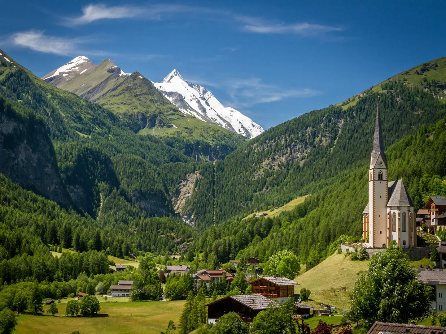
The route starts near Heiligenblut beneath the Grossglockner, Austria’s highest mountain, and heads south-east through Hohe Tauern National Park, the Möll valley, Millstätter See, the Nockberge and Wörthersee lakes. Near the three-country corner it drops to Tarvisio and Monte Lussari in Italy, then climbs into Slovenia at Kranjska Gora, following the Soča/Isonzo Valley through the Triglav National Park area past Bovec and Tolmin. It re-enters Italy at Cividale del Friuli and continues via the Brda/Collio wine hills and the Karst plateau to Muggia. It is a waymarked point-to-point trail, so plan transfers separately. For other Austrian long-distance options, compare the Hohe Tauern Panorama Trail or the border-ridge Carnic High Trail.
History of the Alpe-Adria Trail
The Alpe-Adria Trail was launched in 2012 as a joint project by Kärnten Werbung, the Slovenian Tourist Board and the Friuli-Venezia Giulia Tourist Board. It was conceived as a “glacier to the sea” route linking three border regions and following symbolic “paths of peace” between Austria, Slovenia and Italy. The trail has also been named among National Geographic’s top trails.
Notable highlights
- Hohe Tauern National Park: The route begins beneath the glaciers of the Grossglockner, Austria’s highest mountain, in the largest national park in the Alps.
- Nockberge Biosphere Reserve: Rounded grassy summits such as Pfannock and Mallnock form the trail’s highest ground, with alpine walking around 1,800–2,200 m.
- Soča (Isonzo) Valley: The trail follows Slovenia’s vivid turquoise Soča river through the Triglav National Park area, passing Bovec and landscapes tied to the WWI Isonzo Front.
- Monte Lussari: A pilgrimage village above Tarvisio near the three-country corner, reached on foot or by cable car.
- Cividale del Friuli: A UNESCO-listed town of Lombard heritage on the River Natisone, marking the descent towards the Friulian lowlands.
- Brda/Collio wine hills and Karst: Vineyard country and limestone plateau walking lead towards Trieste and the Adriatic finish at Muggia.
Challenges to expect
The Alpe-Adria Trail is not technically severe: there are no rope-secured or seriously exposed sections in the verified route description. The challenge is scale. Expect long daily stages, changing mountain weather, gravel and dirt tracks, rocky paths and some asphalt. Alpine stages may involve daily ascents up to about 1,500 m, and snow can linger into early summer. Book ahead in July–August, when accommodation can reach capacity. Stronger alpine hikers may also consider the Eagle Walk or the Gastein Valley Trail.
HikeList Score
Alpe-Adria Trail scored 84/100 on HikeList's trail-quality metrics.
See score breakdownHide breakdown
- Ideal length 52
- Balanced challenge 100
- Scenery & wildness 98
- Varied terrain 71
- Accommodation 83
- Food & support 88
- Path quality 98
- Season flexibility 89
Computed from length, challenge, scenery & wildness, terrain variety, accommodation, food & support, path quality and season flexibility.
 Austria
Show more data Show less
- Mountainous
- Forest
- Gravel
- Dirt
- Rocky
- Hotels
- Hostels
- Huts
- Family Friendly
- Pet Friendly
- Restrooms
- Water Sources
- Campsites
- Shelters
Photos from hikers
Taken on the trail by people who've reviewed Alpe-Adria Trail.
The trail starts at the iconic pilgrimage town of Heiligenblut beneath the Grossglockner, Austria’s highest peak. This stage follows the River Möll downstream, traversing alpine meadows and passing through small traditional settlements until reaching the tranquil village of Döllach.
Leaving Döllach, the stage weaves through the picturesque Möll Valley, crossing wooded slopes and remote hamlets. The route follows enchanting riverside paths, ascending gently to reach Innerfragant, surrounded by alpine scenery.
This section climbs steadily through forested areas and upland pastures. Enjoy views of roaring mountain streams before descending towards the charming village of Mallnitz in the heart of Hohe Tauern National Park.
From Mallnitz, the path leads across lush meadows and through cool forests, gradually descending. The trail offers scenic views of the Mölltal Valley and crosses small bridges before ending in the historic village of Obervellach.
This stage follows the river and winds through farmland and peaceful forest tracks. Ascend gently to the hilltop pilgrimage site of Danielsberg, offering views of the surrounding valleys and a sense of alpine tranquility.
From Danielsberg, descend towards Lake Millstatt. The trail follows quiet country roads through small villages, open meadows, and ends in the medieval town of Gmünd, known for its historic towers and castle.
Cross rolling foothills as you leave Gmünd, passing by forests and rural landscapes with vistas of the surrounding mountains. The day finishes along the southern shore of the scenic Lake Millstatt in Seeboden.
The stage traces the northern shore of Lake Millstatt, featuring lakeshore paths, woodland trails, and panoramic viewpoints. Pass through the charming town of Millstatt, notable for its Benedictine monastery.
The route leaves the lake behind and ventures through gentle hills, forest corridors, and pastures. Finish the day in Döbriach, a relaxed lakeside community with inviting swimming spots.
Embark on an ascent into the Nockberge Biosphere Reserve. The stage showcases open highland pastures, gentle summits, and pockets of ancient forest, finishing in the secluded Langalmtal valley.
Travel deeper through the Nockberge region, with undulating trails, mountain pastures, and traditional huts. The day ends at Falkerthaus, nestled amidst rolling green summits.
A scenic trek through alpine pastures leads towards the spa town of Bad Kleinkirchheim. The stage passes farmsteads and enters forests, with opportunities for thermal relaxation at the end of the day.
Today, the route traverses the gentle Nockberge foothills, gradually descending through mixed forests and meadows to Arriach, reputedly the geographical center of Carinthia.
Descend towards Lake Ossiach through forested valleys and peaceful uplands. The final stretch leads to the lakeside resort town of Ossiach, passing by its famous abbey.
Enjoy lakeside trails and gentle hills en route to Velden, an elegant lakeside town on the shores of Lake Wörthersee, famous for its promenade and vibrant atmosphere.
Meander through woodland paths, open fields, and rural villages before arriving at the turquoise Lake Faak. The day ends at Faak am See, a popular spot for swimming and relaxation.
Ascend into the Karawanken mountains, which form the border with Slovenia. The route climbs forested hills, offering panoramic views of the lakes and valleys below, before reaching Baumgartnerhöhe.
Cross the Austrian-Italian border, traversing dense forests and alpine trails before descending into Tarvisio, a vibrant Italian town known for its blend of cultures and excellent cuisine.
This Italian stage heads west through scenic alpine terrain, following forested tracks and passing the picturesque village of Camporosso before ending in Valbruna, surrounded by dramatic peaks.
Today features a substantial climb up into the Julian Alps. The route passes meadows and dense woodland, ascending to the welcoming mountain hut, Rifugio Zacchi, near the Lago di Fusine.
The path enters Slovenia, descending from alpine landscapes into the lively resort town of Kranjska Gora, with its mountain backdrop and outdoor activity options year-round.
Trek high into Triglav National Park, passing through beautiful pine forests and alpine meadows, traversing the scenic Vršič Pass—the highest road pass in Slovenia—before a long descent to Trenta.
The Soča River is your companion today, following turquoise waters through narrow gorges, lush forests, and wildflower meadows to the adventure hub of Bovec.
Travel through remote valleys and past tranquil villages surrounded by high peaks. The trail ascends past waterfalls and old hilltop churches, arriving at the peaceful village of Dreznica.
Descend through forests and upland pastures, with views across the Soča Valley. The stage finishes in Tolmin, a town known for its nearby gorge and history as a WWI front.
The hike continues south through rolling hills and mixed woodland, crossing the border back into Italy. The day ends in Tribil di Sopra, a small village in the eastern Friuli hills.
Follow quiet country roads and forest trails through peaceful Italian countryside, gradually ascending to the hilltop sanctuary of Castelmonte, one of Italy’s oldest pilgrimage sites.
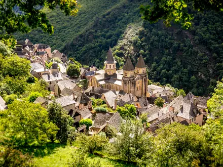
Descend from Castelmonte through vineyards and olive groves. Enter the historic UNESCO town of Cividale del Friuli, crossing the famous Devil’s Bridge over the Natisone River.
The trail leaves Cividale del Friuli, passing through the Collio wine region. Enjoy sweeping views and vineyard walks before arriving in the culinary village of Prepotto.
Explore rural Friuli landscapes, passing hamlets and farmlands, before reaching the walled town of Gradisca d'Isonzo, steeped in Habsburg and Venetian history.
Head south towards the Adriatic, passing through the mouth of the Isonzo River before reaching the dramatic coastline at Duino. Here, soaring cliffs overlook the sea and the famous Duino Castle awaits.
Walk the scenic Rilke path along limestone cliffs, with wide views over the Gulf of Trieste. Pass Mediterranean vegetation and reach the seaside village of Sistiana.
Continue along the Karst plateau overlooking the Adriatic, meandering through stone villages and vineyards. The day ends in the town of Prosecco, famed for its sparkling wine.
Today’s journey leads you through Mediterranean landscapes and rocky terrain, skirting the edge of the Karst region, and concludes in the quiet hamlet of Santa Croce.
Move inland and pass through karstic fields and stone villages, following a route of rural roads, paths, and forested tracks before reaching Basovizza on the outskirts of Trieste.
The penultimate stage traverses the southern Karst, offering glimpses of Trieste and the Adriatic. After a descent through olive groves and coastal forests, the route reaches the colorful port town of Muggia, the trail’s final destination.
Enjoy a celebratory coastal walk exploring the Muggia peninsula. This relaxed final stage brings sweeping sea views, fishing harbors, and the opportunity to reflect on the full length of the Alpe-Adria Trail journey.
Reviews
How would you rate Alpe-Adria Trail?
Tap a star to start your review — you could be the first.