Vrmac Ridge Trail
How would you rate Vrmac Ridge Trail?
Tap a star to share your experience and help other hikers.
Vrmac Ridge Trail: Fort Vrmac to Sveti Ilija
HikeList Score
Vrmac Ridge Trail scored 80/100 on HikeList's trail-quality metrics.
See score breakdownHide breakdown
- Ideal length 55
- Balanced challenge 100
- Scenery & wildness 98
- Varied terrain 83
- Accommodation 57
- Food & support 74
- Path quality 98
- Season flexibility 76
Computed from length, challenge, scenery & wildness, terrain variety, accommodation, food & support, path quality and season flexibility.
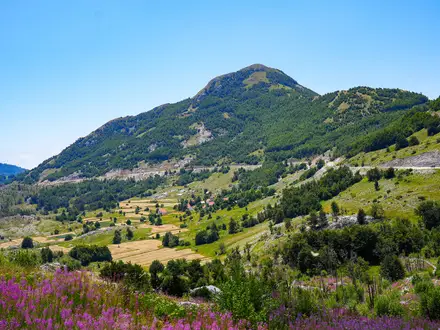
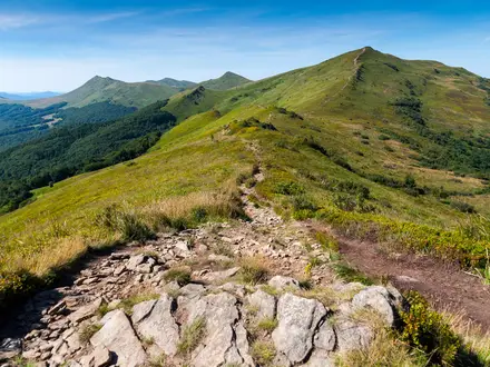
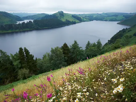
The Vrmac Ridge Trail is an 8.5 km moderate out-and-back ridge walk in south-western Montenegro, crossing the green Vrmac massif between the Bay of Kotor and Tivat Bay. The standard route starts at Fort Vrmac and follows the old Austro-Hungarian military road to Sveti Ilija, the ridge high point. It suits hikers wanting a half-day coastal mountain walk with big Kotor, Tivat and Adriatic views, without committing to the longer Kotor-to-Tivat traverse.
Route Overview
Start and finish at the Fort Vrmac car park, reached by a short drive or by the steep 4–4.5 km, roughly 500 m climb from Kotor Old Town or Muo. From the abandoned fortress, follow the old military road along the Vrmac ridge towards the broadcasting/transmitter tower and Sveti Ilija summit, then return the same way. The 8.5 km listing is this Fort Vrmac to Sveti Ilija out-and-back; the longer linear option continues down the Tivat side to Gornja Lastva and Donja Lastva. For other Montenegro day walks, compare the coastal Budva to Sveti Stefan Coastal Path and Bar to Old Ulcinj Trail, or the higher Bobotov Kuk Summit Trail.
Fort Vrmac and the Austro-Hungarian Kotor defences
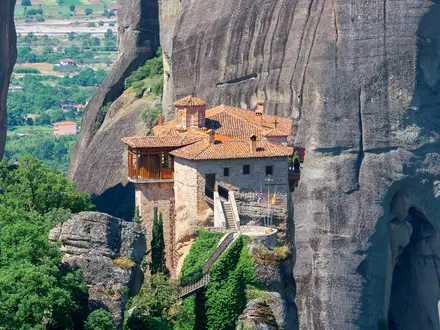
Vrmac was part of the Austro-Hungarian fortification chain built to defend the naval base at Kotor. An initial fort was established on the ridge in 1860, then replaced by the present Fort Vrmac between 1894 and 1897 after the Krivošije uprisings. Built with reinforced stone and concrete, armoured casemates and Škoda guns, it was heavily bombarded from Mount Lovćen during the First World War. The fort remains abandoned but largely intact.
Notable highlights
Fort Vrmac (Austro-Hungarian fortress): The hike starts at this abandoned mountain fort. Its casemates, ditch and tunnels can be explored with care, and there are no entry fees.
Sveti Ilija summit (785 m): The highest point of the Vrmac massif and the standard turnaround point. A concrete structure marks the summit area, with wide views over both sides of the ridge.
Bay of Kotor panorama: The ridge gives continuous bird’s-eye views over the fjord-like Bay of Kotor, Kotor’s walled old town and the Adriatic. The bay is part of a UNESCO World Heritage site.
Tivat and Porto Montenegro views: The southern side of Vrmac looks down to Tivat, Tivat Bay and the Porto Montenegro marina.
Old military road and pine forest: The route follows the wide, well-graded Austro-Hungarian road along the ridge, with shaded pine sections before more exposed viewpoints. Spring brings wildflowers along the track.
Challenges to expect
The Fort Vrmac to Sveti Ilija route is not technically hard, but it is still a moderate mountain walk. Expect sustained climbing, gravel and dirt track, plus loose rocky switchbacks near the summit. The open ridge can be hot and shadeless in high summer, while winter may be wet. Starting from Kotor or Muo adds a steep sea-level approach. Fort Vrmac is abandoned and unguarded, so explore cautiously.
HikeList Score
Vrmac Ridge Trail scored 80/100 on HikeList's trail-quality metrics.
See score breakdownHide breakdown
- Ideal length 55
- Balanced challenge 100
- Scenery & wildness 98
- Varied terrain 83
- Accommodation 57
- Food & support 74
- Path quality 98
- Season flexibility 76
Computed from length, challenge, scenery & wildness, terrain variety, accommodation, food & support, path quality and season flexibility.
Show more data Show less
- Mountainous
- Coastal
- Forest
- Gravel
- Rocky
- Dirt
- Hotels
- Family Friendly
- Pet Friendly
- Water Sources
- Picnic Areas
Photos from hikers
Taken on the trail by people who've reviewed Vrmac Ridge Trail.
Start at the Fort Vrmac car park and follow the old Austro-Hungarian military road along the ridge towards Sveti Ilija, passing ridge viewpoints over Kotor, Muo, Tivat and Donja Lastva. Turn around at the Sveti Ilija summit area and return the same way.
Reviews
How would you rate Vrmac Ridge Trail?
Tap a star to start your review — you could be the first.