Via Dinarica (White Trail - Croatian Section)
How would you rate Via Dinarica (White Trail - Croatian Section)?
Tap a star to share your experience and help other hikers.
Via Dinarica White Trail Croatia: Expert Thru-Hike Guide
HikeList Score
Via Dinarica (White Trail - Croatian Section) scored 74/100 on HikeList's trail-quality metrics.
See score breakdownHide breakdown
- Ideal length 56
- Balanced challenge 48
- Scenery & wildness 85
- Varied terrain 83
- Accommodation 84
- Food & support 81
- Path quality 98
- Season flexibility 89
Computed from length, challenge, scenery & wildness, terrain variety, accommodation, food & support, path quality and season flexibility.
The Via Dinarica White Trail Croatian section is a roughly 550 km point-to-point mountain thru-hike across Croatia, usually planned at about 30 days. It is the largest national section of the Via Dinarica White Line, linking the high Dinaric Alps from Gorski Kotar to Dinara on the Bosnia and Herzegovina border. This is an expert route: expect long remote stages, scarce water, rocky karst, exposed ridges, overgrown paths and inconsistent waymarking. It suits self-sufficient hikers with strong navigation and mountain experience.
Route Overview
Walked north-to-south as part of the full Slovenia-to-Albania White Trail, the Croatian section enters from Slovenia via Razloge and Crni Lug in Risnjak National Park. It crosses Gorski Kotar, Velika Kapela and Bijele i Samarske stijene, then runs through or near the Velebit spine: Northern Velebit, Zavižan, Hajdučki i Rožanski kukovi, the Premužić Trail and Paklenica. The route continues inland to Knin and finishes on the Dinara massif via Brezovac hut, Sinjal and the Glavaš hut area before entering Bosnia and Herzegovina. It is a linear thru-hike, not a loop. For a more coast-focused Croatian mountain route, compare the Adriatic Long-Distance Trail.
How the Croatian White Line Fits the Via Dinarica
The Via Dinarica project began around 2010 as a cross-border initiative to link the Dinaric Alps into one hiking corridor, with support from international development programmes such as UNDP and USAID. The Croatian White Line is not a newly cut path throughout: it stitches together older Croatian mountaineering routes, including the Gorski Kotar, Kapela and Velebit hiking trails, plus historic shepherd and mountain paths. Its best-known built section is the Premužić Trail, engineered in 1930–1933 under forester Ante Premužić.
Notable highlights
- Premužić Trail (Premužićeva staza): A drystone-engineered path across Northern Velebit, built in 1930–1933. It is the standout maintained section, threading rugged karst while staying unusually gentle underfoot.
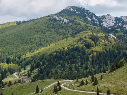
- Northern Velebit National Park: High limestone ridges, the Zavižan area and the Hajdučki and Rožanski kukovi strict reserve. Hikers get wild karst scenery, rare alpine flora and Adriatic views.
- Paklenica National Park: A dramatic section of deep limestone gorges below Velebit’s highest summits, including Vaganski vrh. It is also a famous rock-climbing area and marks a steep descent towards the coast.
- Risnjak National Park: The leafy Croatian gateway in Gorski Kotar, near the source of the Kupa River. Expect fir and beech forest in habitat associated with lynx, brown bear and wolf.
- Dinara / Sinjal (1,831 m): Croatia’s highest peak and the high point of the Croatian White Line. The Dinara massif also gives the Dinaric range and Via Dinarica their name.
- Bijele i Samarske stijene: A strict nature reserve in the Velika Kapela range, known for white limestone towers and rugged karst terrain.
Challenges to expect
This is a difficult, lightly serviced mountain route. Croatian stages can be overgrown, with ticks, nettles and inconsistent markings; GPS tracks and offline maps are strongly recommended. Water is scarce on the exposed karst, especially in summer, and resupply requires careful planning. Expect rocky limestone, forest tracks, long remote sections, heat, sudden weather changes and exposed ridges. For shorter Croatian walks, see the Krka Waterfalls Trail or Jankovac Forest Trail.
HikeList Score
Via Dinarica (White Trail - Croatian Section) scored 74/100 on HikeList's trail-quality metrics.
See score breakdownHide breakdown
- Ideal length 56
- Balanced challenge 48
- Scenery & wildness 85
- Varied terrain 83
- Accommodation 84
- Food & support 81
- Path quality 98
- Season flexibility 89
Computed from length, challenge, scenery & wildness, terrain variety, accommodation, food & support, path quality and season flexibility.
 Croatia
Show more data Show less
- Mountainous
- Karst
- Forest
- Rocky
- Dirt
- Gravel
- Huts
- Shelters
- Guesthouses
- Wild Camping Spots
- Pet Friendly
- Water Sources
- Campsites
- Shelters
In these collections
Photos from hikers
Taken on the trail by people who've reviewed Via Dinarica (White Trail - Croatian Section).
Begin your journey in the village of Razloge, located on the outskirts of Risnjak National Park, and head toward the park’s main settlement, Crni Lug. This section sets the tone for the trail with lush forests, mountain scenery, and the possibility of spotting local wildlife like deer or lynx. Entering Risnjak National Park, you follow well-maintained forest paths with several scenic viewpoints overlooking the park’s diverse landscape.
Departing Crni Lug, you traverse forested uplands and follow trails leading toward the bustling town of Delnice, a mountain hub in the Gorski Kotar region. Expect rolling hills, dense forest, and occasional clearings offering panoramic vistas. As you approach Delnice, the landscape alternates between quiet village roads and tranquil woodland paths.
From Delnice, continue southeast through evergreen forests, passing by the tranquil Lokvarsko Lake and small rural villages. The route is relatively gentle but punctuated by undulating terrain and occasional rocky outcrops. You finish the day at the settlement of Lokve, a peaceful stop with access to supplies and rest.
Hike southward, leaving Lokve behind and gradually ascending through pristine forest and open meadows toward Mrkopalj. The region is known for its winter sports, but in summer, it provides a tranquil mountain hiking experience. Along the way, you encounter small streams, traditional homes, and an abundance of wildflowers in season.
Heading deeper into Gorski Kotar, this day’s trek continues over forested slopes and minor mountain passes to Begovo Razdolje, Croatia’s highest permanently inhabited village. Expect spectacular views as you gain elevation, with refreshing forest canopies and a chance to spot local fauna.
Today’s route leads you from Begovo Razdolje over rolling hills and through charming woodland. The path skirts isolated homesteads and gradually drops to the pastoral valley of Jasenak. Expect relative solitude, with the gentle sound of nature your constant companion.
Gradually descending, your path traverses a mosaic of meadows and mixed forests as you head toward Jezerane. Occasional open vistas reveal the scale of the surrounding mountains. This area is lightly populated, so plan for limited facilities.
Leaving Jezerane, begin a longer journey south toward Korenica, gateway to the renowned Plitvice Lakes. Much of the day is spent on forest tracks and undulating hills, punctuated by occasional settlements. Near Korenica, larger guesthouses and services become available.
A shorter trek brings you from Korenica directly into the northern entrance of Plitvice Lakes National Park. Marvel at world-famous waterfall cascades and turquoise lakes, following marked park trails through forests beside the park’s unique karst features. Overnight options are abundant in and near the park entrance.
Dedicate a full day to uncovering Plitvice Lakes National Park’s beauty. Walk along park boardwalks and trails that loop around the upper and lower lakes, reconnecting with nature’s wonders at every turn. This is a highlight of the Croatian White Trail, with its iconic waterfalls and emerald pools.
Exit the southern side of Plitvice Lakes and make your way to the quiet village of Ličko Petrovo Selo. The terrain alternates between forest road and open, rocky fields. This section offers peaceful walking, with the chance to observe traditional rural landscapes.
Continue hiking south, transitioning from rolling countryside into the foothills of the Velebit. Pass by isolated hamlets and through light oak woodlands, catching glimpses of distant mountains that will soon dominate your horizon.
Leaving Donji Lapac, ascend gently toward Bruvno. These rarely trodden paths offer utter solitude and immersion in nature, leading between patches of forest and pockets of karst terrain. The day finishes in Bruvno, a small settlement on the edge of the Velebit massif.
Begin the ascent into the Velebit range, traversing rugged slopes and pine-covered ridges. The path follows shepherd trails and minor roads, gaining elevation with each step. You reach Oštarije, a traditional mountain pass settlement at the gateway to Northern Velebit.
Ascend further into Velebit, enjoying cooler air and ever-broader vistas. The well-marked trail connects you to Baške Oštarije, a popular stop for hikers and cyclists. Expect uneven and rocky tracks, with expansive meadows and mountain flora.
This challenging day includes an ascent into the heart of Northern Velebit National Park. The iconic Premužić Trail, famous for its panoramic views and clever stonework, begins here. Overnight at Zavižan mountain hut or nearby shelters, surrounded by rugged beauty.
A highlight of the trek, this stage follows the dramatic Premužić Trail. Traverse high ridgelines with sea views to the west, pass karst sinkholes, and gaze down at the Adriatic coastline. The trail leads to the Alan mountain hut, an important shelter for hikers in the region.
Descend from Alan along the rugged spine of the Velebit, crossing remote and wild terrain with sweeping views down to the valleys. The trail eventually leads to Veliko Rujno, a historic mountain plateau with a small chapel and seasonally accessible shelter.
From the high pastures of Veliko Rujno, descend a panoramic path toward Starigrad Paklenica at the foot of the Velebit. This village, just inland from the Adriatic Sea, provides resupply opportunities and access to Paklenica National Park.
Utilize this day to explore Paklenica’s dramatic canyons and reach the famous Anića Kuk cliff, a haven for climbers and hikers alike. Navigate steep, rocky paths, and enjoy the park’s unique geological formations. Return to Starigrad or camp inside the park.
A shorter hike takes you from Starigrad through scenic lowlands and foothills to the neighboring settlement of Seline. This provides a breather with chances to enjoy the Adriatic views, short coastal walks, and a different climate zone.
Climb out of the coastal zone, returning into rugged karst inland. The route passes abandoned hamlets and wild stretches, showcasing the striking transition between the sea and the mountains. You spend the night in or near Radučić, a small rural outpost.
Continue traversing remote territory, entering the hinterland of Gračac. Here, gently rolling plains alternate with rocky hills and sparse forests. Gračac serves as a key resupply stop with shops and accommodation.
This is one of the longer stages as you journey across wide open countryside and past small villages toward the historic town of Knin. Expect to walk on lesser-used tracks with sporadic tree cover and distant mountain views. Knin’s fortress and amenities await at your destination.
Leaving the urban bustle of Knin behind, climb gently into the foothills of Dinara Mountain. The scenery rapidly becomes more rugged as you approach Glavaš, the traditional gateway for ascents of Croatia’s highest peak. Sparse woodland and karst terrain characterize this section.
Ascend steeply from Glavaš to the summit of Dinara (Sinjal, 1,831m), the highest point in Croatia. The climb is demanding, with exposed rocky trails and expected rapid weather changes. From the peak, descend to the mountain shelter at Brezovac, where alpine conditions dominate.
Begin your descent from the high Dinaric ridge, making your way toward the village of Kijevo. The path is rugged, passing high grassland, patches of forest, and offering views toward the valleys below. This is a quieter, less-developed part of the region.
Travel south on moderate terrain, passing through scattered rural settlements, karst fields, and occasional pine woods. Strmica, close to the Bosnia and Herzegovina border, marks the final village before the end of the Croatian White Trail.
The final leg is a short walk from Strmica to the Croatian border, where you complete the Croatian section of the Via Dinarica White Trail. This marks the transition point into Bosnia and Herzegovina for those continuing the journey.
Use this final day as a buffer for weather delays, rest, or further exploration of the Dinara region and Knin. Alternatively, begin your journey home via Knin’s transport connections.
Reviews
How would you rate Via Dinarica (White Trail - Croatian Section)?
Tap a star to start your review — you could be the first.