Verzasca Valley Trail
How would you rate Verzasca Valley Trail?
Tap a star to share your experience and help other hikers.
Verzasca Valley Trail: Route 74 Through Ticino’s Stone Villages
HikeList Score
Verzasca Valley Trail scored 86/100 on HikeList's trail-quality metrics.
See score breakdownHide breakdown
- Ideal length 59
- Balanced challenge 100
- Scenery & wildness 98
- Varied terrain 83
- Accommodation 92
- Food & support 88
- Path quality 80
- Season flexibility 89
Computed from length, challenge, scenery & wildness, terrain variety, accommodation, food & support, path quality and season flexibility.
The Verzasca Valley Trail is the official Sentiero Verzasca, SchweizMobil route 74, a 34.7 km point-to-point hike in Val Verzasca, Ticino, Switzerland. It runs from Sonogno to Locarno and is best walked downhill over 1–2 days. Difficulty is moderate: SAC T2 mountain hiking, with stony mule-track sections but generally clear waymarking. It suits hikers who want a scenic valley route with river pools, stone villages, forest, and easy PostBus access.
Route Overview
The official route runs the length of the Verzasca Valley from Sonogno, the last and highest village, to Locarno Debarcadero on Lake Maggiore. Most hikers walk south, descending via Frasco, Gerra, Brione Verzasca, Lavertezzo, then above Lake Vogorno through Corippo and Mergoscia to Locarno. The full route is normally split into two stages: Sonogno–Lavertezzo and Lavertezzo–Locarno. PostBus line 321 links Locarno railway station with the valley villages up to Sonogno, so shorter sections are easy to plan. For another Locarno-area day hike, see the Cardada Cimetta Panorama Trail; for a much bigger Swiss crossing, compare the Alpine Pass Route.
Mule Tracks, Stone Villages and the Modern Verzasca
Val Verzasca was long a poor, isolated farming and herding valley, connected by mule tracks that now form much of the hiking route. From the mid-1800s many villages lost population as residents emigrated. The Ponte dei Salti and Corippo are reminders of that older valley life, while the 1960s Contra Dam and later film fame helped shift the area toward tourism. In 2020 the historic communes of Sonogno, Frasco, Gerra, Brione, Corippo and Vogorno merged into the municipality of Verzasca.
Notable highlights
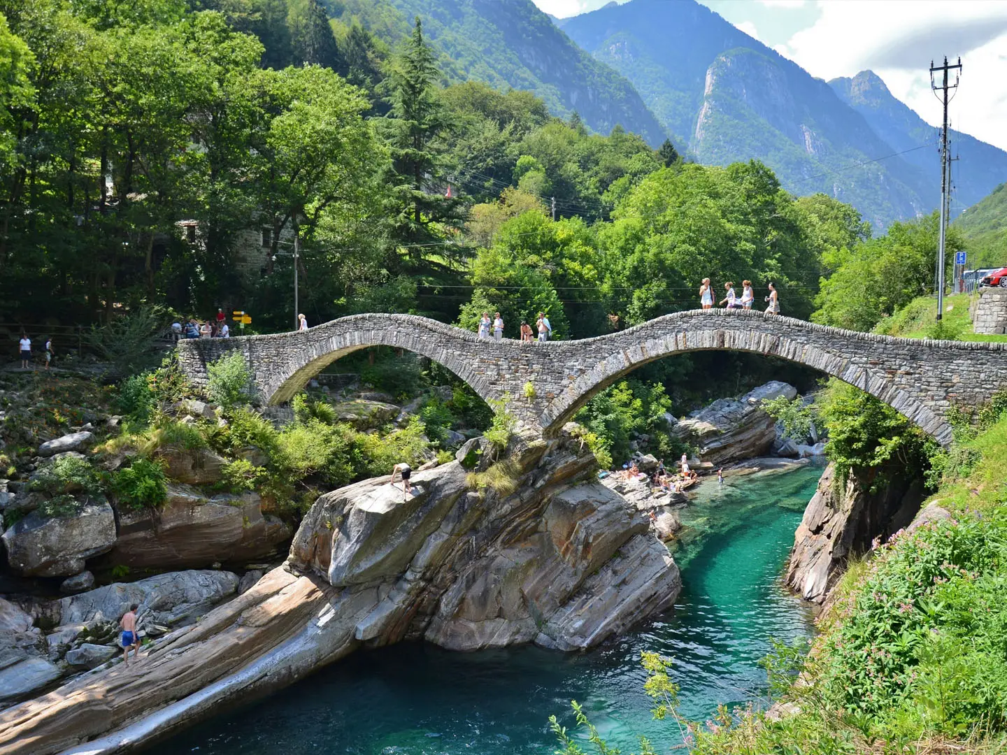
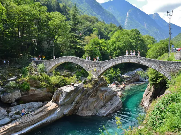
- Ponte dei Salti, Lavertezzo: The valley’s signature double-arched stone bridge crosses the emerald Verzasca. Built in the 17th century on an earlier crossing, it is often nicknamed the “Roman bridge”, though it is not Roman.
- Emerald pools of the Verzasca River: Clear jade-green water runs over smooth granite, forming pools and small cascades. It is a major summer swimming and freediving spot, but currents can be dangerous.
- Corippo: A tiny stone village above Lake Vogorno, long known as Switzerland’s smallest municipality before the 2020 merger into Verzasca. Restored rustic houses now form part of an albergo diffuso village hotel.
- Sonogno: The final village at the head of the valley has a well-preserved stone centre, the Casa della Lana, an ethnographic museum, and access to the nearby Cascata della Froda waterfall.
- Verzasca / Contra Dam: Near the valley mouth, the 220 m arch dam holds back Lake Vogorno and is famous for the GoldenEye bungee jump from the 1995 James Bond opening.
- Stone villages and chestnut groves: Frasco, Gerra and Brione Verzasca give the route its old Ticinese character, with stone houses, small churches, terraced fields and chestnut woods.
Challenges to expect
The trail is moderate rather than technical, but do not treat the full route as a casual stroll: Sonogno to Locarno is about 11h30 walking time with 2,040 m of descent. Expect stony mule tracks, rocky riverside paths, short paved or road sections, and heat in summer. Snow can linger early or late in the season. Navigation is straightforward on yellow Swiss signs marked route 74. If planning harder Swiss mountain routes, compare the Bernina Trek or the Aletsch Glacier Panorama Trail.
HikeList Score
Verzasca Valley Trail scored 86/100 on HikeList's trail-quality metrics.
See score breakdownHide breakdown
- Ideal length 59
- Balanced challenge 100
- Scenery & wildness 98
- Varied terrain 83
- Accommodation 92
- Food & support 88
- Path quality 80
- Season flexibility 89
Computed from length, challenge, scenery & wildness, terrain variety, accommodation, food & support, path quality and season flexibility.
 Switzerland
Show more data Show less
- Mountainous
- Forest
- River
- Dirt
- Rocky
- Paved
- Hotels
- Guesthouses
- Huts
- Campsites
- Family Friendly
- Pet Friendly
- Restrooms
- Water Sources
- Campsites
- Picnic Areas
Download Our Full Guide to Verzasca Valley Trail FREE!
Get our comprehensive guide to this hike for free. Save it for later reading or print out at home.
Photos from hikers
Taken on the trail by people who've reviewed Verzasca Valley Trail.
Verzasca Valley Trail: The Complete Guide
 i
Image by Matty G.
i
Image by Matty G. The Verzasca Valley Trail is a waymarked valley walk through one of Ticino’s most distinctive landscapes, following SvizzeraMobile route 74 from Sonogno down towards Locarno and Lago Maggiore. It suits walkers who want stone villages, chestnut woods and clear river pools rather than a high summit objective.
The route begins at the head of Val Verzasca in Sonogno, then works south through Frasco, Gerra (Verzasca), Brione (Verzasca) and Lavertezzo. Along the way, cobbled mule tracks and forest paths keep close to the emerald Verzasca River, with Ponte dei Salti providing the valley’s best-known landmark.
Beyond Lavertezzo the walk becomes longer and more varied, climbing onto the hillside above Lago di Vogorno via Corippo and Mergoscia before descending towards Locarno. The final approach passes Madonna del Sasso above Orselina, then drops to the Debarcadero on Lake Maggiore.
This is not a technical trek, but it is still a mountain hiking route graded SAC T2. The full 34.7 km walk has around 902 m of ascent and a much larger 2,040 m of descent, with stony tracks, rocky riverside sections, paved stretches and real heat in summer.
PostBus 321 makes the trail unusually easy to shorten, start late or split into two days, but summer services can be busy and accommodation in the small valley villages is limited. River swimming is a major draw, though cold water and dangerous currents mean the Verzasca should be treated with care.
This guide covers stages, day options, accommodation, food, transport, terrain and the common planning mistakes to avoid.
Stage-by-Stage Guide
Stage 1: Sonogno to Lavertezzo
Distance: 13.6 km
Typical walking time: about 3h50
Profile: mainly downhill, with about 25 m of ascent and about 398 m of descent
This is the gentler half of the Sentiero Verzasca and the best section for walkers wanting the classic upper-valley experience without committing to the long finish into Locarno. From Sonogno, the official yellow SchweizMobil / SvizzeraMobile route 74 signs lead out of the village and down-valley beside the Verzasca.
The stage follows the old valley line through Frasco, Gerra (Verzasca) and Brione (Verzasca) before reaching Lavertezzo. Expect a mix of cobbled mule track, forest path, stony riverside walking, short paved lanes and occasional road-side sections rather than a continuous soft footpath.
Sonogno is worth allowing time for before starting, especially if visiting the stone village centre, Casa della Lana, the ethnographic museum in Casa Genardini or the nearby Cascata della Froda. Once on the trail, the character is very Ticinese: rustici stone houses, small churches, terraced slopes, chestnut groves and repeated glimpses of the emerald Verzasca running over pale granite.
The route is well waymarked, but the walking is not completely trivial. The path can be rocky underfoot close to the river, and wet stone or polished cobbles can be slippery after rain. In hot summer weather, the lower altitude and enclosed valley make this stage feel warmer than its mountain setting might suggest.
Lavertezzo is the natural overnight stop on the standard two-day itinerary. The village is known for the Ponte dei Salti, the double-arched 17th-century stone bridge over the Verzasca, and is one of the busiest places in the valley in summer.
Food, drink and accommodation are possible in the valley villages, but services are small-scale and can be seasonal. Carry enough water and food for the stage rather than relying on every village having an open stop, and book beds in or near Lavertezzo well ahead in summer.
PostBus line 321 gives useful access throughout this stage, running between Locarno railway station, Tenero and Sonogno, with stops in the valley villages. This makes Sonogno–Lavertezzo easy to walk as a day section, but buses can be very busy on summer weekends and current times should be checked before travelling.
The Verzasca’s clear pools are a major draw, especially around Lavertezzo, but the river is not a harmless swimming pool. Cold water, submerged rocks and dangerous currents are real hazards; treat any swim or paddle as a separate risk decision, not part of the walking route.
Stage 2: Lavertezzo to Locarno (Debarcadero)
Distance: 21.3 km
Typical walking time: about 7h30
Profile: the harder stage, with the main remaining ascent and a long descent to Lake Maggiore
This is the longer and more committing half of route 74. It starts at Lavertezzo, leaves the best-known riverside scenery behind, then climbs onto the hillside above Lago di Vogorno before crossing towards Locarno and descending to the Debarcadero on Lago Maggiore.
From Lavertezzo, the trail continues south through the lower Val Verzasca and then rises towards Corippo. This tiny granite and slate-roofed village, now known for its albergo diffuso village hotel, is one of the most distinctive settlements on the route and marks the transition from river-valley walking to the higher balcony section.
Between Corippo and Mergoscia the path traverses the flanks above Lago di Vogorno. This is where the route feels most like a mountain walk rather than a valley stroll, with broader views over the green reservoir and the lower valley. The walking remains SAC T2, but the day’s length, stony surfaces and accumulated descent make it more tiring than the first stage.
The official route passes Mergoscia, Monti di Lego, Brione sopra Minusio and Orselina before dropping past Madonna del Sasso above Locarno. The sanctuary is the final major landmark and gives a strong sense of arrival, with Locarno and Lago Maggiore below.
A key navigation point is that route 74 does not finish at Vogorno and does not go through Vogorno village or across the Verzasca / Contra Dam. The trail stays on the high flank above Lago di Vogorno via Corippo and Mergoscia, then continues all the way to Locarno, Debarcadero.
Food and water planning matters more on this stage because it is long. There are villages on or near the route, but services should not be assumed to be open, especially outside the main season or later in the day. Start from Lavertezzo with enough water and snacks for several hours of walking.
Accommodation at the end is much easier than in the upper valley. Locarno has far more choice than the small Val Verzasca villages, while Lavertezzo and Corippo have limited small-scale options for walkers splitting the route.
Public transport remains useful for shortening the day. PostBus line 321 serves the valley between Locarno, Tenero and Sonogno, although some services use Tenero station as the interchange for the train to or from Locarno. Check current timetables before travelling, particularly if planning to leave the route part-way through the day.
The main warnings on this stage are practical rather than technical: start early, expect heat in summer, and allow time for the final descent. Stony mule tracks and paved sections can be hard on tired feet, while early- or late-season snow or path conditions should be checked before committing to the full traverse into Locarno.
Recommended Itinerary
Standard itinerary: 2 days
This is the most sensible end-to-end plan for most walkers. It uses the two established stages, keeps the first day manageable after reaching Sonogno by PostBus, and leaves the longer hillier section for a full day finishing in Locarno.
| Day | From | To | Approx. distance | Why this stage makes sense | Services/accommodation notes |
|---|---|---|---|---|---|
| 1 | Sonogno | Lavertezzo | 13.6 km | A natural upper-valley stage following the Verzasca downstream through the older stone villages and river scenery. The distance is moderate, mostly net downhill, and gives time for the journey up to Sonogno before starting. | Sonogno, Frasco, Gerra (Verzasca), Brione (Verzasca) and Lavertezzo have limited village services and small-scale accommodation. Lavertezzo is the obvious overnight stop because it sits at the end of the first stage and gives access to Ponte dei Salti, but beds are limited and should be booked well ahead in summer. PostBus 321 gives exit options along the valley. |
| 2 | Lavertezzo | Locarno, Debarcadero | 21.3 km | The longer and more demanding day, with the route leaving the easy riverside character for the balcony traverse above Lago di Vogorno via Corippo and Mergoscia, then descending past Orselina and Madonna del Sasso into Locarno. Start early, especially in hot weather. | Locarno has far more accommodation and onward transport than the valley villages. Carry enough food and water for the day rather than relying on continuous services between villages. The official finish is Locarno, Debarcadero on Lago Maggiore, not Vogorno or the Verzasca dam. |
Slower variant: 3 days or section-walking by PostBus
A slower plan suits families, hot summer conditions, swimmers who want unhurried time by the river, and walkers who prefer shorter days on stony ground. Exact stage lengths depend on where accommodation is available, so check official mapping before booking.
| Day | From | To | Approx. distance | Why this stage makes sense | Services/accommodation notes |
|---|---|---|---|---|---|
| 1 | Sonogno | Brione (Verzasca) or another upper-valley village | Check official mapping before booking | Shortens the first day and allows more time in Sonogno, Frasco, Gerra (Verzasca) and the upper Verzasca riverside sections. | Beds in the upper valley are limited. If no suitable bed is available, use PostBus 321 to return to Locarno or Tenero and resume the route the next day. This should be checked before travelling. |
| 2 | Brione (Verzasca) or chosen valley stop | Lavertezzo or Corippo | Check official mapping before booking | Keeps the Ponte dei Salti and Lavertezzo area unhurried, then optionally continues towards Corippo to shorten the final day. | Lavertezzo is popular and can be busy; Corippo has an albergo diffuso village-hotel option. Availability should be checked early for summer dates. |
| 3 | Lavertezzo or Corippo | Locarno, Debarcadero | Check official mapping before booking | Leaves the Lago di Vogorno balcony traverse, Mergoscia, Monti di Lego, Brione sopra Minusio, Orselina and Madonna del Sasso for a dedicated final stage. | Finish in Locarno for the widest choice of hotels, restaurants and rail connections. If using PostBus links to adjust the start point, confirm current times before travelling. |
Another practical slow option is to base in Locarno or Tenero and walk the trail as separate day sections using PostBus 321. This avoids moving luggage between small valley villages and makes it easier to adapt the walk in very hot weather or if accommodation in Lavertezzo is full.
Faster variant: 1 long day
A one-day traverse is possible for fit walkers who are comfortable with a long T2 mountain-hiking day. The official full route is 34.7 km with an approximate walking time of 11h30, around 902 m of ascent and about 2,040 m of cumulative descent.
| Day | From | To | Approx. distance | Why this stage makes sense | Services/accommodation notes |
|---|---|---|---|---|---|
| 1 | Sonogno | Locarno, Debarcadero | 34.7 km | Best for strong hikers who want the complete route in one push and can maintain steady progress over stony mule tracks, riverside paths, paved stretches and the higher traverse above Lago di Vogorno. The challenge is endurance and descent, not technical difficulty. | Take an early PostBus to Sonogno and expect busy buses on summer weekends. Do not plan this version around long swimming stops. Locarno is the practical place to stay at the end; confirm current PostBus 321 times before travelling. |
Planning the Route
How many days to allow
Most walkers should plan the Sentiero Verzasca as a two-day walk rather than trying to complete the whole route in one push. The official full-route walking time is around 11h30, before breaks, swimming stops, village visits or transport connections, so a one-day itinerary is only sensible for fit walkers starting early and moving efficiently.
The standard split is practical because Lavertezzo sits roughly between the gentler upper-valley section and the longer, hillier second stage towards Locarno. The second day is the one to treat with more respect: it includes the higher balcony traverse above Lago di Vogorno via Corippo and Mergoscia, then the final approach over Orselina and Madonna del Sasso.
| Stage | Route | Planning note |
|---|---|---|
| Day 1 | Sonogno to Lavertezzo — 13.6 km | Shorter and more forgiving; good for a late start only if transport and accommodation are secure. |
| Day 2 | Lavertezzo to Locarno, Debarcadero — 21.3 km | Longer, with more ascent than the “down-valley” direction suggests; start early in warm weather. |
A slower itinerary also works well. The valley is suited to shorter village-to-village days, especially for families, swimmers and walkers who want time in Sonogno, Lavertezzo, Corippo or at Madonna del Sasso rather than simply covering distance.
Direction and stage logic
Plan to walk from Sonogno down-valley to Locarno. This follows the official route direction, makes use of the net descent to Lake Maggiore and fits naturally with PostBus access from Locarno or Tenero to the valley head.
Do not underestimate the second half because the route is generally descending. The trail leaves simple riverside walking for a higher traverse above Lago di Vogorno, passing Corippo and Mergoscia before the wooded descent towards Locarno.
The official route finishes at Locarno, Debarcadero on Lago Maggiore. It does not finish at Vogorno, does not pass through Vogorno village, and does not cross the Verzasca / Contra Dam; the trail stays on the flank above the lake via Corippo and Mergoscia.
Shortening, section hiking and bail-out options
This is one of the easiest Ticino walks to shorten because PostBus line 321 runs along Val Verzasca between Locarno/Tenero and Sonogno, stopping at the valley villages. That makes Sonogno, Frasco, Gerra (Verzasca), Brione (Verzasca) and Lavertezzo useful access or exit points for shorter sections.
Section hiking is very practical. A common approach is to walk only the upper valley to Lavertezzo, or to use the bus to create shorter days based around the villages rather than committing to the full 34.7 km at once.
Check the current PostBus 321 timetable before travelling. Some services terminate at Tenero station, with the Tenero–Locarno leg completed by train, and buses can be very busy on summer weekends.
Accommodation planning
Accommodation is the key booking issue if walking over two days. The small upper-valley villages have limited beds in small hotels, guesthouses, osterie, grotti and rustici-style rooms, so summer weekends and holiday periods need advance booking.
Lavertezzo is the natural overnight point for the standard two-day split, but limited availability means it is sensible to have a backup plan. If staying elsewhere in the valley, make sure the next morning’s bus connection puts you back on the route without losing too much walking time.
Corippo has an albergo diffuso village-hotel model, while Locarno has far more accommodation choice at the finish. Campsites also exist in the wider valley area, but opening dates, locations and booking requirements should be checked before travelling.
Food and water
Do not plan this as a wilderness resupply route, but do not assume every small village service will be open when needed either. Carry lunch or substantial snacks, especially for the longer Lavertezzo–Locarno stage and for days outside the busiest summer period.
Summer heat is a real planning factor in Val Verzasca. Start early, carry enough water for each stage, and treat village refills or café stops as useful bonuses rather than guarantees unless opening times have been checked.
The Verzasca’s pools are tempting in hot weather, especially around Lavertezzo, but the river has cold water and dangerous currents. Swimming stops can also add a lot of time to the day, so build them into the plan rather than letting them delay the final kilometres.
Navigation and maps
The route is waymarked as SchweizMobil / SvizzeraMobile route 74 with yellow hiking signs, so navigation is generally straightforward in clear conditions. Still, carry a proper map or offline mapping because the route changes character several times: riverside paths, village lanes, stony mule tracks, forest sections and the higher traverse above Lago di Vogorno.
The SchweizMobil app or online map is the most direct digital planning tool for route 74. Swisstopo 1:25,000 mapping covering the Val Verzasca, including sheets such as 1312 Locarno and 1292 Maggia, is useful for walkers who prefer paper mapping or want wider terrain context.
Pay particular attention after Lavertezzo and around the Corippo–Mergoscia section, where the route is not simply following the valley floor. Follow the yellow “74” waymarks rather than aiming for Vogorno or the dam.
Weather, season and gear choices
Spring, summer and autumn are the normal walking seasons, but conditions still need checking close to departure. Snow may linger early or late in the season, and hot weather in summer can make the long second day feel harder than the statistics suggest.
Footwear matters more than technical equipment. The route is graded SAC T2 rather than alpine scrambling, but there are stony mule tracks, rocky riverside sections and cumulative descent that can be tiring on feet and knees.
Before setting out, check the local forecast, current path conditions, river warnings and transport times. For this route, the most important planning decisions are accommodation, bus logistics, heat management, water, and allowing enough time for the long Lavertezzo–Locarno stage.
Towns, Villages and Overnight Stops
Accommodation in Val Verzasca is small-scale. Expect village guesthouses, osterie, grotti, rustici-style rooms and some campsites rather than large hiker hostels. Beds in the upper valley are limited, especially in summer, so the overnight stop should be booked before committing to a two-day itinerary.
Food planning needs the same caution. Several villages have seasonal or limited opening hours, and not every stop should be treated as a reliable resupply point. Check accommodation, meals and shop opening times before travelling, particularly outside the main summer period.
Sonogno
Sonogno is the start of the official route and the last, highest village at the head of Val Verzasca. The yellow SchweizMobil / SvizzeraMobile 74 signs lead out from the village, making it the cleanest place to begin the trail.
It can work as a pre-hike overnight stop if an early start is wanted, but accommodation is limited and should be booked well ahead in summer. The village is small, so do not rely on turning up late and finding a room.
For food, expect village-scale services rather than a full supermarket-style resupply. Check current opening hours for restaurants, osterie or shops before travelling, especially if arriving in the evening.
PostBus 321 links Sonogno with Locarno and Tenero, with the full valley journey taking roughly 70 minutes. Buses can be very busy on summer weekends, so allow time and avoid planning a tight connection at the start of the day.
Sonogno is also worth allowing time for before walking: the stone village centre, Casa della Lana, the ethnographic museum in Casa Genardini and the nearby Cascata della Froda are all practical reasons to arrive the afternoon before rather than rushing straight onto the trail.
Frasco
Frasco is the first village down-valley from Sonogno on the opening section towards Lavertezzo. It sits in the upper-valley part of the route, where the walking is still closely tied to the Verzasca and the old stone-village landscape.
It is more useful as a rest or short-stage point than as the default overnight base. Accommodation may exist in the wider village area, but beds are limited in the upper valley and availability should be checked before travelling.
Food options should also be treated as limited and seasonal. Carry enough snacks and water for the stage rather than assuming every village will provide an open café, shop or meal.
Frasco is on the Val Verzasca PostBus 321 corridor, so it is a practical point for shortening the first stage or joining the route part-way down the valley. Current bus times should be checked before relying on it for a same-day exit.
Gerra (Verzasca)
Gerra (Verzasca) is another upper-valley settlement between Frasco and Brione (Verzasca). It is useful for breaking the walking rhythm, taking shelter, or leaving the route by bus if the day is getting too long or too hot.
As an overnight stop, Gerra is possible only if suitable accommodation is booked in advance. The upper valley has a small bed base, so this is not a place to depend on for last-minute availability.
Food and drink services should be checked before travelling. Hikers should carry what they need for the day, particularly outside peak summer or when walking early or late.
PostBus 321 serves the valley villages, making Gerra a workable access or exit point for section-hiking. This is one of the reasons the Sentiero Verzasca is easy to divide into shorter walks.
Brione (Verzasca)
Brione (Verzasca) lies on the upper half of the route before Lavertezzo. It has the same practical role as Frasco and Gerra: a village stop on the way down-valley, useful for pacing, shelter and public-transport flexibility.
It can be considered for an overnight only with an advance booking. Small hotels, guesthouses, osterie and rustici-style rooms are part of the accommodation mix in the valley, but capacity is limited and uneven from village to village.
Food availability should not be assumed. Check current opening times if planning lunch or dinner here, and carry enough supplies to continue to Lavertezzo if services are closed.
Brione (Verzasca) is on the PostBus 321 valley route, giving a straightforward way to shorten the Sonogno–Lavertezzo stage. As with all Val Verzasca bus planning, weekend summer crowding and current timetables matter.
Lavertezzo
Lavertezzo is the main overnight choice for the standard two-day split. It is the end of the first stage from Sonogno and the start of the longer second stage to Locarno, so it is the most logical place to stop if walking the route over two days.
Accommodation should still be booked early. Lavertezzo is a popular valley village, especially because of the Ponte dei Salti and the emerald Verzasca pools, and demand can be high in summer.
Food options are more likely here than in the smallest upper-valley villages, but opening hours and meal availability still need checking before travel. If staying overnight, confirm whether dinner and breakfast are available at the accommodation or nearby.
PostBus 321 makes Lavertezzo a very useful start or finish point for day walks. It also gives an escape option if the first stage takes longer than expected, or if summer heat makes continuing unattractive.
The local note that matters most is safety around the river. The water is beautiful and popular for swimming and diving, but it can be cold and currents can be dangerous; do not let a lunch stop at the bridge turn into a careless swim.
Corippo
Corippo sits above Lago di Vogorno on the second stage, after the route leaves the valley-floor character and climbs onto the hillside. It is one of the most distinctive overnight possibilities on the trail because of its albergo diffuso, a dispersed village hotel using rooms within the old settlement.
This can be an excellent stop for walkers who want to turn the route into a slower two- or three-day trip rather than using the standard Sonogno–Lavertezzo–Locarno split. Capacity is limited by the nature of the village, so reservations are essential.
Food arrangements should be confirmed at the time of booking. Do not assume that separate shops or multiple restaurants will be available in such a small settlement.
Transport from Corippo should be planned carefully. The main valley PostBus 321 is the key public-transport spine for Val Verzasca, but the exact access point and current service pattern for a Corippo start or exit should be checked before travelling.
Corippo is also a useful navigation reminder: the trail passes above Lago di Vogorno via Corippo and Mergoscia. It does not go through Vogorno village or across the Verzasca / Contra Dam.
Mergoscia
Mergoscia comes after Corippo on the balcony traverse above Lago di Vogorno. This is the part of the trail where the route feels less like a simple riverside valley walk and more like a hillside crossing with views over the reservoir.
It can be used as a quiet overnight stop if accommodation is available, but it is not the default stage-break village for most hikers. Check beds, meals and transport before building an itinerary around staying here.
Food and drink options should be treated as limited unless booked or checked in advance. Carry enough water and snacks for the Corippo–Mergoscia–Locarno section, as this is the longer second stage.
Public transport from Mergoscia is not detailed in the route information used for this guide. This should be checked before travelling if Mergoscia is planned as a start, finish or overnight point.
Monti di Lego
Monti di Lego is on the latter part of the route between Mergoscia and the descent towards the Locarno side. It is best understood as a route point rather than a main service village.
Do not plan on it as a normal overnight stop unless accommodation has been specifically identified and booked. This should be checked before travelling.
Food, shops and transport should not be assumed here. Treat this section as part of the continuous walk towards Brione sopra Minusio, Orselina and Locarno, and carry what is needed for the day.
Its practical value is mainly as a waypoint on the long second stage. If energy, weather or daylight are becoming an issue before this point, the better decision is usually to use an earlier confirmed transport exit rather than hoping for services ahead.
Brione sopra Minusio
Brione sopra Minusio is reached as the route comes closer to the Locarno urban area after the hillside section above Lago di Vogorno. It marks the transition from valley and forest walking towards the built-up lakeside finish.
It may be possible to find accommodation in or near the area, but Locarno has far more choice and is the more practical overnight base at the end of the hike. If stopping here, book and confirm access details in advance.
Food and local services are more plausible this close to Locarno than in the upper valley, but specific opening times should still be checked before relying on them. This is particularly important if arriving late after the long Lavertezzo–Locarno stage.
Local transport details for Brione sopra Minusio are not covered by the main Val Verzasca PostBus information. This should be checked before travelling if using it as an exit point.
Orselina
Orselina sits above Locarno on the final descent. By this point the route is leaving the mountain and valley terrain and dropping towards the lakeside town.
It is usually not necessary as an overnight stop unless the aim is to stay above Locarno rather than in the town itself. Locarno is the more useful base for rail connections, broader accommodation choice and post-hike services.
Food and accommodation may be available in the wider Orselina area, but details should be checked before booking a plan around it. For most hikers, Orselina is a final-stage waypoint rather than a logistics hub.
Transport from Orselina should be checked before travelling if needed. Otherwise, continue down past Madonna del Sasso to finish at Locarno, Debarcadero as signed by the official route.
Madonna del Sasso
Madonna del Sasso is not an overnight stop in the hiking-planning sense, but it is an important final landmark above Locarno. The route passes the sanctuary and viewpoint before descending into town.
It is a good place to pause before the last drop to the lake, especially if the long second stage has been walked from Lavertezzo. Keep time in hand, though: the official finish is still down at Locarno, Debarcadero, not at the sanctuary.
Food, accommodation and transport planning should be focused on Locarno or the wider Orselina area rather than on the sanctuary itself. Any local opening hours or access arrangements should be checked before travelling.
Locarno, Debarcadero
Locarno, Debarcadero is the official finish on Lago Maggiore. The trail descends into town after passing Madonna del Sasso, ending at the lakeside boat landing rather than at Vogorno, the dam or another valley-mouth point.
This is by far the easiest place on the route for an overnight after finishing. Locarno has much more accommodation choice than the small villages of Val Verzasca, making it the safest base for late arrivals, rest days or onward travel.
It is also the best place for post-hike food, supplies and transport connections. Locarno railway station is on the Swiss rail network, including the Centovalli line and connections via the Gotthard base tunnel towards Lucerne and Zurich.
PostBus 321 links Locarno with the Verzasca valley via Tenero, although some services run only to or from Tenero station with the Tenero–Locarno leg by train. Check current timetables before travelling, especially on summer weekends when buses are busy.
Getting to the Start
By train
Sonogno has no railway station. The usual railhead for the Verzasca Valley Trail is Locarno, where the route finishes at Locarno, Debarcadero on Lake Maggiore.
Locarno is on the Swiss rail network, with connections including the Centovalli line and routes via the Gotthard Base Tunnel towards Lucerne and Zurich. From Locarno, continue by PostBus up Val Verzasca to Sonogno.
If starting the trail immediately after arriving by train, allow a sensible buffer at Locarno station before the valley bus. Current rail and bus connections should be checked before travelling.
By bus
PostBus line 321 is the key access service for this hike. It runs from Locarno railway station via Tenero up Val Verzasca to Sonogno, stopping at the valley villages along the way.
The full Locarno–Sonogno journey takes about 70 minutes end to end, with services roughly hourly. For part of the day, some buses terminate at Tenero station, with the Tenero–Locarno leg made by train instead. This should be checked before travelling.
Line 321 is also what makes the route easy to shorten or section-hike, as it serves the main valley settlements including places such as Lavertezzo. In summer, especially at weekends, buses can be very busy because the Verzasca pools and villages are popular day-trip destinations; start early and avoid relying on the last possible connection.
At Sonogno, the official SchweizMobil / SvizzeraMobile route 74 yellow waymarks lead out from the village.
By car
Driving to Sonogno is possible in principle, but it is not the most convenient way to tackle a point-to-point hike ending in Locarno. If a car is left at the start, the return journey from Locarno still requires travelling back up the valley by public transport or taxi.
A more practical car-based plan is usually to leave the vehicle near the finish area and take PostBus 321 up to Sonogno before walking back towards Locarno. Specific parking locations, long-stay rules and charges are not covered here and should be checked before travelling.
Road access into Val Verzasca can be busy in summer, particularly around the popular river spots. Build in extra time if travelling on a fine weekend or during holiday periods.
Taxi use is best treated as a fallback for awkward arrival times rather than the main plan. Availability and fares from Locarno, Tenero or the valley villages should be checked before travelling.
From the nearest airport
For international arrivals, the practical approach is to connect into the Swiss rail network and travel by train to Locarno, then take PostBus 321 to Sonogno. Rail routes towards Locarno include connections via the Gotthard corridor from the north.
Airport choice, rail transfer times and late-arrival connections vary by season and timetable. This should be checked before travelling, especially if trying to reach Sonogno the same evening.
Where to stay before starting
For the easiest morning logistics, stay in Locarno and take an early PostBus up the valley to Sonogno. Locarno has far more accommodation than the small villages in Val Verzasca and is the simplest base if arriving by rail the previous evening.
Staying in Sonogno puts you directly at the start and is useful for an early, quiet departure, but accommodation in the upper valley is limited. Beds in small hotels, guesthouses, osterie and rustici-style rooms should be booked well ahead in summer.
If splitting the trail into two days, some walkers instead position themselves around the valley using PostBus 321 and begin from the relevant stop. Always match accommodation plans to the current bus timetable rather than assuming late or frequent evening services.
Getting Home from the Finish
The official finish is Locarno, Debarcadero on Lago Maggiore (Lake Maggiore). Locarno is the easiest place on the route to leave from: it has the main railway station for onward travel, far more accommodation than the valley villages, and connections back up Val Verzasca if you have left luggage or a car at an intermediate stop.
By train
Locarno railway station is the main public-transport hub at the finish. From the lakeside Debarcadero, continue into central Locarno to reach the station for onward rail travel.
Locarno is connected to the Swiss rail network, including the Centovalli line and routes via the Gotthard base tunnel towards Lucerne and Zurich. Exact connections, journey times and the last trains of the day are timetable-dependent and should be checked before travelling.
If finishing late after the full Sonogno–Locarno traverse, check the last viable rail connection before committing to onward travel the same evening. Locarno is a sensible overnight stop if the final descent from Madonna del Sasso takes longer than expected or if onward connections become tight.
By bus
PostBus line 321 is the key route for returning up Val Verzasca. It runs from Locarno railway station via Tenero towards Sonogno, stopping at the valley villages, including Lavertezzo and the upper-valley stops used for stage starts and finishes.
Services are roughly hourly, but some journeys terminate at Tenero station, with the Tenero–Locarno section made by train. Buses can be very busy on summer weekends, especially around the popular river and swimming spots, so allow time and avoid relying on the final bus without checking the current timetable.
Use the bus if you need to return to accommodation in Lavertezzo, retrieve a car left at a valley stop, or reverse a shortened stage. If the plan depends on one specific evening departure, this should be checked before travelling.
By car/taxi
For drivers, the cleanest logistics are usually to treat Locarno as the end-point hub and use PostBus 321 to reach the start or recover a vehicle left in Val Verzasca. The route is point-to-point, so parking at Sonogno and walking all the way to Locarno leaves a long public-transport return up the valley at the end of the hike.
Taxis are most practical from Locarno rather than from the smaller valley villages, but availability and fares can vary. Book ahead if a taxi is needed for a late finish, luggage transfer or a return to a specific accommodation address. This should be checked before travelling.
From the nearest airport
For international departures, plan the airport leg around rail connections from Locarno station rather than expecting a direct trailhead transfer. Locarno’s onward rail links connect into the wider Swiss network, including routes towards Zurich via the Gotthard base tunnel.
Airport choice and journey times depend on the flight route and current rail timetable. This should be checked before travelling, especially if trying to fly out on the same day as completing the walk.
Where to stay at the finish
Locarno has far more accommodation than the small villages in Val Verzasca, making it the best place to stay after finishing the full route. It is also the safest option if you expect a long walking day, hot weather, or a late arrival into town.
Staying in Locarno keeps the next morning simple: the railway station is nearby for onward travel, and PostBus 321 can be used to return up the valley if luggage, accommodation or a parked vehicle is elsewhere. Book ahead in the main summer season, when both Locarno and the Verzasca valley are busy.
Which Direction Should You Walk?
The standard and official direction for SvizzeraMobile route 74 is Sonogno to Locarno, following the Val Verzasca downstream from the head of the valley to Lago Maggiore (Lake Maggiore). This is the direction most walkers should choose, especially for a first end-to-end walk.
Standard direction: Sonogno to Locarno
Walking south from Sonogno gives the route its natural downhill logic. The trail starts in the highest village at the head of the valley, follows the Verzasca through Frasco, Gerra (Verzasca), Brione (Verzasca) and Lavertezzo, then climbs onto the flank above Lago di Vogorno via Corippo and Mergoscia before descending past Madonna del Sasso into Locarno.
This direction has a large net descent: the route drops from about 918 m at Sonogno to about 196 m at Locarno Debarcadero. There is still around 902 m of cumulative ascent, so it is not a simple downhill stroll, but it avoids turning the route into a much bigger uphill day.
Transport also works well this way. Locarno is on the rail network and has far more accommodation than the small valley villages, so many walkers base themselves in or near Locarno, take PostBus 321 up to Sonogno, then walk back towards the town. If walking the full route in a long day, finishing at Locarno avoids having to catch a late bus out of Sonogno at the end.
The scenery also builds well in this direction. The upper valley gives the most intimate river-and-village walking, Lavertezzo and Ponte dei Salti arrive as a natural mid-route highlight, and the second half opens out onto the balcony traverse above Lago di Vogorno before the final descent to the sanctuary of Madonna del Sasso and the lakeside finish at Locarno Debarcadero.
The main drawback is the amount of descent. Around 2,040 m of cumulative downhill on cobbled mule tracks, rocky riverside path and stony forest sections can be tiring on knees and feet, particularly if attempting the full 34.7 km in one day. Poles are useful if you are prone to sore knees on long descents.
Reverse direction: Locarno to Sonogno
Walking from Locarno to Sonogno is possible, but it changes the character of the route. The cumulative descent becomes the cumulative climb, turning the walk into a much more demanding uphill outing with around 2,040 m of ascent overall.
The reverse can appeal to strong walkers who prefer climbing to long descents, or to anyone who wants the route to feel progressively more remote, ending in the stone village of Sonogno rather than in the busier lakeside town of Locarno. It also means the final kilometres are in the quieter upper valley rather than on the approach into town.
The logistics are less forgiving in reverse. Sonogno is served by PostBus 321, but it is a small valley village, and finishing there means timing the onward bus back down the valley. Buses can be very busy on summer weekends, and current timetables should be checked before travelling.
Accommodation flow is also less convenient for most itineraries. Locarno has the widest choice of beds, while accommodation in the upper valley is limited and should be booked well ahead in summer. A reverse two-day itinerary may still work, but it needs more careful planning around Lavertezzo, Sonogno and bus times.
Recommendation
For almost all walkers, the best direction is Sonogno to Locarno. It follows the official waymarked direction, makes best use of public transport, keeps the biggest climb out of the itinerary, and gives a satisfying finish at Lago Maggiore with rail connections and plenty of accommodation.
Choose the reverse only if you are deliberately looking for a harder uphill version, have checked the PostBus 321 timetable carefully, and are comfortable finishing in a small upper-valley village rather than in Locarno.
Accommodation Along the Route
Accommodation on the Verzasca Valley Trail is workable, but it is not evenly spread. The upper and middle valley has small-scale lodging — small hotels, guesthouses, osterie, grotti, rustici-style rooms and some campsites — while Locarno has by far the widest choice at the finish.
For a standard two-day walk, Lavertezzo is the most practical overnight stop because it sits at the end of the official first stage from Sonogno. Beds in and around the valley villages are limited, so summer weekends should be booked well ahead, especially if the itinerary depends on sleeping in Lavertezzo or Corippo.
Best overnight strategy
Most inn-to-inn walkers will use one of three approaches:
- Sleep in Sonogno before starting, then walk Sonogno–Lavertezzo and Lavertezzo–Locarno over two days.
- Start early from Locarno by PostBus 321 to Sonogno, overnight in Lavertezzo, then finish in Locarno the next day.
- Base in Locarno and day-walk sections by PostBus, avoiding the need to find a valley bed at all.
The third option is often the simplest if accommodation in the valley is full. PostBus 321 runs up the valley from Locarno railway station via Tenero to Sonogno and stops at the valley villages, allowing shorter sections to be linked without carrying overnight kit. Some services involve Tenero station for the Locarno connection; current timetables should be checked before travelling.
Accommodation by place
| Place | Accommodation level | Best for | Notes |
|---|---|---|---|
| Sonogno | Limited | Pre-walk overnight; early start from the head of the valley | Small upper-valley village with limited beds. Useful if avoiding a very early bus from Locarno. Book ahead in summer. |
| Frasco, Gerra (Verzasca), Brione (Verzasca) | Limited | Flexible valley stops; shorter section walks | These villages can help if splitting the route more gently, but do not assume walk-up availability. Check opening dates and booking conditions before fixing the itinerary. |
| Lavertezzo | Limited | Main two-day overnight stop | The natural break between the official Sonogno–Lavertezzo and Lavertezzo–Locarno stages. Demand can be high in warm weather because of Ponte dei Salti and the river pools. |
| Corippo | Limited | Character overnight; slower itinerary | Home to an albergo diffuso, with rooms spread through the historic village setting. Capacity is limited, so this needs advance booking rather than a last-minute plan. |
| Mergoscia | Limited | Alternative stop on the hillside section above Lago di Vogorno | Potentially useful for breaking the long second day, but accommodation choice should be checked before building the route around it. |
| Orselina / Madonna del Sasso area | Limited | Near-finish stop above Locarno | Practical only if a specific booking suits the itinerary. Most walkers continue down into Locarno for greater choice. |
| Locarno | Good | Finish night; base for day walks; backup if valley beds are full | By far the strongest accommodation base, with rail access and PostBus links into Val Verzasca. Still worth booking ahead for summer weekends and busy holiday periods. |
Booking pressure and seasonality
Val Verzasca is popular in spring, summer and autumn, and summer weekends bring extra pressure from day visitors heading for the river, Ponte dei Salti and the valley villages. The trail itself is short enough for a one-night itinerary, but that also means many walkers want the same obvious overnight point at Lavertezzo.
Book valley accommodation before committing to travel dates. This matters more than on routes with larger towns every few kilometres: a full guesthouse in a small village may mean changing the stage plan or using the PostBus to reach a bed elsewhere.
Campsites are part of the valley accommodation mix, but opening periods, pitch availability and reservation rules vary. These should be checked before travelling, especially outside the main summer season.
Luggage and transfers
This route works well for independent inn-to-inn walking because it is only one or two days long and has regular public transport access. Most walkers can carry a light overnight pack without needing a formal baggage service.
For bag-free walking, the most reliable planning method is to stay in Locarno and use PostBus 321 to reach or leave each section. Taxi transfers may be possible in the valley, but availability and costs should be checked before travelling. Dedicated luggage-transfer arrangements should not be assumed when booking small village accommodation.
Camping and Wild Camping
Camping is possible on the Verzasca Valley Trail, but it is not the most natural way to tackle the route. The walk is only 34.7 km, is commonly split into Sonogno–Lavertezzo and Lavertezzo–Locarno, and is well served by PostBus 321, so most hikers will find guesthouses, rustici-style rooms or Locarno accommodation simpler than carrying overnight camping kit.
That said, there are campsites in the valley and around the Locarno end of the route. Specific campsite locations, opening dates, booking rules and prices change seasonally and should be checked before travelling, especially for summer weekends when the valley is busy.
Campsites and where camping makes sense
For a two-day itinerary, camping is most useful if you want to overnight around the middle of the route rather than stay in Lavertezzo or use the bus. It can also work if Locarno accommodation is expensive or full, but expect far more formal options near the lake and town than in the small upper-valley villages.
Do not assume that every village has camping facilities. Sonogno, Frasco, Gerra (Verzasca), Brione (Verzasca), Lavertezzo, Corippo and Mergoscia are small places, and accommodation capacity is limited in the upper valley. Check campsite availability in advance and have a fallback using PostBus 321.
| Section | Camping practicality |
|---|---|
| Sonogno to Lavertezzo | Better suited to a light overnight in booked accommodation or a campsite arranged in advance. Villages are small and summer demand is high. |
| Lavertezzo to Locarno | Less attractive for carrying full camping kit: this is the longer day, with the climb to the balcony traverse above Lago di Vogorno and the final descent past Madonna del Sasso. Formal camping near the Locarno end may be more practical than trying to camp along the route. |
Wild camping
Wild camping should not be assumed to be allowed in the Val Verzasca. The route passes through villages, chestnut woods, riverside areas, cultivated or private land, road-accessible swimming spots and the built-up approach to Locarno, so it is a poor route for informal camping even where a discreet overnight might seem possible.
Rules can depend on the municipality, land ownership, protected areas and seasonal fire restrictions. This should be checked before travelling. If permission cannot be obtained, use an official campsite or booked accommodation instead.
Avoid camping beside the Verzasca River or on river-polished rock and gravel near pools. The river is beautiful but can be dangerous, with cold water and strong currents, and the most popular riverside areas around places such as Lavertezzo are heavily used in summer.
Water, stoves and Leave No Trace
The Verzasca runs close to much of the route, but river water should not be treated as a guaranteed safe drinking source without filtration or purification. Carry enough water between villages, particularly in summer heat and on the longer Lavertezzo–Locarno stage.
Campfires are not appropriate unless explicitly permitted at an official site or designated place. Local fire restrictions can change quickly in dry weather, so stove use and fire rules should be checked locally before travelling.
If camping anywhere on or near the route, keep impact minimal: use existing official facilities, pitch only where permitted, pack out all rubbish, do not wash directly in the river, and avoid disturbing village edges, woodland, grazing areas and popular swimming spots. The trail is a busy, low-valley route rather than a remote backcountry traverse, so discretion and compliance with local rules matter.
Food, Water and Resupply
Food and water planning is straightforward if the trail is split sensibly, but the Val Verzasca is still a rural valley rather than a continuous strip of shops. Expect services in villages to be small, seasonal and sometimes tied to hotels, osterie, grotti or guesthouses rather than dedicated hiking resupply points.
Locarno has by far the best choice at the finish. In the valley, do not assume that every village has an open shop or café when you arrive, especially outside peak summer, on Sundays or late in the day. Opening times should be checked before travelling.
Food availability
For a two-day itinerary, the simplest plan is to buy the main trail food before travelling up to Sonogno, then use village accommodation or restaurants where booked. Sonogno, Frasco, Gerra (Verzasca), Brione (Verzasca), Lavertezzo, Corippo and Mergoscia are real settlements, but services are limited and not evenly spread along the route.
Lavertezzo is the natural mid-route stop and the most practical place to plan around for a two-day walk. Even so, walkers should not depend on turning up and finding food available without checking current opening times or booking ahead.
Stage 2 from Lavertezzo to Locarno is the longer and more committing food day. The route climbs away from the valley floor towards Corippo and Mergoscia before continuing to Brione sopra Minusio, Orselina, Madonna del Sasso and down to Locarno; carry enough food for the full stage unless a definite meal stop has been arranged.
Water
The trail follows the Verzasca for much of the upper valley and passes through several villages, but natural water should not be treated as automatically drinkable. If taking water from the river or side streams, filter or treat it first.
The Verzasca’s clear pools can be tempting in hot weather, but the river is cold and currents can be dangerous. Use it as a landmark and emergency water source only with treatment, not as a substitute for carrying enough drinking water.
In warm weather, start each stage with a full bottle or bladder. For the shorter Sonogno–Lavertezzo stage, most walkers should carry at least 1.5–2 litres, plus more if walking in high summer heat. For Lavertezzo–Locarno, carry at least 2 litres and top up wherever a reliable opportunity is available.
| Section | Food availability | Water availability | Notes |
|---|---|---|---|
| Sonogno to Lavertezzo | Limited village services and possible osterie/grotti or accommodation-based meals in the valley villages; do not rely on open shops without checking. | Carry water from the start. Possible top-ups only where services are open; natural water needs filtering or treatment. | Shorter official stage, but still carry lunch or substantial snacks unless a meal stop is planned. |
| Lavertezzo to Corippo / Mergoscia | Sparse and seasonal. Corippo has an albergo diffuso, but food availability should be checked before relying on it. | Start full from Lavertezzo. Natural sources are present in the wider valley but should be treated. | This is where the route leaves the easier valley-floor pattern and becomes less convenient for casual resupply. |
| Mergoscia to Locarno | Limited until the approach to Orselina and Locarno, where services become much easier. | Carry enough for the remaining descent, especially in hot weather. | The finish at Locarno Debarcadero gives the best access to food, shops and onward transport. |
Practical resupply strategy
For a one-day end-to-end walk, carry all food for the day from the outset. The full route is long, hot in summer and has enough ascent on the lower half that a café-dependent plan is risky.
For a two-day walk, carry breakfast items, lunch food and emergency snacks even if accommodation meals are booked. Small rural services can close for rest days, private events or seasonal breaks.
If using PostBus 321 to shorten the route, resupply becomes easier because stages can begin and end at valley villages or back in Locarno/Tenero. Bus times and current service patterns should be checked before travelling, especially on summer weekends when buses can be very busy.
Terrain, Conditions and Difficulty in Practice
The Sentiero Verzasca is graded SAC T2, so it is a mountain hiking route rather than a technical alpine route. The walking is generally on clear, signed paths, but it is not a smooth riverside promenade: expect cobbled mule tracks, stony forest paths, rocky riverbank sections, short paved lanes and some road stretches through and between villages.
The main difficulty is cumulative effort. The route loses far more height than it gains, with about 902 m of ascent but roughly 2,040 m of descent between Sonogno and Locarno Debarcadero. That long downhill profile is hard on knees and feet, especially if walking the full 34.7 km in one day.
Underfoot terrain
Much of the upper Val Verzasca walking follows old mule-track and village paths through Sonogno, Frasco, Gerra (Verzasca), Brione (Verzasca) and Lavertezzo. These surfaces can be uneven, cobbled and stony, with short stretches of lane or road where the route links settlements.
Beside the Verzasca River, the path includes rocky riverside ground and smooth granite around pools and cascades. Wet stone can be slippery, particularly after rain or near the water, so grippy footwear matters even though the route is not technically difficult.
The section beyond Lavertezzo becomes more demanding in character. The route climbs away from the valley floor onto the hillside around Corippo and Mergoscia, traversing above Lago di Vogorno before the long descent towards Brione sopra Minusio, Orselina, Madonna del Sasso and Locarno.
Stage-by-stage difficulty
| Section | Practical terrain and effort |
|---|---|
| Sonogno to Lavertezzo | The easier stage in terms of gradient, with modest ascent and steady descent through the upper valley. The walking is still stony in places, with mule tracks, forest paths, river sections and village lanes. |
| Lavertezzo to Locarno | The harder stage for most walkers. It is longer, takes around 7h30 on official timings, and includes most of the route’s climbing as it rises to the balcony traverse above Lago di Vogorno before descending all the way to Lake Maggiore. |
Splitting the walk over two days makes the route feel comfortably moderate for fit walkers. Completing it in one day is a much tougher undertaking because the official walking time is about 11h30, and the descent accumulates relentlessly.
Exposure, technical ground and navigation
There is no summit ridge, scrambling section or high-alpine pass on the normal route. The higher ground is mainly hillside and balcony walking rather than technical mountain terrain, but it should still be treated as a T2 mountain path, not an urban footpath.
Waymarking is a major advantage: follow the yellow SchweizMobil / SvizzeraMobile route 74 signs. Even so, the mix of village streets, lanes, forest tracks and path junctions means a map or offline route line is useful, especially if joining or leaving the trail at an intermediate village.
The key terrain concerns are stone, heat, distance and descent rather than livestock fields, stiles or fence navigation. No special stile or farm-field obstacle defines this route.
Weather and seasonal conditions
Spring, summer and autumn are the normal seasons. Early or late in the season, snow may linger on higher or shaded sections, and this should be checked before travelling.
Summer can be hot in Ticino, particularly on paved lanes, exposed stone and the lower approach to Locarno. Start early in hot weather, allow extra time, and do not underestimate fluid needs between villages.
After rain, cobbles, rock slabs, forest paths and riverside stone become more slippery. Autumn can be a good walking season, but damp leaves and wet stone can make the descent slower than the gradient suggests.
The Verzasca’s clear pools are a major attraction, but the river has cold water and dangerous currents. Treat swimming stops as separate from the hike itself, and check any current river or path warnings before travelling.
Weather and Best Time to Walk
The Sentiero Verzasca is primarily a spring, summer and autumn walk. It is not a high alpine route, but it still reaches about 1,116 m and includes stony mule tracks, rocky riverside sections and a higher balcony traverse above Lago di Vogorno, so conditions matter.
Best months
For most walkers, the best periods are late spring and autumn, when the valley is usually more comfortable for walking than in midsummer. These shoulder-season windows suit the long descent, the exposed paved sections and the second stage from Lavertezzo to Locarno, which is a full walking day.
Summer is very popular, especially around the river pools and Ponte dei Salti at Lavertezzo. It is also the season when heat becomes a real factor: the route finishes at low altitude in Locarno and includes road and paved stretches that can feel hot underfoot. Start early, carry more water than usual, and avoid treating the full Sonogno–Locarno route as an easy downhill day.
Early spring and late autumn can be excellent, but snow may linger early or arrive late in the season, especially on shaded or higher sections. Current path conditions should be checked before travelling.
Season-by-season planning
| Season | What to expect | Planning advice |
|---|---|---|
| Spring | Generally suitable, but early-season snow can remain or return on higher/shaded ground. Wet cobbles, stone steps and rocky riverside sections can be slippery after rain. | Check path conditions before travelling. Trekking poles are useful on the long descent if the trail is damp. |
| Summer | Fully walkable in normal conditions, but heat is the main difficulty. The Verzasca pools draw large numbers of visitors, and buses are very busy on summer weekends. | Start early, book valley accommodation well ahead, and allow extra time around popular stops such as Lavertezzo. Do not rely on a swim to cool down: the Verzasca has cold water and dangerous currents. |
| Autumn | Often one of the most practical seasons for the route, with less heat than summer and good conditions for a long valley walk. Later in the season, daylight shortens and snow becomes more possible. | Keep stages realistic, especially the 21.3 km Lavertezzo–Locarno stage. Check conditions if walking late in the season. |
| Winter | Not the normal season for this hike. Snow, ice, short daylight and reduced margin for errors make the full route a poor choice for a standard long-distance walk. | Treat winter attempts as condition-dependent mountain hiking. This should be checked before travelling. |
Rain, storms and trail surface
Rain mainly affects footing rather than navigation. The route is waymarked with yellow SchweizMobil / SvizzeraMobile route 74 signs, but wet cobbled mule tracks, stone village lanes, forest paths and polished riverside rock can become slippery.
After heavy rain, take particular care near the Verzasca River and on rocky riverbank sections. The emerald pools are attractive in warm weather, but the river is cold and can have dangerous currents; swimming and diving decisions should be kept separate from the walking plan.
Heat and daylight
The official walking time for the full route is about 11h30, so daylight is a real planning factor if attempting Sonogno to Locarno in one day. In shorter-day seasons, splitting the route at Lavertezzo is the safer and more realistic plan for most walkers.
In summer, the issue is the opposite: long daylight helps, but heat can make the net descent harder than it looks on paper. The route loses about 2,040 m overall, so knees, feet and water management matter more than the moderate SAC T2 grade might suggest.
Accommodation and transport by season
Beds in the small upper-valley villages are limited, and summer demand is high. Book accommodation early if planning a two-day itinerary with an overnight stop in or around Lavertezzo or another valley village; Locarno has far more choice at the finish.
PostBus 321 makes it easy to shorten the walk in any season when services are running, but summer weekend buses can be very busy. Current timetables and any service pattern involving a change at Tenero station should be checked before travelling.
Safety Notes
The Sentiero Verzasca is a waymarked SAC T2 mountain hiking route, not a technical alpine crossing, but it should still be treated as a mountain-valley walk. The main risks are length, accumulated descent, stony footing, summer heat, cold river water and occasional isolation between villages.
Emergency planning and phone signal
Know the current Swiss emergency numbers before setting off. This should be checked before travelling.
Do not rely on continuous mobile signal along the whole route, especially in the narrower upper valley, in forest, and on the hillside traverse above Lago di Vogorno. Download the SchweizMobil route map and relevant offline mapping before leaving Sonogno or Locarno, and carry enough battery for navigation and calls.
Solo walkers should leave a clear plan with someone else, especially if attempting the full Sonogno–Locarno route in one day. PostBus 321 provides useful exit points at the valley villages, but bus times should be checked before relying on them as a safety fallback.
Underfoot conditions
Much of the route uses cobbled mule tracks, stony forest paths and rocky riverside sections. These can be tiring on a long descent, particularly on the second stage from Lavertezzo to Locarno, where the day is longer and includes the higher traverse via Corippo and Mergoscia.
Use footwear with reliable grip rather than light city trainers. Poles are helpful for the cumulative descent, especially if knees are sensitive or if walking the route in one long day.
After rain, smooth stone, shaded cobbles and riverside rock can be slippery. Keep to the marked path and avoid shortcuts on steep or loose ground.
Heat, cold and weather
Summer heat is a real issue in Val Verzasca, despite the route staying at modest altitude. Start early in hot weather, carry more water than for a typical lowland walk, and use village stops to refill where possible.
The river and shaded woodland can make the route feel cooler than it is, but exposed paved stretches and the open balcony sections can still be draining. Sun protection is essential in clear weather.
In spring and autumn, conditions can change quickly and snow may linger early or late in the season. Check the forecast, current path conditions and any local warnings before setting off each day.
Verzasca River and swimming
The emerald pools of the Verzasca are one of the route’s main attractions, but the river is not a casual swimming spot everywhere. Currents can be dangerous, the water is cold, and smooth granite makes slips easy.
Only enter the water where conditions are clearly safe, and never jump into unknown pools. Avoid swimming after rain, when water levels and currents can change quickly.
Children and weaker swimmers need close supervision near the river, particularly around popular rocky sections such as Lavertezzo and Ponte dei Salti. A dry rock ledge beside the water is still not risk-free if it is polished, wet or crowded.
Roads, villages and public sections
The route includes short paved lanes and road stretches as well as village passages. Stay alert for local traffic, especially around bus stops, village approaches and narrow lanes where there may be little separation between walkers and vehicles.
Ponte dei Salti and the riverside around Lavertezzo can be very busy in summer. Crowds increase the chance of slips, blocked paths and delays, so keep footwear on when moving over rock and avoid rushing through congested areas.
Livestock and rural paths
This is a traditional valley route through old farming and chestnut-growing country, but livestock is not a defining hazard of the trail. If animals are encountered, give them space, keep dogs under close control and pass calmly without feeding or approaching them.
Daily checks before setting off
Before each stage, check:
- the weather forecast, including heat, storms and overnight temperature changes;
- current river and path warnings, especially after heavy rain;
- the day’s PostBus 321 timetable and the last practical exit point;
- daylight available for the planned stage;
- water-carrying needs, particularly in summer;
- accommodation or onward transport arrangements at the end of the day.
The full Sonogno–Locarno walk is demanding mainly because of distance and descent. If progress is slower than expected, use the valley bus stops to shorten the day rather than pressing on tired over stony ground.
Gear Recommendations
The Sentiero Verzasca is not a technical alpine route, but it is rougher than a simple riverside promenade. Pack for a long SAC T2 mountain-hiking day: stony mule tracks, rocky riverside sections, forest paths, paved lanes, sustained descent and hot Ticino conditions in summer.
Footwear
Wear grippy walking shoes or lightweight boots with a firm sole. The route has cobbles, granite, rocky riverbank paths and around 2,040 m of cumulative descent, so underfoot comfort and braking grip matter more than ankle-high alpine stiffness.
Trail-running shoes can work for fit walkers carrying light packs, especially on shorter sections using PostBus 321. Minimal shoes or smooth-soled trainers are a poor choice on wet stone, polished mule-track and the descent towards Locarno.
If planning to swim in the Verzasca pools, carry separate water shoes or sandals for the river edge rather than walking the trail in them. The water is cold and currents can be dangerous, so swimming kit should never replace normal mountain-walking footwear or caution.
Clothing and Weather Protection
Carry a waterproof jacket even in settled weather. The valley is relatively low, but the route still reaches about 1,116 m and includes exposed hillside sections above Lago di Vogorno before the descent past Madonna del Sasso.
A light insulating layer is useful outside high summer and for early starts from Sonogno or evening finishes in Locarno. In summer, prioritise breathable clothing, a sun hat and high-SPF sunscreen: the lower valley and final approach to Locarno can feel very hot.
Spring and autumn walkers should add a warmer mid-layer and gloves or a beanie if conditions are unsettled. Snow may linger early or late in the season; current path conditions should be checked before travelling.
Navigation
The trail is waymarked as SchweizMobil / SvizzeraMobile route 74 with yellow signposts, but do not rely on signs alone. Carry the SchweizMobil app or an offline map for route 74, particularly for the balcony section between Corippo and Mergoscia and the final approach through Orselina and Locarno.
A paper map is useful for section-hiking and bail-out planning. Swisstopo 1:25,000 mapping covering the Val Verzasca, including sheets such as 1312 Locarno and 1292 Maggia, is appropriate for detailed navigation.
A phone with offline maps and enough battery is normally sufficient for many walkers, but a small power bank is sensible on the full Sonogno–Locarno route. The official walking time is about 11h30, and a long day of photos, navigation and transport checks can drain a phone quickly.
Water and Food
Carry enough water to walk comfortably between villages. The route follows the Verzasca River, but river water should not be treated as a guaranteed drinking source without proper treatment, and summer heat can make the lower stages thirsty.
For the full route or the Lavertezzo–Locarno stage, start with a larger water carry than for a short valley stroll. A capacity of around 1.5–2 litres is a practical baseline in warm weather, with more needed by hikers who drink heavily or move slowly in heat.
Do not depend on every small village having open food options at the time you pass. There are guesthouses, osterie, grotti and valley accommodation, but opening hours and seasonal closures vary; this should be checked before travelling. Carry lunch or substantial snacks, especially on the longer Lavertezzo–Locarno stage.
Trekking Poles
Trekking poles are useful on this route, particularly for the second stage from Lavertezzo to Locarno. The issue is not technical climbing but the cumulative descent, stony paths and long hours on hard surfaces.
Poles also help on wet stone and on tired knees during the final descent towards Locarno. Fast walkers with light packs may choose to skip them, but most hikers carrying overnight gear will benefit.
Gear by Hiking Style
| Hiking style | Route-specific gear advice |
|---|---|
| Inn-to-inn walkers | Keep the pack light: walking clothes, waterproofs, warm layer, toiletries, spare socks, charging kit and food/water for the day are usually enough. Accommodation in the smaller upper-valley villages is limited, so carry booking details and do not assume last-minute availability in summer. |
| Campers | Campsites exist in the valley, but camping locations, rules and seasonal opening should be checked before travelling. Carry a compact shelter and sleep system only if the overnight plan is fixed; otherwise the extra weight will be noticeable on the long descent and stony paths. Wild-camping rules are not covered here and should be checked before travelling. |
| Fast or section hikers | A small daypack, grippy shoes, waterproof shell, phone with offline route 74 mapping, water, snacks and sun protection are the essentials. PostBus 321 makes short sections practical, but bus times and busy summer weekend services should be checked before setting out. |
Seasonal Extras
In summer, add sunscreen, sunglasses, a brimmed cap, insect repellent for warm wooded and riverside sections, and enough water capacity for hot conditions. A small towel and dry bag are useful if stopping at the river pools, but the Verzasca’s cold water and dangerous currents require caution.
In spring and autumn, pack a warmer layer, waterproof trousers if rain is likely, and allow for slippery stone after wet weather. Early or late in the season, any snow or icy patches on the higher balcony traverse or shaded sections change the character of the walk; conditions should be checked before travelling.
Budget and Costs
Costs on the Verzasca Valley Trail are driven far more by accommodation and meals than by trail logistics. The route is short, public-transport friendly and does not require permits, hut reservations, special equipment hire or transfers if you are happy to carry your own kit.
Use Swiss francs (CHF) when budgeting. Accommodation, transport fares, campsite fees and restaurant prices change by season, especially in summer, so current prices should be checked before booking.
Budget styles
| Style | Best approach | Main trade-offs |
|---|---|---|
| Budget | Walk the trail as day sections from Locarno or Tenero using PostBus 321, or use campsites where they fit the itinerary. Carry packed food and avoid taxis or luggage transfer. | More bus travel, less time in the upper valley, and campsite availability/opening dates must be checked before travelling. |
| Mid-range | Walk the standard two-day itinerary with one overnight in or near the valley stage break, using a simple hotel, guesthouse, osteria or rustici-style room. Mix packed lunches with one evening meal out. | Beds are limited in small villages such as the upper-valley settlements and Lavertezzo, so early booking matters in summer. |
| Comfortable | Add hotel nights in Locarno before or after the walk, book private rooms, eat in grotti or restaurants, and consider a distinctive stay such as the albergo diffuso at Corippo if it suits the stage plan. | Higher cost and less flexibility; village accommodation can still sell out despite being comfortable rather than large-scale. |
Accommodation
The cheapest overnight strategy is usually not to stay in the valley at all: base yourself in Locarno or Tenero and use PostBus 321 to reach the chosen start or finish point each day. This works well because the bus serves the valley villages, including Sonogno and Lavertezzo.
For the classic two-day walk, expect accommodation to be the largest cost. Small hotels, guesthouses, osterie, grotti and rustici-style rooms are available in the valley, but capacity is limited in the smaller villages. Book well ahead for summer weekends and holiday periods.
Campsites can reduce costs, but they are not useful unless their location and seasonal opening fit your stage plan. Check current campsite locations, opening dates and prices before building an itinerary around camping.
Locarno has far more accommodation choice than the valley villages and is the easiest place to control costs by comparing rooms. Staying there before or after the hike also simplifies rail connections and the PostBus start to Sonogno.
Food and drink
The lowest-cost option is to carry breakfast or lunch supplies and snacks rather than relying on meals out during the walking day. This is especially sensible on hot summer days, when the long Lavertezzo–Locarno stage can take around 7h30 of walking time and services may not line up neatly with your pace.
Grotti, osterie and village accommodation can make the route feel much more comfortable, but eating out will quickly become a major part of the budget. Opening days and meal times in small valley villages should be checked before travelling, particularly outside peak summer.
Transport costs
Public transport is the standard cost-effective way to reach and leave the trail. PostBus line 321 runs from Locarno railway station via Tenero up the Val Verzasca to Sonogno, with stops at the valley villages; some services use Tenero station for the Locarno connection by train. Fares and timetables should be checked before travelling.
Stage walkers should remember that several separate bus journeys can add up, even if each leg is simple. The convenience is excellent: you can shorten the route, skip a section in bad weather, or return to a base in Locarno without arranging private transport.
Taxis are best treated as a contingency rather than the main plan. They are likely to cost substantially more than the bus, and availability in the valley should not be assumed without booking ahead. This should be checked before travelling.
Luggage transfer, guides and packages
Do not assume luggage transfer between the small Verzasca villages. If you need baggage moved, arrange it directly with accommodation providers or a taxi service before committing to the itinerary; this should be checked before travelling.
A guide is not normally necessary for a competent independent walker on this waymarked SAC T2 route, provided conditions are suitable and you are comfortable with a long stony descent. Self-guided packages are not essential because the route is short, well served by public transport and straightforward to book independently, but any packaged option should be compared carefully against the cost of booking rooms and transport yourself.
Other costs to allow for
Maps are optional but useful: the SchweizMobil route map/app and Swisstopo 1:25,000 mapping cover the trail. If buying paper maps or paid digital access, check current prices.
Museum visits, local attractions, extra nights in Locarno and meals beside Lago Maggiore are separate from the hiking budget. The trail itself has no access fee.
Luggage Transfer, Guided Tours and Support Services
Luggage transfer
The Verzasca Valley Trail is short enough that many walkers do not need formal luggage transfer. For a 1–2 day itinerary, the simplest plan is usually to carry a light overnight pack, leave surplus luggage in Locarno if returning there, or use PostBus 321 to shorten stages if required.
Do not assume there is a dedicated route-wide baggage courier in the valley. If luggage transfer is important, arrange it in advance through your accommodation, a local taxi, or a self-guided walking-holiday operator. This should be checked before travelling, especially if staying in smaller villages such as Sonogno, Frasco, Gerra (Verzasca), Brione (Verzasca), Lavertezzo, Corippo or Mergoscia.
For most independent hikers, baggage support is only worth considering if:
- walking the route over two relaxed days and staying mid-valley;
- travelling with non-hiking luggage before or after the trail;
- walking in hot summer conditions and wanting to reduce carried weight;
- walking with children or less experienced hikers;
- combining the Verzasca route with a longer Ticino trip.
Book accommodation first, then ask whether luggage can be moved to the next stop or whether a local taxi can be arranged. Small guesthouses and rustici-style stays may have limited staff and fixed check-in times, so same-day improvisation is not reliable in peak summer.
Self-guided packages
A self-guided package is useful if you want accommodation, route notes, luggage arrangements and transport advice bundled together. On this route, it is a convenience rather than a necessity: the waymarking is clear, the distance is modest, and PostBus 321 makes the valley unusually easy to manage independently.
If using a walking-holiday company, check exactly what is included. For the Verzasca Valley Trail, the useful inclusions are accommodation booking, luggage movement between overnight stops, advice on PostBus connections, and practical stage notes for the Sonogno–Lavertezzo and Lavertezzo–Locarno split.
Also check whether the package finishes at Locarno, Debarcadero or simply in Locarno town, and whether the final descent via Madonna del Sasso is included. The official route continues all the way to the lakeside landing on Lago Maggiore.
Guided walks
A guide is not normally required for competent walkers on the Sentiero Verzasca. The route is waymarked as SchweizMobil / SvizzeraMobile route 74 and is graded SAC T2, so the main demands are distance, stony ground, descent and summer heat rather than navigation or technical difficulty.
Guided walking can still make sense for groups, families, cultural itineraries, or walkers who want interpretation of the valley’s stone villages, old mule tracks, chestnut woods and places such as Sonogno, Lavertezzo, Corippo and Madonna del Sasso. A private guide can also help turn the route into shorter day sections using the bus.
Guided availability, languages, prices and meeting points vary by season. This should be checked before travelling.
Taxi transfers and public-transport support
PostBus 321 is the main support service for this trail. It runs up the Val Verzasca from Locarno railway station via Tenero to Sonogno, stopping at the valley villages, so it is straightforward to start late, finish early, skip a section, or split the walk differently from the standard two-stage itinerary. Some services terminate at Tenero station, with the Tenero–Locarno leg by train.
Taxis are best treated as a backup or pre-booked convenience rather than the default plan. They can be useful for early starts, luggage movement, missed bus connections, or returning to accommodation after finishing a section, but valley availability should not be assumed at short notice. Book ahead where possible and confirm current fares before committing.
Summer weekends are the time to be most organised. Buses can be very busy, especially around popular river-access points such as Lavertezzo and Ponte dei Salti, so build in time for connections and avoid relying on the last feasible service of the day.
What to arrange in advance
| Support need | Best approach |
|---|---|
| Overnight bags | Ask accommodation or a local taxi before booking; do not assume a formal baggage-transfer system. |
| Self-guided logistics | Use a walking-holiday company if you want accommodation and luggage handled together. |
| Guided walking | Arrange a private or group guide in advance; availability and languages should be checked before travelling. |
| Stage shortening | Use PostBus 321 between Sonogno, the valley villages, Tenero and Locarno. |
| Emergency exit from the route | Descend or continue to the nearest village/bus stop where practical; check current PostBus times before setting out. |
| Peak-season travel | Book beds early and allow for crowded buses on summer weekends. |
Shorter Hikes and Best Sections
PostBus 321 makes the Sentiero Verzasca unusually easy to shorten. It runs up the valley from Locarno railway station via Tenero to Sonogno, stopping at the main villages along the route, so most walkers can turn the full trail into a single stage, a half-day village walk or a bus-assisted weekend.
Check the current timetable before travelling, especially in summer when buses can be very busy and some services run only as far as Tenero, with the Tenero–Locarno leg by train.
| Best for | Start → End | Approx. distance | Why choose it | Transport notes |
|---|---|---|---|---|
| Best single day walk | Sonogno → Lavertezzo | 13.6 km | The strongest all-round day: stone villages, chestnut woods, the emerald Verzasca River and the Ponte dei Salti at Lavertezzo, without the long final approach to Locarno. | Take PostBus 321 up-valley to Sonogno and return from Lavertezzo. |
| Best beginner-friendly option | Sonogno → Frasco, Gerra (Verzasca), Brione (Verzasca) or Lavertezzo | Up to 13.6 km | The upper valley has very little ascent compared with the full route, and several bus-served villages allow an easy early finish. It is still stony underfoot, so proper walking shoes are useful. | Use PostBus 321 to start at Sonogno and leave from whichever village suits the day. Exact village-to-village timings should be checked before travelling. |
| Best section for scenery | Lavertezzo → Locarno, Debarcadero | 21.3 km | A varied, more demanding stage: Ponte dei Salti and the river at Lavertezzo, the climb towards Corippo, views over Lago di Vogorno, Mergoscia, woodland, Madonna del Sasso and the descent into Locarno. | Bus to Lavertezzo; finish on foot in Locarno by the lakeside. Allow a full day. |
| Best weekend version | Sonogno → Lavertezzo → Locarno | 34.7 km total | The whole route fits neatly into two days, with the easier upper-valley stage first and the longer, hillier Lavertezzo–Locarno stage second. | Overnight around Lavertezzo if available; beds in small valley villages are limited, so book ahead in summer. |
| Best for public transport flexibility | Any bus-served section between Sonogno and Lavertezzo | Up to 13.6 km | This is the simplest part of the route to adapt on the day. If heat, tired legs or swimming stops slow progress, the next village bus stop gives a practical exit. | PostBus 321 serves the valley villages; check the latest stop times before setting out. |
| Best for villages and accommodation | Sonogno → Lavertezzo, or Lavertezzo → Corippo/Mergoscia as part of the longer second stage | 13.6 km for Sonogno–Lavertezzo; longer if continuing beyond Lavertezzo | Sonogno, Frasco, Gerra (Verzasca), Brione (Verzasca), Lavertezzo, Corippo and Mergoscia give the walk its old Ticinese village character. Corippo is notable for its albergo diffuso village hotel. | Accommodation is limited in the smaller villages; Locarno has far more choice at the end of the route. |
Best 3–5 Day Version
The Verzasca Valley Trail is only 34.7 km, so it does not naturally need a 3–5 day itinerary. A slower trip is still possible by splitting the full Sonogno–Locarno route into short village-to-village days, using PostBus 321 to adjust starts and finishes.
This suits walkers who want time for Sonogno, the upper-valley villages, Lavertezzo, Corippo, the Lago di Vogorno balcony section and Locarno rather than a continuous fast hike. Exact overnight stops, open dates and room availability should be checked before booking, as small village accommodation can fill quickly in summer.
Camping-Based Short Walks
Campsites exist in the valley, but there is no single essential camping section on this route. The most practical approach is to use a legal campsite as a base and walk selected bus-served sections of route 74, returning by PostBus 321.
Do not assume informal camping is allowed beside the river or near villages. Current campsite locations, opening periods and local rules should be checked before travelling.
Highlights and Points of Interest
Sonogno: stone village, valley culture and Cascata della Froda
Sonogno is worth time before starting the descent, especially if arriving by PostBus the day before. It is the last and highest village in Val Verzasca (Verzasca Valley), with a compact stone centre and traditional Ticinese architecture that sets the tone for the upper valley.
Two cultural stops stand out: the Casa della Lana (House of Wool) and the Verzasca Valley ethnographic museum in the 18th-century Casa Genardini. Opening times should be checked before travelling, particularly outside the main summer season.
The nearby Cascata della Froda is the natural side trip to consider from Sonogno. Allow extra time if adding it before joining the yellow route 74 waymarks out of the village.
The upper Val Verzasca villages: Frasco, Gerra and Brione
Between Sonogno and Lavertezzo, the trail links a series of old valley settlements rather than chasing high summits. Frasco, Gerra (Verzasca) and Brione (Verzasca) are the places to slow down for rustici stone houses, small churches, terraced fields and chestnut woods.
This part of the walk gives the strongest sense of the valley’s older farming and herding life. Much of the route follows the kind of mule-track corridor that once connected the villages before modern road access.
The Verzasca River: emerald pools, granite and cascades
The Verzasca River is the defining natural feature of the walk. Its clear jade and turquoise water runs over pale granite, forming pools, small cascades and smooth boulder channels throughout the valley.
In summer, the river is a major swimming and freediving draw, especially around the more accessible pools. Treat it with caution: currents can be dangerous and the water is cold, even when the valley feels hot. Any local warning signs should be followed.
For walkers, the river is also a practical pacing point. The riverside sections are among the most memorable parts of the route, but the ground can be rocky and stony, so footwear matters even on a warm, low-altitude valley day.
Lavertezzo and Ponte dei Salti
Lavertezzo is the obvious place to pause on the standard two-day itinerary, and it is the route’s most photographed stop. The highlight is Ponte dei Salti, the elegant double-arched stone bridge spanning the Verzasca.
The bridge dates from the 17th century, was partly destroyed in 1868 and rebuilt in 1960. It is often nicknamed the Roman bridge, though it is not Roman.
Expect this area to be busy in good weather, particularly on summer weekends when day visitors arrive by bus and car. If staying in or near Lavertezzo, early morning or evening usually gives the best chance of seeing the bridge and river pools more quietly.
Corippo: slate roofs, granite houses and the albergo diffuso
After Lavertezzo, the route climbs away from the valley floor towards Corippo, one of the most distinctive villages on the trail. It sits on the flank above Lago di Vogorno (Lake Vogorno), with tightly grouped granite buildings and slate roofs.
Corippo was long known as Switzerland’s smallest municipality, with only single figures of residents before the 2020 municipal merger into Verzasca. It is now home to Switzerland’s first albergo diffuso, a dispersed village hotel model that uses restored buildings within the settlement.
This is one of the best cultural stops for walkers interested in the valley’s depopulation, restoration and changing use of traditional buildings. Accommodation and meal availability in such small villages should be checked before travelling.
Lago di Vogorno balcony traverse and Mergoscia
Between Corippo and Mergoscia, the character of the trail changes from riverside valley walking to a higher hillside traverse. This is the section for elevated views over Lago di Vogorno and the lower valley.
The route stays on the flank above the lake rather than dropping to Vogorno village or crossing the Verzasca / Contra Dam. The dam and its GoldenEye bungee jump are famous valley landmarks, but they are off the walking route and should not be planned as on-trail stops.
Mergoscia marks the continuation of this higher, more open-feeling part of the walk before the route turns towards the wooded descent and the Locarno side of the hills.
Monti di Lego, Brione sopra Minusio and the approach to Locarno
The final approach passes through the hills above Locarno via Monti di Lego and Brione sopra Minusio. This part is less about a single landmark and more about the transition from the Verzasca valley landscape to the slopes above Lake Maggiore.
Although the overall route is net downhill, this lower section still includes undulating ground and should not be treated as a simple lakeside stroll. It comes late in the longer Lavertezzo–Locarno stage, when the accumulated descent and heat can start to matter.
Madonna del Sasso and the descent to Locarno Debarcadero
Madonna del Sasso is the final major highlight before Locarno. The pilgrimage sanctuary stands above Locarno-Orselina and gives one of the route’s key views over Locarno and Lago Maggiore (Lake Maggiore).
From here the trail descends into town and finishes at Locarno, Debarcadero, the lakeside boat landing. If time is tight on the final day, it is still worth avoiding a rushed finish: this last section provides the clearest contrast between the stone villages of the upper valley and the lakeside setting at the end of the walk.
Best places to spend extra time
| Stop | Why linger |
|---|---|
| Sonogno | Stone village centre, Casa della Lana, ethnographic museum and nearby Cascata della Froda |
| Frasco, Gerra and Brione | Traditional Ticinese village architecture, chestnut groves and upper-valley character |
| Lavertezzo | Ponte dei Salti and the most accessible emerald river pools |
| Corippo | Tiny granite village, slate roofs and albergo diffuso restoration story |
| Corippo–Mergoscia section | High views over Lago di Vogorno from the balcony traverse |
| Madonna del Sasso | Sanctuary and viewpoint above Locarno and Lake Maggiore |
Common Mistakes and Planning Tips
| Common mistake | Better plan |
|---|---|
| Treating the route as an easy downhill stroll | Plan for a long T2 mountain-hiking route with stony paths, rocky riverside sections and around 2,040 m of cumulative descent. The descent can be harder on knees and feet than the modest ascent figure suggests. |
| Trying to walk Sonogno–Locarno in one day without enough margin | The full route has an official walking time of about 11h30. A one-day completion suits fit, efficient walkers with an early start; most hikers should split it, commonly at Lavertezzo. |
| Underestimating the second stage | Sonogno–Lavertezzo is the shorter, easier-feeling section; Lavertezzo–Locarno is longer at about 21.3 km and includes the higher balcony traverse via Corippo and Mergoscia before the descent towards Locarno. Keep time and energy for this day. |
| Booking accommodation too late | Beds in the small Val Verzasca villages are limited, especially in summer. Book Lavertezzo, Corippo or other valley accommodation well ahead, or base in Locarno and use PostBus 321 for day sections. |
| Assuming every village has reliable food supplies | The route passes small villages, not large service towns. Carry enough food and water for the day, and do not rely on finding an open shop or meal stop exactly when needed. Sunday and seasonal opening should be checked before travelling. |
| Ignoring the PostBus timetable until the day | PostBus 321 makes this trail very flexible, but services should be checked before travelling. Some buses terminate at Tenero station with the onward Tenero–Locarno leg by train, and summer weekend buses can be very busy. |
| Starting late in summer | The valley is low enough to become hot, and the stone paths and paved sections can feel tiring in the afternoon. Start early, carry sun protection and water, and use the bus to shorten the day if heat or pace becomes a problem. |
| Treating the Verzasca pools as harmless swimming spots | The emerald pools are a major draw, but the water is cold and currents can be dangerous. Swimming should be conservative, local warnings should be respected, and time by the river should not eat into the walking schedule. |
| Confusing the route with a walk to Vogorno or the Verzasca Dam | Route 74 runs from Sonogno to Locarno, Debarcadero. It passes above Lago di Vogorno via Corippo and Mergoscia; it does not go through Vogorno village or across the Verzasca/Contra Dam. |
| Relying only on yellow waymarks | The route is well waymarked with yellow SchweizMobil / SvizzeraMobile ‘74’ signs, but a map or offline navigation is still sensible, especially around village lanes, road sections and the higher traverse above Lago di Vogorno. Use the current SchweizMobil route and check any downloaded GPX before setting off. |
| Wearing light town shoes | Much of the walking is on cobbled mule track, forest path and stony riverside ground. Supportive walking shoes or boots with good grip are more appropriate than casual trainers, particularly after rain or on tired legs late in the day. |
| Forgetting that “spring” and “autumn” can still mean mountain conditions | The route is not a high summit walk, but its high point is around 1,116 m and snow may linger early or late in the season. Weather, path conditions and any river or trail warnings should be checked before travelling. |
| Leaving no flexibility for section walking | One of the strengths of the Sentiero Verzasca is that PostBus 321 stops at the valley villages. If conditions, heat or fatigue make the planned stage too long, shorten the walk at places such as Frasco, Gerra (Verzasca), Brione (Verzasca) or Lavertezzo rather than pushing on unnecessarily. |
Final Advice
The Verzasca Valley Trail is best for walkers who want a scenic Ticino valley route with reliable public transport, stone villages, river scenery and a manageable SAC T2 difficulty level. It suits fit hikers as a two-day point-to-point walk, but it is just as strong as a series of shorter day walks using PostBus 321 between Sonogno, Lavertezzo and the valley villages.
The main planning issue is not navigation, but logistics. Accommodation in the smaller Val Verzasca villages is limited, summer buses can be busy, and the second stage from Lavertezzo to Locarno is a long day with significant cumulative descent. Book beds early in peak season, check current PostBus times before travelling, and avoid treating the “downhill” profile as easy.
The most rewarding section for many walkers is the upper and middle valley between Sonogno, Brione (Verzasca) and Lavertezzo, where the route stays close to the emerald Verzasca River and passes the classic stone villages and Ponte dei Salti. The later balcony traverse above Lago di Vogorno and the descent past Madonna del Sasso add scale and variety, but they also make the Lavertezzo–Locarno day more demanding.
For most independent hikers, the best format is two days: Sonogno to Lavertezzo, then Lavertezzo to Locarno Debarcadero. Strong walkers can complete the full 34.7 km in one long day, but the official walking time of around 11h30 makes that a demanding option rather than the default.
Take the river seriously. The Verzasca’s pools are beautiful and popular in warm weather, but the water is cold and currents can be dangerous. Check current path, weather and river warnings before setting off, carry enough water for hot conditions, and use proper footwear for stony mule tracks and rocky riverside sections.
The popular upper-valley stage starts in Sonogno and follows the Verzasca downstream through Frasco, Gerra and Brione Verzasca to Lavertezzo. It is almost entirely downhill and takes about 3h50, making it the most common single-day version of the trail.
From Lavertezzo, the route continues down-valley, then traverses above Lake Vogorno via Corippo and Mergoscia before descending to Locarno Debarcadero on Lake Maggiore. Allow about 7h30 for this longer second stage.
Reviews
How would you rate Verzasca Valley Trail?
Tap a star to start your review — you could be the first.