The Wainwright Coast to Coast
How would you rate The Wainwright Coast to Coast?
Tap a star to share your experience and help other hikers.
The Wainwright Coast to Coast: Complete Hiking Guide
HikeList Score
The Wainwright Coast to Coast scored 86/100 on HikeList's trail-quality metrics.
See score breakdownHide breakdown
- Ideal length 88
- Balanced challenge 56
- Scenery & wildness 85
- Varied terrain 100
- Accommodation 100
- Food & support 94
- Path quality 89
- Season flexibility 89
Computed from length, challenge, scenery & wildness, terrain variety, accommodation, food & support, path quality and season flexibility.
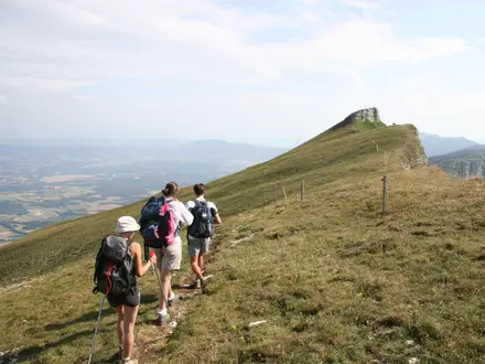
The Wainwright Coast to Coast is a 306 km (190-mile) point-to-point National Trail across northern England, from St Bees on the Irish Sea to Robin Hood's Bay on the North Sea. Most walkers take 12-15 days. It is strenuous: expect about 8,500 m of ascent, Lake District fells, boggy moorland, lowland field paths and exposed North York Moors before the final coastal cliffs. It suits experienced multi-day hikers who can handle changeable weather, long stages and remote upland navigation.
Route Overview
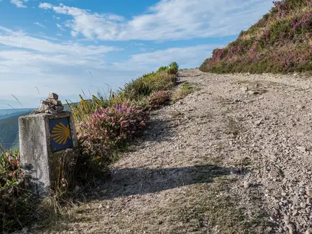
Walked traditionally west-to-east, the route begins at St Bees, crosses the Lake District via Ennerdale Bridge, Borrowdale, Grasmere, Patterdale, Kidsty Pike and Haweswater, then continues through Shap, Orton and Kirkby Stephen to Nine Standards Rigg. The Yorkshire Dales section runs by Keld, Reeth and Richmond before the flatter Vale of Mowbray and Ingleby Cross lead into the North York Moors: Blakey Ridge, Glaisdale, Egton Bridge and Grosmont, finishing at Robin Hood's Bay. It is a point-to-point walk, now waymarked as a National Trail with the acorn symbol; arrange end-to-end travel before you start. Comparing options? See the upland Beacons Way or coastal Anglesey Coastal Path.
History of the Wainwright Coast to Coast
Alfred Wainwright devised the walk and described it in his 1973 book A Coast to Coast Walk: A Pictorial Guide. He linked existing public rights of way between the Irish Sea and North Sea, and encouraged walkers to devise variations rather than follow one rigid line. The Wainwright Society became the route's Responsible Organisation in 2012. After a three-year upgrade programme, the route opened as an official England National Trail on 26 March 2026.
Notable highlights
St Bees Head (red-sandstone sea cliffs): The walk starts beside dramatic cliffs that are an RSPB reserve and the only seabird cliffs in north-west England, with kittiwakes, guillemots, razorbills and a small Atlantic puffin colony.
Helvellyn / Striding Edge (optional high-level variant): On the Grasmere-Patterdale section, experienced walkers can choose a high route over St Sunday Crag or detour towards Helvellyn and the knife-edge arête of Striding Edge. This is not the obligatory Coast to Coast line.
Kidsty Pike (780 m): The highest point actually on the walk, in the eastern Lake District above Haweswater. It gives a memorable mountain finish before the steep descent towards the reservoir.
Nine Standards Rigg (watershed cairns): A line of nine ancient stone cairns near Kirkby Stephen, marking the symbolic divide between waters flowing to the Irish Sea and North Sea. The surrounding upland can be boggy after rain.
Swaledale lead-mining landscape: The Yorkshire Dales section passes 18th- and 19th-century lead-mining remains above Gunnerside and Keld, mixed with drystone walls, field barns and riverside walking.
Robin Hood's Bay (eastern terminus): The route ends in a steep former fishing and smuggling village of red-roofed cottages and narrow alleys dropping to the North Sea, where walkers traditionally throw in their carried pebble.
Challenges to expect
Expect sustained effort rather than technical climbing: about 8,500 m of ascent, rocky Lake District fell paths, boggy moorland around Nine Standards Rigg, exposed North York Moors and some long lowland sections. The trail is now National Trail waymarked, but map and compass or GPS skills are still sensible on remote high ground. Accommodation is plentiful but can book out in mid-July to late August.
HikeList Score
The Wainwright Coast to Coast scored 86/100 on HikeList's trail-quality metrics.
See score breakdownHide breakdown
- Ideal length 88
- Balanced challenge 56
- Scenery & wildness 85
- Varied terrain 100
- Accommodation 100
- Food & support 94
- Path quality 89
- Season flexibility 89
Computed from length, challenge, scenery & wildness, terrain variety, accommodation, food & support, path quality and season flexibility.
Show more data Show less
- Mountainous
- Coastal
- Moorland
- Pastoral
- Lowland
- Woodland
- Rocky
- Gravel
- Dirt
- Grass
- Mud
- Paved
- B&Bs
- Guesthouses
- Pubs/Inns
- Hostels
- Campsites
- Family Friendly
- Dog Friendly On Leash
- Restrooms
- Potable Water Sources
- Shelters
- Public Transport Access Points
Download Our Full Guide to The Wainwright Coast to Coast FREE!
Get our comprehensive guide to this hike for free. Save it for later reading or print out at home.
Articles related to this hike
In these collections
Photos from hikers
Taken on the trail by people who've reviewed The Wainwright Coast to Coast.
The Wainwright Coast to Coast: The Complete Guide
 i
Image by ExploreMoreUK
i
Image by ExploreMoreUK The Wainwright Coast to Coast is one of England’s great point-to-point walks: a west-to-east crossing from St Bees on the Irish Sea to Robin Hood’s Bay on the North Sea. It links the Lake District, Yorkshire Dales and North York Moors in a single, demanding journey across fells, valleys, farmland and moorland.
The route begins beside the red sandstone cliffs of St Bees Head, where walkers traditionally wet their boots and pick up a pebble for the crossing. It ends in the steep lanes of Robin Hood’s Bay, with the same pebble thrown into the North Sea.
Now upgraded as the Coast to Coast Path National Trail, the line is waymarked with the acorn, but it is still a long upland walk rather than a casual ramble. The Lake District stages bring rocky fell paths and real height gain, while Nine Standards Rigg, Swaledale, the Vale of Mowbray and the North York Moors each add their own navigation, weather and endurance challenges.
Most walkers take 12–15 days, though adding time makes the longest stages and scarce overnight stops easier to manage. Fit, experienced hikers will get the most from it, especially those comfortable with British hill weather, early accommodation booking and carrying reliable mapping or GPS.
This guide covers stages, daily planning, accommodation, food, transport, terrain and the common mistakes to avoid.
Stage-by-Stage Guide
Stage 1: St Bees to Ennerdale Bridge — 22 km
The walk starts on St Bees beach before climbing onto the red-sandstone cliffs of St Bees Head. This first stage quickly changes character: sea cliffs and coastal turf give way to inland paths through Sandwith, Cleator and the western fringe of the Lake District.
Underfoot, expect a mix of cliff-top paths, field paths, tracks and lanes. The coastal section is exposed to wind, and the inland fields can be muddy after rain, but this is not yet the rocky mountain terrain that comes later.
St Bees Head is the main early landmark, with views back over the Irish Sea before the route turns east. The traditional start is to wet your boots in the sea and pick up a pebble to carry across England.
St Bees has the best start-of-day services and its own railway station on the Cumbrian Coast Line. Ennerdale Bridge is a smaller overnight stop, so accommodation and evening meals should be booked in advance rather than left to chance.
Navigation is now helped by National Trail waymarking, but the transition from coast to inland paths still requires attention at field edges and junctions. Carry enough food and water from St Bees for the day unless current services in the villages en route have been checked before travelling.
Road access is available at the start and finish, and St Bees is the key railhead for reaching the trail. Public transport from Ennerdale Bridge should be checked before travelling.
Stage 2: Ennerdale Bridge to Rosthwaite (Borrowdale) — 24 km
This is the first properly remote Lake District stage. The route follows Ennerdale Water and continues up the wild, roadless Ennerdale valley towards Black Sail before crossing high ground by Honister Pass and dropping into Borrowdale.
Terrain becomes rougher and more sustained than on Stage 1. Expect lakeshore paths, valley tracks, stony upland paths and a mountain-pass crossing, with slower going in poor weather.
Ennerdale Water, the upper Ennerdale valley, Black Sail Youth Hostel and Honister Pass are the key features. Black Sail is one of the most isolated hostels in England, but it should not be treated as a casual food stop unless arrangements have been made.
Food and water options are limited once you leave Ennerdale Bridge. Most walkers should carry a full day’s food and enough water, with any reliance on hostels or seasonal services checked before travelling.
Rosthwaite in Borrowdale is a recognised overnight stop with accommodation, but it is still a small valley settlement and beds can be limited in busy periods. Book ahead, especially if walking in mid-summer.
Navigation matters here, particularly in cloud, rain or strong wind around the higher ground. Road access is available at Honister Pass and at Rosthwaite, but public transport and taxi options should be checked before travelling.
Stage 3: Rosthwaite (Borrowdale) to Grasmere — 14 km
A shorter stage on paper, but still a Lake District crossing rather than an easy rest day. The route leaves Borrowdale and crosses into the central Lakes before descending to Grasmere.
The walking is on rocky fell paths, upland tracks and valley approaches. After wet weather, expect slippery stone, mud and slower progress on descents.
Borrowdale and Grasmere give this stage a classic Lake District feel, with enclosed valleys, open fell crossings and a village finish. Grasmere is one of the better service points on the whole route, with more accommodation than most smaller overnight stops.
Carry lunch from Rosthwaite unless current options on the day’s line have been checked. Grasmere is a good place to resupply, do laundry if available, and recover before the next Lakeland crossing.
Navigation is generally more contained than on the longest upland days, but mist can still make fell paths confusing. Do not underestimate the stage simply because it is short; rocky ground and wet conditions can make it tiring.
Road access exists at both Rosthwaite and Grasmere. Public transport options in the valleys should be checked before travelling, particularly if planning to skip or split this stage.
Stage 4: Grasmere to Patterdale — 13 km
This short but important Lake District stage crosses from Grasmere towards Grisedale Tarn and then descends towards Patterdale. It is a compact mountain day, with height gain, exposed ground and changeable conditions.
The main line is not a technical route, but the paths are upland paths: stony, steep in places and potentially slippery when wet. Grisedale Tarn is the key landmark and an obvious point where bad weather can make the day feel more serious.
Optional high-level variants such as St Sunday Crag or Helvellyn and Striding Edge are not the obligatory Coast to Coast line. They should only be considered by walkers with the right conditions, time, experience and equipment.
Grasmere is the best place to buy food before setting off. Patterdale is a popular overnight stop, but accommodation should still be booked well ahead because many walkers converge here before the Kidsty Pike stage.
Navigation requires care around high ground, especially in mist. The National Trail waymarks help, but map, compass or GPS competence remains sensible in the Lake District.
Road access is available at Grasmere and Patterdale. Public transport from Patterdale should be checked before travelling.
Stage 5: Patterdale to Shap — 26 km
This is one of the defining mountain stages of the Coast to Coast. From Patterdale the route climbs past Angle Tarn towards Kidsty Pike, the highest point on the trail at 780 m, before descending steeply to Haweswater and continuing to Shap.
Terrain is strenuous and varied: rocky fell paths, exposed high ground, a steep descent from Kidsty Pike, reservoir-side walking by Haweswater and a long onward finish. In poor visibility or strong wind, this is a serious upland day.
Angle Tarn, Kidsty Pike and Haweswater are the major landmarks. The views from the high ground can be outstanding, but the descent towards the reservoir is one of the places where tired legs and wet rock deserve respect.
There are limited opportunities for food or reliable facilities between Patterdale and Shap. Start with a full day’s food and enough water, and do not depend on untreated upland water.
Shap is an established overnight stop and a useful point after leaving the Lake District high fells. Accommodation should be booked ahead, particularly if following a fixed 13-day itinerary.
Navigation is most important on the approach to and over Kidsty Pike, and again if cloud drops onto the fells. Road access becomes easier at Shap, while public transport options should be checked before travelling.
Stage 6: Shap to Kirkby Stephen — 32 km
This is a long transitional stage from the edge of the Lake District into the limestone and Pennine country around Orton and Kirkby Stephen. It is less mountainous than the previous day, but the distance makes it demanding.
Expect a mixture of field paths, tracks, lanes, open ground and limestone-country walking. After rain, lowland fields and grassy paths can be slow and muddy, and the length of the stage leaves little margin for a late start.
Orton is the key place passed between Shap and Kirkby Stephen. The broader character changes from Lakeland fell country to a more open, rolling landscape approaching the Pennine watershed.
Food and water planning matters because the stage is long. Carry sufficient supplies from Shap unless current services in Orton and elsewhere on the line have been checked before travelling.
Kirkby Stephen is one of the main service towns on the route and a sensible place to resupply before Nine Standards Rigg. Accommodation is generally more available here than in the smaller moorland stops, but advance booking is still recommended in peak season.
Navigation is usually less complex than in the high Lakes, but there are many path and field junctions where small errors can waste time. Road access exists at Shap, Orton and Kirkby Stephen; public transport should be checked before travelling.
Stage 7: Kirkby Stephen to Keld — 19 km
This stage crosses the Pennine watershed by Nine Standards Rigg before descending towards Keld and Swaledale. It is shorter than the previous day, but can be far slower in wet conditions.
The main challenge is the peat moorland around Nine Standards Rigg. The ground can be boggy and waterlogged after rain, and route choice or official line management may vary to protect the moor; current signage and diversions should be checked before travelling.
Nine Standards Rigg is one of the symbolic high points of the whole walk, marking the divide between waters draining west and east. In clear weather it gives a strong sense of leaving the western half of the route behind.
Leave Kirkby Stephen with food for the day. Keld is a small and important overnight stop, and accommodation is thin compared with larger towns, so book well ahead.
Navigation over the moor needs care, especially in mist, snow patches, heavy rain or low cloud. Waymarks are helpful, but this is still a place to have proper mapping and not rely solely on following footprints across peat.
Road access is available at Kirkby Stephen and Keld, but public transport and taxi options should be checked before travelling. Keld’s limited accommodation makes this a stage where a backup plan is useful.
Stage 8: Keld to Reeth — 18 km
This Swaledale stage links Keld, Gunnerside and Reeth through a landscape of drystone walls, stone barns and lead-mining remains. It is less high and exposed than Nine Standards Rigg, but still has rough and muddy sections.
The route passes through the former lead-mining landscape, with Old Gang and Surrender smelt mills among the notable remains in the wider Keld–Reeth section. Depending on the chosen line, walkers may encounter higher moorland or lower valley-style walking.
Gunnerside is the main named settlement between Keld and Reeth. Swaledale views, stone field barns and mining relics are the main interest rather than a single mountain summit.
Food and water availability between Keld and Reeth should be checked before travelling, especially outside the main season. Carry lunch from Keld unless certain of services en route.
Reeth is a well-used overnight stop and has more accommodation choice than Keld, but advance booking is still wise in summer. It is also a sensible place to review weather and logistics before the approach to Richmond.
Navigation is generally more straightforward than on the peat moors, but old tracks, field paths and alternative lines can still cause confusion. Road access exists at Keld, Gunnerside and Reeth; public transport should be checked before travelling.
Stage 9: Reeth to Richmond — 17 km
This is a comparatively moderate stage from the upper Dales into Richmond, the largest town on the route. It is often used as a partial recovery day before the very long Richmond to Ingleby Cross stage.
The terrain is mainly Dales field paths, tracks, lanes and riverside or valley-edge walking around the River Swale corridor. Mud, livestock and awkward field gates can slow progress, but this is not one of the route’s most remote stages.
The day ends in Richmond, with its Norman castle keep above the River Swale and large cobbled market place. This is the best major-service stop before the Vale of Mowbray crossing.
Food and water planning is easier than on the high moor stages, but a packed lunch remains sensible unless current services have been checked. Richmond is a good place for resupply, gear replacement and accommodation choice.
Navigation is mostly about staying alert through fields, lanes and settlement edges rather than mountain route-finding. Watch for livestock in enclosed fields and follow the waymarked line carefully where paths cross farmland.
Road access is available at both Reeth and Richmond. Public transport connections should be checked before travelling, but Richmond is the most practical service hub on this part of the walk.
Stage 10: Richmond to Ingleby Cross — 37 km
This is the longest stage in the standard itinerary and one of the most logistically awkward. It crosses the flatter farmland of the Vale of Mowbray between the Yorkshire Dales and the North York Moors.
The walking is less rugged than the Lake District, but the distance is severe. Expect field paths, tracks, lanes and sections that can feel slow after rain because lowland paths may be muddy or waterlogged.
Danby Wiske is the key named place between Richmond and Ingleby Cross. This is a practical crossing stage rather than a highlight-packed mountain day, and pacing matters more than scenery.
Start early, carry enough food and water, and do not assume frequent facilities between Richmond and Ingleby Cross. Any intermediate services should be checked before travelling.
Accommodation at Ingleby Cross is limited compared with Richmond, so book well ahead. Many walkers split this stage if accommodation and transport arrangements allow; any split-point logistics should be checked before travelling.
Navigation requires concentration because the route passes through farmland, lanes and numerous junctions where waymarks can be missed. Road walking and lane sections require care, particularly in poor visibility or at busy times.
Road access is available at Richmond, Danby Wiske and Ingleby Cross. Public transport and taxi options should be checked before travelling, especially if planning to shorten the day.
Stage 11: Ingleby Cross to Blakey Ridge — 32 km
This stage climbs out of the lowlands into the North York Moors, changing the route’s character again. It is long, open and exposed, with a remote finish at Blakey Ridge.
Underfoot, expect woodland and moorland approaches, tracks, open heather moor and an old railway trackbed on the way towards Blakey Ridge. Conditions can be wet and windy on the moors, with limited shelter once committed to the high ground.
The North York Moors are the main feature of the day. The isolated Lion Inn at Blakey Ridge is the best-known landmark at the finish and one of the highest pubs in England.
Food and water should be planned carefully. Ingleby Cross and Blakey Ridge are both limited compared with larger towns, and any reliance on the Lion Inn or other services should be checked before travelling.
Accommodation at or near Blakey Ridge is thin, so this is one of the key nights to book early. If beds are unavailable, transport to off-route accommodation may be needed and should be arranged in advance.
Navigation on moorland and old trackbeds is usually less intricate than in farmland, but mist, rain and featureless heather can still make direction-finding difficult. Road access exists at Blakey Ridge, but public transport options should be checked before travelling.
Stage 12: Blakey Ridge to Glaisdale — 19 km
After the long haul to Blakey Ridge, this is a shorter North York Moors stage heading towards Glaisdale. It remains exposed at first, then gradually becomes more settled as the route moves east.
The terrain includes moorland tracks, old railway-style walking and paths descending towards villages. In wet or windy weather, the open sections can still feel serious despite the shorter distance.
Blakey Ridge provides the remote high-level start, and Glaisdale is the main finish point. The stage gives a gradual transition from open moor towards the more inhabited eastern side of the route.
Carry enough food and water from Blakey Ridge unless current services have been checked. Glaisdale has accommodation options, but it is smaller than Richmond or Grasmere, so booking ahead remains sensible.
Navigation is generally straightforward on strong tracks, but care is still needed where the route leaves open moorland and picks up village paths or lanes. Weather exposure is the main warning early in the day.
Road access exists at Blakey Ridge and Glaisdale. Public transport should be checked before travelling, particularly if using this stage as part of a section hike.
Stage 13: Glaisdale to Robin Hood's Bay — 32 km
The final stage is long and varied, passing through Glaisdale, Egton Bridge, Grosmont, Littlebeck and Hawsker before reaching Robin Hood's Bay. It is not a ceremonial stroll: the distance and repeated changes of terrain still require a full day’s effort.
Expect village paths, tracks, lanes, woodland or valley sections, and the final coastal approach. The last part brings the route to the North Sea and into the steep, red-roofed village of Robin Hood's Bay.
Egton Bridge, Grosmont, Littlebeck and Hawsker provide the main waypoints. The finish at Robin Hood's Bay is the traditional place to wet your feet in the sea and throw in the pebble carried from St Bees.
Food and water planning should reflect the long distance. Do not assume every village has the service needed at the time of arrival; opening times and current facilities should be checked before travelling.
Robin Hood's Bay has accommodation, but many walkers finish there and beds can be in demand. Book the final night early if staying after the walk.
Navigation requires attention through villages, lanes and the final coastal section, where it is easy to relax too soon. The route is waymarked, but tiredness on the last day can lead to missed turns.
Robin Hood's Bay has no railway station. Onward travel is by bus to Whitby or Scarborough, or by taxi; bus times and connections should be checked before travelling, especially if leaving the same day.
Recommended Itinerary
The 13-day itinerary below is a practical standard schedule using the main overnight hubs on the route. It keeps the two short Lake District stages between Rosthwaite, Grasmere and Patterdale, which gives useful recovery time and a better weather margin before the harder crossing to Shap.
Distances are approximate. Check official mapping before booking, especially where live diversions, high-level variants or accommodation availability may change the day length.
Standard itinerary: 13 walking days
| Day | From | To | Approx. distance | Why this stage makes sense | Services/accommodation notes |
|---|---|---|---|---|---|
| 1 | St Bees | Ennerdale Bridge | 22 km | A full first day that clears the coast at St Bees Head and gets the walk properly inland without overreaching on day one. | St Bees has its own railway station, so arriving the previous day is often simpler than starting after a long journey. Ennerdale Bridge is a small overnight stop, so accommodation should be booked ahead. |
| 2 | Ennerdale Bridge | Rosthwaite (Borrowdale) | 24 km | This is the first serious Lake District day, following Ennerdale Water and the wild Ennerdale valley before crossing by Black Sail and Honister Pass into Borrowdale. | Black Sail Youth Hostel is a notable remote option in Ennerdale for walkers splitting the stage, but capacity is limited. Rosthwaite is the practical end point in Borrowdale. |
| 3 | Rosthwaite (Borrowdale) | Grasmere | 14 km | A deliberately shorter day after two harder opening stages. It gives time to handle rough Lakeland ground steadily and arrive in Grasmere without pushing into a late finish. | Grasmere has plentiful accommodation compared with the smaller valley stops, but it is popular in season and should still be booked early. |
| 4 | Grasmere | Patterdale | 13 km | Another short but upland stage, crossing by Grisedale Tarn to Patterdale. Keeping this day short is sensible because weather and visibility matter on the fells. | Patterdale is a key Lake District overnight hub with more options than the remoter stops. Optional high-level variants such as St Sunday Crag or Helvellyn/Striding Edge make this a much more serious day and are not the standard Coast to Coast line. |
| 5 | Patterdale | Shap | 26 km | One of the route’s biggest mountain days, crossing past Angle Tarn to Kidsty Pike, the highest point on the Coast to Coast, before the steep descent to Haweswater and the onward walk to Shap. | Start early and avoid treating the distance as the only difficulty: ascent, rocky paths and exposed ground make this a demanding stage. Shap is the natural overnight stop before the Pennine transition. |
| 6 | Shap | Kirkby Stephen | 32 km | A long cross-country stage through the limestone and Pennine edge country, passing Orton before reaching Kirkby Stephen. | This is one of the longer standard days. Kirkby Stephen has good walker infrastructure and is a useful place to resupply before Nine Standards Rigg. |
| 7 | Kirkby Stephen | Keld | 19 km | The shorter distance is well placed because the route climbs to Nine Standards Rigg, where the surrounding peat can be boggy after rain and navigation still deserves attention. | Keld is one of the thinner accommodation points on the route. Book well ahead, especially from mid-July to late August. |
| 8 | Keld | Reeth | 18 km | A manageable Swaledale stage through lead-mining country and drystone-wall landscapes, with Gunnerside lying on the route. | Reeth is a practical Dales overnight hub with more accommodation than Keld. It is a good point to pause, dry kit and reset before Richmond. |
| 9 | Reeth | Richmond | 17 km | A shorter day into the largest town on the route, useful before the very long crossing of the Vale of Mowbray. | Richmond has plentiful accommodation and services compared with most route stops. It is one of the best places for laundry, food resupply and any gear adjustments. |
| 10 | Richmond | Ingleby Cross | 37 km | The longest standard stage, crossing lower, flatter country through the Vale of Mowbray. The mileage is the main challenge, rather than mountain terrain. | Consider splitting this day if accommodation can be arranged around Danby Wiske or another suitable point. Ingleby Cross is a thin accommodation stop, so do not leave booking late. |
| 11 | Ingleby Cross | Blakey Ridge | 32 km | A long North York Moors stage with sustained open moorland walking, finishing at the isolated high point of Blakey Ridge. | Blakey Ridge has very limited accommodation, with the Lion Inn the key landmark stop on the route. Book early and confirm any baggage-transfer coverage before relying on it. |
| 12 | Blakey Ridge | Glaisdale | 19 km | A shorter day after two big mileage stages, following the moorland section eastwards before dropping towards Glaisdale. | Glaisdale is a more forgiving overnight than Blakey Ridge, but accommodation should still be reserved ahead in the main walking season. |
| 13 | Glaisdale | Robin Hood’s Bay | 32 km | A long final day through Egton Bridge, Grosmont, Littlebeck and Hawsker before the coast and the finish at Robin Hood’s Bay. | Robin Hood’s Bay has no railway station. Plan onward travel before starting the walk: buses run to Whitby or Scarborough, or a taxi can be arranged. |
Slower variant: 15+ days
A slower itinerary suits walkers who want more time in the Lake District, prefer shorter daily distances, are carrying camping gear, or want extra margin for bad weather. It is also the better choice for anyone unsure about consecutive 30 km-plus days.
The most useful ways to slow the route down are:
- Add a rest or half-rest day at Grasmere, Patterdale, Kirkby Stephen, Reeth or Richmond, where services are better than at the smaller stops.
- Split Shap to Kirkby Stephen if accommodation can be arranged around Orton. This should be checked before travelling.
- Split Richmond to Ingleby Cross, commonly the toughest lowland mileage day, if accommodation or transport works around Danby Wiske. This should be checked before travelling.
- Split Glaisdale to Robin Hood’s Bay by using one of the route villages such as Egton Bridge, Grosmont, Littlebeck or Hawsker, but only once accommodation and onward logistics are secured.
- Treat Keld, Ingleby Cross and Blakey Ridge as priority bookings, because these are among the thinner accommodation points.
Faster variant: 12 days
A 12-day schedule is realistic only for strong, efficient walkers who are comfortable with several long days in succession and have all accommodation fixed in advance. The simplest way to reduce the standard plan by one day is to combine the two short central Lake District stages into a single Rosthwaite to Patterdale day of roughly 27 km, then continue with the remaining stages as listed.
That faster option removes a valuable weather buffer in the Lake District. It should not be combined with optional high-level variants unless conditions, fitness and navigation are all suitable.
Avoid making the itinerary faster by relying on scarce or isolated stops without bookings. Keld, Ingleby Cross and Blakey Ridge in particular need to be planned before the walk begins.
Planning the Route
How many days to allow
Most walkers should plan the Coast to Coast as a 13 to 15-day walk rather than trying to force it into the fastest classic schedule. A 12-day itinerary is possible for strong, experienced walkers, but it leaves little margin for weather, tired legs, accommodation availability or the long lowland and moorland stages in the second half.
A 13-day schedule follows the practical accommodation hubs well, but it still includes several demanding days: Patterdale to Shap, Shap to Kirkby Stephen, Richmond to Ingleby Cross, Ingleby Cross to Blakey Ridge and Glaisdale to Robin Hood’s Bay all need careful timing. Adding one or two extra days is often the difference between a hard completion and an enjoyable crossing.
A slower 15+ day plan is especially sensible if you want shorter days through the Lake District, more time in Swaledale, or a rest day in one of the larger service centres such as Grasmere, Kirkby Stephen, Reeth, Richmond or Glaisdale.
Let accommodation shape the itinerary
This route is not planned purely from a map. Daily stages are strongly shaped by where beds, campsites and food are available, and some overnight stops have very limited capacity.
Accommodation is generally easier to arrange in the larger towns and villages, including Grasmere, Patterdale, Kirkby Stephen, Reeth and Richmond. It becomes much tighter at smaller or more isolated stops such as Keld, Ingleby Cross and Blakey Ridge, where booking well ahead is important, especially from mid-July to late August.
Do not assume that a long day can simply be shortened at the last minute. On some sections there may be few realistic overnight options between the established hubs, so a missed booking can affect the next two or three days of the walk.
A practical planning order is:
- Decide the total number of walking days.
- Secure scarce overnight stops first, particularly Keld, Ingleby Cross and Blakey Ridge.
- Build the rest of the itinerary around those fixed points.
- Book transport to St Bees and away from Robin Hood’s Bay.
- Check the official National Trail site for current route updates and diversions before setting off.
Fast, standard or relaxed itineraries
| Approach | Best for | Planning implications |
|---|---|---|
| 12 days | Very fit walkers used to long consecutive days | Less flexibility; long stages need early starts and reliable accommodation bookings. |
| 13 days | Strong walkers wanting a practical through-hike | Fits the main overnight hubs, but still includes several 30 km+ days. |
| 14–15 days | Most independent walkers | Gives more margin for weather, navigation, tiredness and slower terrain. |
| 15+ days | Walkers wanting shorter stages or rest days | More comfortable, but requires careful booking where accommodation is sparse. |
The Coast to Coast rewards a measured pace. The Lake District stages involve rocky fell paths and steep ground, while the later stages include long stretches of farmland, moorland and lanes where fatigue can build despite easier gradients.
Shortening, extending and alternatives
Shortening the route is possible only by missing sections, as this is a point-to-point crossing rather than a route with simple escape loops. If time is limited, it is usually better to plan a defined section than to start the full trail with an unrealistic schedule.
Extending the walk is straightforward in planning terms: add rest days or split long stages where accommodation allows. The main constraint is not the walking line itself but the availability of beds and services between established stopping places.
There are optional higher-level variants, particularly in the Lake District and around Swaledale, but these should be treated as choices rather than the default route. Helvellyn, Striding Edge and St Sunday Crag are optional high-level alternatives on the Grasmere to Patterdale section, not the main Coast to Coast line. Higher variants increase ascent, exposure and weather risk.
Section hiking
Section hiking is practical, but it needs more transport planning than a circular or rail-linked route. St Bees is straightforward as a starting point because it has its own railway station on the Cumbrian Coast Line, with connections via Carlisle.
Robin Hood’s Bay has no railway station, so the eastern end requires a bus or taxi connection to Whitby or Scarborough. End-to-end travel is long, and return travel should be planned before the walk begins.
For intermediate section breaks, the most practical places are likely to be larger settlements on the route, such as Grasmere, Patterdale, Kirkby Stephen, Reeth, Richmond and Glaisdale, but onward public transport varies by place and season. This should be checked before travelling.
Navigation and route updates
The Coast to Coast is now a National Trail and carries the acorn waymark, but that does not remove the need for proper navigation. The Lake District fells, the area around Nine Standards Rigg and the open North York Moors can all be difficult in poor visibility.
Carry mapping or a reliable GPS route, and know how to use it. Relevant OS Explorer mapping includes OL4, OL5, OL7, OL19, OL26, OL27 and OL30, or a dedicated Coast to Coast guide covering the full National Trail line.
Because the route was recently upgraded, check current signage, temporary diversions and live trail notices on the official National Trail site before relying on waymarks alone.
Food, water and daily supplies
Do not plan the Coast to Coast as if food is available at every overnight stop or halfway point. Larger places such as Grasmere, Patterdale, Kirkby Stephen, Reeth and Richmond are better planning anchors, while smaller stops and isolated moorland sections require more caution.
Carry lunch and spare food each day, especially on the longer stages into Shap, Kirkby Stephen, Ingleby Cross, Blakey Ridge and Robin Hood’s Bay. Check evening meal and breakfast arrangements when booking accommodation, particularly in smaller villages and isolated locations.
Water should be topped up whenever reliable facilities are available. Do not rely on upland streams, tarns or moorland water as a routine drinking source without suitable treatment.
Weather and timing
Weather planning matters as much as mileage. The route crosses exposed high ground in the Lake District, including Kidsty Pike above Haweswater, and the moorland around Nine Standards Rigg can be boggy after rain. The North York Moors section also has long exposed stretches where wind, rain and low cloud can slow progress.
Spring, summer and autumn are the normal walking seasons, but conditions can still be wet, cold or windy on higher ground. A fixed accommodation schedule means there may be pressure to continue in poor weather, so allow realistic daily timings and avoid building an itinerary with no slack.
The key planning priorities
For this route, the main planning risks are not technical climbing or permits. They are accommodation availability, long stage lengths, exposed upland weather, navigation in poor visibility and transport at the start and finish.
Book early, carry proper navigation, check current National Trail updates, and build an itinerary that matches real walking speed rather than optimistic map distances. That is the difference between simply reaching Robin Hood’s Bay and completing the Coast to Coast in good order.
Towns, Villages and Overnight Stops
Accommodation planning is one of the main practical challenges on the Coast to Coast. The larger service centres are well spaced in some sections, but several stage ends are small villages or isolated moorland stops where beds can sell out quickly, especially from mid-July to late August.
Book the constrained stops first: Keld, Ingleby Cross and Blakey Ridge are the key pressure points. Then fill in the Lake District and Swaledale nights around them.
| Place | Typical role on the walk | Accommodation / services note |
|---|---|---|
| St Bees | Start village | Has its own railway station; sensible place to stay before the first walking day. |
| Ennerdale Bridge | First overnight stop | Small stage-end village; book ahead. |
| Black Sail | Remote hostel option | One of England’s most isolated hostels; useful only if your itinerary is built around it. |
| Rosthwaite | Borrowdale overnight stop | Established Lake District stage end; availability should be checked early. |
| Grasmere | Major Lake District hub | Plentiful accommodation compared with smaller stops. |
| Patterdale | Major Lake District hub | Plentiful accommodation compared with smaller stops. |
| Shap | Long-stage overnight stop | Important stop after the Kidsty Pike and Haweswater day. |
| Kirkby Stephen | Major service hub | Plentiful accommodation; good place to reset before Nine Standards Rigg. |
| Keld | Small Swaledale stop | Thin accommodation; book well ahead. |
| Reeth | Major Swaledale hub | Plentiful accommodation compared with smaller villages. |
| Richmond | Largest town on the route | Best major service stop before the long lowland crossing. |
| Ingleby Cross | Small stage-end stop | Thin accommodation; book well ahead. |
| Blakey Ridge | Isolated moorland stop | Very limited options; plan this night early. |
| Glaisdale | North York Moors stop | Useful final-section overnight before the coast. |
| Robin Hood’s Bay | Finish village | No railway; onward travel is by bus to Whitby or Scarborough, or by taxi. |
St Bees
St Bees is the western trailhead on the Cumbrian coast, with the walk beginning from the beach before heading over St Bees Head. Staying here the night before the walk avoids a rushed start and gives time to deal with the traditional boot-dip and pebble-carrying ritual before setting off.
The village has its own station on the Cumbrian Coast Line, with access via Carlisle from the West Coast Main Line. Accommodation should still be booked ahead in the main walking season, as many Coast to Coast itineraries begin here on similar dates.
Food and last-minute supplies should not be left to chance. Opening times, pub food availability and shop provision should be checked before travelling.
Sandwith and Cleator
Sandwith and Cleator come early on the first walking day between St Bees and Ennerdale Bridge. They are useful route markers rather than the main overnight targets for most walkers.
Do not assume either will solve a missed breakfast, water or resupply problem without checking current opening times. The practical aim on this section is usually to reach Ennerdale Bridge with enough time to eat and rest before the more committing Lake District days begin.
Ennerdale Bridge
Ennerdale Bridge is the standard first overnight stop after the opening day from St Bees. It sits before the route enters the wilder Ennerdale section, so it is a logical place to regroup before the longer valley and fell stages ahead.
Accommodation is more limited than in the larger Lake District villages, so advance booking is sensible. Food and pub arrangements should be checked when booking your bed, particularly if arriving late after the first 22 km stage.
Transport options are not a planning strength here. If starting, stopping or rejoining at Ennerdale Bridge, local taxi or bus possibilities should be checked before travelling.
Ennerdale Water
Ennerdale Water is not a village stop, but it is an important planning point on the second day. The route follows the lakeshore and then continues up the roadless Ennerdale valley towards Black Sail and Honister Pass.
Treat this as a committing walking section rather than a place to improvise accommodation or supplies. Carry the food, water and foul-weather kit needed for a long upland day.
Black Sail
Black Sail Youth Hostel sits deep in Ennerdale and is one of the most isolated hostels in England. It can be used to create a shorter or more unusual Lake District itinerary, but it needs deliberate planning rather than being treated as a casual fallback.
Beds are limited and the location is remote, so availability, access arrangements and food provision should be checked before booking the rest of the itinerary around it. It is particularly relevant for walkers wanting to split the Ennerdale Bridge to Rosthwaite day.
Honister Pass
Honister Pass is a high-level crossing point before the descent into Borrowdale. It is not normally treated as a main Coast to Coast overnight base in the standard itinerary.
Use it as a timing and weather checkpoint. If conditions are poor, make sure there is enough daylight and energy left for the onward descent to Rosthwaite or your booked Borrowdale accommodation.
Rosthwaite and Borrowdale
Rosthwaite is the usual overnight stop in Borrowdale after the Ennerdale and Honister section. It is a well-placed Lake District stage end before the shorter crossing to Grasmere.
Accommodation exists in and around Borrowdale, but it should still be booked early because Lake District beds are in demand beyond the Coast to Coast season. Evening meals, packed lunches and any local transport should be arranged directly with accommodation providers or checked before travelling.
Grasmere
Grasmere is one of the major accommodation hubs on the route and a common place to pause after the first harder Lake District days. Compared with the smaller villages, it has plentiful accommodation options, including the kind of B&Bs, guesthouses, pubs, inns, hostels and camping options found along the broader route.
It is a sensible resupply and recovery stop before the Grisedale Tarn and Patterdale stage. Because Grasmere is also a very popular Lake District village in its own right, book well ahead in summer and do not rely on last-minute availability.
Grisedale Tarn
Grisedale Tarn is a mountain waypoint between Grasmere and Patterdale, not an overnight village stop for the standard itinerary. It marks the exposed upland character of this stage and is a useful point for deciding how conditions are developing.
The higher variants towards St Sunday Crag or Helvellyn and Striding Edge are optional, not the obligatory Coast to Coast line. In poor weather, keep the day conservative and prioritise reaching booked accommodation in Patterdale.
Patterdale
Patterdale is a major Lake District overnight hub and one of the better-served stops on the western half of the route. It is the last substantial village before the long, strenuous stage over Angle Tarn, Kidsty Pike and down to Haweswater, then onward to Shap.
Accommodation is relatively plentiful compared with smaller stops, but demand is high in the walking season. This is a good place to confirm breakfast, packed lunch and any baggage-transfer arrangements before the longest and highest Lake District day.
Angle Tarn, Kidsty Pike and Haweswater
Angle Tarn, Kidsty Pike and Haweswater are key route features rather than accommodation bases. Kidsty Pike is the highest point on the Coast to Coast line at 780 m, followed by a steep descent towards Haweswater.
There are no town services to rely on through this mountain and reservoir section. Leave Patterdale with a full day’s food, waterproofs, navigation and enough time to complete the onward walk to Shap.
Shap
Shap is the standard overnight stop after the Patterdale to Shap stage. Its main value is practical: it comes after a demanding mountain day and before the long 32 km crossing towards Kirkby Stephen.
Accommodation should be arranged in advance, especially if walking a fixed schedule. Food and shop opening times should be checked before arrival, as the next day is long and exposed in places.
Orton
Orton lies between Shap and Kirkby Stephen on the limestone and Pennine approach section. It can be useful for walkers splitting the long Shap to Kirkby Stephen stage, depending on the exact itinerary and available accommodation.
Do not assume a same-day bed or full resupply here. If using Orton as an overnight or lunch stop, check accommodation, food and onward logistics before committing to the split.
Kirkby Stephen
Kirkby Stephen is one of the most important service stops on the route. It comes before the climb to Nine Standards Rigg and the crossing of the Pennine watershed towards Keld.
Accommodation is plentiful compared with the smaller upland villages, making it a good place for a restock, laundry or recovery night if the schedule allows. It is also a sensible point to re-check weather and ground conditions before the boggier moorland around Nine Standards Rigg.
Nine Standards Rigg
Nine Standards Rigg is a high moorland landmark rather than a settlement. The surrounding peat can be very boggy after rain, so it affects accommodation planning indirectly: progress may be slower than the distance suggests.
Start the Kirkby Stephen to Keld day with enough food, water and daylight. If weather is poor, navigation remains important even with National Trail waymarking.
Keld
Keld is a small but strategically important overnight stop at the head of Swaledale. It sits after the Nine Standards Rigg crossing and before the Swaledale route through Gunnerside and Reeth.
Accommodation is thin, so this is one of the first nights to book on any Coast to Coast itinerary. If no bed is available, the surrounding stage plan may need adjusting rather than hoping for a simple late alternative.
Food provision, packed lunches and evening meals should be confirmed when booking. Keld is not a place to arrive assuming multiple options will be available.
Gunnerside and Swaledale
Gunnerside sits on the Swaledale section between Keld and Reeth. This part of the walk passes through the lead-mining landscape, with remains such as Old Gang and Surrender smelt mills in the wider area of the route.
Most standard itineraries continue to Reeth for the night, but Gunnerside can matter for shorter-stage planning. Accommodation, food and transport options should be checked before building an itinerary around it.
Reeth
Reeth is a major Swaledale overnight hub and a practical stop before the shorter walk to Richmond. Accommodation is relatively plentiful compared with Keld and the smaller dale villages.
It is a good place to recover after the Pennine and Swaledale stages, and to prepare for the transition from hill country towards the lower farmland beyond Richmond. Book ahead in summer, particularly if a rest day or shorter day is planned here.
Richmond
Richmond is the largest town on the Coast to Coast and the most important service centre before the long lowland crossing towards Ingleby Cross. It has a Norman castle keep above the River Swale and a large cobbled market place, but for walkers its main value is practical.
Use Richmond for accommodation, food, resupply and any schedule adjustments before the 37 km stage to Ingleby Cross. Because the following day is one of the longest standard stages, it is worth leaving Richmond with food and water plans settled rather than relying on uncertain intermediate services.
Transport from Richmond for section-hiking or itinerary changes should be checked before travelling. Do not assume that onward links will match walking-stage timings.
Danby Wiske
Danby Wiske lies on the long Richmond to Ingleby Cross section across the flatter Vale of Mowbray. It is an important psychological and logistical point because this stage is long, lower-level and very different from the upland sections.
Some walkers may look to use Danby Wiske to split the day, but accommodation and food availability must be checked before committing to that plan. If walking through in one day, carry enough supplies from Richmond to avoid depending on uncertain opening times.
Ingleby Cross
Ingleby Cross is the usual overnight stop after the long stage from Richmond. It is a key staging point before the route climbs into the North York Moors.
Accommodation is thin, so book this night early. If beds are full, the knock-on effect can be significant because the previous and following stages are both long by standard Coast to Coast schedules.
Food and breakfast arrangements should be confirmed directly with the accommodation. The next stage to Blakey Ridge is around 32 km, so a packed lunch or reliable food plan is important.
Blakey Ridge
Blakey Ridge is one of the most isolated overnight points on the Coast to Coast. It sits high on the North York Moors, with the route using an old railway trackbed across open heather moorland.
The Lion Inn is the key landmark here and is one of the highest pubs in England. Accommodation options are very limited, so this is another night to secure well ahead of the trip.
Because Blakey Ridge is exposed and remote, do not treat it as a flexible arrival point. Check meal arrangements, weather, and any baggage-transfer coverage before relying on this stop.
Glaisdale
Glaisdale is a useful overnight stop after Blakey Ridge and before the final push towards Robin Hood’s Bay. It sits in the North York Moors section as the route begins to move from open moorland towards the eastern villages and coast.
Accommodation should still be booked in advance, especially if using the 13-day schedule with a final 32 km day to Robin Hood’s Bay. Food, packed lunches and local transport options should be checked before travelling.
Egton Bridge and Grosmont
Egton Bridge and Grosmont are passed on the final approach towards the coast. They are useful places for pacing the last section, particularly if the final day from Glaisdale to Robin Hood’s Bay feels too long.
Accommodation, food and transport details should be checked before building either village into a shortened itinerary. Do not rely on them as unplanned bail-out points without current information.
Littlebeck and Hawsker
Littlebeck and Hawsker come late in the final stage before Robin Hood’s Bay. They are mainly useful as progress markers on the way to the North Sea finish.
If splitting the final stage, check accommodation and food options before committing. Most walkers will already have a bed booked either at Robin Hood’s Bay or onward transport arranged for the same day.
Robin Hood’s Bay
Robin Hood’s Bay is the eastern terminus of the Coast to Coast, where walkers traditionally wet their feet in the North Sea and throw in the pebble carried from St Bees. The village is steep and compact, so allow time to reach accommodation or onward transport after finishing.
There is no railway station at Robin Hood’s Bay. Onward travel is by frequent bus, including Arriva X93 / Coastliner services, to Whitby for the Esk Valley Line or to Scarborough for TransPennine Express services towards York and the East Coast Main Line, or by taxi.
End-to-end return travel is long and should be planned before starting the walk. Bus and train times should be checked before travelling, especially if finishing late in the day.
Getting to the Start
By train
St Bees has its own railway station on the Cumbrian Coast Line, making rail the most practical way to reach the start without creating a complicated end-to-end car shuttle.
Most long-distance rail journeys route via Carlisle, where you change from the West Coast Main Line onto the Cumbrian Coast Line towards St Bees. Carlisle has main-line connections from London Euston, Manchester, Glasgow and Edinburgh.
Allow generous connection time at Carlisle, especially if arriving the evening before the walk. Cumbrian Coast Line services are less frequent than main-line trains, and missed connections can leave a long wait. Current train times and engineering works should be checked before travelling.
From St Bees station, plan enough time to reach St Bees beach, where the Coast to Coast traditionally starts beside the red-sandstone cliffs of St Bees Head. Many walkers stay overnight in St Bees and begin fresh the next morning rather than trying to combine a long inbound rail journey with the first stage to Ennerdale Bridge.
By bus
Bus is not usually the simplest way to reach St Bees for the start of the Coast to Coast. The railway gives the clearest public-transport access to the village.
If using local buses for part of the journey, treat them as a backup or final-link option rather than the core plan. Rural services can be limited, especially on Sundays, bank holidays and outside the summer season. This should be checked before travelling.
For late arrivals or awkward connections, a pre-booked taxi from a rail point on the Cumbrian Coast Line or from Carlisle may be more reliable than waiting for onward local transport. Agree the fare in advance where possible.
By car
Driving to St Bees is straightforward for drop-off, but less convenient if leaving a vehicle for the full walk. This is a point-to-point trail ending at Robin Hood’s Bay, which has no railway station, so getting back to St Bees after finishing is time-consuming unless transport has been arranged in advance.
Do not assume that long-stay parking is available or suitable in St Bees. If planning to leave a car, check current parking rules, security, payment arrangements and any time limits before travelling. Accommodation providers may be able to advise, but this should be checked before booking.
For many walkers, the cleaner logistics are to travel to St Bees by train, walk east, then leave Robin Hood’s Bay by bus to Whitby or Scarborough for onward rail connections.
From the nearest airport
There is no airport at St Bees. The practical approach is to fly into a city with onward rail access to the West Coast Main Line, travel to Carlisle, then change for St Bees on the Cumbrian Coast Line.
Manchester, Glasgow and Edinburgh all sit on the wider rail approach described above, but airport-to-station transfers and through-ticket options vary. This should be checked before travelling, particularly if arriving late in the day.
For international arrivals into London, the rail route starts from London Euston to Carlisle, followed by the Cumbrian Coast Line to St Bees. Build in contingency time if flying and taking the train on the same day.
Where to stay before starting
The most convenient pre-walk overnight is St Bees itself. Staying in the village removes pressure from the first morning, gives time to reach the beach, and avoids starting the 22 km first stage to Ennerdale Bridge after a long journey.
Accommodation in St Bees should be booked ahead in the main walking season, especially from mid-July to late August. If St Bees is full, an alternative base somewhere on the Cumbrian Coast Line can work, but only if the morning train times allow an early, reliable start. This should be checked before travelling.
Try to arrive with food, fuel and any last equipment sorted before the first walking day. The opening stage leaves the coast and heads inland towards Ennerdale Bridge, so relying on last-minute morning errands can make the start unnecessarily tight.
Getting Home from the Finish
Robin Hood's Bay has no railway station, so the final leg away from the Coast to Coast is by bus or taxi. Return travel can take time, especially if you are heading back towards St Bees or connecting with long-distance trains, so plan the journey before starting the walk rather than working it out at the finish.
By train
The practical railheads for Robin Hood's Bay are Whitby and Scarborough, both reached first by bus or taxi.
| Railhead | How to reach it from Robin Hood's Bay | Best for |
|---|---|---|
| Whitby | Bus or taxi from Robin Hood's Bay | The Esk Valley Line |
| Scarborough | Bus or taxi from Robin Hood's Bay | TransPennine Express services to York, with onward links to the East Coast Main Line |
For many long-distance journeys, Scarborough is the more useful rail connection because it links through to York and the East Coast Main Line. Whitby is closer as a local rail option, but onward journey times and connections can be less straightforward. Train and bus times should be checked before travelling, particularly if finishing late in the afternoon.
By bus
Arriva X93 / Coastliner services link Robin Hood's Bay with Whitby and Scarborough. These are the key public-transport connections from the finish and are the usual first step for walkers leaving the village without a taxi.
Although the bus connection is described as frequent, exact times, evening services and seasonal changes are timetable-dependent. If the final stage from Glaisdale to Robin Hood's Bay is walked as one long day, do not assume there will be a convenient late bus without checking the current timetable.
By car/taxi
A taxi is the simplest option if you finish late, have luggage to collect, or need a reliable connection to a train. Taxis can also be useful for reaching Whitby or Scarborough when bus times do not line up with onward rail travel.
Because this is a point-to-point crossing from St Bees to Robin Hood's Bay, using a private car needs thought. Leaving a car at the finish means arranging transport to the start before the walk; leaving it at the start means a long return journey after finishing. For most independent walkers, public transport or a pre-booked taxi connection from Robin Hood's Bay is more practical than trying to shuttle a car at the end.
From the nearest airport
Robin Hood's Bay is not an airport-friendly finish in the sense of having a nearby direct airport transfer. The practical route is to travel first by bus or taxi to Scarborough or Whitby, then continue by rail towards the relevant mainline connection.
For flights after the walk, allow generous time and avoid booking a tight same-day departure unless the bus, rail and airport connections have all been checked in advance. Specific airport choice and transfer times should be checked before travelling.
Where to stay at the finish
Staying overnight at or near Robin Hood's Bay is often the most relaxed way to finish the Coast to Coast, especially after the long final stage from Glaisdale. It also gives more flexibility if the weather slows progress or if the traditional finish at the North Sea takes longer than expected.
If accommodation in Robin Hood's Bay is full, the onward bus/taxi links to Whitby and Scarborough give alternative places to aim for after finishing. As with the rest of the route, book ahead in the main walking season rather than relying on finding a room on arrival.
Which Direction Should You Walk?
Standard direction: St Bees to Robin Hood’s Bay
The Coast to Coast is traditionally walked west to east, from St Bees on the Irish Sea to Robin Hood’s Bay on the North Sea. This is the classic Wainwright direction: boots in the sea at St Bees, a pebble carried across England, then feet wetted again and the pebble thrown into the sea at Robin Hood’s Bay.
It is also the direction most itineraries and accommodation plans are built around. The usual sequence of overnight stops — Ennerdale Bridge, Rosthwaite, Grasmere, Patterdale, Shap, Kirkby Stephen, Keld, Reeth, Richmond, Ingleby Cross, Blakey Ridge and Glaisdale — works naturally west to east, though scarce accommodation at places such as Keld, Ingleby Cross and Blakey Ridge still needs early booking.
The main practical downside is that the Lake District comes almost immediately. Within the first few days, the route tackles rough fell paths, passes, exposed high ground and the crossing to Kidsty Pike, the highest point on the Coast to Coast line. Fit walkers often prefer this because the hardest mountain terrain is tackled while legs are fresh; less-conditioned walkers may find the opening week abrupt.
Reverse direction: Robin Hood’s Bay to St Bees
Walking east to west is entirely possible, especially now the route is a waymarked National Trail, but it is less traditional. It reverses the emotional shape of the walk: you leave the North Sea coast at Robin Hood’s Bay and finish at St Bees, rather than ending in the steep coastal village that most walkers associate with the Coast to Coast finale.
The reverse direction gives a gentler scenic build-up in one sense. The North York Moors, Vale of Mowbray and Swaledale come before the major Lake District fell crossings, so the biggest mountain days arrive towards the end rather than the start. That can be appealing if you want the Lake District as the climax, but it also means tackling the roughest ground after many days of walking.
Some climbs also feel harder in reverse. The standard west-to-east line descends steeply from Kidsty Pike towards Haweswater; in reverse, that becomes a steep climb away from Haweswater to reach the high ground. Across the whole route, however, there is no easy direction: the total ascent, long stages, boggy sections around Nine Standards Rigg and exposed moorland all have to be dealt with either way.
Transport and logistics
St Bees is the easier trailhead by rail because it has its own station on the Cumbrian Coast Line, with connections via Carlisle. Robin Hood’s Bay has no railway, so access or onward travel involves bus services to Whitby or Scarborough, or a taxi.
That means west to east gives a simple rail journey to the start, followed by a bus or taxi connection at the finish. East to west reverses that: the more awkward bus/taxi connection comes before the walk, while the finish at St Bees has a railway station. Neither direction removes the need to plan end-to-end travel carefully.
Scenery and motivation
West to east gives the most established progression: Irish Sea cliffs, the Lake District fells, limestone and Pennine watershed country, Swaledale, the Vale of Mowbray, the North York Moors and finally the North Sea coast. The final approach to Robin Hood’s Bay has strong psychological pull because it is the traditional end-point and a clear coastal finish.
East to west saves the Lake District for last, which some walkers may prefer scenically. The trade-off is that the final days are tougher underfoot and more mountainous, rather than easing towards the sea.
Recommendation
For most walkers, St Bees to Robin Hood’s Bay is the better choice. It is the traditional direction, fits the common accommodation flow, starts at a rail-served trailhead, and gives the strongest sense of progression towards the North Sea finish.
Choose the reverse only if finishing at St Bees station is more convenient, if accommodation availability works better that way, or if you specifically want the Lake District as the final challenge. Otherwise, plan west to east and book the scarce overnight stops well ahead.
Accommodation Along the Route
The Coast to Coast works well as an inn-to-inn walk, but it is not a route to leave to chance. Accommodation is a mix of B&Bs, guesthouses, pubs and inns, hostels — including YHA options and the remote Black Sail hut in Ennerdale — plus campsites, but availability is uneven.
The strongest overnight bases are the larger route towns and villages: Grasmere, Patterdale, Kirkby Stephen, Reeth and Richmond. The pinch-points are the smaller or more isolated stops, especially Keld, Ingleby Cross and Blakey Ridge, where accommodation is thin and should be booked well ahead.
Mid-July to late August is the key pressure period. For a continuous crossing, book every night before committing to trains, baggage transfer or a fixed start date.
Main overnight stops and accommodation pressure
Accommodation level is a planning guide: Good means one of the stronger overnight bases on the route; Limited means book early and have a backup plan; None means it should be treated as walking terrain rather than an overnight hub.
| Place | Accommodation level | Best for | Notes |
|---|---|---|---|
| St Bees | Limited | Start night before walking | Useful for an early start from the beach. St Bees has a railway station, so arrival by train is straightforward compared with the finish. |
| Ennerdale Bridge | Limited | First-night stop after St Bees | A small overnight base at the end of the first stage. Book rather than relying on late availability. |
| Ennerdale Water / Black Sail | Limited | Hostelling and a wilder Lake District night | Black Sail is a remote Youth Hostel in upper Ennerdale. Treat it as a pre-booked plan, not as a fallback if Ennerdale Bridge is full. |
| Rosthwaite, Borrowdale | Limited | Breaking the Lake District section | A practical overnight stop before the short crossing to Grasmere. This should be checked before travelling. |
| Grasmere | Good | Strong Lake District base, rest or resupply night | One of the better accommodation choices on the route, but also a popular village, so summer availability can still tighten. |
| Patterdale | Good | Pre-Kidsty Pike overnight stop | A key stop before the long Patterdale to Shap stage over Angle Tarn, Kidsty Pike and Haweswater. |
| Shap | Limited | End of the Kidsty Pike / Haweswater stage | Important because the previous stage is long and committing. Have this night secured before leaving Patterdale. |
| Orton | Limited | Splitting the long Shap to Kirkby Stephen section | Useful as a planning point if shortening the 32 km Shap to Kirkby Stephen day. Accommodation availability should be checked before travelling. |
| Kirkby Stephen | Good | Restock, rest night and pre-Nine Standards base | One of the stronger accommodation hubs between the Lake District and Swaledale. |
| Keld | Limited | Overnight after Nine Standards Rigg | A known pinch-point. Book early, especially in high season, because options are thin. |
| Gunnerside, Swaledale | Limited | Possible Swaledale planning point | Useful if adjusting the Keld to Reeth day, but do not assume availability without checking. |
| Reeth | Good | Swaledale overnight base | One of the better accommodation villages on the route, and a sensible place to pause before Richmond. |
| Richmond | Good | Largest service stop on the walk | The strongest accommodation hub on the route and a practical place for a rest day, laundry or itinerary reset. |
| Danby Wiske | Limited | Breaking the long Richmond to Ingleby Cross stage | Important for walkers who do not want the full 37 km day. Availability should be checked before travelling. |
| Ingleby Cross | Limited | Start of the North York Moors crossing | A scarce overnight stop and a key booking to secure before fixing the eastward section of the itinerary. |
| Blakey Ridge | Limited | Moorland overnight between Ingleby Cross and Glaisdale | Very limited and isolated. Book well ahead; this is one of the main accommodation bottlenecks. |
| Glaisdale | Limited | Overnight before the final push to Robin Hood's Bay | A practical stop before the long final stage. This should be checked before travelling. |
| Egton Bridge / Grosmont | Limited | Adjusting the final stage | Useful planning points if shortening or reshaping the approach to Robin Hood's Bay. Accommodation availability should be checked before travelling. |
| Robin Hood's Bay | Limited | Finish-night stay | Book the final night if staying after the walk. There is no railway at Robin Hood's Bay, so coordinate accommodation with onward bus or taxi plans. |
| High-ground sections such as Grisedale Tarn, Angle Tarn, Kidsty Pike and Nine Standards Rigg | None | Walking terrain, not overnight hubs | Plan these as exposed or remote sections between booked accommodation stops, not places where services can be relied on. |
Booking strategy
Build the itinerary around the scarce nights first: Keld, Ingleby Cross and Blakey Ridge. Once those are secured, fit the easier accommodation hubs around them, particularly Kirkby Stephen, Reeth and Richmond.
The same approach applies if walking a slower 15-day version rather than a tighter 12- or 13-day itinerary. Intermediate places such as Orton, Danby Wiske, Gunnerside, Egton Bridge and Grosmont can help reduce long stages, but their current accommodation should be checked before travelling.
Luggage transfer and taxi transfers
Luggage transfer can make the Coast to Coast much more manageable for inn-to-inn walkers, especially on the long Lake District, Vale of Mowbray and North York Moors days. Do not assume every small or remote stop is covered; current baggage-transfer coverage should be checked before booking.
Taxi transfers can also solve awkward gaps where the preferred village is full. The usual approach is to walk to the trail village, transfer to nearby accommodation, then return to the same point the next morning. Arrange this before travelling, particularly around Keld, Ingleby Cross and Blakey Ridge, where last-minute options may be poor.
Camping and hostels
Camping is part of the overall accommodation mix, but it should still be planned stage by stage. Do not assume that every classic overnight stop has a convenient campsite or that a campsite will remove the need to book in peak season. This should be checked before travelling.
Hostels can be useful in the Lake District section, with Black Sail the most distinctive option in upper Ennerdale. Because it is remote and isolated, it should be treated as a fixed booking rather than an improvised stop.
Camping and Wild Camping
Camping is possible on the Wainwright Coast to Coast, but it needs more planning than on a route with evenly spaced campsites. The walk passes through towns and villages with mixed accommodation, including campsites, but the spacing does not always match the long standard stages, especially around Keld, Ingleby Cross and Blakey Ridge.
A camping itinerary works best when treated as a mixed strategy: use campsites where they fit the stage, and be ready to use hostels, pubs, B&Bs or guesthouses where camping options are thin. Campsite opening dates, pitch availability and whether small backpacking tents are accepted should be checked before travelling, particularly from mid-July to late August.
Does the route suit camping?
The route can suit experienced backpackers who are comfortable carrying a full load over rocky Lakeland fell paths, boggy moorland and several long days. It is less suitable for anyone relying on a campsite at the end of every classic stage without checking the exact logistics first.
Camping adds weight on a walk that already has about 8,500 m of ascent and includes high, exposed ground such as Kidsty Pike, Nine Standards Rigg and Blakey Ridge. A lighter camping setup helps, but weather protection matters more than saving a few grams: the route crosses wet, windy upland country where a weak shelter can become a safety issue.
Wild camping legality and practical reality
There is no general right to wild camp on this route simply because it crosses national parks. Much of the Coast to Coast passes over private farmland, enclosed fields, managed moorland, protected landscapes and access land where camping rules are different from walking access. Permission from the landowner is the safe legal starting point; local rules should be checked before travelling.
Do not plan an end-to-end trip around unpermitted wild camping. The practical reality is that some upland sections look remote on the map, but they may still be sensitive, heavily used, wet, exposed or unsuitable for a tent. Lowland sections through farmland and villages are particularly poor places to look for a discreet pitch.
Where camping is permitted, keep it minimal: one small tent, late arrival, early departure, no noise, no damage and no trace left behind. Never camp in enclosed fields with livestock, near houses, beside pubs, on access tracks, on sensitive reserve land, or close to busy village edges.
Best and worst sections for camping logistics
| Section | Camping practicality | Planning notes |
|---|---|---|
| St Bees to Ennerdale Bridge | Moderate | The first day is already a full walking day, so starting with a heavy pack can feel harder than expected. Avoid assuming there will be a pitch exactly where the day naturally ends. |
| Ennerdale, Black Sail, Honister Pass, Borrowdale and Grasmere | Good for backpacking logistics, demanding underfoot | This is one of the more natural areas for a camping-style itinerary because the route is mountainous and remote in places, but legal permission and weather judgement still matter. Black Sail is a remote youth hostel option rather than a campsite. |
| Grasmere to Patterdale and Patterdale to Shap | Demanding | High ground around Grisedale Tarn, Angle Tarn, Kidsty Pike and Haweswater is exposed and can be poor in bad weather. Do not push late into this section expecting an easy sheltered pitch. |
| Shap to Kirkby Stephen | Mixed | A long stage across limestone country and open ground. Check accommodation and camping options before committing to the full distance with a heavy pack. |
| Kirkby Stephen to Keld over Nine Standards Rigg | Poor for casual wild camping | The peat around Nine Standards Rigg can be very boggy after rain, and the ground is easily damaged. Treat this as a section to cross efficiently rather than somewhere to hunt for a late pitch. |
| Keld, Gunnerside, Reeth and Swaledale | Mixed | Swaledale has settlements, walls, barns and farmed land. Use established camping or accommodation where available, or obtain clear permission. |
| Reeth to Richmond and Richmond to Ingleby Cross | Poor for wild camping | The Richmond to Ingleby Cross stage is long and largely lowland/farmland in character. This is one of the least suitable parts of the route for informal camping, so pre-planning is important. |
| Ingleby Cross to Blakey Ridge and the North York Moors | Exposed and sparse | Blakey Ridge is an isolated overnight point with thin accommodation. Open heather moorland can be wet, windy and sensitive; use designated or permitted options only. |
| Glaisdale to Robin Hood’s Bay | Mixed | The final day is long if walked in one push. Do not leave camping decisions until late in the day near the finish; Robin Hood’s Bay is a small, busy coastal village rather than a place for informal pitching. |
Water and cooking
Do not rely on natural water being available exactly where you want to camp. The route passes lakes, tarns, rivers and wet moorland, but high ground can still mean long carries, and lowland water may be affected by farming.
Any natural water should be treated before drinking. Carry enough capacity for dry stretches, late arrivals and cooking, especially on the longer stages from Shap to Kirkby Stephen, Richmond to Ingleby Cross, and Ingleby Cross to Blakey Ridge.
Use a stove only where it is safe and permitted. Open fires are not appropriate on this route: they damage ground, create wildfire risk on dry moorland and leave visible scars.
Leave No Trace essentials
- Camp only where it is legal and permitted.
- Arrive late, leave early and keep the pitch small.
- Stay well away from houses, farms, livestock, paths, roadsides and water sources.
- Pack out all litter, food waste and sanitary waste.
- Use toilets in villages, pubs, hostels and campsites whenever possible.
- Do not light fires.
- Avoid damaging bog, heather, lake shore, tarn edge or fragile fell vegetation.
- Move on if a place feels intrusive, unsafe or unsuitable.
Camping can make the Coast to Coast cheaper and more flexible, but it does not remove the need to book and plan. The most reliable approach is to map confirmed campsites and fallback accommodation before the trip, then treat any permitted wild camp as a carefully judged exception rather than the default plan.
Food, Water and Resupply
The Coast to Coast is not a wilderness trek, but resupply is uneven. Food is straightforward in the larger overnight stops such as Grasmere, Patterdale, Kirkby Stephen, Reeth and especially Richmond; it is much thinner in smaller places and at isolated overnight stops such as Keld, Ingleby Cross and Blakey Ridge.
Do not assume every village has a shop, café or pub meal available when you arrive. Rural opening hours, Sunday trading, seasonal closures and staff shortages can all affect food options, so check the next day’s supplies before leaving each overnight stop.
General resupply strategy
Most walkers can complete the route without carrying several days of food, but should carry a full day’s food whenever crossing the Lake District fells, Nine Standards Rigg, the Vale of Mowbray or the North York Moors. The longer stages are not good places to discover that the only hoped-for food stop is closed.
A sensible approach is to buy or arrange breakfast and a packed lunch through accommodation where possible, then carry extra snacks for delays, bad weather or slower-than-expected progress. This is particularly important on Patterdale to Shap, Shap to Kirkby Stephen, Richmond to Ingleby Cross, Ingleby Cross to Blakey Ridge and Glaisdale to Robin Hood’s Bay.
Richmond is the most useful major reset point on the route. It comes immediately before the long lowland crossing to Ingleby Cross, so it is the place to leave with a dependable food supply for the next stage.
Water on the route
The safest water plan is to refill at accommodation, pubs, cafés and other staffed services before setting out each morning. On long, exposed days, carry enough to reach the next certain refill point rather than relying on streams or moorland runoff.
Natural water is common in the Lake District and in upland sections, but it should not be treated as automatically safe. Streams can be affected by livestock, peat, dead animals and agricultural runoff, so filter or treat natural water if used.
On hot days, the open sections across high fells, the Pennine watershed, the Vale of Mowbray and the North York Moors can feel much drier than the map suggests. A typical carrying capacity of around 1.5–2 litres suits many walkers in normal conditions; more may be needed in warm weather or on the longest stages.
Food and water by section
| Section | Food availability | Water availability | Notes |
|---|---|---|---|
| St Bees to Ennerdale Bridge | Start with food from St Bees. Do not rely on extensive mid-stage resupply after leaving the coast. | Fill before leaving St Bees; top up only from safe, staffed sources unless filtering natural water. | The first day is a full walking day, so carry lunch and snacks from the start. |
| Ennerdale Bridge to Rosthwaite via Ennerdale Water, Black Sail and Honister Pass | Limited and potentially unreliable between overnight settlements. | Natural water is present in the valley and fells, but should be filtered or treated if used. | Treat this as a remote day. Carry a packed lunch and spare food. |
| Rosthwaite to Grasmere | Better village-based food availability at each end, but do not depend on mid-route options. | Refill at accommodation before leaving; natural water may be available but should be treated. | A shorter stage, but weather over the passes can still slow progress. |
| Grasmere to Patterdale via Grisedale Tarn | Food is best arranged before leaving Grasmere; Patterdale is the next dependable overnight stop. | Carry enough water for the crossing; tarn and stream water should be filtered or treated. | Optional high-level variants make the day longer and increase food and water needs. |
| Patterdale to Shap via Kidsty Pike and Haweswater | Little to no reliable food resupply on the fell and reservoir section. | Fill fully before leaving Patterdale; natural sources require treatment. | One of the key carry-your-own-lunch days, with a high crossing and long descent past Haweswater. |
| Shap to Kirkby Stephen via Orton | Food availability is better at the overnight ends, with Orton an intermediate village on the route. | Refill before leaving Shap and again only where services are open; natural water should be treated. | A long stage, so carry enough food even if planning to use services en route. |
| Kirkby Stephen to Keld via Nine Standards Rigg | Buy or arrange food in Kirkby Stephen before the crossing; Keld has limited services. | Carry sufficient water from Kirkby Stephen; peat moorland water should be treated and may be poor quality. | Nine Standards Rigg can be boggy and slow after rain. Carry spare snacks in case progress is delayed. |
| Keld to Reeth through Swaledale | Limited village resupply before Reeth, depending on route choice and opening times. | Streams and valley water sources are not a substitute for treated or tap water. | Check food arrangements in Keld the evening before, especially if staying in scarce accommodation. |
| Reeth to Richmond | Better food availability at both ends, with Richmond the major resupply point. | Fill before leaving Reeth; refill in Richmond for the next long stage. | Use Richmond to stock up properly before the Vale of Mowbray crossing. |
| Richmond to Ingleby Cross via Danby Wiske | Food options are limited across this long lowland stage. | Carry enough water from Richmond; do not assume easy refills between villages. | At around 37 km, this is one of the longest days. Leave Richmond with lunch, snacks and sufficient water. |
| Ingleby Cross to Blakey Ridge | Limited food availability once committed to the North York Moors crossing. | Fill fully before leaving Ingleby Cross; moorland water should be filtered or treated if used. | Another long stage. Blakey Ridge is isolated, so check evening meal and breakfast arrangements before booking. |
| Blakey Ridge to Glaisdale | Food is limited early in the stage; better prospects nearer Glaisdale and the Esk valley settlements. | Carry enough water from Blakey Ridge; moorland runoff should be treated. | Do not leave Blakey Ridge short of food unless onward services have been checked. |
| Glaisdale to Robin Hood’s Bay via Egton Bridge, Grosmont, Littlebeck and Hawsker | More settlements appear on the final day, but opening hours still matter. | Fill before leaving Glaisdale and top up only from safe sources. | The final stage is still long at around 32 km, so carry a proper lunch rather than relying on celebratory food at the finish. |
Practical food tips
Ask accommodation about packed lunches when booking, not only on arrival. In small places, the kitchen, pub or local shop may need advance notice, and options can be limited outside the main walking season.
Carry one emergency meal or substantial spare food on the longer remote stages. This is not because the route is isolated for days at a time, but because a closed pub, delayed arrival or bad-weather detour can leave a tired walker short of calories.
Vegetarian, vegan, gluten-free and other dietary needs should be planned more carefully in the smaller overnight stops. Larger places are more likely to offer choice; remote stops may need advance notice. This should be checked before travelling.
Practical water tips
Start each day with full bottles unless the next refill is certain and open. For most walkers, that means leaving accommodation with enough water to complete the whole stage in poor weather or after-hours conditions.
A lightweight filter or purification tablets are sensible on this route, especially for the Lake District, Nine Standards Rigg and the North York Moors. They are a backup, not a reason to carry too little water.
Avoid taking untreated water from slow, peaty, livestock-heavy or lowland agricultural areas. Clear upland streams are still not guaranteed safe, so filtration or treatment remains the sensible rule.
Terrain, Conditions and Difficulty in Practice
The Coast to Coast is strenuous less because of any single technical obstacle and more because it keeps changing character. You move from rocky Lake District fell paths to limestone and Pennine watershed ground, then through Swaledale field paths, the flatter Vale of Mowbray, the open North York Moors and finally a coastal cliff path into Robin Hood’s Bay.
The main line has no technical climbing, and as a National Trail it now carries the acorn waymark. That does not make it a low-level leisure trail: long days, exposed high ground, steep descents, wet peat and several thinly serviced sections still make it a serious multi-day walk.
What the ground is like underfoot
| Section | Typical terrain | Practical effect |
|---|---|---|
| St Bees to Ennerdale Bridge | Coastal path, field paths, lanes and lower-level walking inland | A relatively varied start, but still a full walking day rather than a gentle warm-up. The cliff-top start needs normal care in wind and poor visibility. |
| Ennerdale Bridge to Patterdale | Lake District valleys, rocky fell paths, passes, tarns and steep ground around Honister Pass, Borrowdale, Grasmere and Grisedale Tarn | This is the most mountainous part of the walk. Expect slower progress than the map distance suggests, especially in wet weather or low cloud. |
| Patterdale to Shap | High Lake District ground via Angle Tarn and Kidsty Pike, followed by the steep descent towards Haweswater | One of the toughest days in practice: high, exposed, rocky in places, and demanding on knees and feet on the descent. Kidsty Pike is the highest point on the route at 780 m. |
| Shap to Kirkby Stephen | Limestone country, lanes, tracks, field paths and open upland sections | Often less dramatic than the Lakes but physically tiring because of the longer stage length and mixed underfoot conditions. |
| Kirkby Stephen to Keld | Pennine watershed and Nine Standards Rigg | The peat around Nine Standards Rigg can be very boggy after rain. Navigation and staying on the appropriate line matter here, even with improved waymarking. |
| Keld to Richmond | Swaledale paths, drystone-wall fields, riverside and valley walking, with lead-mining remains around Gunnerside and Reeth | Generally less mountainous, but field paths, gates, stiles and wet grass can slow progress. |
| Richmond to Ingleby Cross | Flatter farmland and Vale of Mowbray walking, with lanes and field paths | The walking is easier underfoot in places, but this is a long stage on many itineraries and can feel hard through repetition, hard surfaces and limited natural shelter. |
| Ingleby Cross to Blakey Ridge | Climbing out onto the North York Moors, then open moorland and old railway trackbed | A sustained moorland day. Exposure to wind, rain and poor visibility is the main issue, rather than technical ground. |
| Blakey Ridge to Robin Hood’s Bay | Heather moorland, tracks, valleys around Glaisdale, Egton Bridge, Grosmont and Littlebeck, then the final coastal approach via Hawsker | A varied finish with more climbing and distance than many walkers expect. The final coastal path is a real path finish, not just a road walk into the bay. |
Climbs, descents and exposure
The Lake District section is where ascent and descent dominate the day. The route crosses high ground between Ennerdale, Borrowdale, Grasmere, Patterdale and Shap, with rocky paths, passes and steep drops into valleys. In poor visibility these sections demand proper navigation rather than blind reliance on waymarks.
Kidsty Pike is the highest point actually on the Coast to Coast line. The descent towards Haweswater is steep and can be awkward when wet, so poles and careful foot placement help more here than raw fitness.
Optional high-level variants such as Helvellyn/Striding Edge or St Sunday Crag are not the obligatory Coast to Coast line. Taking them changes the nature of the day and should only be considered in suitable weather by walkers equipped and confident for higher mountain ground.
The North York Moors are lower than the Lake District fells but can feel just as exposed in bad weather. Blakey Ridge and the surrounding open moorland offer little shelter from wind or rain, and mist can make the landscape disorientating.
Mud, bog and wet ground
Wet ground is a recurring issue. After rain, rocky fell paths become greasy, grassy field paths become slippery, and peat moorland can hold water for long periods.
Nine Standards Rigg is the key boggy section to plan for. The surrounding peat can be very wet, and progress may be slow even when the distance on paper looks manageable.
Waterproof boots or shoes with good grip are more useful here than lightweight footwear with poor traction. Gaiters are not essential for everyone, but they are useful in prolonged wet grass, peat and muddy field sections.
Roads, lanes, fields and barriers
This is not a wilderness trail from end to end. There are paved lanes, farm tracks, drystone-wall field paths and village approaches throughout the route, especially away from the Lakeland fells and across the Vale of Mowbray.
The easier-looking lowland sections can still be tiring. Hard surfaces punish feet on long days, and frequent gates, stiles and field boundaries break rhythm. Livestock fields should be expected in the farmland and Dales sections, so gates need to be left as found and dogs, where taken, must be managed carefully.
Road walking and lane sections are part of the route rather than a flaw in it. They are usually straightforward underfoot, but they can be mentally wearing after the more scenic high-level days and offer less shelter in poor weather.
Seasonal conditions
Spring can bring excellent walking conditions, but upland weather remains changeable and the ground may still be wet after winter. Fell sections in the Lake District and exposed moorland crossings should be treated as full upland days, not as lowland footpaths.
Summer gives the longest daylight and the best margin for the longer stages, but it is also the busiest accommodation season. Heat is less predictable in northern England than rain, but exposed moorland and long farmland days can still feel hard if there is little shade.
Autumn can be one of the best times for quieter walking, but shorter daylight makes the long stages less forgiving. Wet leaves, saturated peat and mist on high ground can all increase the difficulty, particularly on the Lake District crossings and around Nine Standards Rigg.
Winter conditions are outside the usual planning window for most Coast to Coast walkers. Snow, ice, short days and severe wind would significantly raise the difficulty on the Lake District fells and exposed moors.
What makes the route harder than it looks
The official waymarking reduces uncertainty but does not remove the need for competence. A map, compass or reliable GPS is still sensible, particularly over the Lakeland fells, Nine Standards Rigg and the open North York Moors.
The cumulative ascent is substantial, with the page figure of around 8,500 m best treated as an approximate upper-end total because route choices and variants affect the exact amount. The harder days are not always the highest ones: long stages such as Shap to Kirkby Stephen, Richmond to Ingleby Cross, Ingleby Cross to Blakey Ridge and Glaisdale to Robin Hood’s Bay can be demanding through distance, surfaces and fatigue.
The route is most manageable when paced as a sustained expedition rather than a series of day walks. Splitting the longest stages, booking accommodation where options are thin, and carrying kit suitable for both rocky fells and wet moorland will make the difficulty far more predictable.
Weather and Best Time to Walk
The Coast to Coast is best treated as a three-season walk: spring, summer and autumn. The route crosses exposed Lake District fells, the Pennine watershed around Nine Standards Rigg, Swaledale, the Vale of Mowbray and the North York Moors, so conditions can change sharply between lowland lanes, boggy moor and high ground.
For most walkers, the most practical windows are late spring to early summer and early autumn. These periods usually give a better balance of daylight, accommodation availability and walking conditions than peak summer, while avoiding the shortest, coldest days of winter.
Seasonal planning
| Season | What to expect | Planning implications |
|---|---|---|
| Spring | Improving daylight, but changeable upland weather and wet ground after rain. Early spring can still feel wintry on exposed fells. | A good choice for fit walkers with proper waterproofs and warm layers. Be conservative on the Lake District stages and check forecasts before Kidsty Pike and Nine Standards Rigg. |
| Summer | Long daylight hours help on the longest stages, including Shap to Kirkby Stephen, Richmond to Ingleby Cross and Ingleby Cross to Blakey Ridge. Rain, wind and hill fog are still possible. | The easiest season for scheduling long days, but accommodation is under most pressure, especially mid-July to late August. Book well ahead in smaller overnight stops such as Keld, Ingleby Cross and Blakey Ridge. |
| Autumn | Often a strong walking season, with cooler days and less peak-season pressure, but daylight shortens quickly and wet ground becomes more likely. | Start early on long stages and avoid committing to high-level alternatives in poor visibility or deteriorating weather. Carry a head torch. |
| Winter | Short days, cold rain, high winds, poor visibility and possible snow or ice on the higher Lake District and moorland sections. | Not a realistic choice for most Coast to Coast walkers. Winter attempts suit experienced, well-equipped hillwalkers only, with flexible plans and strong navigation skills. |
Rain, mud and bog
Rain affects this route more than temperature. Rocky Lake District paths can become slippery, field paths and laneside verges can turn muddy, and the peat around Nine Standards Rigg can be very boggy after rain.
Waterproof boots or shoes, full waterproofs and dry-bagged spare layers are sensible at any time of year. Gaiters are useful if walking after prolonged wet weather, particularly across moorland and field-path sections.
Wind, fog and exposed ground
The most weather-sensitive days are the Lake District crossings, especially the Patterdale to Shap stage over Kidsty Pike, and the Pennine watershed section over Nine Standards Rigg. Blakey Ridge and the North York Moors can also feel very exposed in strong wind.
Fog or low cloud can make navigation slower even now the route is waymarked as a National Trail. Carry map, compass or GPS, and do not rely on waymarks alone on open fell or moorland.
Daylight and long stages
Daylight is a major planning factor because several standard stages are long: Shap to Kirkby Stephen, Richmond to Ingleby Cross, Ingleby Cross to Blakey Ridge and Glaisdale to Robin Hood’s Bay all require steady pacing. In spring and autumn, start early and keep rest stops realistic.
In poor weather or short daylight, splitting the longest stages can make the walk safer and more enjoyable. This depends on accommodation availability, which should be checked before booking the full itinerary.
Heat, insects and ticks
Sustained heat is less predictable than rain or wind, but hot still days can be tiring on exposed moorland and on the long lowland stage through the Vale of Mowbray. Carry enough water between settlements and do not assume frequent refill points on the more open sections.
In warmer months, take normal UK tick precautions when walking through long grass, bracken, moorland and field margins. Check skin and clothing at the end of each day.
Forecasts and route checks
Check mountain and local forecasts before the Lake District, Nine Standards Rigg and North York Moors sections, not just the forecast for the next overnight village. Conditions on Kidsty Pike or Blakey Ridge can be very different from those in the valleys.
Because the route has recently been upgraded as a National Trail, check the official National Trail site before travelling for current signage notes, temporary diversions and any weather-related access issues.
Safety Notes
Emergency help and mobile signal
In the UK, call 999 or 112 for emergency help. On the fells and moors, be ready to give a clear location using a grid reference, GPS coordinates or the nearest named feature.
Do not assume continuous mobile signal, especially on the more remote Lake District crossings, around Nine Standards Rigg and on open moorland in the North York Moors. Carry a charged phone, a power bank and an offline map or GPS route, and keep a paper map and compass available rather than buried in a luggage-transfer bag.
Solo walkers should leave the day’s destination and expected arrival time with someone reliable, particularly before the longer or more isolated stages.
Navigation and waymarking
The Coast to Coast Path is now a waymarked National Trail, but this is still a long upland route across complex terrain. Poor visibility on the Lake District fells, the peat around Nine Standards Rigg and the open moorland near Blakey Ridge can make navigation harder than the signage suggests.
Carry appropriate mapping and know how to use it. Check current route updates, temporary diversions and signage information before relying on a line downloaded weeks earlier. This should be checked before travelling.
Weather exposure
The most serious safety issue is exposure to British upland weather. The route crosses high, open ground including the Lake District fells, Kidsty Pike above Haweswater, Nine Standards Rigg and the North York Moors, where wind, rain, mist and cold can arrive quickly.
Check the forecast before setting off each day, not just at the start of the trip. Waterproofs, warm layers, gloves or a hat, and enough spare food should be carried even in spring and summer; a sunny start from a valley village does not guarantee safe conditions on the tops.
Heat can also be a problem on long stages with limited shade, especially Richmond to Ingleby Cross, Ingleby Cross to Blakey Ridge and Glaisdale to Robin Hood’s Bay. Start early in hot weather, carry more water than usual and avoid letting the schedule push you into dehydration or exhaustion.
Underfoot hazards
Expect rocky fell paths, muddy field sections, wet grass, gravel tracks and boggy moorland. The descent from Kidsty Pike towards Haweswater is a notable place to take care, particularly in wet or windy conditions.
Nine Standards Rigg can be very boggy after rain. Stay on the managed line where signed, avoid trampling wider peat areas, and allow extra time rather than rushing across unstable ground.
Water, cliffs and steep ground
The route passes lakes, tarns, reservoirs, rivers and the coast at both ends. Treat cold water with caution: sudden immersion can be dangerous, and slippery rocks or muddy banks are common after rain.
At St Bees Head and on the final coastal cliff path towards Robin Hood’s Bay, keep well back from edges, especially in wind, mist or wet conditions. Do not cut corners near cliff paths for photographs or to overtake other walkers.
Roads, lanes and fatigue
Although much of the route is on paths and tracks, there are paved lanes and road sections. Where there is no pavement, walk facing oncoming traffic, use lights or reflective clothing in poor visibility, and take extra care on bends and narrow lanes.
The longest days can make road walking more hazardous simply because walkers are tired. Avoid leaving long stages so late that the final miles are walked in dusk or darkness.
Livestock and dogs
The Coast to Coast crosses working farmland, especially through the Dales, lowland fields and villages. Give cattle, sheep and horses plenty of space, keep gates as you find them, and do not block farm access.
Dogs should be kept under close control and on a lead around livestock, ground-nesting birds and on narrow paths. If cattle become threatening while a dog is on the lead, let the dog go rather than risk being knocked over.
What to check each morning
Before leaving accommodation or camp, check:
- the day’s weather forecast and wind conditions on high ground;
- the expected distance, ascent and likely time on feet;
- current route diversions or access notes;
- food and water availability before the next overnight stop;
- phone battery, power bank, offline maps and paper map access;
- waterproofs, warm layers and sun protection;
- whether the day includes remote ground, boggy moorland, cliff path or road walking;
- a realistic plan if pace is slower than expected.
The route is entirely manageable for fit, prepared walkers, but it rewards conservative decisions. If weather, visibility, injury or fatigue makes a stage feel marginal, shortening the day or using a lower option where available is safer than pressing on to protect an itinerary.
Gear Recommendations
The Coast to Coast is not a technical route, but it is a long upland walk with sustained exposure, rough Lake District paths, boggy Pennine ground and several long days between accommodation hubs. Pack for wet British mountain weather even in summer, and do not treat the new National Trail waymarking as a substitute for navigation equipment.
Footwear
Choose footwear that can handle rocky fell paths, muddy field edges, peat and long sections of lane or track. Waterproof walking boots or robust trail shoes with an aggressive sole both work, but lightweight road-style trainers are a poor choice for the Lake District crossings, Nine Standards Rigg and the North York Moors after rain.
Ankle support is useful if carrying camping gear or walking the higher Lake District stages over places such as Grisedale Tarn, Kidsty Pike and the descent towards Haweswater. If using trail shoes, pair them with reliable waterproof socks or accept that feet may be wet for long periods on boggy or waterlogged sections.
Gaiters are worth considering. They are particularly useful on muddy farmland, wet grass and the peat around Nine Standards Rigg.
Waterproofs and Warm Layers
Carry a proper waterproof jacket and waterproof overtrousers, not just a showerproof shell. The route crosses exposed high ground in the Lake District, the Pennine watershed and the North York Moors, where wind-driven rain can arrive quickly and shelter may be limited.
A warm mid-layer should be carried year-round. Even in summer, stops on Kidsty Pike, around Grisedale Tarn or on open moorland can feel cold in wind and rain.
For spring and autumn, add a warm hat, gloves and an extra insulating layer. These seasons can be excellent for the walk, but short daylight, colder rain and slower going on wet ground make spare warmth more important.
Navigation
The Coast to Coast Path is now waymarked as a National Trail, but navigation kit remains essential. The Lake District fells, Nine Standards Rigg and open moorland sections can be confusing in low cloud, heavy rain or poor visibility.
Carry either paper mapping and compass, a GPS device, or a phone with offline mapping — ideally more than one method. The relevant OS Explorer sheets for the full route are OL4, OL5, OL7, OL19, OL26, OL27 and OL30; a dedicated Coast to Coast guidebook can reduce the amount of paper carried.
Keep maps or guide pages waterproofed. Phones should not be the only navigation tool unless backed up by a power bank and protected from rain.
Water and Food Carry
Plan to carry enough water for a full walking stage, especially on the longer days such as Shap to Kirkby Stephen, Richmond to Ingleby Cross, Ingleby Cross to Blakey Ridge and Glaisdale to Robin Hood's Bay. A two-bottle or hydration-bladder system gives flexibility, and capacity should be increased in hot weather.
Food planning matters because services are uneven. Towns such as Grasmere, Patterdale, Kirkby Stephen, Reeth and Richmond are useful resupply points, but smaller overnight stops and moorland sections may have limited options.
Carry a packed lunch and emergency snacks each day rather than assuming a café or shop will appear mid-stage. This is particularly important around Keld, Ingleby Cross and Blakey Ridge, where accommodation and services can be thin.
Trekking Poles
Trekking poles are strongly recommended for many walkers. They help on long climbs, protect knees on descents from the fells, and add stability on slippery grass, wet rock and boggy peat.
They are especially useful if carrying camping gear or walking consecutive long days. Rubber tips can reduce noise and wear on paved lanes, but standard tips are better on mud, rock and moorland.
Power and Electronics
Carry a power bank if using a phone for mapping, accommodation details or transport information. Long stages, cold weather and continuous GPS use can drain batteries quickly.
A waterproof phone case or dry bag is sensible. Keep essential booking details and route notes accessible offline, as mobile signal should not be relied upon across all upland and rural sections.
Sun and Insect Protection
Even though this is a wet-weather route to plan for, sun protection is still needed. Open moorland, high fells and the final coastal approach can be exposed for long periods.
Pack sunglasses, sun cream and a cap or brimmed hat in spring and summer. Insect repellent is useful in still, damp conditions around valleys, lakesides, woodland edges and moorland.
Camping Gear
Campers need a lightweight but weather-resistant three-season setup. A tent should cope with wind and prolonged rain, as exposed upland weather is a realistic part of the route even when camping lower down.
Use a sleeping bag and mat suitable for cool spring, summer or autumn nights. A stove gives useful independence, but food resupply still needs planning around the larger villages and towns.
Do not rely on finding informal pitches at the end of a stage. Campsites and legal overnight options should be planned in advance, especially where accommodation is scarce. This should be checked before travelling.
Gear by Hiking Style
| Hiking style | Best gear approach |
|---|---|
| Inn-to-inn walkers | Keep the pack light but do not under-pack safety gear. Carry waterproofs, warm layer, navigation, food, water, first-aid basics and a power bank every day, even if main luggage is being moved separately. |
| Campers | Prioritise a stable three-season tent, warm sleep system, reliable waterproofs and enough carrying capacity for food between resupply points. Weight control matters because the Lake District climbs and long road/track sections become much harder with an overloaded pack. |
| Fast or section hikers | Use light footwear and a compact pack only if conditions and fitness suit it. Navigation, waterproofs, emergency warmth, food and water still need to be carried; the route’s long stages and exposed moors leave little margin for a minimalist road-running kit. |
Budget and Costs
The Coast to Coast can be walked relatively cheaply by carrying camping gear and self-catering, but many walkers use B&Bs, pubs and luggage transfer, which pushes the budget up quickly. Prices vary sharply by season, room availability and whether you are travelling solo, so treat the figures below as planning ranges and confirm current prices before booking.
Accommodation is the main cost. The Lake District section and scarce overnight stops such as Keld, Blakey Ridge and Ingleby Cross are where late booking most often becomes expensive or awkward.
Typical total budget
Indicative per-person budgets for a 12–15 day crossing, excluding travel to St Bees and home from Robin Hood’s Bay:
| Style | Typical approach | Planning allowance |
|---|---|---|
| Budget | Campsites and hostels where available, simple food, carry your own kit | £45–£75 per day |
| Mid-range | B&Bs, pubs and guesthouses, packed lunches, some pub meals | £90–£140 per day |
| Comfortable | Private rooms throughout, regular pub/café meals, luggage transfer, taxi flexibility | £150–£230+ per day |
A practical overall allowance is therefore roughly £600–£1,100 for a lean camping/hostel crossing, £1,200–£2,000 for a typical B&B-based crossing, and £2,000–£3,200+ for a more comfortable version with luggage transfer and extra services. Solo walkers should expect private-room costs to be noticeably higher than walkers sharing twin or double rooms.
Accommodation costs
| Accommodation type | Indicative cost | Notes |
|---|---|---|
| Campsite | £10–£25 per person per night | Cheapest option, but not available at every convenient stage end. Campsite availability should be checked before travelling. |
| Hostel bunk | £25–£45 per person per night | Useful where available, including YHA-style accommodation. The remote Black Sail hut in Ennerdale needs early planning. |
| B&B / guesthouse / pub room | £70–£130 single; £90–£170 twin or double room | The standard Coast to Coast option. Prices rise in popular places such as Grasmere and Patterdale and in peak summer. |
| More comfortable inn or hotel | £130–£220+ per room | Availability can be limited in smaller overnight stops, so book early if comfort matters. |
Mid-July to late August is the period when accommodation pressure is most acute. If the intended stage end is full, some walkers use off-route accommodation with a pick-up and drop-off, but that adds taxi or transfer cost and should be arranged in advance.
Food and drink
Food costs depend on how often you rely on pubs and cafés. A self-catering walker buying supermarket or village-shop supplies can often keep food spend to £15–£30 per day. A mixed approach with packed lunches and pub dinners is more likely to sit around £30–£55 per day.
If eating cooked breakfasts, café lunches and pub dinners most days, allow £55–£80+ per day. Carry snacks and lunch on the longer or more remote stages, particularly where the route crosses high ground or moorland between villages.
Transport to and from the trail
St Bees has its own railway station on the Cumbrian Coast Line, with connections via Carlisle from the West Coast Main Line. Robin Hood’s Bay has no railway station, so walkers usually leave by bus to Whitby or Scarborough, or by taxi.
There is no single useful transport price because fares depend on where you start, how early you book and whether you use flexible or advance rail tickets. Long-distance UK rail can be a major part of the budget, especially if booked late, so check train and bus prices before fixing accommodation dates.
Build in time and money for the end of the walk. The bus from Robin Hood’s Bay to Whitby or Scarborough is the normal public-transport link, while a taxi is more flexible but more expensive, particularly for solo walkers.
Taxis and off-route transfers
Taxis are not essential for the standard walk, but they are a useful contingency. They may be needed for off-route accommodation, injury, missed public transport, splitting a long stage, or shortening bad-weather days.
Rural taxi availability can be limited, especially around smaller places and at the end of long stages. Agree the fare before travelling and book ahead where a transfer is essential.
Luggage transfer
Luggage transfer can make the route much easier, particularly on the Lake District fell stages and the longer crossings such as Shap to Kirkby Stephen, Richmond to Ingleby Cross and Ingleby Cross to Blakey Ridge. It is usually charged per bag, per stage, or as a full-route package.
As a broad planning figure, allow £150–£300+ per bag for a full crossing, depending on itinerary, provider and number of bags. Coverage and current prices should be checked before booking, especially because the route has recently been upgraded as a National Trail.
Guided and self-guided packages
Self-guided walking-holiday packages are relevant on the Coast to Coast because they can bundle accommodation, luggage transfer and route information. They are usually more expensive than booking everything independently, but can reduce the risk of being stuck without accommodation in scarce places such as Keld, Blakey Ridge and Ingleby Cross.
Fully guided trips cost more again and are best treated as a convenience option rather than a budget choice. Package prices vary by itinerary length, room type, season and whether luggage transfer is included, so compare the inclusions carefully before booking.
Extra costs to allow for
Budget for maps or a guidebook, laundry, blister treatment, replacement kit, and occasional indoor drying space after wet days. The full route crosses several map sheets if using OS Explorer mapping, so digital mapping or a dedicated route guide can be more economical than buying everything separately.
Rest days add accommodation and food costs but may make the walk more manageable. Richmond is the largest town on the route and a practical place to pause, resupply or recover if the schedule allows.
Luggage Transfer, Guided Tours and Support Services
The Coast to Coast is one of England’s better-supported long-distance walks, and most walkers do not need to carry camping-weight loads unless they choose to. Luggage transfer, self-guided packages and ad-hoc taxi support can make the route more manageable, particularly on the long stages into Shap, Kirkby Stephen, Ingleby Cross, Blakey Ridge and Robin Hood’s Bay.
Support should still be arranged early. Accommodation is thin in places such as Keld, Ingleby Cross and Blakey Ridge, and baggage services generally need a fixed overnight address for each walking day.
Luggage transfer
Baggage-transfer couriers move your main bag between booked accommodation while you walk with a daypack. This suits walkers staying in B&Bs, guesthouses, pubs, hostels and some campsites, and is especially useful on the Lake District fell stages and the longer moorland/lowland days.
Expect to provide a full itinerary with accommodation names, dates and contact details. Bag limits, collection times, delivery times and whether campsites or hostels are covered vary by operator, so check current details before booking.
Do not put anything essential for the day in the transfer bag. Waterproofs, warm layers, food, water, medication, phone, power bank, map/guidebook and navigation tools should stay with you, particularly over Kidsty Pike, Nine Standards Rigg and the North York Moors.
Coverage on the main St Bees to Robin Hood’s Bay line is generally the easiest to arrange. If using high-level variants, splitting stages unusually, or staying away from the usual overnight stops, baggage coverage should be checked before travelling.
Self-guided walking-holiday packages
Self-guided packages suit walkers who want the independence of walking alone or in a private group, but prefer someone else to organise accommodation and baggage. Companies such as Contours Walking Holidays offer Coast to Coast itineraries, typically including pre-booked accommodation, luggage transfer and route information.
These packages are most useful if travelling in the busy summer period, walking a shorter holiday window, or wanting a more comfortable 14–15 day itinerary rather than compressing the route into the classic long stages. They can also help where accommodation is scarce or where a stage needs to be split.
Check exactly what is included before booking: meals, packed lunches, room type, single supplements, emergency support, transfer arrangements and any rest-day or short-transfer options vary between operators. Current prices and availability should be confirmed when booking.
Guided options
A fully guided Coast to Coast trip is less common than self-guided walking, but guided walking holidays may be available from specialist operators. These suit walkers who want group structure, route leadership and support on the more demanding upland sections.
Even with the National Trail acorn waymarking, the route still crosses exposed fell and moorland terrain. Guided support is most valuable for walkers less confident with British upland weather, navigation in poor visibility, or the cumulative effort of a two-week point-to-point walk.
Independent, experienced hikers who are comfortable with maps, GPS and changeable hill conditions usually do not need a guide. The key is to plan conservatively, book accommodation early and carry proper day kit.
Taxi transfers and off-route accommodation
Taxis can be useful for linking to accommodation away from the trail, shortening an overlong day, or recovering from injury or poor weather. This is particularly relevant around the thinner accommodation points and the longer stages across lowland and moorland sections.
Taxi availability is not something to assume in small villages or isolated overnight stops. If relying on a taxi to reach accommodation, return to the trail, or leave Robin Hood’s Bay for onward travel, book ahead and confirm the arrangement close to the date.
Robin Hood’s Bay has no railway station, so onward travel usually involves bus or taxi to Whitby or Scarborough. End-to-end transport is long, and return travel should be planned before starting from St Bees.
When support is unnecessary
Strong walkers with lightweight kit, flexible accommodation and good navigation skills can complete the Coast to Coast independently without organised support. The route has established overnight hubs, a National Trail waymarked line and public transport access at the start and near the finish.
Support becomes more valuable if walking in peak season, carrying a heavy pack, booking private rooms only, travelling with a group, or wanting to avoid the logistics of a point-to-point crossing. For many walkers, the best compromise is simple: book your own accommodation, use luggage transfer for the main bag, and keep taxi details as a contingency.
Shorter Hikes and Best Sections
The Coast to Coast is a linear route, so shorter versions work best when they follow the established stage towns rather than trying to create loops. The main planning issue is transport: St Bees has a railway station and Robin Hood's Bay has onward buses to Whitby or Scarborough, but many mid-route starts and finishes need careful checking, a pre-booked taxi, or an overnight stay at each end.
Distances below use the stage distances in this guide and should be treated as approximate.
| Best for | Section | Approx. distance | Why choose it | Transport notes |
|---|---|---|---|---|
| Best day walk | Rosthwaite to Grasmere | 14 km | A short but rewarding Lake District crossing between Borrowdale and Grasmere. Good for walkers wanting a concentrated fell-country sample without committing to a very long day. | Neither end is listed here as having rail access. Check local bus/taxi options before travelling. |
| Best mountain day | Patterdale to Shap | 26 km | The highest on-route section, crossing Kidsty Pike at 780 m before descending towards Haweswater and continuing to Shap. A serious day, not a casual sampler. | Plan as an overnight-to-overnight walk unless transport has been arranged. This should be checked before travelling. |
| Best weekend | Keld to Richmond via Reeth | 35 km over 2 days | A strong Yorkshire Dales weekend through Swaledale, with Keld, Gunnerside, Reeth and Richmond giving a good mix of dale scenery, lead-mining history and village stops. | Accommodation is useful at Keld and Reeth but can be limited, so book ahead. Public transport details should be checked before travelling. |
| Best 3–5 day section | St Bees to Patterdale | 73 km over 4 stages | The strongest short version of the western half: St Bees Head, Ennerdale Water, Black Sail, Honister Pass, Borrowdale, Grasmere and Patterdale. It gives the coast-to-fells transition and much of the Lake District character without taking on the whole traverse. | St Bees is the easiest short-section start because it has a railway station. Onward transport from Patterdale should be arranged in advance. |
| Best for scenery | St Bees to Shap | 99 km over 5 stages | The full Lake District crossing, from the Irish Sea cliffs through Ennerdale, Borrowdale, Grasmere, Patterdale, Kidsty Pike and Haweswater. This is the most dramatic compact section, but also one of the most demanding. | Start by train at St Bees. Shap transport and accommodation arrangements should be checked before travelling. |
| Best for beginners | Reeth to Richmond | 17 km | One of the shorter standard stages, linking two useful accommodation hubs and avoiding the more remote Lakeland fell crossings and the boggier Nine Standards Rigg section. It is still a proper long-distance-path day, not a waymarked park stroll. | Good as a first taste if accommodation is booked at both ends. Public transport options should be checked before travelling. |
| Best for public transport | St Bees to Ennerdale Bridge | 22 km | The first stage is the simplest short section to start independently because St Bees has its own station. It also includes the traditional coastal start at St Bees Head before turning inland. | Rail access is available at St Bees via the Cumbrian Coast Line. Return or onward travel from Ennerdale Bridge needs arranging separately. |
| Best for villages and accommodation | Keld to Richmond | 35 km over 2 days | A sociable, lower-commitment section with recognised overnight hubs at Keld, Reeth and Richmond, plus Swaledale scenery and lead-mining remains around the dale. | Keld accommodation is limited and should be booked well ahead. Richmond is the largest town on the route and has the broadest services on this section. |
| Best camping-style short section | St Bees to Grasmere | 60 km over 3 stages | A practical camping candidate because it links several established overnight places: St Bees, Ennerdale Bridge, Rosthwaite and Grasmere. It also gives a varied west-to-central Lake District sample. | Campsites exist on the wider route, but individual site availability, opening dates and booking rules are not detailed here. This should be checked before travelling. |
How to choose the right section
For a first short Coast to Coast trip, prioritise logistics over scenery. A beautiful section becomes awkward quickly if the finish has no convenient transport or if accommodation is already full.
The Lake District sections are the most dramatic but also the most physically serious, with rocky fell paths, exposed high ground and fast-changing weather. Rosthwaite to Grasmere is the most manageable Lakeland sample; Patterdale to Shap is far harder because it includes Kidsty Pike and a long onward stage.
The Swaledale section from Keld to Richmond is the best balance for many walkers. It has strong scenery, recognisable route character, historic lead-mining remains and useful villages without the hardest mountain terrain.
For public-transport-led planning, St Bees is the clearest start point because it has a station. Robin Hood's Bay is also workable as an end point because buses run onward to Whitby or Scarborough, but using it for a short section still leaves the question of how to reach the starting village.
Highlights and Points of Interest
The Coast to Coast is unusually varied for a single British long-distance path: sea cliffs, Lakeland fells, Pennine watershed, Swaledale, broad lowland farmland, North York Moors and a final North Sea finish. These are the places most worth allowing extra time for, especially if the itinerary has spare half-days or shorter walking days.
| Highlight | Where it falls | Why it matters | Planning note |
|---|---|---|---|
| St Bees Head | Start / Day 1 | Red-sandstone sea cliffs, Irish Sea views and an RSPB reserve with kittiwakes, guillemots, razorbills and a small colony of Atlantic puffins. | Worth starting early rather than rushing inland from St Bees. The boot-dip and pebble tradition begins on the beach. |
| Ennerdale and Black Sail | Days 1–2 | A wild, roadless Lake District valley, following Ennerdale Water and continuing up-valley towards the remote Black Sail Youth Hostel before Honister Pass. | One of the best places on the route for a quieter, more upland feel. Accommodation is limited, so overnight plans need care. |
| Borrowdale and Grasmere | Days 2–3 | Classic central Lake District walking, with Borrowdale, Rosthwaite and the crossing towards Grasmere. Grasmere is strongly associated with William Wordsworth. | A good area to build in a shorter day, rest afternoon or extra night if the schedule allows. |
| Grisedale Tarn, Patterdale and Angle Tarn | Days 4–5 | High-level Lake District scenery between Grasmere, Patterdale and the eastern fells, with tarns, passes and sustained upland walking. | Helvellyn, Striding Edge and St Sunday Crag are optional high-level variants, not the required Coast to Coast line. Treat them as serious mountain additions, not casual detours. |
| Kidsty Pike and Haweswater | Day 5 | Kidsty Pike is the highest point on the Coast to Coast at 780 m, followed by a steep descent towards Haweswater. | This is a genuine mountain section: start with enough time, food, water and weather margin. |
| Nine Standards Rigg | Day 7 | A striking line of nine ancient stone cairns on the Pennine watershed above Kirkby Stephen, symbolically dividing waters flowing west to the Irish Sea and east to the North Sea. | The surrounding peat can be very boggy after rain, so allow time even if the map distance looks modest. |
| Swaledale lead-mining landscape | Days 7–9 | The route through Keld, Gunnerside and Reeth passes drystone walls, stone field barns and 18th- and 19th-century lead-mining remains, including Old Gang and Surrender smelt mills. | A strong section for walkers interested in industrial history as well as scenery. Keld and Reeth are natural places to pause. |
| Richmond | Day 9 / 10 | The largest town on the route, with a Norman castle keep above the River Swale and the largest cobbled market place in England. | Useful for resupply, laundry, a rest night or breaking up the transition before the long lowland stage towards Ingleby Cross. |
| North York Moors and Blakey Ridge | Days 11–12 | Open heather moorland, long horizons and an old railway trackbed leading past the isolated Lion Inn at Blakey Ridge, one of the highest pubs in England. | Accommodation around Blakey Ridge is limited; this is not a section to leave unplanned in peak season. |
| Glaisdale, Egton Bridge and Grosmont | Days 12–13 | A softer, more settled approach through North Yorkshire villages before the final push towards the coast. | These villages can help break up the final long day if using a longer itinerary. |
| Robin Hood's Bay | Finish | A steep former fishing and smuggling village of red-roofed cottages and narrow alleys dropping to the North Sea. | Leave time for the traditional finish: wetting feet in the sea and throwing in the pebble carried from St Bees. |
Best places to spend extra time
Grasmere or Patterdale are the strongest choices for an extra Lake District night. They sit amid the most concentrated mountain scenery on the route and give flexibility if weather disrupts the higher ground.
Kirkby Stephen is the practical pause before Nine Standards Rigg. It is a useful place to reset before the route crosses the Pennine watershed and enters Swaledale.
Reeth or Richmond work well for walkers who want time in the Yorkshire Dales section. Reeth keeps the focus on Swaledale scenery and mining history; Richmond is better for services, resupply and a more substantial town stop.
Glaisdale, Egton Bridge or Grosmont can make the final approach to Robin Hood's Bay less rushed. This is useful on 15-day or longer itineraries, especially if the standard Blakey Ridge to Robin Hood's Bay push feels too long.
Wildlife and natural features
St Bees Head is the key wildlife stop on the route, with seabird cliffs managed as an RSPB reserve. Kittiwakes, guillemots, razorbills and a small colony of Atlantic puffins are associated with the cliffs.
The Lake District section gives the route its most rugged natural terrain: Ennerdale Water, Borrowdale, Grisedale Tarn, Angle Tarn, Kidsty Pike and Haweswater are the main named features to watch for. These are also the sections where poor weather has the greatest impact on visibility and route choice.
The North York Moors provide the final major landscape change, replacing the field paths and valleys of the middle section with open heather moorland and exposed ridge walking around Blakey Ridge.
Historic and cultural interest
The walk begins and ends with long-established Coast to Coast traditions: dipping boots in the Irish Sea at St Bees, carrying a pebble across England, then wetting feet and throwing the pebble into the North Sea at Robin Hood's Bay.
The most distinctive historic landscape is Swaledale, where the route passes through former lead-mining country around Keld, Gunnerside and Reeth. Old Gang and Surrender smelt mills are the key named remains on this section.
Richmond is the most important built-history stop, with its Norman castle keep above the River Swale and its large cobbled market place. It is also the most useful town on the walk for practical errands before continuing east.
Common Mistakes and Planning Tips
The Coast to Coast is now a waymarked National Trail, but the main planning traps have not disappeared. Most problems come from treating it like a fully serviced lowland trail rather than a long, weather-exposed traverse with some thin accommodation points and several demanding stages.
| Common mistake | Why it matters on this route | Planning fix |
|---|---|---|
| Leaving accommodation too late | Beds are plentiful in larger stops such as Grasmere, Patterdale, Kirkby Stephen, Reeth and Richmond, but much thinner at places such as Keld, Blakey Ridge and Ingleby Cross. Mid-July to late August is especially busy. | Book the constrained nights first, then build the rest of the itinerary around them. If walking in peak season, avoid assuming that the classic stage ends will still have space. |
| Underestimating the long middle and eastern stages | Shap to Kirkby Stephen is about 32 km, Richmond to Ingleby Cross about 37 km, Ingleby Cross to Blakey Ridge about 32 km, and Glaisdale to Robin Hood’s Bay about 32 km. These are not rest-day distances, especially after a week on trail. | Split the longest stages if time allows, or plan a 15+ day itinerary rather than forcing the route into the shortest schedule. Treat the lowland and moorland days as real endurance days, not easy recovery walking. |
| Assuming the National Trail waymarks remove the need for navigation | The route now carries the acorn waymark, but the Lake District fells, Nine Standards Rigg and open moorland can still be confusing in poor visibility. Bog, mist, snow patches, temporary diversions and alternative lines can all complicate the day. | Carry proper mapping, a compass and/or a reliable offline GPS route. Check current signage and diversions on the official National Trail site before setting off, especially because the upgraded trail is recent. |
| Using an old GPX or guidebook line without checking it | Wainwright’s original route allowed choice, and some older files may follow variants rather than the currently waymarked National Trail line. Distance figures also vary between the nominal 306 km / 190 miles and the measured waymarked line of about 293 km / 182 miles. | Load the most current National Trail line before travelling and keep any older route notes in context. If following a scenic variant, recognise that it may add distance, ascent or navigational complexity. |
| Treating optional high-level variants as the standard route | Helvellyn, Striding Edge and St Sunday Crag are optional high-level alternatives around the Grasmere–Patterdale section, not the mandatory Coast to Coast line. They can significantly raise the seriousness of the day. | Keep the main route and optional variants separate in the plan. Only add higher alternatives in settled weather and with the fitness, time and mountain skills to match. |
| Underestimating the Lake District opening days | The first half of the walk includes rocky fell paths, passes, tarns and the high crossing over Kidsty Pike before the descent to Haweswater. Early fatigue here can affect the rest of the trail. | Start conservatively, allow time for slow ground, and avoid planning the first five days as if they were simple valley walking. Good waterproofs, warm layers and footwear suited to rocky, wet ground are essential. |
| Ignoring the forecast for exposed sections | Kidsty Pike, Nine Standards Rigg and the North York Moors around Blakey Ridge are exposed in poor weather. Wind, mist and heavy rain can make progress slower and navigation harder. | Check the mountain and local forecast each evening, not just before the trip. Have a lower-risk plan for optional high-level variants and be ready to shorten or adjust a day if conditions deteriorate. |
| Assuming every village has reliable food, water and resupply | The route passes many villages, but facilities vary and may not match walking hours. Rural pubs, cafés and small shops can close on certain days or outside peak season. | Check food options and opening times for the next day before leaving each overnight stop. Carry enough food and water to get through the stage without relying on an unconfirmed mid-day stop. This should be checked before travelling. |
| Forgetting how awkward the finish logistics are | St Bees has a railway station, but Robin Hood’s Bay does not. After finishing, onward travel normally involves bus services to Whitby or Scarborough, or a taxi, followed by rail connections. | Plan return transport before starting the walk. Check current Arriva X93 / Coastliner times, rail connections from Whitby or Scarborough, and taxi availability if finishing late in the day. |
| Booking baggage transfer without checking coverage | The route is long and point-to-point, and some overnight stops are remote or have limited services. Coverage can vary by operator, itinerary and season. | Confirm baggage-transfer coverage for every overnight stop before booking accommodation around it. Do not assume a non-standard stop can be served. |
| Treating Richmond as the end of the hard walking | Richmond is the largest town on the route and feels like a major milestone, but the days after it include the long Vale of Mowbray crossing, the climb towards the North York Moors and the exposed moorland section to Blakey Ridge. | Use Richmond for rest, laundry, food and admin, but keep enough time and energy for the final third. The eastern stages are often underestimated because they look lower on the map. |
| Not planning around mud and bog | The route can be muddy or waterlogged after rain, especially on peat moorland around Nine Standards Rigg and on field or moorland paths elsewhere. Slow ground can turn a reasonable distance into a long day. | Build in realistic timings and carry footwear that copes with wet ground. Gaiters are useful for walkers who dislike constant mud and peat splash, particularly after wet weather. |
Final Advice
The Coast to Coast is best suited to fit, experienced walkers who want a long, varied traverse rather than a single-landscape trail. The waymarking and National Trail status make it more straightforward than Wainwright’s original unmarked route, but this is still a strenuous walk with long days, exposed fell and moor crossings, rocky Lake District paths, boggy ground around Nine Standards Rigg and changeable upland weather.
The main planning priority is not the walking line itself, but the logistics around it. Book scarce accommodation well ahead in pinch-points such as Keld, Ingleby Cross and Blakey Ridge, decide early whether to split the longest stages, and arrange return travel from Robin Hood’s Bay before setting off. St Bees is rail-served; Robin Hood’s Bay is not, so onward buses or taxis to Whitby or Scarborough need to fit the finish-day plan.
The route is most rewarding as a full west-to-east thru-hike. The sea-to-sea progression gives the walk its shape: Lakeland fells, Pennine watershed, Swaledale, the Vale of Mowbray, North York Moors and the final drop to the North Sea. Section-hiking is still a sensible option for walkers short on time, especially by using the larger overnight hubs, but public transport and baggage-transfer coverage should be checked before travelling.
Do not let the new acorn waymarks replace mountain judgement. Carry proper mapping or a reliable GPS setup, keep waterproofs and warm layers accessible, and be prepared to take lower or more conservative options in poor weather. The optional high-level variants can be excellent in settled conditions, but the essential achievement is reaching Robin Hood’s Bay safely, not adding extra summits.
For most walkers, the best recommendation is simple: allow more time than the fastest itinerary suggests. A 12-day crossing is demanding; a 14–15 day plan, or longer with a rest day, gives the route space to be enjoyed rather than merely completed.
Starting on the Irish Sea coast, this section follows dramatic cliffs before turning inland. The trail passes through Sandwith and Cleator, then climbs Dent Fell. After descending, the path wanders through farmland and woodland to reach Ennerdale Bridge.
Following the length of Ennerdale Water, this route skirts lakeshore and forest tracks before remote hiking through the wild Ennerdale Valley. Ascend past the Black Sail Youth Hostel and cross Honister Pass, then descend into the scenic Borrowdale Valley.
Climbing up out of Borrowdale, the route traverses Greenup Edge with panoramic views. Descend rocky paths and meandering streams toward Easedale, then follow the tracks through countryside to arrive in the lakeside village of Grasmere.
The day begins with a steep climb to Grisedale Tarn. Options allow for taking the high route over St Sunday Crag or the more accessible Grisedale Valley route. Both options ultimately descend to the village of Patterdale near Ullswater.
From Patterdale, the trail climbs past Angle Tarn and over Kidsty Pike, the route’s highest point. It descends steeply to Haweswater Reservoir, then makes its way through undulating farmland and open countryside before reaching Shap.
Cross out of the Lake District, entering rolling limestone country with open pastures, drystone walls, and charming villages like Orton. Continue across remote moorland and ancient tracks, finishing in the bustling market town of Kirkby Stephen.
The route crosses gentler farmland, then tackles the climb to Nine Standards Rigg where cairns mark the upland pass. Expect boggy ground in wet weather before descending into Swaledale and the hamlet of Keld.
This section through Swaledale offers two main choices: a riverside path along the Swale or a high moorland option passing remnants of lead mining. Both routes offer scenic countryside and finished in the traditional village of Reeth.
Leaving Reeth, the path follows riverside meadows, wooded valleys, and quiet farmland. The terrain eases before entering historic Richmond, a larger town with full services.
A lengthy flatter section through the Vale of Mowbray, this day follows footpaths, tracks, and some country roads. Hedgerows, arable fields, and occasional villages characterize the approach to Ingleby Cross at the edge of the North York Moors.
This stage enters the North York Moors, climbing steadily from Ingleby Cross through forests to open heather moorland. The route follows the Cleveland Way for much of this day, passing vast moors and arriving at the isolated inn of Blakey Ridge.
From Blakey Ridge, follow an old railway line and then descend gradually through open moorland, eventually reaching Eskdale. The path curves through farmland and small woods before arriving in the attractive village of Glaisdale.
The final stretch leads through the villages of Egton Bridge and Grosmont, then over moorland and through woodlands to the coast. After following the dramatic cliff-top path, descend into Robin Hood’s Bay and the completion of the Coast to Coast Walk.
Reviews
How would you rate The Wainwright Coast to Coast?
Tap a star to start your review — you could be the first.