Tateyama-Kurobe Alpine Route
How would you rate Tateyama-Kurobe Alpine Route?
Tap a star to share your experience and help other hikers.
Tateyama-Kurobe Alpine Route: Japan Alps Sightseeing Crossing
HikeList Score
Tateyama-Kurobe Alpine Route scored 76/100 on HikeList's trail-quality metrics.
See score breakdownHide breakdown
- Ideal length 55
- Balanced challenge 60
- Scenery & wildness 98
- Varied terrain 71
- Accommodation 83
- Food & support 81
- Path quality 80
- Season flexibility 89
Computed from length, challenge, scenery & wildness, terrain variety, accommodation, food & support, path quality and season flexibility.
The Tateyama-Kurobe Alpine Route is a 37 km sightseeing transport corridor, not a 37 km hike, crossing the Northern Japan Alps between Toyama and Nagano in Japan. It is an easy, one-day, point-to-point alpine crossing using cable cars, buses, an electric/trolley bus and a ropeway, with private cars banned through the central section. It suits walkers who want high-mountain scenery with minimal hiking: short optional walks around Murodo, Mikurigaike and Kurobe Dam are the main on-foot sections.
Route Overview
The route can be travelled in either direction between Dentetsu-Toyama / Tateyama Station in Toyama Prefecture and Ogizawa, connecting to Shinano-Omachi, in Nagano Prefecture. West to east, the main sequence is Tateyama Station, Bijodaira, Midagahara, Murodo at 2,450 m, Daikanbo, Kurobedaira, Kurobeko / Kurobe Dam and Ogizawa. You ride linked services including the Tateyama Cable Car, Tateyama Highland Bus, Tateyama Tunnel trolley/electric bus, Tateyama Ropeway, Kurobe Cable Car and Kanden Tunnel electric bus, with a short walk across Kurobe Dam. For a more rugged nearby objective, compare the Kurobe Gorge Trail or the higher Kamikochi to Mount Yari Trail.
Engineering, Kurobe Dam and the opening of the Alpine Route
The full Tateyama-Kurobe Alpine Route opened on 1 June 1971 after work that began in 1952. Much of the infrastructure is tied to the construction of Kurobe Dam, built from 1956 to 1963 by Kansai Electric to supply postwar electricity. The 6.1 km Kanden Tunnel was bored through the unstable Kurobe fault zone and later became part of the public route. The project’s difficulty was later depicted in the novel and 1968 film Kurobe no Taiyo.
Notable highlights
- Yuki-no-Otani Snow Corridor: A spring snow-wall walk near Murodo, created when the road is ploughed through deep snow. It is usually walkable from mid-April to June before the walls melt.
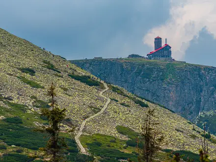
- Murodo (2,450 m): The highest point of the route and the main alpine walking hub, with Mikurigaike pond, Jigokudani and access to Mount Tateyama / Oyama.
- Kurobe Dam (186 m): Japan’s tallest dam, completed in 1963. Visitors walk across the dam crest, with seasonal water discharge from late June to mid-October.
- Tateyama Ropeway: A 1.7 km single-span aerial tramway between Daikanbo and Kurobedaira, with no support towers and wide views over the mountains.
- Mikurigaike pond: An easy alpine loop near Murodo, roughly one hour, passing viewpoints and Mikurigaike Onsen with reflections of the surrounding peaks.
Challenges to expect
The core route is easy because it is ridden, but it still needs planning. You are dependent on paid transport, timetables and weather at 2,450 m around Murodo. Snow can linger into summer, and optional higher walks towards Mount Tateyama / Oyama involve rougher rocky or snowy ground. In peak seasons, allow time for stops, queues and transfers. If you want a true multi-day foot journey, consider the Kumano Kodo Nakahechi Route or the forested Jomon Sugi Trail.
HikeList Score
Tateyama-Kurobe Alpine Route scored 76/100 on HikeList's trail-quality metrics.
See score breakdownHide breakdown
- Ideal length 55
- Balanced challenge 60
- Scenery & wildness 98
- Varied terrain 71
- Accommodation 83
- Food & support 81
- Path quality 80
- Season flexibility 89
Computed from length, challenge, scenery & wildness, terrain variety, accommodation, food & support, path quality and season flexibility.
 Japan
JapanShow more data Show less
- Mountainous
- Forest
- Paved
- Rocky
- Snow
- Hotels
- Lodges
- Huts
- Wheelchair Accessible
- Stroller Accessible
- Family Friendly
- Restrooms
- Water Sources
- Shelters
Photos from hikers
Taken on the trail by people who've reviewed Tateyama-Kurobe Alpine Route.
Ride the linked transport chain from Tateyama Station through Bijodaira, Midagahara and Murodo, then continue via Daikanbo, Kurobedaira, Kurobe Dam and the Kanden Tunnel electric bus to Ogizawa. The transport itself takes roughly 3.5-4 hours; with stops and short walks, most visitors take 6-8 hours end to end.
Reviews
How would you rate Tateyama-Kurobe Alpine Route?
Tap a star to start your review — you could be the first.