Tamar Valley Discovery Trail
How would you rate Tamar Valley Discovery Trail?
Tap a star to share your experience and help other hikers.
Tamar Valley Discovery Trail: Devon–Cornwall Valley Walk
HikeList Score
Tamar Valley Discovery Trail scored 86/100 on HikeList's trail-quality metrics.
See score breakdownHide breakdown
- Ideal length 66
- Balanced challenge 100
- Scenery & wildness 71
- Varied terrain 100
- Accommodation 100
- Food & support 94
- Path quality 84
- Season flexibility 89
Computed from length, challenge, scenery & wildness, terrain variety, accommodation, food & support, path quality and season flexibility.
The Tamar Valley Discovery Trail is a 50 km / 31 mile point-to-point walk through the Tamar Valley National Landscape on the Devon–Cornwall border in England. It usually takes 2–3 days and is best treated as a moderate route: mostly easy riverside, woodland and lane walking, but with short steep climbs and one important tidal crossing at Lopwell Dam. It suits hikers who want a lowland long-distance trail with railway escape points, mining heritage and estuary scenery rather than remote mountain terrain.
Route Overview
The trail runs north from Tamerton Foliot, on the edge of Plymouth, to Launceston, finishing near Launceston Castle. The route passes Lopwell Dam, Bere Alston, Calstock, Gunnislake, Chilsworthy / Latchley, Luckett, Horsebridge, Milton Abbot, Dunterton, Lawhitton and then Launceston. It is a linear walk, but the Tamar Valley Line stations at Bere Alston, Calstock and Gunnislake make day-section logistics much easier. Cotehele and Morwellham Quay sit close to the route as short detours, not main trail stages. For other gentler lowland options, compare the Ashby Canal Trail and Amber Valley Route.
A frontier valley shaped by mining, orchards and old routes
The Tamar Valley forms much of the historic boundary between Devon and Cornwall. The area was designated an Area of Outstanding Natural Beauty in 1995 and is now a National Landscape. Around Calstock and Gunnislake, the trail passes through the Cornwall and West Devon Mining Landscape World Heritage Site, where engine houses, chimneys and old workings mark the valley’s industrial past. The route can also be linked with the West Devon Way and Two Castles Trail to create the roughly 90-mile “West Devon Triangle”.
Notable highlights
- Lopwell Dam: A tidal weir and nature reserve about 3.5 miles / 5.7 km from the start. The causeway is impassable for roughly two hours either side of high tide, so this is the key timing point on the trail.
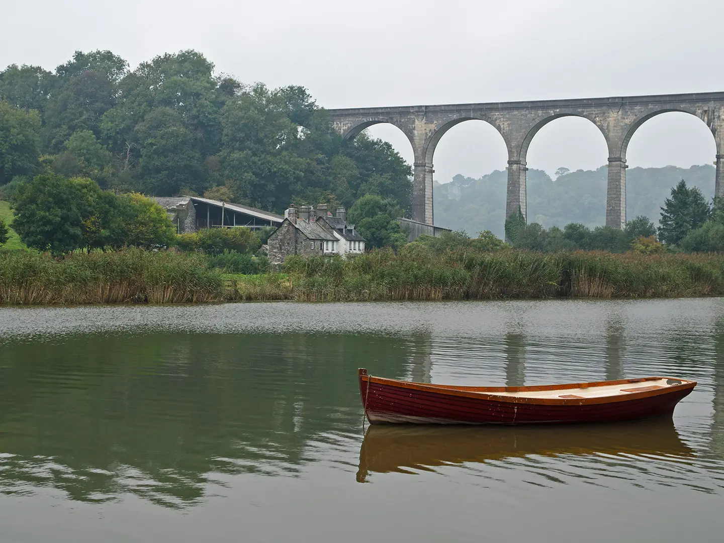
- Calstock Viaduct: A 12-arch railway viaduct about 120 ft / 37 m high, carrying the Tamar Valley Line above Calstock. It is one of the most recognisable landmarks on the walk.
- Cornwall and West Devon Mining Landscape: Around Gunnislake and Calstock, the route passes engine houses, chimneys and old mine workings, including Okel Tor Mine, within the UNESCO-inscribed mining landscape.
- Tamar Valley Line: The Plymouth–Gunnislake branch railway shadows parts of the route, with useful stations at Bere Alston, Calstock and Gunnislake for day walks or bail-out points.
- Launceston Castle: The trail finishes near this Norman motte-and-bailey castle in the ancient Cornish capital, once an important control point on the main route into Cornwall.
Challenges to expect
Expect mixed surfaces: dirt and gravel paths, woodland tracks, tarmac lanes and mud after rain. The walking is mostly easy, but the steep wooded valley sides add short, sharp climbs and the total ascent is about 1,460 m. Lopwell Dam needs tide planning, and the historic Calstock ferry has been unreliable. If you want a tougher upland contrast, see the Beacons Way; for a longer coastal route, compare the Anglesey Coastal Path.
HikeList Score
Tamar Valley Discovery Trail scored 86/100 on HikeList's trail-quality metrics.
See score breakdownHide breakdown
- Ideal length 66
- Balanced challenge 100
- Scenery & wildness 71
- Varied terrain 100
- Accommodation 100
- Food & support 94
- Path quality 84
- Season flexibility 89
Computed from length, challenge, scenery & wildness, terrain variety, accommodation, food & support, path quality and season flexibility.
 United Kingdom
 England
Show more data Show less
- Riverside
- Estuary
- Woodland
- Farmland
- Pasture
- Lanes
- Dirt
- Gravel
- Woodland Tracks
- Tarmac
- B&Bs
- Guesthouses
- Inns
- Campsites
- Family Friendly
- Dog Friendly On Leash
- Restrooms
- Non Potable Water Sources
- Established Campsites
- Picnic Areas
- Public Transport Access Points
Download Our Full Guide to Tamar Valley Discovery Trail FREE!
Get our comprehensive guide to this hike for free. Save it for later reading or print out at home.

Photos from hikers
Taken on the trail by people who've reviewed Tamar Valley Discovery Trail.
Tamar Valley Discovery Trail: The Complete Guide
 i
Image by Gary
i
Image by Gary The Tamar Valley Discovery Trail is a compact but rewarding long-distance walk along the Devon–Cornwall border, linking Tamerton Foliot on the edge of Plymouth with Launceston’s castle-topped hill. It suits walkers who want wooded river valleys, estuary paths, quiet lanes and mining heritage rather than remote upland terrain.
The route follows the Tavy estuary and River Tamar through a changing lowland landscape of quays, pasture, woodland tracks and steep-sided valleys. Around Calstock and Gunnislake, old mine workings and the great Calstock Viaduct give the walk a strong sense of industrial history.
This is a well-waymarked point-to-point trail, marked with distinctive apple-outline wayposts, and it can be completed in two or three days. The Tamar Valley Line makes section walking practical, with useful stations at Bere Alston, Calstock and Gunnislake.
The walking is moderate rather than technical, but it is not flat: short, sharp climbs add up to around 1,460 m of ascent. Planning matters more than navigation, especially the tidal causeway at Lopwell Dam and the non-running Calstock ferry, which makes the Bere Alston–Calstock train the practical river crossing.
This guide covers stages, daily planning, accommodation, food, transport, terrain and the common mistakes to avoid.
Stage-by-Stage Guide
Stage 1: Tamerton Foliot to Calstock via Lopwell Dam, Bere Ferrers and Bere Alston
This is the most logistically sensitive stage of the Tamar Valley Discovery Trail. It starts beside the Tavy estuary at Tamerton Foliot, on the northern edge of Plymouth, then follows wooded tidal valley country towards Lopwell Dam before continuing through the Bere Peninsula to Bere Ferrers and Bere Alston.
The walking is low-level but not flat. Expect riverside and estuary paths, woodland tracks, pasture, farmland and quiet lanes, with short, steep pulls where the route climbs out of the wooded valley sides. After rain, the woodland and field sections can be muddy, so waterproof footwear is useful even though this is not upland terrain.
Lopwell Dam is the key feature and the key constraint. The causeway is impassable for roughly two hours either side of high water, so this stage should be built around the tide table rather than treated as a normal riverside walk. If the tide timing is wrong, the delay can be long enough to disrupt the whole day.
Beyond Lopwell, the route works north through the Bere Peninsula, passing Bere Ferrers and Bere Alston before the onward link to Calstock. The historic Calstock ferry across the Tamar has not been running, so the practical crossing for this stage is by train between Bere Alston and Calstock on the Tamar Valley Line. Train times are limited and should be checked before travelling.
Calstock is one of the best overnight stops on the trail, with accommodation and services more likely here than in the smaller villages. Provision is still scattered rather than dense, so book ahead and do not assume late arrivals will be easy to accommodate. Carry enough food and water for the day from the start, especially if walking outside peak visitor hours.
Public transport is relatively good for this stage compared with the rest of the route. Plymouth is the main gateway for reaching Tamerton Foliot, and Bere Alston and Calstock both have Tamar Valley Line stations. This makes the stage workable as a day walk or as the first leg of a longer itinerary, provided the railway timetable and tide window line up.
Navigation is generally straightforward because the route is comprehensively waymarked with distinctive apple-outline wayposts. Even so, carry a proper map or offline mapping: the combination of tidal crossing, optional local loops and the rail transfer at Bere Alston makes this the stage where assumptions most often cause problems. OS Explorer 108 covers the lower Tamar Valley and Plymouth area.
Key warnings for this stage are practical rather than technical: check Lopwell Dam tide times, check Tamar Valley Line trains, and allow for mud in woodland and pasture. The walking itself is moderate, but missed transport or an impassable causeway can turn a short walking day into a difficult logistics day.
Stage 2: Calstock to Horsebridge via Gunnislake, Chilsworthy, Latchley and Luckett
This is the mining-heritage stage of the trail, with the route leaving Calstock beneath the prominent railway viaduct and working through the Tamar Valley around Gunnislake before continuing north through smaller settlements and countryside to Horsebridge. It is shorter than the first stage, but the valley sides make it more energetic than the distance suggests.
The terrain is a mix of woodland paths, old industrial landscapes, farmland, pasture and lanes. Around Calstock and Gunnislake, the trail passes through part of the Cornwall and West Devon Mining Landscape UNESCO World Heritage Site, with old workings, chimneys, lime kilns and engine-house remains such as Okel Tor Mine in the wider route corridor.
The Calstock Viaduct is the defining landmark at the start of the stage. Built in the early 20th century from more than 11,000 precast concrete blocks, it carries the Tamar Valley Line high above the village and river. Further on, New Bridge at Gunnislake provides another major landmark: an early 16th-century granite bridge over the Tamar and a Scheduled Ancient Monument.
Gunnislake is the most useful service point on this stage and is also the last Tamar Valley Line station on the route. After Gunnislake, the trail becomes more rural as it passes through Chilsworthy, Latchley and Luckett towards Horsebridge. Food and water should be topped up at Calstock or Gunnislake; do not rely on finding regular shops or cafés later in the day.
Accommodation is more concentrated around Calstock and Gunnislake than at the smaller settlements beyond. If ending at Horsebridge, arrange accommodation or onward transport in advance rather than assuming there will be a convenient bed at the bridge itself. This should be checked before travelling.
Public transport is useful at the start and early part of the stage because both Calstock and Gunnislake are on the Tamar Valley Line. Beyond Gunnislake, railway access drops away, so Horsebridge is a road-access finish rather than a rail-access finish. Any taxi, lift, bus connection or accommodation transfer should be arranged before setting off.
Navigation remains well waymarked, but this stage has more junctions through woodland, lanes and old mining ground where it is worth checking the map rather than following the most obvious track. The route also shares the wider valley with other paths and optional links, including the Luckett–Kit Hill link, so stay alert for the main Discovery Trail waymarks.
The main walking challenges are mud after wet weather, short sharp climbs, lane walking and normal field-walking issues such as gates and livestock. There is no mountain exposure, but the cumulative ascent is noticeable and the rural second half of the stage has fewer escape options than the settlements near the railway.
Stage 3: Horsebridge to Launceston via Milton Abbot, Dunterton and Lawhitton
The final stage leaves the Tamar crossing at Horsebridge and heads through quieter inland countryside towards Launceston. It is a more rural day than the first two stages, with fewer obvious transport fall-backs and a finish in the hilltop town beside Launceston Castle.
Horsebridge itself is a major landmark: a fine medieval stone bridge over the Tamar and a reliable dry crossing on the Devon–Cornwall border. From there, the trail continues through Sydenham Damerel, Milton Abbot, Dunterton and Lawhitton before reaching Launceston.
Underfoot, expect a practical mix of field paths, pasture, tracks and quiet lanes. The high ground on the trail is modest lowland country rather than open fell, but the route still gains and loses height across the ridges and valley sides. After prolonged rain, field edges and woodland sections can be muddy.
This is the stage where carrying a full day’s food and water is most important. The intermediate villages are small, and reliable walker services should not be assumed. Launceston is the clear end-of-day service centre, with accommodation and onward transport options more likely than in the villages before it.
Accommodation at Launceston should still be booked in advance, especially if walking during busy holiday periods or arriving late in the day. The town has no railway station, so departure needs to be planned by bus, lift or road transfer. Buses connect Launceston with places such as Plymouth and Exeter, but current routes and times should be checked before travelling.
There are no Tamar Valley Line stations on this final stage. Road access is possible through the villages and at Launceston, but this is not as easy to break into short public-transport sections as the Calstock and Gunnislake part of the trail. Anyone section-hiking should plan the return journey before starting from Horsebridge.
Navigation is again supported by apple-outline wayposts, but carry OS Explorer 112 or reliable offline mapping for the Launceston end of the route. The final approach into town is straightforward in principle, but field exits, lane junctions and settlement edges are exactly where waymarks can be missed if walking tired.
The finish beside Launceston Castle gives the trail a clear endpoint, but do not treat the last day as a formality. It is rural, service-light and still contains enough ascent to feel like a proper walking day, particularly with a multi-day pack.
Recommended Itinerary
The Tamar Valley Discovery Trail works best as a 3-day walk for most hikers. That keeps the daily distances moderate while leaving enough flexibility for the two main logistical constraints: the tidal causeway at Lopwell Dam and the current lack of a practical ferry crossing near Calstock.
Standard itinerary — 3 days
| Day | From | To | Approx. distance | Why this stage makes sense | Services/accommodation notes |
|---|---|---|---|---|---|
| 1 | Tamerton Foliot | Calstock, via Lopwell Dam, Bere Ferrers and Bere Alston | ~20 km | This is the longest day, but it gets the tidal Lopwell Dam crossing and the lower Tavy/Tamar estuary section completed in one stage. The day needs planning around high tide, as the Lopwell Dam causeway is impassable for roughly two hours either side of high water. | Calstock is one of the better overnight bases on the route. The historic Calstock ferry has not been running, so plan around the practical Bere Alston–Calstock train crossing and check the Tamar Valley Line timetable before travelling. |
| 2 | Calstock | Horsebridge, via Gunnislake, Chilsworthy, Latchley and Luckett | ~14 km | A shorter but useful middle day through the steeper wooded Tamar-side country and the mining-heritage area around Calstock and Gunnislake. It also includes the reliable river crossing at Horsebridge. | Services and accommodation are more concentrated around Calstock and Gunnislake than at Horsebridge. If staying at or near Horsebridge, book ahead and check exactly how you will reach your accommodation. |
| 3 | Horsebridge | Launceston, via Milton Abbot, Dunterton and Lawhitton | ~15 km | This gives a manageable final rural stage into Launceston, finishing at the hilltop town beside Launceston Castle. There is no railway station at Launceston, so onward transport must be planned separately. | Launceston has the strongest end-of-walk services, but bus times should be checked before travelling. If returning to Plymouth or another rail hub the same day, do not assume late onward connections. |
Slower variant — 4 days / rail-assisted
This suits walkers who want shorter days, more time around Calstock and Gunnislake, or a less risky first day if the Lopwell Dam tide window is awkward. Exact stage distances depend on where accommodation is available, so check official mapping before booking.
| Day | From | To | Approx. distance | Why this stage makes sense | Services/accommodation notes |
|---|---|---|---|---|---|
| 1 | Tamerton Foliot | Bere Alston, via Lopwell Dam and Bere Ferrers | Check official mapping before booking | Splits the long first stage and reduces the pressure of combining the Lopwell Dam tide crossing with reaching Calstock the same day. | Bere Alston has a Tamar Valley Line station and is one of the useful break points for section walkers. Accommodation should still be booked ahead. |
| 2 | Bere Alston | Calstock or Gunnislake | Check official mapping before booking | Allows time to deal with the practical Tamar crossing issue near Calstock and to use the Tamar Valley Line where needed. It also gives a more relaxed day around Calstock Viaduct and the mining-landscape features near Calstock and Gunnislake. | Check the Bere Alston–Calstock rail option before travelling, as the ferry has not been running and the branch line has only a few trains each day. Calstock and Gunnislake are among the more practical overnight bases. |
| 3 | Calstock or Gunnislake | Horsebridge | Check official mapping before booking | Keeps the central Tamar Valley section shorter, which is helpful because the route has repeated short climbs from the wooded valley sides despite being a lowland trail. | Horsebridge is a logical route break, but provision is scattered. Book accommodation or arrange your overnight logistics before setting out. |
| 4 | Horsebridge | Launceston | ~15 km | Leaves the northern rural section as a self-contained final day into Launceston. | Launceston is the natural finish for accommodation and onward buses, but it has no rail station. This should be checked before travelling. |
Faster variant — 2 days
A 2-day schedule is realistic only for fit walkers who are comfortable with a long second day and who have already sorted the Lopwell Dam tide window, the Bere Alston–Calstock crossing and onward transport from Launceston.
| Day | From | To | Approx. distance | Why this stage makes sense | Services/accommodation notes |
|---|---|---|---|---|---|
| 1 | Tamerton Foliot | Calstock | ~20 km | Uses the same logical first stage as the standard itinerary, reaching a strong overnight base on the Tamar Valley Line after the key tidal and river-crossing logistics. | Check tide tables for Lopwell Dam and the Tamar Valley Line timetable before committing to accommodation. |
| 2 | Calstock | Launceston, via Gunnislake, Horsebridge, Milton Abbot, Dunterton and Lawhitton | ~29 km | Combines the standard second and third stages into one long day. The distance is not extreme by upland standards, but the cumulative ascent and repeated valley-side climbs make it a demanding lowland day. | After Gunnislake there are fewer easy rail-based escape options. Carry what is needed for the day, start early, and check Launceston bus options before travelling. |
For most independent hikers, the 3-day plan is the safest balance of distance, accommodation practicality and transport resilience. The 4-day version is the best choice if using the Tamar Valley Line for shorter sections; the 2-day version is best kept for strong walkers with flexible transport and pre-booked overnight plans.
Planning the Route
The Tamar Valley Discovery Trail is short enough for a long weekend, but it rewards careful staging more than its mileage suggests. The two planning points that matter most are the tidal crossing at Lopwell Dam and the lack of a currently reliable ferry crossing at Calstock, which makes the Tamar Valley Line an important part of the route plan.
Most walkers should allow three days. A two-day crossing is realistic for fit walkers who are happy with longer days and have accommodation and transport lined up, but it leaves less margin for tide timing, muddy woodland paths and the short, sharp climbs out of the river valleys.
Choosing a 2-day or 3-day itinerary
The natural three-day split uses Calstock and Horsebridge as stage ends. This keeps each day manageable and places the first overnight stop where transport and accommodation are more practical.
| Option | Best for | Main planning issue |
|---|---|---|
| 3 days | Most independent walkers, first-time visitors to the valley, anyone using public transport | Book accommodation ahead, especially away from the railway-served villages |
| 2 days | Strong walkers travelling light, with flexible transport or pre-booked accommodation | Longer walking days, less flexibility around Lopwell Dam and the Bere Alston–Calstock train connection |
| Day sections | Walkers based in Plymouth or the Tamar Valley | Works best on the southern half using the Tamar Valley Line; check train times carefully |
The route is not dictated by mountain huts or remote bothies, but by river crossings, railway stations and scattered accommodation. Bere Alston, Calstock, Gunnislake and Launceston are the key places to think about when booking beds, while smaller villages should not be treated as guaranteed service stops.
Stage planning in practice
| Stage | Practical notes |
|---|---|
| Tamerton Foliot to Calstock | The most logistically sensitive day. Lopwell Dam is only about 5.7 km from the start and its causeway is impassable for roughly two hours either side of high water, so the day’s start time should be built around the tide table. With the Calstock ferry not running, the practical way across the Tamar at this point is by train between Bere Alston and Calstock. |
| Calstock to Horsebridge | A shorter middle day on paper, but the route climbs in and out of the wooded valley sides and passes through the mining landscape around Calstock and Gunnislake. Calstock and Gunnislake are useful public-transport points; after this, escape options become less straightforward. |
| Horsebridge to Launceston | A rural final stage with fewer obvious transport fallbacks than the railway-served southern section. Plan food, water and onward travel before leaving Horsebridge, and remember that Launceston has no railway station. |
Tide and river-crossing logistics
Lopwell Dam is the one timing constraint that can stop progress completely. The causeway cannot be treated as an all-day crossing: plan to reach it outside the high-water window, allowing extra time for slow ground or navigation pauses on the approach from Tamerton Foliot.
The Tamar crossing near Calstock also needs planning. The historic ferry has not been operating, so walkers should use the Tamar Valley Line between Bere Alston and Calstock as the practical link. Train times are limited and should be checked before travelling.
Accommodation and resupply
Accommodation is mixed but scattered: B&Bs, guesthouses, inns, campsites and self-catering options exist in the valley, but they are not evenly spaced along the trail. Booking intermediate nights ahead is strongly advised, particularly if walking over weekends, holidays or outside the main summer season.
Food planning should be conservative. Do not assume every village has open shops, pubs or cafés at the time you pass through. Carry enough food for the walking day, and top up where services are known to fit the itinerary, especially around the larger valley settlements and Launceston.
Water is simpler than on a remote upland route, but it still needs forethought. Carry a full day’s supply unless accommodation or confirmed stops provide reliable refills. Streams and rivers along the route should not be relied on without treatment.
Navigation and maps
The trail is comprehensively waymarked with distinctive apple-outline wayposts, which makes navigation easier than on many lowland rights-of-way routes. Even so, carry mapping: woodland junctions, field edges, lanes and village exits can still cause wrong turns, especially in poor light or after diversions.
Useful paper mapping includes OS Explorer 108 for the Lower Tamar Valley and Plymouth area and OS Explorer 112 for the Launceston and Holsworthy area; OS Landranger 201 also covers the wider route. A downloaded GPS line is helpful, but should not replace a map and the ability to relocate from rights of way and local features.
Transport and section hiking
The Tamar Valley Line makes the southern half of the trail very section-hikeable, with useful stations at Bere Alston, Calstock and Gunnislake. This is also the best safety net if weather, tiredness or tide timing disrupts the first half of the walk.
Public transport becomes less convenient towards the northern end. Launceston is reached by bus rather than rail, including services from larger centres such as Plymouth and Exeter, but exact routes and times should be checked before travelling.
For section hiking, build the day around train times rather than assuming frequent services. There are only a few trains each day on the branch line, so a missed connection can mean a long wait or the need for a taxi.
Shortening, extending and variants
The easiest way to shorten the walk is to use the Tamar Valley Line for individual sections between the southern trailheads and railway-served villages. Once beyond Gunnislake, shortening the route becomes more dependent on buses, taxis or pre-arranged lifts.
Optional waymarked variants exist, including a seasonal Tavy estuary loop, a Bere Peninsula loop, a Luckett–Kit Hill link and a Milton Abbot–Lifton field-path option. These are best treated as add-ons rather than essential parts of the main line, and their current status should be checked before travelling.
For a longer linked walk, the Tamar Valley Discovery Trail can connect with routes such as the West Devon Way and the Two Castles Trail as part of the wider West Devon Triangle. It also shares stretches with the Tamara Coast to Coast Way, so check signage carefully where routes overlap.
Weather, season and ground conditions
Spring, summer and autumn are the most suitable seasons. The trail is lowland rather than mountainous, but wet weather can still make woodland tracks, field paths and riverside sections muddy and slow.
After heavy rain, allow extra time for the steep valley-side climbs and descents. In winter or after prolonged wet spells, daylight, mud and limited transport can make the route feel more committing than the mileage suggests.
There is no special permit system for walking the route, but normal countryside access rules apply. Current route diversions, tide times and transport timetables should all be checked before setting off.
Towns, Villages and Overnight Stops
Accommodation on the Tamar Valley Discovery Trail is scattered rather than continuous. The most practical overnight bases are around Bere Alston, Calstock, Gunnislake and Launceston, with a mix of B&Bs, guesthouses, inns, campsites, self-catering and other rural stays in the wider valley.
Book intermediate nights ahead, especially if walking the route in 2–3 days. Do not assume that every village has food, a pub, a shop or accommodation available on the day.
Tamerton Foliot
Tamerton Foliot is the southern trailhead, on the northern edge of Plymouth beside the Tavy estuary. The route starts from the village and is waymarked from here with the apple-outline Discovery Trail posts.
It is mainly a start-point rather than an overnight stop. Walkers arriving by train will usually find Plymouth the more practical base, as it is the main rail gateway on the London–Penzance line; local onward transport to Tamerton Foliot should be checked before travelling.
Accommodation, food and shop details in Tamerton Foliot itself should be checked before committing to a first-night plan. If starting early, carry enough food and water to get through the first section, especially because the timing at Lopwell Dam can dictate the day.
Lopwell Dam
Lopwell Dam is reached early on the first day, about 5.7 km from Tamerton Foliot. It is a tidal weir and nature reserve, and it is one of the most important planning points on the whole trail.
This is not an overnight base. The key issue is the causeway crossing, which is impassable for roughly two hours either side of high water.
Check tide times before travelling and plan the start time around this crossing. Food, shops and accommodation should not be relied on here.
Bere Ferrers
Bere Ferrers lies on the first stage between Lopwell Dam and Bere Alston. It is useful as a route landmark on the Bere Peninsula, but it should not be treated as a guaranteed resupply or overnight point without prior arrangements.
Accommodation and food availability should be checked before travelling. For most walkers, Bere Ferrers is a pass-through village rather than a natural stage end.
Bere Alston
Bere Alston is one of the most useful practical stops on the trail. It sits on the first day’s route before the onward crossing towards Calstock, and accommodation is more concentrated here than in many smaller villages on the route.
The village is also served by the Tamar Valley Line, making it a valuable break point for section walkers and anyone needing to leave the route. The timetable is thin, so train times must be checked before relying on it.
Bere Alston is especially important because the historic Calstock ferry has not been running. The practical way to cross the Tamar at this point is by train between Bere Alston and Calstock, so build that rail hop into the day rather than assuming a foot crossing is available.
Calstock
Calstock is one of the strongest overnight choices on the trail and is the common end point for a three-day first stage from Tamerton Foliot. It sits beside the Tamar below the Calstock Viaduct, with mining-heritage sites in the surrounding valley.
Accommodation is relatively concentrated here compared with the smaller inland villages. Food and opening hours should still be checked before booking, particularly outside peak holiday periods or if arriving late.
Calstock has a Tamar Valley Line station, making it a good access, exit or stage-start point. It is also the practical partner to Bere Alston for the river crossing by train while the Calstock ferry is not operating.
Gunnislake
Gunnislake is another key service and transport point, reached after Calstock on the second stage. It is close to New Bridge, the historic granite crossing of the Tamar, and sits within the mining landscape around the middle of the route.
Accommodation is among the more concentrated on the trail here, making Gunnislake a sensible alternative overnight stop to Calstock or a shorter first-day finish if using the railway. Food and shop details should be checked before travelling.
Gunnislake is served by the Tamar Valley Line, which makes it one of the best bail-out points. Train services are limited, so do not arrive assuming there will be a convenient departure.
Chilsworthy
Chilsworthy is a small settlement on the second stage between Gunnislake and Latchley. It is best treated as a route marker rather than a dependable overnight stop.
Accommodation, food and shop availability should be checked before travelling. Carry enough supplies from Calstock or Gunnislake if walking through without a confirmed stop.
Latchley
Latchley lies on the second stage between Chilsworthy and Luckett. It can be useful for navigation and pacing, but there is no reason to rely on it for trail logistics unless a specific booking has been made.
Do not assume food, accommodation or regular transport from here. This should be checked before travelling.
Luckett
Luckett comes before Horsebridge on the second stage. It is also associated with the optional Luckett–Kit Hill link, but for the main Discovery Trail it is principally a through-point between Gunnislake and Horsebridge.
Accommodation and food availability should be checked before travelling. If planning to stop around Luckett, book in advance and be clear about how far the accommodation is from the signed trail.
Horsebridge
Horsebridge is the usual second-night target on the three-day itinerary, sitting at an important bridge crossing over the Tamar. It is a strong route landmark and a logical place to break the walk between the mining valleys and the final approach to Launceston.
It should not, however, be assumed to have the same level of accommodation and services as Calstock, Gunnislake or Launceston. If using Horsebridge as a stage end, arrange accommodation, food and any transfer logistics before setting out.
There is no rail link listed for Horsebridge. Walkers who need public transport should plan around the Tamar Valley Line earlier on the route or the bus links at Launceston.
Sydenham Damerel
Sydenham Damerel lies on the final stage after Horsebridge. It is a quiet inland point on the route rather than a major service centre.
Food, accommodation and transport options should be checked before travelling. Most walkers will pass through and continue towards Milton Abbot or Launceston.
Milton Abbot
Milton Abbot is one of the more useful named places on the final day between Horsebridge and Launceston. It can help break up the last stage and is also associated with an optional Milton Abbot–Lifton field-path alternative.
Do not rely on it as a resupply or overnight stop without checking current options. If planning a slower itinerary, any accommodation around Milton Abbot should be booked ahead because provision on this northern section is more scattered.
Dunterton
Dunterton sits between Milton Abbot and Lawhitton on the final approach to Launceston. It is best treated as a navigation point rather than a logistics base.
Accommodation, food and transport availability should be checked before travelling. Carry what is needed for the final stage from Horsebridge unless a specific stop has been arranged.
Lawhitton
Lawhitton is one of the last villages before Launceston. By this point the practical aim for most walkers is to continue to the finish rather than stop short.
Services should not be assumed. If poor weather, injury or timing makes a stop necessary, options should be checked before travelling rather than decided on the day.
Launceston
Launceston is the northern trailhead and the best place to plan a final overnight stay. The route finishes in the ancient hilltop town beside Launceston Castle, and accommodation is more concentrated here than in the smaller villages immediately before it.
It is also the key onward-transport point at the end of the walk. Launceston has no railway station, so onward travel is by bus, including links from Plymouth and Exeter; current routes and times should be checked before travelling.
For a relaxed finish, book accommodation in Launceston rather than trying to connect immediately after the final stage. This gives more margin if the last day takes longer than expected on muddy tracks, lanes and short valley climbs.
Getting to the Start
By train
Plymouth is the practical rail gateway for the start of the Tamar Valley Discovery Trail. It sits on the main London–Penzance line, making it the easiest approach by public transport from London, the Midlands via connecting services, Devon, Cornwall and the wider national rail network.
The trail itself begins at Tamerton Foliot, on the northern edge of Plymouth, rather than at a railway station. From Plymouth, allow for a local bus or taxi transfer to Tamerton Foliot before starting; exact local connections and taxi availability should be checked before travelling.
If using the Tamar Valley Line later in the walk, note that it runs from Plymouth to Gunnislake with useful stations at Bere Alston, Calstock and Gunnislake. Services are limited, with only a few trains each day, so do not assume a turn-up-and-go service.
By bus
Local bus access to Tamerton Foliot should be planned from Plymouth. Current routes, stopping points and Sunday or evening services should be checked before travelling, especially if starting early to meet the Lopwell Dam tide window.
Launceston, the finish, has no railway station and is reached by bus, including services from Plymouth and Exeter. If leaving a vehicle at the start or planning a public-transport return at the end, check the Launceston bus timetable before committing to the itinerary.
By car
Driving to Tamerton Foliot can work for a day section or if someone is collecting you, but it is less straightforward for the full point-to-point route because the walk finishes in Launceston. There is no rail link from Launceston back to Plymouth, so the return depends on bus services or a pre-booked taxi.
Long-stay parking details for Tamerton Foliot are not supplied here and should not be assumed. If starting by car, check local parking restrictions before leaving a vehicle, and avoid relying on informal village parking for several days.
A common approach is to travel to Plymouth by train, take a bus or taxi to Tamerton Foliot, then return from Launceston by bus at the end. This avoids having to recover a car from the start.
From the nearest airport
No airport is directly useful for the trailhead. For most walkers flying in, the practical plan is to reach Plymouth first, then continue to Tamerton Foliot by local transport or taxi.
Airport-to-Plymouth rail and coach links, onward timings, and late-arrival options should be checked before travelling. If arriving the day before the walk, staying in or near Plymouth is usually simpler than trying to make a same-day transfer and start.
Where to stay before starting
The most convenient pre-walk base is Plymouth, because it is the rail hub and gives the simplest onward access to Tamerton Foliot in the morning. This is particularly useful if the first day includes the Lopwell Dam crossing, where the tidal causeway is impassable for roughly two hours either side of high water.
Staying closer to Tamerton Foliot may reduce morning travel, but local accommodation availability should be checked before travelling. If planning a very early start, arrange the bus or taxi transfer in advance rather than assuming one will be available on the day.
Getting Home from the Finish
By train
Launceston has no railway station, so there is no direct train from the finish. The practical rail gateway for this walk is Plymouth, which is on the main London–Penzance line and also connects with the Tamar Valley Line.
From Launceston, plan to reach a railway station by bus or taxi before continuing by train. The Tamar Valley Line serves Gunnislake, Calstock and Bere Alston, but services are limited, with only a few trains each day, so it is not a turn-up-and-go option. Timetables should be checked before travelling, especially if using the railway to return towards Plymouth after finishing the trail.
If the final day ends late, staying in Launceston is usually the safer plan than relying on a same-day connection. Missing the last useful bus or rail connection can leave an expensive taxi as the only practical fallback.
By bus
Launceston is reached by bus, including links from Plymouth and Exeter. These are the key public-transport options for leaving the finish and connecting with larger rail hubs.
Bus times are timetable-dependent and may be limited in the evening, on Sundays and on public holidays. Check the current timetable before booking onward trains, and allow a margin after the final walking stage: the last section from Horsebridge to Launceston includes lanes, field paths and the climb into the hilltop town, so arrival time can easily slip in poor weather or mud.
For most walkers using public transport, the simplest plan is:
| Finish option | Practical use |
|---|---|
| Bus from Launceston to Plymouth | Best for returning to the main railway network and, if needed, towards the start area around Tamerton Foliot |
| Bus from Launceston to Exeter | Useful for onward travel towards Exeter and its rail connections |
| Overnight in Launceston, then bus next morning | Sensible if finishing late or if onward services are sparse |
By car/taxi
Because the Tamar Valley Discovery Trail is a point-to-point route, car logistics need planning. Leaving a vehicle at Launceston makes the finish straightforward, but requires reaching Tamerton Foliot at the start by public transport or taxi. Leaving a vehicle near the start means arranging transport back from Launceston after the walk.
Taxis can be useful for filling gaps between Launceston, Tamar Valley Line stations and Plymouth connections, but they should not be treated as instantly available in a rural finish town, particularly late in the day. Pre-booking is strongly recommended for evening finishes, group transfers, or returns to a parked car. Current availability and fares should be checked before travelling.
From the nearest airport
Air travel is not the natural transport choice for this route. The more practical end-to-end logistics are based around rail and bus links via Plymouth or Exeter, with Launceston reached by bus and Plymouth acting as the main rail gateway.
If flying, plan the onward journey around public transport from the chosen airport to Plymouth or Exeter, then onward by bus or rail as appropriate. Airport-to-trail details, late arrivals and Sunday connections should be checked before travelling.
Where to stay at the finish
Launceston is one of the main accommodation concentrations on the route, with options such as B&Bs, guesthouses, inns, campsites and self-catering in and around the town and wider valley. Booking ahead is sensible, particularly if finishing on a weekend or linking the trail with onward walking.
Staying overnight at the finish is often the best option if the final stage is walked as a full day from Horsebridge. It removes pressure to catch a late bus, gives a buffer for slow ground or poor weather, and makes onward travel by bus to Plymouth or Exeter much easier the following morning.
Which Direction Should You Walk?
The standard direction is south to north, from Tamerton Foliot to Launceston. This is the more natural way to plan the Tamar Valley Discovery Trail: it starts on the edge of Plymouth, follows the Tavy and Tamar valleys inland, passes the Calstock and Gunnislake mining landscape, then finishes at the hilltop town of Launceston beside Launceston Castle.
The reverse direction is perfectly possible, but it changes the logistics. In particular, it makes the Lopwell Dam tide timing less convenient and usually puts the awkward Launceston bus connection at the start rather than the end.
| Direction | Main advantages | Main drawbacks |
|---|---|---|
| Tamerton Foliot → Launceston | Easier access to the start via Plymouth; Lopwell Dam comes early, so tide timing is easier to control; strong finish at Launceston Castle; natural scenery progression from estuary to inland valley and hilltop town | Finish has no railway station, so onward bus planning from Launceston is needed |
| Launceston → Tamerton Foliot | More convenient finish near Plymouth’s rail hub; the Launceston bus transfer is dealt with before walking starts | Lopwell Dam falls near the end of the walk, which can be awkward if the tide is wrong; the finish at Tamerton Foliot is less of a landmark conclusion |
Transport and access
For most walkers, starting at Tamerton Foliot is simpler because Plymouth is the main transport gateway, with rail links on the London–Penzance main line. From Plymouth, the start is on the northern edge of the city, so the journey into the walk is more straightforward than beginning in Launceston.
Launceston has no railway station, so a south-to-north walk requires onward bus planning at the end. That is the main logistical disadvantage of the standard direction, and bus times should be checked before travelling.
Walking in reverse can be attractive if the priority is to finish closer to Plymouth and its rail connections. However, it means reaching Launceston by bus before the walk begins, which can make the first day more vulnerable to delays.
The Tamar Valley Line also matters in both directions. Stations at Bere Alston, Calstock and Gunnislake are useful for section walking or bailing out, but there are only a few trains each day, so the timetable needs checking whichever way you walk. As the Calstock ferry has not been running, the practical crossing between Bere Alston and Calstock is by train.
Tide timing at Lopwell Dam
This is the strongest argument for walking Tamerton Foliot to Launceston. Lopwell Dam is only about 5.7 km from the start, and the causeway is impassable for roughly two hours either side of high water.
In the standard direction, you can time the start from Tamerton Foliot around the tide window. If the crossing is not possible, the delay happens early in the walk, before the day has fully committed itself.
In reverse, Lopwell Dam comes late in the route. Arriving at a closed causeway near the end of the final day is much more disruptive, especially if there is onward travel to Plymouth or beyond.
Scenery and sense of progression
South to north gives the route a clear build. The walk begins beside the Tavy estuary at Tamerton Foliot, moves through the wooded Tamar Valley and the mining-heritage landscape around Calstock and Gunnislake, then finishes at Launceston Castle in the historic hilltop town.
The reverse direction still has the same landscapes, but the ending is less satisfying. Tamerton Foliot is a practical and pleasant start point, but Launceston is the stronger finish.
Climbing and terrain
There is no major climbing advantage either way. This is a lowland route, but the wooded valley sides create repeated short, sharp ascents and descents, and the total ascent is still significant for a 48–50 km walk.
Because the climbs are frequent rather than dominated by one long pass or ridge, reversing the direction does not make the walk meaningfully easier. Expect the effort to feel similar in both directions.
Accommodation flow
The standard three-day split works naturally as Tamerton Foliot to Calstock, Calstock to Horsebridge, then Horsebridge to Launceston. Accommodation and services are scattered rather than dense, with more options around places such as Bere Alston, Calstock, Gunnislake and Launceston, so intermediate nights should be booked ahead.
Reverse walkers can use the same break points in the opposite order, but the practical issue is still availability rather than direction. Do not assume that every village on the line of the trail has convenient accommodation.
Recommendation
Walk the Tamar Valley Discovery Trail from Tamerton Foliot to Launceston unless there is a specific transport reason to do the reverse. The standard direction gives easier access to the start, better control of the Lopwell Dam tide crossing, a more natural scenic progression and the more satisfying finish at Launceston Castle.
Choose the reverse only if finishing near Plymouth is more important than those advantages, and check the Lopwell Dam tide window, Tamar Valley Line timetable and Launceston bus connections before booking.
Accommodation Along the Route
Accommodation on the Tamar Valley Discovery Trail is workable, but it is not dense. This is a short long-distance route through small valley settlements, so the main planning rule is simple: decide the overnight stops before setting out and book the intermediate nights ahead.
The best choice is around Bere Alston, Calstock, Gunnislake and Launceston. Elsewhere, provision is scattered and may mean B&Bs, inns, campsites, self-catering, chapel barns or yurts rather than a predictable choice of walk-in rooms.
Best overnight stops
For a three-day walk, Calstock is the most natural first overnight stop, following the common Tamerton Foliot to Calstock stage via Lopwell Dam, Bere Ferrers and Bere Alston. It also fits the route logistics well because the Calstock ferry has not been running, making the train between Bere Alston and Calstock the practical river crossing.
The second night is less straightforward. Horsebridge is the logical stage break by distance, but accommodation is much thinner on this northern middle section. If no suitable bed is available in or near Horsebridge, arrange a taxi transfer to accommodation elsewhere and return the next morning, or reshape the itinerary around Gunnislake and Launceston.
For a two-day walk, the most practical overnight base is usually around Calstock, Bere Alston or Gunnislake, depending on pace and train times. This makes the second day longer, so it suits fitter walkers who are comfortable with the trail’s short, sharp valley climbs and a full day on foot.
Launceston is the strongest final overnight option. It is the trail finish and a more practical place to recover, eat and organise onward travel, though it has no railway station, so bus or taxi plans should be checked before travelling.
Accommodation by place
| Place | Accommodation level | Best for | Notes |
|---|---|---|---|
| Tamerton Foliot / northern Plymouth edge | Limited at the trailhead | Night before starting | The walk starts at Tamerton Foliot on the edge of Plymouth. If staying away from the start village, allow time to reach the trailhead in the morning. |
| Lopwell Dam | None to rely on | Tide-timed crossing only | This is a key tidal crossing, not a sensible overnight base. Plan the first day around the causeway timing rather than accommodation here. |
| Bere Ferrers | Limited | Shorter first day or rail-assisted staging | A small route village before Bere Alston. Only plan to stop here overnight if accommodation is booked in advance. |
| Bere Alston | Good | First-night option, railway logistics | One of the better accommodation areas on the route and a useful Tamar Valley Line station. Also important for the practical train crossing towards Calstock when the ferry is not operating. |
| Calstock | Good | Main first overnight stop | A strong base for the classic first stage and one of the most convenient places to stay mid-route. Book ahead at weekends and in the main walking season. |
| Gunnislake | Good | Alternative mid-route base or itinerary adjustment | Another useful accommodation cluster with a Tamar Valley Line station. Helpful if reshaping the walk, breaking the route differently or using rail-assisted sections. |
| Chilsworthy, Latchley and Luckett | Limited | Rural overnight only if pre-booked | These are not places to reach late in the day expecting several options. Secure accommodation and food arrangements before relying on them. |
| Horsebridge | Limited | Logical second-night area on a three-day schedule | A good mileage break but not a strong accommodation hub. If nothing suitable is available, use a pre-booked taxi transfer to a nearby base. |
| Sydenham Damerel, Milton Abbot, Dunterton and Lawhitton | Limited | Shortening or adjusting the final stage | Accommodation is scattered on the approach to Launceston. Any stop here needs advance booking and may involve leaving the line of the trail. |
| Launceston | Good | Final night and onward travel | The best end-of-walk base. It has no railway station, so onward bus or taxi arrangements should be checked before travelling. |
Booking strategy
This is not a route to walk on a turn-up-and-find-a-room basis. Small villages may have only one or two suitable options, and some self-catering or glamping-style places may have minimum stays, seasonal opening or be slightly off the trail.
Spring, summer and autumn are the main walking seasons, so weekend availability can tighten quickly. Book earlier if walking over bank holidays, school holiday periods or during settled summer weather.
When booking, ask three practical questions: whether early breakfast is possible, whether an evening meal is available nearby, and whether a packed lunch can be provided. On the quieter sections between Gunnislake, Horsebridge and Launceston, food and accommodation should be planned together rather than treated separately.
Using rail and taxis to solve awkward gaps
The Tamar Valley Line is useful for accommodation planning because it serves Bere Alston, Calstock and Gunnislake. These stations allow walkers to base themselves in one of the stronger accommodation areas and return to the trail for a section walk, but there are only a few trains each day, so the timetable must be checked before travelling.
Taxis can also make the route much easier, especially around Horsebridge or the final approach to Launceston. Do not assume a taxi will be available at short notice in the smaller villages; book transfers in advance, particularly for evening pick-ups or early morning returns to the trail.
A formal luggage-transfer network should not be assumed for this route. If walking inn-to-inn with heavier bags, ask accommodation providers whether they can help with bag movement, or arrange local taxis directly. This should be checked before travelling.
Camping and self-catering
Camping and more unusual valley accommodation, including yurts and converted rural buildings, can work well for flexible walkers, but they do not remove the need to plan. Sites may be seasonal, off-route, or unsuitable for a neat two- or three-day stage pattern.
Self-catering can be useful for groups, but it may not suit a one-night linear itinerary if minimum-stay rules apply. Confirm current availability, access from the trail and any food options before booking.
Camping and Wild Camping
Camping is possible on the Tamar Valley Discovery Trail, but it needs more advance planning than the modest distance might suggest. Accommodation is scattered along the valley, and while campsites and other informal rural stays exist in the wider Tamar Valley, there is no dense chain of guaranteed on-route camping stops at the natural stage ends.
For most walkers, B&Bs, inns or guesthouses around Bere Alston, Calstock, Gunnislake and Launceston are simpler. Camping works best if you are willing to make short detours, pre-book, and adjust stages around available pitches rather than relying on turning up at the end of each day.
Campsites and booked camping
No specific campsite list is included here because pitch availability, opening dates and facilities change seasonally. This should be checked before travelling.
When planning a camping itinerary, focus first on the middle of the route, particularly the Bere Alston, Calstock and Gunnislake area. These places are the most useful for walkers because they sit close to the Tamar Valley Line and break the trail naturally into manageable sections.
The northern half beyond Gunnislake becomes more rural, passing Chilsworthy, Latchley, Luckett, Horsebridge, Milton Abbot, Dunterton and Lawhitton before Launceston. Do not assume there will be an obvious campsite or shop at the end of a walking day in this section. Book a legal pitch, farm stay or accommodation before committing to a camping schedule.
A practical camping plan should allow for:
- detours from the signed route to reach a campsite or farm pitch;
- limited evening food options in smaller villages;
- carrying enough food between resupply points;
- checking the Tamar Valley Line timetable if using rail to reposition between Bere Alston, Calstock or Gunnislake;
- tide timing at Lopwell Dam, which can affect the first day’s schedule.
Wild camping legality and practical reality
Wild camping is not generally permitted in England without the landowner’s permission. The Tamar Valley Discovery Trail crosses a patchwork of farmland, woodland, lanes, riverside paths, village edges and protected landscapes, so it is not a suitable route for assuming that discreet wild camping will be acceptable.
The route also passes through the Tamar Valley National Landscape and near sensitive riverside and estuary environments, including the Lopwell Dam area. These are not places to light fires, leave waste, disturb wildlife or camp without permission.
If an overnight stop is needed away from a formal campsite, permission should be obtained from the landowner in advance. Where ownership or local restrictions are unclear, do not camp. This should be checked locally before relying on any informal arrangement.
Water and cooking
Do not rely on the River Tamar, River Tavy or small streams as drinking-water sources. The lower valley includes tidal reaches, agricultural land, settlements and historic mining areas, so untreated water is a poor planning assumption.
Carry enough water between villages and booked accommodation, and refill only from reliable taps, cafés, pubs, shops or campsites where available. Availability of public taps and opening hours should be checked before travelling.
Use a stove only where permitted by the campsite or landowner. Open fires are inappropriate on this route, particularly in woodland, farmland, protected landscape and riverside areas.
Leave No Trace on this route
Lowland valley walking leaves little margin for careless camping: paths pass close to homes, farms, livestock, woods and heritage sites. Keep all overnight stops legal, quiet and low impact.
Key rules for campers:
- camp only on a booked pitch or with explicit landowner permission;
- never light an open fire;
- pack out all rubbish, including food waste;
- use toilets where available and never contaminate streams, ditches or rivers;
- keep well away from livestock, crops, gates and farm access;
- avoid camping near heritage features, old mine workings, bridges or nature reserve areas;
- leave early and leave no visible trace.
Is camping worth it on the Tamar Valley Discovery Trail?
Camping can work for experienced, self-sufficient walkers who enjoy flexible rural logistics. It is less convenient for anyone expecting a campsite at every stage end.
Because the full trail is only normally walked over 2–3 days, lightweight accommodation is often the easier option. If camping, build the itinerary around confirmed pitches first, then fit the walking days around them rather than the other way round.
Food, Water and Resupply
The Tamar Valley Discovery Trail is a lowland route through villages rather than a wilderness walk, but food and water are not evenly spaced. Resupply is easiest at the start near Plymouth, around Bere Alston, Calstock and Gunnislake, and at the finish in Launceston. Between those places, several settlements are small rural villages where opening hours can be limited or seasonal.
Plan each walking day with lunch and snacks already packed. Do not assume that every village named on the route has an open shop, café or pub at the time you pass through, especially on Sundays, bank holidays, winter weekdays or later in the afternoon. Current opening times should be checked before travelling.
Food availability by section
| Section | Food availability | Water availability | Notes |
|---|---|---|---|
| Tamerton Foliot to Lopwell Dam | Stock up before leaving the Plymouth/Tamerton Foliot area. Food options become limited once the trail leaves the urban edge and follows the Tavy estuary. | Start with a full bottle from accommodation, a café/pub, or other treated tap-water source before setting off. | Lopwell Dam is a key timing point because the causeway is impassable near high water. Do not plan a meal or refill around the crossing unless a current facility has been checked. |
| Lopwell Dam to Bere Ferrers and Bere Alston | Bere Ferrers and Bere Alston are the first useful village break points on the route, but services should not be assumed without checking. | Treated water is most realistic from accommodation, cafés, pubs or shops where available. | This is a sensible section to carry enough food for the full morning or afternoon, rather than depending on a mid-walk stop. |
| Bere Alston to Calstock | Calstock is one of the more practical overnight and refreshment points on the trail. Food availability is generally better here than in the smaller villages, but opening hours still matter. | Refill from serviced accommodation or public hospitality venues where available. | The historic ferry at Calstock has not been running, so many walkers use the train between Bere Alston and Calstock for the practical Tamar crossing. If relying on food at either end, match plans to the train timetable as well as opening hours. |
| Calstock to Gunnislake | Calstock and Gunnislake are among the better-served places on the middle part of the trail. They are the most sensible points for breakfast, lunch supplies or an evening meal on a 2–3 day itinerary. | Good planned refill opportunities are most likely in Calstock or Gunnislake. | This is the best section for recovering from a missed resupply, but rural hours still apply. Check before assuming a pub, café or shop will be open. |
| Gunnislake to Chilsworthy, Latchley, Luckett and Horsebridge | Food becomes much less dependable after Gunnislake. Chilsworthy, Latchley, Luckett and Horsebridge should be treated as small settlements, not guaranteed resupply points. | Carry enough water from Gunnislake for the remainder of the day unless a booked stop has agreed a refill. | This is one of the main sections where a packed lunch and emergency snacks are important. Horsebridge is a useful route landmark, but not a dependable resupply hub. |
| Horsebridge to Sydenham Damerel, Milton Abbot, Dunterton, Lawhitton and Launceston | Services are sparse until Launceston. Milton Abbot and the other villages on this section should not be relied on for food without checking current options. Launceston is the main end-point resupply town. | Start from Horsebridge with enough water for most or all of the day. Refill only from confirmed serviced stops en route, or wait until Launceston. | This final stage is short enough for most walkers to complete on carried food, but it has enough climbing and lane walking to make water planning important in warm weather. |
How much to carry
For a typical spring, summer or autumn day on this trail, carry at least enough food for the full stage: lunch, high-energy snacks and a small reserve. This is particularly important on the Calstock/Gunnislake to Horsebridge section and the final approach to Launceston, where settlements are smaller and services are less dependable.
A practical starting point is 1–2 litres of water per person for each stage, with more in hot weather or if walking slowly. The route has short, sharp climbs out of the wooded valleys, so water use can be higher than the low maximum altitude suggests.
On a 2-day itinerary, food planning is tighter because the walking days are longer. Carry a full day’s food from the morning start and use Calstock, Gunnislake or booked accommodation as the main evening resupply points. On a 3-day itinerary, the stages are shorter, but the same rural-service caution applies.
Water sources and treatment
Use treated tap water wherever possible: accommodation, cafés, pubs and shops are the most reliable refill points. Ask politely before filling bottles, and do not depend on being able to refill outside normal opening hours.
The route follows the River Tavy and River Tamar and passes farmland, tidal reaches and old mining areas. River, stream and ditch water should not be treated as a routine drinking source. If an emergency natural refill is unavoidable, it should be filtered and treated, and water from tidal, stagnant, agricultural or settlement-affected sections should be avoided.
Rural opening hours
The main risk is not distance from civilisation, but arriving when a village service is closed. Sunday trading, bank holidays, winter schedules, private events and short rural opening hours can all affect pubs, cafés and shops.
Before committing to a light-food strategy, check the current opening times for intended stops in Bere Alston, Calstock, Gunnislake, Milton Abbot and Launceston. If any stop is essential to the day’s plan, carry a backup meal.
Terrain, Conditions and Difficulty in Practice
The Tamar Valley Discovery Trail is a moderate lowland walk, not a mountain route. Its difficulty comes from repeated short climbs out of wooded river valleys, mixed underfoot conditions and two pieces of planning that affect the walking day: the tidal crossing at Lopwell Dam and the practical river crossing around Calstock.
The route is comprehensively waymarked with distinctive apple-outline wayposts, which makes navigation easier than on many informal valley walks. Even so, carry OS mapping or a reliable offline map: woodland paths, field edges and quiet lanes can make missed turns easy, especially in poor visibility or late in the day.
Underfoot terrain
Expect a varied mix of riverside and estuary paths, woodland tracks, farmland, pasture, gravel tracks and tarmac lanes. There is no sustained rocky or technical ground, and the route does not involve exposed ridges or mountain-style scrambling.
After rain, the woodland and riverside sections can be muddy. The valley sides are steep in places, so short descents may become slippery, especially where leaf litter, wet clay or worn paths combine under trees. Waterproof footwear with a grippy sole is more useful than lightweight road shoes.
There is some walking on quiet country lanes. These are part of the character of the route through the Tamar Valley, but they still require care: use verges where available, keep visible on bends, and avoid relying on headphones on narrow rural roads.
Across farmland and pasture, conditions can change quickly with livestock, churned gateways and wet field edges. Expect field boundaries, gates and possible livestock in rural sections, and allow extra time where the line through fields is less obvious than on lanes or tracks.
Climbs, descents and overall effort
The highest ground is modest lowland, around 216 m, but the total ascent is significant at about 1,461 m over the full route. That figure explains why the walk feels harder than its 48–50 km length may suggest.
The trail repeatedly drops towards the Tavy and Tamar, then climbs back onto lanes, ridges and higher farmland. Most climbs are short rather than long, but they are often sharp, particularly on the wooded valley sides.
For fit walkers, the route is very manageable over three days. A two-day itinerary is more demanding because the ascent accumulates quickly and the first long day from Tamerton Foliot towards Calstock includes both valley terrain and the tide-dependent Lopwell Dam crossing.
Stage-by-stage terrain feel
| Stage | Terrain and difficulty in practice |
|---|---|
| Tamerton Foliot to Calstock | Estuary and riverside walking, woodland tracks, farmland, lanes and the key tidal crossing at Lopwell Dam. This is the stage where timing matters most: the causeway is impassable for roughly two hours either side of high water. Mud and slippery woodland paths are most likely after rain. |
| Calstock to Horsebridge | A more enclosed Tamar Valley stage, with mining-heritage surroundings around Calstock and Gunnislake, wooded slopes, lanes and rural paths through places such as Chilsworthy, Latchley and Luckett. Expect repeated short climbs and descents rather than steady level walking. |
| Horsebridge to Launceston | More inland and rural in feel, linking Horsebridge, Milton Abbot, Dunterton and Lawhitton before the finish at Launceston. The terrain remains lowland, but the final day still includes undulating lanes, fields and valley-side walking rather than an easy flat approach. |
Lopwell Dam and wet-ground conditions
Lopwell Dam is the main terrain-related hazard on the route because the crossing is tidal. The causeway is impassable for roughly two hours either side of high tide, so the day’s walking schedule should be built around tide times rather than treated as flexible.
Do not attempt to cross when the causeway is covered or unsafe. Tide times and any current local access information should be checked before travelling.
Wet weather also affects the route beyond Lopwell Dam. Muddy woodland sections, churned field entrances and slippery descents can slow progress, so allow more time after sustained rain than the distance alone suggests.
Seasonal conditions
Spring, summer and autumn are the most suitable seasons. Spring and autumn often bring the best walking temperatures, but also a higher chance of mud on woodland and field sections.
Summer gives longer daylight and generally easier scheduling, but enclosed valley paths and lane sections can feel warm on still days. Carry enough water between settlements, as services are scattered rather than continuous.
In autumn, leaf fall can hide uneven ground and make wooded descents slippery. Shorter daylight also matters on a route with tide and transport constraints, especially if using the Tamar Valley Line at Bere Alston, Calstock or Gunnislake.
What makes the route easier
The trail is low-level, well waymarked and never truly remote. There are useful break points around Bere Alston, Calstock and Gunnislake, where the Tamar Valley Line can help with day walks, section hiking or bailing out.
The surfaces are mixed but generally straightforward for walkers used to British countryside paths. There is no scrambling, no exposed mountain terrain and no need for specialist equipment beyond normal waterproofs, good footwear and navigation.
What makes the route harder
The cumulative ascent is the main physical challenge. The walk is not high, but it repeatedly climbs and descends the steep sides of the Tamar and Tavy valleys.
The second challenge is logistics. Lopwell Dam must be timed with the tide, and the historic Calstock ferry has not been running, so the practical crossing around Calstock is by train between Bere Alston and Calstock. Train times are limited and should be checked before travelling.
The third challenge is underfoot variability. Mud, wet woodland tracks, field paths and quiet lane walking can all slow the pace, particularly in poor weather. Treat the route as a proper long-distance countryside walk, not a flat riverside stroll.
Weather and Best Time to Walk
The Tamar Valley Discovery Trail is most practical from spring to autumn. It is a lowland route rather than an upland one, but the wooded valley sides, riverside paths, pasture and farm tracks can become muddy after rain, and the short steep climbs feel noticeably harder with wet ground underfoot.
For most walkers, the best balance is late spring to early autumn: longer daylight, better chances of drier paths, and more flexibility for timing the Lopwell Dam tidal causeway. Summer gives the longest walking days, which helps if completing the trail in two days, but accommodation around Bere Alston, Calstock, Gunnislake and Launceston should be booked ahead because provision is scattered rather than dense.
Seasonal conditions
| Season | What to expect | Planning advice |
|---|---|---|
| Spring | Generally one of the better times to walk, with woodland and riverside sections at their best. Paths can still be soft after wet spells. | Good for a 2–3 day itinerary, but carry waterproofs and allow time for muddy sections. Check Lopwell Dam tide times before fixing the first day’s start time. |
| Summer | Long daylight and the easiest season for a relaxed schedule. Heat is usually less of a problem than on exposed upland routes, but some lane and field sections can feel warm. | Start earlier on hot days, carry enough water between villages, and book accommodation ahead. Ticks can be present in woodland, pasture and long grass, so check after each day. |
| Autumn | Often a good walking season, especially for woodland colour, but wet leaves, mud and shorter days make progress slower. | Build in more time for the steep wooded climbs and avoid over-ambitious late starts. Check both train times and tide times carefully. |
| Winter | Realistic for fit, well-prepared walkers, but less convenient. Expect short daylight, wetter ground, more slippery woodland tracks and fewer margins for transport delays. | Best treated as a series of day walks using the Tamar Valley Line where possible. Accommodation and services should be checked before travelling. |
Rain, mud and river-valley conditions
Rain is the main weather factor on this route. The trail uses dirt paths, gravel, woodland tracks, pasture and quiet lanes; after sustained wet weather, expect muddy gateways, slippery descents through woodland and slower going on the steeper valley sides.
Waterproof boots or trail shoes with reliable grip are more useful than lightweight road-style footwear. Trekking poles can help on short, sharp climbs and wet descents, especially between the river valleys and the higher lanes.
Tide timing at Lopwell Dam
The Lopwell Dam causeway is the key non-weather timing issue, but it affects the first day’s practical walking plan in every season. It is impassable for roughly two hours either side of high tide, so the tide table should be checked before choosing a start time from Tamerton Foliot.
Bad weather can make a poorly timed day more awkward: arriving early at the causeway in heavy rain or fading light is avoidable with proper planning. Do not assume the crossing will be passable simply because the walking distance from the start is short.
Wind, fog, cold and storms
This is not a high mountain route, and the highest ground is modest lowland ridge and lane walking. Wind exposure is therefore less serious than on open moorland, but strong winds can still make woodland sections uncomfortable because of falling branches, especially during or after storms.
Fog or low cloud can reduce visibility on lanes and field paths, so carry a map or GPS route as well as following the apple-outline wayposts. In colder months, shaded woodland and wet lanes can be slippery; snow is not the normal planning concern here, but winter conditions should still be checked before travelling.
Daylight and itinerary choice
A three-day itinerary is the most forgiving in poor weather because the daily distances are shorter and there is more time to manage the Lopwell Dam crossing and the Tamar Valley Line timetable. A two-day crossing is more exposed to delays from mud, missed trains or a badly timed tide.
In late autumn and winter, avoid planning long stages that finish close to dusk. The wooded paths and field sections are much easier to follow in daylight, even on a comprehensively waymarked trail.
Seasonal route notes
The main trail has no seasonal closure stated in the route information, but current diversions should always be checked before travelling. The optional Tavy estuary loop is seasonal, running from February to September, so do not assume that variant is available year-round.
Because accommodation is spread unevenly along the valley, seasonal opening matters more than on routes with large towns at every stage. In quieter months, check that B&Bs, inns, campsites or other overnight stops are open before committing to daily stage lengths.
Safety Notes
The Tamar Valley Discovery Trail is a lowland, waymarked route rather than a mountain walk, but it still needs proper planning. The main safety issues are tide timing at Lopwell Dam, muddy wooded paths, short steep climbs, quiet-lane walking, scattered services and the need to manage transport if using the railway as a bail-out or river crossing.
In an emergency in the UK, call 999 or 112 and ask for the relevant service. Carry enough battery to make a call, use mapping and show your location; do not rely on a phone as the only navigation tool.
Lopwell Dam and tidal water
The crossing at Lopwell Dam is the critical hazard on the route. The causeway is impassable for roughly two hours either side of high water, so tide tables must be checked before setting off from Tamerton Foliot or before committing to this section.
Do not attempt to cross if the causeway is covered, flooding, slippery or fast-flowing. Wait, turn back to a safe place, or adjust the stage; trying to beat the tide is not worth the risk.
The route follows the tidal River Tavy and River Tamar in places. Keep back from steep, muddy or undercut river edges, especially after rain, and take care on quays, damp stone, timber and shaded riverside paths.
Calstock river crossing and transport safety
The historic Calstock ferry has not been running, so the practical crossing between Bere Alston and Calstock is by train on the Tamar Valley Line. Do not plan on improvising a river crossing if transport plans fail.
Train services are limited, with only a few trains each day, so check the current Tamar Valley Line timetable before committing to a stage. Missing the last useful train can turn a manageable day into a long road-and-lane problem, especially if accommodation is booked elsewhere.
Mobile signal and remoteness
This is not a remote wilderness route, but there are stretches between villages and through wooded valleys where help, shelter and refreshments may not be immediately available. Mobile signal can be unreliable in steep-sided wooded valleys, so download maps, tide information and transport details before starting.
Solo walkers should leave a route plan with someone reliable, including the intended overnight stop and any train-based exit plan. Agree a check-in time, particularly on the longer Tamerton Foliot to Calstock stage.
Roads, lanes and visibility
Parts of the trail use quiet country lanes and village roads. Walk facing oncoming traffic where there is no pavement, step in early on narrow bends, and take extra care in poor light, rain or mist.
A small light or reflective item is useful if delays push the day towards dusk. This matters more in autumn, when daylight is shorter and shaded valley lanes can become gloomy early.
Mud, steep climbs and woodland paths
The route is low-level, but the wooded valley sides give repeated short, sharp climbs and descents. After rain, dirt paths, woodland tracks and field sections can become muddy and slippery.
Footwear with good grip is strongly recommended. Walking poles can help on steep, wet descents, especially with a multi-day pack.
Livestock, farmland and old workings
The trail crosses farmland and pasture, so expect livestock at times. Keep dogs under close control, close gates behind you, and give cattle plenty of space.
Around Calstock and Gunnislake, the trail passes through historic mining landscape with old workings, chimneys and industrial remains. Stay on the path and do not enter shafts, adits, fenced areas or unstable structures.
Weather, heat and cold
Although the highest ground is modest, open lanes and ridges between the river valleys can be exposed to wind, rain and sun. Carry waterproofs and an extra warm layer even in spring and summer, as a wet delay at Lopwell Dam or a missed train can become uncomfortable quickly.
In hot weather, start early, carry enough water between villages and use shade where available. In cold, wet or windy conditions, avoid long stops in exposed places and keep spare clothing dry.
Daily checks before setting off
Before each stage, check:
- Lopwell Dam tide times if the day includes the Tavy crossing.
- Tamar Valley Line train times, especially for Bere Alston, Calstock and Gunnislake.
- Current weather, including rain, wind and temperature.
- Any route diversions or closures. This should be checked before travelling.
- Food and water availability, as services are scattered rather than continuous.
- Daylight, particularly outside midsummer.
- Accommodation or onward transport, especially around Horsebridge and Launceston, where rail access is not available at the finish.
A printed map or offline map, a charged phone, basic first-aid kit, waterproofs, warm layer, food, water and a head torch are sensible minimums for completing the route safely.
Gear Recommendations
The Tamar Valley Discovery Trail is a lowland route, but it is not a pavement walk. Expect a changing mix of riverside path, woodland track, pasture, gravel and quiet lanes, with mud after rain and repeated short climbs on the valley sides. Pack for wet ground, changeable weather and self-sufficient navigation between villages.
Footwear
Waterproof walking shoes or lightweight boots are the best fit for most hikers. Full mountain boots are usually unnecessary, but soft trainers can be a poor choice after rain, especially on woodland and field sections.
Good grip matters more than ankle support. The climbs are short rather than alpine, but wet leaves, muddy tracks and lane edges can be slippery.
Gaiters are useful in spring and autumn if the ground is wet. They are optional in dry summer conditions, but still help through long grass and muddy field margins.
Waterproofs and layers
Carry a proper waterproof jacket even on a short section. The route stays low, but the Tamar and Tavy valleys are wooded, damp in places and slow to dry after rain.
Waterproof trousers are worth packing for a full 2–3 day walk, especially outside high summer. They are less essential for a single dry-weather day section, but can make a big difference on wet pasture and overgrown paths.
A light warm layer is enough for most conditions, but do not rely on walking warmth alone. Stops at stations, village breaks and waiting around for transport can feel cool, particularly on exposed ridges and lanes between the river valleys.
Navigation
The trail is comprehensively waymarked with distinctive apple-outline wayposts, but a map or reliable digital navigation is still recommended. Waymarks can be missed in villages, at lane junctions and where paths cross farmland.
Use OS Explorer 108 for the Lower Tamar Valley and Plymouth area, and OS Explorer 112 for the Launceston end. OS Landranger 201 also covers the wider route at a smaller scale.
A phone with offline mapping is useful, but do not make it the only navigation tool unless it is fully charged and backed up. A small power bank is sensible for anyone using GPS, checking tide times at Lopwell Dam or coordinating train and bus connections.
The Lopwell Dam causeway is a planning issue, not a gear problem: it is impassable for roughly two hours either side of high water. Check tide times before setting out.
Water and food
Carry enough water to walk comfortably between planned stops. The route passes through villages and railway-linked settlements such as Bere Alston, Calstock and Gunnislake, but services are scattered rather than continuous.
For a full day, start with a filled bottle or bladder and do not assume every village has an open shop or café when needed. This should be checked before travelling.
Carry lunch and high-energy snacks unless a food stop has been planned around known opening hours. This is particularly important on the quieter northern half towards Horsebridge, Milton Abbot, Dunterton, Lawhitton and Launceston.
Trekking poles
Poles are optional but useful. They help on the short, sharp climbs and descents from the wooded valley sides, and they reduce fatigue over the cumulative ascent of around 1,460 m.
They are also handy on muddy paths after rain. Fast hikers with light packs may prefer to leave them, but inn-to-inn walkers carrying several days of clothing may appreciate the extra stability.
Advice by hiking style
| Hiking style | Gear priorities |
|---|---|
| Inn-to-inn hikers | Keep the pack light, but include waterproofs, a warm layer, spare socks, offline maps, a power bank and food for the day. Accommodation is scattered, so avoid carrying unnecessary duplicate clothing. |
| Campers | Campsites exist in the valley, but provision is scattered. Carry a compact tent or shelter, warm sleep system, stove if needed, and enough food to cover gaps between resupply points. Book or check camping availability ahead. |
| Fast or section hikers | A small daypack is enough for many sections, especially when using Tamar Valley Line stations at Bere Alston, Calstock or Gunnislake. Still carry waterproofs, water, snacks, offline navigation and a charged phone. Check the train timetable carefully, as services are limited. |
Seasonal extras
Spring and autumn usually call for better waterproofing, gaiters and a warmer spare layer. Paths can be muddy after rain, and shorter daylight makes a small head torch sensible if timing is tight.
Summer hikers should still carry waterproofs, but sun protection becomes more important on open lanes, pasture and ridge sections between wooded valleys. A hat, sunglasses and sunscreen are more useful than heavy extra clothing.
In warm, still conditions, insect repellent can be useful around wooded and riverside sections. It is not a specialist expedition item, but it can make breaks and evening arrivals more comfortable.
What not to overpack
This is not remote upland terrain, and technical mountain kit is unnecessary in normal spring, summer or autumn conditions. Ice gear, heavy four-season boots and large expedition packs add weight without solving the main challenges of the route.
The key is practical lowland walking kit: grippy footwear, reliable waterproofs, enough food and water for each stage, and navigation that still works when waymarks are missed or a phone battery runs low.
Budget and Costs
The Tamar Valley Discovery Trail is a short UK long-distance walk, so the main costs are accommodation, meals and getting back from Launceston. There is no need to budget for mountain transport, specialist permits or expensive equipment hire, but the scattered accommodation and awkward river-crossing logistics can make last-minute trips more expensive than expected.
Prices in Devon and Cornwall vary sharply by season, room availability and whether travelling solo or sharing. Treat the figures below as planning ranges only and check current prices before booking.
Typical cost ranges
| Cost item | Budget approach | Mid-range approach | Comfortable approach |
|---|---|---|---|
| Accommodation | Camping or the simplest rooms where available | B&Bs, guesthouses or inns | Better rooms, private facilities, flexible locations |
| Likely accommodation range | Around £10–£25 per person for basic camping; rooms vary widely | Around £60–£120 per room/night is a sensible planning range | £120+ per room/night in busy periods or better properties |
| Food per day | £10–£20 using shops and packed lunches | £25–£45 with café/pub meals mixed with supplies | £45+ with pub dinners, drinks and cafés |
| Local transport | Tamar Valley Line/bus where timings work | Train/bus plus the occasional taxi | Taxis used to avoid awkward starts, finishes or missed connections |
| Maps/navigation | Existing OS app subscription or borrowed maps | OS Explorer 108 and 112 if buying paper maps | Paper maps plus digital backup |
Whole-route budget estimate
For a 2–3 day crossing, excluding long-distance travel to Plymouth and home from Launceston, a realistic planning budget is:
| Style | Likely total for the trail |
|---|---|
| Budget | Around £80–£160, if camping or using very cheap accommodation and keeping food simple |
| Mid-range | Around £180–£350, using B&Bs/inns and some pub or café meals |
| Comfortable | Around £300–£500+, especially if booking private rooms in peak season or using taxis |
Solo walkers should budget more per person than pairs, because private rooms are rarely priced favourably for one person. The biggest saving is sharing twin or double rooms and booking intermediate nights early.
Accommodation costs
Accommodation is not evenly spread along the route. The most useful areas for overnight stops are around Bere Alston, Calstock, Gunnislake and Launceston, with provision scattered rather than dense elsewhere.
This matters most if using the three-day split via Calstock and Horsebridge. Calstock and Gunnislake are the more obvious places to look for services on the middle section; Horsebridge is a useful walking break point but should not be assumed to have the same choice of accommodation as a larger village or town. If accommodation does not line up exactly with the walking stages, budget for a local taxi or use the Tamar Valley Line where practical.
Campsites, self-catering, inns, guesthouses and more unusual valley accommodation such as chapel barns and yurts exist in the wider Tamar Valley, but they are not available at every stage end. Camping can reduce costs, but only if the overnight locations work with the route and with the Lopwell Dam and Calstock crossing logistics.
Food and drink costs
Food costs are manageable, but do not rely on finding a shop or café whenever needed. The route passes through small villages as well as larger service points, and opening hours can be limited outside peak season or on quieter weekdays.
A low-cost walker should carry breakfast supplies, snacks and a packed lunch, then use shops or pubs when they coincide with the route. A mid-range budget should allow for one pub or café meal most days, plus snacks carried from the previous overnight stop.
Carry enough food for the quieter sections between Calstock, Gunnislake, Horsebridge and Launceston. Even though the walk is lowland and not remote in a mountain sense, the valley villages do not provide the constant services found on busier National Trails.
Transport costs
Plymouth is the main rail gateway for the start at Tamerton Foliot, while Launceston has no railway station and is reached by bus or taxi. The return leg from Launceston is therefore a cost to plan properly, especially on Sundays, bank holidays or late in the day. This should be checked before travelling.
The Tamar Valley Line between Plymouth and Gunnislake is useful for section walking and for bail-out points at Bere Alston, Calstock and Gunnislake. It is also the practical way to cross between Bere Alston and Calstock, because the historic Calstock ferry has not been running. Timetables are limited, so missed trains can create taxi costs or long waits.
Exact rail and bus fares change, so check current prices before booking. As a rule, the local public-transport legs should be modest compared with accommodation, but taxis can quickly become the largest extra cost if used for rural transfers.
Taxis, luggage transfer and packages
There is no need for a formal luggage-transfer service on such a short route, but some walkers may prefer one if staying off-route or walking with lighter day packs. No dedicated Tamar Valley Discovery Trail luggage-transfer system should be assumed; if baggage movement is required, arrange it directly with accommodation providers or local taxi firms before committing to the itinerary.
Taxis are most useful as a contingency: reaching an off-route B&B, escaping a missed Tamar Valley Line connection, or linking a stage end where accommodation is thin. Rural taxi availability can be limited at short notice, so book ahead rather than relying on finding one at the end of the day.
Guided or self-guided package availability is not something to rely on for this trail. Independent booking is the normal approach: arrange accommodation first, then fit trains, buses and the Lopwell Dam tide window around the walking days.
Luggage Transfer, Guided Tours and Support Services
Luggage transfer
The Tamar Valley Discovery Trail is not serviced like the major National Trails, so door-to-door baggage transfer should not be assumed. For most walkers, the simplest approach is to carry a light overnight pack or use the Tamar Valley Line to walk the route as day sections from a fixed base.
If luggage transfer is important, arrange it before committing to accommodation. The most realistic options are to ask booked accommodation whether they can receive bags, or to pre-book a local taxi to move luggage between overnight stops. Availability, prices and vehicle access should be checked before travelling.
This matters most on a 3-day itinerary with a night around Horsebridge or the quieter northern section, where services are more scattered. Around Bere Alston, Calstock and Gunnislake, rail access gives more flexibility for reducing what needs to be carried.
Self-guided walking packages
No named self-guided walking-holiday operator is essential for this trail. The route is short, waymarked with apple-outline posts and can be planned independently using accommodation in or near Bere Alston, Calstock, Gunnislake and Launceston, plus rail support on the Tamar Valley Line.
A self-guided package, if available from a walking-holiday company, would typically be useful for walkers who want accommodation booking, route notes, luggage arrangements and taxi coordination handled in one place. Before booking, check that the package deals properly with the key Tamar Valley logistics: the Lopwell Dam tide window, the non-operating Calstock ferry, the Bere Alston–Calstock train crossing and onward transport from Launceston.
For confident independent walkers, a package is usually unnecessary unless luggage-free walking is the priority.
Guided options
Regular guided end-to-end departures should not be assumed. This is a practical, waymarked lowland route rather than a remote expedition, so most walkers complete it independently.
For guided day walks, heritage walks or seasonal events in the valley, check current listings from the Tamar Valley National Landscape and Visit Tamar Valley before travelling. A bespoke guided walk may suit groups interested in the mining landscape around Calstock and Gunnislake, the river crossings, or the route’s local history, but availability and costs vary.
Taxi, rail and local support by section
| Section | Useful support | Planning notes |
|---|---|---|
| Tamerton Foliot to Calstock | Tamar Valley Line access later in the day at Bere Alston and Calstock; taxis by prior arrangement | The Lopwell Dam causeway is impassable around high water, so tide timing affects the whole first stage. The historic Calstock ferry has not been running, making the Bere Alston–Calstock train the practical river crossing. |
| Calstock to Horsebridge | Rail at Calstock and Gunnislake; taxis for onward transfers | After Gunnislake, support becomes thinner. If stopping at or near Horsebridge, arrange accommodation and any transfer in advance. |
| Horsebridge to Launceston | Taxis and bus onward travel from Launceston | Launceston has no railway station. Buses link Launceston with places including Plymouth and Exeter, but times should be checked before travelling. |
What to book ahead
Book accommodation first, then solve luggage and transport around those fixed points. This is especially important because overnight options are scattered rather than continuous along the trail.
Before setting off, confirm:
- tide times for Lopwell Dam;
- Tamar Valley Line train times, especially between Bere Alston and Calstock;
- whether your accommodation can receive bags or help arrange a taxi;
- any taxi transfer needed around Horsebridge or Launceston;
- onward bus or taxi plans from Launceston.
There is no need to overcomplicate the support plan for this trail, but the few critical links need to be arranged properly. The route is short enough to walk self-supported, yet awkward enough that missed tides, missed trains or unbooked rural transfers can disrupt the itinerary.
Shorter Hikes and Best Sections
The Tamar Valley Discovery Trail is easy to break into sections because the Tamar Valley Line shadows the southern and middle parts of the route. The main limitation is that trains are infrequent, and the northern finish at Launceston has no railway station.
| Best for | Section | Approx. distance | Why choose it | Transport notes |
|---|---|---|---|---|
| Best one-day highlights walk | Calstock to Horsebridge, via Gunnislake, Chilsworthy, Latchley and Luckett | 14 km | The strongest short sample of the trail: Calstock, the viaduct, mining-landscape remains around Calstock and Gunnislake, New Bridge and the Tamar crossing at Horsebridge. It gives a full Tamar Valley day without the Lopwell Dam tide problem. | Calstock has a Tamar Valley Line station. Gunnislake station gives an early exit option. Horsebridge has no railway station, so onward transport should be arranged before setting out. |
| Best rail-assisted day | Tamerton Foliot to Calstock, via Lopwell Dam, Bere Ferrers and Bere Alston | 20 km | A longer day with the Tavy estuary, wooded riverside walking and the key Lopwell Dam crossing. It works well for walkers using Plymouth as a base. | Check the Lopwell Dam tide times: the causeway is impassable for roughly two hours either side of high water. The historic Calstock ferry has not been running, so the practical Tamar crossing for this section is by train between Bere Alston and Calstock. Check the Tamar Valley Line timetable before travelling. |
| Best weekend section | Calstock to Launceston, via Gunnislake, Horsebridge, Milton Abbot, Dunterton and Lawhitton | 29 km | This is the best two-day version for walkers who want the northern half of the route: mining heritage, old bridges, quiet villages and the finish beside Launceston Castle. It also avoids the Lopwell Dam tide constraint. | Start at Calstock station. Launceston has no railway station, so plan a bus onward or a lift. Accommodation is scattered, so the overnight stop around the middle of the section should be booked ahead. |
| Best 3-day version | Tamerton Foliot to Launceston | 48–50 km | The full trail fits naturally into three moderate days: Tamerton Foliot to Calstock, Calstock to Horsebridge, and Horsebridge to Launceston. This is the best option if time allows, because it includes both river systems and the full progression from estuary to inland ridges and lanes. | Use Plymouth for access to the start and the Tamar Valley Line for the southern/middle sections. Check Lopwell Dam tide times, Tamar Valley Line trains and Launceston bus options before booking. |
| Best section for beginners | Horsebridge to Launceston, via Milton Abbot, Dunterton and Lawhitton | 15 km | This is still a proper day walk, but it removes the two awkward logistics on the route: the tidal Lopwell Dam crossing and the non-running Calstock ferry. The reward is a satisfying finish in Launceston with the castle beside the end of the trail. | Horsebridge has no railway station, so arrange the start access carefully. Launceston is served by bus rather than rail. This should be checked before travelling. |
| Best for villages and accommodation | Tamerton Foliot to Horsebridge, overnighting around Bere Alston, Calstock or Gunnislake | 34 km over two days | This uses the better-served southern and middle part of the valley, where accommodation is more concentrated around Bere Alston, Calstock and Gunnislake. It also gives a good mix of estuary, railway access, mining heritage and Tamar crossings. | The first day involves Lopwell Dam and the Bere Alston–Calstock train crossing if the Calstock ferry remains unavailable. The end at Horsebridge needs pre-arranged onward transport. Book accommodation ahead rather than relying on turning up. |
Camping and low-cost overnights
Camping is possible in the wider valley, but this is not a route where campsites line up neatly at fixed day-stage intervals. Provision is scattered, with camping and other low-cost options mixed in with B&Bs, inns, self-catering and more unusual stays such as yurts.
The most practical camping approach is to build the itinerary around a pre-booked place to stay near the better-served parts of the route, particularly around Bere Alston, Calstock, Gunnislake or Launceston. Do not assume there will be a convenient pitch at the end of each day; locations, opening periods and prices should be checked before travelling.
Optional shorter variants
The trail also has optional waymarked variants, including a seasonal Tavy estuary loop from February to September, a Bere Peninsula loop, a Luckett–Kit Hill link and a Milton Abbot–Lifton field-path option. These are useful for turning part of the trail into a shorter outing or adding mileage to a relaxed trip, but exact distances and current waymarking should be checked before travelling.
Highlights and Points of Interest
The Tamar Valley Discovery Trail is strongest on riverside scenery, industrial heritage and old crossing points rather than big summit views. If time is limited, the places most worth slowing down for are Lopwell Dam, Calstock, the mining landscape around Calstock and Gunnislake, Horsebridge and the finish at Launceston Castle.
River Tavy, River Tamar and the wooded valley landscape
From Tamerton Foliot the route begins beside the Tavy estuary, then works north through the wooded valleys of the Tavy and Tamar. This is the defining landscape of the walk: tidal water, steep wooded sides, pasture, quays, lanes and old industrial remains.
The estuary reaches are also one of the better places on the route to pause for birdlife. Carry binoculars if wildlife is a priority, especially on the quieter tidal sections near the start.
Lopwell Dam
Lopwell Dam is one of the key natural and practical points on the trail. It lies about 5.7 km / 3.5 miles from Tamerton Foliot and combines a tidal weir, nature reserve and causeway crossing.
This is not just a sightseeing stop: it controls the timing of the early route. The causeway is impassable for roughly two hours either side of high tide, so tide tables should be checked before travelling. If the tide timing works, it is a good place to take time over the estuary setting rather than treating it as a quick crossing.
Bere Peninsula: Bere Ferrers and Bere Alston
The stretch through Bere Ferrers and Bere Alston gives the first clear sense of how the trail uses small valley settlements, lanes and railway access points. It is useful as a practical break as well as a scenic one, with the Tamar Valley Line providing options for section walkers and bail-out planning.
Bere Alston is particularly important logistically because, with the historic Calstock ferry not running, the practical crossing towards Calstock is by train between Bere Alston and Calstock. Train times are limited and should be checked before travelling.
Calstock and Calstock Viaduct
Calstock is one of the best places on the whole route to build in extra time. The village sits below the Tamar Valley Line’s 12-arch concrete viaduct, around 120 ft / 37 m high, built between 1904 and 1907 from more than 11,000 precast concrete blocks.
The viaduct is the most recognisable landmark on the trail and gives this section a strong sense of place: river, railway, steep wooded slopes and mining heritage all come together here. For many walkers, Calstock is the natural overnight stop after the first stage from Tamerton Foliot.
Cornwall and West Devon Mining Landscape
Around Calstock and Gunnislake the route passes through part of the Cornwall and West Devon Mining Landscape, inscribed as a UNESCO World Heritage Site in July 2006. This is the most distinctive cultural landscape on the walk, with engine houses, chimneys, lime kilns and old workings forming part of the valley scenery.
Okel Tor Mine is one of the named old workings associated with this section. Allow extra time here if industrial archaeology is a priority, as this is where the trail’s mining story is most visible.
Gunnislake and New Bridge
Gunnislake is another useful pause point, both for the Tamar Valley Line and for the historic river crossing nearby. New Bridge is an early 16th-century granite road bridge over the Tamar, dating from around 1520.
It is a Scheduled Ancient Monument and was a strategic crossing contested during the English Civil War. For walkers, it also marks one of the route’s strongest links between landscape and history: the Tamar as border, barrier and transport corridor.
Chilsworthy, Latchley and Luckett
North of Gunnislake the trail becomes more rural, passing smaller settlements such as Chilsworthy, Latchley and Luckett. This section is less about single headline sights and more about the cumulative character of the valley: lanes, pasture, wooded edges and short, sharp climbs away from the river.
There is a waymarked Luckett–Kit Hill link, but it is an optional variant rather than the main line of the Discovery Trail. Anyone considering it should check current route details before adding it to the day.
Horsebridge
Horsebridge is one of the most attractive historic crossing points on the northern half of the walk. The medieval stone bridge spans the Tamar and provides a reliable dry crossing between Devon and Cornwall.
It is also a useful psychological marker on the route, often used as the end of the second walking day on a three-day itinerary. The bridge itself is worth a short stop, especially after the more enclosed lanes and woodland sections approaching it.
Milton Abbot, Dunterton and Lawhitton
The final approach to Launceston passes through quieter inland country, including Milton Abbot, Dunterton and Lawhitton. The walking here is lower-key than the Calstock and Gunnislake sections, but it gives a good contrast: less estuary and mining landscape, more farmland, ridges and lanes.
This is not the section to rush if wet ground or tired legs are slowing progress. The route still has short climbs and descents, and the accumulated ascent across the whole trail is significant for a lowland walk.
Launceston Castle and the hilltop finish
The trail finishes in Launceston beside Launceston Castle, the Norman motte-and-bailey castle that crowns the ancient hilltop town. The castle was begun after the Conquest by Robert, Count of Mortain, and long controlled the main route into Cornwall.
It is the strongest end-point on the walk and worth allowing time for, rather than planning an immediate departure. Launceston has no railway station, so onward bus arrangements should be checked before travelling; if visiting the English Heritage castle site, opening times and admission should also be checked in advance.
Optional nearby side-trips
Cotehele and Morwellham Quay are two of the Tamar Valley’s best-known heritage attractions, but they are nearby side-trips rather than places the main Discovery Trail passes through. They can add useful depth to a Tamar Valley walking trip if time and transport allow.
Do not assume either can be fitted in casually during a standard two-day itinerary. Check access, opening times and any route link before committing to a detour.
Common Mistakes and Planning Tips
The Tamar Valley Discovery Trail is not technically difficult, but it catches walkers out through timing, transport and rural logistics. Treat it as a planned point-to-point walk, not a casual riverside amble.
| Common mistake | Better plan |
|---|---|
| Arriving at Lopwell Dam at the wrong state of tide. The causeway is impassable for roughly two hours either side of high water. | Check tide times before setting off from Tamerton Foliot and build the first day around the crossing. If the timing is wrong, do not assume it will be possible to “just get across”. |
| Assuming the Calstock ferry is available. The historic ferry across the Tamar has not been running. | Plan the Bere Alston–Calstock crossing by train on the Tamar Valley Line. Check the current timetable before booking accommodation or fixing a day schedule, as there are only a few trains each day. |
| Underestimating the finish logistics at Launceston. Launceston has no railway station. | Arrange onward travel by bus or pre-booked transport rather than assuming a train connection. If returning to Plymouth, check the bus timings before committing to a same-day journey home. |
| Treating the route as flat because it is lowland. The highest ground is modest, but the wooded valley sides create repeated short, sharp climbs. | Keep daily distances realistic, especially with a full pack. The total ascent is significant for a 48–50 km route, so a three-day schedule is often more comfortable than forcing it into two long days. |
| Leaving accommodation until late. Overnight options are scattered rather than continuous. | Book intermediate nights ahead, especially around the practical break points such as Bere Alston, Calstock, Gunnislake and Launceston. Do not assume every village on the route has suitable accommodation. |
| Assuming every village has food, water and open services. The route passes many small settlements, but provision is not dense. | Start each day with enough food and water for the full stage, then treat pubs, cafés and shops as useful bonuses rather than essentials. Opening days and hours should be checked before travelling. |
| Relying only on waymarks. The trail is comprehensively waymarked with apple-outline wayposts, but woodland, farmland and lanes can still make navigation fiddly. | Carry OS mapping or a reliable offline map as well as following waymarks. OS Explorer 108 covers the Lower Tamar Valley and Plymouth area; OS Explorer 112 covers Launceston and Holsworthy. |
| Using an old GPX file without checking current route notes. Optional variants and link routes exist, and diversions can change the practical line on the ground. | Download current mapping close to departure and check for any route updates or diversions. Be clear whether the file follows the main Discovery Trail or an optional loop or link. |
| Planning the first stage without enough slack. Tamerton Foliot to Calstock includes the Lopwell Dam tide constraint and the practical train crossing between Bere Alston and Calstock. | Avoid a tight first-day itinerary. Work backwards from tide times and train times, then choose a start time that leaves a margin for mud, navigation pauses and short climbs. |
| Expecting dry, easy paths after rain. Much of the trail uses riverside paths, woodland tracks, pasture and quiet lanes, and the off-road sections can become muddy. | Wear footwear with good grip and pack gaiters or waterproof socks if conditions have been wet. Road sections do not remove the need for proper walking footwear. |
| Forgetting that the railway is useful but limited. The Tamar Valley Line is helpful for section hiking and bail-outs, but it is not a turn-up-and-go urban service. | Use Bere Alston, Calstock and Gunnislake as realistic transport anchors, but check train times in advance and carry enough time, food and clothing to continue safely if a connection is missed. |
| Overloading the itinerary with side trips. Cotehele and Morwellham Quay are notable Tamar Valley attractions, but they are side-trips rather than core trail stages. | Add detours only if the day’s distance, tide timing and transport still work. On a two-day crossing, side-trips can easily turn a manageable schedule into a rushed one. |
Final Advice
The Tamar Valley Discovery Trail is best for walkers who want a lowland long-distance route with strong waymarking, railway access and varied river-valley scenery, but who are still prepared for repeated short climbs, muddy woodland sections and rural gaps in services. It is not a remote or mountainous walk, yet the total ascent is enough to make a rushed two-day itinerary feel harder than the headline distance suggests.
The single most important planning point is timing the Lopwell Dam causeway. It is impassable for roughly two hours either side of high water, so tide tables should shape the first day rather than being checked as an afterthought. The second key logistical point is the Tamar crossing around Calstock: the historic ferry has not been running, making the Bere Alston–Calstock train the practical option, and the Tamar Valley Line has only a limited service. This should be checked before travelling.
For most walkers, the most rewarding stretch is the middle of the route around Calstock and Gunnislake, where the river, viaduct, steep wooded slopes and mining remains give the trail its strongest sense of place. The finish into Launceston adds a satisfying historical endpoint, especially with the castle marking the end of the walk.
A three-day schedule is the most comfortable way to enjoy the route, using Calstock and Horsebridge as natural overnight points where possible. Fit walkers can complete it in two days, but that leaves little margin for tide timing, train connections, muddy going or side trips. As a section hike, it works particularly well because the Tamar Valley Line gives useful access at Bere Alston, Calstock and Gunnislake, though timetables still need planning carefully.
Book accommodation ahead, carry the relevant OS mapping, and do not rely solely on waymarks or phone signal for navigation. In settled weather this is an accessible and satisfying valley walk; after heavy rain, expect slower progress on woodland and riverside paths. The route rewards walkers who treat it as a practical point-to-point journey rather than a casual stroll between villages.
Reviews
How would you rate Tamar Valley Discovery Trail?
Tap a star to start your review — you could be the first.