Taff Trail
How would you rate Taff Trail?
Tap a star to share your experience and help other hikers.
Taff Trail: Cardiff Bay to Brecon Walking Guide
HikeList Score
Taff Trail scored 87/100 on HikeList's trail-quality metrics.
See score breakdownHide breakdown
- Ideal length 78
- Balanced challenge 100
- Scenery & wildness 68
- Varied terrain 100
- Accommodation 100
- Food & support 88
- Path quality 84
- Season flexibility 89
Computed from length, challenge, scenery & wildness, terrain variety, accommodation, food & support, path quality and season flexibility.
The Taff Trail is an 88 km point-to-point route in Wales, running from Cardiff Bay to Brecon through the Taff valley and into the Brecon Beacons / Bannau Brycheiniog. Most walkers take 3-5 days; 4 days is a practical plan. It is moderate overall: largely traffic-free and graded in the south, but long, with 1,710 m of ascent and an exposed upland section near Torpantau. It suits walkers who want a well-waymarked valley-to-mountains route with towns for accommodation.
Route Overview
The usual direction is south to north, starting at Roald Dahl Plass in Cardiff Bay by the Celtic Ring sculpture and finishing in Brecon, Powys. The route follows National Cycle Network Route 8 and Taff Trail markers, using riverside paths, canal towpaths, disused railway lines, forest tracks and short road links. Key places include Llandaff, Tongwynlais and Castell Coch, Taff’s Well, Pontypridd, Abercynon, Quakers Yard, Aberfan, Merthyr Tydfil, Cefn Coed Viaduct, Pontsticill, Talybont Reservoir, Talybont-on-Usk and Llanfrynach. For a harder mountain traverse in the same national park, compare the Beacons Way; for coastal contrast, see the Anglesey Coastal Path.
Industrial railways and canals reused as a green route
The Taff Trail was launched in September 1988 by Sir Wyn Roberts, then Minister of State at the Welsh Office. It was developed by the Merthyr and Cynon Groundwork Trust with support from the Welsh Development Agency and Sustrans. Much of the route reuses the valleys’ industrial-era infrastructure: the Taff Vale Railway, Rhymney Railway and Brecon & Merthyr Railway, plus the Glamorganshire and Monmouthshire & Brecon canals. The result is a practical green corridor from the capital towards the mountains.
Notable highlights
- Castell Coch: A 19th-century Gothic Revival fantasy castle above Tongwynlais, designed by William Burges for the 3rd Marquess of Bute on medieval foundations. The trail passes directly below it, with a steeper high-level option climbing past.
- Aberfan Memorial Garden: A quiet place of remembrance on the site of the school destroyed in the 1966 Aberfan disaster, when 144 people were killed. It sits close to the route and deserves a respectful pause.
- Brecon Mountain Railway: A narrow-gauge heritage steam railway at Pontsticill, using part of the former Brecon & Merthyr Railway. It is an optional ride above Pontsticill Reservoir.
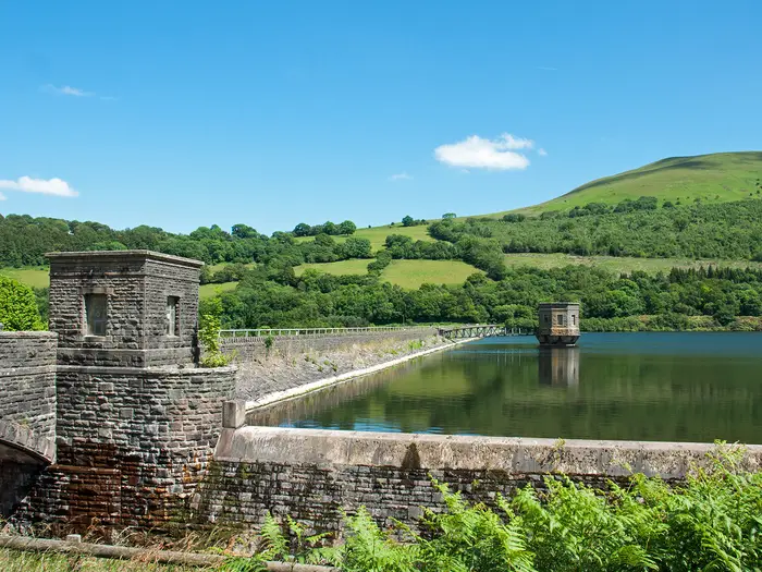
- Talybont Reservoir and Torpantau: The upland heart of the walk. The trail climbs old railway alignment to its 439 m high point at Torpantau before descending past Talybont Reservoir, with open Bannau Brycheiniog moorland views.
- Cefn Coed Viaduct: A curving 15-arch stone railway viaduct of 1866 over the Taf Fechan near Cefn-coed-y-cymmer. The route crosses it on the climb north of Merthyr Tydfil.
Challenges to expect
Do not underestimate the length or the height gain. The southern two-thirds are mostly gentle and traffic-free, but surfaces vary from tarmac to gravel and rougher forest stone. North of Merthyr Tydfil the route climbs more seriously via Pontsticill, then reaches exposed upland moor near Torpantau. Waymarking is good, but poor weather can make the high section feel remote. If you want a shorter Welsh outing, consider the Aber Falls Walk.
HikeList Score
Taff Trail scored 87/100 on HikeList's trail-quality metrics.
See score breakdownHide breakdown
- Ideal length 78
- Balanced challenge 100
- Scenery & wildness 68
- Varied terrain 100
- Accommodation 100
- Food & support 88
- Path quality 84
- Season flexibility 89
Computed from length, challenge, scenery & wildness, terrain variety, accommodation, food & support, path quality and season flexibility.
 United Kingdom
 Wales
WalesShow more data Show less
- River Valley
- Canal
- Forest
- Upland Moor
- Paved
- Gravel
- Forest Stone
- Towpath
- B&Bs
- Inns
- Hotels
- Bunkhouses
- Campsites
- Family Friendly
- Dog Friendly On Leash
- Restrooms
- Established Campsites
- Picnic Areas
- Public Transport Access Points
Download Our Full Guide to Taff Trail FREE!
Get our comprehensive guide to this hike for free. Save it for later reading or print out at home.

Photos from hikers
Taken on the trail by people who've reviewed Taff Trail.
Taff Trail: The Complete Guide
 i
Image by Jenn's Photography
i
Image by Jenn's Photography The Taff Trail is a compact but satisfying south-to-north crossing of South Wales, running 88 km from Cardiff Bay to Brecon (Aberhonddu). It suits walkers who want a well-waymarked multi-day route with strong transport links, regular valley towns and a genuine mountain finish.
The route starts beside the waterfront at Roald Dahl Plass, then follows the River Taff through Cardiff’s parks and suburbs before entering the South Wales Valleys. Riverside paths, old railway lines, canal towpaths and forest tracks carry the trail steadily inland through places such as Pontypridd, Aberfan and Merthyr Tydfil (Merthyr Tudful).
North of Merthyr, the character changes sharply. The trail climbs past Cefn Coed Viaduct, Pontsticill Reservoir and onto the exposed Torpantau pass, the high point at about 439 m, before dropping towards Talybont Reservoir and the Monmouthshire & Brecon Canal.
Most of the walk is straightforward underfoot and navigation is helped by Taff Trail markers and National Cycle Network Route 8 signs. The main commitment is distance, cumulative ascent and the upland section near Torpantau, where weather, visibility and accommodation planning matter more than they do in the southern valleys.
This guide covers stages, day planning, accommodation, food, transport, terrain and the common mistakes to avoid.
Stage-by-Stage Guide
Stage 1: Cardiff Bay to Pontypridd — 21 km
The opening stage is the easiest to organise and one of the most forgiving underfoot. It starts at Roald Dahl Plass on the Cardiff Bay waterfront, by the Celtic Ring sculpture and Wales Millennium Centre, then follows the River Taff corridor north through the city.
Expect mostly surfaced or compacted paths, riverside tracks, parkland and short road links. The route is shared with cyclists and signed as the Taff Trail and National Cycle Network Route 8 / Lôn Las Cymru, so stay alert at bends, bridges and pinch points.
The first miles pass through Grangetown / Riverside and Pontcanna, then through Bute Park beneath Cardiff Castle and past the Principality Stadium. Further north, the route passes Llandaff (Llandaf), with Llandaff Cathedral close to the trail, before continuing via Whitchurch (Yr Eglwys Newydd), Radyr and Tongwynlais.
Castell Coch is the major landmark north of Cardiff. The standard trail passes below the castle near Tongwynlais, while a steeper high-level option climbs past it; take care not to add avoidable ascent late in the stage unless there is time and energy to spare.
Food, water and toilets are easiest on this stage because the route stays close to Cardiff suburbs and Taff valley settlements. Cardiff, Radyr, Tongwynlais, Taff's Well (Ffynnon Taf) and Pontypridd all give practical options for resupply, though opening hours should still be checked if walking early, late or on a Sunday.
Pontypridd is a sensible first overnight stop, with town services and accommodation. Ynysangharad War Memorial Park makes a good end-of-stage landmark before sorting food and lodging.
Public transport is excellent. Cardiff Bay and Cardiff Central connect with the national rail network, and Taff valley stations on or near this stage include Radyr, Taff's Well and Pontypridd. This makes Stage 1 easy to shorten, delay or use as a day-walk section if needed.
Navigation is straightforward overall, but the urban setting means there are many junctions, crossings and parallel paths. Watch for Taff Trail waymarks, the stylised viaduct symbol and NCN Route 8 signs, especially where the route leaves riverside paths for short road or bridge links.
Stage 2: Pontypridd to Merthyr Tydfil — 22 km
Stage 2 continues up the Taff valley from the old bridge town of Pontypridd towards Merthyr Tydfil (Merthyr Tudful). It is still a valley walk rather than a mountain day, but the route steadily gains height and feels more industrial and post-industrial than the Cardiff approach.
The walking is generally on riverside paths, disused railway alignments, compacted surfaces and short linking sections through towns and villages. Gradients are mostly gentle, but the cumulative distance matters; this is a full day rather than a difficult one.
The route passes or runs close to Cilfynydd, Abercynon, Quakers Yard (Mynwent y Crynwyr), Aberfan, Troed-y-rhiw, Abercanaid and then Merthyr Tydfil. The valley setting gives frequent views of wooded slopes, river corridors and the old transport routes that shaped this part of South Wales.
Aberfan Memorial Garden is the most important place to allow time for. It is a place of remembrance on the site of the school destroyed in the 1966 Aberfan disaster, in which 144 people died, most of them children; visit quietly and respectfully.
Food and water are generally manageable because the stage passes through a chain of valley communities. Pontypridd and Merthyr Tydfil are the main reliable resupply points, with other settlements along the way useful for breaks if services are open.
Merthyr Tydfil is the practical overnight stop before the upland section. Accommodation and food options are stronger here than on the following mountain stage, so it is the right place to sort provisions, weather plans and an early start.
Public transport remains very useful. Stations on or near this section include Pontypridd, Abercynon, Quakers Yard, Merthyr Vale, Troed-y-rhiw, Pentre-bach and Merthyr Tydfil, giving several escape or section-walking options.
Navigation is usually helped by the old railway corridors and clear Taff Trail / NCN Route 8 signing. Take extra care through settlements, where short road links, crossings and shared-use paths can make it easier to miss a turn than on open trail.
The main warnings are practical rather than technical: shared cycling traffic, urban crossings, occasional road links and the need to keep moving over a 22 km day. If weather is poor, this stage is still far less exposed than the Torpantau crossing, but wet hard surfaces can be tiring underfoot.
Stage 3: Merthyr Tydfil to Talybont-on-Usk — 24 km
This is the key mountain stage of the Taff Trail and the one that needs the most careful planning. From Merthyr Tydfil the route climbs north through Cefn-coed-y-cymmer, Pontsarn and Pontsticill, then crosses the high point of the trail at Torpantau before descending towards Talybont Reservoir and Talybont-on-Usk.
The day begins by leaving the urban valley and climbing towards the Taf Fechan. A major landmark is Cefn Coed Viaduct, the curving 15-arch stone railway viaduct of 1866 near Cefn-coed-y-cymmer.
Beyond Pontsticill the route enters a more remote landscape. Pontsticill Reservoir and the Brecon Mountain Railway mark the transition from valley walking to the edge of Bannau Brycheiniog (the Brecon Beacons), with the trail using old railway alignment, forest tracks and rougher upland surfaces.
Torpantau pass, at about 439 m, is the high point of the route. It sits above the old Brecon & Merthyr Railway tunnel and is the most exposed part of the whole trail, with open moorland conditions that can feel very different from the sheltered valley stages.
After Torpantau the route descends past Talybont Reservoir, with some of the best mountain-and-water views on the trail. The descent is still a serious walking section in poor weather, with forest tracks, wet surfaces and rougher stone possible underfoot.
Carry sufficient food and water from Merthyr Tydfil. Pontsticill is the last settlement before the exposed upland stretch, but walkers should not rely on finding open services there without checking in advance.
Accommodation is thinner between Pontsticill and Talybont-on-Usk than in the southern valleys. The overnight stop at or near Talybont-on-Usk should be booked ahead, especially in the main walking season or if using campsites, bunkhouses or small guesthouses.
Public transport is straightforward at the start, with Merthyr Tydfil on the rail network. It is much less useful at the far end: Talybont-on-Usk has limited bus services, so times should be checked before travelling if this is being used as an access or exit point.
Navigation needs more respect here than on the first two stages. The route is still waymarked, but carry proper mapping and a reliable offline route, especially for the Pontsticill–Torpantau–Talybont section where poor visibility, forestry work or reservoir-side diversions can complicate progress. Any current forestry or reservoir diversions should be checked before travelling.
Do not treat this as just another cycle-path day. The Torpantau crossing is exposed, can be wet or wild in poor weather, and has fewer easy bail-out options than the valley sections. Waterproofs, warm layers, food, water and a realistic weather decision are essential.
Stage 4: Talybont-on-Usk to Brecon — 21 km
The final stage is gentler than the Torpantau day and follows the Monmouthshire & Brecon Canal towards Brecon (Aberhonddu). It is a scenic, practical finish after the upland crossing, with easier gradients and simpler navigation.
Most of the walking is on canal towpath, generally flatter and more even than the previous stage. Surfaces can still be wet or slippery after rain, and the towpath is shared with cyclists and local users, so keep to one side and take care on narrow sections.
From Talybont-on-Usk the route follows the canal corridor past Pencelli and Llanfrynach towards Brecon. The Brynich Aqueduct over the River Usk is one of the main landmarks before the approach into town.
Views are smaller-scale but attractive: canal water, wooded edges, valley scenery and glimpses towards the hills behind. After the exposed high ground, this stage is more about steady progress and an easy finish than major climbs.
Start with enough food and water to cover the day unless specific stops have been checked in advance. Talybont-on-Usk, Pencelli and Llanfrynach are useful places on the map, but Brecon is the main reliable service centre at the end of the trail.
Brecon has the strongest accommodation choice for the finish, with town services, inns, guesthouses and hotels. The trail finishes in the canal basin / theatre area at the head of the Monmouthshire & Brecon Canal.
Brecon has no railway station. Onward travel is by bus, with the T4 TrawsCymru running Brecon–Merthyr Tydfil–Cardiff and the T6 linking Brecon with Abergavenny rail; current timetables should be checked before booking onward trains or fixed-time connections.
Navigation is usually simple because the canal provides a clear line, but take care where the route leaves or rejoins roads, bridges and the final approach into Brecon. Continue following Taff Trail and NCN Route 8 signs until the canal basin finish rather than drifting off onto local towpath loops or road alternatives.
The main hazards are modest compared with Stage 3: shared-use towpath traffic, wet surfaces, and fatigue after several consecutive days. If walking this stage after heavy rain, allow time for slower progress on muddy or slick towpath sections.
Recommended Itinerary
The cleanest walking schedule for the Taff Trail is 4 days. It keeps the first two nights in well-served valley towns, gives the Torpantau crossing its own stage, and avoids arriving in Brecon after an unnecessarily long final day.
Book the Talybont-on-Usk night before fixing the rest of the itinerary. Accommodation and transport options are much thinner between Pontsticill, Torpantau and Talybont-on-Usk than they are in the southern valleys.
Standard 4-day itinerary
| Day | From | To | Approx. distance | Why this stage makes sense | Services/accommodation notes |
|---|---|---|---|---|---|
| 1 | Cardiff Bay | Pontypridd | 21 km | A manageable first day out of Cardiff, following the River Taff corridor through the city fringe and valley settlements. It gives enough distance without making the opening day too hard. | Cardiff has the strongest start-point services. Pontypridd is a practical overnight town, and the southern section has rail access at places such as Radyr and Taff's Well (Ffynnon Taf) if the day needs to be shortened. |
| 2 | Pontypridd | Merthyr Tydfil (Merthyr Tudful) | 22 km | A second valley stage keeps the daily distance steady and reaches the last major town before the route turns into the higher Bannau Brycheiniog terrain. | Pontypridd and Merthyr Tydfil have the best accommodation and resupply options for this part of the route. Transport for Wales stations along the valley include Pontypridd, Abercynon, Quakers Yard, Merthyr Vale, Troed-y-rhiw, Pentre-bach and Merthyr Tydfil. |
| 3 | Merthyr Tydfil (Merthyr Tudful) | Talybont-on-Usk | 24 km | This is the key committing stage: the route climbs north via Cefn-coed-y-cymmer and Pontsticill, crosses the exposed high point at Torpantau, then descends by Talybont Reservoir. Keep this day free of avoidable extra mileage. | Start early, carry proper hill kit, and check the weather before leaving Merthyr Tydfil. Accommodation around Talybont-on-Usk and the upland section should be booked ahead, and any forestry or reservoir diversions should be checked before travelling. |
| 4 | Talybont-on-Usk | Brecon (Aberhonddu) | 21 km | A gentler final stage, largely following the Monmouthshire & Brecon Canal corridor past Pencelli and Llanfrynach into Brecon. It is a sensible finish after the harder Torpantau day. | Brecon has accommodation and onward buses, but no railway station. The T4 TrawsCymru links Brecon with Merthyr Tydfil and Cardiff, while the T6 links Brecon with Abergavenny rail; current times should be checked before travelling. |
Slower 5-day option
A 5-day itinerary suits walkers who want shorter days, more time for the industrial heritage and valley sections, or a less pressured crossing into the national park. The most useful slower version is to split the Merthyr Tydfil to Talybont-on-Usk mountain stage, but only if accommodation can be secured around Pontsticill or the Pontsticill Reservoir area.
| Day | From | To | Approx. distance | Why this stage makes sense | Services/accommodation notes |
|---|---|---|---|---|---|
| 1 | Cardiff Bay | Pontypridd | 21 km | Keeps the opening day straightforward and well served. | Plenty of transport options in the southern corridor, with rail access available before Pontypridd if needed. |
| 2 | Pontypridd | Merthyr Tydfil (Merthyr Tudful) | 22 km | Reaches the main service town before the upland section. | Good place to resupply and prepare for the higher, more exposed northern stages. |
| 3 | Merthyr Tydfil (Merthyr Tudful) | Pontsticill / Pontsticill Reservoir area | Check official mapping before booking | Shortens the approach to Torpantau and avoids combining the whole upland crossing with the climb out of Merthyr Tydfil. | Only use this plan if overnight accommodation is definitely available. This should be checked before travelling. |
| 4 | Pontsticill / Pontsticill Reservoir area | Talybont-on-Usk | Check official mapping before booking | Puts the Torpantau pass and descent by Talybont Reservoir into a shorter, more weather-flexible day. | This remains the exposed mountain day, so hill clothing, food and weather awareness still matter. Book Talybont-on-Usk ahead. |
| 5 | Talybont-on-Usk | Brecon (Aberhonddu) | 21 km | Leaves a comfortable final canal stage into Brecon. | Brecon is bus-only for onward travel; check T4 and T6 times before committing to same-day connections. |
If a Pontsticill-area overnight is not available, the easier alternative is to add the extra night in the rail-served southern valley section instead, using towns such as Radyr, Taff's Well (Ffynnon Taf), Pontypridd, Abercynon or Merthyr Tydfil depending on accommodation. Distances for that version should be checked on official mapping before booking.
Faster 3-day option
A 3-day Taff Trail is possible, but it is much less balanced than the 4-day schedule. It suits fit, efficient walkers travelling light who are comfortable with one very long valley day and who do not want to make the Torpantau stage any harder than necessary.
| Day | From | To | Approx. distance | Why this stage makes sense | Services/accommodation notes |
|---|---|---|---|---|---|
| 1 | Cardiff Bay | Merthyr Tydfil (Merthyr Tudful) | 43 km | Combines the first two standard stages into one long but well-served valley day, keeping the later mountain crossing separate. | This is a big day, but it has the best fallback options because the Taff valley railway parallels much of the southern route. Accommodation and resupply are strongest at the end in Merthyr Tydfil. |
| 2 | Merthyr Tydfil (Merthyr Tudful) | Talybont-on-Usk | 24 km | Keeps the exposed Torpantau crossing as a dedicated day rather than adding it to a longer stage. | Start early and avoid this schedule in poor upland weather. Talybont-on-Usk accommodation must be arranged in advance. |
| 3 | Talybont-on-Usk | Brecon (Aberhonddu) | 21 km | Finishes with the flatter canal section into Brecon after the harder middle day. | Brecon has no rail station, so onward bus times should be checked before travelling. |
Planning the Route
Choosing a schedule
Four days is the most practical plan for most walkers. It keeps the daily stages around 21–24 km, uses the main valley towns for overnight stops, and gives enough margin for the higher, more exposed section north of Merthyr Tydfil (Merthyr Tudful).
A three-day itinerary is possible for fit walkers moving efficiently on the easier riverside, towpath and railway-path sections, but it leaves longer days and less flexibility if the weather turns on the Torpantau pass. A five-day itinerary suits walkers who want shorter days, more time in Cardiff, Pontypridd, Merthyr Tydfil or Brecon (Aberhonddu), or a gentler first multi-day walk.
| Plan | Best for | Main consideration |
|---|---|---|
| 3 days | Strong walkers, light packs, fast pace | Long days; less margin for bad weather or transport delays |
| 4 days | Most independent walkers | Natural overnight stops at Pontypridd, Merthyr Tydfil and Talybont-on-Usk |
| 5 days | More relaxed pace, sightseeing, first long-distance walk | More accommodation planning needed, especially between Merthyr and Talybont |
Natural stage breaks
The route is easiest to plan around the valley towns in the south and the canal villages in the north. A straightforward four-day split is Cardiff Bay to Pontypridd, Pontypridd to Merthyr Tydfil, Merthyr Tydfil to Talybont-on-Usk, then Talybont-on-Usk to Brecon.
The first two days are logistically forgiving, with rail stations and services close to the route through the Taff valley. The key booking pressure is the upland transition between Pontsticill, Torpantau and Talybont-on-Usk, where accommodation and services are much thinner than in Cardiff, Pontypridd or Merthyr Tydfil.
Book the mountain-side night before committing to the rest of the itinerary. For many walkers that means securing accommodation in or around Talybont-on-Usk, or another suitable stop on the Pontsticill–Talybont section, then building the walking days around it.
Fast or slow?
The Taff Trail is not technically difficult for most of its length, so a fast schedule can work if the aim is simply to complete the route. Much of the southern two-thirds follows riverside paths, disused railway alignments, towpaths and urban green corridors, which makes steady progress realistic.
Going slower is often the better plan for a first-time visit. The route has enough interest to justify extra time: Llandaff (Llandaf), Castell Coch, Pontypridd, Aberfan, Cefn Coed Viaduct, Pontsticill Reservoir, Talybont Reservoir and the Monmouthshire & Brecon Canal all reward a less rushed itinerary.
The section over Torpantau should not be squeezed into a day that leaves no weather margin. It is the high point of the trail at about 439 m and is the one part of the walk where exposure, wind, rain and low cloud can change the feel of the route quickly.
Shortening, splitting and section hiking
Section hiking is very practical on the southern half. Transport for Wales trains serve the Taff valley, with stations including Radyr, Taff's Well (Ffynnon Taf), Pontypridd, Abercynon, Quakers Yard, Merthyr Vale, Troed-y-rhiw, Pentre-bach and Merthyr Tydfil.
This makes it easy to walk Cardiff Bay to Pontypridd, Pontypridd to Merthyr Tydfil, or shorter slices between intermediate stations. It also gives useful escape options if injury, weather or time pressure affects the first half of the route.
North of Merthyr Tydfil, the route becomes less flexible. Once committed beyond Pontsticill towards Torpantau and Talybont Reservoir, there are fewer simple exit points and fewer services, so that day should be planned more carefully.
Brecon has no railway station. If finishing there, onward travel normally depends on bus services such as the T4 TrawsCymru towards Merthyr Tydfil and Cardiff, or the T6 towards Abergavenny rail. Current bus times should be checked before travelling.
Accommodation planning
Accommodation is generally easier in the populated southern valleys than in the upland middle of the route. Pontypridd, Merthyr Tydfil and Brecon have the strongest role as overnight bases, with B&Bs, guesthouses, inns and hotels.
There are also bunkhouses, campsites and a YHA in the Brecon Beacons area, but the spacing matters. Do not assume a bed will be available near the end of the Merthyr Tydfil to Talybont-on-Usk day without booking ahead.
For a four-day walk, the most important reservations are the nights after day two and day three. Merthyr Tydfil is the last major town before the exposed upland section, and Talybont-on-Usk is the natural base before the final canal approach to Brecon.
Food and water
Resupply is straightforward through Cardiff, Pontypridd, Merthyr Tydfil and the larger valley settlements, but the northern section needs more self-sufficiency. Carry enough food for the full Merthyr Tydfil to Talybont-on-Usk stage unless accommodation has arranged meals or supplies.
Water planning should be conservative on the upland day. Do not rely on finding usable water on open moorland or forestry sections; start the day with enough to cover the climb over Torpantau and the descent towards Talybont Reservoir.
On the final day, the canal towpath route through Pencelli and Llanfrynach towards Brecon is more settled, but opening hours and seasonal availability of services can still vary. This should be checked before travelling.
Navigation
The trail is waymarked with Taff Trail markers and also follows National Cycle Network Route 8 / Lôn Las Cymru signage. That makes navigation relatively simple in normal conditions, especially through the city, valley and canal sections.
Still carry mapping or a reliable offline route file. Urban edges, road links, forestry tracks and reservoir-side paths can all create junctions where a missed sign sends walkers off line. OS Explorer 151 covers the southern part around Cardiff and the valleys, while OS Explorer OL12 covers the Bannau Brycheiniog section.
The route is shared with cyclists in many places. Keep to the correct side on narrow towpaths and railway paths, and expect faster traffic on blind bends, underpasses and compacted gravel sections.
Weather and route checks
The weather check that matters most is for the Torpantau section north of Merthyr Tydfil. In poor conditions it can feel very different from the sheltered Taff valley paths: more exposed, wetter underfoot and more demanding for navigation and warmth.
Carry waterproofs, an insulating layer and a headtorch even in the main walking season. A benign forecast in Cardiff does not guarantee comfortable conditions on the pass.
Before setting off, check for any forestry, reservoir or path diversions on the Pontsticill–Talybont section. This is the part of the route where an unexpected closure can have the biggest effect on the day’s timing and accommodation plan.
Towns, Villages and Overnight Stops
For a 4-day walk, the most practical overnight pattern is usually Cardiff Bay → Pontypridd → Merthyr Tydfil → Talybont-on-Usk → Brecon. This keeps the daily distances even and puts the exposed Torpantau section between Merthyr Tydfil and Talybont-on-Usk, where accommodation is thinner and should be booked ahead.
The southern half is forgiving for logistics: the Taff valley has frequent local rail access and plenty of settlements for food and resupply. North of Merthyr Tydfil the route becomes more rural, with fewer services between Pontsticill, Torpantau, Talybont-on-Usk and the canal approach to Brecon.
Cardiff Bay
Cardiff Bay is the usual start, at Roald Dahl Plass by the waterfront, beside the Wales Millennium Centre. It is a sensible place to stay the night before the walk, especially if starting early and wanting an unhurried first day to Pontypridd.
Accommodation and food options are strongest here and in central Cardiff compared with the rest of the route. Cardiff Central and Cardiff Bay are on the rail network, so arriving without a car is straightforward.
If staying away from the immediate bay area, allow time to reach the start point before walking north through the city and into the River Taff corridor.
Grangetown / Riverside, Pontcanna, Llandaff and Whitchurch
These are early urban and suburban sections rather than natural overnight stops on a multi-day itinerary. They are useful for food, cafés and last-minute supplies before the route leaves central Cardiff behind.
Llandaff (Llandaf) is worth noting because the trail passes close to Llandaff Cathedral. Radyr, just beyond this part of the route, has a railway station and can be used as an early exit or short first-stage endpoint if splitting the trail into smaller sections.
Tongwynlais and Taff's Well
Tongwynlais sits below Castell Coch, with the trail passing beneath the castle and a steeper high-level option climbing past it. This is a useful pause point rather than a typical overnight stop.
Taff's Well (Ffynnon Taf) is more useful logistically because it has a railway station on the Taff valley line. It can work well for section walkers, or for anyone who needs to shorten the Cardiff-to-Pontypridd stage.
Food and local services should be treated as town-and-village level rather than guaranteed at all hours. Check opening times before relying on a specific stop.
Pontypridd
Pontypridd is the best first overnight stop on the standard 4-day itinerary, roughly 21 km from Cardiff Bay. It is a proper valley town with the strongest combination of accommodation, food and transport before the route continues towards Merthyr Tydfil.
Expect the usual town mix of B&Bs, guesthouses, inns and hotels, with shops and places to eat. Booking ahead is still sensible, but logistics are much easier here than on the mountain section.
Pontypridd has rail access, making it a strong start or finish point for section walking. Ynysangharad War Memorial Park and the old bridge town setting also make it a better place to stop than the smaller settlements immediately before and after it.
Cilfynydd, Abercynon and Quakers Yard
North of Pontypridd, the trail continues through the Taff valley via places such as Cilfynydd, Abercynon and Quakers Yard. These are useful for breaking up the day to Merthyr Tydfil, but they are not usually the main overnight targets for an end-to-end walk.
Abercynon and Quakers Yard both have railway stations, so this stretch is easy to adapt if weather, fatigue or timing force a change of plan. Food and resupply are more dependable in the larger valley towns, so do not leave a full day’s provisions to chance here.
Aberfan, Troed-y-rhiw and Abercanaid
This section remains in the populated valley corridor before Merthyr Tydfil. Troed-y-rhiw has a railway station, and nearby Merthyr Vale is also on the local rail network, giving further bail-out options on the approach to Merthyr.
Aberfan is an important and sensitive place on the route. The Aberfan Memorial Garden, close to the trail, deserves a respectful pause rather than being treated as a normal sightseeing stop.
For overnight planning, most walkers continue to Merthyr Tydfil rather than stopping in these smaller settlements.
Merthyr Tydfil
Merthyr Tydfil (Merthyr Tudful) is the key overnight stop before the most exposed part of the Taff Trail. On the standard itinerary it comes at the end of day 2, roughly 22 km from Pontypridd.
This is one of the main accommodation and resupply towns on the route, with B&Bs, guesthouses, inns and hotels. It is the last major place to sort food, kit issues and onward plans before the climb north towards Pontsticill, Torpantau and Talybont Reservoir.
Merthyr Tydfil has a railway station, making it a very useful access point for walkers doing only the northern half. It is also on the T4 TrawsCymru bus corridor between Cardiff, Merthyr Tydfil and Brecon, but current bus times should be checked before travelling.
Do not leave Merthyr short of food or waterproof layers. The next stage crosses the highest and most weather-exposed part of the trail.
Cefn-coed-y-cymmer, Pontsarn and Pontsticill
These places mark the transition from valley walking into the upland approach. The trail climbs north of Merthyr Tydfil, crossing the Cefn Coed Viaduct near Cefn-coed-y-cymmer and continuing towards Pontsarn and Pontsticill.
Pontsticill is the last named village before the high Torpantau section. Accommodation and services are thinner here than in the southern valleys, so it is not a place to depend on without a booking or a clear plan.
Pontsticill Reservoir and the Brecon Mountain Railway make this a good place to pause, but walkers continuing to Talybont-on-Usk should keep an eye on daylight, weather and energy levels. The route beyond is more exposed and less forgiving than the earlier valley stages.
Torpantau
Torpantau is the high point of the Taff Trail, at about 439 m on the old Brecon & Merthyr Railway alignment. It is not an overnight stop or service point; it is the exposed upland crossing between the Merthyr/Pontsticill side and the descent towards Talybont Reservoir.
Treat this section as the committing part of the walk. Carry enough food, water, waterproofs and warm layers, and check the forecast before leaving Merthyr Tydfil or Pontsticill.
If forestry, reservoir or upland diversions are in place, they can materially affect the day. This should be checked before travelling.
Talybont-on-Usk
Talybont-on-Usk is the most practical overnight stop after the Torpantau crossing and Talybont Reservoir descent. On the standard 4-day itinerary it sits at the end of the long Merthyr Tydfil to Talybont-on-Usk stage, roughly 24 km.
This is the key place to book ahead. Accommodation is more limited than in Pontypridd, Merthyr Tydfil or Brecon, and the wider Pontsticill–Talybont section has fewer options overall.
The village gives access to the Monmouthshire & Brecon Canal for the final day into Brecon. It is served by limited buses, but services should not be assumed without checking current times before travelling.
Pencelli and Llanfrynach
Pencelli and Llanfrynach sit on the easier final approach to Brecon, where the trail follows the Monmouthshire & Brecon Canal towpath for much of the way. These are useful intermediate places on the Talybont-on-Usk to Brecon stage rather than primary overnight stops for most end-to-end walkers.
They can help break up the final day if staying locally or walking a shorter itinerary, but accommodation and food should be arranged in advance rather than assumed on arrival. The final stage is much gentler logistically than the Torpantau day, but services are still more rural than in the Taff valley.
Brecon
Brecon (Aberhonddu) is the finish, at the canal basin and theatre area at the head of the Monmouthshire & Brecon Canal. It is a good final-night stop, with the strongest accommodation and food options after leaving Merthyr Tydfil.
The town has B&Bs, guesthouses, inns and hotels, and is the natural place to recover, eat properly and sort onward travel. Book ahead in busy walking seasons, especially if finishing at a weekend.
Brecon has no railway station. Onward travel is by bus: the T4 TrawsCymru runs between Brecon, Merthyr Tydfil and Cardiff, while the T6 links Brecon with Abergavenny rail. Current timetables should be checked before relying on either service.
Getting to the Start
The standard start is at Roald Dahl Plass in Cardiff Bay, by the Celtic Ring sculpture beside the Wales Millennium Centre. Cardiff is the easiest end of the Taff Trail to reach; the main planning complication is not the start, but how you will return from Brecon (Aberhonddu), which has no railway station.
By train
Use Cardiff Central as the main rail gateway. It is on the national rail network and is the most practical arrival point for walkers travelling from elsewhere in the UK.
From Cardiff Central, continue to Cardiff Bay by local public transport or taxi, then walk to Roald Dahl Plass and the Wales Millennium Centre. Cardiff Bay is also on the rail network, but services and interchange arrangements should be checked before travelling.
If you are section-hiking or need to shorten the southern half of the trail, the Taff valley is well served by Transport for Wales local trains. Useful stations along or near the route include Radyr, Taff's Well, Pontypridd, Abercynon, Quakers Yard, Merthyr Vale, Troed-y-rhiw, Pentre-bach and Merthyr Tydfil.
The key point for through-walkers is the finish: Brecon has no station. Plan the return before booking outward rail tickets, especially if walking at weekends or outside peak daytime hours.
By bus
Local buses serve Cardiff and Cardiff Bay, but specific route numbers and stop locations should be checked before travelling. For the start itself, aim for Wales Millennium Centre / Roald Dahl Plass or Cardiff Bay, then pick up the Taff Trail waymarking from the waterfront.
Longer-distance bus planning matters more at the finish. The T4 TrawsCymru service links Brecon–Merthyr Tydfil–Cardiff, and the T6 links Brecon with Abergavenny rail. Current timetables should be checked before relying on either service, particularly for a late finish in Brecon.
By car
Driving to Cardiff Bay is straightforward in general city terms, but it is not the simplest option for a point-to-point walk unless the return from Brecon has already been planned. Leaving a car in Cardiff means returning from Brecon by bus, most likely using the T4 towards Merthyr Tydfil or Cardiff, then continuing as needed.
Use city parking in Cardiff Bay or central Cardiff only after checking current long-stay rules, charges and overnight restrictions. This should be checked before travelling.
For many walkers, the cleaner arrangement is to travel to Cardiff by train, walk north, then leave Brecon by bus. If a car is essential, consider whether it is better positioned at the finish and use public transport to reach Cardiff Bay before starting; this depends on current bus times and should be checked before travelling.
From the nearest airport
If arriving by air, the practical target is still Cardiff Central or Cardiff Bay, then onward to the start at the Wales Millennium Centre. Airport-to-Cardiff public transport options and late-arrival connections change, so this should be checked before travelling.
A taxi from Cardiff Central or central Cardiff to Roald Dahl Plass is a simple fallback if local connections are inconvenient, especially for an early start or if carrying multi-day luggage.
Where to stay before starting
Stay in Cardiff Bay for the easiest morning start, particularly if you want to begin directly from Roald Dahl Plass without crossing the city first. Central Cardiff is also practical because Cardiff Central gives good rail access and easy onward travel to Cardiff Bay.
There is no need to stay outside Cardiff before starting unless you are deliberately section-hiking. For a full south-to-north walk, accommodation near Cardiff Bay or Cardiff Central keeps the first morning simple and avoids using up walking time on urban transfers.
Getting Home from the Finish
By train
Brecon (Aberhonddu) has no railway station, so every rail journey from the finish starts with a bus or taxi link out of town.
The practical rail connections are:
| Rail connection | How to reach it from Brecon | Best for |
|---|---|---|
| Merthyr Tydfil | T4 TrawsCymru bus towards Merthyr Tydfil and Cardiff | Returning down the Taff valley, or connecting with local Transport for Wales trains |
| Cardiff Central | T4 TrawsCymru bus through Merthyr Tydfil to Cardiff | Mainline rail connections across Wales and the UK |
| Abergavenny | T6 bus from Brecon to Abergavenny rail | Rail connections east and south-east from the Usk valley side |
Do not plan on simply “getting a train from the finish”. The bus leg is part of the journey and should be built into the day, especially after the final walk from Talybont-on-Usk to Brecon.
Train and bus timings need to line up, and evening connections can be the weak point. This should be checked before travelling.
By bus
The main public-transport exit from Brecon is by TrawsCymru bus.
The key services for Taff Trail walkers are:
- T4 — Brecon–Merthyr Tydfil–Cardiff
- T6 — Brecon–Abergavenny rail
The T4 is the most natural option if returning towards the Taff valley or Cardiff, as it follows the broad direction of the trail back south. The T6 is useful if Abergavenny gives better onward rail connections for your journey.
Check current times on Traveline Cymru before booking onward trains or committing to a same-day journey home. Public transport from Brecon is workable, but it is not as flexible as the rail-served southern half of the trail.
If finishing late in the day, staying in Brecon is usually the safer plan than relying on a tight final bus-and-train connection.
By car/taxi
For a point-to-point walk, avoid assuming that a car left at Cardiff Bay will be convenient at the end. If parking at the start, the return from Brecon still needs to be made by bus, train, taxi, lift, or a pre-arranged combination.
A taxi can simplify the first leg from Brecon to a railhead, or help if a bus connection has been missed, but it should not be treated as an on-demand certainty in the evening. Pre-booking is sensible, particularly at weekends, on public holidays, or after a late finish. Prices and availability should be checked before travelling.
If being collected by car, Brecon is the obvious pick-up point rather than Talybont-on-Usk or the upland section. The trail finishes in the market town around the canal basin/theatre area, so agree a clear meeting point in advance.
From the nearest airport
Air travel is not usually the limiting factor for this route; the practical issue is first getting from Brecon back to the rail network. Use the T4 towards Merthyr Tydfil/Cardiff or the T6 towards Abergavenny, then connect onwards by rail or other airport transport as required.
Airport transfers, rail connections and late-day bus links are timetable-dependent. This should be checked before travelling.
Where to stay at the finish
Brecon is a sensible place to book the final night if there is any doubt about onward transport. It avoids rushing the last canal-side stage from Talybont-on-Usk and gives more margin if the walk takes longer than expected.
Accommodation in Brecon includes the usual town options such as B&Bs, guesthouses, inns and hotels. Booking ahead is sensible in the main walking season and around busy weekends, particularly if a specific onward bus or rail connection is needed the next morning.
Which Direction Should You Walk?
The standard direction for the Taff Trail is south to north: Cardiff Bay to Brecon (Aberhonddu). This is the direction that best matches the route’s character: city waterfront, River Taff corridor, South Wales Valleys, then the open upland edge of Bannau Brycheiniog (the Brecon Beacons) before the canal-side finish in Brecon.
Walking it in reverse is perfectly possible, but it changes the feel of the route and makes the transport planning different.
Cardiff Bay to Brecon: the standard direction
Starting at Roald Dahl Plass in Cardiff Bay gives the clearest sense of progression. The early miles are urban and riverside, passing through Cardiff’s green corridor and the lower Taff valley before the route gradually becomes more industrial-valley, then upland, then canal-side into Brecon.
This direction also gives a sensible build-up. The first two days to Pontypridd and Merthyr Tydfil (Merthyr Tudful) are generally more forgiving, with strong rail access and plenty of settlements. The serious upland section over Torpantau comes later, when the route has already settled into the hills north of Merthyr Tydfil.
Transport is usually easiest at the start in this direction. Cardiff Central and Cardiff Bay are on the rail network, and the Taff valley has frequent local train options as far as Merthyr Tydfil. The main logistical drawback is at the end: Brecon has no railway station, so onward travel depends on buses such as the T4 towards Merthyr Tydfil and Cardiff or the T6 towards Abergavenny rail. Current bus times should be checked before travelling.
The finish is also stronger northbound. Arriving in Brecon by the Monmouthshire & Brecon Canal gives a clear end point in the market town, after the route has crossed its highest and wildest ground.
Brecon to Cardiff Bay: the reverse direction
Walking southbound can make sense if onward rail travel from Cardiff is the priority. Finishing in Cardiff gives far more onward transport options than finishing in Brecon, especially for walkers who need a reliable train connection at the end of the final day.
The trade-off is that the route starts with the more awkward transport leg. Reaching Brecon without a railway station means relying on bus connections before the walk begins, and this should be planned carefully. A late bus arrival can make the first walking day shorter or more pressured.
Southbound also changes the scenery progression. The route begins with the canal and the Bannau Brycheiniog approach, crosses the exposed Torpantau section early, then gradually descends into the South Wales Valleys and finally into Cardiff. That can be practical, but it gives a less satisfying “valley to mountains” build-up.
The high section is not avoided in either direction. In reverse, the climb to Torpantau comes early from the Talybont Reservoir side before the long southward descent towards Pontsticill, Cefn-coed-y-cymmer and Merthyr Tydfil. In poor weather, this exposed upland section needs the same care whichever way the route is walked.
Accommodation and staging by direction
The common four-day rhythm works naturally northbound:
| Direction | Typical flow | Planning implication |
|---|---|---|
| Cardiff Bay → Brecon | Cardiff Bay → Pontypridd → Merthyr Tydfil → Talybont-on-Usk → Brecon | Best scenery build-up; easy rail access at the start; bus required from Brecon at the end |
| Brecon → Cardiff Bay | Brecon → Talybont-on-Usk → Merthyr Tydfil → Pontypridd → Cardiff Bay | Easier rail finish in Cardiff; bus required to reach the start; upland section comes early |
Accommodation is generally more plentiful in the southern towns such as Pontypridd and Merthyr Tydfil than on the upland Pontsticill–Talybont section. That thinner mountain-side night needs booking ahead in either direction.
Recommendation
For most walkers, walk the Taff Trail south to north, from Cardiff Bay to Brecon. It is the standard direction, has the best natural progression from city and river valley to open Beacons country, and gives the most satisfying finish.
Choose the reverse only if finishing in Cardiff is more important for onward rail travel, or if accommodation availability forces the itinerary that way. In either direction, treat the Torpantau section as the key weather-dependent day and check Brecon bus times before committing to travel plans.
Accommodation Along the Route
The Taff Trail works well as an inn-to-inn or B&B-to-B&B walk, especially on the standard 4-day schedule: Cardiff Bay to Pontypridd, Pontypridd to Merthyr Tydfil, Merthyr Tydfil to Talybont-on-Usk, then Talybont-on-Usk to Brecon (Aberhonddu). The southern half is the easiest part to arrange because it passes through the Cardiff suburbs and the Taff valley towns, with rail stations close to the route at several points.
Accommodation becomes thinner north of Merthyr Tydfil (Merthyr Tudful), where the route leaves the urban valley and climbs via Cefn-coed-y-cymmer, Pontsticill and Torpantau towards Talybont Reservoir. This is the key section to plan first: the mountain-side overnight around Talybont-on-Usk or nearby villages should be booked ahead, particularly for weekends and the main walking season.
| Place | Accommodation level | Best for | Notes |
|---|---|---|---|
| Cardiff Bay / Cardiff | Good | Pre-walk night, late arrivals, flexible start | Strongest choice on the route. Useful if starting early from Roald Dahl Plass rather than travelling in on the morning of day 1. |
| Taff's Well (Ffynnon Taf) / Radyr area | Limited to moderate | Short first day or section-hiking | Useful if splitting the Cardiff to Pontypridd section. The nearby Taff valley rail stations make this stretch flexible. Availability should be checked before travelling. |
| Pontypridd | Good | Standard first overnight | The natural stop for a 4-day itinerary from Cardiff Bay, with better choice than the smaller places immediately north and south. |
| Abercynon / Quakers Yard / Troed-y-rhiw | Limited | Adjusting stage lengths, rail-based section walking | These valley settlements can help shorten or lengthen the Pontypridd–Merthyr Tydfil stage, but should not be relied on without booking. Local trains make them more useful for section-hikers than for walkers needing guaranteed beds. |
| Merthyr Tydfil (Merthyr Tudful) | Good | Standard second overnight; last major town before the upland section | The most important resupply and accommodation stop before the climb towards Pontsticill, Torpantau and Talybont Reservoir. Book here if starting the high section early the next morning. |
| Cefn-coed-y-cymmer / Pontsticill | Limited | Breaking up the Merthyr to Talybont-on-Usk stage | Accommodation is much thinner here than in the valleys. This area can be useful for walkers wanting a shorter upland day, but beds and any food arrangements should be organised in advance. |
| Torpantau | None | Not an overnight base | This is the high, exposed pass on the route rather than a service stop. Do not plan to finish a day here unless a pre-arranged pick-up or transfer is in place. |
| Talybont-on-Usk | Limited | Standard third overnight on a 4-day itinerary | The most practical stopping point after the Torpantau section, but capacity is limited compared with Pontypridd, Merthyr Tydfil or Brecon. Book early, especially at weekends. |
| Pencelli / Llanfrynach | Limited | Alternative final-night or shortened final stage | These villages on the Monmouthshire & Brecon Canal approach can work for a gentler final day into Brecon, but availability is limited and should be checked before travelling. |
| Brecon (Aberhonddu) | Good | Finish night, recovery night, onward travel base | A practical place to stay after finishing at the canal basin/theatre area. Brecon has no railway station, so onward bus plans should be checked before booking tight connections. |
Booking strategy
For a 4-day walk, secure Talybont-on-Usk or another suitable northern overnight first, then build the rest of the itinerary around it. Cardiff, Pontypridd, Merthyr Tydfil and Brecon give the most straightforward accommodation pattern; the awkwardness lies between Merthyr Tydfil and Talybont-on-Usk, where the route becomes more rural and exposed.
Advance booking is sensible throughout in spring, summer and autumn, and strongly advised for Friday and Saturday nights. The Taff Trail is shared with cyclists on National Cycle Network Route 8 / Lôn Las Cymru, so accommodation in the smaller places may be used by both walkers and cycle tourers.
Campsites, bunkhouses and hostels
The route can be planned with a mix of B&Bs, guesthouses, inns, hotels, bunkhouses, a YHA in the Brecon Beacons and campsites. This gives flexibility, but not all of these options sit exactly on the line of the trail, and the northern section has fewer choices than the urban valley stages.
If camping, use established campsites and check opening dates before committing to a stage plan. Do not assume that every village between Pontsticill, Talybont-on-Usk and Brecon has camping or bunkhouse space available on arrival.
Using taxis, trains and transfers
The southern half is easy to adjust because Transport for Wales trains serve the Taff valley, including stations at Radyr, Taff's Well, Pontypridd, Abercynon, Quakers Yard, Merthyr Vale, Troed-y-rhiw, Pentre-bach and Merthyr Tydfil. This makes it practical to stay off-route in a larger town, shorten a day, or return to a previous base for a rail-based section walk.
North of Merthyr Tydfil, transport flexibility drops sharply. Talybont-on-Usk has limited bus services and Brecon has no railway station, so any taxi transfer, luggage movement or off-route accommodation arrangement should be booked directly in advance. This should be checked before travelling.
Luggage transfer may be possible through local operators or accommodation hosts, but it should not be assumed for the whole route. Walkers relying on bag movement should arrange each stage before booking non-refundable accommodation, especially across the Merthyr Tydfil–Torpantau–Talybont-on-Usk section.
Camping and Wild Camping
The Taff Trail can be walked with camping kit, but it is better suited to planned campsite nights than to spontaneous camping. The southern half passes through Cardiff, the Taff valley towns, parks, towpaths and former railway corridors, where suitable legal pitches are limited and much of the land is urban, managed or private.
Camping becomes more realistic towards the northern end, especially around the transition from Merthyr Tydfil (Merthyr Tudful) into Bannau Brycheiniog (the Brecon Beacons) and the Monmouthshire & Brecon Canal section. Accommodation is thinner on the Pontsticill–Talybont-on-Usk stretch, so any camping or bunkhouse night here should be arranged before setting off.
Campsites and planned camping
The route has campsites in the wider corridor, alongside B&Bs, inns, hotels, bunkhouses and a YHA in the Brecon Beacons. Specific campsite availability, opening dates and whether walkers are accepted for one-night stays should be checked before travelling.
A practical camping itinerary usually needs planning around the main overnight stops rather than assuming there will be a pitch exactly on the trail each evening.
| Section | Camping practicality |
|---|---|
| Cardiff Bay to Pontypridd | Least suitable for camping. This is mainly city, parkland, riverside path and valley settlements, so accommodation or train access is usually easier. |
| Pontypridd to Merthyr Tydfil | Possible with planning, but still a populated valley section. Check campsites or indoor accommodation in advance rather than relying on finding a pitch late in the day. |
| Merthyr Tydfil to Talybont-on-Usk | The key section to plan carefully. This includes the climb past Pontsticill and over the exposed Torpantau pass, with fewer services and fewer easy fall-back options. Book the night ahead. |
| Talybont-on-Usk to Brecon | More straightforward if using arranged camping or accommodation near the Monmouthshire & Brecon Canal corridor, but do not assume towpath camping is permitted. |
Because the Taff Trail is only 88 km / 55 miles, many walkers will find that lighter accommodation-based walking is simpler than carrying a full tent, sleeping system and cooking kit. Camping makes most sense for hikers who are comfortable carrying extra weight over the Torpantau section and who have already fixed their overnight stops.
Wild camping rules and reality
Wild camping is not generally a legal right in Wales. Permission from the landowner is normally required, including in Bannau Brycheiniog. The Taff Trail also crosses or passes managed parks, canal corridors, reservoirs, forestry, farmland and private land, so camping out of sight beside the path should not be treated as acceptable by default.
The practical reality is that much of this route is poorly suited to wild camping anyway. The southern and central sections are busy, urban or semi-urban, and the northern upland section is exposed, weather-dependent and environmentally sensitive.
If seeking a permission-based wild camp, arrange it locally and keep it discreet, small and late-in/early-out. Do not camp in parks, on canal towpaths, beside reservoirs, in forestry work areas, on farmland or near buildings unless there is explicit permission.
Water and cooking
There is frequent access to towns and villages on the southern two-thirds of the route, so water should normally be topped up from shops, cafés, accommodation or other safe supplies. Do not rely on the River Taff, canals, reservoirs or upland streams as safe drinking water without treatment.
The Merthyr Tydfil to Talybont-on-Usk day needs more care. Once committed to the climb towards Pontsticill, Torpantau and Talybont Reservoir, services are thinner and the ground is more exposed, so carry enough water and food for the full upland section.
Use a stove only where it is permitted and safe. Open fires are inappropriate on this route, particularly in forestry, moorland, reservoir land and the national park; they damage ground, create wildfire risk and are rarely compatible with legal low-impact camping.
Low-impact practice
Any camping on or near the Taff Trail should follow strict Leave No Trace principles:
- use official campsites where possible;
- get landowner permission for any non-campsite pitch;
- arrive late, leave early and keep groups small;
- pitch away from paths, homes, livestock, watercourses, reservoirs and historic or memorial sites;
- take all litter out, including food waste;
- toilet well away from water, paths and buildings, and follow current local guidance;
- avoid fires completely;
- leave no flattened vegetation, food scraps or visible sign of the camp.
Seasonal considerations
Spring, summer and autumn are the normal seasons for the Taff Trail, but camping conditions still vary sharply between the valleys and the high ground. The Torpantau pass is the exposed point of the route at about 439 m, and poor weather can make this section cold, wet and slow even when the lower valley is mild.
In wet spells, towpaths, forest tracks and rougher upland ground can become muddy or slippery. In hot summer weather, carry more water before the Pontsticill–Talybont section and do not assume there will be a reliable safe refill before the next village.
For a camping-based walk, the most important planning point is simple: book or agree each night in advance, especially around the northern mountain section, and check current local rules before relying on any non-standard pitch.
Food, Water and Resupply
The Taff Trail is straightforward to resupply on its southern two-thirds, then becomes much more rural north of Merthyr Tydfil (Merthyr Tudful). Plan the route as two different walks: an urban and valley trail with frequent services as far as Merthyr, followed by a mountain-and-canal section where food and water need more deliberate planning.
Cardiff Bay, Pontypridd, Merthyr Tydfil and Brecon (Aberhonddu) are the main places to rely on for proper resupply. Smaller settlements along the Taff valley may have useful cafés, pubs, convenience shops or petrol-station food, but opening hours and exact options change, so they should be treated as bonuses rather than essential resupply points unless checked before travelling.
Food availability by section
| Section | Food availability | Water availability | Notes |
|---|---|---|---|
| Cardiff Bay to Pontypridd | Easiest section for food. Cardiff, the northern suburbs and Pontypridd have normal town services; cafés, pubs, shops and takeaways are realistic options with short diversions. | Best refilled at accommodation, cafés, pubs or public venues. Do not rely on trail-side taps. | Carry snacks and lunch if walking straight through, but this is not a remote food stage. Sunday and evening opening still need checking. |
| Pontypridd to Merthyr Tydfil | Good resupply at the stage ends. Intermediate valley settlements such as Abercynon, Quakers Yard, Aberfan and Troed-y-rhiw may offer useful local services, but do not build a plan around them without checking. | Refill in towns and at any planned café/pub stops. The River Taff is close for much of the route but should not be used untreated. | A simple plan is to leave Pontypridd with the day’s lunch and snacks, then resupply properly in Merthyr Tydfil. |
| Merthyr Tydfil to Talybont-on-Usk | The key limited-resupply stage. Merthyr Tydfil is the last major resupply before the exposed climb past Pontsticill and Torpantau. Do not assume food is available on the upland section. | Start full from Merthyr Tydfil. Natural water may be present around the reservoirs, streams and upland ground, but it should be filtered or treated if used. | Carry a full day’s food, plus emergency snacks. This is the stage where poor weather, slow going or diversions can make a shortfall more serious. |
| Talybont-on-Usk to Brecon | Rural at first, then easy at the finish in Brecon. Any services in Talybont-on-Usk, Pencelli or Llanfrynach should be checked before relying on them. | Refill before leaving Talybont-on-Usk. The Monmouthshire & Brecon Canal is not a drinking-water source. | Carry enough food and water to reach Brecon without needing a mid-stage stop. Brecon is the next dependable resupply point. |
The main resupply points
Cardiff Bay / Cardiff is the easiest place to buy food before starting. If beginning early from Roald Dahl Plass, buy breakfast, lunch and snacks the day before or allow time for city services to open.
Pontypridd makes a practical first-night resupply point on a four-day itinerary. It is large enough to plan around normal town food options rather than relying on minor trail-side stops.
Merthyr Tydfil (Merthyr Tudful) is the most important resupply point on the route. Stock up here before the climb north through Cefn-coed-y-cymmer, Pontsticill and Torpantau towards Talybont-on-Usk.
Brecon (Aberhonddu) is the finish and a reliable place to eat after the walk. It is also the place to buy onward snacks before catching buses, as there is no railway station in Brecon.
How much food to carry
For the Cardiff Bay–Pontypridd and Pontypridd–Merthyr Tydfil stages, most walkers can carry a normal hillwalking day supply: lunch, snacks and enough spare calories to cover a delay. Services are frequent enough that carrying multiple days of food is unnecessary if accommodation and evening meals are arranged in towns.
For Merthyr Tydfil to Talybont-on-Usk, leave Merthyr with all food needed until the next booked stop. This should include lunch, high-energy snacks and a reserve in case the Torpantau section is slower than expected in poor weather.
For Talybont-on-Usk to Brecon, carry enough to finish the stage without needing to buy food en route. The canal towpath is easier walking than the Torpantau stage, but rural opening hours can be limited and seasonal.
Water planning
Reliable water planning means refilling from accommodation, cafés, pubs or other staffed services whenever available. There is no need to carry excessive water through the urban valley sections, but do not assume there will be public taps directly on the trail.
The exposed northern section needs more care. Start the Merthyr Tydfil–Talybont-on-Usk stage with enough water for several hours of climbing and upland walking, especially in warm weather. If taking water from streams, reservoirs or other natural sources, filter or treat it first.
Do not drink untreated water from the River Taff, the Glamorganshire Canal remains, the Monmouthshire & Brecon Canal, reservoirs or lowland streams. Agricultural runoff, urban pollution and animal contamination are all possible along different parts of the route.
Opening hours and closures
Sunday trading, bank holidays, seasonal opening and short rural hours can affect food stops, especially north of Merthyr Tydfil and around Talybont-on-Usk. Evening arrivals are another common problem: a village with daytime options may not provide food late in the day.
Before committing to a stage plan, check opening times for any café, pub, shop or accommodation meal that forms part of the food strategy. If the plan depends on one rural stop, carry a backup meal or enough snacks to continue safely.
Terrain, Conditions and Difficulty in Practice
The Taff Trail is moderate because it is long rather than technically difficult. Most of the route uses well-made riverside paths, canal towpaths, disused railway alignments, forest tracks and short road links, with waymarking from both the Taff Trail and National Cycle Network Route 8 / Lôn Las Cymru.
The difficulty changes sharply north of Merthyr Tydfil (Merthyr Tudful). The southern two-thirds are generally gentle, sheltered and easy to shorten by train; the serious walking comes on the exposed upland section over Torpantau, where poor weather can make a straightforward route feel much more committing.
Surfaces underfoot
Expect a varied but mostly non-technical surface mix:
| Section | Typical terrain | Practical effect |
|---|---|---|
| Cardiff Bay to Pontypridd | Riverside paths, urban green corridors, parkland, compacted paths and tarmac | Fast, easy walking, but shared-use paths can be busy with cyclists and local users |
| Pontypridd to Merthyr Tydfil | River valley paths, disused railway alignments, gravel/compacted cinder, short road links | Still generally straightforward, with steady height gain up the valley |
| Merthyr Tydfil to Talybont-on-Usk | Rougher forest stone, reservoir tracks and the open upland crossing at Torpantau | The hardest part of the trail; more exposed, wetter and more weather-dependent |
| Talybont-on-Usk to Brecon | Monmouthshire & Brecon Canal towpath via Pencelli and Llanfrynach | Mostly flat and easy, though towpaths can be muddy or greasy after rain |
There is no need to treat the Taff Trail as a technical mountain route: scrambling and sustained rocky ground are not defining features. The harder surfaces are more likely to be rough forest stone, wet upland track and tired feet after long days on firm paths.
Climbs, descents and where the effort comes
The trail climbs from sea level at Cardiff Bay to the mountains, with about 1,710 m of cumulative ascent over 88 km. Much of that gain is gradual, following the River Taff valley northwards on old transport corridors that were engineered for gentle gradients.
The main exception is the climb north of Merthyr Tydfil through Cefn-coed-y-cymmer, Pontsarn and Pontsticill towards Torpantau. The high point is the Torpantau pass at about 439 m, on the old Brecon & Merthyr Railway alignment above the former railway tunnel.
This is the section to plan around. It is longer, more exposed and less forgiving than the valley miles, with fewer easy escape options and thinner accommodation on the Pontsticill–Talybont-on-Usk stretch. In poor visibility, wind or heavy rain, it can feel much more serious than the rest of the trail.
After Torpantau the route descends past Talybont Reservoir towards Talybont-on-Usk. The final day along the Monmouthshire & Brecon Canal is physically easier, but it still comes after three substantial days if using the common four-day itinerary.
Mud, weather and seasonal conditions
Spring, summer and autumn are the most practical seasons. In settled weather, the route is a well-signed valley-to-mountains walk with plenty of firm going; after prolonged rain, towpaths, forest tracks and the high section near Torpantau can become wet, slippery or slow.
The exposed upland moor at Torpantau is the main weather concern. Carry waterproofs, warm layers and a map or offline navigation even if the day begins in mild valley conditions around Merthyr Tydfil. Conditions can change quickly once the route leaves the more sheltered valley and reservoir approaches.
In hot weather, the easier southern miles can still be tiring because much of the trail is on firm surfaces such as tarmac, compacted path and gravel. Foot fatigue is a common practical issue on routes of this type, even where the gradients are gentle.
Road walking, shared use and navigation
Road walking is not the dominant character of the Taff Trail, but there are short road links between traffic-free sections. Take particular care where the route threads through towns, villages and road crossings in the Taff valley.
The route is shared with cyclists for much of its length as part of National Cycle Network Route 8 / Lôn Las Cymru. On narrower riverside paths, towpaths and bends, keep left where appropriate, listen for bikes approaching from behind and avoid walking several abreast.
Waymarking is generally a strength of the route, with Taff Trail markers and NCN signs, but urban sections can still be easy places to miss a turn because there are more junctions, bridges and side paths. The upland section deserves proper navigation backup rather than relying solely on signs.
Livestock, gates and access features
The Taff Trail is more a riverside, railway, canal, forest and moorland route than a field-to-field rights-of-way walk. Stiles and livestock fields are therefore not the main difficulty compared with many rural long-distance paths.
Access features, gates, barriers and occasional diversions can still affect progress, especially around forestry, reservoirs and shared-use infrastructure. Check for current forestry or reservoir diversions on the Pontsticill–Talybont-on-Usk section before setting out.
Weather and Best Time to Walk
The Taff Trail is best treated as a spring, summer or autumn walk. Most of the route is low-level and well-surfaced, but the character changes sharply north of Merthyr Tydfil (Merthyr Tudful), where the climb over Torpantau reaches about 439 m and becomes exposed to poor weather.
For most walkers, the most practical window is late spring to early autumn, when daylight is long enough for 21–25 km days and the upland section can be crossed without rushing. Summer gives the easiest logistics, but wet and windy days are still possible on the higher ground.
Seasonal planning
| Season | What to expect | Planning advice |
|---|---|---|
| Spring | A good walking season, with improving daylight and generally manageable temperatures. Paths can still be wet, especially on forest tracks, towpaths and the Torpantau section after poor weather. | A strong choice for a 4-day itinerary. Carry waterproofs and warm layers for the high day north of Merthyr Tydfil. |
| Summer | Best daylight and the simplest time for long days. The lower Taff valley and canal sections are straightforward in settled weather, but the route is still exposed at Torpantau. | Book accommodation ahead, especially around the thinner Pontsticill–Talybont-on-Usk section. Carry enough water between services and take sun protection for open towpath and reservoir miles. |
| Autumn | Often a good walking period, but shorter days make pacing more important. Wet leaves, mud and shaded towpaths can make surfaces slower, and upland weather can deteriorate quickly. | Start early on the Merthyr Tydfil to Talybont-on-Usk stage. Check the forecast carefully before committing to Torpantau. |
| Winter | The route is possible for well-equipped walkers in suitable conditions, but it is not the natural season for a first multi-day Taff Trail attempt. Short daylight, cold rain, wind, fog, ice or snow on the high section can make the walk much more serious. | Only plan a winter through-walk with proper winter clothing, navigation, spare time and realistic daylight stages. The Torpantau day should not be treated as a casual valley walk in poor conditions. |
The key weather risk: Torpantau
The main weather-sensitive section is the climb north of Merthyr Tydfil via Pontsticill towards Torpantau, then the descent past Talybont Reservoir. This is the highest and most exposed part of the trail, and poor visibility, strong wind or driving rain can make progress slower and navigation more demanding.
Check the mountain forecast before leaving Merthyr Tydfil or Pontsticill. If conditions are poor, the southern Taff valley has useful rail access for shortening or delaying earlier stages, but options are much thinner once committed to the Pontsticill–Talybont-on-Usk upland section.
Rain, surfaces and footwear
Much of the Taff Trail uses tarmac, compacted gravel, towpath, disused railway alignments and cycleway, so it is less boggy than many upland routes. Even so, prolonged rain can leave towpaths greasy, forest tracks rougher underfoot and the high section wet and exposed.
Waterproof footwear is sensible outside settled summer weather. Lightweight trail shoes may be adequate for experienced walkers in dry conditions, but the route is long enough that wet feet over several days can become a problem.
Heat, wind and storms
Hot weather is most likely to matter on the lower, more urban and valley sections between Cardiff Bay, Pontypridd and Merthyr Tydfil, where long stretches of hard surface can feel tiring. Carry water between towns and avoid underestimating the cumulative effect of 20 km-plus days on tarmac and compacted paths.
Thunderstorms, strong wind and low cloud are most important on the Torpantau stage. In unsettled weather, build flexibility into the itinerary rather than relying on a fixed high-level crossing at a fixed time.
Daylight and itinerary timing
A 4-day schedule gives daily stages of roughly 21–24 km, which is realistic in spring to early autumn for reasonably fit walkers. In late autumn and winter, those same distances need earlier starts and fewer delays, particularly on the Merthyr Tydfil to Talybont-on-Usk day.
The final stretch from Talybont-on-Usk to Brecon (Aberhonddu) is lower and generally easier to manage in poor weather than Torpantau, but it still takes time. Do not leave it too late in the day if relying on onward buses from Brecon; current bus times should be checked before travelling.
Accommodation and seasonal logistics
Accommodation is generally easier to arrange in the populated southern valleys than around the mountain section. The night before or after the Pontsticill–Talybont-on-Usk crossing should be booked ahead, especially in summer, at weekends and during holiday periods.
Out of the main walking season, opening days and availability can be more limited. This should be checked before travelling, particularly for bunkhouses, campsites and any accommodation outside the larger towns.
Insects and ticks
Insects are not a defining difficulty on the Taff Trail, but normal countryside precautions apply on grassy, wooded and moorland sections. Check for ticks after walking through long vegetation, especially around Pontsticill, Torpantau and Talybont Reservoir.
Seasonal closures and diversions
The Taff Trail is planned as a year-round waymarked route, but practical diversions can occur on forest, reservoir, towpath or cycleway sections. Check for current route issues before travelling, especially on the Pontsticill–Talybont-on-Usk section where a diversion can have a bigger effect on distance and timing.
Safety Notes
The Taff Trail is not a technical mountain route, but it is a long point-to-point walk with a clear change in character: urban riverside paths and valley trails in the south, then a more exposed upland crossing north of Merthyr Tydfil (Merthyr Tudful). Most safety issues come from distance, shared-use paths, changeable Welsh weather, and the more isolated Pontsticill–Torpantau–Talybont-on-Usk section.
Emergency help
In the UK, call 999 or 112 for police, fire, ambulance or mountain rescue. Ask for police, then mountain rescue if the incident is on remote or upland ground.
Mobile reception is likely to be better through Cardiff, Pontypridd and Merthyr Tydfil than on the higher and more rural northern section, but signal should not be relied on between Pontsticill, Torpantau and Talybont Reservoir. Carry an offline map, a charged phone and a power bank; on the upland day, a whistle and headtorch are sensible even for a day walk.
The main exposed section: Pontsticill to Talybont-on-Usk
The climb from north of Merthyr Tydfil past Pontsticill and over Torpantau pass is the key safety section of the route. It reaches about 439 m, is exposed to wind and rain, and can feel very different from the sheltered valley miles further south.
Check the weather forecast before leaving Merthyr Tydfil or Pontsticill, not just before the trip as a whole. In poor visibility, heavy rain or strong winds, allow extra time and be prepared to shorten the day or use transport alternatives where available. Any forestry or reservoir diversions on the Pontsticill–Talybont section should be checked before travelling.
Navigation and waymarking
The route is generally well waymarked with Taff Trail markers and National Cycle Network Route 8 / Lôn Las Cymru signs, but waymarks are not a substitute for navigation. Junctions on disused railway lines, forest tracks and canal towpaths can be easy to follow past without noticing a turn.
Carry mapping for the whole route, especially the northern half in Bannau Brycheiniog (the Brecon Beacons). OS Explorer 151 covers the southern area around Cardiff, while OS Explorer OL12 covers the Brecon Beacons section.
Shared paths and road links
Much of the Taff Trail is shared with cyclists, particularly where it follows National Cycle Network Route 8. Keep left where appropriate, avoid stopping across the full width of the path, and take care at blind bends, bridges, underpasses and canal towpath pinch points.
There are also short road links. Use pavements where present, face oncoming traffic where there is no pavement, and take extra care on bends, narrow lanes and in poor visibility.
Rivers, canals and reservoirs
The route follows the River Taff, the Glamorganshire Canal, the Monmouthshire & Brecon Canal, and passes reservoir country around Pontsticill and Talybont. Towpaths and waterside paths can be slippery after rain, with steep or unguarded edges in places.
Do not cut down reservoir banks or enter the water. Keep children and dogs close beside canals, rivers and reservoirs, particularly near bridges, locks, aqueducts and wet grass.
Weather, heat and cold
Spring, summer and autumn are the usual walking seasons, but conditions can still change quickly in the hills. Waterproofs, warm layers and a hat or gloves are sensible on the Torpantau day even when starting in mild valley weather.
In hot weather, the tarmac and compacted surfaces through the southern valleys can feel tiring over long distances. Carry enough water between towns, use sun protection, and do not underestimate the cumulative effect of 21–24 km days.
Livestock and dogs
On rural and upland sections, livestock may be encountered. Give animals space, keep dogs under close control, and put dogs on a lead where livestock are nearby or where signs require it.
Never get between cows and calves, and do not try to move sheep from the path. If threatened by cattle while walking with a dog, release the dog rather than trying to hold it close.
Solo hiking
The Taff Trail is suitable for many solo walkers, especially because the southern half has frequent settlements and rail access. The northern upland section needs more self-sufficiency: tell someone the day’s plan, expected finish point and what time to raise concern if there is no contact.
A solo walker should be able to navigate without phone signal, manage a minor injury, and keep warm if delayed. Starting the Merthyr Tydfil to Talybont-on-Usk stage early is a practical safety choice, especially outside high summer.
Check before setting off each day
Before leaving each morning, check:
- the weather forecast, especially wind, rain and visibility for the Torpantau section;
- daylight remaining for the planned stage;
- accommodation or onward transport at the end of the day;
- current bus or train times if shortening the route;
- phone battery, offline maps and power bank;
- water and food for the longest gap between services;
- any local path, forestry or reservoir diversions;
- whether the day includes road links, towpaths or shared cycle sections requiring extra care.
Gear Recommendations
The Taff Trail does not require expedition kit, but it does need more than city-walk clothing. Most of the route is on riverside paths, towpaths, disused railway lines, forest tracks and short road links, yet the Merthyr Tydfil (Merthyr Tudful) to Talybont-on-Usk stage crosses the exposed Torpantau pass at about 439 m and can feel much more mountainous in poor weather.
Footwear
Waterproof walking shoes or lightweight boots are the best fit for most walkers. The southern two-thirds include long stretches of tarmac, compacted gravel and towpath, so very stiff mountain boots can feel excessive, but trainers with poor grip are a poor choice once the route reaches wet forest stone, moorland and the Torpantau section.
If walking in a wet spell, favour footwear that handles mud, puddled towpaths and rougher tracks without becoming uncomfortable over 20 km-plus days. Spare socks are worth carrying even for inn-to-inn itineraries, especially on the Pontsticill, Torpantau and Talybont Reservoir section.
Waterproofs and warm layers
A proper waterproof jacket should be carried for the whole route, not just the Bannau Brycheiniog (Brecon Beacons) section. The lower valley miles are well served and easy to leave, but a day can still involve several hours in rain with limited shelter between towns.
For the Merthyr Tydfil to Talybont-on-Usk stage, carry a waterproof jacket, waterproof trousers or an equivalent legwear strategy, a warm mid-layer, hat and gloves in all but settled summer conditions. Torpantau is the high point of the trail and is exposed; conditions there can be markedly colder, windier and wetter than in Cardiff, Pontypridd or Merthyr Tydfil.
Navigation
The route is well waymarked with Taff Trail markers and National Cycle Network Route 8 / Lôn Las Cymru signs, but navigation should not rely on waymarks alone. Urban junctions, shared-use paths, forestry tracks and reservoir-side sections are exactly where a missed sign can add unwanted distance.
Carry offline mapping on a phone, plus a backup if walking the whole trail. The relevant OS Explorer maps are Explorer 151 for the southern section around Cardiff and the Valleys, and OS Explorer OL12 for the northern Bannau Brycheiniog section. A paper map is particularly useful north of Merthyr Tydfil, where the route becomes more remote.
A phone power bank is strongly recommended for anyone using digital mapping, train or bus information, accommodation details and photos from the same device. This matters most on the final two days, where transport options are less frequent than in the southern Taff valley and Brecon (Aberhonddu) has no railway station.
Water and food carry
The southern half passes through or near regular towns and villages including Cardiff, Taff's Well (Ffynnon Taf), Pontypridd, Abercynon and Merthyr Tydfil, so water and food can usually be managed with normal day-walk capacity. Even so, start each day with enough water to cover several hours between reliable stops.
Carry more for the Merthyr Tydfil to Talybont-on-Usk stage. The route climbs through Cefn-coed-y-cymmer, Pontsarn and Pontsticill before the exposed crossing at Torpantau and the descent by Talybont Reservoir; services are thinner here than in the Valleys. A packed lunch and spare high-energy snacks are sensible, because this is the stage where bad weather, tired legs or a navigation delay matter most.
For the final canal towpath stage from Talybont-on-Usk through Pencelli and Llanfrynach to Brecon, normal day provisions are usually adequate, but do not assume a shop or café will appear exactly when needed. Opening times and seasonal availability should be checked before travelling.
Trekking poles
Poles are optional rather than essential. The trail’s gradients are generally moderate and much of the surface is firm, but poles can help on the longer 20 km-plus days and on the climb and descent around Torpantau, especially with a heavier pack.
Use poles considerately on towpaths and shared-use sections. The Taff Trail is also used by cyclists, so keep pole tips under control on narrow paths and at blind bends.
For inn-to-inn hikers
Inn-to-inn walkers can keep packs relatively light. A 20–30 litre daypack is usually enough for waterproofs, spare warmth, food, water, navigation, first-aid basics, charging gear and overnight essentials.
Do not strip kit too far for the mountain stage. Even with accommodation booked at both ends, the Merthyr Tydfil to Talybont-on-Usk day still needs waterproofs, insulation, food, water and reliable navigation.
Useful route-specific items include:
- Lightweight footwear that is comfortable on tarmac and gravel but grippy enough for wet forest and upland paths.
- A waterproof pack liner or dry bags, as the route has long exposed sections where soaked spare layers become a problem.
- A power bank for phone navigation and onward transport checks, particularly for the Brecon finish.
- Ear awareness rather than ear isolation: shared paths with cyclists mean headphones should be used carefully, if at all.
For campers
Campers need to be more selective than on a remote mountain trail, because the Taff Trail mixes urban corridors, villages, towpaths, reservoirs, forest and national park terrain. Use recognised campsites or booked camping where available; do not assume informal camping is acceptable along canals, reservoirs, parks or forestry land.
A compact three-season camping setup is the practical choice in spring, summer and autumn: tent or shelter, sleeping bag, mat, stove if needed, waterproof storage and enough warm clothing for a damp evening. The upland section near Pontsticill, Torpantau and Talybont Reservoir can be wet and windy, so a shelter should be stable enough for exposed Welsh weather rather than chosen solely for low weight.
Food planning matters more for campers on the northern half. The southern valleys provide better resupply opportunities, while the Pontsticill–Talybont section is thinner for services and should be treated as a carry-through day.
For fast walkers and section hikers
Fast walkers can travel light on the southern sections by using the strong rail access along the Taff valley. Stations at places such as Radyr, Taff's Well, Pontypridd, Abercynon and Merthyr Tydfil make it realistic to split or shorten days without carrying overnight gear.
A minimalist pack should still include waterproofs, warm layer, water, food, offline mapping, phone power and a small first-aid kit. The route is well signed, but shared urban paths and cycle-route junctions are not the place to depend on memory alone.
For the Merthyr Tydfil to Talybont-on-Usk section, avoid treating the stage like a lowland railway-path run. Torpantau is the trail’s exposed high point and the escape options are less convenient than in the Valleys; carry enough clothing and charge to slow down safely if weather or fatigue changes the plan.
Sun, insects and seasonal extras
In spring and autumn, add gloves, hat and an extra warm layer for the high section, even if the start of the route feels mild. Daylight is also shorter, so a small headtorch is sensible for any long stage or late arrival.
In summer, carry sun protection, enough water and a light layer for wind on the open ground. Insect repellent can be useful around wooded, waterside and reservoir sections, especially on still days.
Winter-specific equipment is not the normal basis for this route as described here, which is best suited to spring, summer and autumn. If walking outside those seasons, weather, daylight, ground conditions and transport should be checked before travelling, and kit should be upgraded accordingly.
Budget and Costs
The Taff Trail can be walked cheaply because it passes through sizeable towns for much of its length and has strong rail access in the south. Costs rise on the northern half, where accommodation is thinner between Merthyr Tydfil (Merthyr Tudful), Pontsticill, Talybont-on-Usk and Brecon (Aberhonddu), and where taxis may be needed if buses do not fit the walking plan.
All figures below are practical planning estimates in GBP. Accommodation, food and transport prices change frequently, especially at weekends, during school holidays and in good-weather periods, so current prices should be checked before booking.
Typical daily budgets
| Style | Likely spend per person, per day | What it usually means |
|---|---|---|
| Budget | £35–£65 | Camping, bunkhouse or hostel-style stays where available; supermarket food and simple café/pub stops; minimal taxi use |
| Mid-range | £80–£140 | B&Bs, guesthouses or inns; breakfast included where possible; one pub/café meal a day; public transport at either end |
| Comfortable | £140–£220+ | Better rooms or hotels, more meals out, private transfers or taxis to simplify the Pontsticill–Talybont/Brecon logistics |
For a practical 4-day / 3-night itinerary, excluding travel to Cardiff and home from Brecon, a realistic overall spend is often around:
| Style | 4-day estimate |
|---|---|
| Budget | £140–£260 |
| Mid-range | £320–£560 |
| Comfortable | £560–£900+ |
Accommodation costs
Accommodation is the biggest variable. Cardiff, Pontypridd, Merthyr Tydfil and Brecon offer the broadest choice, while the upland night around Pontsticill, Talybont-on-Usk or nearby villages is the one most worth booking early.
Typical planning ranges:
| Accommodation type | Typical cost guidance |
|---|---|
| Campsite pitch | £10–£25 per person |
| Bunkhouse / hostel-style bed | £20–£45 per person |
| B&B / guesthouse | £60–£110 for a single room; £80–£150 for a double/twin room |
| Inn / hotel | £100–£180+ per room |
Camping can make the Taff Trail much cheaper, but it is less straightforward than on routes with regular rural campsites every stage. The southern half is more urban, and the mountain section north of Merthyr Tydfil has fewer convenient overnight options, so pitches and bunkhouse beds should be arranged before setting out.
Food and drink
The southern two-thirds of the route are good for resupply, with towns and villages such as Cardiff, Pontypridd and Merthyr Tydfil breaking up the walk. This keeps food costs manageable, especially if carrying supermarket supplies rather than relying on pubs and cafés.
Allow roughly:
| Food style | Typical daily cost |
|---|---|
| Mostly self-catered food and snacks | £10–£20 |
| Mixed supermarket food plus café/pub stops | £20–£40 |
| Pub meals, cafés and drinks throughout | £40–£60+ |
Carry enough food and water for the Merthyr Tydfil to Talybont-on-Usk stage. That day crosses the exposed Torpantau section and has fewer easy resupply points than the valley stages.
Transport costs
Cardiff is the easiest end of the route for public transport. Cardiff Central and Cardiff Bay are on the rail network, and the Taff valley has frequent local trains at places including Radyr, Taff's Well, Pontypridd, Abercynon, Quakers Yard, Merthyr Vale, Troed-y-rhiw, Pentre-bach and Merthyr Tydfil.
Brecon has no railway station. Most walkers leaving the finish use the T4 TrawsCymru bus towards Merthyr Tydfil and Cardiff, or the T6 towards Abergavenny rail. Current bus times and fares should be checked before travelling, particularly on Sundays and public holidays.
A budget-conscious walker can keep transport costs low by using trains and buses throughout. The main cost risk is needing a taxi from Talybont-on-Usk, Pontsticill or another northern point if accommodation, weather or bus times do not line up.
Taxis, luggage transfer and packages
Local taxis are useful as a fallback, not something to rely on without booking. They are most relevant around the northern section, where public transport is more limited and accommodation is more spread out than in the Taff valley.
Dedicated luggage transfer should not be assumed across the whole route. This should be checked before travelling. If luggage transfer is essential, arrange it before booking accommodation, as the Pontsticill–Talybont-on-Usk section is the part most likely to create complications.
Self-guided packages may be available through walking-holiday companies, but prices vary widely with room standard, luggage arrangements and whether transport is included. Compare any package against the real cost of booking B&Bs, buses and trains independently; on the Taff Trail, independent planning is very feasible for walkers comfortable arranging their own accommodation.
Luggage Transfer, Guided Tours and Support Services
Luggage transfer
Do not assume the Taff Trail has the same established end-to-end baggage-transfer network as busier UK National Trails. If walking it inn-to-inn, the safest approach is to contact accommodation in Cardiff, Pontypridd, Merthyr Tydfil, Talybont-on-Usk and Brecon before booking and ask whether they can arrange or recommend local luggage movement.
This matters most for the Merthyr Tydfil to Talybont-on-Usk stage. Accommodation and services are thinner around Pontsticill, Torpantau and Talybont Reservoir, and the high section over Torpantau is the one part of the route where carrying a heavy overnight pack can make a moderate day feel significantly harder.
If using luggage transfer, agree the following in writing:
- exact collection and delivery addresses, especially for rural stays near Talybont-on-Usk;
- bag limits and labelling requirements;
- latest drop-off time each morning;
- whether delivery is to reception, a locked store or a pre-arranged safe place;
- what happens if weather or forestry/reservoir works affect access on the Pontsticill–Talybont section.
Prices, availability and seasonal coverage vary, so confirm current details before booking.
Self-guided packages
A self-guided package can suit walkers who want the route split, accommodation booked and luggage arrangements handled in one place. For the Taff Trail, the most useful package would normally cover a 3–5 day south-to-north itinerary from Cardiff Bay to Brecon, with overnight stops such as Pontypridd, Merthyr Tydfil and Talybont-on-Usk.
Before paying a deposit, check exactly what is included. Useful inclusions are accommodation, daily route notes or GPX files, baggage movement, emergency contact arrangements and advice for leaving Brecon at the end, as Brecon has no railway station.
A package is less necessary for confident walkers using public transport and booking their own rooms. The southern half is well supported by Taff valley trains, with stations including Radyr, Taff's Well, Pontypridd, Abercynon and Merthyr Tydfil, so it is straightforward to shorten or split stages there.
Guided walking
Most walkers do not need a guide for the full Taff Trail. It is waymarked, follows National Cycle Network Route 8 / Lôn Las Cymru for much of its length, and passes through regular towns and villages in the southern valleys.
Guided support may still be worthwhile for groups, less confident walkers, corporate charity teams or anyone unfamiliar with upland navigation. The section north of Merthyr Tydfil, climbing past Pontsticill to the Torpantau pass and descending towards Talybont Reservoir, is the obvious place to consider professional support in poor weather.
If booking a guide, make sure the arrangement is specific to the walking route, not just a general sightseeing tour. The guide should be comfortable with Bannau Brycheiniog upland conditions, shared-use trail etiquette and contingency planning for the exposed Torpantau section.
Taxi transfers and public-transport backup
Local taxis are most useful for the gaps between the trail and rural accommodation, or for shortening the Merthyr Tydfil to Talybont-on-Usk day if weather, fatigue or timing become an issue. Book rural taxi moves ahead rather than relying on availability at the end of the day, particularly around Pontsticill, Talybont-on-Usk and Brecon.
The southern half has strong public-transport backup. Transport for Wales local trains serve the Taff valley, making it practical to leave or rejoin the route at places such as Pontypridd, Abercynon or Merthyr Tydfil.
The finish needs more planning. Brecon has no railway station, so onward travel is by bus or pre-booked taxi. The T4 TrawsCymru runs Brecon–Merthyr Tydfil–Cardiff, and the T6 links Brecon with Abergavenny rail; current timetables should be checked before travelling.
What to book ahead
Book the mountain-side night first, especially if staying in or near Talybont-on-Usk after the Torpantau stage. Accommodation is more limited here than in Cardiff, Pontypridd or Merthyr Tydfil.
Also book any luggage movement, rural taxi transfers and finish-day onward travel before starting. The route is easy to organise independently in the south, but the upland middle and the bus-only finish at Brecon reward firmer planning.
Shorter Hikes and Best Sections
The Taff Trail is unusually easy to shorten in its southern half because the Taff valley railway shadows much of the route. North of Merthyr Tydfil (Merthyr Tudful), options become more limited: the trail crosses the exposed Torpantau pass, Talybont-on-Usk has limited buses, and Brecon (Aberhonddu) has no railway station.
| Best for | Start and end | Approx distance | Why choose it | Transport notes |
|---|---|---|---|---|
| Best day walk | Talybont-on-Usk to Brecon (Aberhonddu) | 21 km | The most relaxed showcase day: Monmouthshire & Brecon Canal towpath, Pencelli, Llanfrynach, the Brynich Aqueduct over the River Usk and a simple finish in Brecon. It avoids the exposed Torpantau climb while still giving a strong Bannau Brycheiniog finish. | Talybont-on-Usk has limited buses; Brecon has no station. Use the T4 towards Merthyr Tydfil/Cardiff or the T6 towards Abergavenny rail from Brecon. Times should be checked before travelling. |
| Best weekend section | Merthyr Tydfil to Brecon via Talybont-on-Usk | 45 km | The strongest two-day version of the trail: railway heritage, Cefn Coed Viaduct, Pontsticill Reservoir, the climb over Torpantau, Talybont Reservoir, then the canal into Brecon. This gives the full valley-to-mountains character without walking the urban southern approach. | Start by train at Merthyr Tydfil. Finish by bus from Brecon, using the T4 to Merthyr Tydfil/Cardiff or the T6 to Abergavenny rail. Book the night around Talybont-on-Usk or the upland section ahead, as accommodation is thinner here. |
| Best 3-day section | Pontypridd to Brecon | 67 km | A compact version of the full route, starting in the South Wales Valleys and continuing through Merthyr Tydfil, Torpantau and the canal approach to Brecon. It keeps the industrial heritage, the mountain crossing and the final towpath, while skipping the Cardiff approach. | Pontypridd is on the Taff valley rail network. Brecon is bus-only, with onward links by T4 to Merthyr Tydfil/Cardiff or T6 to Abergavenny rail. Current bus times should be checked before booking. |
| Best scenery | Merthyr Tydfil to Talybont-on-Usk | 24 km | The most dramatic stage: Cefn Coed Viaduct, Pontsticill Reservoir, open moorland around Torpantau and the descent past Talybont Reservoir. It is also the hardest short section, with the trail’s high point at about 439 m and exposed weather on the pass. | Merthyr Tydfil has rail access. Talybont-on-Usk has limited buses, so this section needs more planning than the southern valley stages. Do not rely on a late escape from the upland section. |
| Best for beginners | Cardiff Bay to Pontypridd | 21 km | The easiest introductory full day, following the River Taff corridor from Roald Dahl Plass through central Cardiff, Bute Park, Llandaff (Llandaf), Tongwynlais and Taff’s Well (Ffynnon Taf). It is long, but gradients are gentler than the northern mountain section and there are frequent places to shorten the day. | Cardiff Bay and Cardiff Central are on the rail network. Useful rail access along or near this southern section includes Radyr, Taff’s Well and Pontypridd. If 21 km is too much, plan a shorter station-to-station walk instead. |
| Best for public transport | Pontypridd to Merthyr Tydfil | 22 km | A practical valley day with multiple rail access points, passing places such as Abercynon, Quakers Yard, Aberfan, Troed-y-rhiw and Abercanaid before Merthyr Tydfil. It is one of the easiest sections to shorten if pace, weather or daylight become an issue. | Transport for Wales local trains serve Pontypridd, Abercynon, Quakers Yard, Merthyr Vale, Troed-y-rhiw, Pentre-bach and Merthyr Tydfil. Check current services before travelling. |
| Best for towns, services and accommodation | Cardiff Bay to Merthyr Tydfil over two days | 43 km | The most convenient short multi-day option, with Pontypridd making a natural overnight stop. Food, accommodation and rail options are far more plentiful here than on the Pontsticill–Talybont upland section. | Rail access is strong throughout this southern half, with Cardiff, Pontypridd and Merthyr Tydfil all straightforward start or finish points. |
| Best for camping-style planning | Merthyr Tydfil to Brecon via Talybont-on-Usk | 45 km | This is the best short section if the aim is to combine the mountain crossing with a night near the northern half of the trail. It needs careful planning because accommodation and camping options are thinner around the Pontsticill–Talybont section than in the valleys. | Start by rail at Merthyr Tydfil and leave Brecon by bus. Book campsites or other overnight stops in advance; availability and access should be checked before travelling. |
For a very short half-day walk, the southern railway-served corridor is the sensible place to plan it. Choose two stations on the Taff valley line — for example around Radyr, Taff’s Well, Pontypridd, Abercynon or Merthyr Tydfil — and check the walking distance on a current map before setting off.
The northern half should not be treated as an easy station-to-station route. Once north of Merthyr Tydfil, the trail becomes more committing, especially over Torpantau, and public transport options are much less forgiving.
Highlights and Points of Interest
The Taff Trail is at its best when treated as a journey from city waterfront to upland pass, rather than just a signed line between Cardiff and Brecon. The most rewarding places to slow down are the early Cardiff riverside section, Castell Coch, Pontypridd, Aberfan, the Cefn Coed Viaduct and the whole mountain section from Pontsticill over Torpantau to Talybont Reservoir.
Cardiff Bay, the River Taff and Bute Park
The usual start at Roald Dahl Plass puts the trail on the waterfront beside the Wales Millennium Centre and the Celtic Ring sculpture. It is a distinctive urban start, but the route soon settles into the River Taff corridor.
North of the bay, the trail passes the Principality Stadium area and then runs through Bute Park beneath Cardiff Castle. This is one of the easiest places on the route to linger without affecting logistics, as Cardiff has excellent transport and services.
Llandaff Cathedral
Llandaff (Llandaf) Cathedral is one of the main early historic sights on the walk out of Cardiff. It sits close to the riverside miles and is worth allowing time for if starting with a shorter first day.
This is also a useful point at which the route begins to feel less like a city walk and more like a green corridor northwards along the Taff.
Castell Coch and Tongwynlais
Castell Coch is one of the most recognisable landmarks on the southern half of the trail. The 19th-century Gothic Revival “Red Castle” stands above Tongwynlais, built by William Burges for the 3rd Marquess of Bute on medieval foundations.
The main trail passes below it, while a steeper high-level option climbs past the castle. Walkers with time and energy should consider the higher line, especially in clear weather, but it adds effort compared with staying on the easier valley route.
Pontypridd and Ynysangharad War Memorial Park
Pontypridd is one of the best overnight stops on the southern half and a natural place to break the route. The town sits on the River Taff and has the practical advantage of services and rail access.
Ynysangharad War Memorial Park gives a pleasant riverside pause in the centre of the town. Pontypridd is also notable as the birthplace town of the Welsh national anthem, adding a strong cultural stop to what is otherwise a very practical valley stage.
Aberfan Memorial Garden
Aberfan Memorial Garden is one of the most important stops on the trail, and should be approached as a place of remembrance rather than a sightseeing detour. It stands on the site of the school destroyed in the 1966 Aberfan disaster, in which 144 people, mostly children, died.
It is close to the route and is worth a respectful pause, particularly on the Pontypridd to Merthyr Tydfil section. Allow quiet time here rather than treating it as a brief photo stop.
Merthyr Tydfil and the shift into the Beacons
Merthyr Tydfil (Merthyr Tudful) marks a clear change in the character of the Taff Trail. South of here the walking is mostly valley, riverside, railway and urban-edge greenway; north of here the route begins to climb towards reservoirs, forest and open Bannau Brycheiniog moorland.
For many walkers this is the most important planning divide on the route. Merthyr has rail access and services, while the next section towards Pontsticill, Torpantau and Talybont-on-Usk is more committing and accommodation is thinner.
Cefn Coed Viaduct
The Cefn Coed Viaduct is one of the trail’s strongest industrial heritage features. This curving 15-arch stone railway viaduct, built in 1866, crosses the Taf Fechan near Cefn-coed-y-cymmer.
It comes on the climb north of Merthyr Tydfil and is a good place to appreciate how much of the Taff Trail reuses old railway infrastructure. It also signals the start of the more dramatic northern half.
Pontsticill Reservoir and the Brecon Mountain Railway
Pontsticill Reservoir sits at the foot of the Beacons and makes a natural pause before the climb towards Torpantau. The setting is quieter and more upland in feel than the southern valleys, with water, forest and open hills beginning to dominate the route.
The Brecon Mountain Railway runs beside this part of the trail on a narrow-gauge heritage steam line climbing towards Torpantau. It can be treated as an optional local-interest stop, but operating days and times should be checked before planning around it.
Torpantau Pass
Torpantau is the high point of the Taff Trail, at about 439 m, and the most exposed part of the whole walk. The route follows the old Brecon & Merthyr Railway alignment above the highest standard-gauge railway tunnel in Britain, around 1,313 ft / 400 m.
In good weather this is one of the finest sections, with open Bannau Brycheiniog moorland views and a strong sense of crossing from the industrial valleys into the mountain landscape. In poor weather it can feel bleak, wet and exposed, so it is the one highlight on the route that also demands the most respect.
Talybont Reservoir
The descent from Torpantau towards Talybont Reservoir is one of the scenic rewards of the trail. The reservoir lies below the pass, ringed by forest and moor, and gives some of the best views on the route.
This is a good area to slow the pace if the day’s accommodation allows it. The Pontsticill–Talybont section is less well supplied than the southern valley stages, so extra time here needs to be balanced against booked accommodation and weather conditions.
Monmouthshire & Brecon Canal to Brecon
The final stretch from Talybont-on-Usk to Brecon (Aberhonddu) follows the Monmouthshire & Brecon Canal towpath. After the exposed crossing at Torpantau, this section is gentler, flatter and more settled.
The route passes Pencelli and the Brynich Aqueduct over the River Usk before reaching Brecon at the canal basin and theatre area. It is the best part of the trail for an unhurried final day, especially for walkers who want a softer finish after the mountain stage.
Best places to allow extra time
| Place | Why linger |
|---|---|
| Cardiff Bay and Bute Park | Strong start, easy services, riverside walking and major Cardiff landmarks. |
| Llandaff (Llandaf) | Cathedral stop on the early green corridor out of the city. |
| Castell Coch | Major visual landmark above Tongwynlais, with a steeper high-level option. |
| Pontypridd | Practical overnight town, riverside park and Welsh national anthem connection. |
| Aberfan | Important memorial garden requiring a respectful pause. |
| Cefn Coed Viaduct | Impressive railway heritage feature on the climb north of Merthyr Tydfil. |
| Pontsticill and Torpantau | Reservoir, heritage railway interest and the route’s exposed upland high point. |
| Talybont Reservoir | One of the most scenic reservoir-and-moorland sections. |
| Monmouthshire & Brecon Canal | Easy, attractive final approach through Pencelli and into Brecon. |
Common Mistakes and Planning Tips
The Taff Trail is not technically hard for most fit walkers, but it is easy to mis-plan because the route changes character so sharply: city parks and valley railway paths in the south, then a more remote upland crossing over Torpantau before the canal approach to Brecon. The mistakes below are the ones most likely to affect a walking itinerary.
| Common mistake | Better plan |
|---|---|
| Treating the whole trail like an easy riverside path | Plan for a full 88 km / 55 miles with about 1,710 m of ascent, including the exposed high point at Torpantau, around 439 m. |
| Leaving the Pontsticill–Talybont-on-Usk night vague | Book accommodation ahead for the mountain section, where options are thinner than in Cardiff, Pontypridd, Merthyr Tydfil and Brecon. |
| Assuming Brecon has a railway station | Brecon has no station. Plan the finish around buses: the T4 runs Brecon–Merthyr Tydfil–Cardiff and the T6 links Brecon with Abergavenny rail. Current times should be checked before travelling. |
| Overloading the first two days with kit and food | Use the strong southern rail corridor and town services sensibly. The harder food-and-water planning comes north of Merthyr Tydfil, especially over the upland section. |
| Relying only on Taff Trail and NCN 8 signs | Carry mapping or a reliable offline route file as well. OS Explorer 151 covers the southern section and OS Explorer OL12 covers Bannau Brycheiniog. |
| Forgetting that this is a shared-use route | Expect cyclists on National Cycle Network Route 8 / Lôn Las Cymru, especially on traffic-free tarmac, railway paths and towpaths. Keep to one side and take care at bends and bridges. |
| Planning the Torpantau day without checking the weather | Check the Bannau Brycheiniog forecast before committing to the high section. In poor weather, the old railway alignment over Torpantau can feel much more serious than the southern valley miles. |
| Treating every settlement name on the map as a guaranteed resupply stop | Cardiff, Pontypridd, Merthyr Tydfil and Brecon are the safest service bases. Smaller places and upland villages should not be relied on without checking current opening times. |
| Using old route notes without checking for changes | Check for current forestry or reservoir diversions on the Pontsticill–Talybont-on-Usk section before setting off. This is the part where a diversion has the biggest impact on time and effort. |
Do not underestimate the Merthyr Tydfil to Talybont-on-Usk day
On a four-day schedule, the third stage from Merthyr Tydfil (Merthyr Tudful) to Talybont-on-Usk is the key planning day. It is roughly 24 km, includes the climb north through Cefn-coed-y-cymmer, Pontsarn and Pontsticill, and crosses the high ground at Torpantau before descending towards Talybont Reservoir.
This is the day to start with a charged phone, offline mapping, waterproofs, warm layers and enough food and drink to be comfortable between reliable services. It is also the day most affected by wind, rain, low cloud or forestry and reservoir diversions.
Keep the transport plan realistic
The southern half is forgiving because the Taff valley has frequent local rail access, including stations such as Radyr, Taff's Well (Ffynnon Taf), Pontypridd, Abercynon, Quakers Yard, Merthyr Vale, Troed-y-rhiw, Pentre-bach and Merthyr Tydfil. This makes it easy to shorten a day, abandon in bad weather or walk the trail in sections.
The northern end is different. Brecon (Aberhonddu) is bus-only, and Talybont-on-Usk has limited buses. Do not leave the return journey as an afterthought: check current T4 and T6 times before booking onward trains or accommodation.
Book the right places, not just the cheapest places
Accommodation is much more plentiful in the populous southern valleys than around the upland middle of the route. A cheap room that forces a long off-route detour can turn a moderate walking day into an awkward one, especially after the Torpantau crossing.
For a four-day walk, the natural service centres are Pontypridd, Merthyr Tydfil, Talybont-on-Usk and Brecon. If changing the itinerary, check whether the revised overnight stop still leaves a sensible next day over or around the high section.
Check the route, not just the headline distance
The Taff Trail is often described as a largely traffic-free, well-waymarked route, which is true, but that does not mean it is navigation-free. The route links riverside paths, canal towpaths, disused railways, forest tracks and short road sections, so a missed sign can send you onto the wrong parallel corridor.
Use the waymarks as the primary on-the-ground guide, but keep an offline map available for junctions, urban edges and the forested reservoir sections. A GPX file is useful, but any route file should be checked against current information before use.
Plan stages around daylight and fatigue
A practical four-day itinerary gives days of about 21–24 km, which is manageable for many walkers but still a sustained pace over multiple days. A three-day itinerary compresses the route significantly and is better suited to strong walkers who are comfortable with long consecutive days.
If unsure, use the rail-accessible southern half to make the first two days flexible rather than forcing an over-long start. Saving energy for Merthyr Tydfil to Talybont-on-Usk is a better strategy than arriving at the upland section tired.
Final Advice
The Taff Trail is best suited to walkers who want a manageable first multi-day route with strong waymarking, frequent services in the southern valleys and a clear sense of progression from city riverside to open upland. It is also a good section-hike: the rail-served stretch between Cardiff, Pontypridd and Merthyr Tydfil makes it easy to walk in shorter pieces or bail out if needed.
The main planning priority is the Merthyr Tydfil to Talybont-on-Usk stage. This is where the route leaves the more forgiving valley infrastructure, climbs past Pontsticill and crosses the exposed high point at Torpantau before descending towards Talybont Reservoir. Book accommodation for this mountain-side night ahead, carry proper waterproofs and warm layers, and check the forecast carefully before committing to the crossing.
The most rewarding part of the route is the northern half: Cefn Coed Viaduct, Pontsticill Reservoir, the old railway alignment over Torpantau, Talybont Reservoir and the final Monmouthshire & Brecon Canal towpath into Brecon. That said, the southern stages are not just approach miles — the River Taff corridor, Llandaff (Llandaf), Castell Coch and Pontypridd give the walk much of its character.
For most walkers, four days is the most balanced way to complete the full 88 km / 55 miles. A three-day schedule is possible for fit walkers happy with longer days, while five days gives more time for Cardiff, Pontypridd, Merthyr Tydfil and Brecon without turning the upland day into a rush.
Do not treat the Taff Trail as only a riverside cycle path. Much of it is straightforward, but the combination of 1,710 m of ascent, shared-use paths, mixed surfaces and one exposed upland crossing means it still needs proper walking footwear, navigation backup and weather-aware planning.
The finish also needs thought: Brecon (Aberhonddu) has no railway station. Plan onward travel by bus before setting out, especially if using the T4 towards Merthyr Tydfil and Cardiff or the T6 towards Abergavenny rail. Current timetables should be checked before travelling.
Beginning in the lively surrounds of Cardiff Bay, this section heads north alongside the River Taff, skirting the Millennium Stadium and through the city’s central parks, including the picturesque Bute Park. The trail follows a mostly flat and well-paved route past Llandaff Cathedral, then transitions into quieter suburban stretches through Radyr and towards the historic woodland below Castell Coch. The route then opens into the Taff Valley, passing through Taff's Well and onto the town of Pontypridd, offering river and woodland views throughout.
Leaving Pontypridd, the trail continues north, initially following former railway routes and canal paths, passing through former mining villages such as Abercynon and Aberfan. Rising slightly in elevation, it features a mixture of surfaced and compacted gravel paths, providing expansive views across the South Wales Valleys. Approaching Merthyr Vale, the route gradually ascends, culminating in Merthyr Tydfil, a town rich in industrial heritage and the halfway point of the Taff Trail.
From Merthyr Tydfil, the trail heads into the Brecon Beacons National Park, following the Taf Fechan river and passing near Cyfarthfa Castle and the peaceful Pontsticill Reservoir. The path here becomes more rural and undulating, crossing sections of open moorland, woodland, and old tram roads. Significant points of interest include the reservoirs of Pontsticill and Talybont, as well as the scenic Brecon and Monmouthshire Canal. The final stretch leads hikers alongside the canal towpath into the historic market town of Brecon, completing the route.
Reviews
How would you rate Taff Trail?
Tap a star to start your review — you could be the first.