Štefánikova Magistrála
How would you rate Štefánikova Magistrála?
Tap a star to share your experience and help other hikers.
Štefánikova Magistrála: Little Carpathians Hiking Guide
HikeList Score
Štefánikova Magistrála scored 75/100 on HikeList's trail-quality metrics.
See score breakdownHide breakdown
- Ideal length 78
- Balanced challenge 84
- Scenery & wildness 66
- Varied terrain 100
- Accommodation 58
- Food & support 65
- Path quality 81
- Season flexibility 89
Computed from length, challenge, scenery & wildness, terrain variety, accommodation, food & support, path quality and season flexibility.
Štefánikova Magistrála is an around 120 km point-to-point trail through the Little Carpathians (Malé Karpaty) in western Slovakia. It is usually walked in 4 hard days, with roughly 4,759 m of cumulative ascent and long, hilly forest sections rather than high alpine terrain. It suits fit hikers who can navigate with maps, arrange their own village accommodation or camping, and handle patchy waymarking. For a bigger Slovak thru-hike, compare the Cesta Hrdinov SNP.
Route Overview
The official route is defined between the Štefánik Memorial near Ivanka pri Dunaji, beside Bratislava airport, and the Bradlo mausoleum above Brezová pod Bradlom. A widely walked variant starts at Devín Castle on the edge of Bratislava; both versions finish at Bradlo. The Devín variant passes Devínska Kobyla and Sandberg, Kamzík, Pezinská Baba, Biely kríž, Záruby, Ostrý Kameň, Dobrá Voda and Brezová pod Bradlom. The trail follows red and green tourist markings and shares its early section with the European long-distance path E8. Plan end-to-end transport around Bratislava/Ivanka pri Dunaji or Devín, and Brezová pod Bradlom. For a shorter Bratislava-focused option, see the Devín Castle to Bratislava Trail.
Why the trail is named after Milan Rastislav Štefánik
Milan Rastislav Štefánik (1880–1919) was a Slovak astronomer, aviator, general in the French army, diplomat and co-founder of Czechoslovakia. He died on 4 May 1919 when his aircraft crashed near Bratislava while returning home. The trail commemorates him by linking the crash site area near today’s airport with his hilltop tomb at Bradlo, above his native Košariská and Brezová pod Bradlom.
Notable highlights
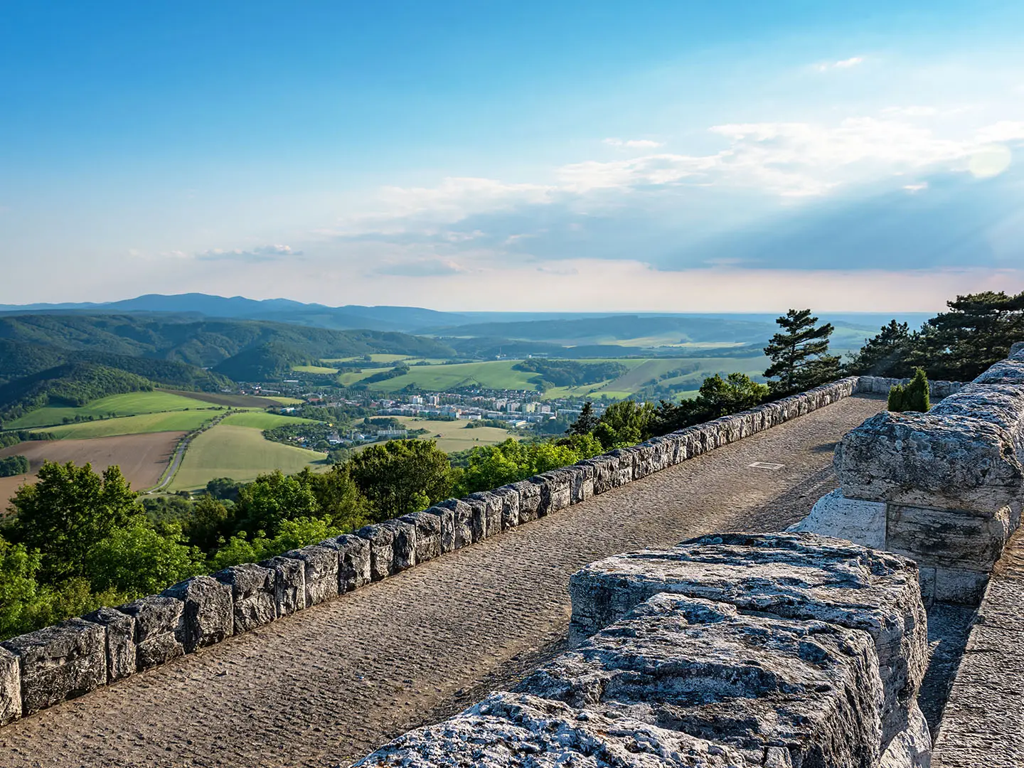
- Bradlo mausoleum (Mohyla M. R. Štefánika): The monumental terminus above Brezová pod Bradlom, built from pale Spiš travertine and designed by Dušan Jurkovič. It is Štefánik’s tomb, also holding the two Italian airmen who died with him, and is a national cultural monument.
- Záruby (768 m): The high point of the route and the highest summit in the Little Carpathians. It sits in a forested nature reserve north of Trnava, close to other major Little Carpathian summits such as Vápenná and Vysoká.
- Devín Castle: On the Devín-start variant, this ruined fortress stands where the Morava meets the Danube. It has been a stronghold since Great Moravian times and is a Slovak national symbol.
- Devínska Kobyla and Sandberg: This Bratislava-edge massif gives the route an early mix of woodland, open views and geology. Sandberg is a fossil-rich sandy outcrop, once the bed of an ancient sea, with views towards Austria.
- Castle ruins along the ridge: The line passes medieval hrad ruins including Pajštún, Ostrý Kameň, Plavecký hrad and Dobrá Voda. They mark the old frontier and trade-route landscape of the Little Carpathians.
- Little Carpathian wine country: Around Modra, Pezinok and Častá the trail skirts one of Slovakia’s oldest viticultural areas, adding vineyard tracks and wine towns to the forested ridge walking.
Challenges to expect
The difficulty comes from distance, repeated hills and self-sufficiency, not altitude: the highest point is under 800 m, but total ascent is roughly 4,759 m. Waymarking can fade or disappear, so carry detailed VKÚ/Harmanec maps. There are no purpose-built trail huts; accommodation needs planning in nearby towns and villages, or careful improvised camping. Summer heat can be an issue on open and shadeless sections.
HikeList Score
Štefánikova Magistrála scored 75/100 on HikeList's trail-quality metrics.
See score breakdownHide breakdown
- Ideal length 78
- Balanced challenge 84
- Scenery & wildness 66
- Varied terrain 100
- Accommodation 58
- Food & support 65
- Path quality 81
- Season flexibility 89
Computed from length, challenge, scenery & wildness, terrain variety, accommodation, food & support, path quality and season flexibility.
 Slovakia
Show more data Show less
- Forested Hills
- Ridge
- Vineyard Country
- Lowland Edges
- Suburban Edges
- Forest Paths
- Farm Tracks
- Vineyard Tracks
- Road
- Suburban Paths
- Villages And Towns
- Wild Camping Spots
- Pet Friendly
- Water Sources
- Campsites
- Shelters
Photos from hikers
Taken on the trail by people who've reviewed Štefánikova Magistrála.
The hike begins from Bratislava’s outskirts at Koliba or Devínska Kobyla and quickly enters the forested hills of the Little Carpathians. The trail passes by Kamzík Tower before ascending to the scenic ruins of Pajštún Castle. Expect varied forest terrain, a few gentle climbs, and panoramic views over western Slovakia. The day’s trek concludes in Borinka village, a historic settlement nestled in the hills.
From Borinka, the route continues along well-marked forest trails, steadily climbing to Vápenná (Roštún), one of the highest peaks in the Little Carpathians. After Vápenná, the path descends toward the villages of Sološnica and Plavecké Podhradie, near the striking ruins of Plavecký Castle. The section ends in Smolenice, a charming town with a fairytale castle and various lodging options.
Leaving Smolenice, you’ll traverse through lush forests and open meadows, passing the Devil’s Gorge (Čertov žľab) and gradually climbing to Záruby, the trail’s highest point. The route then weaves along forested ridges dotted with wildflowers and occasional viewpoints before reaching the historic village of Dobrá Voda, known for its castle ruins and tranquil surroundings.
The final section leads from Dobrá Voda through undulating wooded hills, passing a series of minor peaks and traditional mountain huts. This stretch is quieter, offering solitude and opportunities to spot wildlife. The trail concludes at the majestic Štefánik’s Barrow (Mohyla na Bradle), a national monument with sweeping vistas and a fitting end to the journey.
Reviews
How would you rate Štefánikova Magistrála?
Tap a star to start your review — you could be the first.